Wiverton Conservation Area
Wiverton Conservation Area Appraisal and Management Plan April 2023

Contents
1.1 Conservation Areas
1.2 The Purpose of a Conservation Area Character Appraisal
1.3 The Planning Policy Context
2 Wiverton Location and Landscape Setting
3.1 Historical Overview
3.2 Location and Historic Activities
3.3 Historical Mapping
4.1 Plan, Form and Layout
4.2 Landmarks, Focal Points and Views
4.3 Open Spaces, Trees and Landscape
4.3.1 Open Spaces, Trees and Landscape SWOT Analysis
5 Buildings of the Conservation Area and Key Characteristics
5.1 Building Types and Activity
5.1.1 Building types and Activity SWOT Analysis
5.2 Key Characteristics and Building Materials
5.2.1 Key Characteristics: Entrance and Current Settlement - Zone 1
5.2.2 Key Characteristics: Areas North and South-southeast of Wiverton Hall - Zone 2
5.2.3 Characteristic Zone Map
5.3 Listed buildings
5.4 Key Unlisted Buildings
5.4.1 Details and Materials
6.1 Introduction
6.2 National and Local Policies and Guidance
6.3 Article 4 Directions
6.4 Building Design
6.5 Publicity and Knowledge Transfer
6.6 Public Realm
6.7 Boundary Treatments
6.7.1 Walls and Fences
6.7.2 Hedges
6.8 Buildings at risk
6.9 Enforcement
7 Appendix 1 – John Smythson's Plans
8 Appendix 2 – The Lost Churches of Wiverton
9 Appendix 3 – Listed Buildings (as of April 2023)
10 Appendix 4 – Conservation Area Boundary and Townscape Appraisal Map
1 Introduction
1.1 Conservation Areas
Rushcliffe Borough Council has an obligation under Section 69 of the Planning (Listed Buildings and Conservation Areas) Act 1990 to review, from time to time, its Conservation Area designations.
A Conservation Area, as defined under Section 69, is ‘an area of special architectural or historic interest the character or appearance of which it is desirable to preserve or enhance’.
Thoroton Conservation Area was designated in December 1973. Prior to the current (2023) appraisal document, the most recent
appraisal of the Thoroton Conservation Area was carried out in March 2006.
Section 71 of the Planning (Listed Buildings and Conservation Areas) Act 1990 highlights the local planning authority’s duty to formulate and publish proposals for the preservation and enhancement of the conservation areas. This document, therefore, aims to identify and
reaffirm (or redefine) the special architectural or historic interest of the area which warrants its designation.
Conservation Area Appraisals are not, and never have been, tools for fossilising a place against change, instead, the processes of change which allow places to grow and evolve are recognised as being unavoidable, and it is also recognised that change can be a positive and desirable force. The designation instead allows greater scrutiny and control to manage change to positive effect and to ensure that any changes which require planning permission do not harm, and ideally serve to actively enhance, the existing character of the place.
Wiverton Conservation Area: Summary of Special Interest
The secluded setting of Wiverton and Wiverton hall contribute to the character of the conservation area.
There are a number of significant views in and out of Wiverton. Views can be found on the townscape appraisal.
There are two scheduled monuments within the conservation area, which could provide an insight into earthwork engineering of the past.
The tree lined approach to the village creates a dramatic entrance, where Wiverton Hall is only visible from close proximity.
Many of the properties within the village are listed.
1.2 The Purpose of a Conservation Area Character Appraisal
The purpose of a Conservation Area Character Appraisal is to:
- Identify and record the special interest of the Conservation Area to ensure there is public awareness and understanding of what is
worthy of preservation. - To define and reassess current boundaries to accurately reflect what is now perceived to be of special interest.
- To identify opportunities to safeguard and enhance the special interest of the Conservation Area.
It should be noted that the content in this document is not a comprehensive account of every significant building, structure, tree, wall, feature, or space. Therefore, any omission should not be assumed to imply that they are of no interest.
Generally, the character and appearance of a Conservation Area will be preserved or enhanced by:
- Providing controls and regulating development through the planning system.
- Applying the extra controls that designation provides over demolition, minor development, and the protection of trees.
- Environmental enhancement schemes and possibly providing financial assistance for the repair and restoration of specific buildings.
- Encouraging public bodies such as the local highways authority or utility companies to take opportunities to improve the street scene through the appropriate design and sensitive sighting of street furniture (and retention of historic features of interest), or the removal of eyesores and street features that have a negative impact such as overhead wires.
Wiverton Conservation Area: Summary of Key Issues
There have historically been issues with the management and maintenance of the scheduled monuments (pre-dating the owners at the time of this appraisal).
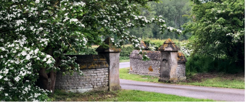
Access to Wiverton is from a high-speed road near a bend. In the past this has contributed to the damage of the gate piers.
1.3 The Planning Policy Context
This appraisal provides a firm basis on which applications for development within the Thoroton Conservation Area would be
assessed. It should be read alongside the wider development plan policy framework produced by Rushcliffe Borough Council and other
National Planning Policy Guidance documents. The relevant documents include:
- Rushcliffe Local Plan Part 1: Core Strategy, with a specific focus on:
- Policy 10 (Design and Enhancing Local Identity) [in part]
- Policy 11 (Historic Environment)
- Rushcliffe Local Plan Part 2: Development Policies, with a specific focus on:
- Policy 28 (Conserving and Enhancing Heritage Assets)
- Policy 29 (Development Affecting Archaeological Sites)
- The National Planning Policy Framework (NPPF) (Revised -2024)
- The National Planning Practice Guidance (2015 - Subject to Continual Review)
- By Design: Urban Design in the Planning System – Towards Better Practice (2000)
- The Planning (Listed Buildings and Conservation Areas) Act 1990
2 Wiverton Location and Landscape Setting
Rushcliffe Borough forms the southern tip of Nottinghamshire, which borders Leicestershire. It is predominantly a rural Borough that contains a mixture of city suburbs, market towns and villages. Rushcliffe is located about half a mile South of Nottingham city centre, with the River Trent forming the majority of its northern boundary and the River Soar defining its western boundary.
The A46, a distinctive Roman Road, runs through the centre of the Borough and leads to Newark in the North and Leicester in the South. In the northern half of the Borough, the A52 forms Nottingham’s primary transport link to Grantham and the East of England. Junction 24 of the M1 and East Midlands Airport are located about 1 mile from the western border.
The hamlet of Wiverton is situated in the southeast of the Borough, two miles south of Bingham. Wiverton is surrounded by the villages of Tythby, Langar and Barnstone and is approximately five miles from the Leicestershire border to the south and three miles from the Leicestershire border to the east. The River Smite, which becomes the River Devon at Bottesford, and joins the River Trent at Newark, divides the parish.
Wiverton is surrounded by its own ancient orchard, woods, a meadow and farmland, the latter being owned by The Crown Estates and leased long term to a local farming family.
The old parish of Wiverton Hall should not be confused with the modern Anglican parish of Wiverton in the Vale, incorporating the churches of Tithby, Colston Bassett, Cropwell Bishop, Cropwell Butler, Elton-on-the Hill, Langar, Barnstone, Granby and Sutton.

3 Historical Contexts
3.1 Historical Overview
The earliest indications of human settlement at Wiverton are from the Iron and Bronze Ages.
There was a Roman settlement at Wiverton, and the village was possibly linked to Langar and Bingham by a Roman road. Indications of the Roman grid system of roads is evident on old maps in the area.
The parish of Wiverton Hall, dating from the medieval era, at 1.8 square miles, is one of the smallest parishes in the country. It consists mainly of farmland, largely owned by the Crown Estates, but also incorporates the modern hamlet of Wiverton and the medieval lost village of Wiverton. The parish is bisected by the River Smite, a tributary to the Trent.
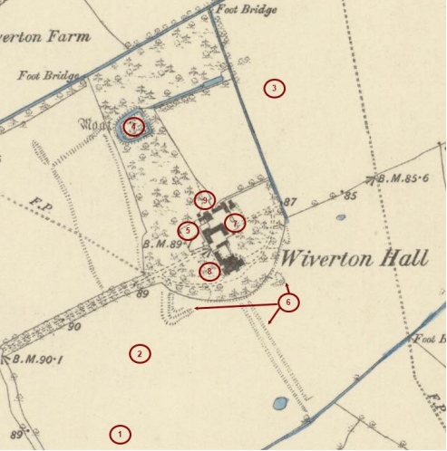
Six of the properties within Wiverton are Listed buildings, consisting of five Grade 2 Listed cottages and Wiverton Hall, which is Grade 2* Listed. The parish also has two Scheduled Monuments: The Moat and Fishpond, which dates back to the 11th century or 12th century, and the Medieval Lane, also known as the Covered (or Covert) Way. The Gun Battery redoubt is linked in the scheduling to the latter, dating back to the Civil War when Wiverton was fortified in 1642 (see Figure 2). There were originally two-gun batteries, but one was ploughed up in the early 20th century.
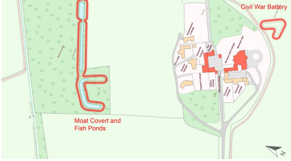
The scheduled monuments to the north of Wiverton Hall include earthworks defining a sub-rectangular moat, suggesting the original location of the manorial house, and fishponds. Most moated sites of prestigious residences served as a status symbol rather than a practical military defence. Many moated sites of this type were built was between about 1250 and 1350 and are important for the understanding of the distribution of wealth and status in the countryside.
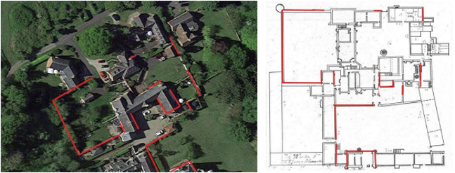
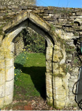
In 1448 Sir Thomas Chaworth had a new manor house built to the south-east of the moated site and was granted licence to make a deer park, but relatively little is known about it. Figure 6 and Figure 7 show the similarities in the layout of the original design and the remaining stone walls.
The scheduled monuments to the southeast of the hall include the remains of a Civil War gun battery constructed by the Royalist garrison defending Wiverton Hall, and an adjacent covered way, following the course of an earlier medieval trackway containing the contemporary entrance to the house. These earthworks to the southeast of the hall, raised during the military campaigns, acted as gun emplacements, and provided temporary protection for those in close range combat and travelling to and from the hall. The earthworks
consisted of banks and ditches can be recognised today as surviving earthworks, as crop and soil marks on aerial photographs.
On November 9th, 1645, during the Civil War, a Parliamentarian force under Colonel-General Sydenham Poyntz surrounded the Royalist garrison holding Wiverton Hall and demanded their surrender. The earlier Wiverton Hall dating from 1448 was destroyed during the siege to prevent it being re-occupied. Following the siege, the garrison left behind their arms and provisions. There is therefore a unique opportunity to study the field engineering of the Civil War, and potentially furthers the archaeological interest of the area.
The present Wiverton Hall was built in 1815 with Strawberry Hill Mock Gothic additions onto the remains of the medieval gatehouse. The current hamlet of Wiverton was developed in the late 20th century and early 21st century, with some conversions from the old stable block and some new buildings. The hamlet consists of twelve private properties in close proximity to Wiverton Hall.
Nottinghamshire County Council and Historic England undertook a desk-based archaeological site assessment of Wiverton Hall and produced an interpretation of the aerial photographs and Environment Agency LiDAR (Light Detection and Ranging: a remote sensing technique, used for high-resolution survey of landscapes). The extensive remains of earlier settlement and cultivation have been noted surrounding the Hall, beyond the scheduled monument. These remains, which are visible as cropmarks and earthworks on both aerial photographs and LiDAR, include the cropmark of a probable medieval settlement, boundaries, and ridge and furrow cultivation to the immediate east of the Hall, much of which was still largely earthwork in the 1960s but has since been ploughed leaving only slight earthwork remains.
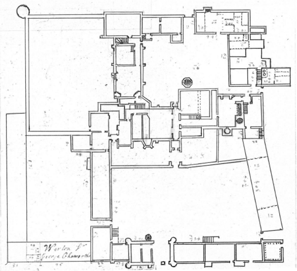
An archaeological survey of February 2023 suggested that many of the houses in the hamlet may be built on the foundations of the 1448 Hall, with one cottage, The Stables, potentially lying on the medieval foundations and retaining the entrance points originally used in 1448. The Georgian central courtyard is on the site of a medieval great hall which is believed to have had a wooden screen with a gallery above. This was detailed in the sketch plan produced by the architect John Smythson circa 1610 (Appendix 1 - John Smythson's
Plans). The plans also show an oriel window, similar to the one at Gainsborough Old Hall, also designed by Smythson.
Folklore tales have also contributed to the social value of Wiverton in recent history.
Conservation Area Boundary covers: 8.1 ha (approximate)
Number of Grade 1 listed buildings: 0
Number of Grade 2* listed buildings: 1
Number of Grade 2 listed buildings: 1
Scheduled Monuments: 2
A full list of Wiverton Conservation Area’s Listed buildings can be found in Appendix 3
Details accurate as of April 2023
3.2 Location and Historic Activities
The siting of the earliest settlements at Wiverton appears to have been influenced by the proximity of the River Smite and some ancient (possibly Roman or pre-Roman) roads. This area around the hamlet is of special historical interest due to the evidence of a settlement from the Iron Age, Bronze Age, through the Roman occupation, and Saxon settlement (the so-called Dark Ages) to medieval times.
- Bronze Age Settlement - 3300BC to 1200BC
- Roman Occupation - 43BC to 410CE
- Saxon Village - 600CE to 1066CE
- Medieval moated manor circa - 1100CE
- Late medieval palace - 1448
- Civil war 1642-1651
- Georgian hunting lodge and stable block circa 1815
- Hall and grounds as a Victorian family residence from 1850
- Modern hamlet 1993 onwards
There are traces of a Bronze Age Circle in the field south of the entrance avenue. In addition to this, there have also been some finds of pottery remains from a Roman settlement. Vestiges of a Roman (or possibly earlier) road cross the fields on either side of the entrance avenue. This road passes close to the site of the previously mentioned Roman building.
The hamlet’s name has Saxon origins, meaning Wigfrid’s tun (Wigfrid’s farm/settlement), although the spelling has changed and evolved over the centuries.
Wiverton is recorded in the Doomsday Book as having 29.5 households, which could have been upwards of 150 people and consequently in the top 40% of villages according to its population. Wiverton was considered a large settlement and comparable to Bingham, which at the time of the Doomsday survey, had around 32.5 households.
These dwellings in Wiverton were reduced to just four houses and a cottage following a period of emparkment, (a process where aristocrats chose to move or demolish dwellings within their land to make way for more parkland). George Chaworth undertook this process of emparkment in 1510 and enlarged his park by 254 acres (103 hectares).
There are two lost churches at Wiverton; the Chapel of St Laurence in the medieval palace, recorded in Sir Thomas Chaworth’s Will, and an earlier church or chapel referred to frequently in the Thurgarton Cartulary during the 12th and 13th centuries (see Appendix 2 - The Lost Churches of Wiverton).
There are moats in evidence on old maps and from LiDAR photographs (see Figure 4). There are remains of a moated site and fishponds 225m north of Wiverton Hall which is now a scheduled monument.

A geophysical survey of 2021 suggested the remains of a previously unknown brick or stone building beneath the ground in the meadow to the north of Wiverton, just outside the Scheduled Monument, Moat and Fishponds (see Figure 5). The survey showed that the full extent of this building is at least 25 metres by 10 metres, however, it did not detail the nature of the structure.
Cropmarks have been reported during recent droughts, which suggest other sites of ancient formal gardens and earlier buildings which have since been destroyed.
An outstanding feature of the hamlet is the remains of a palatial earlier Wiverton Hall, built circa 1448 by Sir Thomas Chaworth and destroyed during the Civil War.
Archaeological work was carried out in February 2023 to record the extent of these remains and determine whether the architect John Smythson’s plans for amendments to the palace, dated 1610 and 1615, were carried out before parliamentary troops destroyed the mansion in November 1645.
It cannot be known if the remaining stone structures are the built remains of the palace or were built more recently using material remains from the destruction of an alternative design, however Figure 6 and Figure 7 show the similarities in the layout of the original design and the remaining stone walls.
3.3 Historical Mapping
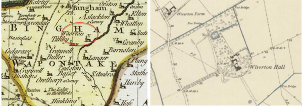
The Map of 1883 depicts the layout of the site much as it is today except that the wooded area has more of
an association with the hall and there are additional watercourses that have since been ploughed out.
4 Spatial Analysis
The relationship between open spaces and the built form within a conservation area can be central to its character. This section describes the village’s layout, highlighting the significant views, landmarks and historical focal points. The contribution of open green spaces, trees and other natural elements to the conservation area’s character is also described within this section.
4.1 Plan, Form and Layout
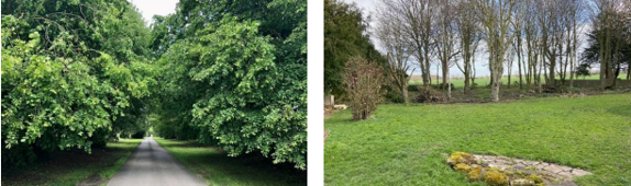
The hamlet of Wiverton is now accessed via a quarter mile long tree lined avenue. At the end of the road is a cluster of properties within an almost circular plot of land. In addition to the Hall, the properties comprise of three groups of houses, centred around two courtyards and a green which has an old oak tree in its centre.
The hamlet is surrounded by open farmland belonging to the Crown Estates, but in addition it has two areas of woodland, an old overgrown orchard, and a five-acre meadow. Grass verges at the sides of all the roads and the tree-lined approach avenue add to the sense of openness throughout the hamlet.
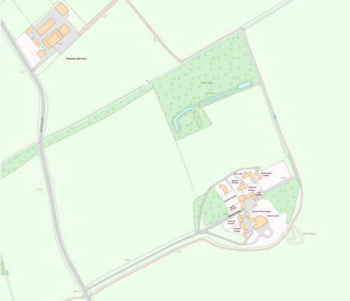
The plan above shows the setting of the hamlet, secluded from other settlements; with no through road, it is only accessible via a drive that is accessed by a decorative gateway and tree lined driveway off Bingham Road.
4.2 Landmarks, Focal Points and Views
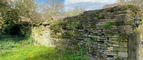
The decorative wall that forms the gateway entrance to Wiverton and Wiverton Hall is a locally recognised landmark. The entrance road is flanked by two tall gate piers, capped with pyramidal stone pier caps. A blue-lias stone wall curves out from the gate piers to emphasise the entrance gateway, although the southern wall is in need of repair following damage.
The gateway opens onto a long, treelined avenue. The trees were originally elms, but these succumbed to Dutch elm disease in the 1970s and have been replaced largely by sycamores (see Figure 11). The hamlet and Hall cannot be seen from the entrance at Bingham Road. However, the Grade 2* listed Hall can be seen through breaks in the hedges along Bingham Road, from nearby footpaths and from points within Langar to the south.
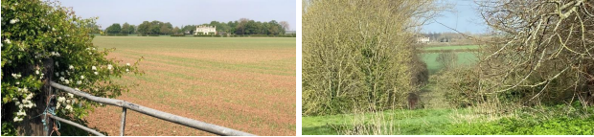
The location of Wiverton within its setting provides views out across open country from multiple locations within the hamlet. Wiverton Hall is also a landmark within the wider setting and can be visible from the Belvoir ridgeway, travelling north from Langar on the C28, from Barnstone Lane, and from Cropwell Road Langar.
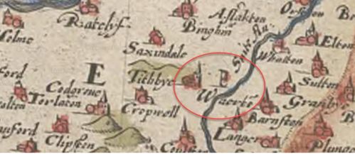
This history of the area presents an opportunity to further understand the lost village of Wiverton through archaeological exploration of the paddock and 1448 palace and Goose Green Fields. The lost village can be assumed to be significant due to its presence on historical maps as far back as 1583 (see Figure 8).
4.3 Open Spaces, Trees and Landscape
Beyond the gate piers and wall which mark the entrance to the hamlet, Wiverton Drive is lined with sycamore Trees, framing the driveway to the hamlet. These trees are visible along Bingham Road within the public realm.
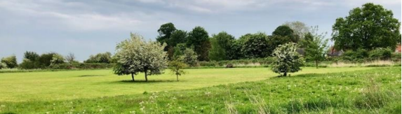
From most of the properties within Wiverton, there are views of open farmland, and from selected areas within the hamlet there are views of Belvoir Castle and the Vale of Belvoir.
Within the grounds of Wiverton Hall there is a tree known as The Cedar of Lebanon (Cedrus Libani) which was planted in memory of Leela Keshavji. This tree was planted to commemorate the life of a significant figure who championed organ donation awareness, contributing to the changing perceptions of organ donation within the underrepresented South Asian community. Leela’s legacy lives on beyond the grounds of Wiverton Hall.
Cedar was once planted on nearly all the grounds of stately homes and mansions within the UK from 1740s onwards, this practice is less common today. The cedar tree is identified on the Townscape Appraisal as a significant tree.
The limited population and secluded location have led to Wiverton becoming a sanctuary for wide variety of flora and fauna: e.g., badgers, bats, muntjac deer, roe deer, stoats, weasels, polecat, hares red kites, buzzards, eagle, egrets, woodpeckers, kingfishers. There are also snowdrops and aconites on the drive, oaks, yews and box trees within the village.
4.3.1 Open Spaces, Trees and Landscape SWOT Analysis
Strengths - what are the positives of the open spaces, trees, and landscape
- Tree Preservation Orders on some trees, which will help maintain the character of the area.
- Scheduled Monument Gun Battery and Covered Way in open countryside.
- Views of open farmland, Belvoir Castle and Vale of Belvoir.
- Sanctuary for wide variety of flora and fauna.
Weaknesses - what are the negatives of the open spaces, trees, and landscape
- Not all the trees are covered under the current tree protection order.
- Some woodland areas are not maintained.
- Much of the moat needs to be maintained as some areas have been filled in with garden waste and rubble.
Opportunities – what could make the open spaces, trees, and landscape better?
- Consider the potential preservation of other trees within the area.
- Manage wooded areas.
- Record the wildlife.
Threats - what would make open spaces, trees and landscapes worse?
- Further unauthorised land clearance and moat infilling.
- Insensitive industrialisation of the area e.g., solar farms.
Works to Trees
You must contact the Local Planning Authority (LPA), Rushcliffe Borough Council before any works (cutting OR pruning) are carried out to trees within the Wiverton Conservation Area.
Six weeks’ notice is required before any works to trees within the Conservation Area is carried out, even if they are not protected by a Tree Preservation Order (TPO).
If there is a tree which undergoes annual maintenance, include this information with the notice. It may be possible, upon agreement with the tree officer, that only one notice is required to cover the future annual maintenance.
Standard notification forms (a section 211 notice), further information and contact details.
A flow chart of the decision-making process regarding works to trees.
5 Buildings of the Conservation Area and Key Characteristics
5.1 Building Types and Activity
The hamlet of Wiverton consists of thirteen dwellings, two of these are medieval or part medieval, six Georgian and five new builds. The latter have been designed to complement the older buildings, each other, and their surroundings.
5.1.1 Building types and Activity SWOT Analysis
Strengths - what activities/places can you go that make the village/town great?
- A scenic hamlet with 13 dwellings and unrestricted countryside views direct from most gardens.
- Strong community spirit throughout the hamlet, with numerous events held throughout the year in private gardens and land.
- Access to walking the many public footpaths in the surrounding area.
Weaknesses - what activities/places exist that detract from making the village/town great?
- none
Opportunities - what activities/places could exist that would village/town even better?
- A defibrillator placed in the hamlet.
- To widen the gate piers and prevent further damage to the entrance gate way.
Threats - what activities/places would make village/town worse?
- Industrialisation (e.g., solar farms) that fails to contribute positively and enhance the character of the area.
- Further damage to the gate piers.
5.2 Key Characteristics and Building Materials
5.2.1 Key Characteristics: Entrance and Current Settlement - Zone 1
While the area is characterised around Wiverton Hall and its former service range and stables, views of the front façade of Wiverton Hall are limited to the comparatively short approach after passing the former service range.
The older properties centre around a courtyard space. There are limited views of any of the properties as from the entrance gate, due to the tree lined driveway, which adds a sense of mystery upon the approach.
Materials:
Walls: There are many examples of the use of stone and brick within the same building which contributes to the visual narrative of the area. Much of the stone is believed to be medieval, however, in some cases it is challenging to distinguish medieval stonework
foundations or the more recent reuse of loose medieval stone.
Roofs: The roofs in Wiverton are predominantly pitched.
Windows: Timber sash windows.
Key Characteristics / Architectural Features:
Characterised by the early tutor revival Wiverton Hall and service range (circa 1815).
Brick and stone walls, occasionally evidenced on the same elevation.
Hamlet with very few properties all accessed via a single tree lined driveway.
5.2.2 Key Characteristics: Areas North and South-southeast of Wiverton Hall - Zone 2
The area North of Wiverton Hall is associated with the early settlement of Wiverton, with the Moat and Fishponds believed to be the site of the manorial house. Now a scheduled monument the largely undisturbed moat and fishponds and its surrounding area offers the opportunity to explore Wiverton’ s past through archaeological exploration.
The land south-southeast of Wiverton Hall is owned by the Crown Estate (at the time of writing the appraisal) and is a portion of the 7,920 square kilometres of agricultural and forest land owned by the Crown Estate. The significance of this area lies in its connection with the Civil War and the engineered earthwork remains. This site offers an opportunity to further explore the engineering of the Civil War.
Materials:
Earthwork remains.
Key Characteristics / Architectural Features:
Three scheduled monuments within the two areas.
The Fishponds and Moat in the area to the north, which were most common in the hundred years between 1250 and 1350.
To the southeast, the gun battery and covered way associated with the civil war (1642-1652).
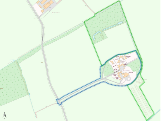
Zone 1: Blue dots - Entrance and Current Settlement
Zone 2: Green dots - Areas North and South-southeast of Wiverton Hal
5.3 Listed buildings
Buildings on the Government’s List of Buildings of Special Architectural or Historic Interest are called “Listed” buildings and are protected by law. Consent is required from Rushcliffe Borough Council before any works of alteration, extension, or demolition can be carried out on any listed building.
Further information can be found in Rushcliffe Borough Council’s publication Listed Buildings in Rushcliffe.
There is also the complete and up-to-date list of the Secretary of State’s Statutory List of Buildings of Special Architectural Interest or Historic Interest.
Names of the Listed Buildings and structures in Wiverton Conservation Area (correct as of April 2023) are detailed in Appendix 3. All Listed Buildings are shown on the Townscape Appraisal plan, but some smaller structures such as gravestones may not be shown.
There are two listings within Wiverton. The first is Wiverton Hall including the Service Range to the rear left, this now consists of several properties including Wiverton Hall Cottage, Peacock Cottage, Cromwell Cottage and Pheasant Cottage.

Wiverton Hall - Grade 2* Listed Building. North façade constructed c1448 as the gatehouse to the palace built by Thomas Chaworth. The south face (as shown in the image above) and remainder of the Hall was built by Sir George Chaworth circa 1815 as a hunting lodge in Tudor Revival Style. Fine ashlar. Round angled turrets and string courses. A pair of mullioned windows with a flathead flanks the central bay. Tudor arched entrance with two more windows in the 3-storey side bay, with a pair of small ground-floor windows.
Wiverton Hall Cottage - Previously known as the 'Service Range' attached to Wiverton Hall with a hanging franchise within the first floor of the Hall (stone and rendered stone). Listed at the same time as Wiverton Hall.

The second listing is associated with the Paddock Cottage Stable Range, which also consists of several properties, including Willow Cottage, Paddock Cottage, Charworth Cottage and The Stables.
5.4 Key Unlisted Buildings

Used as the gamekeeper's house until the 1970s.
5.4.1 Details and Materials

6 Generic Management Plan for Conservation Areas in Rushcliffe
6.1 Introduction
In carrying out its planning functions, the Borough Council is required in law to give special attention to the desirability of preserving or enhancing the character or appearance of Conservation Areas. The Management Plan for a Conservation Area is a tool to ensure the special character of the area is preserved and enhanced. The management plans aim to:
- Outline a strategic management proposal for the preservation and enhancement of the Wiverton Conservation Area.
- Act as a guide for professionals and residents alike regarding:
- features of value, worthy of preservation;
- characteristics worthy of preservation;
- opportunities for enhancement;
- development proposals which preserve and enhance the special character of the area.
- Inspire community commitment to conservation principles and reporting.
6.2 National and Local Policies and Guidance
There is a duty to formulate and publish management plans setting out policies and proposals for the preservation and enhancement of Conservation Areas. Many of these policies and proposals are common to all Conservation Areas, and these are set out in this document. The Central Government Guidance and Local policies applicable to Conservation Areas include:
- Rushcliffe Local Plan Part 1: Core Strategy, with a specific focus on:
- Design and Enhancing Local Identity [in part]
- Historic Environment
- Rushcliffe Local Plan Part 2: Development Policies, with a specific focus on:
- Conserving and Enhancing Heritage Assets
- Development Affecting Archaeological Sites
- The National Planning Policy Framework (NPPF), particularly, but not exclusively the chapter on Conserving and Enhancing the Historic Environment.
- The National Planning Practice Guidance (NPPG) (updated 2021 and subject to continual review)
- By Design: Urban Design in the Planning System – Towards Better Practice (2000)
- The Planning (Listed Buildings and Conservation Areas) Act 1990
- Historic England “Historic England Advice Note 1: Conservation Area Designation, Appraisal and Management”
The council will utilise the full range of strategic policy and guidance documents to ensure that development in Wiverton Conservation Area is of a standard that enhances the amenity of the local area. The council will always look to use the most up-to-date versions of the document.
Supplementary documents may be issued for individual Conservation Areas where specific policies or proposals are needed.
6.3 Article 4 Directions
There are extra consents required in Conservation Areas. For example, in addition to the general control of development, you will
need to get permission for
- Any additions or alterations to the roof (for example, dormer windows)
- The installation of satellite dishes on chimneys, roofs or walls fronting a highway
- Any extension which extends beyond the side of the original dwelling house
- Any extension of more than one storey that extends beyond the rear wall of the original dwelling house
- Cladding the exterior of the dwelling
- Any demolishing of a building or part of a building that has a volume over 115 cubic metres
Article 4 of the Town and Country Planning (General Permitted Development) Order 1995, allows planning authorities to restrict
some permitted development rights within particular areas. This does not necessarily prevent development or change taking place
but enables the Local Authority to manage the design and detailing of the works, and potentially grant permission subject to appropriate conditions. The use of Article 4 Directions will be proposed where it is considered appropriate following the completion of each Area Appraisal across the Borough.
Details of Article 4 Directions for Wiverton Conservation Area
There are currently no Article 4 Directions for Wiverton Conservation Area.
6.4 Building Design
Mimicking the local vernacular is not the only way to ‘fit in’ with the character of a conservation area. National policy makes clear that contemporary designed, provided it is sympathetically designed, cannot be dismissed as an option. Therefore, good contemporary design will be encouraged where it respects the context’s character, scale and massing. This must be demonstrated in the Design and Access Statement submitted with any planning application.
Extensions to buildings in Conservation Areas should respect:
- The key characteristics of the original building, including scale, mass, materials and proportions
- The contextual setting and character of the Conservation Area
Copying like for like can devalue and destroy the ability to “read” historic change, and dilutes our historic heritage. Pastiche designs, incorporating poor imitations of other styles, will be resisted, particularly where they incorporate details which are not locally appropriate. Careful high-quality replication may be required in a few very sensitive locations.
In particularly sensitive locations, such as uniform terraces, exact replication may be necessary to maintain compositional unity. In that case, attention to details, choice of materials and high-quality workmanship are the keynotes. However, in some cases, a direct relationship is not impossible. For example, Flemish Bond brickwork cannot be replicated in cavity walls, and narrow lime mortar joints cannot be replicated in modern metric brickwork.
Where a new building is appropriate, on infill sites or where an existing building detracts from the character of the area, the opportunity should be taken to re-establish the streetscape, reinforce enclosure, open up distant vistas or views of landmarks or hide unsightly views.
“New and old buildings can coexist happily without disguising one as the other, if the design of the new is a response to urban design objectives” (DETR – “By Design”, p19).
As with extensions, good contemporary design which respects local character, and the context of the site will be encouraged.
All new buildings should respond appropriately to the existing frontage and normally follow the established building line. Development or redevelopment will normally be resisted if:
“it blocks important views identified in the individual appraisals, uses important open spaces identified in the appraisals, adversely affects the setting of any Listed or key buildings, fails to maintain or re-establish the streetscape where appropriate dominates its Conservation Area background fails to recognise the context of
the site destroys important features identified in the individual appraisals such as boundary walls, fences,
hedgerows or trees”
Where the quantity of contemporary schemes in a small area becomes significant and outnumbers older buildings within the area, further contemporary schemes could fundamentally shift the architectural character of the area and thus be harmful, even if well designed as an individual project.
New development that stands out from the background of buildings may be appropriate in exceptional circumstances if it contributes positively as a landmark to enhance the street scene, to highlight a corner or to signal a visual change of direction such as along a curving vista.
Any external lighting should be carefully designed and sited to minimise light pollution. Energy producing or saving devices are generally welcomed by the Council, but careful consideration is required when these are to be located in a Conservation Area and some may require planning permission. In particular, they should be positioned to minimise their impact on the building and on the local amenity.
6.5 Publicity and Knowledge Transfer
Ambiguity about additional controls within a Conservation Area raises the likelihood of inappropriate developments occurring which
may damage the integrity of the conservation area designations.
Efforts have been made to engage local community groups in the development and review of the character appraisals. Empowering
communities to define the special architectural and historic interest of the Conservation Area aims to raise awareness.
Whether the appraisal took a community-led or a council-led approach, upon reviewing all Conservation Areas, the public were invited to ask questions and comment during a public consultation. A consultation event also aimed to diminish any ambiguity about
restrictions within a Conservation Area and increase the likelihood of sensitive and appropriate developments, maintaining the character
of the area.
The council recognise the potential issues of turnover in residency and ownership of properties in the conservation area. Therefore,
Rushcliffe Borough Council will periodically use their media outlets to highlight conservation area designations and the significant,
related planning controls.
The approach taken within Wiverton Conservation Area was Community Led.
The consultation period took place between the following dates – 10/07/2023 and 01/08/2023
The date of the Consultation Event 24/07/2023
If there are any queries about conservation areas, please email conservationareas@rushcliffe.gov.uk
6.6 Public Realm
General maintenance and upkeep to the public realm may include fixing damage to roads and pavements, and fixing issues with street lighting. Issues such as these can impact the quality of the Conservation Area.
The council aims to encourage works to the public realm that are in keeping with, or actively enhance the conservation area. Rushcliffe Borough Council can only advise on work within the public realm that does not require planning permission (for example work completed by statutory undertakers, such as the Highways Authority). In these instances, Rushcliffe borough council cannot prevent such work.
Nottinghamshire County Council are responsible for repairs to roads, pavements and street lighting. Report issues of repairs to roads, pavements and street lighting to Nottinghamshire County Council online.
Rushcliffe Borough Council will continue to undertake their duties in maintaining the public realm. Vandalism, fly tipping and street cleaning are all the responsibility of Rushcliffe Borough Council. Report issues to Rushcliffe Borough Council online.
You must contact the Local Planning Authority (LPA), Rushcliffe Borough Council, before any works (cutting OR pruning) are carried out to trees within the Wiverton Conservation Area
Six weeks’ notice is required before any works to trees within the Conservation Area is carried out, even if they are not protected by Tree Preservation Order (TPO).
Standard notification forms (a section 211 notice) - further information and contact details.
A flow chart of the decision-making process regarding works to trees.
6.7 Boundary Treatments
Where there is a proposal for a new boundary treatment to be installed, the council would encourage the use of boundary treatments within the area.
Within conservation areas, planning permission is required to alter, maintain, improve, take down or build any new gate, fence, wall or other enclosure with:
- A height of one metre or more if next to a highway (including a public footpath or bridleway), waterway or open space; or
- A height of two metres or more elsewhere.
Where planning permission is required to remove a wall, Rushcliffe Borough Council will aim to protect those boundary walls and fences that have been identified as positively contributing to the area.
Hedgerows are significant habitats for wildlife in lowland Britain. Regulations are intended to protect important hedges in the countryside. The policy applies to hedges that are more than 20m long, (or less if connected to another hedge) on or adjacent to:
- Land used for agriculture or forestry, including the keeping of horses or donkeys
- Registered common land and village greens
- Local Nature Reserves and Sites of Special Scientific Interest.
The policy does not apply if the hedge is within or on the boundary of the curtilage of a house.
6.8 Buildings at risk
A few of the important buildings across the various Conservation Areas are currently vacant or not in regular use, which may lead to some being “at risk” of neglect or decay.
The Council will encourage and advise on renovation and repair work that is sensitive to the original or traditional historic character of the building and retains original features. The council will monitor the opportunity and potential for grant aid schemes to encourage the basic maintenance work necessary to ensure that key buildings within the conservation area are structurally sound and weather tight. However, given the current financial climate and outlook, such schemes are unlikely in the short to medium term.
There is a presumption against the demolition of buildings which contribute to the character of the area unless there are exceptional circumstances. It would benefit both the physical form and the function of the Conservation Area if these buildings were repaired, maintained and brought back into use.
Where the poor condition of a building or structure is as a result of neglect and lack of maintenance by its owner there is no requirement for the Borough Council to take its deteriorated condition into account when deciding whether demolition is appropriate. This is to avoid rewarding the deliberate neglect of buildings by representing such action as a way to obtain planning permission for demolition and redevelopment.
6.9 Enforcement
Rushcliffe Borough Council will, from time to time, assess and monitor changes in the appearance and condition of Wiverton Conservation Area. This will ensure that where necessary enforcement action can be taken promptly to deal with problems as they arise.
Where co-operation cannot be gained by any other means, Rushcliffe Borough Council has the ability to use additional enforcement powers to tackle particular issues within conservation areas. The Council may take formal action if the condition of any building (listed or unlisted) which makes a positive contribution to the character of the Conservation Area is considered to be at risk.
The council will work in accordance with their enforcement policy, which aims to provide an efficient enforcement service in support of the Council’s statutory planning service. Rushcliffe Borough Council’s enforcement actions will remain transparent, consistent, and proportionate, as it is recognised that effective controls over unauthorised development assists in conserving the natural and built environment whilst helping to protect the quality of people’s lives and maintaining the Council’s integrity.
7 Appendix 1 – John Smythson's Plans
Smythson’s 1615 Plan
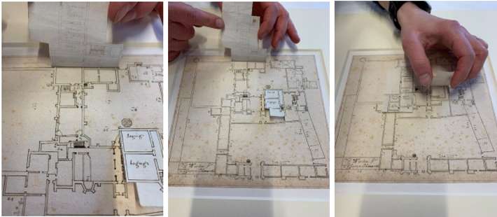
Dated 1615, showing the layout of the medieval building. The original is held at the Royal Institute of British Architects Library and includes notes regarding 'paper flaps' that Smythson attached to his drawing, showing his proposed alterations to the 1448 Wiverton Hall. It is not known whether these alterations were ever carried out.
A request to RIBA in February 2023 resulted in the flaps being lifted and a photograph taken of what was underneath, which showed the original layout. An amended copy of this is shown.
Smythson's plan also shows the 'chapel' and 'former chapel'; the latter would have been an area above the chapel from where the family could worship privately. This is most probably the Chapel of St. Laurence, a private chapel at the old Wiverton Hall which was destroyed during the Civil War. The Chaworth family at that time were Catholic royalists and as such the chapel was highly ornamented with rich hangings and elaborate silverware. This is described in Sir Thomas Chaworth's Will, dated 1459.
The plan also shows a circular building attached to a corner of the northwest curtain wall. This is believed to be a 'Prospect Tower', a wooden building used for viewing the formal gardens below.
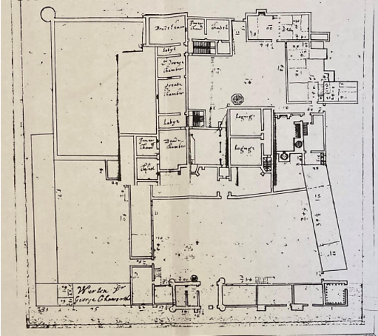
John Smythson's Sketch-plan Dated 1610
This pre-dates Smythson's proposed plan for Wiverton Hall dated 1615 and has rough notes and
measurements. It is not known whether these plans were carried out. The sketch shows the great hall (haulle)
and the wooden screen which would have had a gallery above, the central fireplace and the oriel window. It
also shows three staircases leading to an upper floor.
The sketch-plan shows drawings of two medieval windows which may have been situated in the great 'haulle'.
It also shows formal gardens in the form of parterres. The finely cut edging stone, dating from the C15, is
abundant in the garden of one of the cottages.

John Smythson's 1615 Plan Without the Flaps
8 Appendix 2 – The Lost Churches of Wiverton
Despite the area being called for some administrative purposes 'the Parish of Wiverton Hall', there is no trace of a church building. Numerous records from the Thurgarton Cartulary refer to a church or chapel of ease at Wiverton. Baptisms and marriages could be held at a chapel of ease, but not funerals, which had to take place at the mother church, this being the church of St Andrew at nearby Langar.
In 1215 the will of Aaron of Lincoln showed that the then owner of Wiverton Hall owed him £112 (close to £250,000 in today's money). Aaron was Jewish and specialised in lending money for the building of churches, cathedrals and abbeys. Could this sum have funded a chapel of ease for Wiverton?
In 1297 a deceased Wiverton villager, John de Cropwell, was carried by his friends from home to the cemetery at Langar, two miles away. Once there, they were denied access by the priest from St Andrews, who seemed to think that the cemetery dues would not be paid by John de Cropwell's friends. Outraged by this event, the villagers from Wiverton henceforth refused to make the contribution that they were obliged to pay for maintenance of the Langar cemetery walls, and for this the entire village of Wiverton was ex-communicated
by the Pope. This was a dreadful fate for country people in the C13 and resulted in a protest meeting being held in the church at Wiverton, with a Father Adam from Wiverton village officiating. This event was recorded in the Thurgarton Cartulary.
The Lord and Lady of Wiverton Hall were given permission, during the time of the village excommunication, to hold Mass in their private chapel. To the east of the current Wiverton Hall is a grove of yew trees. Could this be the site of an early medieval church? The Chapel of St Laurence is recorded as having been in the palace built by Sir Thomas Chaworth in 1448, but it could have been on the site of an earlier church. Lady Alice Chaworth, who died in 1400 before the palace was built circa 1448, left in her Will rich fabrics to the church at Wiverton. Her son Sir Thomas's chapel in the palace was very richly decorated, with fine hangings and expensive sets of silverware as described in his Will dated 1459.
The Chapel of St Laurence was destroyed with the rest of the palace in November 1645
9 Appendix 3 – Listed Buildings (as of April 2023)
Wiverton Hall Including Service Range to Rear Left
Grade: 2*
Listing entry number: 1264494
National grid reference: SK 71335 36343
Location: Wiverton Hall Including Service Range to Rear Left, Bingham Road
Paddock Cottage Stable Range North Northwest of Wiverton Hall
Grade: 2
Listing entry number: 1236626
National grid reference: SK 71304 36396
Location: Paddock Cottage, Bingham Road
Moated Site and Fishponds 225m North of Wiverton Hall
Scheduled Monument
Listing entry number: 1017405
National grid reference: SK 71236 36576
Location: Wiverton Hall, Rushcliffe, Nottinghamshire
Civil War Gun Battery and Covered Way Immediately Southeast of Wiverton Hall
Scheduled Monument
Listing entry number: 1017404
National grid reference: SK 71406 36206 and SK 71407 36320
Location: Wiverton Hall, Rushcliffe, Nottinghamshire
*The titles of these listings may not make it clear that all listed buildings always include all attached structures and extensions, regardless of age, and all detached outbuildings built before 1 June 1948 which are, or were at the time of listing, ancillary to the function of the primary listed building and were in the same ownership at the time of listing.
For example, when a house is listed, the listing will apply to extensions, porches, detached historic stables, barns, wash houses, privies etc. Such outbuildings and extensions are only exempt from the provisions of listing where the listing specifically excludes them. Appendix 2 - Conservation Area Boundary and Townscape Appraisal Map.
10 Appendix 4 – Conservation Area Boundary and Townscape Appraisal Map

The Wiverton Townscape Map above shows:
- Locations of listed buildings
- Locations of key unlisted buildings
- Open space
- Locations of trees, hedges, and significant hedges and fences
- Viewpoints
Conservation Areas
- Bingham Conservation Area
- East Bridgford Conservation Area
- East Leake Conservation Area
- Hawksworth Conservation Area
- Hickling Conservation Area
- Ruddington Conservation Area
- Thoroton Conservation Area
- Wiverton Conservation Area
- Langar Conservation Area
- West Leake Conservation Area
- Whatton in the Vale Conservation Area
- Costock Conservation Area
- Sutton Bonington Conservation Area
- Upper Saxondale Conservation Area
- Wysall Conservation Area
- Bradmore Conservation Area
- Car Colston Conservation Area
- Scarrington Conservation Area
- Orston Conservation Area
- Flintham Conservation Area
- Edwalton Conservation Area
- Aslockton Conservation Area
- Bunny Conservation Area
- Granby Conservation Area
- Keyworth Conservation Area
- Thrumpton Conservation Area
- Normanton on the Wolds Conservation Area
- Upper Broughton Conservation Area
- Screveton Conservation Area
- Kneeton Conservation Area
- Colston Bassett Conservation Area
- Cropwell Bishop Conservation Area