Local Plan Part 2: Land and Planning Policies
Rushcliffe Local Plan Part 2: Land and Planning Policies
Adopted October 2019
Contents
- Introduction
-
Housing Development
Policy 2.1 Housing Allocation – Land rear of Mill Lane/The Old Park, Cotgrave
Policy 2.2 Housing Allocation – Land south of Hollygate Lane, Cotgrave
Policy 3.1 Housing Allocation – Land north of Rempstone Road, East Leake
Policy 3.2 Housing Allocation – Land off Lantern Lane, East Leake
Policy 4.1 Housing Allocation – Land off Nicker Hill, Keyworth
Policy 4.2 Housing Allocation – Land between Platt Lane and Station Road, Keyworth
Policy 4.3 Housing Allocation – Land south of Debdale Lane, Keyworth
Policy 4.4 Housing Allocation – Hillside Farm, Keyworth
Policy 5.1 Housing Allocation – Land north of Nottingham Road, Radcliffe on Trent
Policy 5.2 Housing Allocation – Land adjacent Grooms Cottage, Radcliffe on Trent
Policy 5.3 Housing Allocation – Land off Shelford Road, Radcliffe on Trent
Policy 5.4 Housing Allocation – Land north of Grantham Road, Radcliffe on Trent
Policy 5.5 Housing Allocation – 72 Main Road, Radcliffe on Trent
Policy 5.6 Housing Allocation – The Paddocks, Nottingham Road, Radcliffe on Trent
Policy 6.1 Housing Allocation – Land west of Wilford Road, Ruddington
Policy 6.2 Housing Allocation – Land south of Flawforth Lane, Ruddington
Policy 6.3 Housing Allocation – Land opposite Mere Way, Ruddington
Policy 6.4 Housing Allocation – Land north of Asher Lane, Ruddington
Policy 7 Housing Allocation – Land east of Church Street, Cropwell Bishop
Policy 8.1 Housing Allocation – Land between Butt Lane and Closes Side Lane, East Bridgford
Policy 8.2 Housing Allocation – Land south of Butt Lane, East Bridgford
Policy 9 Housing Allocation – Land east of Gypsum Way/ The Orchards, Gotham
Policy 10 Housing Allocation – Land north of Park Lane, Sutton Bonington
Policy 11 Housing Development on Unallocated Sites within Settlements
Policy 12 Housing Standards
Policy 13 Self-Build and Custom Housing Provision
Policy 14 Specialist Residential Accommodation -
Climate Change, Flood Risk and Water Management
Policy 16 Renewable Energy
Policy 17 Managing Flood Risk
Policy 18 Surface Water Management
Policy 19 Development affecting Watercourses
Policy 20 Managing Water Quality -
Green Belt and the Countryside
Policy 21 Green Belt
Policy 22 Development within the Countryside -
Regeneration
Policy 23 Redevelopment of Bunny Brickworks
Policy 24 Redevelopment of former Islamic Institute, Flintham - Retail and Settlement Centres
Policy 25 Development within District Centres and Local Centres
Policy 26 Development within Centres of Neighbourhood Importance
Policy 27 Main Town Centre Uses Outside District Centres or Local Centres -
Historic Environment
Policy 28 Conserving and Enhancing Heritage Assets
Policy 29 Development affecting Archaeological Sites -
Community Facilities, Tourism and Leisure
Policy 30 Protection of Community Facilities
Policy 31 Sustainable Tourism and Leisure -
Open Space and Recreational Facilities
Policy 32 Recreational Open Space
Policy 33 Local Green Space -
Green Infrastructure and the Natural Environment
Policy 34 Green Infrastructure and Open Space Assets
Policy 35 Green Infrastructure Network and Urban Fringe
Policy 36 Designated Nature Conservation Sites
Policy 37 Trees and Woodlands
Policy 38 Non-Designated Biodiversity Assets and the Wider Ecological Network -
Environmental Protection
Policy 40 Pollution and Land Contamination
Policy 41 Air Quality
Policy 42 Safeguarding Minerals -
Infrastructure and Developer Contributions
Policy 43 Planning Obligations ThresholdAppendices
Appendix A Glossary
Appendix B Housing Trajectory
Appendix C Landscape Sensitivity Study: Wind Energy Development
Appendix D Green Infrastructure
Appendix E Biodiversity Opportunity Areas
1. Introduction
Rushcliffe Local Plan
1.1 The Rushcliffe Local Plan forms the statutory development plan for the Borough. The Local Plan has been prepared in two parts, the Part 1 – Core Strategy and the Part 2 – Land and Planning Policies (LAPP). The Council's aim is to produce a comprehensive planning framework to achieve sustainable development in the Borough.
1.2 The Rushcliffe Local Plan is a ‘folder’ of planning documents. Its contents are illustrated by the diagram below, which also indicates the relationship between the various documents that make up the Local Plan. A glossary explaining key planning terms and abbreviations is included in Appendix A to provide clarification.
Complementary documents
- Statement of Community Involvement
- Local Development Scheme
- Supplementary Planning Documents
- Authority Monitoring Report
The Development Plan
- Local Plan
- Core Strategy
- Land and Planning Policies
Form the Local Plan, Neighbourhood Plans are developed.
Local Plan Part 1 – Core Strategy
1.3 The Core Strategy provides the overall spatial vision, objectives and strategy for the Borough to 2028. This includes setting out the level and location of new housing and employment land as well as the identification of a number of strategic allocations and policies. The Core Strategy was adopted in December 2014. All of its policies are defined as ‘strategic policies’.
Local Plan Part 2 – Land and Planning Policies (LAPP)
1.4 The Local Plan Part 2 sets out the non-strategic development allocations and a number of detailed policies for managing new development, following on from the strategic framework set out in the Core Strategy. Together, both documents constitute the statutory development plan for the whole of the Borough and replace all former Local Plans [Rushcliffe Borough Local Plan Adopted 1996; Rushcliffe Non-Statutory Replacement Local Plan Adopted 2006]. The Local Plan Part 2 runs to 2028 to align with the plan period of the Core Strategy. It also takes appropriate account of relevant national policy and other requirements, including, most importantly, the 2012 National Planning Policy Framework (NPPF).
Duty to Cooperate
1.5 The Council has demonstrated through the adoption of the Core Strategy that it has actively and constructively engaged with other local authorities and public bodies when preparing the Local Plan. Although the Local Plan Part 2 does not address the same degree of strategic issues as the Core Strategy, the Council has still had to meet legal and soundness requirements in respect to the duty to co-operate.
Sustainability Appraisal and Equality Impact Assessment
1.6 A Sustainability Appraisal has to be carried out as part of preparing the Local Plan Part 2. This assesses the environmental, economic and social impacts of the various policies and proposals included in the Local Plan Part 2 and the alternatives that were considered. It provides information on the relative sustainability of the alternatives and helped to identify the most sustainable options. However, the Sustainability Appraisal has been only one part of the process of deciding which policies and proposals are included in the Local
Plan Part 2 and other factors may have meant that a less sustainable option has been chosen in certain cases.
Habitat Regulations Assessment
1.7 In accordance with the Conservation of Habitats and Species Regulations (2017), a Habitats Regulations Assessment (HRA) of the Local Plan Part 2 has been completed. In order to determine whether an appropriate assessment of the Local Plan’s adverse effects on internationally protected nature conservation sites (including the potential Sherwood Forest Special Protection Area) was required, the HRA completed a screening of the Local Plan’s likely significant effects upon these sites. The HRA considered the previous HRAs pertinent to the HRA (including the HRA of the adopted Core Strategy, which ruled out any significant effects), identified the European sites that are likely to be affected by the Local Plan Part 2, the sensitivities of these sites, and the pathways through which the policies and allocations are likely to affect them.
1.8 The HRA concluded that Local Plan Part 2 is unlikely to significantly affect any internationally protected nature conservation site and therefore an appropriate assessment of adverse effects was not required.
Equality Impact Assessment
1.9 The Local Plan Part 2 has been subject to an Equality Impact Assessment to ensure that it meets the needs of all members of the community. Undertaking Equality Impact Assessments allows local authorities to identify any potential discrimination caused by their policies or the way they work and take steps to make sure that it is removed. Equality Impact Assessments also allow for the
identification of opportunities to promote equality.
1.10 A two stage approach to the Equality Impact Assessment has been undertaken. Firstly, the policies in the Local Plan Part 2 have been assessed for their relevancy to the characteristics protected by the Equality Act (age, disability, gender reassignment, pregnancy and maternity, race, sex and sexual orientation). The second stage of the process has taken relevant policies and assessed the positive or negative impacts of them on these characteristics. Overall a number of recommendations were made regarding the relevant policies and changes made where appropriate.
Spatial Vision and Objectives
1.11 The Local Plan’s ‘spatial vision’ is set already by the Local Plan 1: Core Strategy and is what Rushcliffe could look like if the aspirations of the Core Strategy are met. It is appropriate for this spatial vision to continue to apply to the Local Plan Part 2. The ‘spatial objectives’ to achieve this spatial vision are also set out in the Core Strategy and similarly apply equally to the Local Plan Part 2. These objectives are set out in the table below. Alongside each objective it is explained how the Local Plan Part 2 addresses each one.
|
Local Plan Part 1: Core Strategy Spatial |
How the Local Plan Part 2 addresses |
|---|---|
|
i. Environmentally responsible development addressing climate change: to reduce the causes of climate change and to minimise its impacts, through locating development where it can be highly accessible by sustainable transport, requiring environmentally sensitive design and construction, reducing the risk of flooding, and promoting the use of low carbon technologies. |
In addition to the ongoing development of sites adjacent to the main urban area, the strategy focuses development on key settlements which have the facilities needed to support growth. The site selection process has been subject to a sustainability appraisal which has judged sites against environmental objectives including, amongst others, Specific policies address climate change, flood risk, water management and environmental protection. |
|
ii. High quality new housing: to manage an increase in the supply of housing to ensure local housing needs are met, brownfield opportunities are maximised, |
Sufficient sites are allocated in the Local Plan Part 2 to meet the objectively assessed housing needs of the Borough to 2028. The Local Plan has sought to allocate The former Bunny Brickworks site will be regenerated to provide around 100 homes in addition to land for B1, B2 and B8 employment use. The Local Plan Part 2 contains polices addressing accessible housing which will require a proportion of new dwellings to be compliant with technical housing standards. It also contains policies which address self-build, custom-build and specialist residential |
|
iii. Economic prosperity for all: to ensure economic growth is as equitable as possible and place a |
The Local Plan Part 2 will directly support economic development by providing for new homes which will help support the future labour force needed to sustain the local economy. The Local Plan Part 2 also allocates six sites for employment development at Bingham, Cotgrave, Keyworth, Radcliffe on Trent and Bunny. There is also a policy which will protect existing employment land |
|
iv. Flourishing and vibrant town centres: to create the conditions for the protection and enhancement of a |
Retail and town centres uses will be directed to the identified shopping centres. Policies will seek to ensure a mix of town centre uses while protecting the core retail function and primary shopping area. Policies encourage environmental design improvements in all centres and improvements to accessibility for pedestrians, cyclists and public transport users. |
|
v. Regeneration: to ensure brownfield regeneration opportunities are maximised, specifically at the former |
The regeneration of the former Bunny Brickworks site is covered in the Local Plan Part 2. The policy addressing the regeneration of the site allocates it for a mixed-use development for around 100 houses and safeguarded land for employment use. The allocation of the former Islamic Institute at Flintham is intended to support the regeneration of this previously developed site which has been derelict for some time. |
|
vi. Protecting and enhancing Rushcliffe’s individual and historic character and local distinctiveness: to preserve and enhance the distinctive natural and built heritage of Rushcliffe, by protecting and enhancing the historic environment, by promoting high quality locally distinct design, and by valuing the countryside for its productive qualities and ensuring its landscape character is conserved, enhanced or restored in areas where this is necessary. |
The site selection process has taken into account impact on heritage and landscape and sought to avoid development in locations which would have an |
|
vii. Strong, safe and cohesive communities: to create the conditions for communities to become strong, safe and cohesive by providing appropriate facilities, encouraging people to express their views (for instance on the Core Strategy), by designing out crime and by respecting and enhancing local distinctiveness. |
The Local Plan Part 2 has been subject to extensive public consultation and people have had a number of opportunities to have their say. These views have been |
|
viii. Health and well-being: to create the conditions for a healthier population by addressing environmental factors underpinning health and wellbeing, and working with healthcare partners to deliver new and improved health and social care facilities especially where required by new development and through the integration of health and service provision, and by |
The development requirements policy recognises the link between the quality of the environment and the health and well-being of residents. Issues such as pollution, sport, recreation and health facilities are Financial contributions will be sought for health and education from development where necessary. Contributions will also be made toward the need for open space and other facilities arising from development. Access to services and facilities including culture, sport and leisure has been facilitated through the site allocations process which allocated sites in locations A health policy is included in the Local Plan Part 2 which requires that certain planning applications are subject to a Health Impact Assessment. It also requires significant adverse health impacts of development to |
|
ix. Opportunities for all: to give all children and young people the best possible start in life by providing the highest quality inclusive educational, community and leisure facilities, for instance through improving existing or providing new schools and academies, and to meet the needs of older and disabled people, especially through providing appropriate housing opportunities. Including the provision of new primary schools within the strategic housing sites at land East of Gamston/North of Tollerton, land South of Clifton, land off Melton Road in Edwalton, land north of Bingham and the former RAF Newton. |
Contributions will be sought from developers towards the need for educational and health provision as well as Local Plan Part 2 also contains a housing standards policy requiring a defined number of houses to be delivered which comply with accessibility standards. This ensures appropriate housing is provided for disabled people. Several housing site allocation policies require appropriate financial contributions toward new schools, including serviced plots and extensions to their facilities. |
|
x. Excellent transport systems and reducing the need to travel: to ensure access to jobs, leisure and |
The site selection approach has ensured that new housing development is delivered in locations which are accessible to jobs, services and facilities. Two allocated sites will be for mixed-use development providing the opportunity for employment and residential to coexist together. There are also four employment sites allocated which are all in accessible locations. Some housing allocation policies require development proposals to improve highways infrastructure which will reduce congestion as a result. |
|
xi. Protecting and improving natural assets: to improve and provide new Green Infrastructure, including open spaces, by enhancing and developing the network of multi-functional green spaces, by improving access and environmental quality, and by ensuring an increase in biodiversity, for instance, through the development of the Trent River Park and improvements to the Grantham Canal corridor. |
Biodiversity and green infrastructure is protected and enhanced with new development expected to contribute to Green Infrastructure networks and open space provision. New developments are also expected to provide open spaces. A trees and woodlands policy will seek to restrict development which would adversely |
|
xii. Timely and viable infrastructure: to make the best use of existing and provide new and improved physical and social infrastructure where required to support housing and economic growth, and make sure it is sustainable. This will be funded through existing mechanisms, such as the investment plans of utility |
The Part 2 Local Plan is underpinned by the Infrastructure Delivery Plan (IDP) which identifies the necessary infrastructure requirements to support the level of development planned for in the Borough to The Council is still intending to introduce a Community Infrastructure Levy to fund infrastructure required to support development. In the meantime, the Council |
Relationship of Local Plan Part 2 policies to Core Strategy polices
1.12 The relationship of the Local Plan Part 2 polices to the policies contained in the Local Plan Part 1: Core Strategy are set out in the table below.
1.13 All of the policies contained in the Core Strategy are strategic polices. In addition to this, a number of the Local Plan Part 2 policies are also ‘strategic policies’, as highlighted in bold in the table below.
|
Local Plan Part 2 section |
Indicators |
Policy Delivery |
|---|---|---|
| Sustainable housing | Policy 1: Development Requirements | Policy 1: Presumption in Favour of Sustainable Development |
| Housing Development |
Policy 2.1: Housing Allocation – Policy 2.2: Housing Allocation – Policy 3.1: Housing Allocation – Policy 3.2 Housing Allocation – Policy 4.1: Housing Allocation – Policy 4.2: Housing Allocation – Policy 4.3: Housing Allocation – Policy 4.4: Housing Allocation – Policy 5.1: Housing Allocation – Policy 5.2: Housing Allocation – Policy 5.3: Housing Allocation – Policy 5.4: Housing Allocation – Policy 5.5: Housing Allocation – 72 Main Road, Radcliffe on Trent Policy 5.6: Housing Allocation – The Paddocks, Nottingham Road, Policy 6.1: Housing Allocation – Policy 6.3:Housing Allocation – Policy 6.4 Housing Allocation – Policy 7: Housing Allocation – Land east of Church Street, Cropwell Bishop Policy 8.1: Housing Allocation – Policy 8.2: Housing Allocation – Policy 9: Housing Allocation – Land east of Gypsum Way/The Orchards, Gotham Policy 10: Housing Allocation – Policy 11: Housing Development on Unallocated Sites within Policy 12: Housing Standards Policy 13: Self-Build and Custom Policy 14: Specialist Residential |
Policy 3: Spatial Strategy Policy 8: Housing Size, Policy 18: Infrastructure |
| Employment Development |
Policy 15: Employment |
Policy 3: Spatial Strategy Policy 5: Employment |
| Climate Change, Flood Risk and Water Management |
Policy 16: Renewable Energy Policy 17: Managing Flood Risk Policy 18: Surface Water Management Policy 19: Development affecting Policy 20: Managing Water Quality |
Policy 2: Climate Change |
| Green Belt and Countryside |
Policy 21: Green Belt Policy 22: Development within the |
Policy 3: Spatial Strategy Policy 4: Nottingham-Derby Green Belt Policy 16 Green Infrastructure, |
| Regeneration |
Policy 23: Redevelopment of Bunny Brickworks |
Policy 3: Spatial Strategy |
Monitoring and Review
1.14 As for the Local Plan Part 1 (Core Strategy) the principal means for monitoring Local Plan Part 2 will be the Local Plan Monitoring Report which is published each year in December. This monitors wider social, environmental and economic issues, together with key drivers of spatial change and implementation of the Local Plan’s policies. The Local Plan Monitoring Report also provides commentary on how policies are being delivered and will also help to identify where policies need to be amended or replaced.
1.15 For Local Plan Part 1 (Core Strategy) policies, targets have been set where these would assist in the delivery of the objectives of the Local Plan. For each target, there are one or more identified indicators which are considered appropriate for monitoring the policies. It is also appropriate for some of the policies of the Local Plan Part 2 to have targets and/or indicators where these would assist in the delivery Local Plan objectives. Relevant targets and indicators are therefore included alongside policies where appropriate.
Policies Map
1.16 The Policies Map accompanies the Local Plan. It identifies which policies and proposals of the adopted Local Plan (parts 1 and 2) apply to which areas of the Borough. As well as showing the allocated housing sites, the map shows other designations including:
- Green Belt;
- Employment allocations;
- District, Local and Neighbourhood Centres; and
- Local Green Spaces.
1.17 The Policies Map is available on the Council’s website
Superseded Policies
1.18 The adoption of the Local Plan Part 2 means that the following ‘saved’ policies from the 1996 Rushcliffe Borough Local Plan are superseded and no longer form part of the development plan:
- Policy ENV15 – Green Belt;
- Policy H1 – Housing Allocations;
- Policy E1 – Employment Land Provision;
- Policy E7 – Redevelopment of Employment Sites; and
- Policy E8 – Langar Airfield.
2. Sustainable Development
Policy 1 Development Requirements
Planning permission for new development, changes of use, conversions or extensions will be granted provided that, where relevant, the following criteria are met:
- there is no significant adverse effect upon the amenity, particularly residential amenity of adjoining properties or the surrounding area, by reason of the type and levels of activity on the site, or traffic generated;
- a suitable means of access can be provided to the development without detriment to the amenity of adjacent properties or highway safety and the provision of parking is in accordance with advice provided by the Highways Authority;
- sufficient space is provided within the site to accommodate the proposal together with ancillary amenity and circulation space;
- the scale, density, height, massing, design, layout and materials of the proposal is sympathetic to the character and appearance of the neighbouring buildings and the surrounding area. It should not lead to an over intensive form of development, be overbearing in relation to neighbouring properties, nor lead to undue overshadowing or loss of privacy;
- noise attenuation is achieved and light pollution is minimised;
- there is no significant adverse effects on important wildlife interests and where possible, the application demonstrates net gains in biodiversity;
- there is no significant adverse effects on landscape character;
- the amenity of occupiers or users of the proposed development would not be detrimentally affected by existing nearby uses;
- there is no significant adverse effect on any historic sites and their settings including listed buildings, buildings of local interest, conservation areas, scheduled ancient monuments, and historic parks and gardens;
- it can be demonstrated that wherever possible, development is designed to minimise the opportunities for criminal activities;
- the use of appropriate renewable energy technologies will be encouraged within new development and the design, layout and materials of the proposal should promote a high degree of energy efficiency; and
- development should have regard to the best and most versatile agricultural classification of the land, with a preference for the use of lower quality over higher quality agricultural land. Development should also aim to minimise soil disturbance as far as possible.
Justification
2.1 When determining a planning application for development, the Council must consider more than the principle of whether the proposed land use should be permitted in that location. Once the principle of development is accepted the suitability of the particular proposals must also be considered. This is the purpose of Policy 1 and, where pertinent, other policies within the Local Plan which complement this policy and provide further policy guidance. In addition to this policy and others in the Local Plan, Neighbourhood Plans may also contain relevant policy criteria.
2.2 In some cases, conflict with this policy and others may lead to the conclusion that the proposal cannot be accommodated on the site. The matters to be considered relate to the amenity of the area, the suitability of the proposal to the site, the impact on the historic and natural environment and highway aspects as well as the impact of noise and lighting both upon the surrounding area and the development. The visual impact of a proposal must be considered, especially in conservation areas and for listed buildings, and will
relate to its effect upon the surrounding area, adjoining properties and the street scene, and to detailed design in certain instances. Policy 1 provides general criteria against which all planning applications will be judged. Prospective developers are advised that the criteria may be used to inform the development of schemes in their early stages, and it provides a “checklist” for information which will be necessary to assist the Council in its consideration of their proposals.
2.3 The Council recognises the link between the quality of the environment and the health and welfare of residents. Issues such as pollution, access to social housing, sport and recreation facilities, public transport and health facilities are all important factors in considering the impact of new development. In considering proposals for new development, account will be taken of existing nearby uses. Where an existing use could cause nuisance to the new occupants, the proposal may be considered unacceptable in amenity terms. If permitted, the proposal could result in the new occupants making complaints which may jeopardise the operation of the existing use. In addition, account will also be taken of the impact of the development itself upon the amenity, character and infrastructure of the surrounding area.
2.4 Well-designed development can make a significant contribution to an area. The Council will therefore encourage all developments incorporate quality design principles.
2.5 In addition, there may be certain cases where a planning application will need to be accompanied by an Environmental Impact Assessment. These circumstances are outlined in National Planning Policy Guidance.
3. Housing Development
Housing Land Supply
3.1 One of the key issues that the Local Plan Part 2 needs to do is to identify enough land as suitable for housing development in order to help meet Rushcliffe’s housing target of a minimum of 13,150 new homes between 2011 and 2028. This is additional to the land that has already been allocated for housing development by the 2014 Local Plan Part 1: Core Strategy. The Core Strategy allocated six large sites for housing development which will meet the majority of the housing target. However, the development of all but one of the six sites has taken longer to get underway than had previously been expected. This has meant that these sites will not deliver as much
housing during the plan period (up to 2028) as had originally been expected and, because of this, the Local Plan Part 2 needs to provide for enough housing to compensate for this situation.
3.2 In addition to having to meet the housing target by 2028, the Government’s national planning policy requires councils to have a ‘five-year supply’ of ‘deliverable’ housing sites at any point during the Local Plan period. This means that the Government requires that there should always be enough housing land in the pipeline to meet that proportion of the Local Plan’s overall housing target required over the next five years. This is in order to ensure a continuous supply of new housing year by year, rather than housing delivery
being concentrated later on in the plan period. The Council has had to take this into account and ensure that the sites allocated by this Local Plan can, as a whole, deliver enough housing quickly enough to satisfy short-term as well as longer term housing requirements.
3.3 Overall, it has been calculated that, as at March 2017, the Local Plan Part 2 needs to provide enough land for at least 2,000 new homes in total. The development of this number of new homes, plus those expected to be built on the six strategic allocations and elsewhere in Rushcliffe, including on sites which already have planning permission, would meet the housing target of 13,150 by the end of the plan period in 2028 and also ensure that a minimum ‘five-year supply’ of housing sites is maintained for the rest of the plan period to 2028.
3.4 If, however, there are further delays to the delivery of new homes on the existing strategic allocations, then these would still have to be provided elsewhere. As a result, it is considered appropriate to identify a further level of additional housing supply in order to provide a ‘buffer’ should housing delivery on the existing strategic allocations be further delayed beyond what is currently expected. The ‘buffer’ will also help in guarding against any future housing delivery shortfall should any of the housing allocations included in this plan not come forward as expected. In total, the Local Plan Part 2 allocates 25 sites which would contribute to meeting the housing requirements that need to be satisfied. These are sites which are expected to deliver around 3,380 new homes in total.
3.5 In terms of deciding where further land should be allocated for new housing development, Policy 3 of the Local Plan Part 1: Core Strategy sets the broad framework for how new homes should be spread around Rushcliffe. The Core Strategy sets a hierarchy for where new development should be located, which is based on a strategy of ‘urban concentration with regeneration’. This means that development should, where possible, be directed to locations within or adjacent to the main urban area of Nottingham (within and around West Bridgford and to the south of Clifton), followed by locations at the six towns and villages which are classified by the Core
Strategy as ‘key settlements’ for growth. Finally, growth at ‘other villages’ will be provided to meet local needs only.
3.6 At the main urban area of Nottingham, the Core Strategy already allocates two ‘strategic sites’ on the edge of West Bridgford (at Melton Road, Edwalton and to the east of Gamston/north of Tollerton) and another strategic allocation to the south of Clifton. It was originally expected that these three sites would deliver around 7,000 new homes during the plan period to 2028, but it will now be less than this. In preparing Local Plan Part 2 it has been assessed whether it would be appropriate to extend any of these strategic sites, but it has been decided that it would not. It has also been assessed whether it would be appropriate to allocate any new sites for development within or on the edge of main urban area of Nottingham. However, none have been identified as suitable for allocation for development during the plan period.
3.7 The Core Strategy sets a minimum target for the number of homes that should be built on new greenfield sites up to 2028 at the key settlements of East Leake (400 homes), Keyworth (450 homes), Radcliffe on Trent (400 homes) and Ruddington (250 homes) and sets out that it is the role of the Local Plan Part 2 to allocate land for this development. At each of settlements the amount of land that is allocated for development by this Local Plan will result in the delivery of new housing above these minimum targets. This is necessary in order to ensure that enough housing land is available to meet both the Borough’s short and longer-term housing targets.
3.8 At the other two key settlements, Bingham and Cotgrave, the Core Strategy has already allocated a site at each one for major housing development. Beyond this, the Core Strategy does not set a requirement for the allocation of further housing sites. Nonetheless, in preparing the Local Plan Part 2, it has been assessed whether it would be appropriate to allocate further land for development at both Bingham and Cotgrave. At Bingham, no further suitable sites have been identified. At Cotgrave, further land is allocated for housing development, which will deliver around 370 new homes over the plan period. The allocation of this land is necessary in order to meet both the Borough’s short and longer-term housing targets.
3.9 It was not originally anticipated that the Local Plan Part 2 would necessarily need to allocate any sites for new housing at smaller ‘other villages’ within Rushcliffe because housing land allocations would be provided for elsewhere. However, it is now necessary that a number of these villages accommodate new housing on greenfield sites in order to meet short-term housing targets. This Local Plan allocates land for new housing at Cropwell Bishop, East Bridgford, Gotham, and Sutton Bonington. While these villages do not provide for a full range of facilities, as can be found in Rushcliffe’s larger villages and towns, the basic level of facilities (e.g. schools and shops) that are available are judged capable of supporting a relatively limited level of housing growth without compromising the strategy set out in the Core Strategy for the distribution of new housing.
3.10 Beyond these housing allocations, development to meet ‘local needs’ at ‘other villages’ will be limited to small scale infill development, exception site development (see Core Strategy Policy 8) and the allocation of land by Neighbourhood Plans to meet needs that may be identified by local communities preparing Neighbourhood Plans. Small scale infilling is considered to be the development of small gaps within the existing built fabric of the village or previously developed sites, whose development would not have a harmful impact on the pattern or character of the area.
3.11 In the Core Strategy, at its Appendix D, there is a trajectory for expected housing delivery over the plan period to 2028. This was up to date when the Core Strategy was adopted in December 2014. This housing trajectory has been updated to reflect the latest situation, including taking into account the expected delivery of the new housing sites allocated by this Local Plan Part 2. The updated housing trajectory is provided at Appendix B of this plan.
3.12 The number of dwellings it has been estimated will be delivered on the sites allocated for development within this Local Plan Part 2 has been calculated on a site by site basis. As a starting point, for sites up to a hectare in size their capacity has been calculated on the basis of a gross density of 25 dwellings per hectare; for sites between 1 and 3 hectares a 23 dwellings per hectare gross density has been used and for sites in excess of 3 hectares a 20 dwellings per hectare gross density has been used. In the case of certain sites, because of particular specific circumstances, an estimated dwelling capacity figure has been identified which does not necessarily follow this standardised approach. However, in all cases, the final number of dwellings on each of the allocated sites will be established at the planning application stage, following consideration of site specific detailed design matters and any other relevant planning considerations.
Housing Allocations at Cotgrave
3.13 The Core Strategy has already allocated the former Cotgrave Colliery site for around 470 homes and for 4.5 hectares of employment development. While the Core Strategy makes no specific provision to require the allocation of further greenfield sites at Cotgrave, it is appropriate that the town, as a designated ‘key settlement’, accommodates some further housing development. Cotgrave is identified as a key settlement because of the range of services and facilities it contains and also because there are some employment opportunities locally. This has enabled the town to support the redevelopment of the former colliery site and it should enable it to support some extra housing development; although, further improvements to local facilities (e.g. primary schools) will be necessary in order to enable more development to take place.
3.14 It is considered that Cotgrave has scope to sustain around 370 dwellings on greenfield sites adjacent to the town. For instance, the new health centre is expected to have scope to accommodate this level of development, subject potentially to developer contributions to support improvements. It is also judged that, given the existing size of the town which has around 3,000 dwellings, 370 further new homes should be able to be assimilated as part of Cotgrave without unduly affecting the town’s character or local amenity.
3.15 In balancing housing requirements across Rushcliffe to 2028 sustainability, Green Belt, settlement capacity and other relevant planning considerations, the following sites (see Figure 1 below) are identified as housing allocations and have been removed from the Green Belt:
- Land rear of Mill Lane/The Old Park; and
- Land south of Hollygate Lane.
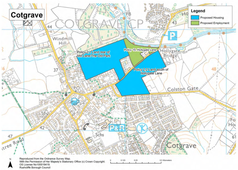
Policy 2.1 Housing Allocation – Land rear of Mill Lane/The Old Park, Cotgrave
The area, as shown on the policies map, is identified as an allocation for around 180 homes.
The development will be subject to the following requirements:
- any planning application will be required to demonstrate a sustainable layout and engineering response to the significance of archaeological remains on site as determined through a programme of intrusive archaeological evaluation. Where areas of the site are found to contain remains of such significance, or for which the costs of adequate mitigation would be prohibitive, this response should allow for their preservation;
- the amenity and privacy of neighbouring properties must be protected;
- green infrastructure should maintain and improve pedestrian linkages to the Country Park and Grantham Canal, including the safeguarding of the proposed pedestrian and cycle bridge across the canal;
- green infrastructure should achieve net-gains in biodiversity through tree planting/woodland creation;
- Ground Conditions Surveys should be undertaken to ensure neighbouring mining legacies are stable;
- surface water run-off issues must be addressed through on-site sustainable drainage measures;
- access off Hollygate Lane should be achieved through the creation of one junction that also provides access to the housing site opposite which is allocated within Policy 2.2;
- the junction at Hollygate Lane and Colston Gate must be modified. These changes should complement other changes to the highway network required within this policy and Policy 2.2;
- the junction at Hollygate Lane and Stragglethorpe Road must be modified to accommodate increased traffic resulting from this allocation and to improve junction safety;
- development must not prevent access to the site opposite which is allocated within Policy 2.2;
- a financial contribution to a package of improvements for the A52(T) between the A6005 (QMC) and A46 (Bingham); and
- it should be consistent with other relevant policies in the Local Plan.
Justification
3.16 Land rear of Mill Lane/The Old Park would form an individual site. When taking into account open space requirements on site, it is anticipated that it has capacity to accommodate around 180 dwellings, assuming the archaeologically sensitive area so far identified through geophysical survey to the western end of the site is left undeveloped to facilitate preservation of archaeology. In this respect development will require further pre-submission evaluation and the site should be approached on the basis that area(s) may need to remain undeveloped of buildings, associated groundworks, access and drainage infrastructure. In addition, overlooking of neighbouring
properties, including of bungalows, as a result of the land’s sloping topography should be avoided through sensitive site design and layout.
3.17 In accordance with Policy 8 of the Core Strategy, 10% of the new homes should be affordable homes (comprising intermediate housing, affordable rent and social rent housing). This level of affordable housing was established following consideration of local financial viability issues.
3.18 The site is within a local green infrastructure corridor and ecological corridor. It is also close to the Grantham Canal, a strategically important pedestrian and cycle route. These corridors seek to protect and enhance pedestrian and cycle connectivity between Cotgrave, the Country Park, Hollygate Park, and, in the case of the Canal, the main urban area of Nottingham and settlements to the south and east. The ecological corridor seeks to improve woodland cover and connectivity. It is important that the development of this allocation
contributes to these objectives.
3.19 As the site is located adjacent to the restored spoil tips of the former Cotgrave Colliery, the subsequent planning application on this allocation must be supported by a Ground Conditions Survey. Whilst the Council is confident that the restoration (re profiling) of these tips as a Country Park has ensured their stability, given the proximity of the allocation, these surveys would identify any risks.
3.20 The development of both allocations (covered by this policy and Policy 2.2) along Hollygate Lane would have an impact on the local highway network and in particular the junctions with Colston Gate and Stragglethorpe Road. It will need to be demonstrated that the proposed developments appropriately mitigate any potential adverse highway impacts. This mitigation should include the creation of a new road link between Colston Gate and Hollygate Lane, one single junction for both allocations, and modifications to the existing junctions of Hollygate Lane with Colston Gate and Stragglethorpe Road which improve highway safety. The development of both allocations should provide financial contributions to facilitate these junction improvements.
Policy 2.2 Housing Allocation – Land south of Hollygate Lane, Cotgrave
The area, as shown on the policies map, is identified as an allocation for around 190 homes.
The development will be subject to the following requirements:
- development must come forward as one comprehensive scheme;
- development must provide a new road connection between Colston Gate and Hollygate Lane and highway improvements at the existing Colston Gate/Hollygate Lane junction;
- access off Hollygate Lane should be achieved through the creation of one junction that also provides access to the housing site opposite which is allocated within Policy 2.1;
- the junction at Hollygate Lane and Colston Gate must be modified. These changes should complement other changes to the highway network required within this policy and Policy 2.1;
- the junction at Hollygate Lane and Stragglethorpe Road must be modified to accommodate increased traffic resulting from this allocation and to improve junction safety;
- Green Infrastructure should provide linkages to the Grantham Canal and Hollygate Park and achieve net-gains in biodiversity through tree planting and woodland creation;
- a financial contribution to a package of improvements for the A52(T) between the A6005 (QMC) and A46 (Bingham); and
- it should be consistent with other relevant policies in the Local Plan.
Justification
3.21 Land south of Hollygate Lane has a number of separate land owners but it comprises one allocation and it would be expected to be delivered as one single comprehensive development scheme, with an anticipated capacity of around 190 dwellings. The development of this allocation for housing provides an opportunity to enhance connectivity between Hollygate Park (the former Cotgrave Colliery) and the Grantham Canal, and the existing main built up area of Cotgrave. In order to accommodate development in this location at least two points of access for road traffic are likely to be required for the scheme as a whole. These could be achieved off Colston Gate and
Hollygate Lane.
3.22 The development of both allocations (covered by this policy and Policy 2.1) along Hollygate Lane would have an impact on the local highway network and in particular the junctions with Colston Gate and Stragglethorpe Road. It will need to be demonstrated that the proposed developments appropriately mitigate any potential adverse highway impacts. This mitigation should include the creation of a new road link between Colston Gate and Hollygate Lane, one single junction for both allocations, and modifications to the existing junctions of Hollygate Lane with Colston Gate and Stragglethorpe Road which improve highway safety. The development of both allocations should provide financial contributions to facilitate these junction improvements.
3.23 In accordance with Policy 8 of the Core Strategy, 10% of the new homes should be affordable homes (comprising intermediate, affordable rent and social rent housing). This level of affordable housing was established following the consideration of local financial viability issues.
3.24 The site is within a local green infrastructure corridor and ecological corridor. It is also close to the Grantham Canal, a strategically important pedestrian and cycle route. These corridors seek to protect and enhance pedestrian and cycle connectivity between Cotgrave, the Country Park, Hollygate Park, and, in the case of the Canal, the main urban area of Nottingham and settlements to the south and east. The ecological corridor seeks to improve woodland cover and connectivity. It is important that the development of this allocation
contributes to these objectives.
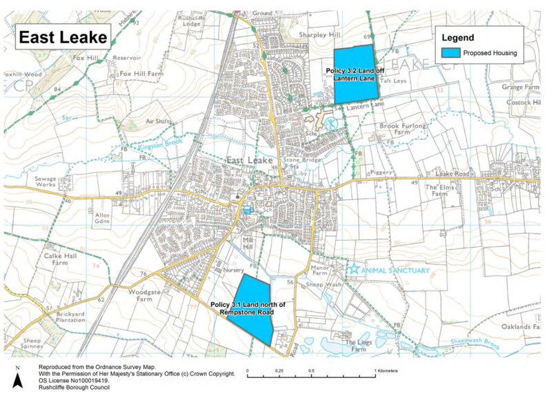
Housing Allocations at East Leake
3.25 The Core Strategy sets a minimum target of 400 new homes that need to be built on new greenfield sites at East Leake up to 2028. Planning permission has recently been granted on ten greenfield sites around the village that will deliver around 1,200 new homes in total. All of the homes count towards the minimum 400 home target, which means it has already been exceeded by around 800 homes.
3.26 It is considered that it would be unacceptable to identify further land at East Leake for housing development over the plan period. To do so would put at risk the Core Strategy’s focus to locate development within or adjacent to the main urban area of Nottingham. There are also concerns over East Leake’s capacity to support and assimilate additional housing at this time and the affect that any further development would have on the character of the village. This Local Plan Part 2 allocates two sites for housing development at
East Leake on land to the north of Rempstone Road and the second on land north of Lantern Lane (see Figure 2). Both these sites are outside the existing built extent of the village and both already have planning permission for new housing but development has yet to start.
Policy 3.1 Housing Allocation – Land north of Rempstone Road, East Leake
The area, as shown on the policies map, is identified as an allocation for around 235 homes.
The development will be subject to the following requirements:
- if required, a serviced site within the north of the allocation should be provided for a new primary school;
- appropriate financial contributions for new primary school and medical centre provision where necessary;
- pedestrian and cycling access to the centre of East Leake should utilise the existing footpath through the site and opportunities to integrate the allocation with the neighbouring Kirk Ley development;
- development on the Rempstone Road frontage and which borders the open countryside should provide a visually attractive gateway and boundary to the village; and
- it should be consistent with other relevant policies in the Local Plan.
Justification
3.27 In accordance with Policy 8 of the Core Strategy, 20% of the new homes should be affordable homes (comprising intermediate, affordable rent and social rent housing). This level of affordable housing was established following the consideration of local financial viability issues.
3.28 Due to existing inadequate school capacity and the additional demand for school places that would be generated by the development of this allocation (and other sites at East Leake), an accessible serviced site may be required for a new-one form entry primary school within the allocation. In order to ensure these facilities are in the most accessible location for the majority of residents, land within the north of the site, closer to village, should be safeguarded as the location for the new primary school. In accordance with
the extant outline planning permission, the school must be a accessed off Kirk Ley Road, through the neighbouring development.
Proposed housing at:
- Land north of Rempstone Road
- Land off Lantern Lane
3.29 Whilst vehicular access for residents will be achieved off Rempstone Road, given the distance from the centre of the village, more direct non-motorised access must be provided through the neighbouring development off Kirk Ley Road and via the existing right of way from Rempstone Road, through the site and into the village.
3.30 The allocation is in a prominent location on Rempstone Road and it extends into the open countryside. It is therefore important that the design and layout of the development on the frontage provides a visually attractive entrance to the village. Development adjacent to the open countryside should respect the rural character of the area.
Policy 3.2 Housing Allocation – Land off Lantern Lane, East Leake
The area, as shown on the policies map, is identified as an allocation for around 195 homes.
The development will be subject to the following requirements:
- in order to reduce landscape and visual impacts elevated land to the north and east should comprise a multi-functional green-infrastructure buffer between the development and open countryside;
- the right of way which crosses the site from Lantern Lane should be preserved, forming a pedestrian corridor to the open countryside;
- a detailed geotechnical and mining study should be undertaken to ensure an acceptable buffer between gypsum mining operations and the development can be established; and
- it should be consistent with other relevant policies in the Local Plan.
Justification
3.31 The allocation is situated on land which rises to the north and east towards a low ridge that encloses this area of the village. Consequently, in order to avoid wider landscape and visual impacts, the built development should be restricted to lower elevations within the site.
3.32 The allocation is located 1km south of the British Gypsum Mine and subterranean extraction of Gypsum has extended under the northern boundary of the allocation. In order to ensure properties are not at risk of subsidence, resulting from the collapse of these workings, a suitable buffer around this area should be established.
3.33 In accordance with Policy 8 of the Core Strategy, 20% of the new homes should be affordable homes (comprising intermediate, affordable rent and social rent housing). This level of affordable housing was established following the consideration of local financial viability issues.
Housing Allocations in Keyworth
3.34 The Core Strategy sets a target of a minimum of 450 new homes that need to be built on greenfield sites at Keyworth up to 2028. It is considered that Keyworth has scope to sustain around 600 dwellings in total on greenfield sites adjacent to the village.
3.35 For instance, the new health centre has scope to accommodate this level of development subject potentially to developer contributions to support improvements. It is also judged that, given the existing size of the town which has around 3,000 dwellings, around 600 new homes should be able to be assimilated as part of Keyworth without unduly affecting the village’s character or local amenity.
3.36 In balancing housing requirements across Rushcliffe to 2028, sustainability, Green Belt, settlement capacity and other relevant planning considerations, the following sites (see Figure 3) have been identified as housing allocations and have been removed from the Green Belt:
- Land off Nicker Hill;
- Land between Platt Lane and Station Road;
- Land south of Debdale Lane; and
- Hillside Farm.
3.37 With the exception of Hillside Farm, the sites are identified as recommended housing allocations within the Keyworth Neighbourhood Plan.
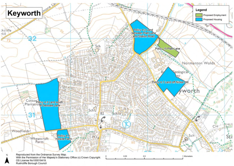
Policy 4.1 Housing Allocation – Land off Nicker Hill, Keyworth
The area, as shown on the policies map, is identified as an allocation for around 150 homes.
The development will be subject to the following requirements:
- Green Infrastructure should improve connections to the right of way network and deliver net-gains in biodiversity;
- improvements to the junction of Platt Lane, Nicker Hill, Normanton Lane and Station Road to reduce speeds and increase visibility;
- significant impacts on the amenity of new residents resulting from the activities of the neighbouring British Geological Survey, that may also result in unreasonable restrictions on this business’s activities, should be avoided or adequately mitigated;
- a financial contribution to a package of improvements for the A52(T) between the A6005 (QMC) and A46 (Bingham); and
- it should be consistent with other relevant policies in the Local Plan.
Justification
3.38 In accordance with Policy 8 of the Core Strategy, 20% of the new homes should be affordable homes (comprising intermediate, affordable rent and social rent housing). This level of affordable housing was established following the consideration of local financial viability issues.
3.39 The site is within a local green infrastructure corridor. This corridor seeks to protect and enhance pedestrian connectivity east of Keyworth, towards Normanton on the Wolds and beyond to Cotgrave.
3.40 The neighbouring British Geological Survey (BGS) is identified as a Centre of Excellence within Policy 5 of the Core Strategy. Given the proximity of the allocation to this facility new residents should not be adversely affected by noise, dust or odours which may subsequently restrict the BGS’s operations and lead to the relocation of this establishment. Policy 4.1 therefore requires proposals on this site to include comprehensive avoidance and mitigation measures, in order prevent adverse impacts on the amenity of neighbouring
residents.
Policy 4.2 Housing Allocation – Land between Platt Lane and Station Road, Keyworth
The area, as shown on the policies map, is identified as an allocation for around 190 homes.
The development will be subject to the following requirements:
- there should be two points of vehicle access, off Platt Lane and Station Road;
- carriageway and crossing improvements to Platt Lane including the delivery of appropriate safe footpaths on either side of the road;
- improvements to the junction of Platt Lane, Nicker Hill, Normanton Lane and Station Road to reduce speeds and increase visibility;
- Green infrastructure should deliver net-gains in biodiversity through tree planting which complements other green infrastructure objectives;
- subject to access requirements, the hedgerow on Platt Lane and tree belt on Station Road must be retained;
- Green infrastructure should include a suitable buffer with the neighbouring sports facility in order to protect the amenity of residents and users of the right of way;
- mitigation measures should be installed as appropriate on the north-east boundary to protect dwellings from damage from the adjacent sports facility;
- a financial contribution to a package of improvements for the A52(T)
between the A6005 (QMC) and A46 (Bingham); and - it should be consistent with other relevant policies in the Local Plan.
Justification
3.41 In accordance with Policy 8 the Core Strategy, 20% of the new homes should be affordable homes (comprising intermediate, affordable rent and social rent housing). This level of affordable housing was established following the consideration of local financial viability issues.
3.42 The site is within a local green infrastructure corridor. This corridor seeks to protect and enhance pedestrian connectivity east of Keyworth, towards Normanton on the Wolds and beyond to Cotgrave. It also encourages net-gains in biodiversity through increases in tree cover and the ecological connectivity of woodland sites.
3.43 The site is located adjacent to a cricket pitch and therefore an assessment should be carried out and, if appropriate, mitigation measures should be installed along the boundary between this housing allocation and the sports facility. This would be to protect the new dwellings from possible damage from cricket balls.
Policy 4.3 Housing Allocation – Land south of Debdale Lane, Keyworth
The area, as shown on the policies map, is identified as an allocation for around 190 homes.
The development will be subject to the following requirements:
- pedestrian and cycle access should be achieved via Croft Road;
- Green Infrastructure will include a landscape buffer along the site’s western boundary;
- the two northern fields (adjacent to Debdale Lane) remain in the Green Belt and should comprise a landscape buffer and multifunctional open space;
- a financial contribution to a package of improvements for the A52(T)
between the A6005 (QMC) and A46 (Bingham); and - it should be consistent with other relevant policies in the Local Plan.
Justification
3.44 In accordance with Policy 8 of the Core Strategy, 20% of the new homes should be affordable homes (comprising intermediate, affordable rent and social rent housing). This level of affordable housing was established following the consideration of local financial viability issues.
3.45 Due to the site’s elevated location and subsequent landscape and visual intrusion, green infrastructure should provide a landscape buffer in order to reduce the development’s visual intrusion. Particularly when viewed from the west and from the north.
3.46 The two northern fields which slope steeply down towards Debdale Lane, a small stream and a right of way remain in the Green Belt. Inappropriate built development within these fields will be restricted and the land utilised as publicly accessible open space. Where appropriate these fields should provide play space, a landscape buffer, improved wildlife habitats, and deliver pedestrian and cycle connectivity to Debdale Lane and the rights of way network which connect the site to the wider countryside.
Policy 4.4 Housing Allocation – Hillside Farm, Keyworth
The area, as shown on the policies map, is identified as an allocation for around 70 homes.
The development will be subject to the following requirements:
- the amenity of residents should not be significantly affected by noise, odour or dust resulting from the activities of the neighbouring farm;
- the continuation of agricultural operations within the neighbouring farm should not be prejudiced as a result of adverse effects on the amenity of residents;
- a financial contribution to a package of improvements for the A52(T) between the A6005 (QMC) and A46 (Bingham); and
- it should be consistent with other relevant policies in the Local Plan.
Justification
3.47 In accordance with Policy 8 of the Core Strategy, 20% of the new homes should be affordable homes (comprising intermediate, affordable rent and social rent housing). This level of affordable housing was established following the consideration of local financial viability issues.
3.48 Given the allocation’s location adjacent to an operational farm, the amenity of new residents should not be adversely affected by noise, dust or odours which may subsequently restrict the farm’s operations. Policy 4.4 therefore requires proposals on this site include comprehensive avoidance measures, including a buffer, in order prevent adverse impacts on the amenity of neighbouring residents.
Housing Allocations at Radcliffe on Trent
3.49 The Core Strategy sets a target of a minimum of 400 new homes that need to be built on greenfield sites within the existing Green Belt surrounding Radcliffe on Trent up to 2028.
3.50 A critical constraint influencing new housing numbers at Radcliffe on Trent is the limited primary school capacity and limited scope to expand existing school premises. It may therefore be necessary for new housing to be accompanied by a new primary school. Should a new primary school be required, one of the allocated sites will need to provide a serviced plot for the school. To generate the pupil numbers required to sustain a new one-form entry primary school and to also generate sufficient developer contributions to
cover the costs of a new school, it would require the delivery of upwards of 1,000 new homes on the edge of Radcliffe on Trent.
3.51 In addition the existing medical centre may not be capable of expansion and may not be able to accommodate the needs generated by the new housing. Therefore land should also be made available for a serviced plot for a new medical centre in case this is needed as an alternative site.
3.52 In balancing housing requirements across Rushcliffe to 2028, sustainability, Green Belt, settlement capacity, flood risk, the availability of suitable sites for development and other relevant planning considerations, that the following sites (see Figure 4) are identified as housing allocations and have been removed, where applicable, from the Green Belt to deliver around 970 new homes:
- Land north of Nottingham Road;
- Land adjacent Grooms Cottage;
- Land off Shelford Road;
- Land north of Grantham Road to south of railway line;
- 72 Main Road; and
- The Paddocks, Nottingham Road.
3.53 In the event that new sites are required for a primary school and/or medical centre due to new housing development, land off Shelford Road is identified as the preferred location for both within Policy 5.3.
3.54 It would be expected that all the sites would contribute financially and equitably to the provision of a new primary school and medical centre for the village.
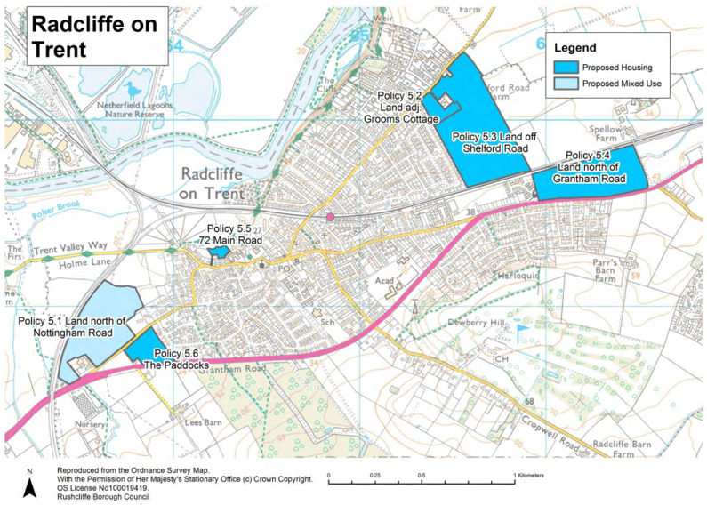
Policy 5.1 Housing Allocation – Land north of Nottingham Road, Radcliffe on Trent
The area, as shown on the policies map, is identified as an allocation for between 150 and around 200 homes and a minimum of 3 hectares of employment.
The development will be subject to the following requirements:
- land identified within the allocation on policies map will be developed for employment uses (B1, B2 and B8);
- vulnerable development within flood zone 3 (within a small area of the site’s south western corner) must be avoided;
- a site specific flood risk assessment (FRA) should ensure the site is not affected by current or future flooding and it does not increase flood risks elsewhere;
- Green Infrastructure should improve connections to the rights of way network, including the neighbouring former Cotgrave Colliery Mineral Line (a pedestrian and cycle route), deliver net-gains in biodiversity and where necessary contribute to flood risk avoidance measures;
- appropriate financial contributions towards education and health capacity improvements to support development;
- a financial contribution to a package of improvements for the A52(T) between the A6005 (QMC) and A46 (Bingham); and
- it should be consistent with other relevant policies in the Local Plan.
Justification
3.55 Policy 5.1 (Land north of Nottingham Road) will include an element of employment land to form a mixed development. The adopted Radcliffe on Trent Neighbourhood Plan identifies a local community desire for a balance of new and revitalised employment to support housing growth at Radcliffe on Trent.
3.56 The land allocated under Policy 5.1 provides such an opportunity given its western location close to the main Nottingham urban area, its accessibility to the A52, its low lying topography and the benefits that the former minerals railway line embankment along the western edge of the site would provide in terms of screening future development and increasing pedestrian and cycle access.
3.57 The allocation is divided by overhead power lines which cross the site in a north-south direction. It is logical for employment to be located to the western side of the power lines and housing predominately to the east, with development appropriately set back from the power lines on each side. The development of employment should be focused adjacent to the existing RSPCA Animal Shelter as this will to help avoid potential conflict between it and areas of housing. The development scheme should also avoid locating more vulnerable residential development within the flood zone 3 area.
3.58 In accordance with Policy 8 of the Core Strategy, 30% of the new homes should be affordable homes (comprising intermediate, affordable rent and social rent housing). This level of affordable housing was established following the consideration of local financial viability issues.
3.59 As the land is within flood zone 2 and contains a small area within flood zone 3, the allocation was subject to the sequential test during the plan making process. The sequential test ensures that reasonable alternative allocations, which are at a lower risk of flooding (in this case, those within flood zone 1), are allocated instead.
3.60 The sequential test determined that as the allocation provides for employment land and it is in a more sustainable location for mixed use development, it was sequentially preferable to the alternative allocations. In accordance with the National Planning Policy Framework and National Planning Policy Guidance, as residential development is a more vulnerable use, when located within flood zone 2, any forthcoming proposal must be supported by a flood risk assessment which establishes that the development will not be affected
by current and future flooding and it does not increase flood risk elsewhere.
3.61 As identified in Appendix D, the allocation is located within the River Trent Green Infrastructure Corridor, Urban Fringe area and is adjacent to the former Cotgrave Colliery Mineral Line, which is now a pedestrian and cycle route between Cotgrave and Radcliffe on Trent. It is also located within the River Trent Ecological Network, which comprises wetlands, grasslands and woodland. In accordance with Policies 35 and 38 the development of this allocation should incorporate green infrastructure which connects to the former minerals line and the local rights of way network (including the Trent Valley Way along Holme Lane). It should also achieve net-gains in biodiversity through the preservation and creation of connected habitats, including where appropriate wetlands, woodland and grassland.
Policy 5.2 Housing Allocation – Land adjacent Grooms Cottage, Radcliffe on Trent
The area, as shown on the policies map, is identified as an allocation for around 50 homes.
The development will be subject to the following requirements:
- development should complement and not prejudice the delivery of the neighbouring site which is allocated within Policy 5.3;
- sensitive boundary treatment should protect the amenity of existing neighbouring properties;
- appropriate financial contributions towards education and health capacity improvements to support development;
- a financial contribution to a package of improvements for the A52(T) between the A6005 (QMC) and A46 (Bingham); and
- it should be consistent with other relevant policies in the Local Plan.
Justification
3.62 In accordance with Policy 8 of the Core Strategy, 30% of the new homes should be affordable homes (comprising intermediate, affordable rent and social rent housing). This level of affordable housing was established following the consideration of local financial viability issues.
3.63 The site is bounded by land that is allocated for housing development under Policy 5.3 and which also provides land for the new primary school and health centre, both of which may be required to meet demand generated by new housing at Radcliffe on Trent. These could be located close to Shelford Road and the development of this allocation should not prevent the delivery of these important facilities or the neighbouring new homes. Particular attention should be paid to the amenity of residents, highways and access issues, and the pedestrian and cycling connectivity of these sites.
3.64 The development of this allocation, together with the allocation contained within Policy 5.3, should not prejudice the delivery of either site. In particular, there are no surface water or combined sewers in the vicinity of this site. Given the topography of the area, if surface water issues cannot be adequately managed within this allocation, surface water drainage solutions may have to be in place within the adjacent allocation (Policy 5.3) before the development of this allocation in order to allow appropriate drainage to be
provided in accordance with the drainage hierarchy.
Policy 5.3 Housing Allocation – Land off Shelford Road, Radcliffe on Trent
The area, as shown on the policies map, is identified as an allocation for around 400 homes.
The development will be subject to the following requirements:
- a serviced site(s) within the north of the allocation should be provided for a new one form entry primary school and medical centre;
- appropriate financial contributions towards education and health capacity improvements to support development;
- land within the south of the site should be safeguarded for a future pedestrian and cycling bridge across the railway line;
- development should complement and not prejudice the delivery of the neighbouring site which is allocated within Policy 5.2;
- sensitive boundary treatments should protect the amenity of existing neighbouring properties;
- a financial contribution to a package of improvements for the A52(T) between the A6005 (QMC) and A46 (Bingham); and
- it should be consistent with other relevant policies in the Local Plan.
Justification
3.65 The Local Education Authority and Clinical Commission Group have concerns regarding the capacity of existing educational and health facilities within Radcliffe on Trent. If existing educational and health facilities cannot be expanded to meet existing demand, land off Shelford Road is identified as the preferred location for the new primary school and medical centre. In order to ensure these facilities are in the most accessible location for the majority of residents, land within the north of the site, closer to Shelford Road, should be
safeguarded as the location for the new primary school and medical centre. If increased demand can be met without requiring a new school or medical centre, the land required under policy 5.3 (part a) can be developed for other uses.
3.66 Whilst a financial contribution for the primary school and medical centre is likely to be required, as the owner/developer of this site may be required to provide the land for these facilities, they will not be expected to provide the same level of financial contributions (per dwelling) as the owner/developers of the other four allocations identified on the edge of Radcliffe on Trent. Until the adoption of the Community Infrastructure Levy, individual financial contributions will be established during the determination of each allocation’s
subsequent planning application.
3.67 The development of this site offers an opportunity to link this area of Radcliffe on Trent (which may include a new primary school and medical centre) with areas of the village on the opposite side of the railway line, which are only accessible via a detour through the centre of the village. In order to ensure this potential link is not jeopardised by development, land adjacent to the railway line should be safeguarded.
3.68 In accordance with Policy 8 of the Core Strategy, 30% of the new homes should be affordable homes (comprising intermediate, affordable rent and social rent housing). This level of affordable housing was established following the consideration of local financial viability issues.
3.69 The development of this allocation, together with the allocation contained within Policy 5.2, should not prejudice the delivery of either site. In particular, there are no surface water or combined sewers in the vicinity of this site. Given the topography of the area, if the neighbouring allocation cannot adequately manage its own surface water, drainage solutions for this allocation should be capable of allowing for the development of the allocation contained within Policy 5.2, in accordance with the drainage hierarchy.
Policy 5.4 Housing Allocation – Land north of Grantham Road, Radcliffe on Trent
The area, as shown on the policies map, is identified as an allocation for around 240 homes.
The development will be subject to the following requirements:
- the existing junction off the A52 to the business park will, subject to required improvements, provide the primary access to the site;
- development on the A52 frontage and which borders the open countryside should provide a visually attractive gateway and boundary to the village;
- land within the west of the site should be safeguarded for a future pedestrian and cycling bridge across the railway line;
- occupants should not be adversely affected by noise;
- appropriate financial contributions towards education and health capacity improvements to support development;
- a financial contribution to a package of improvements for the A52(T) between the A6005 (QMC) and A46 (Bingham); and
- it should be consistent with other relevant policies in the Local Plan.
Justification
3.70 In accordance with Policy 8 of the Core Strategy, 30% of the new homes should be affordable homes (comprising intermediate, affordable rent and social rent housing). This level of affordable housing was established following the consideration of local financial viability issues.
3.71 The site is located adjacent to the A52, an important trunk road which links the A1 to Nottingham. Direct access onto the A52 will be required and this should be achieved via the business park access road and its junction with the A52. Located on the eastern boundary, the junction may, subject to advice from Highways England, require modifications which would be funded by the development.
3.72 Due to the allocation’s position between the A52 and railway line, residential amenity may be adversely affected by the noise of trains and vehicles. If necessary, avoidance measures, including vegetation buffers, should be incorporated into the layout and design of the development. 3.73 The allocation is in a prominent location on the approach to Radcliffe on Trent along the A52 and it extends into the open countryside, beyond the existing residential area opposite at Harlequin. It is therefore important that the design and layout of the development on the frontage with the A52 and at the junction with the business park provides a visually attractive entrance to the
village. Development adjacent to the open countryside should respect the rural character of the area.
Policy 5.5 Housing Allocation – 72 Main Road, Radcliffe on Trent
The area, as shown on the policies map, is identified as an allocation for around 5 homes.
Justification
3.74 Although the site in terms of its size could accommodate 10 to 15 new homes, given the single track access to the site, the number of homes within this allocation is restricted to around 5 homes.
Policy 5.6 Housing Allocation – The Paddocks, Nottingham Road, Radcliffe on Trent
The area, as shown on the policies map, is identified as an allocation for around 75 homes.
The development will be subject to the following requirements:
- occupants should not be adversely affected by noise disturbance caused by traffic on the A52;
- any surface water drainage issues should be managed by effective sustainable drainage systems;
- appropriate financial contributions towards education and health capacity improvements to support development;
- a financial contribution to a package of improvements for the A52(T) between the A6005 (QMC) and A46 (Bingham); and
- it should be consistent with other relevant policies in the Local Plan.
Justification
3.75 In accordance with Policy 8 of the Core Strategy, 30% of the new homes should be affordable homes (comprising intermediate, affordable rent and social rent housing). This level of affordable housing was established following the consideration of local financial viability issues.
Housing Allocation at Ruddington
3.76 The Core Strategy sets a target of a minimum of 250 new homes that need to be built on greenfield sites at Ruddington up to 2028. It is considered that Ruddington has scope to sustain around 525 dwellings in total adjacent to the village, based on the capacity of local services and the availability of suitable sites for development.
3.77 In balancing sustainability, Green Belt, settlement capacity, heritage, flood risk and other relevant planning considerations, the following sites (see Figure 5) are identified as housing allocations and have been removed from the Green Belt:
- Land to the west of Wilford Road;
- Land south of Flawforth Lane;
- Land opposite Mere Way; and
- Land north of Asher Lane.
3.78 All three sites are located on the edge of Ruddington and can be accessed either off the A60 or Wilford Road. In these locations, residents who commute to Nottingham or south and choose to drive can access their employment without travelling through the centre of the village, which, due to its historical layout, is congested at peak times.
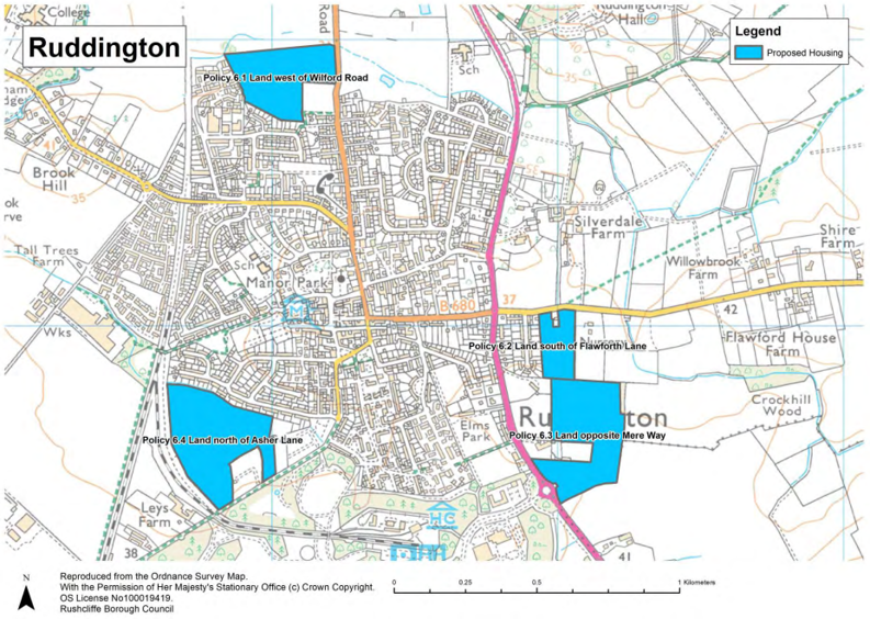
Policy 6.1 Housing Allocation – Land west of Wilford Road, Ruddington
The area, as shown on the policies map, is identified as an allocation for around 130 homes.
The development will be subject to the following requirements:
- vulnerable development should not be located within flood zone 3;
- a site specific flood risk assessment (FRA) should demonstrate that the development will be flood resilient and resistant and safe for its lifetime for its users and also ensure the site is not affected by current or future flooding and it does not increase flood risks elsewhere or overall;
- development on the Wilford Road frontage and which borders the open countryside should provide a visually attractive gateway and boundary to the village;
- on-site green infrastructure should deliver recreational open spaces, landscape buffers (including a buffer around Sellers Field Recreation Ground), net-gains in biodiversity and where necessary surface water flood mitigation. This should include a 10 metre buffer either side of the Packman Dyke;
- a financial contribution to a package of improvements for the A52(T) between the A6005 (QMC) and A46 (Bingham); and
- it should be consistent with other relevant policies in the Local Plan.
Justification
3.79 As the land contains significant areas within flood zone 2 and also a smaller area within flood zone 3 (adjacent to Packman Dyke and Wilford Road), the allocation was subject to the sequential test during the plan making process. The sequential test ensures that reasonable alternative allocations, which are at a lower risk of flooding (in this case, those within flood zone 1), are allocated instead.
3.80 The sequential test determined that no reasonable alternative sites are preferable to this allocation (having compared the sustainability of the sites and determining they are not reasonable alternatives). However, in accordance with the National Planning Policy Framework and National Planning Policy Guidance, as residential development is a more vulnerable use, when located within flood zone 2, any forthcoming proposal must be supported by a flood risk assessment which establishes that the development will not be affected by current and future flooding and it does not increase flood risk elsewhere.
3.81 The allocation is located within a prominent position on the approach to Ruddington along Wilford Road and extends into the open countryside. It is therefore important that the design and layout of the development on the frontage with Wilford Road and open countryside to the north provides a visually attractive entrance to the village. Development adjacent to the open countryside should respect the rural character of the area.
3.82 The allocation is located within the Fairham Brook and Packman Dyke Green Corridor which provides flood risk mitigation, contains priority habitat (including the designated Fairham Brook Nature Reserve and Wilwell Cutting Site of Special Scientific Interest), provides their ecological connectivity, contains recreational opportunities and pedestrian and cycling connectivity (particularly south of Ruddington within and adjacent to the Country Park). Within the site multi-functional green infrastructure should deliver recreational
spaces and net-gains in biodiversity (comprising where appropriate new wetland, grassland and woodland). Critically, the ecological and surface water functions of Packman Dyke and its environs must be preserved and enhanced within a 10 metre wide buffer.
3.83 In accordance with Policy 8 of the Core Strategy, 30% of the new homes should be affordable homes (comprising intermediate, affordable rent and social rent housing). This level of affordable housing was established following the consideration of local financial viability issues.
Policy 6.2 Housing Allocation – Land south of Flawforth Lane, Ruddington
The area, as shown on the policies map, is identified as an allocation for around 50 homes.
The development will be subject to the following requirements:
- the trees and hedgerows which form the boundary of the site should be retained;
- the setting of the Conservation Area and Grade II Listed Easthorpe House should be preserved;
- a financial contribution to a package of improvements for the A52(T) between the A6005 (QMC) and A46 (Bingham); and
- it should be consistent with other relevant policies in the Local Plan.
Justification
3.84 Established trees and vegetation form the boundary of the site, most notably the frontage on Flawforth Lane and the boundary with Flawforth Avenue. These trees contribute to the character of the area and their retention would contribute to the landscape buffer (preserving the rural character of the area, including the Conservation Area) and reduce adverse effects on the amenity of neighbouring properties.
3.85 As Ruddington’s Conservation Area is located adjacent to the site’s southern boundary and it comprises, in this locality, extensive grounds to a private property, the development of this allocation should be set back at this point and the hedgerow enhanced in order to preserve the character of this part of the conservation area.
3.86 In accordance with Policy 8 of the Core Strategy, 30% of the new homes should be affordable homes (comprising intermediate, affordable rent and social rent housing). This level of affordable housing was established following the consideration of local financial viability issues.
Policy 6.3 Housing Allocation – Land opposite Mere Way, Ruddington
The area, as shown on the policies map, is identified as an allocation for around 170 homes.
The development will be subject to the following requirements:
- the existing roundabout at the Mere Way/A60 junction will provide road access;
- the setting of the Conservation Area should be preserved;
- development along the Loughborough Road frontage, at the junction with Mere Way and which borders the open countryside should provide a visually attractive gateway and boundary to the village;
- a financial contribution to a package of improvements for the A52(T) between the A6005 (QMC) and A46 (Bingham); and
- it should be consistent with other relevant policies in the Local Plan.
Justification
3.87 The allocation is located at the Mere Way/A60 roundabout, this is a prominent gateway on the approach to Ruddington on the A60 (Loughborough Road). It is therefore important that the design and layout of the development on the frontage with the A60 and at the junction with Mere Way provides a visually attractive entrance to the village. Parts of the western boundary of the site are adjacent to the Ruddington Conservation Area. This boundary largely consists of mature hedgerow. This boundary should be enhanced, and
development set back from it in order to protect the setting of the conservation area. Development on the southern and eastern boundaries, adjacent to the open countryside, should respect the rural character of the area.
3.88 In accordance with Policy 8 of the Core Strategy, 30% of the new homes should be affordable homes (comprising intermediate, affordable rent and social rent housing). This level of affordable housing was established following the consideration of local financial viability issues.
Policy 6.4 Housing Allocation – Land north of Asher Lane, Ruddington
The area, as shown on the policies map, is identified as an allocation for around 175 homes.
The development will be subject to the following requirements:
- Asher Lane must be brought up to adoptable highway standard, including the provision of a footpath along its entire length;
- appropriate junction Improvements including traffic signals to the High Street / Kirk Lane / Charles Street junction and the A60 / Kirk Lane / Flawforth Lane junction;
- mitigation of on-street car parking on Asher Lane, between Musters Road and Distillery Street;
- existing trees and hedges must be retained;
- a financial contribution to a package of improvements for the A52(T) between the A6005 (QMC) and A46 (Bingham); and
- it should be consistent with other relevant policies in the Local Plan.
Justification
3.89 The allocation is situated on the southern edge of Ruddington and can only be accessed through the village centre, via the High Street or Church Street and The Green. Consequently impacts on the local highway network are significant issues and the highway improvement measures outlined within the policy must be delivered alongside the development of the allocation.
3.90 In accordance with Policy 8 of the Core Strategy, 30% of the new homes should be affordable homes (comprising intermediate, affordable rent and social rent housing). This level of affordable housing was established following the consideration of local financial viability issues.
Housing Allocation at Cropwell Bishop
3.91 Cropwell Bishop has capability to sustain around 70 dwellings on greenfield sites adjacent to the village, based on the existing size and status of the settlement, the capacity of local services and the size of those sites deemed most suitable for housing development.
3.92 In balancing housing requirements across Rushcliffe to 2028, sustainability, Green Belt, settlement capacity and other relevant planning considerations, land east of Church Street (see Figure 6) is identified as a housing allocation and has been removed from the Green Belt.
Policy 7 Housing Allocation – Land east of Church Street, Cropwell Bishop
The area, as shown on the policies map, is identified as an allocation for around 70 homes.
The development will be subject to the following requirements:
- a new junction comprising a mini roundabout on Church Street will provide access to the site and an additional access and parking for the neighbouring primary school;
- on-site multi-functional green infrastructure should provide a buffer between the new homes and sewage treatment works;
- the right of way along the allocation’s eastern and southern boundaries must be retained as part of multi-functional green infrastructure buffers which retain the existing rights of way and provide a visually attractive settlement edge;
- the completion of archaeological surveys prior to the submission of any planning applications; and
- it should be consistent with other relevant policies in the Local Plan.
Justification
3.93 The allocation of this land offers an opportunity to provide a new access and parking for the existing primary school, which is adjacent to the site. The current access to the school, via Stockwell Lane, is not suitable for this purpose and roads in the vicinity of the school are congested at peak times. An additional access off Church Street and parking adjacent to the school site would alleviate these issues and provide a safer environment for pupils and their families.
3.94 The site is bounded by public footpaths to the south and east, and by the sewage treatment works to the north. The delivery of multi-functional green infrastructure along these boundaries, which retain and improve rights of way and publicly accessible open space, deliver net-gains in biodiversity, manage surface water run-off and create a visually attractive settlement edge, should be incorporated into the design and layout of the proposal.
3.95 Historical records indicate that archaeological remains of the old historic core of the village may be present within the western area of the allocation, closer to Church Street. Archaeological investigation of the site must be undertaken to establish whether any important archaeological features remain and to inform, if necessary, any mitigation that may be required as a result of the investigations.
3.96 In accordance with Policy 3 of the Core Strategy, 30% of the new homes should be affordable homes (comprising intermediate, affordable rent and social rent housing). This level of affordable housing was established following the consideration of local financial viability issues.
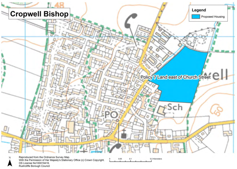
Housing Allocations at East Bridgford
3.97 East Bridgford has scope to sustain around 125 dwellings on greenfield sites adjacent to the village, based on the existing size and status of the settlement, the capacity of local services and the size of those sites deemed suitable for housing development.
3.98 In balancing housing requirements across Rushcliffe to 2028, sustainability, Green Belt, settlement capacity and other relevant planning considerations, the following sites (see Figure 7) are identified as housing allocations and have been removed from the Green Belt:
- Land between Butt Lane and Closes Side Lane; and
- Land south of Butt Lane.
Policy 8.1 Housing Allocation – Land between Butt Lane and Closes Side Lane, East Bridgford
The area, as shown on the policies map, is identified as an allocation for around 80 homes.
The development will be subject to the following requirements:
- development must come forward as one comprehensive scheme;
- an access road connecting Butt Lane and Closes Side Lane must be provided through the site;
- the development of this allocation should not prejudice the delivery of Land south of Butt Lane which is allocated for residential development within Policy 8.2;
- frontage development on Butt Lane should complement the design of the residential development opposite, which is allocated within Policy 8.2, and not detract from the character of Butt Lane as a rural approach to the village or affect the setting of the Conservation Area;
- development which borders the open countryside to the east should provide a visually attractive boundary that respects the area’s rural character;
- the right of way from Holloway Close, through the site, should be preserved, forming a pedestrian corridor to the open countryside; and it should be consistent with other relevant policies in the Local Plan.
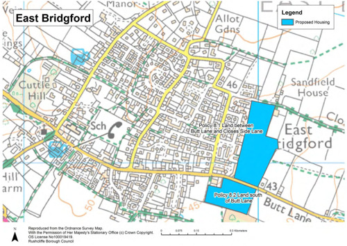
Justification
3.99 Land between Butt Lane and Closes Side Lane has a number of separate land owners but it comprises one allocation and it would be expected to be delivered as one single comprehensive development scheme, with an anticipated capacity of around 80 dwellings.
3.100 The allocation of the land for development offers an opportunity to provide an alternative link between Butt Lane and Closes Side Lane, which would reduce traffic on the existing route via Cross Lane. It would also mirror the historical layout of north/south and east/west arterial routes through East Bridgford.
3.101 This allocation extends into the open countryside on the north side of Butt Lane, a road which provides an attractive rural approach to East Bridgford. The development of this site should ensure that the rural character of the area is preserved, as far as is possible, through sensitive frontage development on Butt Lane and along those boundaries with the open countryside. Critically the design and layout of the development’s frontages should complement development on the opposite side of Butt Lane.
3.102 In accordance with Policy 8 of the Core Strategy, 30% of the new homes should be affordable homes (comprising intermediate, affordable rent and social rent housing). This level of affordable housing was established following the consideration of local financial viability issues.
Policy 8.2 Housing Allocation – Land south of Butt Lane, East Bridgford
The area, as shown on the policies map, is identified as an allocation for around 45 homes.
The development will be subject to the following requirements:
- additional parking for the neighbouring medical centre should be provided;
- frontage development on Butt Lane should complement the design of the residential development opposite, which is allocated within Policy 8.1, and not detract from the character of Butt Lane as a rural approach to the village, or affect the setting of the Conservation Area;
- the development of this allocation should not prejudice the delivery of the site opposite which is allocated within Policy 8.1;
- development which borders the open countryside to the east should be screened by a substantial tree belt which connects Butt Lane and the neighbouring Millennium Wood;
- the right of way which connects Butt Lane and Millennium Wood should be retained; and
- it should be consistent with other relevant policies in the Local Plan.
Justification
3.103 The absence of sufficient parking for patients attending the medical centre has resulted in on-street parking on Butt Lane and neighbouring streets. The allocation of this site offers an opportunity to provide additional parking adjacent to the medical centre.
3.104 This allocation extends into the open countryside on the south side of Butt Lane, a road which provides an attractive rural approach to East Bridgford. The development of this site should ensure that the rural character of the area is preserved, as far as is possible, through sensitive frontage development on Butt Lane and along those boundaries with the open countryside. Critically the design and layout of the development frontages should complement the development on the opposite side of Butt Lane.
3.105 A substantial tree buffer along the site’s eastern boundary would reduce the landscape and visual impacts of the development when viewed from the east and provide an extension of Millennium Wood, an area of deciduous woodland, which is a priority habitat.
3.106 In accordance with Policy 8 of the Core Strategy, 30% of the new homes should be affordable homes (comprising intermediate, affordable rent and social rent housing). This level of affordable housing was established following the consideration of local financial viability issues.
Housing Allocation at Gotham
3.107 Gotham has scope to sustain around 70 dwellings on greenfield sites adjacent to the village, based on the existing size and status of the settlement, the capacity of local services and the size of the site deemed most suitable for housing development.
3.108 In balancing housing requirements across Rushcliffe to 2028, sustainability, Green Belt, settlement capacity and other relevant planning considerations, Policy 9 Housing Allocation – Land east of Gypsum Way/ The Orchards, Gotham and east of Gypsum Way/The Orchards (see Figure 8) is identified as a housing allocation.
Policy 9 Housing Allocation – Land east of Gypsum Way/ The Orchards, Gotham
The area, as shown on the policies map, is identified as an allocation for around 70 homes.
The development will be subject to the following requirements:
- significant impacts on the amenity of new residents resulting from the activities of the neighbouring bus depot must be avoided or adequately mitigated;
- the neighbouring Local Wildlife Site should not be adversely affected;
- Green Infrastructure should deliver net-gains in biodiversity, including grassland and woodland habitats;
- sustainable drainage measures should ensure new and existing residents are not at risk of surface water flooding;
- the amenity of residents should not be significantly affected during the construction and subsequent use of the highway access;
- any loss of existing on-street parking on Leake Road should be compensated through the provision of replacement parking spaces within the development. These should be located in an easily accessible location, close to those residents who have lost parking; and
- it should be consistent with other relevant policies in the Local Plan.
Justification
3.109 The neighbouring bus depot operates throughout the day, seven days a week and from the early morning. Given the proximity of the site to the depot, suitable mitigation measures must be incorporated into the design and layout of development that prevent the amenity of new residents being adversely affected by noise. This should include suitable landscape buffer comprising woodland.
3.110 The allocation is located within the Gotham Hills Ecological Network of woodland and grassland habitats. Therefore, this proposal should, where appropriate incorporate these habitats into on-site Green Infrastructure, including any buffer zones between the development, neighbouring properties, wildlife site and bus depot.
3.111 A significant area of the site is identified as being at high risk of surface water flooding. Therefore the development of this allocation should ensure sustainable drainage systems reduce risks of surface water flooding to new and existing residents.
3.112 Access to the allocation site should be achieved through the widening of the existing nursery entrance off Leake Road. To compensate for any loss in parking, Policy 9 includes provision of replacement parking spaces. In addition, the Policy includes a requirement that the residential amenity of nearby residents should not be significantly affected as a result of the construction and subsequent use of this new access.
3.113 In accordance with Policy 8 of the Core Strategy, 30% of the new homes should be affordable homes (comprising intermediate, affordable rent and social rent housing). This level of affordable housing was established following the consideration of local financial viability issues.
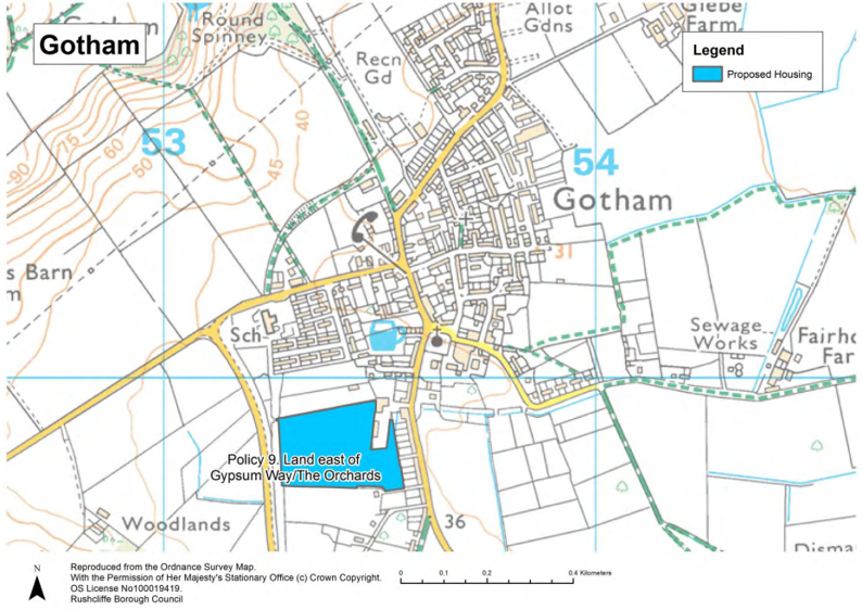
Housing Allocation at Sutton Bonington
3.114 Sutton Bonington has scope to sustain around 80 dwellings on greenfield sites adjacent to the village, based on the existing size and status of the settlement, the capacity of local services and the size of the single site deemed most suitable and sustainable for housing development.
3.115 In balancing housing requirements across Rushcliffe to 2028, sustainability, Green Belt, settlement capacity and other relevant planning considerations, land north of Park Lane (see Figure 9) is identified as a housing allocation.
Policy 10 Housing Allocation – Land north of Park Lane, Sutton Bonington
The area, as shown on the policies map, is identified as an allocation for around 80 homes.
The development will be subject to the following requirements:
- frontage development on Park Lane should not detract from the character of Park Lane as a rural tree lined approach to the village;
- a buffer on the site’s northern boundary should ensure the amenity of the residents of Charnwood Fields and Charnwood Avenue is not adversely affected;
- the amenity of new residents should not be adversely affected by noise generated by trains on the adjacent railway line;
- sustainable drainage measures must address any identified surface water run-off issues;
- development along the southern boundary of the site should respect the rural character of the area and provide a visually attractive boundary when viewed from the A6006; and
- it should be consistent with other relevant policies in the Local Plan.
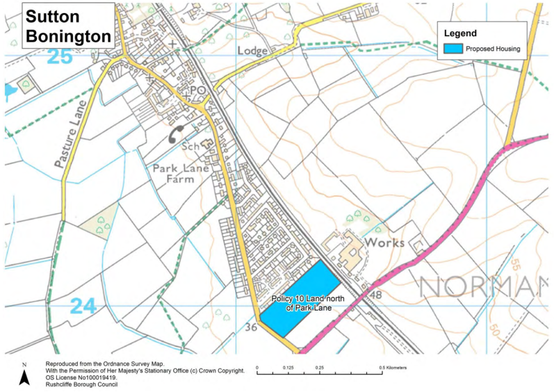
Justification
3.116 This allocation extends into the open countryside on the north side of Park Lane, a road which provides an attractive tree lined rural approach to the village from the junction with the A6006. The development of this site should ensure that the rural character of the area is preserved, as far as is possible, through sensitive frontage development on Park Lane, which preserves its tree lined rural character.
3.117 There should be sensitive development along the site’s southern boundary, respecting the rural character of the area and provide a visually attractive boundary for the village when viewed from the A6006.
3.118 In accordance with Policy 8 of the Core Strategy, 30% of the new homes should be affordable homes (comprising intermediate, affordable rent and social rent housing). This level of affordable housing was established following the consideration of local financial viability issues.
Monitoring of Policies 2 to 10
|
Targets |
Indicators |
Policy Delivery |
|---|---|---|
| Delivery of non-strategic allocations in line with housing trajectory contained within Appendix B. |
Number of completions per annum per site. |
Development Management Decisions |
Policy 11 Housing Development on Unallocated Sites within Settlements
1. Planning permission will be granted for development on unallocated sites within the built-up area of settlements provided:
- the proposal in terms of scale and location is in accordance with Local Plan Part 1: Core Strategy Policy 3 (Spatial Strategy);
- the proposal is of a high standard of design and does not adversely affect the character or pattern of the area by reason of its scale, bulk, form, layout or materials;
- the existing site does not make a significant contribution to the amenity of the surrounding area by virtue of its character or open
nature; - the proposal would not result in the loss of any existing buildings considered to be heritage assets unless the harm is, in the case of designated heritage assets, outweighed by substantial public benefits or, in the case of non-designated heritage assets, the loss of significance to the asset is justified;
- the proposal would not have an adverse visual impact or be unduly prominent from locations outside the settlement;
- the proposal would not cause a significant adverse impact on the amenity of nearby residents and occupiers; and appropriate provision for access and parking is made.
2. Planning permission will be granted for the conversion and change of use of existing buildings to residential use within the existing built up area of settlements provided:
- all homes are self-contained with suitable access arrangements;
- the proposal would not cause a significant adverse impact on the amenity of nearby residents and occupiers; and
- appropriate provision for parking and access is made.
3. Development in the rest of the plan area outside the built-up area of settlements is restricted to that which requires a countryside location or meets an essential local rural need or supports rural diversification in accordance with Policy 22 (Development within the Countryside).
Justification
3.119 Local Plan Part 1: Core Strategy Policy 3 focuses development within the main urban area of Nottingham (within Rushcliffe), the Key Settlements of Bingham, Cotgrave, East Leake, Keyworth, Radcliffe on Trent and Ruddington. Beyond the main urban area and Key Settlements policy allows housing development in ‘other villages’ to meet local need.
3.120 In addition, this Local Plan Part 2 has identified four villages where, alongside small scale infill to meet local need, a limited number of new homes should be delivered on allocated sites. Two regeneration sites have also be identified at Bunny and Flintham.
3.121 For the purposes of determining residential developments on unallocated sites within ‘other villages’ (as defined in Core Strategy Policy 3) local need and infill are defined within paragraph 3.10 of this document.
3.122 The Local Plan does not identify the settlement boundaries within which Policy 11 will apply. The location of the proposal and its relationship to neighbouring buildings and the physical edge of the settlement will determine whether the application is within the settlement or within the open countryside. For example developments that do not extend beyond the identifiable settlement boundary are considered within the settlement.
3.123 During the plan period, opportunities for new residential development on sites which are not allocated in the Core Strategy and this Local Plan Part 2 (often termed windfall developments) will come forward and it is important to ensure that this development does not adversely affect the appearance of the area or the amenity of residents. Policy 11 ensures that residential development which complies with strategic policy, but which is not within an allocation, avoids these impacts.
3.124 This includes the conversion of houses into flats and the change of use of non-residential buildings to residential use, which can provide a valuable range and variety of new homes. It also includes the provision of houses in multiple occupation. In accordance with paragraph 51 of the National Planning Policy Framework, the Council is committed to bringing empty houses and buildings back into use. In recognition of this importance and to encourage this type of development, the Council may allow lower parking standards in certain circumstances where it is considered appropriate (for example near public transport corridors or near to shopping centres).
3.125 Policy 11 seeks to protect existing buildings or other features including open spaces which make an important contribution to the appearance of the area. Small areas of open space, which may not otherwise be protected, often contribute to the character of an area by virtue of views into and out of an area, or by creating a sense of place. Similarly, existing buildings may make an important contribution to the street scene. For this reason, careful consideration will be given to the impact a development would have on the character of an area by the loss of important open space.
3.126 Housing developments within settlements should not have significant adverse effects upon the amenity of nearby residents. This includes, but is not restricted to: the loss of privacy (caused by overlooking of private gardens or views into neighbouring properties for example); overshadowing and reduction in natural light; noise (from traffic); or dust (during construction).
3.127 Policy 11 supports the conversion and change of use of existing buildings to residential use and the criteria which is applied ensures the property can be accessed and would not affect amenity of nearby residents. This policy applies equally to planning applications which propose the subdivision of existing properties.
3.128 There are certain areas which are protected from residential development. For example allocated or existing employment sites which are protected under Policy 15 (Employment Development). Development (including residential development) within the Green Belt is covered by the National Planning Policy Framework and Policy 21 (Green Belt) in this Local Plan.
Policy 12 Housing Standards
Accessibility standards
- In order to meet the needs of the Borough’s residents and to deliver dwellings which are capable of meeting peoples’ changing circumstances over their lifetime, it is required that for developments of more than 100 dwellings, at least 1% should comply with requirement M4(3)(a) of the Building Regulations regarding wheelchair adaptable dwellings.
- The M4(3)a requirement will apply unless viability evidence or site specific factors such as vulnerability to flooding, site topography or other circumstances demonstrate that it is not possible for them to be applied.
Water efficiency standards
- All new dwellings will be required to meet the higher Optional Technical Housing Standard for water consumption of no more than 110 litres per person per day.
Justification
3.129 In March 2015, the Government introduced a new approach for the setting of technical housing standards in England. This rationalised the many differing existing standards (e.g. Lifetime Homes and Code for Sustainable Homes (CfSH)) into a more streamlined system.
3.130 The Written Ministerial Statement, issued on 25 March 2015, sets out the Government’s national planning policy on the setting of these technical standards. This explains that the new system gives local planning authorities the option of setting additional technical requirements exceeding the minimum standards required by Building Regulations for new homes in respect of access and water efficiency and introducing an optional national described internal space standard.
Water efficiency standards
3.131 Approved Document G (Requirement G2) and Regulations 36 and 37 of the Building Regulations 2010 set out how the required water efficiency standards should be calculated and met.
3.132 As with the other optional standards, the optional requirement for water efficiency can only be applied where there is evidence of local need and where the viability of development is not compromised by its application.
3.133 Policy 2 of Local Plan Part 1: Core Strategy requires that new dwellings should be built to incorporate a maximum consumption standard of 105 litres per person per day. This requirement, supported by the Environment Agency and Severn Trent Water Ltd, reflects the results of the Outline Water Cycle Study (2010) and the constrained nature of supply in the East Midlands, with Rushcliffe identified as being in an area of moderate water stress (i.e. scarcity).
3.134 The Government’s Optional Technical Housing Standards supersedes the Core Strategy and requires councils to apply either the basic Building Regulation standard (of 125 litres/person/day) or a single optional higher national standard in areas of water stress of 110 litres per person per day. This optional higher standard, although slightly less stringent, is close to that proposed in the Core Strategy and is considered appropriate for Rushcliffe due to the evidence provided by the Outline Water Cycle Study. This standard should therefore be applied by planning condition and will apply to all new dwellings.
3.135 In order to ensure compliance with the National Planning Policy Framework and to ensure the approach is viable, a plan wide viability assessment has been undertaken which has included the impacts of additional statutory measures and optional policy requirements such as water consumption.
3.136 The Rushcliffe Borough Council Whole Plan and CIL Viability Assessment Report (February 2016) included costings for new housing equivalent to CfSH Code 4. Code 4 was considered by the study to incorporate the water standard of 110 litres per day. The assessments conclude that plan wide viability is not unduly affected by these requirements although careful assessment will be required on a site by site basis as part of the Development Management process. The policy approach acknowledges that some flexibility is required to address instances where the inclusion of sustainable measures is demonstrably unviable.
3.137 Further supporting evidence of the viability of adopting the optional standard for water efficiency is provided by the costs impact study 2 that was produced by the Department for Communities and Local Government in support of the new standards. This concluded that the additional cost per dwelling for complying with the 110 litre per day standard would range between £6 per dwelling and £9 per dwelling.
3.138 This is not considered to have a significant impact on viability of schemes and it is therefore appropriate to apply the more stringent water efficiency requirement.
Accessibility and wheelchair standards
3.139 In order to help deliver a wide choice of homes and create sustainable, inclusive and mixed communities, paragraph 50 of the National Planning Policy Framework states that local planning authorities should plan for the needs of different groups in the community, including older people and people with disabilities.
3.140 Policy 8 of the Core Strategy sets out that a proportion of new development in the Borough should be capable of being adapted to suit the lifetime of its occupants in terms of their accessibility needs. The justification to the policy highlights that many older people have a strong desire to remain in the housing they currently occupy as long as possible.
3.141 In 2014 there were 22,900 older people (people aged 65 and over) in Rushcliffe with the latest population forecast suggesting this will increase to 35,100 in 2034 (an increase of 53%). The number of people over the age of 80 is projected to almost double over the same period. The proportion of people in the elderly age category is increasing at a much faster rate than the overall population of the Borough (which is predicted to increase by 15% by 2034 in comparison). Rushcliffe has an older age profile when compared to England as a whole with 20% of residents over the age of 65 in 2014 (2% higher than the national average).
3.142 Although an ageing population is a trend mirrored at national level, Rushcliffe is ageing at a faster rate than the national average with this gap widening to almost 6% by 2034.
3.143 There is therefore a clear need to plan for homes that meet the needs of older people. National planning policy allows local planning authorities to set optional technical standards in for new housing in relation to accessibility and wheelchair standards through their Local Plans. Imposing these standards will help ensure that Rushcliffe’s housing stock is more easily adaptable and will help people to maintain their independence for longer.
3.144 Approved Document M of the Building Regulations 2010 sets out these standards. M4 (1): Visitability is the mandatory building standard which applies to all new homes. M4 (2): Accessible and Adaptable Dwellings and M4 (3): Wheelchair User Dwellings are the optional standards that local authorities can apply if there is a clearly evidenced need and the viability implications of introducing the standards have been adequately considered.
3.145 M4 (2) requires dwellings to meet the needs of occupants with differing needs, including some older or disabled people, and to allow adaptation of the dwelling to meet the needs of occupants over time. This category is broadly equivalent to the Lifetime Homes Standard. The most significant difference between M4(2) and Lifetime Homes is that step-free access is required to all properties. This means that all dwellings that are accessed from above the ground floor would require a lift access.
3.146 M4 (3) is split into 2 further sub-categories; (a) wheelchair adaptable (a home that can be easily adapted to meet the needs of a household including wheelchair uses) and (b) wheelchair accessible (a home readily useable by a wheelchair user at the point of completion). The standard for wheelchair accessible homes can only be applied to those dwellings where the local authority is responsible for allocating or nominating a person to live in that dwelling.
3.147 Recognising that a number of elderly person households and those from other sectors of the community are likely to have a need for adaptable or accessible homes over the lifetime of the Plan, as part of providing a mix of housing to meet housing needs, the Council will seek to secure on developments of 100 or more 1% of new housing to be built to M4 (3) (adaptable) standard.
Monitoring
|
Targets |
Indicators |
Policy Delivery |
|---|---|---|
| 1% of homes on housing developments over 100 comply with M4(3(a) of the Building Regulations |
Developments which comply with requirement M4(3)(a) of the Building Regulations |
Development Management Decisions |
| 100% of all new dwellings meeting higher optional water efficiency standards |
Developments that meet the higher optional technical housing standard for water consumption |
Development Management Decisions |
Policy 13 Self-Build and Custom Housing Provision
1. Proposals for self-build and custom homes are encouraged and will be approved provided the following criteria are met:
- the development is in an appropriate location subject to compliance with all other relevant policy requirements in the Local Plan and national policy, including Green Belt, landscape, historic and environmental designations;
- it is of a high standard of design and does not adversely affect the area by reason of its scale, bulk, form, layout or materials;
- it would not cause a significant adverse impact on the amenity of nearby residents or occupiers; and
- there is no significant adverse impact on highway safety and adequate provision for access and parking is made.
Justification
3.148 Self-build housing is when an individual directly organises the design and construction of their new home. Custom build housing is defined as when an individual commissions a builder to help to deliver their own home.
3.149 The National Planning Policy Framework requires local planning authorities to identify local demand for people who wish to build their own homes and make provision in their local plans. The Government wants to increase the capacity and diversity of the house building industry and build more quality new homes faster. The self-build and custom sector can play a key role in achieving this
through the Government’s new ‘Right to Build’ policy. The Self-Build and Custom Housebuilding Act 2015 places a duty on local planning authorities to keep a register of individuals and community groups who have expressed an interest in bringing forward self-build and custom build projects. The Act also requires that local planning authorities have regard to the level of demand shown on the local register. The local register for Rushcliffe Borough is available on the Council’s website.
3.150 Custom and self-build offers greater opportunity for the use of sustainable construction techniques and more innovative eco-friendly design. Proposals that maximise such techniques and incorporate sustainable design features and maximise design opportunities arising from the location of the site, will be encouraged by the Council where they accord with other Local Plan policies.
|
Targets |
Indicators |
Policy Delivery |
|---|---|---|
| The granting of planning permission for a sufficient quantity of self and custom build plots to meet local need | Annual monitoring of the number of plots with planning permission available capable of accommodating self and custom build homes | Development Management decisions. |
Policy 14 Specialist Residential Accommodation
Planning permission will be granted for specialist accommodation that falls within Use Class C2 (Residential Institutions) of the Use Classes Order, provided:
- the proposal is located in an existing residential area, close to good public transport routes, shops, community facilities and open space appropriate to the needs of the occupiers;
- the proposal would not result in an over concentration of similar uses in any one area, leading to a significant adverse impact on the character of the area;
- the proposal would not have an unacceptable impact on existing health care facilities;
- a satisfactory residential environment can be achieved for the benefit of the intended occupants without detriment to the amenity of nearby dwellings; and
- there is no significant adverse impact on highway safety and adequate provision for access and parking is made.
Justification
3.151 The Use Classes Order 1987 (as amended) defines Use Class C2 (Residential Institutions) as residential care homes, hospitals, nursing homes, boarding schools, residential colleges and training centres. Policy 14 applies to developments within this use class, or if the use class is amended, the equivalent use class(es).
3.152 The term ‘specialist accommodation’ is used to refer to the range of housing options built to assist people, such as older people, adults with learning disabilities and/or autism, people with physical disabilities and vulnerable adults, including those with mental health issues, with their accommodation and support needs. A variety of different specialist housing for people exists and new models are being created, such as Extra Care Housing, Retirement Housing and Sheltered Housing.
3.153 In 2014, Rushcliffe Borough was home to 22,900 people aged over 65. This figure is expected to increase to around 35,100 by 2034. The population aged over 85 is expected to more than double over the same period. As people get older, their housing needs change. Accessible and adaptable housing is needed for those looking to downsize from family housing and the full range of retirement and specialised housing is needed for those with support or care requirements.
3.154 Specialist accommodation should be located in existing residential areas which are well served by local facilities, as the distances which people in residential care can travel is often limited. Such locations will also help to ensure that staff and visitors to the premises do not have to travel long distances. Where there are capacity issues raised in relation to existing healthcare facilities which serve a proposal, planning obligations may be sought in order to mitigate against such impacts.
3.155 The types of properties which are normally considered to be the most appropriate for conversion to specialist accommodation are often located in areas where such uses are already common (due to the size of property and the plot in which it stands). An over concentration of such uses can materially change the character of an area and therefore new specialist accommodation should be well distributed throughout the existing residential area.
|
Targets |
Indicators |
Policy Delivery |
|---|---|---|
| No target | Number of Planning permissions and completions for specialist accommodation |
Development Management decisions |
4. Employment Development
Policy 15 Employment Development
- The following sites are allocated for employment development:
a) Chapel Lane Bingham (east);
b) Chapel Lane Bingham (west);
c) Hollygate Lane Cotgrave;
d) Platt Lane Keyworth;
e) Nottingham Road Radcliffe on Trent (as part of mixed use development); and
f) Former Bunny Brickworks (as part of mixed use development).
- Planning permission will be granted for the expansion, conversion or redevelopment of land and premises for employment uses on allocated employment sites and other employment sites provided:
a) the employment use is within Use Classes B1, B2 or B8, or is an employment generating use which is compatible with its surrounding uses;
b) the employment use provides facilities and services which support the functioning of the employment site provided they are of an appropriate scale; and
c) the proposal would not cause a significant adverse impact on the amenity of nearby residents and occupiers.
- Planning permission will not be granted for the redevelopment or reuse of existing employment sites or premises for other non-employment purposes unless:
a) it is demonstrated that there is no demand for the site or premises for its specified employment use;
b) the site is not viable for re-occupation (including through renewal or refurbishment); and
c) the proposed use would not cause a significant adverse impact on the amenity of nearby residents and occupiers.
- Planning permission will be granted provided there is no significant adverse impact on highway safety and adequate provision for access and parking is made.
Justification
4.1. Since the adoption of their Core Strategies, the Greater Nottingham councils commissioned a new Employment Land Forecasting Study (August 2015).
This new evidence indicates that the requirement for employment land within Rushcliffe Borough. The office floorspace requirements range between about 96,000 to 105,000 square metres, which is higher than previously projected. Industrial land requirements are generally within the range of 40 to 50 hectares, also higher than previously projected. This reflects that future growth in Rushcliffe is projected to be higher than past trends both in terms of job and labour supply growth, which accords with the objectives of Policy 5 of
the Core Strategy. The strategic allocations in the Local Plan Part 1: Core Strategy are not additional to the employment land targets for Rushcliffe Borough set out above.
4.2. The additional employment sites within Local Plan Part 2, existing employment sites and the strategic mixed use allocations contained within the Core Strategy provide a good range and choice of sites and premises in terms of size, type and location. Policy 5 of the Core Strategy seeks to ensure that allocations most attractive to the market remain available for employment uses. Policy 5 also seeks to retain employment sites that are an important source of jobs, and sites that support less skilled jobs in and near deprived
areas.
4.3. Policy 5 outlines that economic development of a lesser scale will be delivered elsewhere in sustainable locations and in accordance with the settlement hierarchy contained within the Core Strategy. Local Plan Part 2 reallocates sites for employment development at Chapel Lane, Bingham and at Hollygate Lane, Cotgrave, both of which are key settlements within the Borough. In addition an additional employment allocation is made at Nottingham Road Radcliffe on Trent as part of a mixed use allocation.
4.4. The two sites that are reallocated at Chapel Lane Bingham (see Figure 10) are small sites surrounded by existing employment development. Whilst these are long-standing employment allocations the nature of surrounding development being predominantly employment development as part of an industrial estate means that other uses are considered to be incompatible in these locations. The sites will also provide potential employment opportunities to support significant housing growth in the east of the Borough. The reallocation of land at Hollygate Lane Cotgrave (see Figure 1) will provide the opportunity for additional employment development to complement the additional housing allocations identified in Local Plan Part 2. The allocation at Platt Lane, Keyworth (Figure 3) will provide additional employment land in order to support the proposed housing growth. In addition the allocation is contained within the Keyworth Neighbourhood Plan as a recommended employment allocation. Access to the site may have to be achieved through
land that is in the Green Belt. As an engineering operation, access arrangements are not considered to be inappropriate development within the Green Belt provided that they preserve the openness of the Green Belt and do not conflict with the purposes of including land within the Green Belt.
4.5. The employment allocation at Radcliffe on Trent (see Figure 4) is part of a mixed use allocation. Other than the village centre and St James Business Park, there are limited opportunities for new employment development around the village. The employment allocation provides the opportunity for complimentary employment development adjacent to Radcliffe on Trent to support the housing allocations around the village. In addition the employment area will provide a buffer between the housing allocation and the RSPCA in terms of noise disturbance. The pylons that run through the wider mixed use allocation provides a boundary between the housing and employment as there is a requirement for a buffer along the route of the pylons.
4.6. Sequentially, new B1(a) office development should preferably be directed to town and local centres. It is, however, considered that there is limited opportunity for office development in such locations within Rushcliffe given a general lack of available or suitable sites. Proposals for B1(a) office development on the sites allocated by Policy 15 will not need to be subject to a sequential test. This is because the National Planning Policy Framework sets out that the test is not required for applications in accordance with an up-to-date Local Plan.
4.7. Existing employment sites are located throughout the Borough and the Council will consider releasing such sites for non- employment uses only where they are no longer in demand. This will require evidence that they have been marketed for their intended employment purpose without success for a sufficient period of at least 12 months (although this may be varied on a case by case basis); and they are not economically viable, which will require a financial appraisal to provide evidence that the premises are not economically
viable for reoccupation or refurbishment for employment uses.
4.8. Recent trends in employment have seen a major shift towards more service based jobs and a decline in manufacturing employment although manufacturing employment is stabilising and remains an important sector in the local economy.
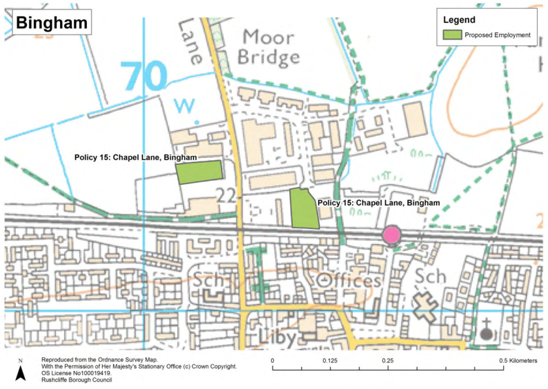
4.9. Whilst most job growth within the Borough is forecast to be in traditional type employment, some job growth will be in occupations such as health, education and accommodation/food (including hotels and catering). These are land uses which do not fall within the traditional definition of employment uses and for which specific allocations of employment land are not made. Some of these uses can be located on employment sites where they support other employment uses or otherwise would not conflict with the main purpose of the site. The following uses are likely to be acceptable on employment sites:
- industrial or commercial training facilities;
- community facilities;
- specialised leisure uses which cannot be accommodated in centres because of their scale and/or operational impacts;
- essential public utilities development; and
- ancillary facilities and services which support the functioning of the employment site including child care facilities, small-scale retail uses, sandwich shops and cafés.
4.10. This list is not exhaustive and individual cases should be judged on merit with the key consideration being whether the proposed use would be compatible with the main purpose of the employment site and also with areas, especially residential areas, that may surround it. Retail and main town centre uses are subject to the sequential approach which directs these uses to locations within
town centres or edge of centre locations.
|
Targets |
Indicators |
Policy Delivery |
|---|---|---|
| No target | Annual monitoring of the amount of employment land permitted and completed over 100 square metres floorspace or 0.1 hectares total area |
Development Management decisions |
| No target | Annual monitoring of the amount of employment land permitted and completed over 100 square metres floorspace or 0.1 hectares total area |
Development Management decisions |
5. Climate Change, Flood Risk and Water Management
Policy 16 Renewable Energy
- Proposals for renewable energy schemes will be granted planning permission where they are acceptable in terms of:
- compliance with Green Belt policy:
- landscape and visual effects;
- ecology and biodiversity;
- best and most versatile agricultural land;
- the historic environment;
- open space and other recreational uses;
- amenity of nearby properties;
- grid connection;
- form and siting;
- mitigation;
- the decommissioning and reinstatement of land at the end of the operational life of the development;
- cumulative impact with existing and proposed development;
- emissions to ground, water courses and/or air;
- odour;
- vehicular access and traffic; and
- proximity of generating plants to the renewable energy source.
- In addition to the above criteria, wind energy developments will be permitted provided:
- the development site is in an area identified as being suitable for wind turbine development in a Neighbourhood Plan; or
- the development site is in an area identified as being of low or low-medium sensitivity to wind turbine development in Appendix C; and
- following consultation, it can be demonstrated that the planning impacts identified by affected local communities have been fully
addressed and therefore the proposal has their backing.
Justification
5.1 Renewable and low carbon energy can be generated by a wide range of different technologies. These include:
- Wind energy;
- Solar panels;
- energy from waste;
- biofuel;
- ground source heat pumps;
- geothermal; and
- hydropower
5.2 Paragraph 93 of the National Planning Policy Framework highlights the importance of supporting the delivery of renewable and low carbon energy and emphasises that tackling and adapting to climate change is central to sustainable development.
5.3 Core Strategy Policy 2 (Climate Change) part 5 states that new decentralised, renewable and low-carbon energy schemes will be promoted and encouraged within Rushcliffe, where these are compatible with environmental, heritage, landscape and other planning considerations. Policy 16 outlines these considerations in greater detail and ensures they are considered when determining any planning application for renewable energy schemes.
5.4 As a significant proportion of the Borough is covered by the Nottingham-Derby Green Belt, it is likely that proposals for renewable schemes will be promoted within this designation during the plan period. Therefore Green Belt policy as set out in national policy will apply.
5.5 Paragraph 91 of the National Planning Policy Framework states when located in the Green Belt, elements of many renewable energy projects will comprise inappropriate development. In such cases developers will need to demonstrate very special circumstances if projects are to proceed. These very special circumstances may include the wider environmental benefits associated with increased production of energy from renewable sources.
5.6 In accordance with the National Planning Policy Framework, these wider environmental benefits must be balanced against the harm that may be caused to the Green Belt’s openness, its purposes and any other harm. Other harm would include non-compliance with the criteria set out in Policy 16.
5.7 Proposals for renewable energy schemes within the countryside, beyond the Green Belt boundary, or within settlements removed from the Green Belt should, where applicable, comply with the remaining criteria (parts (b) to (o)).
5.8 The criteria have been identified using the guidance provided in the National Planning Practice Guidance and the policy context in Rushcliffe. The policy acts as a checklist and a signpost to specific policies which should be used to determine whether proposals are acceptable or not. If proposals are not acceptable in terms of one or more of the identified factors, a decision will be taken balancing the benefits and impacts of the proposal. The more significant the impact, the more likely it is that planning permission would be refused.
5.9 Depending on the technology proposed and its location, applicants will be expected to provide the following information:
- a landscape and visual impact assessment;
- a heritage impact assessment;
- noise assessments;
- ecological assessment; and
- evidence of consultation with utility providers.
Wind Energy
5.10 The Council has prepared evidence on the impact of wind energy on the landscape. The Melton and Rushcliffe Landscape Sensitivity Study 2014 indicates the areas which have the most capacity and are the least sensitive for renewable wind energy development. This evidence has been used to inform policy on renewable energy such that it complies with the ministerial statement issued in June 2015 by the Secretary of State for Communities and Local Government, which is referenced in the National Planning Practice Guidance. This set out new considerations to be applied to proposed wind energy development such that when determining planning applications for
wind energy development involving one or more wind turbines, local planning authorities should only grant planning permission if:
- the development site is in an area identified as suitable for wind energy development in a local or neighbourhood plan; and
- following consultation, it can be demonstrated that the planning impacts identified by affected local communities have been fully addressed and therefore the proposal has their backing.
5.11 In applying these new considerations, suitable areas for wind energy development have been allocated clearly in a local or neighbourhood plan. Whether a proposal has the backing of the affected local community is a planning judgement for the local planning authority.
5.12 The Melton and Rushcliffe Landscape Sensitivity Study divides the Borough’s landscape into 14 Landscape Character Assessment Units and makes a judgment on the landscape sensitivity to different heights of turbine.
5.13 It is considered that Landscape Character Assessment Units (LCUs) judged as being of Low or Low-Medium sensitivity are suitable for wind energy development for the turbine heights defined in the Melton and Rushcliffe Landscape Sensitivity Study. These Landscape Character Assessment Units and their sensitivity to wind energy development are identified in Appendix C.
5.14 It should be noted that the Study is not a definitive statement on the suitability of a certain location for wind energy development, and compliance with all pertinent criteria within Core Strategy Policy 2, the criteria set out in Part 1 of this policy, and other Local Plan policies is required.
5.15 Critically the development of wind turbines should comply with the Borough’s Wind Energy Supplementary Planning Document (SPD). This document assists the interpretation and application of those policies within the Rushcliffe Local Plan Part 1: Core Strategy concerned with renewable energy, Green Infrastructure, biodiversity, design and enhancing local identity and historic environment is so far as they relate to wind energy development. This SPD was itself informed by the Landscape Sensitivity Study 2014.
5.16 The layout and design of wind energy development proposals should be informed by the SPD and the generic and detailed guidance for each Landscape Character Unit in the Melton and Rushcliffe Landscape Sensitivity Study 2014.
Monitoring
|
Targets |
Indicators |
Policy Delivery |
|---|---|---|
| To reduce per capita CO2 emissions |
Per capita CO2 levels |
|
| Increase renewable power generation | Annual monitoring of new renewable energy generation completed over 0.1Mw (100Kw |
|
Policy 17 Managing Flood Risk
1. Planning permission will be granted for development in areas where a risk of flooding or problems of surface water disposal exists provided that:
- the sequential test and exception test are applied and satisfied in accordance with the National Planning Policy Framework and National Planning Policy Guidance; or
- where the exception test is not required, for example change of use applications, it has been demonstrated that the development and future occupants will be safe from flood risk over the lifetime of the development; or
- the development is for minor development where it has been demonstrated that the Environment Agency’s flood risk standing advice has been followed, including:
- an industrial or commercial extension of less than 250 square metres;
- alterations to buildings that do not increase the size of the building;
- householder development including sheds, garages within the curtilage of the dwelling; and
- development does not increase the risk of flooding on the site or elsewhere, including through increased run-off due to areas of
hardstanding, or reduction in ground water storage as a result of basements.
2. Development proposals in areas of flood risk will only be considered when accompanied by a site specific flood risk assessment. Proposals will be expected to include mitigation measures which protect the site and manage any residual flood risk, such as flood resistance/resilience measures and the provision of safe access and escape routes.
Justification
5.17 Local Plan Part 1: Core Strategy Policy 1 sets out the approach to development within areas at risk of flooding (Flood Zones 2, 3a and 3b), including the sequential test which directs development to low risk flood areas (Flood Zone 1) and, where this is not possible or less sustainable, the exception test which requires the development and future occupants to be safe from flood risk over the lifetime of the development. It also outlines the requirement to incorporate sustainable drainage systems. Further policies in this document outline how development within areas at risk of flooding should be managed and how improved water management can deliver additional benefits, most notably to the wider environment.
5.18 Significant areas of Rushcliffe, notably within West Bridgford, are within flood zones 2, 3a and 3b and these areas will continue to see a significant number of windfall developments within the plan period. As set out in Core Strategy 3, the sustainable development of Rushcliffe will be achieved through a policy of urban concentration and regeneration, therefore development within West Bridgford, which is closer to local services and facilities, but within flood zone 2 is considered sequentially preferable to development on the edge of the main urban area or outlying settlements that is within flood zone 1.
5.19 Flood Zone 3b is defined as functional flood plain and national planning policy guidance makes clear that ‘more vulnerable’ residential development is not appropriate in these areas, and should not therefore be permitted. Development in these areas will only be considered as a last resort, where it is required for regeneration purposes, and it can be demonstrated that the proposals will reduce the existing levels of flood risk to both the application site and third parties. As required by the adopted Local Plan Part 1: Core
Strategy, Policy 17 contains detailed criteria for determining planning applications which are located within areas at risk of flooding.
5.20 National Planning Practice Guidance makes it clear that the sequential test does not need to be applied to proposals on sites which have been allocated in the adopted Local Plan or to minor developments and changes of use except for a change to a caravan, camping, chalet or mobile home site which are more vulnerable to flood risk. However, the National Planning Policy Framework confirms that proposals will still be required to demonstrate that the development would be safe over its lifetime without increasing flood risk
elsewhere.
5.21 A site specific flood risk assessment (FRA) is required for all proposals including minor development and change of use in either flood zones 2 or 3 and in an area which has critical drainage problems. The FRA should examine the likelihood of a proposal being affected by current or future flooding from any source and take into account climate change. The FRA will also need to demonstrate that the proposal would not increase the risk of flooding elsewhere. In particular, surface water run-off from the development will need to be managed so as not to cause an adverse impact elsewhere through increased flood risk. Further guidance on managing surface water is set out in Policy 18.
5.22 The FRA should include the following:
- evidence of the application of the sequential test and if necessary the exception test;
- an assessment of risks to the development site during a flood. The FRA should consider flooding from all sources including rivers and the sea and include an allowance for climate change;
- the estimated flood level for the site, i.e. the 1 in 100 year river flood level. Applicants may be able to obtain this from the Environment Agency or the Local Planning Authority;
- defences details of existing flood resistance and resilience measures on the site including existing flood defences or structures;
- state how the proposed design will reduce flood risk, e.g. by placing land uses most sensitive to flood damage in the areas of the site at least flood risk, or raising finished floor levels;
- evidence that the proposal will not increase flood risks elsewhere, for example through increased run-off due to areas of hardstanding, or reduction in ground water storage as a result of basements;
- access and egress arrangements including details of how people will leave buildings during flood;
- details of operation and maintenance of any flood mitigation measures; and
- confirmation of the residual risks to the site after any necessary flood defences have been built or considered, along with confirmation of how it is planned to manage these risks.
5.23 In drawing up FRAs, the Greater Nottingham Strategic Flood Risk Assessment (updated 2017) is an important source of information on the probability of a flood occurring and on residual risks. Information is provided on the nature, severity, depth, water velocity and rate of onset of a flood and the likely flood hazard due to a breach or overtopping of defences or overloading of surface water drainage systems.
Flood Risk Management and Biodiversity
5.24 The Council will encourage measures to protect and enhance the Borough’s water environment which supports a range of habitats and ecosystems. Development will be permitted where it incorporates surface water as a design feature and identifies measures to improve and enhance water bodies and/or provides additional flood alleviation.
5.25 The Council will encourage and promote flood risk management measures that conserve and enhance biodiversity (seeking to achieve good ecological status) through Policy 18 which manage watercourses, reduce flood risk and protect and improve floodplains and biodiversity. The Council will seek to promote the creation of new areas for habitats and species and to reconnect sites to their floodplain. New development should consider working with or restoring natural flooding processes with the aim of reducing flood risk and delivering biodiversity benefits.
|
Targets |
Indicators |
Policy Delivery |
|---|---|---|
| No planning applications approved | Number of planning applications in flood risk areas approved against Environment Agency advice. |
Development Management Decisions |
Policy 18 Surface Water Management
- To increase the levels of water attenuation, storage and water quality, and where appropriate, development must, at an early stage in the design process, identify opportunities to incorporate a range of deliverable Sustainable Drainage Systems, appropriate to the size and type of development. The choice of drainage systems should comply with the drainage hierarchy.
- Planning permission will granted for development which:
- is appropriately located, taking account of the level of flood risk and which promotes the incorporation of appropriate mitigation measures into new development, such as sustainable drainage systems;
- reduces the risk to homes and places of work from flooding;
- delivers a range of community benefits including enhancing amenity (ensuring a safe environment) and providing greater resistance to the impact of climate change;
- contributes positively to the appearance of the area;
- accommodates and enhances biodiversity by making connections to existing Green Infrastructure assets; and
- retains or enhances existing open drainage ditches.
Justification
5.26 Nottinghamshire County Council as the Lead Local Flood Authority developed and adopted its Flood Risk Management Strategy (FRMS) in 20163 . The FRMS identifies the flood risks within Nottinghamshire (excluding Nottingham City) and provides a framework for coordinating the management of these flood risks. This strategy prioritises public funding for hard flood defences and also sets out other ways of managing flooding problems and flood risk. Examples of the latter may include advice on planning for sustainable development, guidance on development control and the environmental management of water courses. The Local Lead Flood Authority is also a
statutory consultee for planning applications for major development (over 10 dwellings) in relation to the management of surface water.
5.27 Where appropriate development proposals must take account of relevant Surface Water Management Plans and local flood risk management strategies. The Council may seek financial contributions from development on sites where measures to address flood risk or to improve the environmental quality of watercourses have been identified by these plans and strategies.
5.28 Where appropriate and technically feasible, proposals for both major and minor development proposals must incorporate sustainable drainage systems within both public and private areas of the development in order to provide source control features to the overall sustainable drainage design. These features may include attenuation ponds, green roofs, permeable driveways
and parking, soakaways, water harvesting and storage features including water butts. In accordance with national guidance, the selection of sustainable drainage systems should comply with the drainage hierarchy. The hierarchy identifies ground infiltration as the preferred method of managing surface water issues followed by: collection within a surface water body; directing to a surface water sewer, highway drain, or another drainage system; or, if none of these are possible, to a combined sewer.
5.29 In addition to the delivery of sustainable drainage systems, the long term management costs of these systems will also be paid for by the applicant. This usually occurs through the employment of a management company.
5.30 To ensure that sustainable drainage systems discharge water from the development at the same or lesser rate than pre-construction, the following criteria should be met:
- The proposed drainage system must be designed to ensure that there is no flooding on a 1 in 30 year storm event;
- The design must also take account of the 1 in 100 year storm event plus 20% to 40% allowance for climate change, on stored volumes, to ensure that there is no flooding of buildings. Any excess flows must be contained within the site boundary, and within designated storage areas;
- Run-off from greenfield sites should be limited to the equivalent calculated green field run-off rates or 5 litres per second per hectare, whichever is lower; and
- Runoff from brownfield sites should be restricted to equivalent greenfield land requirements where possible/achievable, but should look to reduce the rate of runoff by a minimum of 30% from the existing discharge rates.
Monitoring
|
Targets |
Indicators |
Policy Delivery |
|---|---|---|
| No target | Number of developments incorporating sustainable drainage systems |
Development Management Decisions |
| No planning applications approved | Number of planning applications approved against the advice of the Lead Local Flood Authority |
Development Management Decisions |
Policy 19 Development affecting Watercourses
In order to protect, conserve and enhance watercourse corridors, the Council will support development proposals that:
- reconnects land to the functional floodplain and restores natural flooding processes;
- does not have an adverse impact on the functions and setting of any watercourse and its associated corridor;
- seeks to conserve and enhance the biodiversity, landscape and recreational value of the watercourse and its corridor through good
design; - pursues opportunities for de-culverting of watercourses. Planning permission will only be granted for proposals which do not involve the culverting of watercourses and which do not prejudice future opportunities for de-culverting (including on sites specifically identified in the Local Plan);
- provides a minimum10 metre buffer where physically feasible between the top of the watercourse and the development site which is free of built development, and includes a long term landscape and ecological management plan for this buffer; and
- includes, where appropriate, measures to allow for the natural movement of fish within the watercourse (where barriers to fish movement are present).
Justification
5.31 Watercourses and their associated corridors are a vital element of the Green and Blue Infrastructure of the Borough. They have several valuable functions – as a landscape feature, for biodiversity especially as a corridor to allow movement of species, for recreation, as a water resource and to allow access for river maintenance. Of particular importance in the Borough is the River Trent, River Soar, River Smite and Fairham Brook, however smaller watercourses and waterbodies also have a key role.
5.32 Development sites which include watercourses are expected to maintain a 10 metre buffer either side of the watercourse within which developments should be restricted. This width of buffer provides the minimum width of habitat needed to provide for the functioning of wildlife habitats, while being able to facilitate management of the watercourse and informal access for enjoyment
of the river. This width also ensures that the river is buffered from land-based activities, e.g. reducing the levels of diffuse pollution reaching the watercourse.
5.33 Where an undeveloped buffer of 10 metres (or more) already exists along a watercourse, a minimum 10 metre buffer should be maintained as a natural or semi-natural habitat free from built development, parking areas, private gardens and formal landscaping. A buffer should be provided on both sides of a watercourse that runs through a development. Developments proposed on previously developed land within 10 metres of a water course are exempt from the requirements of part (e) of the policy.
5.34 Detailed design of the buffer zone will be determined on a site-by-site basis in consultation with the Environment Agency.
5.35 Proposals that seek to combine new development with measures to restore heavily modified watercourses and their flood plains to a more natural state will be supported. Such measures include removing culverts, restoring meanders and reconnecting river channels with areas of flood plain obstructed by artificial features.
5.36 These types of measures can result in reductions in flood risk as well as significant improvements in amenity, biodiversity and water quality.
5.37 Any development proposals that come forward will be required to demonstrate that they do not prejudice de-culverting of any watercourse in the longer term.
5.38 Development proposals affecting, or in the vicinity of, watercourses classed as a ‘main river’ may also require an Environmental Permit from the Environment Agency. The permitting process is entirely independent of the planning system and any application will be determined under separate legislation. Applicants are therefore advised to contact the Environment Agency for pre-application permitting discussions as soon as possible in these particular instances.
Policy 20 Managing Water Quality
Where risks to water quality are identified, planning applications should ensure development proposals do not have an adverse effect on water quality through the pollution of surface water bodies or groundwater.
Justification
5.39 The European Union Water Framework Directive requires each member state to manage the water environment to consistent standards with a key objective of achieving a good water quality status by 2027. Requirements of the Directive include:
- prevent deterioration in the status of aquatic ecosystems, protect them and improve the ecological condition of waters;
- aim to achieve at least good status for all water bodies by 2015. Where this is not possible and subject to the criteria set out in the Directive, aim to achieve good status by 2021 or 2027 (the relevant date depending on the previous status of the water body and the level of improvement required);
- meet the requirements of Water Framework Directive Protected Areas;
- promote sustainable use of water as a natural resource;
- conserve habitats and species that depend directly on water;
- progressively reduce or phase out the release of individual pollutants or
- groups of pollutants that present a significant threat to the aquatic environment;
- progressively reduce the pollution of groundwater and prevent or limit the entry of pollutants; and
- contribute to mitigating the effects of floods and droughts.
5.40 The key means of implementing the Framework is the preparation of River Basin Management Plans which are a holistic approach to managing water throughout its water cycle. These plans include environmental objectives and measures and should integrate with other plans and policies including spatial plans. Rushcliffe Borough is located within both Soar Basin Management Plan and the Erewash and Lower Trent Basin Management Plan areas and these contain objectives and measures and also set out current and objective status
limits for water bodies in its catchment area.
5.41 In considering planning proposals which may adversely impact on the water quality of a water body, consideration will be given to whether the proposal would result in the likelihood of a water body failing to meet the status class limits set out in the relevant River Basin Management Plan. In line with the objectives of the Water Framework Directive, development should not result in any water body failing to meet the class limits set out in the Humber River Basin Management Plan for the Soar or Erewash and Lower Trent or any
standards which supersede these. If this were the case then planning permission would be not be granted. In this context, the Council may seek advice from relevant specialist bodies including the Environment Agency.
5.42 Some development proposals, for example hydropower schemes and modifications to watercourses or structures, may require the submission of a Water Framework Directive (WFD) Assessment. This assessment should determine the effects of proposed works on ecological status and, identify any potential impacts that could cause deterioration in the status of a water body or could hinder the water body from meeting its WFD objectives. The Environment Agency typically require a WFD assessment to accompany applications for Environmental Permits for flood risk activities, and may request to see one as part of planning applications where a permitting
application has not yet been received.
6. Green Belt and the Countryside
Policy 21 Green Belt
- The boundaries of the Green Belt in Rushcliffe are as defined on the Policies Map.
- Applications for development in the Green Belt will be determined in accordance with the National Planning Policy Framework.
Justification
6.1 Local Plan Part 1: Core Strategy Policy 4 part 2 retained Cotgrave, Cropwell Bishop, East Bridgford, Keyworth, Radcliffe on Trent, Stanton on the Wolds (part of), Ruddington and Tollerton as inset settlements (surrounded by Green Belt).
6.2 In addition part 3 of Core Strategy Policy 4 identified Bradmore, Bunny, Cropwell Butler, Gotham, Newton, Plumtree, Shelford and Upper Saxondale as settlements that will be inset (removed from the Green Belt) through Local Plan Part 2. The defined policies map, informed by a Green Belt Review (Part 2b), therefore identifies the altered Green Belt boundaries for the additional inset settlements and those that have been retained as inset settlements.
6.3 Core Strategy Policy 4 part 3 also permits the alteration of the Green Belt in order to accommodate development requirements until 2028 (as set out in Core Strategy Policy 3). In addition to the allocation of land on the edge of the Key Settlements, exceptional circumstances have been established to remove land on the edge of Cropwell Bishop, East Bridgford and Gotham and allocate
it for housing development in order to deliver a five years supply of the Core Strategy’s development requirements.
6.4 The defined Green Belt boundary has also been altered to address minor inconsistencies between the boundaries which were previously established within the Local Plan (1996) and the physical situation today. Minor amendments have been made were necessary to rectify these anomalies and ensure the Green Belt boundary remains a defensible demarcation between the open countryside and inset settlements.
Health and Well-Being Benefits
6.5 The Government and the Council place considerable importance on promoting healthy communities. Paragraph 145 of the National Planning Policy Framework (2019) states that facilities for outdoor sports and recreation are not inappropriate development as long as the facilities preserve the openness of the Green Belt and do not conflict with the purposes of including land within it. Where a proposal would have such an effect on the Green Belt or its purposes and is consequently deemed inappropriate development, the benefits of the proposal to health and well-being will be given significant weight when assessing whether very special circumstances exist.
6.6 The Council believes that, in Rushcliffe, the protection of the Green Belt can be achieved alongside the encouragement of healthy lifestyles and the provision of appropriate outdoor sport and recreation facilities. When determining whether a proposal is appropriate development in the Green Belt, and if not, whether very special circumstances exist, in addition to the benefits to health and wellbeing, attention will be paid to detailed matters including the scale of the proposal, the openness of the site and its surroundings, its
contribution to the Green Belt purposes, parking and lighting arrangements.
Historic Towns and Villages
6.7 The National Planning Policy Framework outlines the five purposes of Green Belt and all should be considered when assessing a development’s impact on the Nottingham-Derby Green Belt. The fourth purpose serves to preserve the setting and special character of historic towns and within Rushcliffe this is given equal weight as the four remaining Green Belt purposes. This ensures the setting and historic character of the urban edge of Nottingham and all Rushcliffe’s inset settlements (both towns and villages) are preserved.
6.8 This was considered through the Green Belt Review, where the setting of historic features (scheduled ancient monuments, listed buildings, conservation areas, and buildings of local interest) were considered when determining the performance of Green Belt land against its purposes.
Policy 22 Development within the Countryside
- Land beyond the Green Belt and the physical edge of settlements is identified as countryside and will be conserved and enhanced for the sake of its intrinsic character and beauty, the diversity of its landscapes, heritage and wildlife, the wealth of its natural resources, and to ensure it may be enjoyed by all.
- Within the countryside development for the following uses will be permitted subject to the requirements set out in (3) below:
- agriculture, equestrian, forestry and other uses requiring a rural location, including, where justified, associated workers dwellings;
- the re-use and adaptation of buildings for appropriate uses, including housing;
- exception sites for affordable housing;
- extension and replacement of dwellings;
- expansion of all types of business and enterprise in rural areas, both through conversion of existing buildings and well-designed new buildings;
- small-scale employment generating development, retail and farm diversification;
- community services and facilities meeting a proven local need; recreation, wildlife conservation, leisure, tourism, and sports
development which requires and is appropriate in a countryside location; and - renewable energy in accordance with Policy 16.
- Developments in accordance with (2) above will be permitted where:
- the appearance and character of the landscape, including its historic character and features such as habitats, views, settlement pattern, rivers, watercourses, field patterns, industrial heritage and local distinctiveness is conserved and enhanced;
- except for replacement dwellings, conversions and changes of use, it does not constitute isolated residential development which is separated from the physical edge of the settlement;
- it does not create or extend ribbon development;
- built development is well integrated with existing buildings, where appropriate; and
- the development will not seriously undermine the vitality and viability of existing district and local centres, and centres of neighbourhood importance.
Justification
6.9 Rushcliffe is a predominantly rural Borough, which, beyond West Bridgford comprises open countryside that separates attractive villages and small towns. A significant area of the Borough is designated as Green Belt which extends beyond the settlements of East Bridgford to the north, Cotgrave to the east and Gotham to the south. The Green Belt boundary is established within Core Strategy Policy 4 and Policy 21 within this Local Plan and it is identified on the policies map.
6.10 Policy 22 will apply where development is located beyond the Green Belt, development allocations and outside the physical boundaries of the following settlements:
- Aslockton
- Barnstone
- Bingham
- Car Colston
- Colston Bassett
- Costock
- East Leake
- Elton
- Flawborough
- Flintham
- Granby
- Hawksworth
- Hickling
- Kinoulton
- Kneeton
- Langar
- Normanton on Soar
- Orston
- Rempstone
- Scarrington
- Screveton
- Shelton
- Sibthorpe
- Stanford on Soar
- Stanton on the Wolds
- Sutton Bonington
- Sutton
- Thoroton
- Tithby
- Upper Broughton
- West Leake
- Whatton in the Vale
- Widmerpool
- Willoughby on the Wolds
- Wysall
6.11 The Local Plan does not identify the settlement boundaries for the above settlements, beyond which Policy 22 will apply. The location of the proposal and its relationship to the physical edge of the settlements will determine whether the application is within the settlement or within the open countryside. For example developments that extend beyond the identifiable settlement boundary are considered within the countryside. Existing outlying buildings, or larger clusters of buildings, separated from the identifiable boundary of the settlement by more than a small scale infill plot are within the open countryside and development located between these buildings and the settlement would be subject to Policy 22. Policy 11 will be applied where a development is located within a settlement.
6.12 In the case of settlements beyond the Green Belt, which are surrounded by open countryside, settlement boundaries could be established through a Neighbourhood Plan. This would be written by the Parish Council and adopted by the Council as part of the statutory development plan. The settlement boundary would then determine were policies 11 and 22 are applied.
6.13 The uses listed above are those which it is considered would be potentially appropriate in the countryside but it will be necessary to ensure that proposed development does not unduly impact upon the character and appearance of the countryside.
6.14 The landscape of the countryside varies in character and appearance across the Borough. It is important that account is taken of these differences in considering development proposals in the countryside. As required by Core Strategy Policy 16, the Nottingham Landscape Character Assessment should inform the design and layout of proposals in the countryside.
6.15 Whilst policy seeks to facilitate the diversification of the rural economy, there are also benefits to the protection of the best and most versatile land. Where appropriate the Council shall seek the use of areas of poorer quality land in preference to that of agricultural land of a higher quality.
6.16 Applications for workers accommodation related to agricultural, equestrian, forestry or other business operations that require a rural location must be supported by evidence that the operation is economically viable, there is a firm intention to develop the enterprise, there is an essential long term need for permanent and full time labour, there is a necessity for the worker to live in
close proximity, and there is no existing dwelling available or suitable. Temporary accommodation should be applied for prior to any application for permanent accommodation, as this would enable the applicant to establish need and economic viability. The size of dwelling should be appropriate for the needs of the worker, its location should not provide an obvious opportunity for infill development, and it should not require public expenditure on infrastructure.
6.17 The Council will impose an occupancy condition on any permission granted for any agricultural dwelling. Occupancy conditions are necessary to ensure that dwellings that would not normally be granted planning permission are used by people who because of their work have to live in the countryside.
6.18 Applications to remove occupancy conditions are not normally approved unless it can clearly be shown that there is no need in the long term for accommodation in association with a countryside use. This would normally be demonstrated by marketing the property at a valuation which reflects the occupancy condition for a suitable length of time.
6.19 Proposals for the accommodation of Gypsies, Travellers and Travelling Showpeople that are located within the countryside should comply with Local Plan Part 1: Core Strategy Policy 9. This policy prioritises the provision of such accommodation to within existing settlements or as part of Sustainable Urban Extensions. However, where this cannot be achieved, part 3 of Policy 9 would be applied. Part 4 of Policy 9 specifically restricts the construction of permanent built structures in the countryside to small amenity blocks and
other small buildings for appropriate associated business use.
6.20 The re-use and adaptation of certain buildings to dwellings makes a valuable contribution to the housing stock and to retaining the amenities of surrounding areas. Part 2 b) of the policy therefore permits, in principle, the conversion and change of use of existing buildings within the countryside for appropriate uses, including housing. The proposal should however comply with the development requirements outlined in Policy 22. In addition, it should not lead to the loss of employment uses and ensure that the architectural or historic qualities of the building are retained.
6.21 Applications for rural exception sites for affordable housing beyond the physical boundary of a settlement will be allowed where local need is identified in an up to date housing needs survey and the development is well related to and respects the character and scale of the settlement and its landscape setting. Planning permission will be subject to conditions and/or planning obligations which ensure that all initial and subsequent occupiers should be local people (applying the cascade approach where residents within the parish have priority, followed by neighbouring parishes and, if no occupier is found, the wider Borough) and that the restrictions on occupation and its status as an affordable home remains in perpetuity.
6.22 Whilst agricultural developments are acceptable, in principle, within the countryside, they must comply with Policy 1 (Development Requirements) of this Local Plan and ensure that it does not significantly affect the landscape, local character or the amenity of residents due to noise, odour or dust. Effects on the amenity of residents are likely to be a cause greater concern where agricultural developments are proposed within or close to settlements.
6.23 Rural businesses, including shops, make an important contribution to the rural economy. Therefore the expansion of existing business and new small scale employment generating development and retail establishments are permitted. These must however comply with the Core Strategy Policy 16 and be small in scale. Small scale developments comprise self-employed / start-up companies, farm diversification, retail facilities that are ancillary to an existing use, and tourism and leisure operations. Critically these developments must be appropriate in and require a rural location and must not be detrimental to the vitality of villages, local and district centres.
7. Regeneration
7.1 The 1996 Rushcliffe Local Plan allowed for Bunny Brickworks (since closed) to be redeveloped for employment purposes, however this redevelopment has not occurred. The village of Bunny is not one of the ‘other villages’ that have been identified as potentially suitable for a limited level of new housing development. Nonetheless, to support the regeneration of this partially previously developed site, the inclusion of housing and employment on the site is considered sustainable.
7.2 The provision of around 100 dwellings on site alongside new employment development is appropriate, taking into account the size of the former brickworks site, Bunny’s existing size and status and the capacity of its local services.
Policy 23 Redevelopment of Bunny Brickworks
The area, as shown on the policies map, is identified as an allocation for around 100 homes.
The development will be subject to the following requirements:
- the southern half of the site must be safeguarded and developed for employment purposes (B1, B2 and B8);
- once occupied, the amenity of residents should not be adversely affected by noise, odour or dust resulting from the activities of the neighbouring employment site;
- loss of any priority habitats, including woodland and hedgerow, should be avoided, mitigated, or, as a last resort off-set; and
- it should be consistent with other relevant policies in the Local Plan.
Justification
7.3 Given the proximity of the allocation to the neighbouring employment site (which currently includes open air waste recycling operations) new residents should not be adversely affected by noise, dust or odours which may subsequently restrict employment operations and lead to the relocation of these businesses. Policy 23 therefore requires proposals on this site include comprehensive avoidance measures in order prevent adverse impacts on the amenity of neighbouring residents. These measures should include, but not be limited to, a suitable buffer zone.
7.4 As the allocation would result in an outlying development on the approach to Bunny on the A60, the existing tree belt and hedgerow along this frontage should be retained in order to screen the development and preserve the rural character of the area.
7.5 In accordance with the Core Strategy, 30% of the new homes should be affordable homes (comprising intermediate, affordable rent and social rent housing).
Monitoring
|
Targets |
Indicators |
Policy Delivery |
|---|---|---|
| Delivery of allocation promoted in policy |
Completion of specific land uses allowed by Policy 23. |
Development Management Decisions |
Policy 24 Redevelopment of former Islamic Institute, Flintham
The area, as shown on the policies map, is identified as an allocation for around 90 homes.
The development will be subject to the following requirements:
- occupants should not be adversely affected by noise disturbance caused by traffic on the A46;
- the tree belts which separate the former institute from the A46 and the neighbouring sports field should be retained;
- development fronting Inholms Road should provide a visually attractive gateway and boundary to the village;
- mitigation measures should be installed as appropriate on the south-west boundary to protect dwellings from damage from the adjacent sports facility; and
- it should be consistent with other relevant policies in the Local Plan.
Justification
7.6 Although Flintham is not identified as a settlement where greenfield sites should be allocated for new housing, the former Islamic Institute offers an opportunity to deliver around 90 homes on a brownfield site. The suitability of the site has been established through the granting of planning permission and in order to ensure the sustainable delivery of the site, this policy is included within the plan.
7.7 Due to the allocation’s close proximity to the A46 trunk road, residential amenity may be adversely affected by the noise of vehicles. If necessary, avoidance measures, including vegetation buffers, should be retained and incorporated into the layout and design of the development.
7.8 The allocation is in a prominent location on the approach to Flintham along Inholms Road. It is therefore important that the design and layout respects the rural character of the area and provides a visually attractive entrance to the village.
7.9 The site is located adjacent to a cricket pitch and therefore an assessment should be carried out and, if appropriate, mitigation measures should be installed along the boundary between this housing allocation and the sports facility. This would be to protect the new dwellings from possible damage from cricket balls.
Monitoring
|
Targets |
Indicators |
Policy Delivery |
|---|---|---|
| Delivery of allocation promoted in policy |
Completion of specific land uses allowed by Policy 24. |
Development Management Decisions |
8. Retail and Settlement Centres
Policy 25 Development within District Centres and Local Centres
- Main town centre uses (retail, office, entertainment, cultural and leisure) will be permitted within the District Centres and Local Centres, as defined within the policies map, provided they are designed at a scale and character which reflects the role, function and distinctive qualities of the centre. Any development that would have a significant adverse impact on the vitality and viability of a defined centre will not be permitted.
- Within the primary frontages, as defined within the policies map, ground floor development will be permitted provided:
- it does not result in A1 uses forming less than 60% of the total units;
and - it does not result in non-retail uses exceeding 20% of the total units;
and - it does not result in A5 (hot food and take-away) uses exceeding 10% of
the total units.
- it does not result in A1 uses forming less than 60% of the total units;
- Within the secondary frontages, as defined within the policies map, all ground floor retail, leisure, cultural and business uses will be permitted provided:
- it does not result in non-retail uses exceeding 40% of the total units; and
- it does not result in A5 (hot food and take-away) uses exceeding 20% of the total units.
- In District and Local Centres, development will be expected to create a more accessible, well-connected and well-designed centre. It should therefore:
- be of a high standard of design and not adversely affect the centre by reason of its scale, bulk, form, layout or materials;
- not result in the loss of buildings or other features, including open space, which make an important contribution to the appearance of the centre;
- not cause a significant adverse impact on the amenity of nearby residents and occupiers;
- not give rise to unacceptable environmental or public safety impacts; and
- provide appropriate provision for servicing and parking.
Justification
8.1 Core Strategy Policy 6 (Role of Town and Local Centres) identifies the hierarchy of retail centres within Rushcliffe. These were determined according to their position within the Greater Nottingham Area. Nottingham City Centre is highest in the hierarchy followed by Town Centres, District Centres and Local Centres, in that order. Below Local Centres, the lowest ranked centres are Centres of Neighbourhood Importance. These provide limited retail and community services within a local area and Policy 26 sets out the criteria
against which proposals within them should comply.
8.2 Within Rushcliffe the following centres are identified within Core Strategy Policy 6:
- District Centres: Bingham and West Bridgford
- Local Centres: Cotgrave, East Leake, Keyworth (The Square), Keyworth (Wolds Drive), Radcliffe on Trent and Ruddington.
8.3 Core Strategy Policy 6 also deferred the identification of the boundaries of the centres, primary shopping areas and the identification of allocations for District and Local Centres to this Local Plan Part 2. These boundaries are identified within the Policies Map which accompanies the Local Plan (parts 1 and 2).
8.4 The Core Strategy sets out a broad policy approach which is compliant with the National Planning Policy Framework and National Planning Policy Guidance. Policy 6 re-iterates the need to maintain and enhance the vitality and viability of all the centres whilst maintaining a strong retail character, environmental enhancements and improvements to access.
8.5 In order to support local and independent retailers and ensure the viability and viability of these centres is maintained, this Local Plan Part 2 identifies the policy approach for developments within the District Centres and Local Centres, the Primary Retail Area and the primary and secondary frontages. These requirements have been informed by the Greater Nottingham Retail Study 2015, retail surveys of all the District Centres and Local Centres, and are set in Policy 25.
8.6 Policy 25 seeks to maintain the predominance of A1 uses (shops) within the primary frontages. A1 uses should comprise at least 60% of the units of the primary retail area’s primary frontage. This allows for the remaining 40% to comprise other retail uses (A2, A3, A4 or A5) or non-retail uses, provided the other non-retail uses do not comprise more than 20%.
8.7 In order to maintain the vitality of the frontage during the day, the percentage of A5 uses (hot food and take-away establishments), which are often closed during the day, is restricted to 10% of the primary frontages and 20% of the secondary frontages.
8.8 Within the secondary frontage a more flexible approach will be taken to development within the retail use classes (A1 to A5) and which is non-retail. Whilst retail uses should comprise at least 60% of the units, other uses including cultural, leisure and business uses will be permitted. There is also a similar restriction on the number of A5 uses (hot food and take-away) within the secondary frontages, however 20% of the units could be permitted in these locations rather than 10% within the primary frontages.
8.9 In addition to retail provision, the Borough’s District and Local Centres contain important community, recreational and leisure spaces and facilities. Within the defined district and local centre, additional town centre uses will be permitted, provided proposals comply with other relevant policies in the Local Plan.
8.10 These centres are also public transport hubs which connect settlements (and their centres) and rural communities across the Borough. It is therefore important that all development maintains and improves the accessibility of the centre for residents both locally (for example on foot or by bicycle) and across the wider Borough (for example by public transport and by private vehicle).
8.11 Given the importance of maintaining them as shopping, community and leisure destinations, Policy 25 also ensures a high standard of design is required, along the protection of open spaces, protection of residential amenity and public safety and the provision of appropriate levels of parking.
Monitoring
|
Targets |
Indicators |
Policy Delivery |
|---|---|---|
| Maintaining appropriate balance of uses as outlined within policy 25 |
|
Development Management Decisions |
Policy 26 Development within Centres of Neighbourhood Importance
- The following Centres of Neighbourhood Importance in West Bridgford and Keyworth are defined within the policies map:
- Abbey Road;
- Boundary Road;
- Compton Acres;
- Gamston Centre;
- Hilton Crescent;
- Loughborough Road;
- Melton Road;
- Musters Road;
- Radcliffe Road;
- Trent Boulevard; and
- Nottingham Road in Keyworth.
- Within the Centres of Neighbourhood Importance planning permission will be granted for ground floor development proposals provided:
- individually or cumulatively it would not result in a significant adverse impact on the vitality, viability or character of the centre;
- it does not result in an unacceptable grouping of non-retails uses; and
- it does not result in A5 (hot food and take-away) uses exceeding 30% of the total units.
- In Centres of Neighbourhood Importance, development will be expected to create a more accessible, well-connected and well-designed centre. It should therefore:
- be of a high standard of design and not adversely affect the centre by reason of its scale, bulk, form, layout or materials;
- not result in the loss of buildings or other features, including open space, which make an important contribution to the appearance of the centre;
- not cause a significant adverse impact on the amenity of nearby residents and occupiers;
- not create inactive frontages of more than two units;
- not give rise to unacceptable environmental or public safety impacts; and
- provide appropriate provision for servicing and parking.
Justification
8.12 Core Strategy Policy 6 defers the identification of Centres of Neighbourhood Importance to this Local Plan and these are now identified in Policy 26. All, except one of the following centres are within West Bridgford, the other is in Keyworth.
Centres of Neighbourhood Importance:
- Abbey Road,
- Boundary Road,
- Compton Acres,
- Gamston Centre,
- Hilton Crescent,
- Loughborough Road,
- Melton Road,
- Musters Road,
- Radcliffe Road,
- Trent Boulevard, and
- Nottingham Road, Keyworth.
8.13 Centres of Neighbourhood Importance serve a geographically small area, beyond the District or Local Centres, and often contain smaller shops which sell everyday essentials (such as convenience stores, post office, bakers, butchers and newsagents) or provide local services (such as doctors or veterinary services). It is important that these locally accessible retail and service facilities are retained and that developments that result in their loss or the unacceptable grouping of non-retail uses (A1 to A5) should not be permitted. A continuous group of three non-retail uses on a frontage would be considered an unacceptable grouping.
8.14 In order to maintain the vitality of the frontage during the day, the percentage of A5 uses (hot food and take-away establishments), which are often closed during the day, is restricted to 30% of units within Centres of Neighbourhood Importance.
8.15 Given the importance of maintaining them as local shopping and community destinations, Policy 26 also ensures a high standard of design is required, alongside the protection of open spaces, protection of residential amenity and public safety and the provision of appropriate levels of parking.
Monitoring
|
Targets |
Indicators |
Policy Delivery |
|---|---|---|
| Maintain and improve vitality and viability of identified centres |
|
Development Management decisions |
Policy 27 Main Town Centre Uses Outside District Centres or Local Centres
- Development, including significant extensions to existing facilities, for main town centre uses outside of the defined District and Local Centres and Centres of Neighbourhood Importance will only be permitted if, following a Sequential Assessment, it could be demonstrated that the development could not be accommodated within a suitable and available centre or edge of centre location having demonstrated appropriate flexibility in the format and scale of development proposed.
- Development for main town centre uses, with a net floorspace of 500 square metres or above, in edge or out of centre locations, including within Centres of Neighbourhood Importance, will be permitted if, following an Impact Assessment, it would not have a significant adverse impact on existing centres.
Justification
8.16 For the purposes of this policy and applying the National Planning Policy Framework (NPPF), an edge of centre location is determined according to the distances set out in the NPPF. This stipulates that retail developments within 300 metres of the primary retail area are considered edge of centre, for other main town centre uses the distance is 300 metres from the District or Local Centre boundary, and for office development the distance is 500 metres from a public transport interchange.
8.17 Core Strategy Policy 6 requires a sequential approach where retail and leisure uses are proposed in out-of-centre and edge-of-centre locations. Proposals should be supported by evidence that there are no suitable sites within the centre or, if proposed in an out of centre location, no suitable sites within an edge-of centre location also.
8.18 The need for a retail impact assessment is also identified and the floor space threshold of 500 square metres net floorspace, at which point this assessment is required to ensure development would not significantly affect existing centres, is set out in Policy 27. This threshold was established within the Greater Nottingham Retail Study 2015.
8.19 It applies within Centres of Neighbourhood Importance as well as locations outside District and Local Centres, as large retail developments are unlikely to be appropriate within Centres of Neighbourhood Importance and may adversely affect nearby district and local centres.
Monitoring
|
Targets |
Indicators |
Policy Delivery |
|---|---|---|
| No target | Amount of retail development permitted and completed over 100 square metres floorspace outside Local or District Centres |
Development Management decisions |
9. Historic Environment
Policy 28 Conserving and Enhancing Heritage Assets
- Proposals that affect heritage assets will be required to demonstrate an understanding of the significance of the assets and their settings, identify the impact of the development upon them and provide a clear justification for the development in order that a decision can be made as to whether the merits of the proposals for the site bring public benefits which decisively outweigh any harm arising from the proposals.
- Proposals affecting a heritage asset and/or its setting will be considered against the following criteria:
- the significance of the asset;
- whether the proposals would be sympathetic to the character and appearance of the asset and any feature of special historic,
architectural, artistic or archaeological interest that it possesses; - whether the proposals would conserve or enhance the character and appearance of the heritage asset by virtue of siting, scale, building form, massing, height, materials and quality of detail;
- whether the proposals would respect the asset’s relationship with the historic street pattern, topography, urban spaces, landscape, views and landmarks;
- whether the proposals would contribute to the long-term maintenance and management of the asset; and
- whether the proposed use is compatible with the asset.
Justification
9.1 This policy applies to all heritage assets, including Listed Buildings, Conservation Areas, Scheduled Monuments and non-designated assets of all kinds.
9.2 Historic buildings, monuments, sites, areas and landscapes are an irreplaceable resource and will be protected from adverse developments which harm their significance. The level of protection afforded to these heritage assets will be proportionate to their historic, architectural, artistic and archaeological importance and will be in accordance with the National Planning Policy Framework and subsequent Government guidance. Furthermore a balanced judgement will be made on the acceptability of proposals which affect a non-designated heritage asset, or results in its demolition or loss, having regard to the scale of any harm or loss and the significance of the heritage asset.
9.3 Within the Borough there are a wide variety of designated heritage assets.
These briefly comprise:
- 677 listed buildings, including 35 grade I listed buildings and 22 grade II*
- 30 Conservation Areas;
- 26 Scheduled Monuments;
- 4 Registered Parks and Gardens; and
- 1 Registered Battlefield (in part).
9.4 Where heritage assets are considered to be at risk from lack of maintenance, neglect or damage the Council will take a proactive approach to the asset’s long term preservation. By maintaining an up to date list of designated assets at risk the Council will seek to monitor and address any decline in the condition of the Borough’s heritage.
9.5 The Council will aim to produce Appraisals and Management Plans for all its Conservation Areas and will consider the merits of amendments to Conservation Area boundaries. It will also consider the production of a Local List of non-designated assets, criteria for their identification and/or an associated Supplementary Planning Document. The Council will look to work pro-actively with established Civic Societies to aid understanding of the local historic environment.
9.6 Information required in support of applications affecting heritage assets is set out in the National Planning Policy Framework and also in the Council’s Planning Application Validation Checklist. In writing Heritage Statements, applicants should refer to relevant sources of local information including Conservation Area Appraisals, the Historic Environment Record, the Heritage Strategy and other relevant studies. Advice in relation to this can be sought from the Council.
Listed Buildings
9.7 There are approximately 700 listed buildings within the Borough. Listed building consent is required for any alteration to the interior or exterior of a listed building that would affect its character as a building of special architectural or historic interest. This includes proposals affecting the fabric and the plan form as well as architectural details.
9.8 The owners of listed buildings should consider the impact of development (including changes of use) on the fabric and interior of a listed building, which are recognised as essential elements of its character. The nature of the proposals and their effect on the historic character of the building should be clearly illustrated in a supporting Heritage Statement. This should include both internal and external alterations and those necessary to comply with building, environmental health and fire safety regulations, and internal services requirements.
Conservation Areas
9.9 Areas of the Borough which merit protection and improvement by nature of their special architectural or historic interest are designated as Conservation Areas under the Planning (Listed Buildings and Conservation Areas) Act 1990. The Council has a duty to review Conservation Areas and seek ways to preserve or enhance their special character.
9.10 The special character of each Conservation Area will be identified in appraisals, and new development assessed against management plans produced for each area. There is a presumption in favour of retaining features which make a positive contribution to the character or appearance of a Conservation Area. For developments within Conservation Areas the Council will require detailed plans showing elevations, materials and the relationship with neighbouring buildings, spaces and landscape features (including trees).
Outline applications for development within Conservation Areas will not normally be acceptable.
9.11 Proposals involving demolition within Conservation Areas will not normally be allowed unless a full planning application is submitted and considered showing the future use of the land. Demolition will be subject to conditions and/or a planning obligation to ensure that work does not take place until a satisfactory form of contract has been entered into for redevelopment.
Registered and Non-Registered Parks and Gardens
9.12 Within the Borough there are four entries on Historic England’s ‘Register of Parks and Gardens of Special Historic Interest in England’. These are the grounds of Flintham Hall, Holme-Pierrepont Hall, Kingston Hall and Stanford Hall, The Register is a material consideration in the determination of planning applications. The Council has also identified locally and regionally important
Historic Parks and Gardens and any adverse effects must be appropriately weighted against the importance of the park or garden. Other parks and gardens, although not included in the Register, are locally important and valuable to residents. These are identified as Open Spaces within the accompanying Policies Map and are protected by other policies in this document.
Non-designated heritage assets
9.13 In addition to these nationally recognised assets, the Borough also includes a large number of buildings, archaeological sites, monuments, gardens and spaces of local and regional importance. These non-designated heritage assets are not afforded any additional statutory protection, but they are material considerations in the planning process and receive the full weight of both local and national planning policies. Therefore, where development would affect a non-designated heritage asset or would result in its demolition
or loss, a balanced judgement on the acceptability of the proposal will be made, having regard to the scale of any harm or loss and the significance of the heritage asset.
9.14 The Council will use the following criteria when determining whether the feature is a non-designated heritage asset. It must:
- Remain as a largely intact or retrievable example of its architectural style, innovation and craftsmanship or period or build; and
- Be prominent or visible by virtue of its position within the townscape or landscape.
9.15 It must also possess at least two or the following qualities that contribute positively towards the amenities of its locality.
- The building is the work or a particular architect or regional or local note;
- It has qualities of age, style, materials or any other characteristics which reflect those of at least a substantial number of buildings in the wider settlement;
- It relates by age, materials or in any other significant way to adjacent listed buildings and contributes positively to their setting;
- Individually, or as part of a group, it serves as a reminder of the gradual development of the settlement in which it stands, or of an earlier phase of its growth;
- It has a significant historic association with established features of a settlement such as road layout, open spaces, a town park or a landscape feature; and
- The building has landmark quality or contributions towards the quality of recognisable spaces, including exteriors or open spaces within a complex of public buildings.
Policy 29 Development affecting Archaeological Sites
- Where development proposals affect sites of known or potential archaeological interest, an appropriate archaeological assessment and evaluation will be required to be submitted as part of the planning application. Planning permission will not be granted without adequate assessment of the nature, extent and significance of the remains present and the degree to which the proposed development is likely to affect them.
- Where archaeological remains of significance are identified permission will only be granted where:
- The archaeological remains will be preserved in situ through careful design, layout and siting of the proposed development; or
- When in-situ preservation is not justified or feasible, appropriate provision is made by the developer for excavation, recording and for the post-excavation analysis, publication, and archive deposition of any findings (to be undertaken by a suitably qualified party), provided that it can be clearly demonstrated that there are wider public benefits of the development proposal which outweigh harm to heritage assets of archaeological interest in line with NPPF requirements.
Justification
9.16 Archaeological remains contain irreplaceable information about our past and the potential for an increase in future knowledge. Whilst archaeological sites and remains are ‘heritage assets’, and policy 28 continues to apply, their nature requires some additional considerations above and beyond those which apply to other heritage assets. The exact nature, state of preservation and extent of archaeological sites is unknown until investigations associated with potential development are undertaken.
9.17 There are currently 26 Scheduled Monuments in the Borough, many of which are either archaeological sites or standing structures likely to have associated buried archaeological remains. The extent of the designated area does not imply a known limit to the extent of archaeological features.
9.18 Where the assessment or other information indicates that it would be appropriate, an archaeological assessment and evaluation will be required before the application is determined. Where it is considered that, following the field evaluation, there are remains of archaeological significance which would be adversely affected by the proposed development, the Council may:
- refuse planning permission; or
- require the application to be modified to allow remains to be preserved ‘in situ’; or
- require a detailed scheme of survey, recording and excavation of remains, where it is considered that the proposed development should proceed and the remains not be retained ‘in situ’.
9.19 Where evaluation is not considered appropriate, the Council may require the implementation of an archaeological ‘watching brief’ during the course of the development as a condition of planning permission, allowing for the recording and excavation of remains which may be discovered during the site works.
9.20 In all developments entailing archaeological works, a programme and specification must be agreed with the Council prior to the commencement on site. Development programmes should take full account of the need for adequate opportunity to be included for archaeological investigation. Specifications for archaeological evaluations and watching briefs should be drawn up in conjunction with the Borough Archaeological Advisor.
10. Community Facilities, Tourism and Leisure
Policy 30 Protection of Community Facilities
- Planning permission for development proposals that would result in the loss of existing community facilities will not be granted unless:
- alternative provision exists with sufficient capacity which can be reasonably accessed by walking, cycling or public transport and would not result in a significant increase in car journeys;
- alternative provision will be provided as part of the redevelopment of the site;
- alternative provision will be provided in an appropriate location which can be reasonably accessed by walking, cycling or public transport and would not result in a significant increase in car journeys; or
- it has been satisfactory demonstrated that it is no longer economically viable, feasible or practicable to retain the existing community use and its continued use has been fully explored.
- Where it is demonstrated that an existing community use is not viable, feasible or practicable, preference will be given to the change of use or redevelopment for alternative community uses before other uses are considered.
Justification
10.1 Paragraph 70 of the National Planning Policy Framework (NPPF) states that local plans should guard against the unnecessary loss of valued facilities and services, particularly where this would reduce the community’s ability to meet its day-to-day needs. Paragraph 28 of the NPPF highlights the importance of community facilities in villages.
10.2 The supporting text for Policy 12 of Rushcliffe Local Plan Part 1: Core Strategy defines community facilities as including:
- schools and nurseries;
- post offices;
- local shops in rural areas;
- public houses (especially in rural areas);
- places of worship, religious instruction and church halls;
- health centres, GP practices, community pharmacies, dentists;
- community centres or halls;
- libraries;
- leisure centres; and
- emergency services.
10.3 The list of defined community facilities is not exclusive. Other types of facility, including cultural facilities, may also provide a community benefit and this policy should be applied to ensure that they are protected. Existing open space including play provision for children and young people and outdoor sport facilities are protected under Policy 32.
10.4 The policy permits the loss of a community facility provided that an alternative provision exists with sufficient capacity which is reasonably accessible. Planning contributions should be sought to improve the existing alternative provision where there is insufficient capacity to accommodate both existing users and new users. Alternatively, as set out within the policy, alternative provision could be provided as part of the redevelopment of the site. The Policy ensures that any alternative provision provided is in an appropriate
location and is not isolated from those that will use it.
10.5 Any viability evidence submitted regarding the need for the community facility should be appropriate to the scale and type of the facility and address other alternative facilities in the locality that could meet any shortfall in provision. In terms of the continued use, the applicant would need to provide information on whether there is a need for the continued use of the community facility in the locality. In some cases, for instance local shops and public houses, the applicant would need to demonstrate that the facility has been actively and
viably marketed at a sale or rental value appropriate for its existing use and condition for a significant period of time without success.
10.6 Paragraph 28 of the NPPF identifies the specific importance of retaining local services and community facilities in villages, such as local shops, meeting places, sports venues, cultural buildings, public houses and places of worship. In the case of public houses and shops specifically, it much be demonstrated that there are alternative facilities available and active in the same village which would fulfil the role of the existing use/building, or it must be demonstrated that all reasonable efforts have been made to sell or let (without restrictive covenant) the property as a public house or shop and that it is not economically viable.
10.7 The Community Right to Bid gives community groups a chance to save community assets that are important to them. Community assets include village shops, pubs and allotments. Local planning authorities are required to keep a list of all of these ‘assets of community value’. If an owner of a listed asset wants to sell it they have to notify the local planning authority who, in turn, notify any interested parties. If community groups are interested in buying an asset they can use the Community Right to Bid to ‘pause’ the sale, giving them six months to prepare a bid before the asset can be sold.
Monitoring
|
Targets |
Indicators |
Policy Delivery |
|---|---|---|
| No net loss in number of community facilities |
Number of community facilities gained or lost on an annual basis |
|
Policy 31 Sustainable Tourism and Leisure
- The Borough Council will maximise the potential of tourism and leisure in the Borough and increase opportunities for residents and visitors by supporting the:
- retention of existing tourist and leisure attractions and accommodation which contribute to the local economy;
- enhancement of existing tourist and leisure attractions and accommodation, including their expansion, where it accords with the principles of sustainable development and is not detrimental to the surrounding area;
- development of new tourist and leisure attractions, including the provision of new accommodation to facilitate the opportunity for overnight stays;
- development of attractions and accommodation that are well connected to other tourist and leisure destinations and amenities, particularly by public transport, walking and cycling; and enhancement of the environment and local distinctiveness, including heritage and landscapes, which will increase the attractiveness of the Borough to visitors.
- In accordance with Core Strategy Policy 13, new tourist attractions and accommodation will be directed towards district centres where it can make use of existing infrastructure. It is recognised however there may be instances where a proposal requires a local centre, edge of centre or countryside location. Within the countryside, preference would be for tourism and tourism related development to re-use land and buildings.
- Semi-permanent recreational chalets will be permitted provided:
- it is a replacement of an existing habitable chalet (suitable for short term holiday purposes) within an identifiable group of units and not isolated; and
- it is no more than 15% larger and no higher than the original chalet.
- Tourism and leisure in rural areas, which benefits business, communities and visitors, and respects the character of the countryside, will be supported. Its scale should be appropriate to the local landscape and its surrounding environment and not adversely affect local transport infrastructure.
- When assessing new provision for rural tourism or the expansion of facilities, consideration will be given to whether needs should be met within a settlement or by existing facilities.
- Across the Borough the Council will resist planning applications which will have a significant adverse impact on tourist and leisure facilities, but with particular protection applied to valued attractions such as the internationally significant Trent Bridge Cricket Ground and Nottingham Forest’s City Ground sports stadiums, the National Water Sports Centre and the Grantham Canal, Nottingham Transport Heritage Centre and Great Central Railway.
- Rushcliffe Borough Council supports the restoration of the Grantham Canal, including the proposed link between the Grantham Canal and River Trent which is safeguarded for this purpose and identified in the Policies Map. Development which would prevent the future implementation of this link will not be supported.
Justification
10.8 Within Rushcliffe, the tourism and leisure industries form part of the local economy and can support the provision of local services and facilities.
10.9 Most notably, the Borough has a range of attractions aimed at those attending sporting events and day visits. These include the Trent Bridge Cricket Ground, Nottingham Forest Football Ground, the National Water Sports Centre, and rowing facilities on the River Trent. Beyond sport, Country Parks at Ruddington and Cotgrave, and the Grantham Canal provide leisure facilities and the Borough’s historical production of Stilton Cheese (which has geographic protected status) attracts visitors.
10.10 The Local Plan directs tourism and leisure facilities towards district and local centres, however it is accepted that some proposals should, due to their activities, be located outside these centres, either within settlements or within the countryside. For example camping, caravan or riverside and canalside moorings which require rural locations will be supported provided proposals comply with Policy 31, Green Belt policy, countryside protection and other relevant Local Plan policies.
10.11 Business travel also makes a limited contribution to the local visitor economy with hotel facilities within West Bridgford catering for businesses, supported by the presence of conference space, as well as those visiting the Borough for leisure purposes.
10.12 The Council will continue to work with other organisations in order to improve tourism and leisure opportunities in the Borough and realise its economic benefits. The Council will continue to be actively engaged with bodies engaged in re-instating the Grantham Canal as a navigable leisure route between Grantham and the River Trent and the delivery of tourist and leisure objectives as set out within county wide and Local Enterprise Partnership strategies.
Monitoring
|
Targets |
Indicators |
Policy Delivery |
|---|---|---|
| No target | Number of planning permissions and completions of new tourist facilities and accommodation |
|
11. Open Space and Recreational Facilities
Policy 32 Recreational Open Space
- Where there are identified local deficiencies in the quantity, accessibility and/or quality of recreational open space, sports pitches and ancillary facilities, new residential development of more than 10 dwellings will be required to contribute towards their provision and/or enhancement, subject to viability considerations.
- The form of new or enhanced recreational open space provision, sports pitches and ancillary facilities will be determined on a site by site basis depending on evidence of local need including, but not limited to, the Playing Pitch Strategy and the Council’s open space assessment.
- Provision will be made in one of the following ways:
- provision of new recreational open space, sports pitches and ancillary facilities within the development where this is most appropriate;
- a financial contribution to provide new recreational open space, sports pitches and ancillary facilities on or off site, subject to the approval of the Borough Council; or
- a financial contribution to enhance existing recreational open spaces nearby, subject to the approval of the Borough Council.
- In all cases, through a Section 106 agreement, the Borough Council will secure appropriate management arrangements for any provision, to be delivered by use of a management company or through a parish council with its agreement. Recreational open space includes provision for children and young people (including play areas), outdoor sports facilities (including formal playing pitches), amenity green space (including green infrastructure provision) and allotments.
Justification
11.1 The Council expects that development will provide or contribute toward increasing the quantity and quality of recreational open space and ancillary facilities where there is a need arising from new development and where there are identified local deficiencies in the quantity, accessibility and/or quality of recreational open space, sports pitches and ancillary facilities.
11.2 Recreational open spaces are important parts of social and community infrastructure which promote health and social inclusion. They provide several benefits including social, educational and environmental contributions to the communities they serve. A sense of community ownership and pride is stimulated by recreational open space whilst providing opportunities for the community to improve their health. They can also provide habitats for wildlife if they are well landscaped, which are important in urban environments.
11.3 In respect of proposals of over 50 dwellings, expectation is that the provision of recreational open space and facilities will be made on site within the development where this is most appropriate. Where in the Council’s view off-site provision is more suitable, then this will be provided for through developer contributions. There may be cases where a mix of onsite and offsite provision is most appropriate. In the case of proposals for residential development between 11 and 50 dwellings, the expectation is that financial contributions will be required to improve the quantity or quality of recreational open space, sports pitches and ancillary facilities in the surrounding area. This expectation is based on the presumption that on developments of less than 50 dwellings, it may not be appropriate to designate areas of land for recreational open space use on site due to the limited amount of space.
11.4 The Rushcliffe Playing Pitch Strategy and action plan, open space assessment, consultations with town and parish councils, together with potential users of the green space where this is possible, will be used as evidence to ensure that provision meets local needs. The Playing Pitch Strategy has been endorsed by all of the main pitch based sporting organisations. It recommends that on-site provision of playing pitches will normally be appropriate for developments of 600 dwellings or over.
11.5 The design, location and type of open space provided as part of a residential development must be well related to the proposed and existing layout. Its function and layout should be well integrated within the rest of the development.
11.6 If the proposed development is located within an identified area of deficiency for children’s play, playing pitch, or allotment provision, it may be necessary for additional land to be brought into the relevant open space use. The developer could be asked to make a contribution towards the provision of the open space. It may be appropriate for such provision to be incorporated within
the curtilage of the development. Alternatively a contribution to off-site provision may be appropriate.
11.7 If the proposed development is not located within an area which is deficient in either quantity or access to open space provision, consideration should then be given to any deficiency in open space quality or value. The developer could be required to make a contribution towards the enhancement of the quality of nearby open space provision including the range facilities and their condition.
11.8 Overall, the Council will take into account a range of factors as open space provision is not a case of ‘one size fits all’. For example, the size and type of properties being provided will influence the type and amount of open space which may be needed; family homes are more likely to require more open space than one where the development is aimed at more elderly people. Similarly there may already be sufficient provision of good quality recreational open space in the locality such that further provision is not required or is limited.
11.9 The Rushcliffe Playing Pitch Strategy and subsequent updates will be used to help determine what impact the new development will have on the demand and capacity of existing sites in the area, and whether there is a need for improvements to increase capacity or if new provision is required.
11.10 The Rushcliffe Playing Pitch Strategy and subsequent updates will also be used to help inform Development Management decisions that affect existing or new playing fields, pitches and ancillary facilities. All applications will be assessed by the Local Planning Authority on a case by case basis taking into account site specific factors.
11.11 For the purpose of the Local Plan, types of recreational open space include provision for children and young people (such as play areas), outdoor sports facilities (such as formal playing pitches), amenity green space (including green infrastructure provision) and allotments.
11.12 The Council do not take on the responsibility for the future management and maintenance of additional open space sport and recreation provision within the Borough. It is expected that responsibility management and maintenance will be provided by means of a management company. In some cases, parish councils may wish to take on such responsibilities, where financial contributions for the future management and maintenance of open space are secured. Where appropriate, the Council will secure the management and
maintenance of open space, sport and recreation provision through legal agreements.
Monitoring
|
Targets |
Indicators |
Policy Delivery |
|---|---|---|
| Increase in open space |
New open space committed within section 106 planning obligations agreements |
Development Management decisions |
| No net loss in open space | Net change in certain types of open space |
Development Management Neighbourhood Plans |
Policy 33 Local Green Space
Local Green Spaces are identified within the policies map and, where relevant, neighbourhood plans. These spaces will not be developed for other uses except in very special circumstances.
These circumstances will not exist unless the harm to the purpose of the green space, the loss to the local community, and any other harm are outweighed by other considerations.
Justification
11.13 The National Planning Policy Framework (NPPF) allows local communities to identify for special protection green areas of particular importance to them within local plans and neighbourhood plans. By designating land as Local Green Space, local communities can prevent new development other than in very special circumstances.
11.14 Local Green Spaces can only be designated when preparing or reviewing local plans or neighbourhood plans, and they should be capable of enduring beyond the end of the plan period.
11.15 In addition to community support, Local Green Spaces should only be designated where:
- the green space is in reasonably close proximity to the community it serves;
- where the green area is demonstrably special to a local community and holds a particular local significance, for example because of its beauty, historic significance, recreational value (including as a playing field), tranquillity or richness of its wildlife; and
- where the green area concerned is local in character and is not an extensive tract of land.
11.16 During consultation in preparing this Local Plan, the areas below were identified as Local Green Spaces by their local communities.
11.17 Given this support, their close proximity to the local communities and their special recreational, the following areas are designated as Local Green Spaces:
- Warner’s Paddock, Bingham
- Forest Road, Bingham
- Cogley Lane, Bingham
- Inholms Green, Flintham
11.18 Additional Local Green Spaces may be identified within Neighbourhood Plans, subject to compliance with the criteria set out in the National Planning Policy Framework (NPPF) and above.
11.19 As directed by the NPPF, the protection of Local Green Spaces is equal to Green Belt and therefore the development of these spaces should only be permitted in exceptional circumstances.
11.20 When determining applications that affect Local Green Spaces, any physical loss of green space, changes to the purpose it serves or loss to the local community should be given substantial weight.
Monitoring
|
Targets |
Indicators |
Policy Delivery |
|---|---|---|
| No net loss of Local Green Space | Local Green Space |
Development Management Neighbourhood Plans |
12. Green Infrastructure and the Natural Environment
Green Infrastructure
12.1 Local Plan Part 1: Core Strategy Policy 16 protects and enhances existing and potential green infrastructure, with priority given to:
- locations for major residential development identified in Policy 16;
- the strategic river corridors of the Trent and Soar Rivers;
- Grantham Canal corridor; and
- urban fringe areas.
12.2 Where development would adversely impact a green infrastructure corridor, the Core Strategy requires alterations to the design of the project prior to the consideration of mitigation (either on-site of off-site). Developments which harm green infrastructure assets or the wider network will only be permitted where the benefits of the proposal outweighs this harm.
12.3 The Core Strategy identifies the strategic green infrastructure corridors within which this policy is applied. The Core Strategy deferred the identification of local level corridors and assets to supporting Local Development Documents. These local level corridors interconnect the strategic corridors and improve the wider green infrastructure network within and beyond the Borough. They include towpaths along canals and riverbanks (as well as the water bodies themselves), cycleways, rights of way, wildlife corridors (e.g. woodland/tree belts, grassland or wetlands) and disused railway lines.
12.4 The primary purpose is to provide opportunities for walking, cycling and horse riding (whether for leisure purposes or travel) and opportunities for biodiversity enhancement and wildlife migration. They also offer opportunities for flood alleviation and adaptation to the effects of climate change.
12.5 In accordance with Core Strategy Policy 16, the figures at Appendix D of this Local Plan identify the strategic corridors and the connecting local corridors within the Borough. The identification of these networks was informed by an assessment of green infrastructure assets, the 6Cs Green Infrastructure Strategy, Rushcliffe Biodiversity Opportunity Mapping Report, Rushcliffe Nature Conservation Strategy, Greater Nottingham Landscape Character Assessment, and existing individual Green Infrastructure projects.
12.6 Applications for development within strategic and local green infrastructure corridors which would affect the network or offer opportunities to improve it should comply with Core Strategy Policy 16 and Local Plan Part 2 Policy 35.
12.7 Green infrastructure is multifunctional, delivering a variety of benefits for local communities, businesses, visitors and tourists and wildlife. Green Infrastructure can also provide important ecosystem services, such as providing areas for floodwater storage, clean water and clean air, climate regulation and food. Whilst Core Strategy Policy 16 identifies a range of functions that the strategic and local corridors provide, these will depend on the location and specific purpose of the corridor or asset. Developments within these corridors or individual assets should therefore ensure their primary functions are not adversely affected.
12.8 To ensure multifunction benefits to communities and wildlife are delivered, developments affecting the green infrastructure network should, where appropriate, comply with the Local Plan’s biodiversity policies to ensure the ecological network is also protected and enhanced.
Policy 34 Green Infrastructure and Open Space Assets
- The following Green Infrastructure assets will be protected from development which adversely affects their green infrastructure function (or their contribution to a wider network) unless the need for the asset is proven to no longer exist and the benefits of development, in that location, outweigh the adverse effects on the asset:
- Allotments;
- Amenity Space and Semi-Natural Green Space;
- Grantham Canal, Rivers, Streams, Lakes, Ponds and Wetlands;
- Cemeteries and Churchyards;
- Former Railway Lines (including former Cotgrave Colliery Mineral Line);
- Flood Alleviation Areas;
- Golf Courses;
- Nature Conservation Sites, Geological Sites and Priority Habitats;
- Parks, Recreation Grounds and Country Parks;
- Rights of Way;
- School Playing Fields;
- Sports Pitches (including disused and lapsed pitches); and
- Woodlands and Traditional Orchards.
- Development that protects, enhances, or widens their Green Infrastructure importance will be supported, provided it does not adversely affect their primary functions.
- Where a proposal would result in the loss of Green Infrastructure which is needed or will be needed in the future, this loss should be replaced by equivalent or better provision in terms of its usefulness, attractiveness, quantity and quality in a suitable location. Replacement Green Infrastructure should, where possible, improve the performance of the network and widen its function.
- Planning permission will not be granted for development which would adversely affect access to open spaces and opportunities should be sought to protect or enhance the rights of way network and, where applicable, its open environment.
Justification
12.9 In accordance with the Core Strategy, Policy 34 identifies individual Green Infrastructure assets which should be protected. As these assets may or may not be within an identified Strategic or Local Green Infrastructure Corridor, Policy 34 ensures that all Green Infrastructure or open space assets are protected and enhanced across the Borough.
12.10 Where a community has identified a green space as locally significant due to its beauty, recreational or wildlife value, and therefore the space has been designated as Local Green Space in the Development Plan, developments which may affect them must also comply with Local Plan Part 2 Policy 34.
12.11 Applications that affect the function of green infrastructure must also, where appropriate, comply with those policies within the Local Plan Part 1: Core Strategy and this Local Plan Part 2 which protect the natural environment, heritage and other infrastructure.
12.12 Where development would result in the loss of a Green Infrastructure asset or affect its function an assessment must be undertaken which clearly shows the open space, buildings or land is surplus to requirements and can no longer contribute (in its present form or as an alternative Green Infrastructure use) to meeting local or wider needs. The Rushcliffe Playing Pitch Strategy and
action plan should inform the assessment of developments that may affect sports playing pitches.
12.13 Policy 34 seeks to maintain the accessibility of existing open space. Factors such as busy roads, too few crossing points, badly lit and designed entrances together with the location of privately owned land mean that the distances and routes people have to walk to a site are sometimes unsuitable and can severely restrict use of an open space. Successful green infrastructure is often a local facility which people use frequently, and visit on foot, and is accessible to all ages and all walks of life.
Monitoring
|
Targets |
Indicators |
Policy Delivery |
|---|---|---|
| No net loss | Net change in certain types of Green Infrastructure |
Development Management Neighbourhood Plans |
Policy 35 Green Infrastructure Network and Urban Fringe
1. Proposals within Strategic Green Corridors or Local Green Corridors, as identified within Appendix D, should ensure the primary functions of the network are maintained and enhanced. Opportunities to create additional Green Infrastructure assets which enlarge the network, improve its connectivity and/or widen the function of the corridor should be taken where appropriate, provided they do not conflict with the primary functions.
2. Developments within the urban fringe (on the edge of the main urban area) must, where possible and appropriate, incorporate accessible infrastructure that provides recreational opportunities, wildlife benefits and enables pedestrian and cycle access to the wider countryside.
Justification
12.14 Core Strategy Policy 16 lists the variety of functions that Green Infrastructure should deliver. To ensure proposals deliver the most appropriate Green Infrastructure and/or do not compromise the existing functions of the network, Policy 35 requires planning applications, which are likely to affect the performance of the network, to be supported by evidence which establishes the main functions of the network and how the development will maintain, enhance and if appropriate widen these functions.
12.15 The Green Infrastructure and Ecological Network Background Paper, 6Cs Green Infrastructure Strategy, Rushcliffe Biodiversity Opportunity Mapping Report, Rushcliffe Nature Conservation Strategy and emerging strategies and projects will form an important part of this evidence.
12.16 The Core Strategy prioritises the enhancement of Green Infrastructure within urban fringe areas. Policy 35 should be applied to developments which would benefit from or increase the use of Green Infrastructure (for example new housing, employment or leisure developments) within the urban fringe area. The size and type of Green Infrastructure will depend on the scale of development, its location, the infrastructure needs of the area, and any opportunities to improve the wider network. Depending on these opportunities, it may be appropriate to enhance existing assets or, provided the new residents, employees or visitors would directly benefit, create new Green Infrastructure elsewhere.
12.17 Developments within the urban fringe which incorporate Green Infrastructure or improve it elsewhere should include evidence that the functions are appropriate and that it improves the connectivity of the wider network.
Biodiversity and Geodiversity
12.18 The National Planning Policy Framework requires the minimisation of impacts on biodiversity and net gains in biodiversity in order to halt the overall decline in biodiversity. This will be achieved by protecting and enhancing existing ecological and geological assets and by establishing coherent ecological network of assets that are more resilient to current and future pressures.
12.19 Local Plan Part 1: Core Strategy Policy 17 outlines the Council’s broad approach towards the protection and enhancement of biodiversity within the Borough. This will be achieved through improvements to the Green Infrastructure network, the incorporation of features that protect and enhance biodiversity within new development, the use of planning conditions or Section 106 agreements and the avoidance, mitigation, or as a last resort, compensation for any loss.
12.20 Policy 17 states that designated sites will be protected in line with the national hierarchy of sites and that development which adversely affects non-designated sites or wildlife corridors will only be permitted where there is overriding need. It is however recognised that only a small proportion of the Borough’s important habitats and species are located within nationally protected Sites of Special Scientific Interests (SSSIs) and that many important sites (Local Wildlife Sites or priority habitats) have no legal protection. Local Wildlife Sites and priority habitats are a material consideration when considering planning applications.
12.21 Policies 36, 37 and 38 below build on Core Strategy Policy 17, setting out the Borough’s detailed approach to the creation, protection, and enhancement of the wider ecological network and the protection that individual ecological assets are given, according to their importance (at a national or local level) and their sensitivity to development.
12.22 All planning applications should consider the impact of development on the natural environment. Applications should, where appropriate, contain evidence that the development will not affect protected or priority habitats or species. This information can be obtained from the Nottinghamshire Biological and Geological Records Centre, with further supporting information available from MAGIC mapping, local authority ecologist or local wildlife organisations (which may charge for advice). The Nottinghamshire Biodiversity Action Plan and Rushcliffe Biodiversity Opportunity Mapping Report should be used to help identify locally important habitats, species and sites.
12.23 Applications which may affect priority habitats or species, or nationally or internationally protected species will require an Ecological Impact Assessment (EcIA), which will usually be supported by a preliminary ecological appraisal (also known as an extended phase 1 habitat survey) and/or protected species survey, all of which should be carried out prior to determination.. Larger schemes may require an Ecological Impact Assessment. The precautionary principle should be applied when deciding whether these or further surveys are required. All surveys should be carried out prior to determination by a suitably experienced and qualified ecologist and comply with the Biodiversity Code of practice for planning and development.
12.24 Advice regarding surveys of protected species and designated sites and avoidance or mitigation measures can be obtained from Natural England and the Chartered Institute of Ecology and Environmental Management.
12.25 Measures to address increased flood risk from watercourses and waterbodies within the Borough and their biodiversity value, notably along the River Trent, River Soar and River Smite Corridors is recognised and addressed within Policy 19.
12.26 Policies in this Local Plan Part 2 regarding nature conservation should be read alongside those policies in the Core Strategy and other policies within this plan which seek to protect and enhance the green infrastructure network and Rushcliffe’s Nature Conservation Strategy. Where appropriate, developments should take all opportunities to achieve net-gains in biodiversity, improve the ecological network and provide multi-function and accessible Green Infrastructure.
Policy 36 Designated Nature Conservation Sites
Nationally Designated Sites
- Development likely to have an adverse effect on a Site of Special Scientific Interest (either directly or indirectly, or individually or in combination with other developments) will not normally be permitted.
- Where an adverse effect on the site’s notified features is likely, an exception should only be made where the benefits of the development’s location, clearly outweigh both the impacts that it is likely to have on the features of the site that make it of special scientific interest and any broader impacts on the national network of Sites of Special Scientific Interest.
Locally Designated Sites
- Development likely to have a significant adverse effect on a site of local nature conservation value will not be permitted unless it can be clearly demonstrated that there are reasons for the proposal which outweigh the need to safeguard the essential nature conservation value of the site.
Locally designated sites include:
- Local Wildlife Sites
- Local Geological Sites
- Local Nature Reserves
- Irreplaceable Habitats
- Proposals that are likely to have a significant impact on such sites will be assessed according to the following criteria:
- Whether works are necessary for management of the site in the interests of conservation;
- Whether adequate buffer strips and other mitigation has been incorporated into the proposals to protect species and habitats for which the Local Site has been designated; and
- The development would be expected to result in no overall loss of habitat and, where possible, achieve net gains in habitat. As a last resort, any compensation could be expected to include off-setting habitats adjacent to or within the vicinity of any losses proposed.
Justification
12.27 At the time of adoption, Rushcliffe contained 8 nationally designated Sites of Special Scientific Interests (SSSIs), 214 Local Wildlife Sites and a limited number of Local Geological Sites. Within Rushcliffe clusters of ancient woodlands are spread across the Borough. Ancient woodlands are considered irreplaceable habitats due to their age, uniqueness, species diversity and/or the impossibilities of re-creation.
12.28 There are no internationally protected sites within Rushcliffe. Those sites beyond the boundary, notably the potential Sherwood Forest potential special protection area (pSPA), are unlikely to be significantly affected by the Local Plan. This has been confirmed through the Habitats Regulations Assessment.
12.29 The National Planning Policy Framework requires criteria based policies against which proposals for any development on or affecting protected wildlife or geodiversity sites will be judged. Distinctions should be made between the hierarchy of national and locally designated sites, so that protection is commensurate with their status and gives appropriate weight to their importance and the contribution that they make to wider ecological networks. Policies 36, 37and 38 identify the approach to development that affects designated and non-designated nature conservation sites, priority habitats, and trees and woodland within the Borough.
Monitoring
|
Targets |
Indicators |
Policy Delivery |
|---|---|---|
| No applications approved against Natural England Advice |
Number of planning applications approved against Natural England advice |
Development Management decisions |
| No decline in site condition | Natural England and Nottinghamshire Biological Records Office site condition information |
|
Policy 37 Trees and Woodlands
- Adverse impacts on mature tree(s) must be avoided, mitigated or, if removal of the tree(s) is justified, it should be replaced. Any replacement must follow the principle of the ‘right tree in the right place’.
- Planning permission will not be granted for development which would adversely affect an area of ancient, semi-natural woodland or an ancient or veteran tree, unless the need for, and public benefits of, the development in that location clearly outweigh the loss.
- Wherever tree planting would provide the most appropriate net-gains in biodiversity, the planting of additional locally native trees should be included in new developments. To ensure tree planting is resilient to climate change and diseases a wide range of species should be included on each site.
Justification
12.30 Trees benefit both people and the environment – they provide homes for wildlife, help to absorb pollution and reduce breathing-related health problems and produce fuel and wood products. Trees also play an important role in counteracting climate change by providing a barrier to strong winds, reducing Local Plan Part 2: Land and Planning Policies 136 temperatures at ground level, helping to reduce flooding and preventing soil erosion.
12.31 Any proposal that would result in loss of a mature tree or woodland covered by Policy 37 will be resisted unless it can be clearly demonstrated by evidence, the need for development and that public benefit would clearly outweigh the loss.
12.32 When replacing a removed tree the principle of the ‘right tree in the right place’ ensure trees can grow to reasonable maturity without the need for regular pruning to control their size and be in character with the various landscape character areas set out within the Greater Nottingham Landscape Character assessment.
12.33 Ancient woods are those areas of woodland which have had a continuous cover of native trees and plants since at least 1600AD, and have not been cleared and/or extensively replanted since then. These ancient woodlands are vitally important for biodiversity and as part of the historic landscape of the Borough. As a habitat, ancient or semi-natural woodland are home to many of the UK's most threatened species. Rushcliffe has seven ancient woodlands, however only 5.7 square km of the Borough is covered by woodland, so all trees are important.
12.34 An ancient tree is one that is old relative to the longevity of other trees of the same species, that is in the ancient stage of its life or that has biological, historical, aesthetic or cultural interest because of its age. A veteran tree is usually in the mature stage of its life and has important wildlife and habitat features due to its age, size or condition.
12.35 In accordance with national policy and Policy 37, developments should seek to achieve net-gains in biodiversity and the enhancement of the Borough’s ecological network. The planting of trees and the creation or improvements to woodlands will, where appropriate, provide opportunities to accomplish this.
12.36 Within Rushcliffe woodland is more common within the Nottinghamshire Wolds area, on ridge lines e.g. between Kingston on Soar, Gotham and Bunny and East Bridgford to Flintham, and the area between Radcliffe on Trent to Cotgrave Forest.
12.37 In other areas of the Borough, woodland planting could be detrimental to local landscape character and due to the lower density of existing woodland provide lower ecological gain. Outside of these areas, tree planting would be best limited to trees within hedgerows, field corners, along waterways and highway corridors and around the periphery of settlements, if important ecological habitats do not already exist.
Policy 38 Non-Designated Biodiversity Assets and the Wider Ecological Network
- Where appropriate, all developments will be expected to preserve, restore and re-create priority habitats and the protection and recovery of priority species in order to achieve net gains in biodiversity.
- Developments that significantly affect a priority habitat or species should avoid, mitigate or as a last resort compensate any loss or effects.
- In order to ensure Rushcliffe’s ecological network is preserved and enhanced, development within Biodiversity Opportunity Areas should:
- retain and sympathetically incorporate locally valued and important habitats, including wildlife corridors and stepping stones; and
- be designed in order to minimise disturbance to habitats and species.
- Outside of the Biodiversity Opportunity Areas developments should, where appropriate, seek to achieve net gains in biodiversity and improvements to the ecological network through the creation, protection and enhancement of habitats, and the incorporation of features that benefit biodiversity.
Justification
12.38 Much of the Borough’s biodiversity assets are found within locations that are not subject to local planning protection or legal protection under national and international law. These include woodlands, grasslands, hedgerows, wetlands and watercourses. These provide wildlife corridors and stepping stones which support the movement of species, and sustain designated and non-designated conservation sites and habitats. Ensuring these habitats are bigger, better and more joined up and not isolated is one of the most
important factors in maintaining biodiversity.
12.39 The Government’s Environment White Paper 2011 - The Natural Choice: securing the value of nature and National Planning Policy Framework require land-use plans create a resilient and coherent ecological network of designated and non-designated habitats. These networks are those which, by virtue of their linear and continuous structure (such as rivers with their banks and hedgerow field boundaries) or their function as stepping stones (water bodies, grassland sites and woodland) are essential for the migration, dispersal and genetic exchange of wild species. It is important that the preservation and enhancement of biodiversity and the wider ecological
network is considered as part of the design of proposed development schemes from the outset.
12.40 In accordance with national planning policy, all development should where possible enhance biodiversity within the site and the surrounding area by creating new habitats or improving existing habitats. The priority habitats within Rushcliffe are identified within the Nottinghamshire Biodiversity Action Plan, Rushcliffe Nature Conservation Strategy and Rushcliffe Biodiversity Opportunity Report. The action plan identifies hedgerows, woodlands (coniferous and broad leaf), lowland grasslands and water courses (as well as others) as priority habitats and sets out a broad range of actions which should be taken to protect and enhance them. This includes local authority
planning decisions.
12.41 Development should seek to achieve a net gain in biodiversity and protect existing habitats. Where appropriate, they should also incorporate elements of biodiversity such as areas of natural green space (as part of multi-functional green infrastructure), green walls, roofs, integrated bat and bird boxes and lofts as well as landscape features that minimise adverse impacts on existing habitats (whether designated or not). Development should also be appropriately designed to facilitate the emergence of new habitats through the creation of links between habitat areas and open spaces, for example hedgerow, shelter belts and drainage ditches. Together, these provide a
network of green spaces which serve to reconnect isolated sites and facilitate species movement.
Biodiversity Opportunity Areas
12.42 The Rushcliffe Biodiversity Opportunity Mapping Report identifies a network of priority habitats (woodland, grassland, and water bodies) which could be improved, expanded, and connected. It also identifies focal areas where existing habitats and opportunities are located. These habitat networks and focal areas are identified as Biodiversity Opportunity Areas (BOA) within the report and are identified in Appendix E of this Local Plan. Appendix E also identifies the habitats and objectives within each of the BOAs.
12.43 Where development proposals are likely to have an impact on species or habitats within the BOAs, the Ecological Impact Assessment (EcIA) should include a properly conducted assessment of the impacts that the development, and any mitigation, may have on the BOA. Development proposals that do not reasonably address opportunities for enhancing BOAs through their design, layout and landscaping or access/management shall not be permitted. Where a development scheme would result in a habitat loss, mitigation measures should be proposed as part of the proposed scheme and such measures agreed with the Council prior to the determination of any planning application.
12.44 Outside the BOA and network of designated sites, the Biodiversity Opportunity Mapping report also identifies opportunities to deliver net gains in biodiversity and an expansion of the ecological network. These opportunities include improvements to the hedgerow network and shelterbelts in order to improve linkages between woodlands; grassland strips around fields, alongside ditches and roads to link up isolated grassland sites, and the improved management of ditches, including the creation of buffer strips alongside streams and water courses to link up wetland sites as well as reduce diffuse water pollution (through run-off of sediments, pesticides, fertilisers and animal slurry). Whilst these improvements can be delivered through other methods (for example countryside management), planning
proposals, that could secure any of the above measures and strengthen the BOAs, will be looked upon positively.
13. Health
Policy 39 Health Impacts of Development
- The potential for achieving positive health outcomes will be taken into account when considering development proposals. Where any significant adverse impacts are identified, the applicant will be expected to demonstrate how these will be addressed and mitigated.
- Where applicable, development proposals should promote, support and enhance health by:
- providing the right mix of quality homes to meet people's needs and in locations that promote walking and cycling;
- providing employment developments in locations that are accessible by cycling and walking;
- supporting the provision and access to healthcare services;
- retaining and enhancing accessible Green Infrastructure;
- alleviating risks from unhealthy and polluted environments such as air, noise and water pollution and land contamination;
- designing homes that reflect the changes that occur over a lifetime, meet the needs of those with disabilities and reduce the fear of crime; and
- supporting and enhancing community cohesion.
Justification
13.1 The links between planning and health and wellbeing are found throughout the National Planning Policy Framework (NPPF) and creating and supporting strong, vibrant and healthy communities is a key element of delivering sustainable development.
13.2 There are many different factors which have an influence on people's health including education, employment opportunities, good housing, open space, an active lifestyle, care and health facilities and safe environments.
13.3 The Health Impact of Development was produced by Nottinghamshire County Council, in consultation with partner authorities and organisations (including Rushcliffe Borough Council), and was published in ‘Spatial Planning for the Health and Well-being of Nottinghamshire, Nottingham City & Erewash’ (2016). Comprising a checklist, its use will help to ensure that the health and
well-being of residents is given appropriate weight when applications are prepared and considered. The Health Impact of Development’ was produced by Nottinghamshire County Council, in consultation with partner authorities and organisations (including Rushcliffe Borough Council), and was published in ‘Spatial Planning for the Health and Well-being of Nottinghamshire, Nottingham City & Erewash’ (2016). Comprising a checklist, the criteria within it are reflected in Policy 39 part 2) and the use of this checklist may help to ensure that the health and well-being of residents is given appropriate weight when applications are prepared and considered. Applicants are encouraged to use this checklist to ensure compliance with this policy.
13.4 Not all of the points in the checklist will be relevant to all applications; equally there may be additional health-related issues that are relevant to particular applications.
13.5 Whilst evidence from Public Health England ‘Rushcliffe Health Profile’ (appended to ‘Spatial Planning for the Health & Well-being of
Nottinghamshire, Nottingham City & Erewash’, 2016) shows health of people in Rushcliffe is generally better than the England average, it is important to maintain and further improve the health of residents.
14. Environmental Protection
Policy 40 Pollution and Land Contamination
- Permission will not be granted for development which would result in:
- An unacceptable level of pollution, or is likely to result in unacceptable
exposure to sources of pollution or risks to safety; - Lighting schemes unless they are designed to use the minimum amount of lighting necessary to achieve their purposes and to minimise any adverse effects beyond the site, including effects on the amenity of local residents, the darkness of the local area and nature conservation (especially bats and invertebrates);
- Development which would be liable to result in the infiltration of contaminants into groundwater resources, having regard to any cumulative effects of other developments and the degree of vulnerability of the resource, unless measures would be carried out as part of the development to prevent such contamination taking place; or
- Development in the vicinity of a site known to be used for the use, storage or transport of a hazardous substance, if it would result in the health and safety of the public or the natural environment being put to any unacceptable risk or prejudice the use or development of nearby land.
- An unacceptable level of pollution, or is likely to result in unacceptable
- Development of land potentially affected by contamination will not be permitted unless and until:
- A site investigation has been carried out to assess the nature and degree of contamination, using a method of investigation agreed in writing with the Council;
b) Details of effective and sustainable remedial measures required to deal with any contamination have been agreed in writing with the Council, taking into account actual or intended uses;
c) There will be no significant risk to the health and safety of the occupants of the development; and
d) There will be no contamination of any surface water, water body, groundwater or adjacent land.
- A site investigation has been carried out to assess the nature and degree of contamination, using a method of investigation agreed in writing with the Council;
- Proposals for development must identify potential nuisance issues arising from the nature of the proposal and address impacts on that development from existing land uses.
Conditions will be applied relating to the restriction or mitigation of pollution effects where appropriate.
Justification
14.1 The effects (including cumulative effects) of pollution on health, the natural environment or general amenity, and the potential sensitivity of the area or proposed development to adverse effects from pollution, should be taken into account. This policy seeks to ensure that any proposal for development is accompanied by an appropriate scheme of mitigation.
14.2 Controls of pollution under planning and environmental health should complement (rather than duplicate) each other. Planning decisions focus on whether a particular type of development is an acceptable use of the land under consideration and whether associated impacts can be managed, rather than the control of processes or emissions themselves.
14.3 Nuisance issues, for example noise, dust and odour can have a significant impact on the quality of life, community cohesion, health and amenity. These issues are also material planning considerations and, when determining planning applications, consideration needs to be given to existing land uses in the vicinity, for example an existing factory next to a proposed housing development. Every effort must be made to ensure that the amenity of the new residents is not affected by nuisance issues which then restrict the operations of the factory. In such cases permission may be refused or conditions applied to avoid or mitigate these potential problems.
14.4 Noise can be an unwanted intrusion that adversely impacts on quality of life, affecting an individual’s health and well-being. Commercial or industrial premises and construction sites are common sources of noise pollution and therefore a restriction on working hours often needs to be applied as part of the planning permission. Noise needs to be considered both in the context of the additional noise generated by new development and when new development would be sensitive to the prevailing acoustic environment.
14.5 There are other types of pollution such as odour, dust, heat and vibration which can also be of concern due to their effect on local amenity. These issues need to be considered when determining planning applications.
14.6 Light pollution can add to the visual intrusion of a development, cause annoyance, nuisance and loss of amenity for neighbours and detract from the quality of the night sky. It can also be detrimental to highway safety, harmful to wildlife, undermine enjoyment of the countryside and, by using energy unnecessarily, it can contribute to climate change. Appropriate design can address these issues. The lighting implications of proposals will be considered in consultation with the Council’s Environmental Health department. All applications should include full details of any proposed lighting, which are likely to be the subject of conditions (including hours restrictions) to ensure that adverse effects are minimised.
14.7 As groundwater forms part of the base flow of rivers and provides a substantial proportion of water used for public supply, Policy 40 ensures that groundwater quality will be protected. The groundwater implications of proposals will be considered in consultation with the Environment Agency. Conditions are likely to be applied to ensure that suitable safeguards are in place.
14.8 It is important that sites where hazardous substances are present are located in safe and secure locations. Regulations provide controls to prevent major accidents and to maintain appropriate safety distances between hazardous substances and residential areas, public areas, recreational areas and major transport routes. These controls are enforced by the Hazardous Substances Authority, which is the local planning authority.
14.9 Sites which hold certain quantities of hazardous substances must obtain hazardous substances consent. Rushcliffe will consult the Health and Safety Executive (HSE) on these applications and on applications for development near major hazard installations and pipelines.
14.10 The Council continues to encourage the effective use of land by re-using land that has been previously developed (‘brownfield’ sites) and ensuring that new development is appropriate for its location. However, it is essential that future occupants and broader environmental concerns are protected from the effects of contamination and not all relevant issues are covered by separate
environmental permitting regulations. Where a site is affected by contamination issues, responsibility for securing a safe development rests with the developer and/or landowner. If planning permission is granted conditions will be applied which require the implementation of necessary remedial measures prior to occupation.
14.11 ‘Contaminated land’ is a legal term defined in Part 2A of the Environmental Protection Act 1990. The term ‘land potentially affected by contamination’ is used here to capture all sites with potential contamination and not just those designated in accordance the Act.
Policy 41 Air Quality
- Planning permission will not be granted for development proposals that have the potential to adversely impact on air quality, unless measures to mitigate or offset their emissions and impacts have been incorporated.
- In areas where air quality is a matter of concern, development proposals that are sensitive to poor air quality will be required to demonstrate that users or occupants will not be significantly affected by poor air quality, or that such impacts can be effectively mitigated.
- Development proposals must not exacerbate air quality beyond acceptable levels, either through poor design or as a consequence of site selection.
Justification
14.12 Part IV of the Environment Act 1995 requires local authorities to review and assess the current and future air quality in their areas against objectives set out for eight key air pollutants, under the provisions of the National Air Quality Regulations 2000 and the Air Quality (Amendment) Regulations 2002. Where an air quality objective is deemed to be breached, then the local authority must declare an Air Quality Management Area and put in place an action plan in order to bring pollutant levels below the objective.
14.13 Paragraph 124 of the National Planning Policy Framework states that planning policies should sustain compliance with and contribute towards EU limit values or national objectives for pollutants, taking into account the presence of Air Quality Management Areas and the cumulative impacts on air quality from individual sites in local areas.
14.14 A Nottinghamshire-wide Air Quality Strategy, 'A Breath of Fresh Air for Nottinghamshire' was published in 2008, which covers the districts and boroughs of Nottinghamshire County and Nottingham City Council. The purpose of the strategy is "to help local authorities and partner organisations manage and improve ambient air quality and to protect the health and wellbeing of the public in a co-ordinated and integrated manner.
14.15 The Nottinghamshire Air Quality Strategy is due to be reviewed and updated. The evidence of both the health impacts and effective actions to address air quality has developed since its publication. The new strategy should ensure that air quality remains a strategic priority with shared goals and purposeful, co-ordinated action across local government, health and wider partners.
14.16 In July 2015, a chapter on air quality was incorporated into the Nottinghamshire Health and Wellbeing Board's Joint Strategic Needs Assessment (JSNA). One of the recommendations from this chapter is "consider incorporation of revised air quality aspirations into Local Development Plans."
14.17 The particular problems with air quality within Rushcliffe are mainly caused by 'tail-pipe' emissions from vehicles. This has led to the designation of two Air Quality Management Areas due to a breach of the air quality objective for nitrogen dioxide. These are located in the Radcliffe Road/Lady Bay Bridge area and at the junction of the A52 and Stragglethorpe Road, west of Radcliffe on Trent. Air Quality Action Plans were subsequently published for both areas in 2005 and 2011.
14.18 Whilst the focus of this policy concerns issues arising from road transport emissions, it should be noted that emissions from point sources (i.e. biomass, combined heat and power and anaerobic digestion installations) also need to ensure compliance with the Clean Air Act, EU limit values or national air quality objectives12.
14.19 The Council’s Local Air Quality Management: Air Quality Considerations for Developers guidance was published in February 2010. As part of the Action Plan required by the designation of Air Quality Management Areas, the guidance provides assistance to developers in the approach to undertake when assessing the impact of new developments on air quality and whether a formal air quality assessment is required. This guidance underlines the importance that Rushcliffe Council attaches to air quality issues.
14.20 The key aims of this guidance are as follows:
- To identify those circumstances when an air quality assessment will be required to accompany a development proposal;
- To provide technical guidance on the process of air quality assessments; and
- To provide guidance with regard to the circumstances in which air quality conditions and S106 planning obligations will be sought in accordance with national guidance and Rushcliffe’s policies for air quality. This guidance aims to ensure that air quality is considered in sufficient depth, to help minimize the potential impacts.
Monitoring
|
Targets |
Indicators |
Policy Delivery |
|---|---|---|
| No target | Number of Air Quality Management Zones |
Development Management decisions |
Policy 42 Safeguarding Minerals
Development will not be permitted which would sterilise mineral resources of economic importance or pose a serious hindrance to future extraction in the vicinity. Where development proposals are located within minerals safeguarding areas, prior extraction of such minerals will be encouraged, subject to whether this is practicable or economically feasible.
Justification
14.21 Nottinghamshire County Council is the Minerals Planning Authority for Rushcliffe. However, the Borough Council will determine applications for non-mineral development which may affect mineral resources. In accordance with the National Planning Policy Framework, this policy will help to protect mineral resources without creating a presumption that resources will be worked. In
Nottinghamshire the safeguarding and consultation areas are identical, and follow the economic mineral resource as identified by British Geological Survey. Within Rushcliffe the principal minerals that are extracted are sand and gravel within the Trent Valley and gypsum at East Leake.
Figure 11: Minerals Safeguarding Areas within Rushcliffe
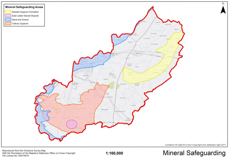
15. Infrastructure and Developer Contributions
Policy 43 Planning Obligations Threshold
Planning obligations may be sought from developments of more than 10 dwellings or 1,000 square metres or more gross floorspace for the provision, improvement or maintenance, where relevant, of the following infrastructure:
- Health;
- Community and sports facilities;
- Green Infrastructure and recreational open space;
- Biodiversity Mitigation and compensation;
- Education; and
- Highways, including sustainable transport measures.
Justification
15.1 Policy 19 of Local Plan Part 1: Core Strategy states that new development will be expected to meet the reasonable cost of new infrastructure required as a consequence of the proposal. In line with Core Strategy Policy 19, the Council is still committed to introducing a Community Infrastructure Levy within the lifetime of this plan. However, some infrastructure requirements will still have
to be provided for as planning obligations (developer contributions). A planning obligation is a legally enforceable obligation entered into under section 106 of the Town and Country Planning Act 1990 to mitigate the impacts of a development proposal.
15.2 Where relevant, planning obligations for supporting infrastructure will be sought on development proposals of more than 10 dwellings or on developments of more than 1,000 square metres gross floorspace, where they are necessary to make the development acceptable in planning terms, directly related to the development, and fairly and reasonably related in scale and kind to the development. The purpose of setting the threshold at this level is so as not to overburden smaller developments with a requirement to make financial contributions towards new infrastructure. It is the Government’s view that local planning authorities should not place a disproportionate burden of developer contributions on small-scale developers and custom and self-builders. Planning obligations in respect of affordable housing provision are subject to Core Strategy Policy 8.
15.3 The Infrastructure Delivery Plans (IDP) that support the Core Strategy and Local Plan Part 2 identify infrastructure requirements both at a strategic level and at a site-specific level. The IDP, together with responses received from infrastructure providers to planning applications, will be used when negotiating planning obligations.
Appendices
Appendix A: Glossary
Affordable Housing - Social rented, affordable rented and intermediate housing, provided to eligible households whose needs are not met by the market. Eligibility is determined with regard to local incomes and local house prices. Affordable housing should include provisions to remain at an affordable price for future eligible households or for the subsidy to be recycled for alternative affordable housing provision.
- Social rented housing is owned by local authorities and private registered providers (as defined in section 80 of the Housing and Regeneration Act 2008), for which guideline target rents are determined through the national rent regime. It may also be owned by other persons and provided under equivalent rental arrangements to the above, as agreed with the local authority or with the Homes England.
- Affordable rented housing is let by local authorities or private registered providers of social housing to households who are eligible for social rented housing. Affordable Rent is subject to rent controls that require a rent of no more than 80% of the local market rent (including service charges, where applicable).
- Intermediate housing is homes for sale and rent provided at a cost above social rent, but below market levels subject to the criteria in the Affordable Housing definition above. These can include shared equity (shared ownership and equity loans), other low cost homes for sale and intermediate rent, but not affordable rented housing.
- Homes that do not meet the above definition of affordable housing, such as “low cost market” housing, may not be considered as affordable housing for planning purposes.
Allocation – Land identified as appropriate for a specific land use.
Appropriate Assessment – A stage in a Habitats Regulations Assessment (see separate entry) required when screening cannot rule out the possibility of a significant effect on a European nature conservation site. The Appropriate Appraisal will determine whether there is a significant effect, if there is, its nature, and whether it can be mitigated.
B1, B2 and B8 (employment) use classes
- B1 Business – (a) Offices (other than those that fall within Use Class A2), (b) research and development of products and processes, and (c) light industry appropriate in a residential area;
- B2 General industrial - Use for an industrial process other than one falling within class B1 (excluding incineration purposes, chemical treatment or landfill or hazardous waste); and
- B8 Storage or distribution (this class includes open air storage).
Biodiversity – The range of life forms which constitute the living world, from microscopic organisms to the largest tree or animal, and the habitat and ecosystem in which they live.
Biodiversity Action Plan – an internationally recognised program addressing threatened species and habitats and is designed to protect and restore biological systems.
Brownfield Land – A general term used to describe land which has been previously developed or built upon. (See previously Developed Land).
Centres of Neighbourhood Importance – these typically consist of a small parade of shops serving walkable local communities.
Conservation (of the built environment) – The process of maintaining and managing change to a heritage asset in a way that sustains and, where appropriate, enhances its significance.
Community Infrastructure Levy (CIL) - A standard financial payment by developers to councils towards the cost of local and sub-regional infrastructure to support development (including transport, social and environmental infrastructure, schools and parks). Use of a CIL would substantially replace the use of S106 agreements (see definition below).
Conservation Area – An area designated by the Local Planning Authority under Section 69 of the Planning (Listed Buildings and Conservation Areas) Act 1990, regarded as being an area of special architectural or historic interest, the character or appearance of which it is desirable to preserve or enhance.
Core Strategy – The key Development Plan Document, setting out the long term spatial vision for the area, the spatial objectives and strategic policies to deliver that vision.
Countryside – The rural parts of Rushcliffe lying outside the main built up area of Nottingham and other larger settlements. Countryside is sometimes taken to exclude land designated as Green Belt (see definition below).
Density – The intensity of development in a given area. Usually measured as net dwelling density, calculated by including only those site areas which will be developed for housing and directly associated uses, including access roads within the site, private garden space, car parking areas, incidental open space and landscaping and children’s play areas, where these are provided.
Designated Heritage Asset – A World Heritage site, Scheduled Monument, Listed Building, Protected Wreck Site, Registered Park and Garden, Registered Battlefield or Conservation Area designated as such under the relevant legislation.
Development Plan – This includes adopted Local Plans and saved policies from Local Plans, and the London Plan, and is defined in section 38 of the Planning and Compulsory Purchase Act 2004.
Development Plan Document (DPD) – A spatial planning document which is part of the Local Plan, subject to extensive consultation and independent examination.
District Centre – These will usually comprise groups of shops often containing at least one supermarket or superstore, and a range of non-retail services, such as banks, building societies and restaurants, as well as local public facilities such as a library.
Edge of Centre – For retail purposes, a location that is well connected and up to 300 metres of the primary shopping area. For all other main town centre uses, allocation within 300 metres of a town centre boundary. For office development, this includes locations outside the town centre but within 500 metres of a public transport interchange. In determining whether a site falls within the definition of edge of centre, account should be taken of local circumstances.
Equality Impact Assessment – A management tool that makes sure that policies and working practices do not discriminate against certain groups and that opportunities are taken to promote equality.
Evidence Base – The information and data that have informed the development of policies. To be sound a document needs to be founded on a robust and credible evidence base.
Exception Test – If, following application of the Sequential Test (see below), it is not possible, consistent with wider sustainability objectives, for the development to be located in flood risk zones with a lower probability of flooding, the Exception Test can be applied if appropriate to show that development provides wider sustainability benefits and development will be safe (more explanation of the Exception Test is set out in national planning guidance).
Flood Plain – Generally low lying areas adjacent to a watercourse, where water flows in times of flood or would flow but for the presence of flood defences.
Greater Nottingham – Area covered by whole council areas of Broxtowe, Erewash, Gedling, Nottingham City and Rushcliffe.
Green Belt – An area of land around a City having five distinct purposes (as set out in the National Planning Policy Framework):
- to check the unrestricted sprawl of large built up areas;
- to prevent neighbouring towns from merging into one another;
- to assist in safeguarding the countryside from encroachment;
- to preserve the setting and special character of historic towns; and
- to assist in urban regeneration by encouraging the recycling of derelict and other urban land.
Green Infrastructure – A network of multi-functional green space, urban and rural, which is capable of delivering a wide range of environmental and quality of life benefits for local communities (taken from National Planning Policy Framework).
Green Space – A subset of open space, consisting of any vegetated land or structure, water or geological feature within urban areas.
Hectare (Ha/ha) – An area 10,000 sq. metres or 2.471 acres.
Heritage Asset – A building, monument, site or landscape of historic, archaeological, architectural or artistic interest, whether designated or not, that is a component of the historic environment. They include designated heritage assets and assets identified by the local planning authority during the process of decision-making or through the plan-making process (including local listing).
Historic Environment – All aspects of the environment resulting from the interaction between people and places through time, including all surviving physical remains of past human activity, whether visible, buried or submerged, and landscaped and planted or managed flora. Those elements of the historic environment that hold significance are called heritage assets.
Infrastructure Delivery Plan (IDP) – The Infrastructure Delivery Plan set out the range of infrastructure required to support the Core Strategies and wider Local Development Framework. The IDP set out infrastructure projects which are critical to the successful delivery of the Core Strategies including when they are needed and how they will be funded and delivered
Issues and Options – An informal early stage of Local Plan preparation, aimed at engaging the public and stakeholders in formulating the main issues that the Local Plan should address, and the options available to deal with those issues.
Key Settlements – Settlements which will experience growth in line with the Spatial Strategy set out in Policy 3 of the Core Strategy.
Listed Buildings – A building of special architectural or historic interest. Listed buildings are graded I, II* or II with grade I being the highest. Listing includes the interior as well as the exterior of the building, and any buildings or permanent structures (e.g. wells within its curtilage). English Heritage is responsible for designating buildings for listing in England.
Local Centres – These will include a range of small shops of a local nature, serving a small catchment. Typically, local centres might include, amongst other shops, a small supermarket, a newsagent, a sub-post office and a pharmacy. In rural areas, large villages may perform the role of a local centre.
Local Nature Reserve (LNR) – Non-statutory habitats of local significance designated by a Local Authority where protection and public understanding of nature conservation is encouraged. Established by a Local Authority under the powers of the National Parks and Access to the Countryside Act 1949.
Local Plan – A single Development Plan Document (DPD) or portfolio of DPDs which set out the spatial strategy for development in the local authority area and detailed policies and proposals to deliver this strategy
Local Wildlife Site (LWS) – A non-statutory designation used to identify high quality wildlife sites in the Borough. They include semi-natural habitats such as ancient woodland and flower-rich grassland.
Main built up area of Nottingham – The main built up area of Nottingham includes West Bridgford, Clifton, Beeston, Stapleford, Long Eaton, Bulwell, Arnold and Carlton (the same as PUA).
Main town centre uses – Retail development (including warehouse clubs and factory outlet centres), leisure, entertainment facilities the more intensive sport and recreation uses (including cinemas, restaurants, drive-through restaurants, bars and pubs, night-clubs, casinos, health and fitness centres, indoor bowling centres, and bingo halls); offices; and arts, culture and tourism development (including theatres, museums, galleries and concert halls, hotels and conference facilities).
National Planning Policy Framework (NPPF) – replaces all other national planning policy documents (PPG/PPS) and many circulars, streamlining them all into one document. It sets out the Government’s planning policies for England and how these are expected to be applied. It provides a framework within which local and neighbourhood plans can be produced reflecting the needs and priorities of the local area.
National Planning Practice Guidance (NPPG) – the Government’s online tool providing guidance on the application and interpretation of national planning policy.
Neighbourhood Plan – A development plan prepared by a local parish council or neighbourhood forum for a designated area. It can set which set out where new houses, businesses and shops should go – and what they should look like. Such plans need to be in general conformity with the strategic policies in the development plan for the area.
Open Space – All open space of public value, including not just land, but also areas of water (such as rivers, canals, lakes and reservoirs) which offer important opportunities for sport and recreation and can act as a visual amenity.
Out of centre – A location which is not in or on the edge of a centre but not necessarily outside the urban area.
Previously Developed Land (PDL) – (often described as Brownfield Land) land which has; is or was occupied by a permanent structure, including the curtilage of the development land (although it should not be assumed that the whole of the curtilage should be developed) and any associated fixed surface infrastructure. This excludes land that is or has been occupied by agricultural or forestry buildings; land that has been developed for minerals extraction or waste disposal by landfill purposes where provision for restoration has been made through development control procedures; land in built-up areas such as private residential gardens, parks, recreation grounds and allotments; and land that was previously-developed but where the remains of the permanent structure or fixed surface structure have blended into the landscape in the process of time
Rural Area – Those parts of greater Nottingham identified as Green Belt or Countryside. For the purposes of affordable housing provision, rural areas include small rural settlements. These are defined as villages/parishes with a population of 3,000 or less and are specifically designated under Section 17 of the Housing Act 1996.
Section 106 Agreement (s106) – Section 106 (s106) of the Town and Country Planning Act 1990 allows a Local Planning Authority to enter into a legally binding agreement or planning obligation with a landowner in association with the grant of planning permission. This agreement is a way of addressing matters that are necessary to make a development acceptable in planning terms and are used to
support the provision of services and infrastructure, such as highways, recreational facilities, education, health and affordable housing. Use of s106 agreements would be substantially replaced by the use of a Community Infrastructure Levy, if implemented (see definition above).
Sequential Test – In the context of flood risk, it is a test to help steer new development to areas with the lowest probability of flooding.
Site of Special Scientific Interest (SSSI) – The designation under Section 28 of the Wildlife and Countryside Act, 1981, of an area of land of special interest by reason of its flora, fauna, geological or physiological features.
Soundness (tests) – Criteria which the Core Strategy must meet if it is be found sound by the Planning Inspectorate. Only Core Strategies which pass the test of soundness can be adopted.
Spatial Objectives – Principles by which the Spatial Vision will be delivered.
Spatial Planning – Spatial planning goes beyond traditional land use planning to bring together and integrate policies for the development and use of land with other policies and programmes which influence the nature of places and how they function. This will include policies which can impact on land use by influencing the demands on, or needs for, development, but which are not capable of being delivered solely or mainly through the granting or refusal of planning permission and which may be implemented by other means.
Spatial Objectives – Principles by which the Spatial Vision will be delivered.
Spatial Vision – A brief description of how the area will be changed at the end of a plan period.
Strategic Environmental Assessment (SEA) – A procedure (set out in the Environmental Assessment of Plans and Programmes 2004) which are likely to have significant effects on the environment.
Strategic Housing Land Availability Assessment (SHLAA) – Document with the role of identifying sites with potential for housing, assessing their housing potential and assessing when they are likely to be developed. Strategic Housing Land Availability Assessment webpage.
Strategic Sites – Sites within the Core Strategy for strategically important employment or housing development and are all ‘allocated’ for development.
Sustainability Appraisal (SA) – Examines the social, environmental and economic effects of strategies and policies in a Local Development Document from the outset of its preparation.
Strategic Flood Risk Assessments (SFRAs) – Assessment used to refine information on areas that may flood, taking into account all sources of flooding and the impacts of climate change. Used to determine the variations in flood risk from all sources of flooding across and from their area. SFRAs should form the basis for preparing appropriate policies for flood risk management.
Sustainable Development – The National Planning Policy Framework refers to Resolution 42/187 of the United Nations General Assembly which defined sustainable development as meeting the needs of the present without compromising the ability of future generations to meet their own needs.
Supplementary Planning Document (SPD) – Documents which add further detail to the policies in the Local Plan. They can be used to provide further guidance for development on specific sites, or on particular issues, such as design. Supplementary planning documents are capable of being a material consideration in planning decisions but are not part of the development plan.
Sustainability Appraisal (SA) – Examines the social, environmental and economic effects of strategies and policies in a Local development Document from the outset of its preparation.
Sustainable Drainage Systems (SuDs) – the system of control of surface water run-off, designed to reduce the potential impact of new and existing developments with respect of surface water drainage discharge.
Windfall Site – Sites which have not been specifically identified as available in the local plan process. They normally comprise previously-developed sites that have unexpectedly become available.
Appendix B: Housing Trajectory
Completions on non-allocated sites and identified SHLAA capacity
Completions
-
- 2011/12: 293
- 2012/13: 203
- 2013/14: 199
- 2014/15: 373
- 2015/16: 375
- 2016/17: 338
- 2017/18: 343
Future years
-
- 2018/19: 326
- 2019/20: 507
- 2020/21: 152
- 2021/22: 62
- 2022/23: 0
- 2023/24: 43
- 2024/25: 32
- 2025/26: 1
- 2026/27: 1
- 2027/28: 0
- 2028/29 (beyond plan period): 20
- 2029/30 (beyond plan period): 20
- 2030/31 (beyond plan period): 10
- 2031/32 (beyond plan period): 0
- 2032/33 (beyond plan period): 0
- Total 2011/28 (plan period): 3,254
- Total 2028/33 (beyond plan period): 50
Land at Melton Road, Edwalton (1,500) (Policy 20)
Completions
-
- 2011/12: -
- 2012/13: -
- 2013/14: -
- 2014/15: -
- 2015/16: -
- 2016/17: 40
- 2017/18: 126
Future years
-
- 2018/19: 250
- 2019/20: 250
- 2020/21: 200
- 2021/22: 200
- 2022/23: 200
- 2023/24: 150
- 2024/25: 150
- 2025/26: 50
- 2026/27: -
- 2027/28: -
- 2028/29 (beyond plan period): -
- 2029/30 (beyond plan period): -
- 2030/31 (beyond plan period): -
- 2031/32 (beyond plan period): -
- 2032/33 (beyond plan period): -
- Total 2011/28 (plan period): 1,616
- Total 2028/33 (beyond plan period): 0
Land at former Cotgrave Colliery, Cotgrave (450) (Policy 21)
Completions
-
- 2011/12: -
- 2012/13: -
- 2013/14: -
- 2014/15: -
- 2015/16: 112
- 2016/17: 150
- 2017/18: 124
Future years
-
- 2018/19: 77
- 2019/20: -
- 2020/21: -
- 2021/22: -
- 2022/23: -
- 2023/24: -
- 2024/25: -
- 2025/26: -
- 2026/27: -
- 2027/28: -
- 2028/29 (beyond plan period): -
- 2029/30 (beyond plan period): -
- 2030/31 (beyond plan period): -
- 2031/32 (beyond plan period): -
- 2032/33 (beyond plan period): -
- Total 2011/28 (plan period): 463
- Total 2028/33 (beyond plan period): 0
Land at former RAF Newton Phase 2 (550) (Policy 22)
Completions
-
- 2011/12: -
- 2012/13: -
- 2013/14: -
- 2014/15: -
- 2015/16: -
- 2016/17: -
- 2017/18: -
Future years
-
- 2018/19: -
- 2019/20: 50
- 2020/21: 100
- 2021/22: 150
- 2022/23: 150
- 2023/24: 100
- 2024/25: -
- 2025/26: -
- 2026/27: -
- 2027/28: -
- 2028/29 (beyond plan period): -
- 2029/30 (beyond plan period): -
- 2030/31 (beyond plan period): -
- 2031/32 (beyond plan period): -
- 2032/33 (beyond plan period): -
- Total 2011/28 (plan period): 550
- Total 2028/33 (beyond plan period): 0
Land north of Bingham (1,050) (Policy 23)
Completions
-
- 2011/12: -
- 2012/13: -
- 2013/14: -
- 2014/15: -
- 2015/16: -
- 2016/17: -
- 2017/18: -
Future years
-
- 2018/19: 25
- 2019/20: 125
- 2020/21: 150
- 2021/22: 150
- 2022/23: 150
- 2023/24: 150
- 2024/25: 150
- 2025/26: 150
- 2026/27: -
- 2027/28: -
- 2028/29 (beyond plan period): -
- 2029/30 (beyond plan period): -
- 2030/31 (beyond plan period): -
- 2031/32 (beyond plan period): -
- 2032/33 (beyond plan period): -
- Total 2011/28 (plan period): 1,050
- Total 2028/33 (beyond plan period): 0
Land south of Clifton (3,000) (Policy 24)
Completions
-
- 2011/12: -
- 2012/13: -
- 2013/14: -
- 2014/15: -
- 2015/16: -
- 2016/17: -
- 2017/18: -
Future years
-
- 2018/19: -
- 2019/20: -
- 2020/21: 50
- 2021/22: 200
- 2022/23: 250
- 2023/24: 250
- 2024/25: 250
- 2025/26: 250
- 2026/27: 250
- 2027/28: 250
- 2028/29 (beyond plan period): 250
- 2029/30 (beyond plan period): 250
- 2030/31 (beyond plan period): 250
- 2031/32 (beyond plan period): 250
- 2032/33 (beyond plan period): 250
- Total 2011/28 (plan period): 1,750
- Total 2028/33 (beyond plan period): 1,250
East of Gamston/North of Tollerton (2-500 to 4,000) (Policy 25)
Completions
-
- 2011/12: -
- 2012/13: -
- 2013/14: -
- 2014/15: -
- 2015/16: -
- 2016/17: -
- 2017/18: -
Future years
-
- 2018/19: -
- 2019/20: -
- 2020/21: -
- 2021/22: 50
- 2022/23: 200
- 2023/24: 250
- 2024/25: 250
- 2025/26: 250
- 2026/27: 250
- 2027/28: 250
- 2028/29 (beyond plan period): 250
- 2029/30 (beyond plan period): 250
- 2030/31 (beyond plan period): 250
- 2031/32 (beyond plan period): 250
- 2032/33 (beyond plan period): 250
- Total 2011/28 (plan period): 1,500
- Total 2028/33 (beyond plan period): 1,250
Infill and changes of use in broad location
Completions
-
- 2011/12: -
- 2012/13: -
- 2013/14: -
- 2014/15: -
- 2015/16: -
- 2016/17: -
- 2017/18: -
Future years
-
- 2018/19: -
- 2019/20: -
- 2020/21: -
- 2021/22: 104
- 2022/23: 104
- 2023/24: 104
- 2024/25: 104
- 2025/26: 104
- 2026/27: 104
- 2027/28: 104
- 2028/29 (beyond plan period): 78
- 2029/30 (beyond plan period): 78
- 2030/31 (beyond plan period): 78
- 2031/32 (beyond plan period): 78
- 2032/33 (beyond plan period): 78
- Total 2011/28 (plan period): 728
- Total 2028/33 (beyond plan period): 390
Land rear of Mill Lane/The Old Park Cotgrave
Completions
-
- 2011/12: -
- 2012/13: -
- 2013/14: -
- 2014/15: -
- 2015/16: -
- 2016/17: -
- 2017/18: -
Future years
-
- 2018/19: -
- 2019/20: -
- 2020/21: 50
- 2021/22: 50
- 2022/23: 50
- 2023/24: 30
- 2024/25: -
- 2025/26: -
- 2026/27: -
- 2027/28: -
- 2028/29 (beyond plan period): -
- 2029/30 (beyond plan period): -
- 2030/31 (beyond plan period): -
- 2031/32 (beyond plan period): -
- 2032/33 (beyond plan period): -
- Total 2011/28 (plan period): 180
- Total 2028/33 (beyond plan period): 0
Land south of Hollygate Lane, Cotgrave
Completions
-
- 2011/12: -
- 2012/13: -
- 2013/14: -
- 2014/15: -
- 2015/16: -
- 2016/17: -
- 2017/18: -
Future years
-
- 2018/19: -
- 2019/20: -
- 2020/21: 50
- 2021/22: 50
- 2022/23: 50
- 2023/24: 40
- 2024/25: -
- 2025/26: -
- 2026/27: -
- 2027/28: -
- 2028/29 (beyond plan period): -
- 2029/30 (beyond plan period): -
- 2030/31 (beyond plan period): -
- 2031/32 (beyond plan period): -
- 2032/33 (beyond plan period): -
- Total 2011/28 (plan period): 190
- Total 2028/33 (beyond plan period): 0
Land north of Rempstone Road, East Leake
Completions
-
- 2011/12: -
- 2012/13: -
- 2013/14: -
- 2014/15: -
- 2015/16: -
- 2016/17: -
- 2017/18: -
Future years
-
- 2018/19: -
- 2019/20: 50
- 2020/21: 50
- 2021/22: 50
- 2022/23: 50
- 2023/24: 35
- 2024/25: -
- 2025/26: -
- 2026/27: -
- 2027/28: -
- 2028/29 (beyond plan period): -
- 2029/30 (beyond plan period): -
- 2030/31 (beyond plan period): -
- 2031/32 (beyond plan period): -
- 2032/33 (beyond plan period): -
- Total 2011/28 (plan period): 235
- Total 2028/33 (beyond plan period): -
Land north of Lantern Road, East Leake
Completions
-
- 2011/12: -
- 2012/13: -
- 2013/14: -
- 2014/15: -
- 2015/16: -
- 2016/17: -
- 2017/18: -
Future years
-
- 2018/19: -
- 2019/20: -
- 2020/21: 50
- 2021/22: 50
- 2022/23: 50
- 2023/24: 45
- 2024/25: -
- 2025/26: -
- 2026/27: -
- 2027/28: -
- 2028/29 (beyond plan period): -
- 2029/30 (beyond plan period): -
- 2030/31 (beyond plan period): -
- 2031/32 (beyond plan period): -
- 2032/33 (beyond plan period): -
- Total 2011/28 (plan period): 95
- Total 2028/33 (beyond plan period): -
Land off Nicker Hill, Keyworth
Completions
-
- 2011/12: -
- 2012/13: -
- 2013/14: -
- 2014/15: -
- 2015/16: -
- 2016/17: -
- 2017/18: -
Future years
-
- 2018/19: -
- 2019/20: -
- 2020/21: 50
- 2021/22: 50
- 2022/23: 50
- 2023/24: -
- 2024/25: -
- 2025/26: -
- 2026/27: -
- 2027/28: -
- 2028/29 (beyond plan period): -
- 2029/30 (beyond plan period): -
- 2030/31 (beyond plan period): -
- 2031/32 (beyond plan period): -
- 2032/33 (beyond plan period): -
- Total 2011/28 (plan period): 150
- Total 2028/33 (beyond plan period): -
Land between Platt Lane and Station Road, Keyworth
Completions
-
- 2011/12: -
- 2012/13: -
- 2013/14: -
- 2014/15: -
- 2015/16: -
- 2016/17: -
- 2017/18: -
Future years
-
- 2018/19: -
- 2019/20: -
- 2020/21: 50
- 2021/22: 50
- 2022/23: 50
- 2023/24: 40
- 2024/25: -
- 2025/26: -
- 2026/27: -
- 2027/28: -
- 2028/29 (beyond plan period): -
- 2029/30 (beyond plan period): -
- 2030/31 (beyond plan period): -
- 2031/32 (beyond plan period): -
- 2032/33 (beyond plan period): -
- Total 2011/28 (plan period): 190
- Total 2028/33 (beyond plan period): -
Land south of Debdale Lane
Completions
-
- 2011/12: -
- 2012/13: -
- 2013/14: -
- 2014/15: -
- 2015/16: -
- 2016/17: -
- 2017/18: -
Future years
-
- 2018/19: -
- 2019/20: -
- 2020/21: 50
- 2021/22: 50
- 2022/23: 50
- 2023/24: 40
- 2024/25: -
- 2025/26: -
- 2026/27: -
- 2027/28: -
- 2028/29 (beyond plan period): -
- 2029/30 (beyond plan period): -
- 2030/31 (beyond plan period): -
- 2031/32 (beyond plan period): -
- 2032/33 (beyond plan period): -
- Total 2011/28 (plan period): 190
- Total 2028/33 (beyond plan period): -
Hillside Farm, Keyworth
Completions
-
- 2011/12: -
- 2012/13: -
- 2013/14: -
- 2014/15: -
- 2015/16: -
- 2016/17: -
- 2017/18: -
Future years
-
- 2018/19: -
- 2019/20: -
- 2020/21: 25
- 2021/22: 45
- 2022/23: -
- 2023/24: -
- 2024/25: -
- 2025/26: -
- 2026/27: -
- 2027/28: -
- 2028/29 (beyond plan period): -
- 2029/30 (beyond plan period): -
- 2030/31 (beyond plan period): -
- 2031/32 (beyond plan period): -
- 2032/33 (beyond plan period): -
- Total 2011/28 (plan period): 70
- Total 2028/33 (beyond plan period): -
Land north of Nottingham Road, Radcliffe on Trent
Completions
-
- 2011/12: -
- 2012/13: -
- 2013/14: -
- 2014/15: -
- 2015/16: -
- 2016/17: -
- 2017/18: -
Future years
-
- 2018/19: -
- 2019/20: -
- 2020/21: 50
- 2021/22: 50
- 2022/23: 50
- 2023/24: -
- 2024/25: -
- 2025/26: -
- 2026/27: -
- 2027/28: -
- 2028/29 (beyond plan period): -
- 2029/30 (beyond plan period): -
- 2030/31 (beyond plan period): -
- 2031/32 (beyond plan period): -
- 2032/33 (beyond plan period): -
- Total 2011/28 (plan period): 150
- Total 2028/33 (beyond plan period): -
Land adjacent to Grooms Cottage, Radcliffe on Trent
Completions
-
- 2011/12: -
- 2012/13: -
- 2013/14: -
- 2014/15: -
- 2015/16: -
- 2016/17: -
- 2017/18: -
Future years
-
- 2018/19: -
- 2019/20: -
- 2020/21: -
- 2021/22: 25
- 2022/23: 25
- 2023/24: -
- 2024/25: -
- 2025/26: -
- 2026/27: -
- 2027/28: -
- 2028/29 (beyond plan period): -
- 2029/30 (beyond plan period): -
- 2030/31 (beyond plan period): -
- 2031/32 (beyond plan period): -
- 2032/33 (beyond plan period): -
- Total 2011/28 (plan period): 50
- Total 2028/33 (beyond plan period): -
Land off Shelford Road, Radcliffe on Trent
Completions
-
- 2011/12: -
- 2012/13: -
- 2013/14: -
- 2014/15: -
- 2015/16: -
- 2016/17: -
- 2017/18: -
Future years
-
- 2018/19: -
- 2019/20: 50
- 2020/21: 50
- 2021/22: 50
- 2022/23: 50
- 2023/24: 50
- 2024/25: 50
- 2025/26: 50
- 2026/27: 50
- 2027/28: -
- 2028/29 (beyond plan period): -
- 2029/30 (beyond plan period): -
- 2030/31 (beyond plan period): -
- 2031/32 (beyond plan period): -
- 2032/33 (beyond plan period): -
- Total 2011/28 (plan period): 400
- Total 2028/33 (beyond plan period): -
Land north of Grantham Road, Radcliffe on Trent
Completions
-
- 2011/12: -
- 2012/13: -
- 2013/14: -
- 2014/15: -
- 2015/16: -
- 2016/17: -
- 2017/18: -
Future years
-
- 2018/19: -
- 2019/20: -
- 2020/21: 50
- 2021/22: 50
- 2022/23: 50
- 2023/24: 50
- 2024/25: 40
- 2025/26: -
- 2026/27: -
- 2027/28: -
- 2028/29 (beyond plan period): -
- 2029/30 (beyond plan period): -
- 2030/31 (beyond plan period): -
- 2031/32 (beyond plan period): -
- 2032/33 (beyond plan period): -
- Total 2011/28 (plan period): 240
- Total 2028/33 (beyond plan period): -
72 Main Road, Radcliffe on Trent
Completions
-
- 2011/12: -
- 2012/13: -
- 2013/14: -
- 2014/15: -
- 2015/16: -
- 2016/17: -
- 2017/18: -
Future years
-
- 2018/19: -
- 2019/20: -
- 2020/21: 1
- 2021/22: 1
- 2022/23: 2
- 2023/24: -
- 2024/25: -
- 2025/26: -
- 2026/27: -
- 2027/28: -
- 2028/29 (beyond plan period): -
- 2029/30 (beyond plan period): -
- 2030/31 (beyond plan period): -
- 2031/32 (beyond plan period): -
- 2032/33 (beyond plan period): -
- Total 2011/28 (plan period): 5
- Total 2028/33 (beyond plan period): -
The Paddocks, Nottingham Road, Radcliffe on Trent
Completions
-
- 2011/12: -
- 2012/13: -
- 2013/14: -
- 2014/15: -
- 2015/16: -
- 2016/17: -
- 2017/18: -
Future years
-
- 2018/19: -
- 2019/20: -
- 2020/21: -
- 2021/22: -
- 2022/23: -
- 2023/24: -
- 2024/25: 50
- 2025/26: 25
- 2026/27: -
- 2027/28: -
- 2028/29 (beyond plan period): -
- 2029/30 (beyond plan period): -
- 2030/31 (beyond plan period): -
- 2031/32 (beyond plan period): -
- 2032/33 (beyond plan period): -
- Total 2011/28 (plan period): 75
- Total 2028/33 (beyond plan period): -
Land west of Wilford Road, Ruddington
Completions
-
- 2011/12: -
- 2012/13: -
- 2013/14: -
- 2014/15: -
- 2015/16: -
- 2016/17: -
- 2017/18: -
Future years
-
- 2018/19: -
- 2019/20: -
- 2020/21: -
- 2021/22: 50
- 2022/23: 50
- 2023/24: 30
- 2024/25: -
- 2025/26: -
- 2026/27: -
- 2027/28: -
- 2028/29 (beyond plan period): -
- 2029/30 (beyond plan period): -
- 2030/31 (beyond plan period): -
- 2031/32 (beyond plan period): -
- 2032/33 (beyond plan period): -
- Total 2011/28 (plan period): 130
- Total 2028/33 (beyond plan period): -
Land south of Flawforth Lane, Ruddington
Completions
-
- 2011/12: -
- 2012/13: -
- 2013/14: -
- 2014/15: -
- 2015/16: -
- 2016/17: -
- 2017/18: -
Future years
-
- 2018/19: -
- 2019/20: -
- 2020/21: 25
- 2021/22: 25
- 2022/23: -
- 2023/24: -
- 2024/25: -
- 2025/26: -
- 2026/27: -
- 2027/28: -
- 2028/29 (beyond plan period): -
- 2029/30 (beyond plan period): -
- 2030/31 (beyond plan period): -
- 2031/32 (beyond plan period): -
- 2032/33 (beyond plan period): -
- Total 2011/28 (plan period): 50
- Total 2028/33 (beyond plan period): -
Land opposite Mere Way, Ruddington
Completions
-
- 2011/12: -
- 2012/13: -
- 2013/14: -
- 2014/15: -
- 2015/16: -
- 2016/17: -
- 2017/18: -
Future years
-
- 2018/19: -
- 2019/20: -
- 2020/21: 20
- 2021/22: 50
- 2022/23: 50
- 2023/24: 50
- 2024/25: -
- 2025/26: -
- 2026/27: -
- 2027/28: -
- 2028/29 (beyond plan period): -
- 2029/30 (beyond plan period): -
- 2030/31 (beyond plan period): -
- 2031/32 (beyond plan period): -
- 2032/33 (beyond plan period): -
- Total 2011/28 (plan period): 170
- Total 2028/33 (beyond plan period): -
Land at Asher Lane, Ruddington
Completions
-
- 2011/12: -
- 2012/13: -
- 2013/14: -
- 2014/15: -
- 2015/16: -
- 2016/17: -
- 2017/18: -
Future years
-
- 2018/19: -
- 2019/20: -
- 2020/21: 50
- 2021/22: 50
- 2022/23: 50
- 2023/24: 25
- 2024/25: -
- 2025/26: -
- 2026/27: -
- 2027/28: -
- 2028/29 (beyond plan period): -
- 2029/30 (beyond plan period): -
- 2030/31 (beyond plan period): -
- 2031/32 (beyond plan period): -
- 2032/33 (beyond plan period): -
- Total 2011/28 (plan period): 175
- Total 2028/33 (beyond plan period): -
Land east of Church Street, Cropwell Bishop
Completions
-
- 2011/12: -
- 2012/13: -
- 2013/14: -
- 2014/15: -
- 2015/16: -
- 2016/17: -
- 2017/18: -
Future years
-
- 2018/19: -
- 2019/20: -
- 2020/21: 25
- 2021/22: 45
- 2022/23: -
- 2023/24: -
- 2024/25: -
- 2025/26: -
- 2026/27: -
- 2027/28: -
- 2028/29 (beyond plan period): -
- 2029/30 (beyond plan period): -
- 2030/31 (beyond plan period): -
- 2031/32 (beyond plan period): -
- 2032/33 (beyond plan period): -
- Total 2011/28 (plan period): 70
- Total 2028/33 (beyond plan period): -
Land between Butt Lane and Closes Side Lane, East Bridgford
Completions
-
- 2011/12: -
- 2012/13: -
- 2013/14: -
- 2014/15: -
- 2015/16: -
- 2016/17: -
- 2017/18: -
Future years
-
- 2018/19: -
- 2019/20: -
- 2020/21: 25
- 2021/22: 55
- 2022/23: -
- 2023/24: -
- 2024/25: -
- 2025/26: -
- 2026/27: -
- 2027/28: -
- 2028/29 (beyond plan period): -
- 2029/30 (beyond plan period): -
- 2030/31 (beyond plan period): -
- 2031/32 (beyond plan period): -
- 2032/33 (beyond plan period): -
- Total 2011/28 (plan period): 80
- Total 2028/33 (beyond plan period): -
Land south of Butt Lane, East Bridgford
Completions
-
- 2011/12: -
- 2012/13: -
- 2013/14: -
- 2014/15: -
- 2015/16: -
- 2016/17: -
- 2017/18: -
Future years
-
- 2018/19: -
- 2019/20: -
- 2020/21: 25
- 2021/22: 20
- 2022/23: -
- 2023/24: -
- 2024/25: -
- 2025/26: -
- 2026/27: -
- 2027/28: -
- 2028/29 (beyond plan period): -
- 2029/30 (beyond plan period): -
- 2030/31 (beyond plan period): -
- 2031/32 (beyond plan period): -
- 2032/33 (beyond plan period): -
- Total 2011/28 (plan period): 45
- Total 2028/33 (beyond plan period): -
Land east of Gypsum Way, Gotham
Completions
-
- 2011/12: -
- 2012/13: -
- 2013/14: -
- 2014/15: -
- 2015/16: -
- 2016/17: -
- 2017/18: -
Future years
-
- 2018/19: -
- 2019/20: -
- 2020/21: 20
- 2021/22: 50
- 2022/23: -
- 2023/24: -
- 2024/25: -
- 2025/26: -
- 2026/27: -
- 2027/28: -
- 2028/29 (beyond plan period): -
- 2029/30 (beyond plan period): -
- 2030/31 (beyond plan period): -
- 2031/32 (beyond plan period): -
- 2032/33 (beyond plan period): -
- Total 2011/28 (plan period): 70
- Total 2028/33 (beyond plan period): -
Land north of Park Lane, Sutton Bonington
Completions
-
- 2011/12: -
- 2012/13: -
- 2013/14: -
- 2014/15: -
- 2015/16: -
- 2016/17: -
- 2017/18: -
Future years
-
- 2018/19: -
- 2019/20: -
- 2020/21: -
- 2021/22: -
- 2022/23: 30
- 2023/24: 50
- 2024/25: -
- 2025/26: -
- 2026/27: -
- 2027/28: -
- 2028/29 (beyond plan period): -
- 2029/30 (beyond plan period): -
- 2030/31 (beyond plan period): -
- 2031/32 (beyond plan period): -
- 2032/33 (beyond plan period): -
- Total 2011/28 (plan period): 80
- Total 2028/33 (beyond plan period): -
Former Bunny Brickworks
Completions
-
- 2011/12: -
- 2012/13: -
- 2013/14: -
- 2014/15: -
- 2015/16: -
- 2016/17: -
- 2017/18: -
Future years
-
- 2018/19: -
- 2019/20: -
- 2020/21: -
- 2021/22: -
- 2022/23: -
- 2023/24: -
- 2024/25: 25
- 2025/26: 50
- 2026/27: 25
- 2027/28: -
- 2028/29 (beyond plan period): -
- 2029/30 (beyond plan period): -
- 2030/31 (beyond plan period): -
- 2031/32 (beyond plan period): -
- 2032/33 (beyond plan period): -
- Total 2011/28 (plan period): 100
- Total 2028/33 (beyond plan period): -
Former Islamic Institute, Flintham
Completions
-
- 2011/12: -
- 2012/13: -
- 2013/14: -
- 2014/15: -
- 2015/16: -
- 2016/17: -
- 2017/18: -
Future years
-
- 2018/19: -
- 2019/20: 25
- 2020/21: 50
- 2021/22: 20
- 2022/23: -
- 2023/24: -
- 2024/25: -
- 2025/26: -
- 2026/27: -
- 2027/28: -
- 2028/29 (beyond plan period): -
- 2029/30 (beyond plan period): -
- 2030/31 (beyond plan period): -
- 2031/32 (beyond plan period): -
- 2032/33 (beyond plan period): -
- Total 2011/28 (plan period): 95
- Total 2028/33 (beyond plan period): 0
Projected Completions
Completions
-
- 2011/12:
- 2012/13:
- 2013/14:
- 2014/15:
- 2015/16:
- 2016/17:
- 2017/18:
Future years
-
- 2018/19:
- 2019/20:
- 2020/21:
- 2021/22:
- 2022/23:
- 2023/24:
- 2024/25:
- 2025/26:
- 2026/27:
- 2027/28:
- 2028/29 (beyond plan period):
- 2029/30 (beyond plan period):
- 2030/31 (beyond plan period):
- 2031/32 (beyond plan period):
- 2032/33 (beyond plan period):
- Total 2011/28 (plan period):
- Total 2028/33 (beyond plan period):
Cumulative Completions
Completions
-
- 2011/12:
- 2012/13:
- 2013/14:
- 2014/15:
- 2015/16:
- 2016/17:
- 2017/18:
Future years
-
- 2018/19:
- 2019/20:
- 2020/21:
- 2021/22:
- 2022/23:
- 2023/24:
- 2024/25:
- 2025/26:
- 2026/27:
- 2027/28:
- 2028/29 (beyond plan period):
- 2029/30 (beyond plan period):
- 2030/31 (beyond plan period):
- 2031/32 (beyond plan period):
- 2032/33 (beyond plan period):
Core Strategy annual average requirement
Completions
-
- 2011/12:
- 2012/13:
- 2013/14:
- 2014/15:
- 2015/16:
- 2016/17:
- 2017/18:
Future years
-
- 2018/19:
- 2019/20:
- 2020/21:
- 2021/22:
- 2022/23:
- 2023/24:
- 2024/25:
- 2025/26:
- 2026/27:
- 2027/28:
Core Strategy annual average requirement - cumulative
Completions
-
- 2011/12:
- 2012/13:
- 2013/14:
- 2014/15:
- 2015/16:
- 2016/17:
- 2017/18:
Future years
-
- 2018/19:
- 2019/20:
- 2020/21:
- 2021/22:
- 2022/23:
- 2023/24:
- 2024/25:
- 2025/26:
- 2026/27:
- 2027/28:
Delivery performance (cumulative completions minus cumulative requirement)
Completions
-
- 2011/12:
- 2012/13:
- 2013/14:
- 2014/15:
- 2015/16:
- 2016/17:
- 2017/18:
Future years
-
- 2018/19:
- 2019/20:
- 2020/21:
- 2021/22:
- 2022/23:
- 2023/24:
- 2024/25:
- 2025/26:
- 2026/27:
- 2027/28:
Appendix C: Landscape Sensitivity Study: Wind Energy Development
Landscape sensitivity to wind turbine development (showing sensitivity ratings Low to High)
|
Character Area Code |
Landscape Character Unit (LCU) |
Less than 25m |
26-50m |
51-75m |
76-110m |
111-150m |
|---|---|---|---|---|---|---|
| 1 | Vale of Belvoir (includes part within Melton and part within Rushcliffe) | Low to Medium | Medium | Medium to High | High | High |
| 16 | Nottinghamshire Wolds: Gotham and West Leake Wooded Hills and Scarps | Low | Medium | Medium to High | High | High |
| 17 | Nottinghamshire Wolds: East Leake Rolling Farmland | Low | Medium | Medium to High | High | High |
| 18 | Nottinghamshire Wolds: Widmerpool Clay Wolds (includes part within Melton and part within Rushcliffe) | Low | Medium | Medium | Medium to High | High |
| 19 | Nottinghamshire Wolds: Cotgrave Wooded Clay Wolds | Low | Medium | Medium to High | Medium to High | High |
| 20 | South Nottinghamshire Farmlands: Clifton Slopes | Low to Medium | Medium | Medium to High | Medium to High | High |
| 21 | South Nottinghamshire Farmlands: Ruddington Alluvial Farmland | Low | Low to Medium | Medium | Medium to High | High |
| 22 | South Nottinghamshire Farmlands: Mickleborough Fringe | Low | Low to Medium | Medium | Medium to High | High |
| 23 | South Nottinghamshire Farmlands: East Bridgford Escarpment Farmland | Low | Low to Medium | Medium | Medium to High | High |
| 24 | South Nottinghamshire Farmlands: Cotgrave and Tollerton Village Farmland | Low | Low to Medium | Medium | Medium to High | High |
| 25 | South Nottinghamshire Farmlands: Aslockton Village Farmland | Low | Low to Medium | Medium | Medium to High | High |
| 26 | Trent Valley: Attenborough Wetlands | Low | Low to Medium | Medium | Medium to High | High |
| 27 | Trent Valley: Soar Valley | Low to Medium | Medium | Medium to High | High | High |
| 28 | Trent Washlands: West Bridgford to East Bridgford Washlands | Low | Low to Medium | Medium | Medium to High | High |
Figure C1: Landscape Character Units
Appendix D: Green Infrastructure
Figure D1: Rushcliffe West Green Infrastructure
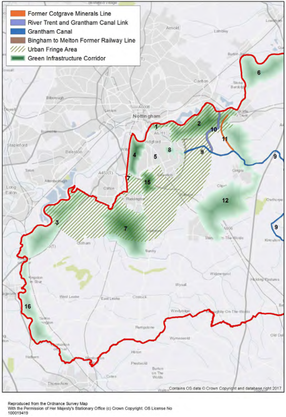
Figure D2: Rushcliffe East Green Infrastructure
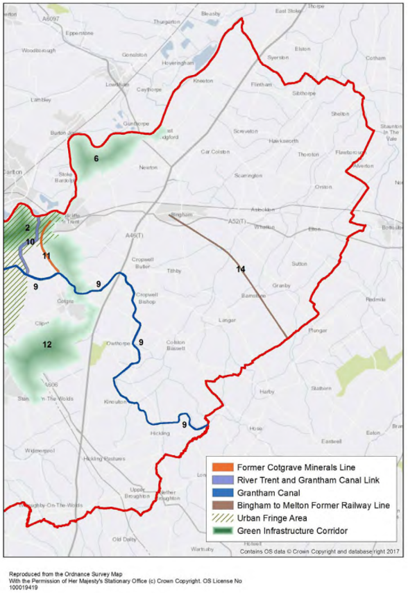
Table D1: Green Infrastructure Corridors
|
Corridor Number |
Habitat Types |
Habitat Objectives |
|---|---|---|
| 1 | West Bridgford/Trent Washlands Green Corridor |
|
| 2 | River Trent - Trent Washlands to Holme Pierrepont (incorporating Holme Pierrepont Country Park and Skylarks Nature Reserve) Green Corridor |
|
| 3 | River Trent (West) – Clifton to Barton-in-Fabis, River Trent and Kegworth Green Corridor |
|
| 4 | River Trent/Wilford/Compton Acres Green Corridor |
|
| 5 | Green Line (Former Melton/Old Dalby/Nottingham Railway Line within West Bridgford) |
|
| 6 | River Trent (East) – Holme Pierrepont to East Bridgford Green Corridor |
|
| 7 | Fairham Brook/ Packman Dyke and Rushcliffe Country Park Green Corridor |
|
| 8 | Abbey Road/Gamston Local Corridors |
|
| 9 | Grantham Canal (River Trent to Cotgrave Country Park, via Ladybay and towards Cropwell Bishop) |
|
| 10 | Proposed Trent to Cotgrave Canal link to West Bridgford – via Polser Brook |
|
| 11 | Cotgrave Disused Railway Line from Cotgrave Country Park to Holme Pierrepont and Adbolton |
|
| 12 | Keyworth/Stanton on the Wolds to Radcliffe on Trent via Cotgrave and Cotgrave Country Park |
|
| 14 | Bingham Linear Walk/Melton Wildlife Corridor |
|
| 15 | Edwalton / Sharphill Wood / Ruddington Corridor |
|
| 16 | River Soar – from River Trent towards Loughborough |
|
Appendix E: Biodiversity Opportunity Areas
Figure E1: Rushcliffe West Ecological Networks (Focal Areas)
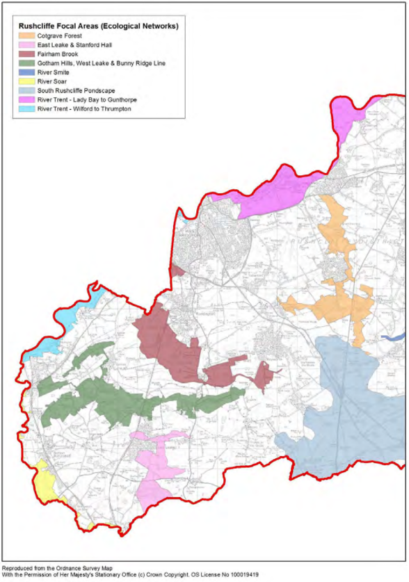
Figure E2: Rushcliffe East Ecological Networks (Focal Areas)
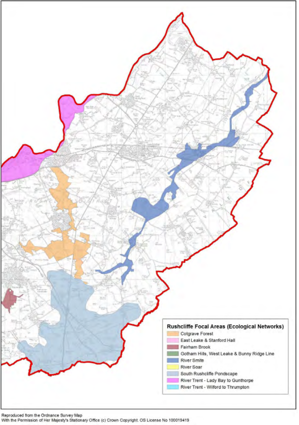
Rushcliffe Ecological Networks (Focal Areas)
|
Ecological Networks (Focal Areas) |
Habitat Types |
Habitat Objectives |
|---|---|---|
| Cotgrave Forest |
|
Improve and extend the existing Development should strengthen |
| East Leake/Stanford Hall |
|
The parkland and grassland at Stanford Hall offer good core habitat. This area would form a southern block to an area that offers opportunities to improve habitat connectivity down the eastern fringes of East Leake and into the Kingston Brook. The focus for this area would be enhancing a mosaic of grassland and wetland habitats. |
| Fairham Brook |
|
Wetland enhancement and grassland creation have been identified between Clifton and the Keyworth Wolds within this focal area. |
| Gotham Hills |
|
Existing network of woodland and grassland can be enhanced and buffered. There is potential for creating important links between existing habitats. |
| River Smite |
|
Corridor along the River Smite, Together these could deliver Water Framework Directive objectives as well as creating new areas of habitat. |
| Soar Valley |
|
Potential for wetland/grassland developments along the whole of the river corridor, but with particular focus on the lowlands around Sutton Bonington. |
| Rushcliffe Pondscape |
|
High concentration of ponds exists in an area bordered by Hickling, Keyworth, Willoughby and the county boundary with Leicestershire. Data suggests Opportunities to maintain and |
| Trent Valley (Lady Bay to Stoke Bardolph) |
|
Potential for improving the wetland and grassland networks in a large block centred on Holme Pierrepont. A number of existing sites have been identified as requiring maintenance, enhancement and buffering. There is also lots of potential for improving habitat connectivity between sites. |
| Trent Valley (Wilford to Thrumpton) |
|
Potential for improving the wetland and grassland networks. A number of existing sites provide good areas of core habitat and the surrounding floodplain offers potential areas where habitat connectivity can be improved. |
Accessible Documents
- Air Quality Action Plan 2021
- Annual Air Quality Reports
- Air Quality Strategy for Nottingham and Notts
- Annual Governance Statements
- Asset Management Strategy
- Become a Councillor 2022
- Budget and Financial Strategy
- Capital and Investment Strategy
- Climate Change Strategy 2021-2030
- Complaints Policy
- Compulsory Purchase Order Procedure Protocol
- Confidential Reporting Code
- Council Constitution
- Contaminated Land
- Corporate Enforcement Policy
- Corporate Strategy 2024-2027
- Council Tax Recovery and Enforcement Policy 2026
- Customer Access Strategy
- Design Code Baseline Appraisal
- Discretionary Housing Payments Policy 2024-2025
- Disabled Facilities Grant Policy
- Disclosure and Barring Service Policy
- Economic Growth Strategy 2024
- Empty Homes Strategy
- Environment Policy 2023
- Equalities Scheme 2021-25
- External Audit Completion Report 2024
- External Audit Completion Report 2023
- External and Internal Communications Strategy
- Freedom Of Information Policy
- HB Recovery and Enforcement Policy
- Homelessness and Rough Sleeping Strategy
- Housing Allocations Policy
- Housing Enforcement Policy
- ICT Strategy 2022 -25
- Information Management and Governance Strategy 2022-25
- Rushcliffe Borough Council Information Retention Schedule
- Internal Audit
- Leisure Strategy 2021-2027 review
- Local Code of Corporate Governance 2026/27
- Local Plan Part 1: Core Strategy
- Local Plan Part 2: Land and Planning Policies
- Local Plan Monitoring Report
- Local Scheme of Validation
- Off-street Car Parking Strategy
- Pay Policy Statement 2026/27
- People Strategy 2021-26
- Planning Enforcement Policy
- Play Strategy
- Procurement Strategy
- 2021-22 Public Inspection Notice
- RIPA Policy and Guidance
- Risk Management Strategy 2026-29
- Rushcliffe Nature Conservation Strategy
- Solar Farm Landscape Sensitivity and Capacity Study
- Statement of Gambling Licensing Principles
- Statement of Accounts
- Statement of Licensing Policy
- Street Trading Policy
- Supplementary Planning Documents
- Tenancy Strategy 2019
- Transformation Strategy and Efficiency Plan
- Tree Management and Protection Policy 2023
- WISE Agreement
- Conservation Areas
- Neighbourhood Plans
- The Nature of Rushcliffe 2021
- The Nature of Rushcliffe 2019
- Anti-Slavery Policy
- Modern Slavery & Human Trafficking Transparency Statement 2024-2025
- Annual Infrastructure Funding Statements
- Anti-Fraud & Corruption Policy 2025
- Communications and Engagement Strategy 2025-28
- Rushcliffe Design Code
- Technology, Digital and Customer Access Strategy
- Rushcliffe Nature Conservation Strategy
- Strategic Housing Land Availability Assessment Report 2024
- Biodiversity Duty Report January 2024 to December 2025
- Hackney Carriage and Private Hire Licensing Policy 2025 - 2030
- Playing Pitch Strategy 2025-28
- Collecting Unpaid Non Domestic Rates - Recovery and Enforcement Policy 2026
- Strategic Housing Land Availability Assessment Report 2025
- Transformation Strategy and Efficiency Plan