Air Quality Annual Status Report 2023
2023 Air Quality Annual Status Report (ASR)
In fulfilment of Part IV of the Environment Act 1995 Local Air Quality Management, as amended by the Environment Act 2021
Information: Rushcliffe Borough Council Details
Local Authority Officer: Caroline McCaffrey
Department: Environmental Health
Address: Rushcliffe Borough Council, Rushcliffe Arena, Rugby Road, West Bridgford, Nottingham, NG2 7YG
Telephone: 0115 981 9911
Email: environmentalhealth@rushcliffe.gov.uk
Report Reference Number: ASR 2023
Date: 30 June 2023
Table of Contents
Executive Summary: Air Quality in Our Area
- Air Quality in Rushcliffe Borough Council
- Actions to Improve Air Quality
- Conclusions and Priorities
- Local Engagement and How to get Involved
- Local Responsibilities and Commitment
1 Local Air Quality Management
2 Actions to Improve Air Quality
- 2.1 Air Quality Management Areas
- 2.2 Progress and Impact of Measures to address Air Quality in Rushcliffe Borough Council
- 2.3 PM2.5 – Local Authority Approach to Reducing Emissions and/or Concentrations
3 Air Quality Monitoring Data and Comparison with Air Quality Objectives and National Compliance
- 3.1 Summary of Monitoring Undertaken
- 3.1.1 Automatic Monitoring Sites
- 3.1.2 Non-Automatic Monitoring Sites
- 3.2 Individual Pollutants
- 3.2.1 Nitrogen Dioxide (NO2)
- 3.2.2 Particulate Matter (PM10)
- 3.2.3 Particulate Matter (PM2.5)
- 3.2.4 Sulphur Dioxide (SO2)
Appendix A: Monitoring Results
Appendix B: Full Monthly Diffusion Tube Results 2022
Appendix C: Supporting Technical Information / Air Quality Monitoring Data QA/QC
New or Changed Sources Identified Within Rushcliffe Borough Council During 2022
Additional Air Quality Works Undertaken by Rushcliffe Borough Council During 2022
QA/QC of Diffusion Tube Monitoring
Diffusion Tube Bias Adjustment Factors
NO2 Fall-off with distance from the road
Automatic Monitoring Annualisation
NO2 Fall-off with distance from the road
Appendix D: Maps of Monitoring Locations and AQMAs
Appendix E: Summary of Air Quality Objectives in England
Executive Summary: Air Quality in Our Area
Air Quality in Rushcliffe Borough Council
Air pollution is associated with a number of adverse health impacts. It is recognised as a contributing factor in the onset of heart disease and cancer. Additionally, air pollution particularly affects the most vulnerable in society: children, the elderly, and those with existing heart and lung conditions. There is also often a strong correlation with equalities issues because areas with poor air quality are also often less affluent areas [Public Health England. Air Quality: A Briefing for Directors of Public Health, 2017] and [Defra. Air quality and social deprivation in the UK: an environmental inequalities analysis, 2006].
The mortality burden of air pollution within the UK is equivalent to 29,000 to 343,000 deaths at typical ages [Defra. Air quality appraisal: damage cost guidance, July 2021], with a total estimated healthcare cost to the NHS and social care of £157 million in 2017 [Public Health England. Estimation of costs to the NHS and social care due to the health impacts of air pollution: summary report, May 2018].
Road traffic is the main source of air pollution within the Borough and nitrogen dioxide (NO2) is the primary pollutant of concern. Nitrogen dioxide is a brown gas with the chemical formula NO2. It is chemically related to nitric oxide and together NO and NO2 are known as NOX. NOX is released into the atmosphere when fuels are burned, for example petrol or diesel in a car engine, or natural gas in a domestic central heating boiler. NO2 can affect our health and evidence indicates high levels can inflame the airways of our lungs, and over the long term can affect how well our lungs work. The concentration of NO2 is measured as micrograms per cubic metre of air (µg m-3) and to protect health the Government has set air quality standards. The hourly objective which is the concentration of NO2 in the air averaged over a period of one hour, aims to ensure we are not exposed to high concentrations for short periods of time. The annual objective which is the concentration of NO2 in the air averaged over a period of one year, aims to protect us over the longer term. Further details on the air quality standards can be found in Appendix E: Summary of Air Quality Objectives in England.
Road traffic is the largest source of NOx emissions in the UK. NOx emissions from burning fossil fuels are mainly as NO. However, some sources including diesel vehicles (particularly when moving slowly) can emit a lot of NOx as NO2 and these primary emissions of NO2 can lead to high concentrations at the roadside. NO2 is also formed in the atmosphere when there is a chemical reaction between NO and ozone, and this is known as secondary NO2
Rushcliffe Borough Council currently undertakes air quality monitoring for NO2 at 31 monitoring sites across the Borough. Twenty-nine of these locations are passive sites, monitoring NO2 using diffusion tubes which take samples over a one-month period (approximately) and are useful for assessing the annual objective of 40µg m-3. Diffusion tubes provide an inexpensive way of monitoring air quality at multiple sites and provide general indicators of concentrations and trends of pollutants over a period of time.
Rushcliffe Borough Council also have two continuous analysers (automatic) where air is continuously pumped into the analyser and the level of NO2 recorded. These provide more accurate data on NO2 concentrations however they are a more expensive way of monitoring air quality
Rushcliffe Borough Council currently has two active Air Quality Management Areas (AQMAs) for NO2. An AQMA is an area where air pollutant concentrations exceed or are likely to exceed the relevant air quality objectives. AQMAs are declared for specific pollutants and objectives and within Rushcliffe both were declared for NO2 and exceedance of the annual mean concentration objective of 40µg m-3. The location of the AQMAs can be seen at Defra UK Air website. Monitoring is undertaken in both AQMAs using both diffusion tubes (non-automatic or passive) and a continuous analyser (automatic).
Within AQMA No 1 Trent Bridge the highest NO2 annual mean concentrations recorded in 2022 across all locations were 27.9µg m-3 at the diffusion tube location TBI and 28µg m-3 at the continuous monitor. Therefore, the NO2 annual mean concentrations were all well below the air quality objective. There were also no exceedances of the NO2 hourly limit of 200µg m-3 and therefore no exceedance of the 1-hour mean air quality objective. The data continue the downward trend in the NO2 annual mean concentration evident over the past five years with a decrease (ranging from 3 to 22%) at all 10 monitoring locations in 2022 in comparison to 2021. During 2020, NO2 annual concentration in AQMA No 1 Trent Bridge was significantly reduced (by up to 27%) in comparison to previous year due to the COVID-19 pandemic national and regional lockdowns and the associated impact on traffic levels. The NO2 annual mean concentrations rose slightly in 2021 but remained well below the pre-COVID-19 pandemic levels. It is notable the data indicates the annual mean concentrations levels have decreased again in 2022 and are similar to the 2020 levels even though there were no COVID-19 related lockdowns or restrictions in place in 2022. This is most likely due to a combination of factors including the longer-term lifestyle impacts of the pandemic with increased working from home resulting in less congestion at the Radcliffe Road/Loughborough Road junction; and increased electric vehicle use (including buses).
In AQMA No 1/2011 Stragglethorpe Road a maximum NO2 annual mean concentration of 35µg m-3 was recorded by the continuous monitor. This is well below the air quality objective. In AQMA No 1/2011 Stragglethorpe Road there was a slight increase (6%) in the measured NO2 annual mean concentrations recorded at the continuous monitor when compared with 2021 although the data continues the downward trend when viewed over the past five years. There was a decrease in the annual mean concentration (up to 12%) at the two passive monitoring sites in comparison to the 2021 data. There were no exceedances of the NO2 hourly limit of 200µg m-3 and therefore no exceedance of the 1-hour mean air quality objective. The data remains well below the pre-pandemic levels and again this is most likely due to a combination of factors including the longer-term lifestyle impacts of the pandemic with increased working from home resulting in less congestion at the junction; and increased electric vehicle use. The increase in the NO2 annual mean concentration from 2021 to the 2022 data at the continuous monitor could be attributable to an increase in traffic flow and associated congestion possibly resulting from the National Highways junction improvements works at the Gamston roundabout which resulted in significant roadworks in the vicinity of the junction during 2022.
In general, over the last five year period monitoring data shows a decline in the NO2 concentrations across the Borough. Across the monitoring network the NO2 annual mean concentrations recorded in 2022 remain well below the levels recorded prior to the COVID-19 pandemic. In general, the 2022 data shows a decline in the NO2 annual mean concentrations when compared with the 2021 data when there was a slight bounce back following the removal of the COVID-19 restrictions. Although the data is very limited it would appear the lifestyle changes required to deal with the pandemic are having a longer-term impact on population behaviour e.g. significant numbers of people continue to work from home which reduces traffic congestion at peak times. In addition, there has been a significant increase in the electric vehicle ownership with Zap Map[Electric Vehicle Charging Statistics 2023], which is a charging point platform designed to support the electric vehicle (EV) community reporting 40% growth in the number of battery electric car registrations in 2022 when compared with 2021.
During 2022, Rushcliffe Borough Council and its partners continued to implement the measures contained in the 2021 Air Quality Action Plan (AQAP) to improve air quality in the Borough. Prior to 2021 we had two AQAPs – one specific to each of our AQMAs - and whilst the two have now been consolidated into one AQAP, there remains (where appropriate) measures specific to each of the AQMAs. In the AQAP actions have been developed under nine broad topics:
- Traffic management;
- Transport planning and infrastructure;
- Policy guidance and development control;
- Alternatives to private vehicle use;
- Promoting low emission transport;
- Promoting travel alternatives;
- Public information; and
- Vehicle fleet efficiency.
The AQAP priorities are:
- To continue to monitor nitrogen dioxide levels at AQMA No1 Trent Bridge and at AQMA No1/2011 Stragglethorpe Road and to revoke the AQMAs (in consultation with Defra) if and when there is sufficient robust data to demonstrate concentrations are well below the air quality standard objectives [Air Quality Standards 2010] for a period of four to five years;
- To work with Nottinghamshire County Council, as the highway authority at the location of AQMA No 1 Trent Bridge, to implement the relevant actions set out within the AQAP to manage traffic volume and flow and enable residents to make smarter travel choices;
- To work with National Highways, as the highway authority at the location of AQMA No 1/2011 Stragglethorpe Road to implement the relevant actions set out within the AQAP to manage traffic volume and flow; and
- Rushcliffe Borough Council will continue to work with partners to actively promote policies to encourage an increased use of low emission travel options in the Borough; and to secure funding for the installation of a publicly accessible vehicle charging network infrastructure across our estate.
The aim of these priorities is to maintain sustained compliance with the air quality standards, to encourage a shift to low emission transport options and smarter travel choices to facilitate and encourage walking, cycling and public transport use, all of which have co-benefits on health and well-being.
Actions to Improve Air Quality
Whilst air quality has improved significantly in recent decades, there are some areas where local action is needed to protect people and the environment from the effects of air pollution.
The Environmental Improvement Plan[Defra. Environmental Improvement Plan 2023, January 2023] sets out actions that will drive continued improvements to air quality and to meet the new national interim and long-term PM2.5 targets. The National Air Quality Strategy[Defra. National Air Quality Strategy: Framework for Local Authority Delivery, April 2023], published in April 2023, provides more information on local authorities' responsibilities to work towards these new targets and reduce PM2.5 in their areas. The Road to Zero[DfT. The Road to Zero: Next steps towards cleaner road transport and delivering our Industrial Strategy, July 2018] details the approach to reduce exhaust emissions from road transport through a number of mechanisms; this is extremely important given that the majority of Air Quality Management Areas (AQMAs) are designated due to elevated concentrations heavily influenced by transport emissions.
As traffic is the main cause of the air pollution within the Borough the core actions continue to be the integration of measures within the Local Transport Plan (LTP) which is implemented by Nottinghamshire County Council Transport Planners and National Highways. Rushcliffe Borough Council will continue to work these partners to improve air quality across the Borough. This requirement for collaboration is further strengthened in the recently published National Air Quality Strategy which sets out a framework to enable local authorities to deliver for their communities and contribute to the long-term air quality goals, including the new targets for fine particulate matter (PM2.5). In recognition of air quality as a public health issue the strategy requires the involvement of Directors of Public Health in local air quality action and better collaboration between lower and upper tier authorities. Where causes of, or contributors to, an Air Quality Management Area fall within the control of another relevant body, those bodies should contribute measures to the Air Quality Action Plan and carry out those measures.
Within Rushcliffe Borough Council the Environmental Health Service continues to work with colleagues in the Planning Service to ensure air quality issues are considered as part of the policy and forward planning process, as well as during the development control process. Policy 41 of the Local Plan Part 2: Land and Planning Policies (adopted in October 2019) explicitly addresses air quality and development proposals that have the potential to adversely impact on air quality or are sensitive to poor air quality. Details of the Local Plan can be found on our webpages RBC Local Plan. During the development process both construction and operational impacts are considered and where appropriate conditions imposed, or the application is amended to reflect any concerns identified.
During 2022 there were a number of applications relating to proposed residential and commercial developments where air quality assessments were required and reviewed. Works are also progressing on a number of previously permitted housing developments at various locations across the Borough, including Ruddington, Edwalton, Keyworth, Radcliffe on Trent, Newton, Clifton and East Leake. In addition to considering potential air quality impacts as part of the development process the Environmental Health Service are involved in ensuring effective measures to manage any fugitive dust emissions are in place during the construction works.
Of particular note is the proposed Local Development Order for the development of the Ratcliffe on Soar Power Station which seeks to transform the Site into a centre for energy production and storage, advanced manufacturing and industry. The Site comprises 265 hectares with part comprising the power station used for the generation of electrical power from coal and gas oil; and part comprising agricultural land, settlement ponds, wooded areas and the ash disposal site. The Power Station is due to cease operations in 2024. Two hundred hectares have been designated as part of the East Midlands Freeport.
Rushcliffe Borough Council has a requirement for electric vehicle charging points (EVCP) to be installed on all residential and commercial developments (where possible) as part of any planning approval.
The road network within AQMA No 1 Trent Bridge is managed by Nottinghamshire County Council and the core actions continue to be the integration of measures within the Local Transport Plan (LTP) which is implemented by Nottinghamshire County Council and include
- Continued traffic control and management in the area to optimise traffic flow and minimise congestion;
- Cycling and walking infrastructure improvements;
- Public transport improvements, including the introduction of a low emission bus fleet; and
- Promotion of active travel alternatives.
The A52, the road associated with AQMA No 1/2011 Stragglethorpe Road is managed by National Highways. As part of the government’s road investment strategy several junctions along the A52, including the Stragglethorpe Road junction were identified for improvement to reduce congestion and provide capacity for more traffic from local developments. National Highways (formerly Highways England) determined the most appropriate solution to help reduce queuing and delays at the Stragglethorpe Road junction was to implement a U-turn ban. A notice of intention to make an order to stop the U-turn movement was made in November 2020 and the subsequent order to remove the U-turn movement was brought into force in May 2022. In addition, improvement works at the nearby Gamston roundabout continued throughout 2022 with the widening of all approaches to the roundabout, installation of new traffic lights and a traffic light controlled pedestrian crossing and a dedicated bus lane to reduce traffic congestion and queuing and improve safety. As the Gamston roundabout and Stragglethorpe junction are in relatively close proximity the timing of the traffic signals at the Stragglethorpe junction following the removal of the U-turn movement will remain unchanged until the Gamston roundabout works are completed which is expected to be mid-2023.
At a strategic level the Rushcliffe Borough Council Corporate Strategy (2019-2023) includes ‘The Environment’ as one of the four priorities. In March 2020 the Council made a commitment to work towards being carbon neutral for its own operations by 2030. The Council continues to work to implement the Carbon Management Plan 2020 which sets out the measures to be taken across key areas, including property assets, fleet, and policy & regulation. The implementation of some of these proposed changes will have a co-benefit of improving air quality across the Borough e.g. measures to accelerate the shift to low carbon transport across the Council fleet, promotion of active travel and the promotion of carbon reduction policies and guidance to developers. Specific measures include:
- Removal of large fossil fuel gas boilers at the Cotgrave Swimming Pool and replacing them with zero emission air source heat pump technologies;
- Vastly improving the efficiency of approximately 170 fuel poor properties across the Borough resulting in them having to use less fossil fuel gas heating and/or entirely taken off oil or LPG in off gas areas;
- Exploring 90% CO2 reduction in heavy bin lorry fleet by fuelling them on HVO (Hydrogenated Vegetable Oil); and
- Purchase of all electricity for Council facilities from a REGO (Renewable Energy Guarantee of Origin) tariff.
Rushcliffe Borough Council seeks to reduce impacts on air quality and the environment in their ongoing capital projects. During 2022 work continued on the construction of Rushcliffe Oaks which is a new crematorium facility and community space located in Stragglethorpe near Cotgrave. The modern contemporary building seeks to provide an environmentally conscious building and memorial gardens that are sensitive to its surroundings. To ensure the facility is as energy efficient as possible and to help meet the Council’s target to be carbon neutral in its operations by 2030 an electric cremator has been installed. Recent research undertaken by Coventry University provides a comparison of gas and electric cremator emissions in the UK. The study undertaken as part of degree level thesis focuses on carbon dioxide (CO2) and NOx emissions and concludes an electric cremator produces 50-80% less CO2 emissions and 33% less NOx emissions [Copeland B (2021) A comparison of gas and electric cremator emissions in the UK. A dissertation submitted to the School of Energy, Construction and Environment, Faculty of Engineering, Environment and Computing, Coventry University in partial fulfilment of the requirements for the degree of Geography BSc (Hons)]. Rushcliffe Oaks opened in April 2023 and will be operated by the Council.
Work also continued on the Bingham Arena and Enterprise Centre which is a £16m leisure centre and office development project partly funded by the European Regional Development Fund (ERDF) and D2N2 Local Enterprise Partnership. The build is 80% lower carbon than standard new build leisure centres /offices due to the installation of a range of design parameters and equipment choices which will have a co-benefit of reducing the impact on air quality. These include combined heat and power units in the leisure centre, air source heat pumps and photovoltaic solar panels on the office roof. The development opened in February 2023.
To encourage an increased use of low emission travel options Rushcliffe Borough Council using investment secured via the Transforming Cities Fund installed Electric Vehicle Charging Points at three locations in 2022 Gamston - (4 rapid with a solar canopy); Bingham Arena (4 rapid chargers) and at the Gresham Sports Pavilion in West Bridgford (3 rapid chargers). Further installations at Rushcliffe Country Park are planned for 2023. We will continue to explore funding opportunities to increase EV charging point coverage across the Council estate and work with others to try to overcome capacity issues and smarten the grid to facilitate charging point installation.
In 2022 Rushcliffe Borough Council published it’s Walking and Cycling Action Plan which aims to increase participation in walking and cycling by all in Rushcliffe. This has been promoted through a series of cycling and walking events, including guided rides and learn to ride sessions. Refurbishment works have also been carried out on some infrastructure in Rushcliffe Country Park. Further cycling and walking events are planned for 2023.
In addition, we continue to engage and with other organisations to promote greener transport measures and better air quality in the Nottinghamshire area. For example, Rushcliffe Borough Council are working with GP surgeries to encourage sign-up to the Active Practice Charter which seeks to encourage staff and patients to be more physically active and use their car less. We are also supporting the Rushcliffe Primary Care Network and Social Prescribing Team with the Rushcliffe Green Calendar which is a series of campaigns tied in at a national level, some of which encompass active travel e.g. Walk to School week. We are seeking to improve collaboration with Public Health and the Primary Care Network to promote awareness of air quality for example by undertaking co-ordinated campaigns around Clean Air Day.
The Environmental Health service also continues to work with other local authorities in the area through the Nottinghamshire Environmental Protection Working Group (NEPWG) and the East Midlands Air Quality Network (EMAQN) which comprises local authorities and UK Health Security Agency (UKHSA). We will continue to promote air quality issues in emerging work via the NEPWG and EMAQN.
In 2019 the Air Quality Strategy for Nottingham and Nottinghamshire 2020-2030 [Air Quality Strategy for Nottingham and Nottinghamshire 2020-2030 (2020)] was launched with an overall strategic vision for all of Nottinghamshire residents and visitors to have clean air that allows them to lead healthy and fulfilling lives. The strategy was prepared via a collaborative effort between Nottinghamshire County Council, Nottingham City Council and the Nottinghamshire Borough/District Authorities, including Rushcliffe Borough Council. The Strategy can be accessed via our webpage Air quality - Rushcliffe Borough Council. This vision aligns with the ambition in the National Air Quality Strategy [Defra. National Air Quality Strategy: Framework for Local Authority Delivery, April 2023] to protect the nation’s health and the government’s plans for reducing vehicle emissions. It also recognises that implementation of the strategy will have local system-wide co-benefits such as increased physical activity through active travel, reduced congestion, connecting people in their communities through better design of place, improvements in environmental quality and climate change mitigation.
Improving air quality is also now a priority of the 2022-2026 Nottinghamshire Joint Health and Wellbeing Strategy [The Joint Health and Wellbeing Strategy for 2022 - 2026 | Nottinghamshire County Council] as part of the ambition to develop Healthy and Sustainable Places.
Conclusions and Priorities
The air quality monitoring data for 2022 shows there were no exceedances of the NO2 annual mean concentration air quality objective at any of the monitoring locations across the Borough.
Overall, the data indicate a slight decrease in NO2 annual mean concentrations when compared with 2021 and remain significantly below the levels recorded prior to the COVID-19 pandemic.
Over the past five years the NO2 annual mean concentration in AQMA No 1 Trent Bridge has been in the region of 36-37µg m-3 i.e. below the air quality objective of 40µg m-3. In 2020 there was a sharp decline to 27µg m-3 at the location of the continuous monitor and a slight increase to 29µg m-3 at the same location in 2021. The consistent downward trend continued in 2022 with a NO2 annual mean concentration recorded by the continuous monitor of 28µgm-3. As the concentrations remain well below the air quality objective it is our intention to work towards the revocation of the AQMA within the next year (resources permitting).
Prior to the COVID-19 pandemic in AQMA No 1/2011 Stragglethorpe Road the NO2 annual mean concentration had been hovering around the air quality objective of 40µg m-3 with 39µg m-3 recorded by the continuous monitor in 2018 and 41µg m-3 in 2019. In 2020 there was a decline in the NO2 annual mean concentration to 31µg m-3 with an increase to 33µg m-3 in 2021 and a further increase to 35µg m-3 in 2022. This increase in 2022 may have been influenced by congestion caused by the significant road improvements in the vicinity of the AQMA throughout 2022 and/or an increase in road traffic levels and associated roadside emissions as the COVID-19 restrictions were lifted. We will continue to monitor in the AQMA and review its status annually.
Over the coming year we will continue to monitor NO2 annual mean concentrations across the Borough and work towards the implementation of the measures contained in our AQAP which was published in 2021 and sets out how Rushcliffe Borough Council and its partners will seek to improve air quality over the next five years.
As required by the National Air Quality Strategy [Defra. National Air Quality Strategy: Framework for Local Authority Delivery, April 2023] Rushcliffe Borough Council will continue to engage with our partners including Nottinghamshire County Council Transport Planners and National Highways to secure improvements in air quality. We will work closely with other neighbouring authorities to share resources and knowledge for the benefit of residents across the wider Nottinghamshire area. We will seek to develop improved links and collaborations with other bodies/partners whose responsibilities/functions are also working towards air quality improvements, including Public Health and Trading Standards.
Local Engagement and How to Get Involved
Rushcliffe Borough Council provides residents with information on reducing their impact on the environment and air quality via links from our website
Transport - Rushcliffe Borough Council where there is signposting to public transport and greener car travel, including car sharing. Events linked to our recently published Walking and Cycling Action Plan are publicised on our website and via our social media channels. There is also detailed information on cycling and walking, including a cycle journey planners available via the Nottinghamshire County Council website Walking, Cycling & Rights of Way - NCC
The Nottingham and Nottinghamshire Air Quality webpage has recently been upgraded to provide real time data from the continuous monitoring stations across the County in a more accessible and engaging format. Passive monitoring (diffusion tube) data can also be viewed.
Rushcliffe Borough Council are engaging with County Public Health and a range of NHS partners to promote and disseminate consistent messaging in the lead up to the annual Clean Air Day. This is generally done through our social media channels.
Over the course of 2023 it is our intention to engage in public awareness campaigns around anti-idling and domestic burning. We will seek to undertake these in conjunction with other partners and neighbouring authorities, and to make relevant information available to residents and businesses through a range of different media to ensure accessibility for all.
Any new planning proposals where consideration of potential air quality impacts may be required are available for consultation through the planning process. The public can view and provide comments on submitted air quality assessments.
Similarly, under the environmental permitting regime changes to existing or new permitted processes are subject to public consultation and we will ensure public engagement as well as statutory consultee engagement.
To get involved in improving air quality within the Borough the public can contact the Environmental Health Service – details are available at the front of this report.
The Local Transport Plan (LTP) is implemented by County Council Local Transport Planners who can be contacted via the Nottinghamshire County Council website or Local Transport Plans and Development Team, Nottinghamshire County Council, County Hall, West Bridgford Nottingham NG2 7QP; Tel: 0300 500 8080.
Further information on the A52 junction improvements can be obtained from National Highways A52 Nottingham Junctions website; Tel: 0300 123 5000.
Local Responsibilities and Commitment
This ASR was prepared by the Environmental Health Department of Rushcliffe Borough Council with the support and agreement of the following departments:
- Development Control;
- Communities;
- Human Resources; and
- The Contract Hub.
This ASR has been approved by:

David Banks
Director - Neighbourhoods and Deputy Chief Executive
If you have any comments on this ASR please send them to the Environmental Health Department at:
Rushcliffe Borough Council
Rushcliffe Arena
Rugby Road
West Bridgford
NG2 7YG
Tel: 0115 9819911
E: environmentalhealth@rushcliffe.gov.uk
1 Local Air Quality Management
This report provides an overview of air quality in Rushcliffe Borough Council during 2022. It fulfils the requirements of Local Air Quality Management (LAQM) as set out in Part IV of the Environment Act (1995), as amended by the Environment Act (2021) and the relevant Policy and Technical Guidance documents.
The LAQM process places an obligation on all local authorities to regularly review and assess air quality in their areas, and to determine whether or not the air quality objectives are likely to be achieved. Where an exceedance is considered likely the local authority must declare an Air Quality Management Area (AQMA) and prepare an Air Quality Action Plan (AQAP) setting out the measures it intends to put in place in order to achieve and maintain the objectives and the dates by which each measure will be carried out. This Annual Status Report (ASR) is an annual requirement showing the strategies employed by Rushcliffe Borough Council to improve air quality and any progress that has been made.
The statutory air quality objectives applicable to LAQM in England are presented in Table E.1.
2 Actions to Improve Air Quality
2.1 Air Quality Management Areas
Air Quality Management Areas (AQMAs) are declared when there is an exceedance or likely exceedance of an air quality objective. After declaration, the authority should prepare an Air Quality Action Plan (AQAP) within 18 months. The AQAP should specify how air quality targets will be achieved and maintained, and provide dates by which measures will be carried out.
A summary of AQMAs declared by Rushcliffe Borough Council can be found below. This shows the descriptions of the two AQMAs that are currently designated within Rushcliffe Borough Council.
AQMA No 1 Trent Bridge covers an area of West Bridgford, including Lady Bay Bridge, Radcliffe Road, Trent Bridge and Loughborough Road junctions. This AQMA was declared in 2005 due to a NO2 annual mean concentration of 47µg m-3 which is an exceedance of the Air Quality Standard objective (AQS) of 40µg m-3. Air quality monitoring is undertaken at a number of locations within the AQMA via a continuous monitor (active monitoring) and a series of diffusion tubes (passive monitoring).
AQMA No 1/2011 Stragglethorpe Road at Radcliffe on Trent is located at the Stragglethorpe junction of the A52 dual carriageway which is one of the main easterly routes into/out of Nottingham. The general aspect is open with a small group of residential properties in one area adjacent to the junction. This AQMA was declared in 2011 due to a NO2 annual mean concentration of 50.5µg m-3.
Appendix D: Maps of Monitoring Locations and AQMAs provides maps of both AQMAs and also the air quality monitoring locations in relation to the AQMAs. The air quality objectives pertinent to the current AQMA designations are as follows:
- NO2 annual mean.
As the NO2 annual mean concentration has been below the air quality objective for at least the last five years we propose to work towards the revocation of AQMA No 1 Trent Bridge over the coming year.
Declared Air Quality Management Areas
AQMA Name - AQMA No 1 Trent Bridge
Date of Declaration: 01/09/2005
Pollutants and Air Quality Objectives: NO2 Annual Mean
Description: An area including Lady Bay Bridge/ Radcliffe Road/ Trent Bridge/ Loughborough Road junctions in West Bridgford.
Is air quality in the AQMA influenced by roads controlled by Highways England? No
Level of Exceedance - Declaration: 47µg m-3
Level of Exceedance - Current Year: 28µg m-3
Number of Years Compliant with Air Quality Objective: 5 years
Name and Date of AQAP Publication: Air Quality Action Plan for Rushcliffe dated December 2021
Weblink to AQAP: AQAP_2021-26
AQMA No 1 2011 Stragglethorpe Road
Date of Declaration: 01/10/2011
Pollutants and Air Quality Objectives: NO2 Annual Mean
Description: Land adjacent to A52 at Stragglethorpe Lane junction
Is air quality in the AQMA influenced by roads controlled by Highways England? Yes
Level of Exceedance - Declaration: 50.5µg m-3
Level of Exceedance - Current Year: 35µg m-3
Name and Date of AQAP Publication: Air Quality Action Plan for Rushcliffe dated December 2021
Weblink to AQAP: AQAP_2021-26
Rushcliffe Borough Council confirm the information on UK-Air regarding their AQMA(s) is up to date.
Rushcliffe Borough Council confirm that all current AQAPs have been submitted to Defra.
2.2 Progress and Impact of Measures to address Air Quality in Rushcliffe Borough Council
Defra’s appraisal of last year’s ASR concluded the report was detailed, concise and satisfied the criteria of relevant standards. Specific comments made by Defra are provided below and where required, details given on how the matters raised have been addressed in the 2023 report:
- The report has been completed to a high standard, with the accuracy of data presented and the discussion included with the report welcomed. No comment required.
- Robust and accurate QA/QC procedures were applied. Calculations for bias adjustment and annualisation factors were outlined in detail. No comment required.
- The Council has included discussion and review of its AQMAs and monitoring strategy, informed due to the monitoring network and also the additional tube in place to provide data. This demonstrates the Councils proactive approach to ensuring good air quality across the district. No comment required.
- Council have provided very clear and detailed maps of the diffusion tube monitoring network, this is welcomed. No comment required.
- Overall the report is detailed, concise and satisfies the criteria of relevant reporting standards. The Council should continue their good and thorough work.
Rushcliffe Borough Council and its partners have taken forward a number of direct measures during the current reporting year of 2022 in pursuit of improving local air quality. Details of all measures completed, in progress or planned are set out in progress monitoring of measures to improve air quality. Fifty-three measures are included, with the type of measure and the progress Rushcliffe Borough Council and its partners have made during the reporting year of 2022 presented. Where there have been, or continue to be, barriers restricting the implementation of the measure, these are also presented within progress monitoring of measures to improve air quality.
More detail on these measures can be found in our Air Quality Action Plan (2021 Air Quality Action Plan). The 2021 AQAP replaces the two previous plans which were specific to each of the AQMAs. Whilst the two have been consolidated into one AQAP, there remains (where appropriate) measures specific to each of the AQMAs. The primary required outcomes of the measures contained in the AQAP are to ensure :
- the downward trend in NO2 levels continues in both AQMAs to a point where there is sustained compliance with the AQS which will enable the revocation of the AQMA; and
- we strive for continued improvements in air quality, to encourage a shift to low emission transport options and smarter choices to facilitate and encourage walking, cycling and public transport use, all of which have co-benefits on health and well-being.
In the Progress on Measures to Improve Air Quality the column labelled ‘Measure No’ generally reflects the numbering system used in the AQAP. The measures labelled NC 01-24 are the Nottinghamshire County Council measures which relate predominantly to AQMA No 1 Trent Bridge; NH 01-05 are the National Highways measures which relate predominantly to AQMA No 1/2011 Stragglethorpe Road; and RB 01-24 are the Rushcliffe Borough Council measures which are generally applicable across the Borough. The expected efficacy of the measures is provided by a traffic light colour coded system with measures highlighted in green as the most effective and red as least effective.
Key completed measures are:
- Bus Service Improvement Plans (BSIP) for the Greater Nottingham (Robin Hood) area - which was developed in partnership between Nottinghamshire County Council, Nottingham City Council, and the Bus Partnership Group was published in October 2022. The core objectives of the BSIP are the delivery of a bus network and an elevated passenger experience which delivers convenient, affordable, and reliable public transport journeys. With reference to Rushcliffe Borough Council the feasibility of the project to improve journeys along the A60 to Central Avenue in West Bridgford (with an initial budget of £2.0m) is still being scoped. Other measures in the BSIP include:
- A refresh of the Robin Hood network maps, with updated maps circulated to the Robin Hood Marketing Group in December 2022. The map is set to include an extension of the network, with an emphasis on tram and train lines so that they become equal with bus lines.
- The current bus fleet in Greater Nottingham is 91% Euro VI compliant or better, with some buses operating on Biogas. The small percentage of buses that are not operating with Euro VI will be replaced or updated by January 2024, in line with the Greater Nottingham Enhanced Partnership guidelines.
- An initial budget of £0.5m has been assigned to the upgrade of the traffic light priority network in Greater Nottingham. This project aims to build on the existing TLP network, working with MOVA and SCOOT technology, to provide priority to late running bus services.
- Working with Nottingham City Transport, Nottingham City Council and Nottinghamshire County Council secured ZEBRA funding for the migration of the Greenline buses which serve the Rushcliffe area to electric in next two years.
- Research is being undertaken to determine the feasibility of Hydrogen fuelled buses operating in the city.
- Bus Service Improvement Plans (BSIP) for Nottinghamshire – County continued to work towards the publication of the BSIP, in partnership the bus operators, local stakeholders and communities across Nottinghamshire. The BSIP will run from 2021-2026 with the overall aim of building a sustainable, efficient, and growing bus network that meets peoples travel needs and expectations;
- Electric Vehicle Charging Network - the County Council is working to determine the Council’s long term on-street EV strategy. NCC is developing a bid in partnership with the district councils for Local Electric Vehicle Infrastructure (LEVI) capital funding for EV infrastructure;
- Electric Vehicle Cable Channels – a report on ‘On-street Electric Vehicle Charging Infrastructure’ was considered at the Transport & Environment Committee in February 2022, and approval was granted for the introduction of an Electric Vehicle Cable Channel pilot scheme. The planned trials will grant permission to eligible households without off-street parking provision to commission the County Council’s highway partners, Via East Midlands Ltd., to install cable channels, which are cut into the footway to extend EV charging cables from an off-highway domestic EV charge point to the public highway through a discreet and safe conduit, without creating a trip hazard to road users or adding to street clutter. NCC successfully secured (and received in January 2023) £774k from the Government’s Local Electric Vehicle Infrastructure (LEVI) Pilot Funding enabling the delivery of up to 300 EV cable channels. Delivery started in February 2023;
- Effective network management – The County Council continues to work with stakeholders to effectively manage its highway network. This includes the co-ordination of works, contingency planning, and effective event and incident planning;
- Local Cycling & Walking Infrastructure Plan (LCWIP) – the County Council (in partnership with Derby City, Derbyshire County, and Nottingham City councils) have developed a D2N2 wide LCWIP. Three stakeholder events were undertaken in 2022 with further public engagement on the D2N2 LCWIP undertaken in late 2022/early 2023. Future countywide infrastructure priorities will be identified through technical analysis undertaken as part of the LCWIP development and will be subject to feasibility, consultation, and County Council Cabinet Member approval;
- The Order to remove the U-turn movement at the Stragglethorpe junction on the A52 was brought into force in May 2022. This ban prevents vehicles travelling on the A52 east (towards Radcliffe on Trent and Bingham) from making a U-turn at Stragglethorpe junction to travel west towards Nottingham and should improve traffic flow and ease congestion at the junction which is the location of AQMA No 1/2011 Stragglethorpe Road. However, the timings on the new traffic signals remain unchanged pending completion (due mid 2023) of the works at the nearby Gamston roundabout;
- Rushcliffe Borough Council, working together with Nottingham City Council secured investment via the Transforming Cities Fund to increase the provision of electric vehicle charging points in the D2N2 area with the following provision across the Borough:
- Gamston March 2022 4x rapid charger with solar canopy
- Bingham Arena December 2022 4x fast chargers
- Gresham Sports Pavilion in West Bridgford December 2022 3x rapid chargers;
- The Rushcliffe Borough Council Walking and Cycling Action Plan was published in 2022 with the aim to increase participation in walking and cycling by all in Rushcliffe. The Council have supported Workplace Health initiatives to encourage staff to walk more, delivered a Summer of Cycling Event at Rushcliffe Country Park, funded learn to ride session and guided bike rides around the Borough and undertaken improvements to some our existing cycling infrastructure.
- Rushcliffe Borough Council has continued participation in the Green Rewards scheme which is a joint initiative with other Nottinghamshire Local Authorities to help and encourage residents make more sustainable choices and lower their carbon footprint. The Green Rewards app and web platform enables residents to accumulate points and earn the prizes for many activities they do every day at home or out and about. The scheme encourages active travel by rewarding activities such as walking/cycling to work/school and using public transport. Further details of the Green Rewards Scheme can be found on their webpage.
- Several partners and enterprises across the Borough (including the University of Nottingham, British Geological Survey, Artex, Belvoir Health Group) continue to share learning, views and skills on carbon reduction through the Rushcliffe Borough Council Big Business Carbon Club;
- Rushcliffe Borough Council purchases all electricity from a REGO (Renewable Energy Guarantee of Origin) tariff;
- The RBC private hire and hackney vehicles policy refers to the increased use of Ultra Low Emission Vehicles (ULEV) and is likely to be enhanced further in the near future;
- Continuing to secure via planning condition the provision of electric vehicle charging points in new build residential and commercial developments;
- Requiring the submission of air quality assessments for developments in or close to the AQMAs prior to determination of a planning application;
- Increasing residents’ awareness of changes in legislation that seek to improve air quality including the phasing out of the sale of wet wood and coal for domestic burning between 2021 and 2023; and taking enforcement action, where necessary.
- Rushcliffe Borough Council has been working with GP practices across the Borough on the Green Impact for Health Scheme which is designed to encourage practices to take steps to become more environmentally friendly and all Rushcliffe practices are now accredited. The scheme provides a free online toolkit with over 100 actions to improve environmental sustainability including strategies such as active travel. Rushcliffe Borough Council are supporting the Rushcliffe Primary Care Network and Social Prescribing Team with the Rushcliffe Green Calendar which includes Clean Air Day and Walk to School Month. More info can be found at Rushcliffe Green Impact. Green social prescribing is a way of connecting people to nature based activities and green groups, projects and schemes in their local community for support with health and wellbeing. The Rushcliffe Big Green Book is a directory of nature-based activity providers which aims to be used as a tool to support identifying green social prescribing opportunities. It also includes a Greenground map (similar to a London underground map) to promote walking, cycling and cultural opportunities in the area for residents to become involved with.
- Integration of design parameters and plant/equipment in Rushcliffe Borough Council capital projects to help achieve carbon neutral status in its operations by 2030 with a co-benefit of improving air quality:
- This includes the installation of an electric cremator in the new Rushcliffe Oaks, a new crematorium facility and community space in Stragglethorpe. Recent research undertaken by Coventry University provides a comparison of gas and electric cremator emissions in the UK. The study undertaken as part of degree level thesis focuses on carbon dioxide (CO2) and NOx emissions and concludes an electric cremator produces 50-80% less CO2 emissions and 33% less NOx emissions. Rushcliffe Oaks opened in April 2023 and is operated by the Council.
- Work continued on the Bingham Arena and Enterprise Centre which is a £16m leisure centre and office development project partly funded by the European Regional Development Fund (ERDF) and D2N2 Local Enterprise Partnership. The build is 80% lower carbon than standard new build leisure centres /offices due to the installation of a range of design parameters and equipment choices which will have a co-benefit of reducing the impact on air quality. These include combined heat and power units in the leisure centre, air source heat pumps and photovoltaic solar panels on the office roof. The development opened in Spring 2023.
- The Regatta Way Active Travel Fund (ATF) Scheme was completed in August 2022 with the delivery of a segregated cycleway/footway along the A6011 Radcliffe Road to Adbolton Lane in West Bridgford, allowing cyclists to be better connected to facilities at Holme Pierrepont Country Park as well as other cycle routes in the wider area. The County Council secured funding from Tranche 2 of the ATF to undertake the improvements.
- Work has progressed on a scheme for a new dedicated pedestrian and cycle bridge over the River Trent with the appointment of the contractors. The City Council secured funding (£9.25m) for the Waterside Bridge from the Government’s Transforming Cities fund. The project is being led by Nottingham City Council, working in partnership with Rushcliffe Borough Council and in consultation with Nottinghamshire County Council;
- Rushcliffe Borough Council actively promoted Clean Air Day on 16 June 2022. We also undertook awareness raising around domestic burning across our social media channels in Autumn 2022;
- Rushcliffe Borough Council continues to support tree planting across the Borough with 797 trees & shrubs planted on the Rushcliffe estate, the supply of 1200 via the Free Tree Scheme and 161 trees via the Community Trees Scheme in 2021 – 2022.
Rushcliffe Borough Council expects the following measures to be completed over the course of the next reporting year:
- Local Cycling & Walking Infrastructure Plan (LCWIP) – the County Council (in partnership with Derby City, Derbyshire County, and Nottingham City councils) have developed a D2N2 wide LCWIP. The cycling and walking improvements priorities identified through technical analysis undertaken as part of the LCWIP development will be subject to feasibility, consultation, and County Council Cabinet approval;
- Following the implementation of the U-turn ban at the Stragglethorpe junction and the completion of the roadworks at the nearby Gamston roundabout the timings on the new traffic signals at the junction can be adjusted to improve traffic flow and ease congestion;
- Expansion of the EV Charging Point network across the Borough estate with the installation of 2 rapid chargers at Rushcliffe Country Park;
- Rushcliffe Borough Council will continue to explore funding opportunities to increase EV charging point coverage across our estate and work with the relevant organisations/bodies as part of the D2N2 Local Energy Area Plan (LEAP) to smarten the grid and attempt to resolve infrastructure constraints that may be limiting the ability to expand the charging point network to other locations;
- As part of the Rushcliffe Walking and Cycling Action Plan the Council will continue to engage and support active travel schemes and initiatives, including funding and hosting Guided Ride Leaders courses and bicycle registration and marking sessions with the Police, and engaging in the Nottinghamshire Strategic Walking Partnership;
- Work will continue on the two-year project for the removal of the large fossil fuel gas boilers at the Cotgrave Swimming Pool for replacement with zero emission air source heat pump technologies in line with Net Zero by 2030 strategy as committed in the Rushcliffe Borough Council Climate Change Strategy (2021 – 2030);
- Rushcliffe Borough Council is exploring 90% CO2 reduction in heavy bin lorry fleet by fuelling on HVO (Hydrogenated Vegetable Oil)
- Develop awareness campaigns to improve air quality, for example around Clean Air Day, domestic burning and engine anti-idling. Where possible we will undertake these campaigns in conjunction with other partners, including the Primary Care Network and Public Health and neighbouring authorities to help disseminate the messages as widely as possible;
- Rushcliffe Borough Council will seek to reconsider coverage of Smoke Control Areas across the Borough and develop a policy around the introduction of a civil penalty scheme for smoke emissions in a Smoke Control Area in line with the statutory guidance Defra. Smoke Control Area Enforcement by Local Authorities in England. May 2022 published in 2022; and
- In line with the National Air Quality Strategy [Defra. National Air Quality Strategy: Framework for Local Authority Delivery, April 2023] we will seek to improve links and increase collaboration between partners to achieve improvements in air quality. This may be achieved through the NEPWG.
Rushcliffe Borough Council’s priorities for the coming year are to continue to work with our partners to:
- implement the relevant actions set out within the AQAP 2021 to manage traffic volume and flow and enable residents to make smarter travel choices; and
- actively promote policies to encourage an increased use of low emission travel options in the Borough; and to secure funding for the installation of a publicly accessible vehicle charging network infrastructure across our estate.
Rushcliffe Borough Council worked to implement these measures in partnership with the following stakeholders during 2022:
- Nottinghamshire County Council; and
- National Highways.
Rushcliffe Borough Council anticipates that the measures stated above will achieve compliance in AQMA No 1 Trent Bridge and AQMA No 1/2011 Stragglethorpe Road.
Progress on Measures to Improve Air Quality
Measure NC01
- Description: Optimisation of traffic signals
- Category: Traffic Management
- Classification: Urban Traffic Control (UTC), congestion management, traffic reduction
- Year measure introduced: Not stated
- Estimated / Actual Completion Date: Not stated
- Organisations involved: Nottinghamshire County Council (NCC)/Via EM Ltd - integrated transport block funding
- Funding source: Not stated
- DEFRA AQ grant funding: No
- Funding status: Not stated
- Estimate cost of measure: Not stated
- Measure status: Implementation
- Reduction in pollutant / emission from measure: Reduced vehicle emissions
- Key performance indicator: Restrain average journey times in the morning peak to a 1% increase per year
- Progress to date: Implementation on-going
- Comments / barriers to implementation: SCOOT and MOVA equipped signals are relayed back to the Traffic Control Centre so that they can be altered in real time as required.
- Efficacy: High
Measure NC02
- Description: Traffic control and management - traffic control centre that monitors traffic movement and provides real time traffic control over many traffic signal installations
- Category: Traffic Management
- Classification: UTC, Congestion management, traffic reduction
- Year measure introduced: 2019
- Estimated / Actual Completion Date: Not stated
- Organisations involved: Nottinghamshire County Council (NCC)/Via EM Ltd/Nottingham City Council (NCiC)
- Funding source: NCC and NCiC revenue funding
- DEFRA AQ grant funding: No
- Funding status: Funded
- Estimate cost of measure: £100k - £500k
- Measure status: Implementation
- Reduction in pollutant / emission from measure: Reduced vehicle emissions
- Key performance indicator: Restrain average journey times in the morning peak to a 1% increase per year
- Progress to date: Implementation on-going
- Comments / barriers to implementation: The UTCC is a shared facility between Nottinghamshire County Council and the City Council. Estimated cost shown is the County Council’s annual contribution. Potential barrier: Lack of future revenue funding
- Efficacy: High
Measure NC03
- Description: Co-ordination of street works to minimise traffic disruption and unnecessary congestion.
- Category: Traffic Management
- Classification: UTC, Congestion management, traffic reduction
- Year measure introduced: 2019
- Estimated / Actual Completion Date: Not stated
- Organisations involved: NCC/Via EM/NCiC/Highways England (HE)
- Funding source: NCC, NCiC, HE revenue funding
- DEFRA AQ grant funding: No
- Funding status: Funded
- Estimate cost of measure: £100k - £500k
- Measure status: Implementation
- Reduction in pollutant / emission from measure: Reduced vehicle emissions
- Key performance indicator: Restrain average journey times in the morning peak to a 1% increase per year
- Progress to date: Implementation on-going
- Comments / barriers to implementation: Regular coordination meetings held between all works promoters and regional partners in additional to regular meetings between National Highways and regional partners to create a framework programme of planned works affecting strategic and local routes. The County Council introduced a streetworks permit scheme on 1 April 2020 to help plan/coordinate roadworks on its managed highway network. Detailed journey time monitoring undertaken annually since 2005/06
- Efficacy: High
Measure NC04
- Description: Incident management and effective contingency planning to minimise traffic disruption and unnecessary congestion.
- Category: Traffic Management
- Classification: UTC, congestion management, traffic reduction
- Year measure introduced: 2019
- Estimated / Actual Completion Date: Not stated
- Organisations involved: Nottinghamshire County Council (NCC)/Via EM Ltd/Nottingham City Council (NCiC)
- Funding source: NCC/Via EM/NCiC/National Highways: NCC, NCiC, National Highways revenue funding
- DEFRA AQ grant funding: No
- Funding status: Funded
- Estimate cost of measure: £100k - £500k
- Measure status: Implementation
- Reduction in pollutant / emission from measure: Reduced vehicle emissions
- Key performance indicator: Not stated
- Progress to date: Implementation on-going
- Comments / barriers to implementation: Information conveyed by all forms of media (press, radio, website, social media etc.).
- Efficacy: High
Measure NC05
- Description: Bus stop clearways
- Category: Traffic Management
- Classification: UTC, congestion management, traffic reduction
- Year measure introduced: 2016
- Estimated / Actual Completion Date: Not stated
- Organisations involved: NCC/Via EM Ltd
- Funding source: NCC revenue funding
- DEFRA AQ grant funding: No
- Funding status: Funded
- Estimate cost of measure: Not stated
- Measure status: Completed
- Reduction in pollutant / emission from measure: Reduced vehicle emissions
- Key performance indicator: Sustain compliance & reduce NO2 concentrations to well below the AQS objective (in the region of 10%)
- Progress to date: Complete. Bus stop clearways introduced in and on approaches to the AQMA. CCTV enforcement car introduced in 2016, second vehicle purchased in 2018; and third vehicle introduced in 2019.
- Comments / barriers to implementation: Further clearways will only be considered should vehicles parking in bus stops be identified as impeding traffic flows.
- Efficacy: Low
Measure NC06
- Description: Real time travel information
- Category: Public Information
- Classification: Other
- Year measure introduced: Not stated
- Estimated / Actual Completion Date: Not stated
- Organisations involved: NCC / Via EM Ltd
- Funding source: NCC revenue funding
- DEFRA AQ grant funding: No
- Funding status: Funded
- Estimate cost of measure: Not stated
- Measure status: Implementation
- Reduction in pollutant / emission from measure: Reduced vehicle emissions
- Key performance indicator: Sustain compliance & reduce NO2 concentrations to well below the AQS objective (in the region of 10%)
- Progress to date: Implementation on-going
- Comments / barriers to implementation: Information conveyed by all forms of media (press, radio, website, social media etc.).The Travelwise centre remains in operation 24hrs a day, every day.
- Efficacy: Medium
Measure NC07
- Description: On-street parking management and control
- Category: Traffic Management
- Classification: Workplace Parking Levy, Parking Enforcement on highway
- Year measure introduced: 2012
- Estimated / Actual Completion Date: Not stated
- Organisations involved: NCiC
- Funding source: NCC revenue funding
- DEFRA AQ grant funding: No
- Funding status: Funded
- Estimate cost of measure: Not stated
- Measure status: Implementation
- Reduction in pollutant / emission from measure: Reduced vehicle emissions
- Key performance indicator: Manage parking to improve journey time reliability
- Progress to date: Implementation on-going
- Comments / barriers to implementation: Parking restrictions already in place within AQMA. No additional side-road/off-line locations currently identified as requiring restrictions to aid traffic flow
- Efficacy: Medium
Measure NC08
- Description: Nottingham city workplace parking levy (WPL)
- Category: Traffic Management
- Classification: Workplace Parking Levy, Parking Enforcement on highway
- Year measure introduced: 2012
- Estimated / Actual Completion Date: Not stated
- Organisations involved: NCiC
- Funding source: WPL funding
- DEFRA AQ grant funding: No
- Funding status: Funded
- Estimate cost of measure: Not stated
- Measure status: Implementation
- Reduction in pollutant / emission from measure: Reduced vehicle emissions
- Key performance indicator: Restrain average journey times in the morning peak to a 1% increase per year
- Progress to date: Implementation on-going
- Comments / barriers to implementation: Whilst not within the county remit the scheme may reduce the number of vehicles travelling through the AQMA en-route to the City
- Efficacy: Low
Measure NC09
- Description: NCC travel plan
- Category: Promoting Travel Alternatives
- Classification: Workplace Travel Planning
- Year measure introduced: 2012
- Estimated / Actual Completion Date: Not stated
- Organisations involved: NCC
- Funding source: NCC revenue funding
- DEFRA AQ grant funding: No
- Funding status: Not Funded
- Estimate cost of measure: Not stated
- Measure status: Paused
- Reduction in pollutant / emission from measure: Reduced vehicle emissions
- Key performance indicator: Restrain average journey times in the morning peak to a 1% increase per year
- Progress to date: Review on-going
- Comments / barriers to implementation: NCC travel plan in operation for over 20 years. This is currently under review to take account of new hybrid working arrangements.
- Efficacy: Low
Measure NC10
- Description: Personal travel planning (PTP) with residents
- Category: Promoting Travel Alternatives
- Classification: Personalised Travel Planning
- Year measure introduced: 2017
- Estimated / Actual Completion Date: 2018
- Organisations involved: NCC/AECOM; integrated transport block
- Funding source: Access Fund funding
- DEFRA AQ grant funding: No
- Funding status: Funded
- Estimate cost of measure: Not stated
- Measure status: Completed
- Reduction in pollutant / emission from measure: Reduced vehicle emissions
- Key performance indicator: Restrain average journey times in the morning peak to a 1% increase per year
- Progress to date: PTP undertaken with West Bridgford residents in 2016. Further Access Fund funded travel planning undertaken in West Bridgford during 2018
- Comments / barriers to implementation: Future PTP will be delivered should revenue funding sources be identified and secured for its delivery
- Efficacy: Medium
Measure NC11
- Description: Car sharing scheme
- Category: Alternatives to private vehicle use
- Classification: Car & lift sharing schemes
- Year measure introduced: 2010
- Estimated / Actual Completion Date: Not stated
- Organisations involved: NCC
- Funding source: NCC
- DEFRA AQ grant funding: No
- Funding status: Funded
- Estimate cost of measure: Less than £10k
- Measure status: Implementation
- Reduction in pollutant / emission from measure: Reduced vehicle emissions
- Key performance indicator: Restrain average journey times in the morning peak to a 1% increase per year
- Progress to date: 3,250 members currently registered. Implementation is ongoing. Covid-19 pandemic has impacted on peoples travel to work patterns/behaviours, which has impacted on car sharing requirements.
- Comments / barriers to implementation: Scheme value under review as minimal usage currently
- Efficacy: Medium
Measure NC12
- Description: Development of ITSO public transport smartcard ticketing
- Category: Transport Planning and Infrastructure
- Classification: Public transport improvements-interchanges stations and services
- Year measure introduced: 2010
- Estimated / Actual Completion Date: Not stated
- Organisations involved: Nottinghamshire County Council (NCC)/Nottingham City Council (NCiC)/ Private travel operators
- Funding source: Not stated
- DEFRA AQ grant funding: No
- Funding status: Funded
- Estimate cost of measure: Ongoing
- Measure status: Implementation
- Reduction in pollutant / emission from measure: Increased passenger transport patronage
- Key performance indicator: Sustain compliance & reduce NO2 concentrations to well below the AQS objective (in the region of 10%)
- Progress to date:
Integrated ticketing strategy developed in 2014/15. New smartcard platform introduced in 2014. Robin Hood card scheme introduced in 2015. The major bus operators have now all introduced contactless payments for their own ticketing products alongside the Robinhood card and this was completed in around March 2020.
The first multi-operator contactless ticketing system in the UK outside London was launched in the Nottingham area in May 2022.
Public transport users can now pay a single daily capped fare across the majority of the city’s buses and trams using their chosen contactless payment method. - Comments / barriers to implementation:
The Nottinghamshire Enhanced Partnership is seeking to use indicative BSIP funding to deliver a multi operator ticket (MOT) in Newark & Mansfield, alongside development of an add-on for passengers travelling into the Robin Hood network in Greater Nottingham.
MOT strategy completed: December 2022
Robin Hood add-on to launch: March 2024 - Efficacy: Medium
Measure NC13
- Description: Countywide off-peak concessionary public transport fare scheme for the over 60s and disabled.
- Category: Transport Planning and Infrastructure
- Classification: Public transport improvements-interchanges stations and services.
- Year measure introduced: 2019
- Estimated / Actual Completion Date: Not stated
- Organisations involved: NCC/NCiC/PT operators
- Funding source: NCC
- DEFRA AQ grant funding: No
- Funding status: Funded
- Estimate cost of measure: More than £10m
- Measure status: Implementation
- Reduction in pollutant / emission from measure: Increase passenger transport patronage
- Key performance indicator: Sustain compliance & reduce NO2 concentrations to well below the AQS objective (in the region of 10%)
- Progress to date: Implementation on-going
- Comments / barriers to implementation: Estimated annual cost of measure shown
- Efficacy: Medium
Measure NC14
- Description: Web based journey planners
- Category: Public Information
- Classification: Other
- Year measure introduced: 2019
- Estimated / Actual Completion Date: Not stated
- Organisations involved: NCC
- Funding source: NCC
- DEFRA AQ grant funding: No
- Funding status: Funded
- Estimate cost of measure: Not stated
- Measure status: Implementation
- Reduction in pollutant / emission from measure: Increased walking/cycling/ passenger transport trips
- Key performance indicator: Sustain compliance & reduce NO2 concentrations to well below the AQS objective (in the region of 10%)
- Progress to date: Implementation on-going
- Comments / barriers to implementation: Web based tools included on NCC Travel Choice website https://travelchoice.nottinghamshire.gov.uk/
- Efficacy: Medium
Measure NC15
- Description: Enhancements to bus services operating within the AQMA
- Category: Transport Planning and Infrastructure
- Classification: Other
- Year measure introduced: Not stated
- Estimated / Actual Completion Date: Not stated
- Organisations involved: NCC/PT operators
- Funding source: Not status
- DEFRA AQ grant funding: No
- Funding status: Funded
- Estimate cost of measure: Not stated
- Measure status: Implementation
- Reduction in pollutant / emission from measure: Increased passenger transport patronage, reduced vehicle emissions
- Key performance indicator: Sustain compliance & reduce NO2 concentrations to well below the AQS objective (in the region of 10%)
- Progress to date: Implementation on-going
- Comments / barriers to implementation: Capacity increases will be considered should passenger information demonstrate that there is insufficient capacity on existing services
- Efficacy: Medium
Measure NC16
- Description: Park and ride site to the east of Nottingham
- Category: Alternatives to private vehicle use
- Classification: Bus based Park & Ride
- Year measure introduced: Not stated.
- Estimated / Actual Completion Date: Estimated completion year is 2026.
- Organisations involved: Nottinghamshire County Council
- Funding source: No funding source identified
- DEFRA AQ grant funding: No
- Funding status: Not funded
- Estimate cost of measure: Not stated
- Measure status: In planning
- Reduction in pollutant / emission from measure: Reduced vehicle emissions
- Key performance indicator: Restrain average journey times in the morning peak to a 1% increase per year
- Progress to date: No site currently identified. No funding source identified
- Comments / barriers to implementation: Scheme dependent on identifying appropriate site, business case for any proposals and securing funding for its delivery.
- Efficacy: Low
Measure NC17
- Description: Annual cycling promotional marketing
- Category: Promoting Travel Alternatives
- Classification: Promotion of cycling
- Year measure introduced: 2019
- Estimated / Actual Completion Date: Not stated
- Organisations involved: Nottinghamshire County Council (NCC)
- Funding source: NCC revenue funding
- DEFRA AQ grant funding: No
- Funding status: Funded
- Estimate cost of measure: Not stated
- Measure status: Implementation
- Reduction in pollutant / emission from measure: Increased cycling trips
- Key performance indicator: Sustain compliance & reduce NO2 concentrations to well below the AQS objective (in the region of 10%)
- Progress to date: General promotion (website and literature) ongoing. PTP delivered during 2018 following completion of cycle route improvements. Greater Nottingham cycling maps published. NCC’s website and Travel Choice webpages provide information on alternatives to using private vehicles, including cycle maps, leisure ‘Routes and Rides’ and the Rights of Way network.
- Comments / barriers to implementation: Travel Choice website: https://travelchoice.nottinghamshire.gov.uk/
- Efficacy: Medium
Measure NC18
- Description: Annual walking promotional marketing
- Category: Promoting Travel Alternatives
- Classification: Promotion of walking
- Year measure introduced: 2019
- Estimated / Actual Completion Date: Not stated
- Organisations involved: Nottinghamshire County Council (NCC)
- Funding source: NCC
- DEFRA AQ grant funding: No
- Funding status: Funded
- Estimate cost of measure: Not stated
- Measure status: Implementation
- Reduction in pollutant / emission from measure: Increased walking trips
- Key performance indicator: Sustain compliance & reduce NO2 concentrations to well below the AQS objective (in the region of 10%)
- Progress to date: General promotion (website and literature) ongoing. PTP delivered during 2018 following completion of cycle route improvements. NCC’s website and Travel Choice webpages provide information on alternatives to using private vehicles, including cycle maps, leisure ‘Routes and Rides’ and the Rights of Way network
- Comments / barriers to implementation: Funded within existing resources. Travel Choice website: https://travelchoice.nottinghamshire.gov.uk/
- Efficacy: Medium
Measure NC19
- Description: Adult and child cycle training
- Category: Promoting Travel Alternatives
- Classification: Promotion of cycling
- Year measure introduced: Not stated
- Estimated / Actual Completion Date: Ongoing
- Organisations involved: Nottinghamshire County Council (NCC)
- Funding source: DfT funding
- DEFRA AQ grant funding: No
- Funding status: Funded
- Estimate cost of measure: Not stated
- Measure status: Implementation
- Reduction in pollutant / emission from measure: Increased cycling trips
- Key performance indicator: Sustain compliance & reduce NO2 concentrations to well below the AQS objective (in the region of 10%)
- Progress to date: 739 children received cycle training in 2020/21 and 1280 in 2021/22. Implementation is ongoing.
- Comments / barriers to implementation: Cycle training during 2020/21 and 2021/22 was impacted by the Covid-19 pandemic which saw school closures and the introduction of 'bubbles' Consequently, this restricted the number of schools who participated/were able to receive cycle training.
- Efficacy: Medium
Measure NC20
- Description: Walking and cycling infrastructure improvements
- Category: Transport Planning and Infrastructure
- Classification: Cycle network
- Year measure introduced: 2017
- Estimated / Actual Completion Date: 2024
- Organisations involved: Nottinghamshire County Council
- Funding source: Active Travel Fund
- DEFRA AQ grant funding: No
- Funding status: Funded
- Estimate cost of measure: £1m to £10m
- Measure status: Completed
- Reduction in pollutant / emission from measure: Increased cycling trips
- Key performance indicator: Sustain compliance & reduce NO2 concentrations to well below the AQS objective (in the region of 10%)
- Progress to date: NCC secured funding to develop and deliver West Bridgford strategic cycling network during 2017/18.
NCC secured funding from Tranche 2 of the Active Travel Fund (ATF) to deliver segregated cycleway/footway improvements along Regatta Way, West Bridgford. The new cycleway opened to members of the public in August 2022. - Comments / barriers to implementation: Potential new Trent walking/cycling bridge and improvements to it funded by Nottingham City Council's TCF allocation proposed for delivery in 2023/24 or 2024/25 (subject to feasibility, consultation and Cabinet Member approvals). Further improvements identified as priorities through the D2N2 LCWIP subject to securing funding for their development and delivery as well as value for money assessments and necessary Cabinet Member approvals.
- Efficacy: Medium
Measure NC21
- Description: Cycling networks - development of Local Cycling and Walking Infrastructure Plan (LCWIP)
- Category: Transport Planning and Infrastructure
- Classification: Cycle network
- Year measure introduced: 2019
- Estimated / Actual Completion Date: 2020
- Organisations involved: Nottinghamshire County Council, xx borough and district councils/Sustrans/other stakeholders
- Funding source: DfT Fund
- DEFRA AQ grant funding: No
- Funding status: Funded
- Estimate cost of measure: Within existing resources
- Measure status: Ongoing
- Reduction in pollutant / emission from measure: Reduced Emissions of N02 and PM
- Key performance indicator: Increased levels of cycling
- Progress to date: Funding secured to develop D2N2 wide LCWIP. Data collected; three stakeholder events held to date
Public engagement on the D2N2 LCWIP took place between December 2022 and March 2023.
The LCWIP document will be reviewed and continue to evolve and develop over time.
Future countywide infrastructure priorities will be identified through technical analysis undertaken as part of the LCWIP development and will be subject to feasibility, consultation, and County Council Cabinet Member approval - Comments / barriers to implementation: The D2N2 LCWIP public engagement focused on cycle corridors only, and not specific schemes. Any future cycle improvement schemes will be subject to funding availability, feasibility consultation, and approvals.
- Efficacy: Medium
Measure NC22
- Description: Bus fleet low emission vehicles
- Category: Promoting Low Emission Transport
- Classification: Promoting Low Emission Public Transport
- Year measure introduced: Not stated
- Estimated / Actual Completion Date: Not stated
- Organisations involved: NCC/NCiC/PT operators; NCT (operator)
- Funding source: OLEV funding
- DEFRA AQ grant funding: No
- Funding status: Funded
- Estimate cost of measure: Not stated
- Measure status: Implementation
- Reduction in pollutant / emission from measure: Ongoing take-up of cleaner vehicles
- Key performance indicator: Sustain compliance & reduce NO2 concentrations to well below the AQS objective (in the region of 10%)
- Progress to date: Implementation ongoing. SQBP in place affecting all buses travelling through AQMA
- Comments / barriers to implementation: All local buses operating into Nottingham City Centre and through the AQMA meet Euro VI standards. Operator NCT has invested £4.7m of OLEV funding to operate gas buses along two routes through the AQMA and invested a further £12.4m to upgrade its facilities to enable running of a gas fleet. In addition, NCT has invested £1.5m in 10 new Euro VI midi-buses operating on four routes through the AQMA. Operator trentbarton has invested just over £2m in 12 new euro VI buses operating on three routes in the AQMA. NCC has spent £0.9m from the Clean Bus Technology Fund to retrofit older buses to achieve Euro VI equivalent and this includes 8 routes operated by several operators in the AQMA.
ZEBRA funding has been secured by the City to support NCT in migrating Greenline buses to electric in next two years. - Efficacy: High
Measure NC23
- Description: Introduction of wider network of EV charging points to encourage the take-up of alternative fuel vehicles
- Category: Promoting Low Emission Transport
- Classification: Potential residential EV charging infrastructure (on and off street)
- Year measure introduced: 2023/24
- Estimated / Actual Completion Date: 2025/26
- Organisations involved: Nottinghamshire County Council / districts
- Funding source: OLEV funding
- DEFRA AQ grant funding: No
- Funding status: LEVI revenue funding secured for EV infrastructure programme development and NCC are currently developing a bid for future LEVI capital funding allocations.
- Estimate cost of measure: Costs to be determined
- Measure status: In progress
- Reduction in pollutant / emission from measure: No. of EV charge points introduced in the Borough
- Key performance indicator: Sustain compliance & reduce NO2 concentrations to well below the AQS objective (in the region of 10%)
- Progress to date: The County Council is working to determine the Council’s long term on-street EV strategy.
NCC is developing a bid in partnership with the district councils for LEVI capital funding for EV infrastructure. - Comments / barriers to implementation: Measure is reliant on a successful LEVI bid.
- Efficacy: High
Measure NC24
- Description: Introduction of wide
- Category: Promoting Low Emission Transport
- Classification: On-street EV charging infrastructure
- Year measure introduced: 2022
- Estimated / Actual Completion Date: 2030
- Organisations involved: Nottinghamshire County Council / Via EM Ltd
- Funding source: Privately funded by resident and OZEV LEVI pilot funding
- DEFRA AQ grant funding: No
- Funding status: Privately funded by resident and OZEV LEVI pilot funding
- Estimate cost of measure: Costs to be determined
- Measure status: In progress
- Reduction in pollutant / emission from measure: Reduction in pollutants and emissions due to increased use of low emission vehicles.
- Key performance indicator: Number of EVCC installed and back-office data from EV charge point
- Progress to date: County Council approved the trialling of on-street EV charging cable channels at Transport & Environment Committee in February 2022.
Nottinghamshire County Council successfully secured (and received in January 2023) £774k from the Government’s Local Electric Vehicle Infrastructure (LEVI) Pilot Funding enabling the delivery of up to 300 EV cable channels. Delivery started in February 2023. - Comments / barriers to implementation: The County Council trial is in progress.
- Efficacy: High
Measure NH01
- Description: Using new traffic light control technology to minimise the frequency of stops for large vehicles (lorries & buses predominantly). It is hoped that reducing stops for these vehicles it will reduce their emissions; further benefits may accrue by reducing their idle time and the capacity implications of larger, slower, vehicles pulling off at the front of a traffic queue.
- Category: Traffic management
- Classification: Strategic highway improvements
- Year measure introduced: Not stated
- Estimated / Actual Completion Date: Not stated
- Organisations involved: National Highways
- Funding source: Not stated
- DEFRA AQ grant funding: No
- Funding status: Funded
- Estimate cost of measure: Not stated
- Measure status: Implementation
- Reduction in pollutant / emission from measure: Improved traffic flow
- Key performance indicator: Reduction in NO2 annual mean concentration of 1µg m-3 required to achieve the AQS – further reduction (in the region of 10%) required to demonstrate well below the AQS and sustained compliance.
- Progress to date: Not stated
- Comments / barriers to implementation: Technology is effective at detecting large vehicles and influencing signal control. Control set up used showed benefits in some cases but in others proved detrimental by overriding the well developed adaptive control system (MOVA). The net effect was shown to be negative on stops and delays however this did not translate into a material change in air quality readings; it is assumed therefore that even focussing on the positive elements the level of impact from this system is too small to have a meaningful impact on emissions at a single junction. NH have reverted out those changes shown to be detrimental but left in those they are confident were beneficial. As part of the proposed upcoming changes as part of the A52 Nottingham Junctions project NH are hoping to further review and see if some softer priority measures can be re-introduced for HGVs.
- Efficacy: High
Measure NH02
- Description: Ban on the U-turn east to west and reconfiguration of the signals to improve efficiency
- Category: Traffic management
- Classification: Strategic highway improvements
- Year measure introduced: 2016.
- Estimated / Actual Completion Date: 2023
- Organisations involved: National Highways
- Funding source: Not stated
- DEFRA AQ grant funding: No
- Funding status: Funded
- Estimate cost of measure: Not stated
- Measure status: Not stated
- Reduction in pollutant / emission from measure: Improved traffic flow
- Key performance indicator: Reduction in NO2 annual mean concentration of 1µg m-3 required to achieve the AQS – further reduction (in the region of 10%) required to demonstrate well below the AQS and sustained compliance.
- Progress to date: Implementation ongoing. The order to remove the U-turn movement at Stragglethorpe was brought into force in May 2022.
- Comments / barriers to implementation: The Traffic Regulation Order (TRO) will facilitate a reconfirmation of the signal control which will reduce the signal cycle time (and hence shorter red periods, queues and idling) and improve capacity. It is these further changes that will bring about any change in emissions and air quality. Signal reconfiguration will happen when roadworks at nearby Gamston roundabout have been completed (expected Spring 2023).
- Efficacy: High
Measure NH03
- Description: Introduction of wider network of EV charging points to encourage the take-up of alternative fuel vehicles.
- Category: Promoting Low Emission Transport
- Classification: Procuring alternative refuelling infrastructure to promote Low Emission Vehicles, EV recharging
- Year measure introduced: 2020
- Estimated / Actual Completion Date: Not stated
- Organisations involved: National Highways (EV infrastructure on the trunk road network)
- Funding source: Not stated
- DEFRA AQ grant funding: Not stated
- Funding status: Not stated
- Estimate cost of measure: Not stated
- Measure status: Implementation
- Reduction in pollutant / emission from measure: No. of EV charge points introduced in the Borough
- Key performance indicator: Reduction in NO2 annual mean concentration of 1µg m-3 required to achieve the AQS – further reduction (in the region of 10%) required to demonstrate well below the AQS and sustained compliance.
- Progress to date: Not stated
- Comments / barriers to implementation: Implementation ongoing. Review of on-street and rural EV charging infrastructure to be undertaken during 2020/21.
- Efficacy: Medium
Measure NH04
- Description: Co-ordination of street works to minimise traffic disruption and unnecessary congestion
- Category: Traffic Management
- Classification: UTC, congestion management, traffic reduction
- Year measure introduced: Not stated
- Estimated / Actual Completion Date: Not stated
- Organisations involved: National Highways
- Funding source: Not stated
- DEFRA AQ grant funding: No
- Funding status: Funded
- Estimate cost of measure: Not stated
- Measure status: Implementation
- Reduction in pollutant / emission from measure: Improved traffic flow, reduced vehicle emissions
- Key performance indicator: Reduction in NO2 annual mean concentration of 1µg m-3 required to achieve the AQS – further reduction (in the region of 10%) required to demonstrate well below the AQS and sustained compliance.
- Progress to date: Implementation ongoing.
- Comments / barriers to implementation: Not stated
- Efficacy: Medium
Measure NH05
- Description: Walking and cycling infrastructure improvements
- Category: Transport Planning and Infrastructure
- Classification: Cycle Network
- Year measure introduced: 2020
- Estimated / Actual Completion Date: Not stated
- Organisations involved: National Highways
- Funding source: Not stated
- DEFRA AQ grant funding: No
- Funding status: Not funded
- Estimate cost of measure: Not stated
- Measure status: Planning
- Reduction in pollutant / emission from measure: Walking and cycling infrastructure improvements
- Key performance indicator: Reduction in NO2 annual mean concentration of 1µg m-3 required to achieve the AQS – further reduction (in the region of 10%) required to demonstrate well below the AQS and sustained compliance.
- Progress to date: NH seeking funding for a strategic study to identify further options and explore potential routes to funding and delivery.
- Comments / barriers to implementation: The A52 corridor from Bingham to Gamston (and further into Nottingham City) has been identified as having potential for wider walking, cycling and public transport improvements and NH are seeking funding for a strategic study to identify further options and explore potential routes to funding and delivery.
- Efficacy: Medium
Measure RBC01
- Description: Off-street parking management and control (including review of car parking offer/charging)
- Category: Traffic Management
- Classification: Workplace Parking Levy, Parking Enforcement on highway
- Year measure introduced: Not stated
- Estimated / Actual Completion Date: Not stated
- Organisations involved: RBC
- Funding source: Local Authority funded
- DEFRA AQ grant funding: No
- Funding status: Funded
- Estimate cost of measure: Less than £10k
- Measure status: Implementation
- Reduction in pollutant / emission from measure: Improved traffic flow, reduced vehicle emissions
- Key performance indicator: Sustain compliance & reduce NO2 concentrations to well below the AQS objective (in the region of 10%)
- Progress to date: Not stated.
- Comments / barriers to implementation: Not relevant within AQMA No 1/2011 Stragglethorpe Road.
- Efficacy: Medium
Measure RBC02
- Description: Ensure sustainable development on sites within Borough that may impact on AQMA
- Category: Policy Guidance and Development Control
- Classification: Other policy
- Year measure introduced: 2012
- Estimated / Actual Completion Date: 2032
- Organisations involved: RBC
- Funding source: Local Authority funded
- DEFRA AQ grant funding: No
- Funding status: Funded
- Estimate cost of measure: Not stated
- Measure status: Implementation
- Reduction in pollutant / emission from measure: Developments within and potentially impacting on an AQMA supported by AQ assessments. No. of AQ impact assessments related to AQMA
- Key performance indicator: Sustain compliance & reduce NO2 concentrations to well below the AQS objective (in the region of 10%)
- Progress to date: Implementation ongoing - Ensuring AQ is at the heart of planning decision.
- Comments / barriers to implementation: Resource permitting - Propose to adapt and introduce EMAQN Air Quality and Emissions Mitigation – Guidance for Developers for RBC to ensure consistency of approach.
- Efficacy: High
Measure RBC03
- Description: Co-ordination of land-use planning and transport infrastructure
- Category: Policy Guidance and Development Control
- Classification: Other policy
- Year measure introduced: 2012
- Estimated / Actual Completion Date: 2032
- Organisations involved: RBC/NCC/NH
- Funding source: Not stated
- DEFRA AQ grant funding: No
- Funding status: Not stated
- Estimate cost of measure: Not stated
- Measure status: Implementation
- Reduction in pollutant / emission from measure: No. of impact assessments
- Key performance indicator: Sustain compliance & reduce NO2 concentrations to well below the AQS objective (in the region of 10%)
- Progress to date: Implementation ongoing - Ensuring AQ is at the heart of planning decision
- Comments / barriers to implementation: Not stated
- Efficacy: High
Measure RBC04
- Description: Use of planning conditions for mitigation; including travel plans etc. and to ensure for planning applications within AQMAs that are introducing sensitive receptors to the area that air quality assessments are required, and developments with vulnerable end users that the assessment takes account of WHO guidelines on air quality and PM2.5
- Category: Policy Guidance and Development Control
- Classification: Other policy
- Year measure introduced: 2012
- Estimated / Actual Completion Date: 2031
- Organisations involved: RBC
- Funding source: Not stated
- DEFRA AQ grant funding: No
- Funding status: Not stated
- Estimate cost of measure: Not stated
- Measure status: Implementation
- Reduction in pollutant / emission from measure: No. of travel plans required as planning conditions and number of AQ assessments submitted with mitigation measures put in place
- Key performance indicator: Sustain compliance & reduce NO2 concentrations to well below the AQS objective (in the region of 10%)
- Progress to date: Ongoing as part of the development control process - Development specific requirement.
- Comments / barriers to implementation: Not stated
- Efficacy: High
Measure RBC05
- Description: Secure appropriate levels of developer contributions (Section 106 and/or CIL) for use on sustainable transport and air quality improvement projects
- Category: Policy Guidance and Development Control
- Classification: Other policy
- Year measure introduced: 2012
- Estimated / Actual Completion Date: 2032
- Organisations involved: RBC/NCC
- Funding source: Not stated
- DEFRA AQ grant funding: No
- Funding status: Not stated
- Estimate cost of measure: Not stated
- Measure status: Implementation
- Reduction in pollutant / emission from measure: Sums collected for such infrastructure projects
- Key performance indicator: Sustain compliance & reduce NO2 concentrations to well below the AQS objective (in the region of 10%)
- Progress to date: Ongoing as part of the development control process - Development specific requirement.
- Comments / barriers to implementation: Not stated
- Efficacy: Medium
Measure RBC06
- Description: Promote carbon reduction policies and guidance to developers working within Rushcliffe with a co-benefit of improving air quality
- Category: Policy Guidance and Development Control
- Classification: Other policy
- Year measure introduced: 2019
- Estimated / Actual Completion Date: 2030
- Organisations involved: RBC
- Funding source: Not stated
- DEFRA AQ grant funding: No
- Funding status: Funded
- Estimate cost of measure: Not stated
- Measure status: Implementation
- Reduction in pollutant / emission from measure: No. of EV charge points introduced in the Borough through planning conditions.
- Key performance indicator: Sustain compliance & reduce NO2 concentrations to well below the AQS objective (in the region of 10%)
- Progress to date: Ongoing - driven by the policies in the Local Plan adopted in 2019
- Comments / barriers to implementation: Provision of/for EV charging points in new residential and commercial developments
- Efficacy: Medium
Measure RBC07
- Description: Workplace travel plans
- Category: Promoting Travel Alternatives
- Classification: Workplace Travel Planning
- Year measure introduced: 2016
- Estimated / Actual Completion Date: Not stated
- Organisations involved: RBC planning/NCC
- Funding source: Not stated
- DEFRA AQ grant funding: No
- Funding status: Not stated
- Estimate cost of measure: Not stated
- Measure status: Implementation
- Reduction in pollutant / emission from measure: Restrain average journey times in the morning peak to a 1% increase per year
- Key performance indicator: Sustain compliance & reduce NO2 concentrations to well below the AQS objective (in the region of 10%)
- Progress to date: Developed with businesses as part of planning conditions when secured by RBC. Targeted travel planning (funded by the County Council) was held at workplaces within the AQMA during 2014/15
- Comments / barriers to implementation: Not stated
- Efficacy: Low
Measure RBC08
- Description: RBC travel plan
- Category: Promoting Travel Alternatives
- Classification: Workplace Travel Planning
- Year measure introduced: 2019
- Estimated / Actual Completion Date: Not stated
- Organisations involved: RBC/ RBC planning/NCC
- Funding source: Not stated
- DEFRA AQ grant funding: No
- Funding status: Not stated
- Estimate cost of measure: Not stated
- Measure status: Implementation
- Reduction in pollutant / emission from measure: Restrain average journey times in the morning peak to a 1% increase per year
- Key performance indicator: Sustain compliance & reduce NO2 concentrations to well below the AQS objective (in the region of 10%)
- Progress to date: Not stated
- Comments / barriers to implementation: RBC developed travel plan as a planning condition for occupation of new premises
- Efficacy: Low
Measure RBC09
- Description: Flexible working arrangements
- Category: Promoting Travel Alternatives
- Classification: Encourage / Facilitate home-working
- Year measure introduced: 2020
- Estimated / Actual Completion Date: Not stated
- Organisations involved: RBC
- Funding source: Not stated
- DEFRA AQ grant funding: No
- Funding status: Not stated
- Estimate cost of measure: Not stated
- Measure status: Implementation
- Reduction in pollutant / emission from measure: Restrain average journey times in the morning peak to a 1% increase per year
- Key performance indicator: Sustain compliance & reduce NO2 concentrations to well below the AQS objective (in the region of 10%)
- Progress to date: RBC operate flexible working arrangements for appropriate staff.
- Comments / barriers to implementation: Flexible/remote working arrangements have been updated/revised as part of the smarter ways of working framework in new People Strategy which was adopted in 2021.
- Efficacy: Low
Measure RBC10
- Description: Travel planning with residents at new developments
- Category: Promoting Travel Alternatives
- Classification: Personalised Travel Planning
- Year measure introduced: 2016
- Estimated / Actual Completion Date: Not stated
- Organisations involved: RBC
- Funding source: Not stated
- DEFRA AQ grant funding: No
- Funding status: Not stated
- Estimate cost of measure: Not stated
- Measure status: Implementation
- Reduction in pollutant / emission from measure: Restrain average journey times in the morning peak to a 1% increase per year
- Key performance indicator: Sustain compliance & reduce NO2 concentrations to well below the AQS objective (in the region of 10%)
- Progress to date: Implementation ongoing. Planning conditions secured by RBC to ensure residential travel planning is undertaken where appropriate
- Comments / barriers to implementation: No comments
- Efficacy: Medium
Measure RBC11
- Description: Introduction of wider network of off-street EV charging points to encourage take up of alternative fuel vehicles
- Category: Promoting Low Emission Transport
- Classification: Procuring alternative refuelling infrastructure to promote Low Emission Vehicles, EV recharging, Gas fuel recharging
- Year measure introduced: 2019
- Estimated / Actual Completion Date: Not stated
- Organisations involved: RBC / NCiC
- Funding source: Not stated
- DEFRA AQ grant funding: No
- Funding status: Funded
- Estimate cost of measure: £500k - £1m
- Measure status: Implementation
- Reduction in pollutant / emission from measure: Reduced vehicle emissions. No. of EV charge points introduced across the Borough
- Key performance indicator: Sustain compliance & reduce NO2 concentrations to well below the AQS objective (in the region of 10%)
- Progress to date: Successful in funding bid to OZEV – residents off street charging provision in Gamston, at Bingham Arena and Gresham Sports Pavilion in 2022. Site investigation ongoing to determine feasibility of other sites. Currently assessing other potential funding schemes.
- Comments / barriers to implementation: RBC working in partnership with NCiC to develop the CP infrastructure along the D2N2 corridor – funding via Transforming Cities Fund. Implementation ongoing. Constraints identified in some locations due to power supply issues. Working with electricity distributor to improve supply provision
- Efficacy: High
Measure RBC12
- Description: Develop a strategy for further EV provision across the Borough
- Category: Promoting Low Emission Transport
- Classification: Procuring alternative refuelling infrastructure to promote Low Emission Vehicles, EV recharging, Gas fuel recharging
- Year measure introduced: 2020
- Estimated / Actual Completion Date: Not stated
- Organisations involved: RBC
- Funding source: Not stated
- DEFRA AQ grant funding: No
- Funding status: Funded
- Estimate cost of measure: Not stated
- Measure status: Implementation
- Reduction in pollutant / emission from measure: Reduced vehicle emissions. No. of EV charge points introduced across the Borough
- Key performance indicator: Sustain compliance & reduce NO2 concentrations to well below the AQS objective (in the region of 10%)
- Progress to date: Installation of one solar canopy hub – others under consideration
- Comments / barriers to implementation: Constraints identified around power supply in some locations. Partnering with City under Transforming Cities Fund to increase D2N2 offering across the Borough; exploring wider options. Assessing other potential funding sources eg LEVI
- Efficacy: High
Measure RBC13
- Description: Promotion of low emission vehicles through taxi licensing
- Category: Promoting Low Emission Transport
- Classification: Taxi emission incentives
- Year measure introduced: 2021
- Estimated / Actual Completion Date: Not stated
- Organisations involved: RBC
- Funding source: Not stated
- DEFRA AQ grant funding: No
- Funding status: Not funded
- Estimate cost of measure: Not stated
- Measure status: Planning
- Reduction in pollutant / emission from measure: Reduced vehicle emissions
- Key performance indicator: Sustain compliance & reduce NO2 concentrations to well below the AQS objective (in the region of 10%)
- Progress to date: Review of taxi licence criteria/incentives for use of electric vehicles. Under consideration – exploring possible options
- Comments / barriers to implementation: Currently reviewing case studies
- Efficacy: Low
Measure RBC14
- Description: Procurement of new RBC vehicles
- Category: Vehicle Fleet Efficiency
- Classification: Other
- Year measure introduced: 2020
- Estimated / Actual Completion Date: Not stated
- Organisations involved: RBC
- Funding source: Not stated
- DEFRA AQ grant funding: No
- Funding status: Not funded
- Estimate cost of measure: Not stated
- Measure status: Planning
- Reduction in pollutant / emission from measure: Reduced vehicle emissions
- Key performance indicator: Sustain compliance & reduce NO2 concentrations to well below the AQS objective (in the region of 10%)
- Progress to date: Number of electric and/or other low emission vehicles within RBC fleet. Replace Rushcliffe Country Park diesel buggies with electric buggies.
- Comments / barriers to implementation: Applicable to RBC operations - link with Carbon Management Plan
- Efficacy: Low
Measure RBC15
- Description: Investigate potential replacement/upgrading of RBC refuse trucks & vans with ULEV, Biogas, hydrogen fuelled vehicles
- Category: Vehicle Fleet Efficiency
- Classification: Other
- Year measure introduced: 2021
- Estimated / Actual Completion Date: Not stated
- Organisations involved: RBC
- Funding source: Not stated
- DEFRA AQ grant funding: No
- Funding status: Not funded
- Estimate cost of measure: Not stated
- Measure status: Planning
- Reduction in pollutant / emission from measure: Reduced vehicle emissions. No. of electric and/or other low emission vehicles within RBC fleet
- Key performance indicator: Sustain compliance & reduce NO2 concentrations to well below the AQS objective (in the region of 10%)
- Progress to date: Successful trial undertaken in 2020/21 working with a partner organisation providing biofuel; going forward sourcing fuel facility for Borough Council depot.
- Comments / barriers to implementation: Applicable to RBC operations - link with Carbon Management Plan and accelerating shift to low carbon transport.
- Efficacy: Medium
Measure RBC16
- Description: Integrate RBC driver training with annual certification and investigate in-cab monitoring and route optimisation
- Category: Vehicle Fleet Efficiency
- Classification: Other
- Year measure introduced: 2021
- Estimated / Actual Completion Date: Not stated
- Organisations involved: RBC
- Funding source: Not stated
- DEFRA AQ grant funding: Not stated
- Funding status: Not funded
- Estimate cost of measure: Not stated
- Measure status: Planning
- Reduction in pollutant / emission from measure: Reduced vehicle emissions
- Key performance indicator: Sustain compliance & reduce NO2 concentrations to well below the AQS objective (in the region of 10%)
- Progress to date: Not stated.
- Comments / barriers to implementation: Applicable to RBC operations - link with Carbon Management Plan and accelerating shift to low carbon transport.
- Efficacy: Low
Measure RBC17
- Description: Widen access to staff cycle purchase scheme
- Category: Promoting Travel Alternatives
- Classification: Promotion of cycling and walking
- Year measure introduced: 2015
- Estimated / Actual Completion Date: 2025
- Organisations involved: RBC
- Funding source: Not stated
- DEFRA AQ grant funding: No
- Funding status: Funded
- Estimate cost of measure: £10k to £50k
- Measure status: Implementation
- Reduction in pollutant / emission from measure: Increase in cycle purchases via staff scheme
- Key performance indicator: Sustain compliance & reduce NO2 concentrations to well below the AQS objective (in the region of 10%)
- Progress to date: RBC staff initiative. 40 people have availed of the scheme since it was introduced in 2015
- Comments / barriers to implementation: Scheme open to all staff
- Efficacy: Low
Measure RBC018
- Description: Work with partners to promote active travel to the public - (eg school travel plans including accreditation (stars) and walking bus; travel choice programme including active travel; well-being at work scheme / work place health; business e-bike scheme; healthy futures fund – cycling on prescription; community cycling groups; Ridewise training
- Category: Promoting Travel Alternatives
- Classification: Promotion of cycling and walking
- Year measure introduced: 2016
- Estimated / Actual Completion Date: Not stated
- Organisations involved: NCC / RBC
- Funding source: Not stated
- DEFRA AQ grant funding: No
- Funding status: Not stated
- Estimate cost of measure: Not stated
- Measure status: Implementation
- Reduction in pollutant / emission from measure: Increase cycling and walking
- Key performance indicator: Sustain compliance & reduce NO2 concentrations to well below the AQS objective (in the region of 10%)
- Progress to date: Implementation ongoing. Further bike repair and learn to cycle sessions made available in 2022. Green Rewards scheme introduced in 2020 - encouraging active travel where residents who sign up to the scheme can earn points which give discounts in local shops and entry into prize draws.
- Comments / barriers to implementation: 217 people had their bikes registered across 7 events which took place in Keyworth, Bingham, Radcliffe on Trent and West Bridgford. Continued growth of the Green Rewards scheme by end of 2021. Funded Women's Learn to Ride sessions. Funded Ridewise to deliver guided rides across the Borough. Continued promotion of Green prescribing.
- Efficacy: Medium
Measure RBC19
- Description: Development of RBC cycling strategy
- Category: Promoting Travel Alternatives
- Classification: Promotion of cycling and walking
- Year measure introduced: 2021
- Estimated / Actual Completion Date: Not stated
- Organisations involved: RBC
- Funding source: Not stated
- DEFRA AQ grant funding: No
- Funding status: Not funded
- Estimate cost of measure: Not stated
- Measure status: Implementation
- Reduction in pollutant / emission from measure: Increased cycling trips; reduced vehicle emissions
- Key performance indicator: Sustain compliance & reduce NO2 concentrations to well below the AQS objective (in the region of 10%)
- Progress to date: RBC Cycling and Walking Action Plan published in 2022 - The aim is to ‘increase participation in walking and cycling by all in Rushcliffe’ focussing on 3 priority outcomes – Promotion; Safety; Infrastructure. Increase awareness through events & publication of Borough wide cycling map; improvements to infrastructure; working with partners including Big Business Carbon Club partners and schools to promote cycling; development of policy to ensure Section 106 agreements are realised.
- Comments / barriers to implementation: The RBC Cycling and Walking Action Plan supports the NCC cycling strategy with RBC working in collaboration with NCC to develop the cycling infrastructure.
- Efficacy: Medium
Measure RBC20
- Description: Raise awareness of the wider government initiatives to reduce air emissions e.g. ban on the sale of house coal and wet wood
- Category: Policy guidance and development control
- Classification: Low emissions strategy
- Year measure introduced: 2021
- Estimated / Actual Completion Date: Not stated
- Organisations involved: RBC
- Funding source: Not stated
- DEFRA AQ grant funding: No
- Funding status: Not funded
- Estimate cost of measure: Not stated
- Measure status: Implementation
- Reduction in pollutant / emission from measure: Reduction in complaints relating to domestic burning
- Key performance indicator: Sustain compliance & reduce NO2 concentrations to well below the AQS objective (in the region of 10%)
- Progress to date: Environment Bill 2021 has improved and streamlined enforcement powers in Smoke Control Areas; a policy for a civil penalties scheme for smoke emissions in Smoke Control Areas and potential changes to the existing smoke control area coverage will go before Council.
- Comments / barriers to implementation: Will seek to work with Nottinghamshire County Council Trading Standards & neighbouring authorities to ensure appropriate fuel is sold in the Borough.
- Efficacy: Medium
Measure RBC21
- Description: Work with partners to encourage more sustainable travel
- Category: Promoting Travel Alternatives
- Classification: Promotion of cycling and walking
- Year measure introduced: 2020
- Estimated / Actual Completion Date: Not stated
- Organisations involved: NCC / RBC
- Funding source: Not stated
- DEFRA AQ grant funding: No
- Funding status: Not funded
- Estimate cost of measure: Not stated
- Measure status: Implementation
- Reduction in pollutant / emission from measure: Reduced vehicle emissions, increased cycling/walking, wider benefit to public health
- Key performance indicator: Sustain compliance & reduce NO2 concentrations to well below the AQS objective (in the region of 10%)
- Progress to date: Linking with public health to promote the health benefits of walking and cycling. Link with NCC Travel Choice programme https://travelchoice.nottinghamshire.gov.uk/
- Comments / barriers to implementation: RBC working with GPs - Active Practice Charter looking to encourage staff and patients to be more physically active and less sedentary. Six of eleven practices now accredited. Adoption of cycle to work schemes and team virtual race competitions leading to more people being active and using their car less; Green social prescribing is a way of connecting people to nature based activities and green groups, projects and schemes in their local community for support with health and wellbeing. The Rushcliffe Big Green Book is a directory of nature-based activity providers which aims to be used as a tool to support identifying green social prescribing opportunities. It also includes a Greenground map (similar to a London underground map) to promote walking, cycling and cultural opportunities in the area for residents to become involved with.
- Efficacy: Medium
Measure RBC22
- Description: Regulation of Permitted Activities
- Category: Environmental permits
- Classification: Introduction /increase of environmental funding through permit systems and economic instruments
- Year measure introduced: 2012
- Estimated / Actual Completion Date: 2032
- Organisations involved: Environment Agency and RBC
- Funding source: Not stated
- DEFRA AQ grant funding: No
- Funding status: Not stated
- Estimate cost of measure: Not stated
- Measure status: Implementation
- Reduction in pollutant / emission from measure: Conditions applied in line with Defra guidance and support best practice
- Key performance indicator: Sustain compliance & reduce NO2 concentrations to well below the AQS objective (in the region of 10%)
- Progress to date: Ongoing programme for inspection of permitted activities
- Comments / barriers to implementation: No comment
- Efficacy: Medium
Measure RBC23
- Description: New Trent Crossing
- Category: Promoting Travel Alternatives
- Classification: Promotion of cycling and walking
- Year measure introduced: 2020
- Estimated / Actual Completion Date: 2024
- Organisations involved: NCiC working in partnership with RBC & NCC
- Funding source: Transforming Cities Fund
- DEFRA AQ grant funding: No
- Funding status: Funded
- Estimate cost of measure: £1 million - £10 million
- Measure status: Implementation
- Reduction in pollutant / emission from measure: Increase cycling and walking; reduction in number of car journeys
- Key performance indicator: Sustain compliance & reduce NO2 concentrations to well below the AQS objective (in the region of 10%)
- Progress to date: Consultancy team and principal contractor appointed; planning application now due to be submitted in Summer 2023.
- Comments / barriers to implementation: The City Council secured £9.25m in 2020 from the Government’s Transforming Cities programme to deliver this scheme as part of a programme to invest in local transport infrastructure that will improve sustainable transport, support growth, and encourage more low carbon journeys.
- Efficacy: Medium
Measure RBC24
- Description: Promotion of Clean Air Day and other awareness campaigns
- Category: Other
- Classification: Other
- Year measure introduced: Not stated
- Estimated / Actual Completion Date: Not stated
- Organisations involved: RBC working with other Nottinghamshire authorities, Public Health and the NHS Primary Care Network
- Funding source: Not stated
- DEFRA AQ grant funding: No
- Funding status: Not funded
- Estimate cost of measure: Not stated
- Measure status: Implementation
- Reduction in pollutant / emission from measure: Increase public awareness
- Key performance indicator: Improve air quality
- Progress to date: Plan to collaborate more closely with partners to facilitate wider dissemination of the air quality related messages
- Comments / barriers to implementation: Not stated
- Efficacy: Medium
Note: Measure No. in the above table reflects the numbering system used in the 2021 AQAP – measures NC 01-22 are the Nottinghamshire County Council measures which relate predominantly to AQMA No 1 Trent Bridge; NH 01-05 are the National Highways measures which relate predominantly to AQMA No 1/2011 Stragglethorpe Road; and RB 01-23 are the Rushcliffe Borough Council measures which are generally applicable across the Borough.
2.3 PM2.5 – Local Authority Approach to Reducing Emissions and/or Concentrations
As detailed in Policy Guidance LAQM.PG22 (Chapter 8), local authorities are expected to work towards reducing emissions and/or concentrations of PM2.5 (particulate matter with an aerodynamic diameter of 2.5µm or less). There is clear evidence that PM2.5 has a significant impact on human health, including premature mortality, allergic reactions, and cardiovascular diseases.
Within towns and cities, road traffic is an important source of PM2.5 emissions and consequently roadside levels tend to be much higher than those in background locations. Industrial emissions are also a source as is domestic burning which can also significantly increase levels of indoor air pollution.
Rushcliffe Borough Council does not undertake monitoring for particulate matter however an indication of the background concentrations of PM2.5 can be obtained from the current Defra background mapping resource available via UK-AIR. The background data provides estimated concentrations of PM2.5 across the Borough for 2022 (base year 2018) and indicates concentrations range from 7.4µg m-3 to 9.9µg m-3. Across the wider Midlands region estimated concentrations of PM2.5 range from 5.0µg m-3 to 12.0µg m-3.
The Environment Act 2021 establishes a legally binding duty on government to bring forward at least two new air quality targets in secondary legislation by 31 October 2022. This duty sits within the environmental targets framework outlined in the Environment Act (Part 1).
The proposed air quality targets are:
- Annual Mean Concentration Target ('concentration target') - a maximum concentration of 10µg/m3 to be met across England by 2040
- Population Exposure Reduction Target ('exposure target') - a 35% reduction in population exposure by 2040 (compared to a base year of 2018).
The targets will be set into law by The Environmental Targets (Fine Particulate Matter) (England) Regulations 2023 which also contains provisions on how these will be monitored and assessed.
The Office for Health Improvement and Disparities (OHID) Public Health Outcomes Framework (PHOF) indicator D01 provides estimates of local mortality burdens associated with particulate air pollution. This data, presented for each local authority, is based on the research evidence of mortality risk and modelled levels of background air pollution to which populations are exposed at a local level. The most recent update of the PHOF utilises a new method for the calculation of the local mortality burdens and as a result there is new data for Rushcliffe Borough Council. The attributable fraction (i.e. the proportion of deaths estimated as due to long-term exposure to anthropogenic particulate PM2.5 air pollution) for Rushcliffe for the most recent year available (2021[2]) was 5.42% which is in line with the regional level of 5.56% and the national level of 5.5%.
The Nottingham and Nottinghamshire Air Quality Strategy 2020-2030 aims are (1) to reduce average concentrations of NO2 and particulate matter across the County; and (2) to reduce the estimated proportion of disease and deaths attributable to air pollution.
Rushcliffe Borough Council is taking the following measures to address PM2.5:
- Rushcliffe Borough Council continues to work with our transport partners (Nottinghamshire County Council and National Highways) and other stakeholders to reduce transport impacts as a whole. This has benefit not only for NO2 but all emissions from transport sources, including PM2.5.
- Planning applications for commercial wood/biomass burning plants are screened to determine whether an air quality assessment is required. One of the key considerations within an assessment will be emissions of particulate matter.
- We will continue to recommend planning conditions requiring the submission for approval of Construction Management Plans for larger development to ensure adequate measures are in place during construction to control dust emissions.
- The Environment Act 2021 made amendments to Section 73 of The Clean Air Act 1993 and these came into force on 1 May 2022. This has introduced provisions aimed at helping local authorities better enforce around smoke emissions in Smoke Control Areas, including the introduction of civil financial penalties and the strengthening of offences in relation to the sale of certain solid fuel types. We are currently considering the development of a policy for the introduction of a civil penalty scheme.
- Rushcliffe Borough Council is exploring the possibility of making adjustments to the Smoke Control Area coverage across the Borough. This work is at a preliminary stage and no decisions have yet been made. Any changes would have to be supported by senior management and elected members therefore any proposal for adjustments will need to follow due process and be subjected to scrutiny. We will continue to provide updates on this matter in future ASRs.
- As awareness of the health effects of exposure to particulate matter increases within the population, we anticipate an increase in enquiries/complaints in relation to local air quality, including domestic burning and bonfires. We will consider running focussed campaigns to increase awareness and help residents to make informed choices.
- We will utilise the recently published amendments to Smoke Control Area enforcement under the Environment Act 2021 which came into effect on 1st May 2022, and the statutory guidance on enforcement to take action as necessary; and
- We will continue to work and share knowledge with our neighbouring authorities as part of the Nottinghamshire Environmental Protection Working Group (NEPWG). Discussions around changes to legislation and guidance for Smoke Control Areas are a regular topic during meetings.
3 Air Quality Monitoring Data and Comparison with Air Quality Objectives and National Compliance
This section sets out the monitoring undertaken within 2022 by Rushcliffe Borough Council and how it compares with the relevant air quality objectives. In addition, monitoring results are presented for a five-year period between 2018 and 2022 to allow monitoring trends to be identified and discussed.
3.1 Summary of Monitoring Undertaken
3.1.1 Automatic Monitoring Sites
Rushcliffe Borough Council undertook automatic (continuous) monitoring at two sites during 2022. The continuous monitors are both located within AQMAs. Appendix A shows the details of the automatic monitoring sites. The Nottingham Air Quality page presents automatic monitoring results for Rushcliffe Borough Council, with automatic monitoring results also available through the UK-AIR website.
Maps showing the location of the monitoring sites are provided in Appendix D. Further details on how the monitors are calibrated and how the data has been adjusted are included in Appendix C.
3.1.2 Non-Automatic Monitoring Sites
Rushcliffe Borough Council undertook non- automatic (i.e. passive) monitoring of NO2 at 29 sites during 2022. The details of the non-automatic sites is shown in the Air Quality Annual Status Report 2022.
As part of our ongoing review and management of the local air quality network four locations (Fern Road, DS 1, TSQ and The Green) were removed from the 2021 network. Three of these (Fern Road, DS 1 and The Green) were new locations in 2021 and monitoring for a twelve-month period showed annual mean concentrations of 14.5µg m-3, 14µg m-3, 13.2µg m-3 respectively. As the levels are significantly below the objective it is not considered necessary to continue to monitor at these locations. At location TSQ monitoring had taken place since 2019 with a downward trend from 24µg m-3 (2019) to 17µg m-3 (2022). Even accounting for the impact on traffic levels during the COVID-19 pandemic in 2020 and 2021 the recorded levels are significantly below the objective and this location has therefore been removed from the monitoring network. Three additional locations were added to the network (Cot PO, GR1 and CR1) in 2022 – CotPO is located at a busy road junction in the village of Cotgrave, GR1 is a roadside location close to the centre of West Bridgford and CR1 is a roadside location adjacent to a road junction in Ruddington.
Maps showing the location of the monitoring sites are provided in Appendix D. Further details on Quality Assurance/Quality Control (QA/QC) for the diffusion tubes, including bias adjustments and any other adjustments applied (e.g. annualisation and/or distance correction), are included in Appendix C.
3.2 Individual Pollutants
The air quality monitoring results presented in this section are, where relevant, adjusted for bias, annualisation (where the annual mean data capture is below 75% and greater than 25%), and distance correction. Further details on adjustments are provided in Appendix C.
3.2.1 Nitrogen Dioxide (NO2)
Information in Appendix A compares the ratified and adjusted monitored NO2 annual mean concentrations for the past five years with the air quality objective of 40µg m-3. Note that the concentration data presented represents the concentration at the location of the monitoring site, following the application of bias adjustment and annualisation, as required (ie the values are exclusive of any consideration to fall-off with distance adjustment).
For diffusion tubes, the full 2022 dataset of monthly mean values is provided in Appendix B. Note that the concentration data presented in Table B.1 includes distance corrected values, only where relevant. It was not necessary to undertake distance correction for any of the diffusion tube locations across the Rushcliffe Borough Council monitoring network in 2022. The diffusion tubes were installed in accordance with the 2022 diffusion tube calendar. Annualisation was required at one location (GR1) as data capture was 66.7% and below the 75% data capture threshold.
Table A.5 in Appendix A compares the ratified continuous monitored NO2 hourly mean concentrations for the past five years with the air quality objective of 200µg/m3, not to be exceeded more than 18 times per year. There were no exceedances of the hourly air quality objective at either continuous monitoring site which is consistent with the trend for the past five years. The maximum hourly mean recorded by the continuous monitors was 105µg/m3 in AQMA No 1/2011 Stragglethorpe Road and 122µg/m3 in AQMA No 1 Trent Bridge.
The data presented in Table A.3 and Table A.4 show the NO2 annual mean concentration did not exceed the air quality objective at any location during 2022. It can be seen from Figure 1 the NO2 annual mean concentration recorded at all locations across the network continues the overall downward trend identified over the past five years. With the exception of two locations (NK1 and Rempston) the NO2 annual mean concentrations recorded in 2022 were lower (between 1 and 22%) than in 2021. At the majority of locations, the 2022 NO2 annual mean concentrations were at or below the levels recorded in 2020 when the COVID-19 pandemic national lockdowns led to significant decreases in traffic levels.
In AQMA No 1 Trent Bridge the highest measured NO2 annual mean concentration was 28µg m-3, a decrease of 3% when compared with the 2021 data. The maximum hourly mean was 122μg m-3 therefore there were no exceedances of the NO2 hourly limit of 200μg m-3. The data (continuous and passive) for AQMA No 1 Trent Bridge for the period from 2018 to 2022 is presented in Figure A.2. When considering the overall data trend, it is important to take account of the impact of the COVID-19 pandemic lockdowns in 2020 and to a lesser extent in 2021. In 2020 the maximum NO2 annual mean concentration recorded in AQMA No 1 Trent Bridge was 28µg m-3 (i.e. the same as for 2022) which was a significant decrease from the maximum level of 39µg m-3 recorded in 2019 (pre pandemic). In 2022 although there were no COVID-19 pandemic restrictions the data trend would suggest the lifestyle impacts of the pandemic, including for example working from home and/or lesser emphasis on the morning/evening commute may have remained post pandemic. The increase in the number of electric vehicles (EV) and possibly the ongoing cost of living crisis may also be contributing factors.
In AQMA No 1/2011 Stragglethorpe Road the highest measured NO2 annual mean concentration was 35µg m-3, an increase of 6% when compared with the 2021 data. The maximum hourly mean was 105μg m-3 therefore there were no exceedances of the NO2 hourly limit of 200μg m-3. Figure A.3 shows the trends in annual mean NO2 concentrations across all locations (continuous & passive) in AQMA No 1/2011 Stragglethorpe Road between 2018 and 2022. There were no exceedances of the annual mean objective in 2022 and the concentrations at all locations were lower than pre-2020 levels. There has been a slight increase in the NO2 annual mean concentration recorded by the continuous monitor. This could potentially be attributed to the ongoing roadworks on the A52 to improve the Gamston roundabout and ultimately remove the U-turn at the Stragglethorpe Junction. These works have resulted in frequent diversions with increased traffic using the junction thereby potentially increasing congestion at this location.
Figure A.4 shows a similar pattern in the NO2 annual mean concentrations across the monitoring network for 2018 – 2022 at sites not located in an AQMA. The majority of sites with the exception of NK1 and Rempstone have seen a decrease in the NO2 annual mean concentration. There are 3 monitoring sites with no historic data as these are new monitoring locations added in 2022.
As the NO2 annual mean concentration in AQMA No 1 Trent Bridge has been below the air quality objective for a number of years, including pre pandemic we will consider revocation of the AQMA within the next year.
In AQMA No 1/2011 Stragglethorpe Road NO2 annual mean concentrations have decreased significantly since declaration and have been at or close to the objective over the past few years. We will continue to monitor within the AQMA and review the data annually.
3.2.2 Particulate Matter (PM10)
Rushcliffe Borough Council does not monitor Particulate Matter (PM10).
3.2.3 Particulate Matter (PM2.5)
Rushcliffe Borough Council does not monitor Particulate Matter (PM2.5).
3.2.4 Sulphur Dioxide (SO2)
Rushcliffe Borough Council does not monitor sulphur dioxide (SO2).
Appendix A: Monitoring Results
Details of Automatic Monitoring Sites
Site ID - Trent Bridge
Site name: Loughborough Road/Trent Bridge, West Bridgford
Site type: Roadside
X OS grid reference: 458256
Y OS grid reference: 338156
Pollutants monitored: NO2
In a AQMA?: Yes (AQMA No1 Trent Bridge)
Monitoring technique: Chemiluminescent
Distance to relevant exposure in metres (1): 0
Distance to kerb of nearest road in metres (2): 3.75
Inlet height in metres: 1.5
Site ID - Holme House
Site name: Holme House, A52 Stragglethorpe junction, Radcliffe on Trent
Site type: Roadside
X OS grid reference: 463005
Y OS grid reference: 338208
Pollutants monitored: NO2
In a AQMA?: Yes (AQMA No1/2011 Stragglethorpe Road)
Monitoring technique: Chemiluminescent
Distance to relevant exposure in metres (1): 0
Distance to kerb of nearest road in metres (2): 7.5
Inlet height in metres: 1.5
Notes:
- 0m if the monitoring site is at a location of exposure (eg installed on the façade of a residential property).
- N/A if not applicable
Details of Non-Automatic Monitoring Sites
Diffusion Tube ID - WLR/2
Site name: 39/41 Wilford Lane, West Bridgford
Site type: Roadside
X OS grid reference: 457873
Y OS grid reference: 337426
Pollutants monitored: NO2
In a AQMA?: No
Distance to relevant exposure in metres (1): 0.0
Distance to kerb of nearest road in metres (2): 9.0
Tube co-located with a continuous analyser? No
Tube height in metres: 2.2
Diffusion Tube ID - A52/SA
Site name: A52 South Avenue, Radcliffe on Trent
Site type: Roadside
X OS grid reference: 465929
Y OS grid reference: 339543
Pollutants monitored: NO2
In a AQMA?: No
Distance to relevant exposure in metres (1): 0.0
Distance to kerb of nearest road in metres (2): 4.2
Tube co-located with a continuous analyser? No
Tube height in metres: 2.9
Diffusion Tube ID - CL
Site name: Cloverlands, West Bridgford
Site type: Roadside
X OS grid reference: 457223
Y OS grid reference: 335033
Pollutants monitored: NO2
In a AQMA?: No
Distance to relevant exposure in metres (1): 0.0
Distance to kerb of nearest road in metres (2): 16.3
Tube co-located with a continuous analyser? No
Tube height in metres: 2.5
Diffusion Tube ID - HR
Site name: Hampton Road, West Bridgford
Site type: Urban background
X OS grid reference: 458326
Y OS grid reference: 336714
Pollutants monitored: NO2
In a AQMA?: No
Distance to relevant exposure in metres (1): 0.0
Distance to kerb of nearest road in metres (2): 5.4
Tube co-located with a continuous analyser? No
Tube height in metres: 2.1
Diffusion Tube ID - LR
Site name: Loughborough Road (RES), West Bridgford
Site type: Roadside
X OS grid reference: 458126
Y OS grid reference: 337727
Pollutants monitored: NO2
In a AQMA?: Yes (AQMA No1 Trent Bridge)
Distance to relevant exposure in metres (1): 0.0
Distance to kerb of nearest road in metres (2): 8.9
Tube co-located with a continuous analyser? No
Tube height in metres: 1.9
Diffusion Tube ID - A52/RT
Site name: A52/RT
Site type: Roadside
X OS grid reference: 464644
Y OS grid reference: 338730
Pollutants monitored: NO2
In a AQMA?: No
Distance to relevant exposure in metres (1): 6.5
Distance to kerb of nearest road in metres (2): 3.3
Tube co-located with a continuous analyser? No
Tube height in metres: 2.0
Diffusion Tube ID - RR
Site name: Radcliffe Road, West Bridgford
Site type: Roadside
X OS grid reference: 458284
Y OS grid reference: 338150
Pollutants monitored: NO2
In a AQMA?: Yes (AQMA No1 Trent Bridge)
Distance to relevant exposure in metres (1): 0.0
Distance to kerb of nearest road in metres (2): 4.0
Tube co-located with a continuous analyser? No
Tube height in metres: 2.3
Diffusion Tube ID - TBLA
Site name: Trent Boulevard A (West Bridgford)
Site type: Roadside
X OS grid reference: 458752
Y OS grid reference: 338278
Pollutants monitored: NO2
In a AQMA?: Yes (AQMA No1 Trent Bridge)
Distance to relevant exposure in metres (1): 0.0
Distance to kerb of nearest road in metres (2): 7.1
Tube co-located with a continuous analyser? No
Tube height in metres: 2.0
Diffusion Tube ID - TBLB
Site name: Trent Boulevard B (West Bridgford)
Site type: Roadside
X OS grid reference: 458756
Y OS grid reference: 338267
Pollutants monitored: NO2
In a AQMA?: Yes (AQMA No1 Trent Bridge)
Distance to relevant exposure in metres (1): 0.0
Distance to kerb of nearest road in metres (2): 3.4
Tube co-located with a continuous analyser? No
Tube height in metres: 2.4
Diffusion Tube ID - TBI
Site name: Trent Bridge Inn (West Bridgford)
Site type: Roadside
X OS grid reference: 458274
Y OS grid reference: 338117
Pollutants monitored: NO2
In a AQMA?: Yes (AQMA No1 Trent Bridge)
Distance to relevant exposure in metres (1): 0.0
Distance to kerb of nearest road in metres (2): 6.6
Tube co-located with a continuous analyser? No
Tube height in metres: 2.6
Diffusion Tube ID - WL3
Site name: Wilford Lane 3 (West Bridgford)
Site type: Roadside
X OS grid reference: 458134
Y OS grid reference: 337581
Pollutants monitored: NO2
In a AQMA?: Yes (AQMA No1 Trent Bridge)
Distance to relevant exposure in metres (1): 5.2
Distance to kerb of nearest road in metres (2): 2.1
Tube co-located with a continuous analyser? No
Tube height in metres: 2.9
Diffusion Tube ID - WW
Site name: Windy Ways (West Bridgford)
Site type: Roadside
X OS grid reference: 457651
Y OS grid reference: 334840
Pollutants monitored: NO2
In a AQMA?: No
Distance to relevant exposure in metres (1): 0.0
Distance to kerb of nearest road in metres (2): 12.0
Tube co-located with a continuous analyser? No
Tube height in metres: 1.8
Diffusion Tube ID - A52/HHF1
Site name: A51 Holme House 1
Site type: Roadside
X OS grid reference: 463011
Y OS grid reference: 338213
Pollutants monitored: NO2
In a AQMA?: Yes (AQMA No1/2011 Stragglethorpe Road)
Distance to relevant exposure in metres (1): 0.0
Distance to kerb of nearest road in metres (2): 6.0
Tube co-located with a continuous analyser? Yes
Tube height in metres: 2.5
Diffusion Tube ID - A52/HHF4
Site name: A51 Holme House 2
Site type: Roadside
X OS grid reference: 463040
Y OS grid reference: 338232
Pollutants monitored: NO2
In a AQMA?: Yes (AQMA No1/2011 Stragglethorpe Road)
Distance to relevant exposure in metres (1): 0.0
Distance to kerb of nearest road in metres (2): 6.0
Tube co-located with a continuous analyser? Yes
Tube height in metres: 2.5
Diffusion Tube ID - 15KHG
Site name: 15 Kirk Hill, Bingham
Site type: Roadside
X OS grid reference: 470202
Y OS grid reference: 340092
Pollutants monitored: NO2
In a AQMA?: No
Distance to relevant exposure in metres (1): 2.0
Distance to kerb of nearest road in metres (2): 0.5
Tube co-located with a continuous analyser? No
Tube height in metres: 2.5
Diffusion Tube ID - RuRo
Site name: Rugby Road, West Bridgford
Site type: Roadside
X OS grid reference: 458132
Y OS grid reference: 336462
Pollutants monitored: NO2
In a AQMA?: No
Distance to relevant exposure in metres (1): 3.5
Distance to kerb of nearest road in metres (2): 2.0
Tube co-located with a continuous analyser? No
Tube height in metres: 2.5
Diffusion Tube ID - 2LA
Site name: 2A Long Acre, Bingham
Site type: Roadside
X OS grid reference: 470248
Y OS grid reference: 339834
Pollutants monitored: NO2
In a AQMA?: No
Distance to relevant exposure in metres (1): 0.0
Distance to kerb of nearest road in metres (2): 1.2
Tube co-located with a continuous analyser? No
Tube height in metres: 2.6
Diffusion Tube ID - Trent B1
Site name: Trent Buildings, West Bridgford
Site type: Roadside
X OS grid reference: 458249
Y OS grid reference: 338167
Pollutants monitored: NO2
In a AQMA?: Yes (AQMA No1 Trent Bridge)
Distance to relevant exposure in metres (1): 0.0
Distance to kerb of nearest road in metres (2): 3.6
Tube co-located with a continuous analyser? No
Tube height in metres: 2.5
Diffusion Tube ID - Mag 1
Site name: Magnolia 1, Edwalton
Site type: Kerbside
X OS grid reference: 459366
Y OS grid reference: 334244
Pollutants monitored: NO2
In a AQMA?: No
Distance to relevant exposure in metres (1): 12.9
Distance to kerb of nearest road in metres (2): 0.9
Tube co-located with a continuous analyser? No
Tube height in metres: 2.6
Diffusion Tube ID - Mag 2
Site name: Magnolia 2, Edwalton
Site type: Kerbside
X OS grid reference: 459324
Y OS grid reference: 334227
Pollutants monitored: NO2
In a AQMA?: No
Distance to relevant exposure in metres (1): 3.9
Distance to kerb of nearest road in metres (2): 1.9
Tube co-located with a continuous analyser? No
Tube height in metres: 2.6
Diffusion Tube ID - LR 1
Site name: Loughborough Road 1 (south of A52)
Site type: Roadside
X OS grid reference: 458100
Y OS grid reference: 337543
Pollutants monitored: NO2
In a AQMA?: No
Distance to relevant exposure in metres (1): 9.0
Distance to kerb of nearest road in metres (2): 2.4
Tube co-located with a continuous analyser? No
Tube height in metres: 2.6
Diffusion Tube ID - WL 1
Site name: Wilford Lane 1 (Centenary) - West Bridgford
Site type: Kerbside
X OS grid reference: 458055
Y OS grid reference: 337566
Pollutants monitored: NO2
In a AQMA?: Yes (AQMA No1 Trent Bridge)
Distance to relevant exposure in metres (1): 7.0
Distance to kerb of nearest road in metres (2): 2.0
Tube co-located with a continuous analyser? No
Tube height in metres: 2.6
Diffusion Tube ID - NK 1
Site name: Nottingham Knight, West Bridgford
Site type: Kerbside
X OS grid reference: 457612
Y OS grid reference: 334859
Pollutants monitored: NO2
In a AQMA?: No
Distance to relevant exposure in metres (1): 10.8
Distance to kerb of nearest road in metres (2): 2.3
Tube co-located with a continuous analyser? No
Tube height in metres: 2.1
Diffusion Tube ID - Sains
Site name: Sainsbury, Ruddington
Site type: Kerbside
X OS grid reference: 457303
Y OS grid reference: 333214
Pollutants monitored: NO2
In a AQMA?: No
Distance to relevant exposure in metres (1): 0.0
Distance to kerb of nearest road in metres (2): 2.2
Tube co-located with a continuous analyser? No
Tube height in metres: 2.6
Diffusion Tube ID - Rempston
Site name: Main Street, Rempstone
Site type: Roadside
X OS grid reference: 457621
Y OS grid reference: 324386
Pollutants monitored: NO2
In a AQMA?: No
Distance to relevant exposure in metres (1): 8.5
Distance to kerb of nearest road in metres (2): 1.6
Tube co-located with a continuous analyser? No
Tube height in metres: 2.6
Diffusion Tube ID - A52 Bass
Site name: A52 Bassingfield
Site type: Roadside
X OS grid reference: 461816
Y OS grid reference: 337855
Pollutants monitored: NO2
In a AQMA?: No
Distance to relevant exposure in metres (1): 30.0
Distance to kerb of nearest road in metres (2): 10.0
Tube co-located with a continuous analyser? No
Tube height in metres: 2.5
Diffusion Tube ID - CotPO
Site name: Cotgrave PO
Site type: Roadside
X OS grid reference: 464495
Y OS grid reference: 335387
Pollutants monitored: NO2
In a AQMA?: No
Distance to relevant exposure in metres (1): 2.8
Distance to kerb of nearest road in metres (2): 2.8
Tube co-located with a continuous analyser? No
Tube height in metres: 2.4
Diffusion Tube ID - GR1
Site name: Gordon Road, West Bridgford
Site type: Roadside
X OS grid reference: 458897
Y OS grid reference: 337350
Pollutants monitored: NO2
In a AQMA?: No
Distance to relevant exposure in metres (1): 7.9
Distance to kerb of nearest road in metres (2): 2.3
Tube co-located with a continuous analyser? No
Tube height in metres: 2.3
Diffusion Tube ID - CR1
Site name: Clifton Road, Ruddington
Site type: Roadside
X OS grid reference: 457262
Y OS grid reference: 333336
Pollutants monitored: NO2
In a AQMA?: No
Distance to relevant exposure in metres (1): 2.8
Distance to kerb of nearest road in metres (2): 1.7
Tube co-located with a continuous analyser? No
Tube height in metres: 2.5
Notes:
- 0m if the monitoring site is at a location of exposure (eg installed on the façade of a residential property).
- N/A if not applicable
Annual Mean NO2 Monitoring Results: Automatic Monitoring (µg m-3)
Site ID - Trent Bridge
X OS grid reference: 458256
Y OS grid reference: 338156
Site type: Roadside
Valid data capture for monitoring period (%) (1): No data
Valid data capture 2022 (%) (2): 98.9
- 2018: 36
- 2019: 37
- 2020: 27
- 2021: 29
- 2022: 28
Site ID - A52 Holme House
X OS grid reference: 463005
Y OS grid reference: 338208
Site type: Roadside
Valid data capture for monitoring period (%) (1): No data
Valid data capture 2022 (%) (2): 93.5
- 2018: 39
- 2019: 41
- 2020: 31
- 2021: 33
- 2022: 35
Annualisation has been conducted where data capture is less than 75% and more than 25% in line with LAQM.TG22.
Reported concentrations are those at the location of the monitoring site (annualised, as required), i.e. prior to any fall-off with distance correction.
Notes:
The annual mean concentrations are presented as µg m-3.
Exceedances of the NO2 annual mean objective of 40µg m-3 are shown in bold.
All means have been “annualised” as per LAQM.TG22 if valid data capture for the full calendar year is less than 75%. See Appendix C for details.
Concentrations are those at the location of monitoring and not those following any fall-off with distance adjustment.
- Data capture for the monitoring period, in cases where monitoring was only carried out for part of the year.
- Data capture for the full calendar year (e.g. if monitoring was carried out for 6 months, the maximum data capture for the full calendar year is 50%).
Annual Mean NO2 Monitoring Results: Non-Automatic Monitoring (µg m-3)
Site ID - WLR/2
X OS grid reference: 457873
Y OS grid reference: 337426
Site type: Roadside
Valid data capture for monitoring period (%) (1): No data
Valid data capture 2022 (%) (2): 100%
- 2018: 26.0
- 2019: 26.3
- 2020: 17.3
- 2021: 18.8
- 2022: 16.3
Site ID - A52/SA
X OS grid reference: 465929
Y OS grid reference: 339543
Site type: Roadside
Valid data capture for monitoring period (%) (1): No data
Valid data capture 2022 (%) (2): 100.0
- 2018: 29.0
- 2019: 27.6
- 2020: 19.8
- 2021: 21.3
- 2022: 17.3
Site ID - CL
X OS grid reference: 457223
Y OS grid reference: 335033
Site type: Roadside
Valid data capture for monitoring period (%) (1): No data
Valid data capture 2022 (%) (2): 90.4
- 2018: 28.0
- 2019: 28.5
- 2020: 20.5
- 2021: 20.8
- 2022: 19.4
Site ID - HR
X OS grid reference: 458326
Y OS grid reference: 336714
Site type: Urban Background
Valid data capture for monitoring period (%) (1): No data
Valid data capture 2022 (%) (2): 90.4
- 2018: 15.0
- 2019: 21.0
- 2020: 14.2
- 2021: 14.4
- 2022: 14.0
Site ID - LR
X OS grid reference: 458126
Y OS grid reference: 337727
Site type: Roadside
Valid data capture for monitoring period (%) (1): No data
Valid data capture 2022 (%) (2): 100.0
- 2018: 28.0
- 2019: 27.0
- 2020: 21.4
- 2021: 23.3
- 2022: 20.2
Site ID - A52/RT
X OS grid reference: 464644
Y OS grid reference: 338730
Site type: Roadside
Valid data capture for monitoring period (%) (1): No data
Valid data capture 2022 (%) (2): 100.0
- 2018: 28.0
- 2019: 27.3
- 2020: 21.5
- 2021: 21.7
- 2022: 18.7
Site ID - RR
X OS grid reference: 458284
Y OS grid reference: 3x
Site type: Roadside
Valid data capture for monitoring period (%) (1): No data
Valid data capture 2022 (%) (2): x
- 2018: 31.0
- 2019: 29.8
- 2020: 23.9
- 2021: 24.5
- 2022: 22.2
Site ID - TBLA
X OS grid reference: 458752
Y OS grid reference: 338278
Site type: Roadside
Valid data capture for monitoring period (%) (1): No data
Valid data capture 2022 (%) (2): 100.0
- 2018: 31.0
- 2019: 31.4
- 2020: 23.4
- 2021: 24.8
- 2022: 22.3
Site ID - TBLB
X OS grid reference: 458756
Y OS grid reference: 338267
Site type: Roadside
Valid data capture for monitoring period (%) (1): No data
Valid data capture 2022 (%) (2): 92.3
- 2018: 32.0
- 2019: 32.7
- 2020: 23.2
- 2021: 26.5
- 2022: 20.6
Site ID - TBI
X OS grid reference: 458274
Y OS grid reference: 338117
Site type: Roadside
Valid data capture for monitoring period (%) (1): No data
Valid data capture 2022 (%) (2): 100.0
- 2018: 40.0
- 2019: 39.3
- 2020: 28.1
- 2021: 30.3
- 2022: 27.9
Site ID - WL3
X OS grid reference: 458134
Y OS grid reference: 337581
Site type: Roadside
Valid data capture for monitoring period (%) (1): No data
Valid data capture 2022 (%) (2): 90.4
- 2018: 34.0
- 2019: 33.8
- 2020: 25.4
- 2021: 25.5
- 2022: 24.2
Site ID - WW
X OS grid reference: 457651
Y OS grid reference: 334840
Site type: Roadside
Valid data capture for monitoring period (%) (1): No data
Valid data capture 2022 (%) (2): 100.0
- 2018: 31.0
- 2019: 36.2
- 2020: 27.6
- 2021: 30.7
- 2022: 30.0
Site ID - A52/HHF1
X OS grid reference: 463011
Y OS grid reference: 338213
Site type: Roadside
Valid data capture for monitoring period (%) (1): No data
Valid data capture 2022 (%) (2): 100.0
- 2018: 38.0
- 2019: 37.4
- 2020: 24.3
- 2021: 27.4
- 2022: 25.5
Site ID - A52/HHF4
X OS grid reference: 463040
Y OS grid reference: 338232
Site type: Roadside
Valid data capture for monitoring period (%) (1): No data
Valid data capture 2022 (%) (2): 92.3
- 2018: 39.0
- 2019: 38.1
- 2020: 26.9
- 2021: 29.1
- 2022: 25.4
Site ID - 15 KHG
X OS grid reference: 470202
Y OS grid reference: 340092
Site type: Roadside
Valid data capture for monitoring period (%) (1): No data
Valid data capture 2022 (%) (2): 100.0
- 2018: 25.0
- 2019: 23.8
- 2020: 17.8
- 2021: 19.2
- 2022: 16.1
Site ID - RuRo
X OS grid reference: 458132
Y OS grid reference: 336462
Site type: Roadside
Valid data capture for monitoring period (%) (1): No data
Valid data capture 2022 (%) (2): 100.0
- 2018: 29.0
- 2019: 28.4
- 2020: 19.3
- 2021: 20.8
- 2022: 19.9
Site ID - 2LA
X OS grid reference: 470248
Y OS grid reference: 339834
Site type: Roadside
Valid data capture for monitoring period (%) (1): No data
Valid data capture 2022 (%) (2): 100.0
- 2018: 31.0
- 2019: 30.9
- 2020: 23.3
- 2021: 23.6
- 2022: 21.3
Site ID - Trent B1
X OS grid reference: 458249
Y OS grid reference: 338167
Site type: Roadside
Valid data capture for monitoring period (%) (1): No data
Valid data capture 2022 (%) (2): 100.0
- 2018: 36.0
- 2019: 37.3
- 2020: 26.6
- 2021: 29.3
- 2022: 26.6
Site ID - Mag 1
X OS grid reference: 459366
Y OS grid reference: 334244
Site type: Roadside
Valid data capture for monitoring period (%) (1): No data
Valid data capture 2022 (%) (2): 100.0
- 2018: No data
- 2019: 28.3
- 2020: 20.3
- 2021: 21.0
- 2022: 19.4
Site ID - Mag 2
X OS grid reference: 459324
Y OS grid reference: 334227
Site type: Roadside
Valid data capture for monitoring period (%) (1): No data
Valid data capture 2022 (%) (2): 100.0
- 2018: No data
- 2019: 28.3
- 2020: 19.0
- 2021: 20.0
- 2022: 19.4
Site ID - LR 1
X OS grid reference: 458100
Y OS grid reference: 337543
Site type: Roadside
Valid data capture for monitoring period (%) (1): No data
Valid data capture 2022 (%) (2): 100.0
- 2018: No data
- 2019: 30.3
- 2020: 25.2
- 2021: 25.7
- 2022: 22.6
Site ID - WL 1
X OS grid reference: 458055
Y OS grid reference: 337566
Site type: Roadside
Valid data capture for monitoring period (%) (1): No data
Valid data capture 2022 (%) (2): 100.0
- 2018: No data
- 2019: 32.6
- 2020: 25.2
- 2021: 28.4
- 2022: 24.9
Site ID - NK 1
X OS grid reference: 457612
Y OS grid reference: 334859
Site type: Roadside
Valid data capture for monitoring period (%) (1): No data
Valid data capture 2022 (%) (2): 100.0
- 2018: No data
- 2019: 40.1
- 2020: 28.1
- 2021: 27.2
- 2022: 29.5
Site ID - Sains
X OS grid reference: 457303
Y OS grid reference: 333214
Site type: Roadside
Valid data capture for monitoring period (%) (1): No data
Valid data capture 2022 (%) (2): 90.4
- 2018: 31.0
- 2019: 30.4
- 2020: 21.1
- 2021: 24.2
- 2022: 24.0
Site ID - Rempston
X OS grid reference: 457621
Y OS grid reference: 324386
Site type: Roadside
Valid data capture for monitoring period (%) (1): No data
Valid data capture 2022 (%) (2): 100.0
- 2018: No data
- 2019: No data
- 2020: No data
- 2021: 16.4
- 2022: 18.1
Site ID - A52 Bass
X OS grid reference: 461816
Y OS grid reference: 337855
Site type: Roadside
Valid data capture for monitoring period (%) (1): No data
Valid data capture 2022 (%) (2): 80.8
- 2018: No data
- 2019: No data
- 2020: No data
- 2021: 14.6
- 2022: 13.8
Site ID - CotPO
X OS grid reference: 464495
Y OS grid reference: 335387
Site type: Roadside
Valid data capture for monitoring period (%) (1): No data
Valid data capture 2022 (%) (2): 92.3
- 2018: No data
- 2019: No data
- 2020: No data
- 2021: No data
- 2022: 15.9
Site ID - GR1
X OS grid reference: 458897
Y OS grid reference: 337350
Site type: Roadside
Valid data capture for monitoring period (%) (1): No data
Valid data capture 2022 (%) (2): 65.4
- 2018: No data
- 2019: No data
- 2020: No data
- 2021: No data
- 2022: 16.3
Site ID - CR1
X OS grid reference: 457262
Y OS grid reference: 333336
Site type: Roadside
Valid data capture for monitoring period (%) (1): No data
Valid data capture 2022 (%) (2): 82.7
- 2018: No data
- 2019: No data
- 2020: No data
- 2021: No data
- 2022: 21.1
Annualisation has been conducted where data capture is less than 75% and more than 25% in line with LAQM.TG22.
Diffusion tube data has been bias adjusted.
Reported concentrations are those at the location of the monitoring site (annualised, as required), i.e. prior to any fall-off with distance correction.
Notes:
The annual mean concentrations are presented as µg/m3.
Exceedances of the NO2 annual mean objective of 40µg/m3 are shown in bold.
NO2 annual means exceeding 60µg/m3, indicating a potential exceedance of the NO2 1-hour mean objective are shown in bold.
Means for diffusion tubes have been corrected for bias. All means have been “annualised” as per LAQM.TG22 if valid data capture for the full calendar year is less than 75%. See Appendix C for details.
Concentrations are those at the location of monitoring and not those following any fall-off with distance adjustment.
(1) Data capture for the monitoring period, in cases where monitoring was only carried out for part of the year.
(2) Data capture for the full calendar year (e.g. if monitoring was carried out for 6 months, the maximum data capture for the full calendar year is 50%).
Additional charts showing data reported across Rushcliffe
Trends in Annual Mean NO2 Concentrations Across All Locations (Continuous & Passive) in AQMA No 1 Trent Bridge between 2018 and 2022
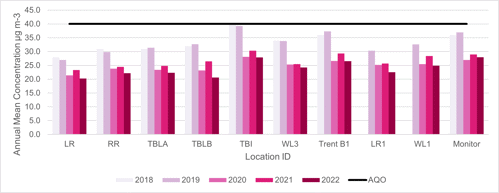
Trends in Annual Mean NO2 Concentrations Across All Locations (Continuous & Passive) in AQMA No 1/2011 Stragglethorpe Road between 2018 and 2022
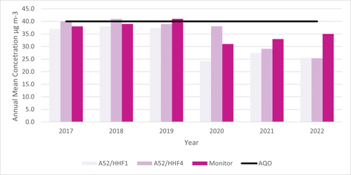
Trends in Annual Mean NO2 Concentrations Across All Diffusion Tube Locations not in an AQMA between 2018 and 2022
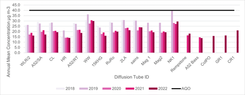
1-Hour Mean NO2 Monitoring Results, Number of 1-Hour Means > 200µg m-3
Site ID - Trent Bridge
X OS grid reference: 458256
Y OS grid reference: 338156
Site type: Roadside
Valid data capture for monitoring period (%): No data
Valid data capture 2022 (%): 99
- 2018: 0
- 2019: 0
- 2020: 0
- 2021: 0
- 2022: 0
Site ID - A52 Holme House
X OS grid reference: 463005
Y OS grid reference: 338208
Site type: Roadside
Valid data capture for monitoring period (%): No data
Valid data capture 2022 (%): 88.9
- 2018: 0
- 2019: 0
- 2020: 0
- 2021: 0
- 2022: 0
Notes:
Results are presented as the number of 1-hour periods where concentrations greater than 200µg m-3 have been recorded.
Exceedances of the NO2 1-hour mean objective (200µg m-3 not to be exceeded more than 18 times/year) are shown in bold.
If the period of valid data is less than 85%, the 99.8th percentile of 1-hour means is provided in brackets.
- Data capture for the monitoring period, in cases where monitoring was only carried out for part of the year.
- Data capture for the full calendar year (eg if monitoring was carried out for 6 months, the maximum data capture for the full calendar year is 50%).
Appendix B: Full Monthly Diffusion Tube Results for 2020
Diffusion Tube ID - WLR/2
X OS grid reference: 457873
Y OS grid reference: 337426
- January: 30.5
- February: 19.7
- March: 28.9
- April: 18.8
- May: 17.2
- June: 14.4
- July: 12.5
- August: 17.9
- September: 20.8
- October: 20.3
- November: 19.1
- December: 15.8
Annual Mean Raw Data: 19.6
Annual Mean - Annualised and Biased Adjusted: 16.3
Annual Mean - Distance Corrected to Nearest Exposure: Not applicable
Comment: None
Diffusion Tube ID - A52/SA
X OS grid reference: 465929
Y OS grid reference: 339543
- January: 31.1
- February: 18.8
- March: 26.6
- April: 20.6
- May: 15.3
- June: 17.5
- July: 13.7
- August: 23.7
- September: 25.0
- October: 20.2
- November: 23.6
- December: 14.3
Annual Mean Raw Data: 20.9
Annual Mean - Annualised and Biased Adjusted: 17.3
Annual Mean - Distance Corrected to Nearest Exposure: Not applicable
Comment: None
Diffusion Tube ID - CL
X OS grid reference: 457223
Y OS grid reference: 335033
- January: 39.6
- February: 29.0
- March: 21.5
- April: 18.7
- May: No data
- June: 20.5
- July: 16.3
- August: 16.6
- September: 23.8
- October: 23.5
- November: 30.5
- December: 17.8
Annual Mean Raw Data: 23.4
Annual Mean - Annualised and Biased Adjusted: 19.4
Annual Mean - Distance Corrected to Nearest Exposure: Not applicable
Comment: None
Diffusion Tube ID - HR
X OS grid reference: 458326
Y OS grid reference: 336714
- January:Not applicable
- February: 16.4
- March: 31.2
- April: 13.7
- May: No data
- June: 5.4
- July: 9.3
- August: 12.0
- September: 15.5
- October: 15.7
- November: 20.4
- December: 14.8
Annual Mean Raw Data: 16.9
Annual Mean - Annualised and Biased Adjusted: 14.0
Annual Mean - Distance Corrected to Nearest Exposure: Not applicable
Comment: None
Diffusion Tube ID - LR
X OS grid reference: 458126
Y OS grid reference: 337727
- January: 34.8
- February: 24.9
- March: 25.5
- April: 22.3
- May: 22.6
- June: 20.5
- July: 15.7
- August: 23.0
- September:28.0q
- October: 23.6
- November: 30.0
- December: 21.6
Annual Mean Raw Data: 24.4
Annual Mean - Annualised and Biased Adjusted: 20.2
Annual Mean - Distance Corrected to Nearest Exposure: Not applicable
Comment: None
Diffusion Tube ID - A52/RT
X OS grid reference: 464644
Y OS grid reference: 338730
- January: 32.6
- February: 21.8
- March: 25.5
- April: 22.7
- May: 20.5
- June: 20.0
- July: 14.3
- August: 24.2
- September: 27.3
- October: 20.9
- November: 24.5
- December: 16.4
Annual Mean Raw Data: 22.6
Annual Mean - Annualised and Biased Adjusted: 18.7
Annual Mean - Distance Corrected to Nearest Exposure: Not applicable
Comment: None
Diffusion Tube ID - RR
X OS grid reference: 458284
Y OS grid reference: 338150
- January: 37.0
- February: 24.8
- March: 32.7
- April: 26.4
- May: 25.7
- June: 22.5
- July: 18.3
- August: 29.0
- September: 30.2
- October: 24.8
- November: 30.3
- December: 18.8
Annual Mean Raw Data: 26.7
Annual Mean - Annualised and Biased Adjusted: 22.2
Annual Mean - Distance Corrected to Nearest Exposure: Not applicable
Comment: None
Diffusion Tube ID - TBLA
X OS grid reference: 458752
Y OS grid reference: 338278
- January: 40.3
- February: 29.0
- March: 31.5
- April: 23.4
- May: 27.4
- June: 25.0
- July: 17.7
- August: 23.6
- September: 28.2
- October: 26.8
- November: 31.7
- December: 17.8
Annual Mean Raw Data: 26.9
Annual Mean - Annualised and Biased Adjusted: 22.3
Annual Mean - Distance Corrected to Nearest Exposure: Not applicable
Comment: None
Diffusion Tube ID - TBLB
X OS grid reference: 458756
Y OS grid reference: 338267
- January: 37.9
- February: No data
- March: 31.0
- April: 24.2
- May: 24.6
- June: 21.5
- July: 15.0
- August: 25.3
- September: 27.6
- October: 23.7
- November: 26.3
- December: 16.3
Annual Mean Raw Data: 24.9
Annual Mean - Annualised and Biased Adjusted: 20.6
Annual Mean - Distance Corrected to Nearest Exposure: Not applicable
Comment: None
Diffusion Tube ID - TBI
X OS grid reference: 458274
Y OS grid reference: 338117
- January:41.5
- February: 35.5
- March: 40.6
- April: 28.9
- May: 29.5
- June: 31.8
- July: 25.8
- August: 34.3
- September:37.0
- October: 35.8
- November: 39.3
- December: 22.9
Annual Mean Raw Data: 33.6
Annual Mean - Annualised and Biased Adjusted: 27.9
Annual Mean - Distance Corrected to Nearest Exposure: Not applicable
Comment: None
Diffusion Tube ID - WL3
X OS grid reference: 458134
Y OS grid reference: 337581
- January: 46.9
- February: 31.4
- March: 28.5
- April: 23.6
- May: 26.0
- June: 25.3
- July: 15.7
- August: 26.2
- September: 31.8
- October: 28.9
- November: 36.9
- December: No data
Annual Mean Raw Data: 29.2
Annual Mean - Annualised and Biased Adjusted: 24.2
Annual Mean - Distance Corrected to Nearest Exposure: Not applicable
Comment: None
Diffusion Tube ID - WW
X OS grid reference: 457651
Y OS grid reference: 334840
- January: 47.2
- February: 36.1
- March: 42.4
- April: 33.1
- May: 32.3
- June: 35.0
- July: 24.4
- August: 35.1
- September: 40.1
- October: 37.1
- November: 45.3
- December: 25.3
Annual Mean Raw Data: 36.1
Annual Mean - Annualised and Biased Adjusted: 30.0
Annual Mean - Distance Corrected to Nearest Exposure: Not applicable
Comment: None
Diffusion Tube ID - A52/HHF1
X OS grid reference: 463011
Y OS grid reference: 338213
- January:40.3
- February: 32.0
- March: 29.6
- April: 29.6
- May: 33.0
- June: 30.5
- July: 21.4
- August: 32.5
- September: 34.6
- October: 30.2
- November: 35.8
- December: 18.8
Annual Mean Raw Data: 30.7
Annual Mean - Annualised and Biased Adjusted: 25.5
Annual Mean - Distance Corrected to Nearest Exposure: Not applicable
Comment: None
Diffusion Tube ID - A52/HHF4
X OS grid reference: 463040
Y OS grid reference: 338232
- January:36.4
- February: No data
- March: 39.1
- April: 30.0
- May: 28.9
- June: 29.5
- July: 20.7
- August: 32.4
- September: 35.2
- October: 30.7
- November: 33.4
- December: 20.4
Annual Mean Raw Data: 30.6
Annual Mean - Annualised and Biased Adjusted: 25.4
Annual Mean - Distance Corrected to Nearest Exposure: Not applicable
Comment: None
Diffusion Tube ID - 15 KHG
X OS grid reference: 470202
Y OS grid reference: 340092
- January:29.3
- February: 18.8
- March: 24.0
- April: 18.0
- May: 14.5
- June: 16.8
- July: 12.9
- August: 18.8
- September: 22.2
- October: 18.8
- November: 22.4
- December: 16.0
Annual Mean Raw Data: 19.4
Annual Mean - Annualised and Biased Adjusted: 16.1
Annual Mean - Distance Corrected to Nearest Exposure: Not applicable
Comment: None
Diffusion Tube ID - RuRo
X OS grid reference: 458132
Y OS grid reference: 336462
- January: 38.2
- February: 23.5
- March: 30.9
- April: 19.8
- May: 21.3
- June: 18.4
- July: 17.4
- August: 22.1
- September: 27.0
- October: 22.7
- November: 28.3
- December: 18.3
Annual Mean Raw Data: 24.0
Annual Mean - Annualised and Biased Adjusted: 19.9
Annual Mean - Distance Corrected to Nearest Exposure: Not applicable
Comment: None
Diffusion Tube ID - 2LA
X OS grid reference: 470248
Y OS grid reference: 339834
- January:34.2
- February: 27.7
- March: 26.9
- April: 21.7
- May: 24.8
- June: 25.9
- July: 15.9
- August: 23.0
- September: 25.4
- October: 30.4
- November: 33.9
- December: 18.3
Annual Mean Raw Data: 25.7
Annual Mean - Annualised and Biased Adjusted: 21.3
Annual Mean - Distance Corrected to Nearest Exposure: Not applicable
Comment: None
Diffusion Tube ID - Trent B1
X OS grid reference: 458249
Y OS grid reference: 338167
- January: 46.6
- February: 30.2
- March: 39.6
- April: 32.2
- May: 30.8
- June: 23.9
- July: 21.7
- August: 38.0
- September: 37.9
- October: 26.7
- November: 35.3
- December: 21.4
Annual Mean Raw Data: 32.0
Annual Mean - Annualised and Biased Adjusted: 26.6
Annual Mean - Distance Corrected to Nearest Exposure: Not applicable
Comment: None
Diffusion Tube ID - Mag 1
X OS grid reference: 459366
Y OS grid reference: 334244
- January: 37.1
- February: 24.3
- March: 25.8
- April: 19.8
- May: 20.8
- June: 21.7
- July: 13.9
- August: 20.3
- September: 24.1
- October: 25.6
- November: 29.4
- December: 17.7
Annual Mean Raw Data: 23.4
Annual Mean - Annualised and Biased Adjusted: 19.4
Annual Mean - Distance Corrected to Nearest Exposure: Not applicable
Comment: None
Diffusion Tube ID - Mag 2
X OS grid reference: 459324
Y OS grid reference: 334227
- January: 34.2
- February: 21.5
- March: 28.3
- April: 19.8
- May: 23.3
- June: 20.9
- July: 14.3
- August: 18.9
- September: 25.3
- October: 25.6
- November: 31.7
- December: 16.4
Annual Mean Raw Data: 23.3
Annual Mean - Annualised and Biased Adjusted: 19.4
Annual Mean - Distance Corrected to Nearest Exposure: Not applicable
Comment: None
Diffusion Tube ID - LR 1
X OS grid reference: 458100
Y OS grid reference: 337543
- January:41.8
- February: 26.5
- March: 32.0
- April: 28.4
- May: 20.2
- June: 21.8
- July: 16.9
- August: 28.9
- September: 32.2
- October: 27.8
- November: 31.7
- December: 18.0
Annual Mean Raw Data: x
Annual Mean - Annualised and Biased Adjusted: x
Annual Mean - Distance Corrected to Nearest Exposure: Not applicable
Comment: None
Diffusion Tube ID - WL 1
X OS grid reference: 458055
Y OS grid reference: 337566
- January: 40.3
- February: 32.4
- March: 34.4
- April: 25.7
- May: 30.6
- June: 26.5
- July: 16.9
- August: 28.7
- September: 33.6
- October: 33.7
- November: 37.0
- December: 20.4
Annual Mean Raw Data: 30.0
Annual Mean - Annualised and Biased Adjusted: 24.9
Annual Mean - Distance Corrected to Nearest Exposure: Not applicable
Comment: None
Diffusion Tube ID - NK 1
X OS grid reference: 457612
Y OS grid reference: 334859
- January: 43.3
- February: 32.2
- March: 39.7
- April: 27.9
- May: 34.6
- June: 31.9
- July: 19.7
- August: 30.6
- September: 36.3
- October: 38.9
- November: 47.3
- December: 43.7
Annual Mean Raw Data: 35.5
Annual Mean - Annualised and Biased Adjusted: 29.5
Annual Mean - Distance Corrected to Nearest Exposure: Not applicable
Comment: None
Diffusion Tube ID - Sains
X OS grid reference: 457303
Y OS grid reference: 333214
- January: 35.2
- February: 23.1
- March: 39.5
- April: 27.8
- May: No data
- June: 21.6
- July: 20.8
- August: 27.3
- September: 30.5
- October: 25.8
- November: 32.7
- December: 34.0
Annual Mean Raw Data: 28.9
Annual Mean - Annualised and Biased Adjusted: 24.0
Annual Mean - Distance Corrected to Nearest Exposure: Not applicable
Comment: None
Diffusion Tube ID - Rempston
X OS grid reference: 457621
Y OS grid reference: 324386
- January: 30.6
- February: 18.9
- March: 23.6
- April: 20.0
- May: 19.7
- June: 19.1
- July: 16.3
- August: 21.3
- September: 21.9
- October: 19.2
- November: 25.9
- December: 25.5
Annual Mean Raw Data: 21.8
Annual Mean - Annualised and Biased Adjusted: 18.1
Annual Mean - Distance Corrected to Nearest Exposure: Not applicable
Comment: None
Diffusion Tube ID - A52 Bass
X OS grid reference: 461816
Y OS grid reference: 337855
- January:23.4
- February: 14.3
- March: 21.6
- April: No data
- May: No data
- June: 10.3
- July: 10.6
- August: 16.3
- September: 18.6
- October: 13.0
- November: 16.0
- December: 22.4
Annual Mean Raw Data: 16.7
Annual Mean - Annualised and Biased Adjusted: 13.8
Annual Mean - Distance Corrected to Nearest Exposure: Not applicable
Comment: None
Diffusion Tube ID - CotPO
X OS grid reference: 464495
Y OS grid reference: 335387
- January: Not applicable
- February: 17.6
- March: 28.2
- April: 20.4
- May: 16.6
- June: 12.5
- July: 12.4
- August: 17.8
- September:21.4
- October: 16.8
- November: 21.3
- December: 25.8
Annual Mean Raw Data: 19.1
Annual Mean - Annualised and Biased Adjusted: 15.9
Annual Mean - Distance Corrected to Nearest Exposure: Not applicable
Comment: None
Diffusion Tube ID - GR1
X OS grid reference: 458897
Y OS grid reference: 337350
- January: Not applicable
- February: 20.8
- March: 24.2
- April: 16.9
- May: 15.6
- June: 14.6
- July: 12.4
- August: 15.6
- September: 20.5
- October: No data
- November: No data
- December: No data
Annual Mean Raw Data: 17.6
Annual Mean - Annualised and Biased Adjusted: 16.3
Annual Mean - Distance Corrected to Nearest Exposure: Not applicable
Comment: None
Diffusion Tube ID - CR1
X OS grid reference: 457262
Y OS grid reference: 333336
- January: No data
- February: 27.0
- March: 30.5
- April: 20.7
- May: No data
- June: 21.2
- July: 17.5
- August: 22.4
- September: 26.7
- October: 24.6
- November: 31.7
- December: 32.0
Annual Mean Raw Data: 25.4
Annual Mean - Annualised and Biased Adjusted: 21.1
Annual Mean - Distance Corrected to Nearest Exposure: Not applicable
Comment: None
Trends in Annual Mean NO2 Concentrations Across All Diffusion Tube Locations between 2018 and 2022
This bar chart shows the trends over time plotted using the data from the locations above.
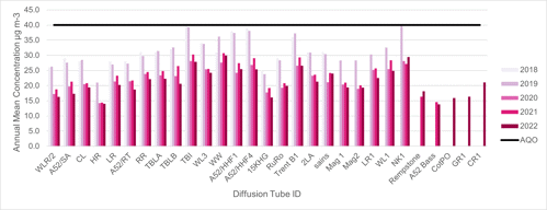
Appendix C: Supporting Technical Information / Air Quality Monitoring Data QA/QC
New or Changed Sources Identified Within Rushcliffe Borough Council During 2022
Rushcliffe Borough Council has not identified any new sources relating to air quality within the reporting year of 2022.
Additional Air Quality Works Undertaken by Rushcliffe Borough Council During 2022
Rushcliffe Borough Council has not completed any additional works within the reporting year of 2022.
QA/QC of Diffusion Tube Monitoring
All monitoring and data management is undertaken by fully trained in-house employees who have several years’ experience in air quality monitoring and data management. Any new personnel undertake appropriate supervised training in line with the Service’s competency scheme prior to any unsupervised monitoring, calibration or data management. Currently two personnel are trained and competent to undertake such work.
The location of the diffusion tube monitoring sites is reviewed periodically (at least annually). Locations may be removed where for example data indicates annual mean concentrations are consistently well below the Air Quality Objective; and new locations may be added where potential new sources have been identified or concerns have been raised by the public.
Nitrogen Dioxide Diffusion Tube Monitoring
Rushcliffe Borough Council use Gradko diffusion tubes prepared using 20% Triethanolamine (TEA) in water to measure nitrogen dioxide at a number of sites across the Borough. The diffusion tubes are stored in an airtight bag in a refrigerator upon receipt in the post and are used within 6 weeks of the preparation date displayed on the label.
Tube batches are exposed at selected sites to the atmosphere for approximately 4 weeks with the changeover date aiming to be +/-one day of the published diffusion tube change over date for the month to allow comparison with other Local Authority studies if necessary. All tubes are mounted using spacer brackets and grommets supplied by Gradko.
Each tube is labelled with a bar code and unique identification number. Each batch is supplied with a data collection form to record the location, date and time each tube is exposed in that period. The exposure period is calculated using an Excel spreadsheet and in addition Gradko recheck the calculated exposure period for each tube on receipt at the laboratory.
On the day of collection, the tubes are sent in an airtight bag to Gradko International Limited for analysis, together with a control blank that is stored unexposed in the sample fridge. The diffusion tubes are analysed within the scope of Gradko International Limited Laboratory Quality Procedures utilising in-house Laboratory Method GLM7. Gradko is a UKAS accredited laboratory and undertakes diffusion tube monitoring and analyses on the same basis for a number of other local authorities and environmental consultants. All local authorities in the Nottinghamshire Pollution Working Group use Gradko for their diffusion tube monitoring and analyses.
Nitrogen dioxide absorbed as nitrite by TEA is determined by spectrophotometric measurement at 540 nanometres. Nitrite reacts with the added reagent to form a reddish-purple azo dye and the optical density of this complex is measured using Camspec UV/Visible Spectrophotometer. The concentrations of nitrogen dioxide are then calculated from a pre-calibrated response factor and exposure times. The values are blank corrected using the blank ‘control’ diffusion tube provided by Rushcliffe Borough Council.
The accuracy of the measurements made by Gradko are monitored by participation in an external laboratory measurement proficiency scheme, the Workplace Analysis Scheme for Proficiency (WASP), implemented by the Health and Safety Laboratory in Sheffield. The results of the most recent WASP analysis are available LAQM - Diffusion Tube QA/QC Framework.
All diffusion tube data is checked on a monthly basis to identify any spurious data and compared with other local monitoring sites to further identify any suspect data.
The 2022 monitoring was completed in accordance with the 2022 Diffusion Tube Monitoring Calendar.
Annualisation is required for any site with data capture less than 75% but greater than 25%. Therefore, based on this criteria annualisation was required for one diffusion tube location – GR1 which had 8 months of data (66.7% data capture) for 2022. Annualisation was undertaken using the Diffusion Tube Data Processing Tool. The nearest continuous background sites were Nottingham Centre (Defra UK-AIR ID: UKA00274), Leicester University (Defra UK-AIR ID: UKA00573) and Derby St Alkmund’s Way (Defra UK-AIR ID: UKA00630) each of which had data capture greater than 85% for 2022. In previous years we have used data from the Burton-on-Trent Horninglow site (Defra UK-AIR ID: UKA00652) for annualisation purposes. However, as the data capture at this location was less than the required 85% in 2022 it could not be used and Derby St Alkmund’s Way (Defra UK-AIR ID: UKA00630) was used instead. The annualisation tool calculated an average annualisation factor of 1.12 for location GR1 which was used to adjust the raw data simple annual mean at this location.
Annualisation Summary (concentrations presented in µg/m3)
| Site ID | Annualisation on Factor Nottingham Centre | Annualisation on Factor Leicester University | Annualisation on Factor Derby St Alkmund's Way | Annualisation on Factor <Site 4 Name> | Average Annualisation on Factor | Raw Data Annual Mean | Annualised Annual Mean |
|---|---|---|---|---|---|---|---|
| GR1 | 1.10 | 1.13 | 1.12 | no data | 1.12 | 17.6 | 19.7 |
Diffusion Tube Bias Adjustment Factors
The diffusion tube data presented within the 2023 ASR have been corrected for bias using an adjustment factor. Bias represents the overall tendency of the diffusion tubes to under or over-read relative to the reference chemiluminescence analyser. LAQM.TG22 provides guidance with regard to the application of a bias adjustment factor to correct diffusion tube monitoring. Triplicate co-location studies can be used to determine a local bias factor based on the comparison of diffusion tube results with data taken from NOx/NO2 continuous analysers. Alternatively, the national database of diffusion tube co-location surveys provides bias factors for the relevant laboratory and preparation method.
Rushcliffe Borough Council have applied a national bias adjustment factor of 0.83 to the 2022 monitoring data. This was derived from the national database of bias factors (Database_Diffusion_Tube_Bias_Factors_v03_23-FINAL) for Gradko tubes, 20% TEA in water and based on 27 studies. A summary of bias adjustment factors used by Rushcliffe Borough Council over the past five years is presented in Table C.2. Rushcliffe Borough Council does not currently have any co-location sites and therefore a local factor could not be calculated.
| Year | Local or National |
If National, Version of National Spreadsheet |
Adjustment Factor |
|---|---|---|---|
| 2022 | National | 03/23 | 0.83 |
| 2021 | National | 03/22 | 0.84 |
| 2020 | National | 03/21 v2 | 0.81 |
| 2019 | National | 03/20 | 0.93 |
| 2018 | National | 03/19 | 0.93 |
NO2 Fall-off with Distance from the Road
Wherever possible, local authorities should ensure that monitoring locations are representative of exposure. However, where this is not possible, the NO2 concentration at the nearest location relevant for exposure should be estimated using the Diffusion Tube Data Processing Tool/NO2 fall-off with distance calculator available on the LAQM Support website. Where appropriate, non-automatic annual mean NO2 concentrations corrected for distance are presented in Table B.1.
No diffusion tube NO2 monitoring locations within Rushcliffe Borough Council required distance correction during 2022.
QA/QC of Automatic Monitoring
The NO2 continuous monitor within AQMA No 1 Trent Bridge is located at the junction of Radcliffe Road and Loughborough Road, West Bridgford and is a permanent site. It was installed at this location in 2017 and is a ML9841B single chamber chemiluminescence analyser and is approved by TUV, USEPA and NETCEN. Within AQMA No 1/2011 Stragglethorpe Road a chemiluminescence analyser was installed adjacent to the dwelling façade in a Kaizen enclosure in early 2014.
The analysers have a resolution of 0.001ppm and a reported lower detection limit of <0.5ppb. The linearity error of the analyser is +/-1% of the full scale (from best line fit), and the precision is 0.5ppb or 1% of concentration reading (whichever is greater).
Instrument Checks and Calibration
Daily automated calibration: Zero air is generated by passing air through the scrubbers and the reaction cell. Span gas is generated by a permeation tube and passed to the reaction chamber to give the span calibration response. The daily automatic calibrations are used to check the instrument performance and drift.
Analyser Inspection and Manual Calibration: The analysers are covered by an annual service and maintenance contract to include calibration checks, flow and leak checks, cleaning of components, analyser diagnostic checks, replacement of faulty components and consumables and fault call-out.
Manual calibration checks are carried out by Rushcliffe Borough Council staff on a fortnightly basis using scrubbed zero air derived from the integrated scrubber column and a certified NO/NOX calibration gas is supplied by BOC gases. The BOC gas is changed when the certification expires. The analyser is taken out of service and the inlet filter changed prior to connecting the calibration gases. The zero air and NO/NOX gases are run through the analyser and the response times noted together with the instrument gain factor. The output of the analyser (e.g. the gain) is only reset or altered following equipment service or repair or if drift occurs necessitating a change of the gain setting. The calibration zero values, span values and gas certified values are used to rescale the raw data received from the analyser.
Validation: all data are continuously screened algorithmically and manually for anomalies. There are several techniques designed to discover spurious and unusual measurements within large datasets. These anomalies may be due to equipment failure, power failure, human error, interference or other disturbances. Automatic screening can only safely identify spurious results that need further manual investigation.
Raw data from the gaseous instruments are scaled into concentrations using the latest values derived from the automatic and manual calibrations. These instruments are not absolute and suffer drifts. Both the zero baseline and the sensitivity may change over time. Regular calibrations with certified gas standards are used to measure the zero and sensitivity. However, these are only valid for the moment of the calibration since the instrument will continue to drift.
Data Ratification
All raw data is examined for consistency and the existence of any spurious results. Negative values are examined and either removed or rescaled further and high values interrogated to see if the readings are consistent with expectations or an equipment error may have occurred. Data obtained during calibration checks is automatically excluded from the database by a software service switch on the instrument panel which is used during calibration checks.
If any doubts exist as to the satisfactory status of any data it is excluded from the database calculations. The reason for exclusion of a dataset is annotated against it to allow for traceability and data ratification. The most common reason for exclusion is monitor breakdown leading to consistently high or low readings. However, a power failure can also be a cause as can specific events noted by Officers during visits e.g. trucks/equipment in operation next to the monitor for building façade maintenance or similar.
Information from other analysers on the system can also be accessed to compare any data that may be experiencing high or low readings to enable a decision to be made on the status of any highlighted data. This includes the Automatic Urban and Rural Network (AURN) monitors operated by Nottingham City Council.
Air Quality Data Management (AQDM) prepare a monthly monitoring report of provisional measurements for the Rushcliffe and Nottingham network and every quarter the available information is critically assessed so that the best data scaling is applied, and all anomalies are appropriately edited. Although this quarterly data processing helps build a reliable dataset as unexpected faults can be identified during the routine servicing or independent audits the data can only be fully ratified in 12 month or annual periods. Data ratification is undertaken by AQDM to LAQM (TG16) standards using the AURN methodology and reported for each of the two continuous monitors. The data presented in this ASR has been ratified.
Historic and live data for Rushcliffe Borough Council is available to view via the UK AIR website.
Automatic Monitoring Annualisation
All automatic monitoring locations within Rushcliffe Borough Council recorded data capture of greater than 75% therefore it was not required to annualise any monitoring data. In addition, any sites with a data capture below 25% do not require annualisation.
The NO2 annual data capture for the continuous monitor located in AQMA No 1 Trent Bridge was 99% and 88.9% for the continuous monitor located in AQMA No1/2011 Stragglethorpe Road.
NO2 Fall-off with Distance from the Road
Wherever possible, monitoring locations are representative of exposure. However, where this is not possible, the NO2 concentration at the nearest location relevant for exposure has been estimated using the NO2 fall-off with distance calculator available on the LAQM Support website. Where appropriate, non-automatic annual mean NO2 concentrations corrected for distance are presented in Table B.1.
No automatic NO2 monitoring locations within Rushcliffe Borough Council required distance correction during 2022.
Appendix D: Maps of Monitoring Locations and AQMAs
Please note, maps can be found on the pdf version of the Air Quality Annual Status 2023 report. The report shows the following maps:
D.1 – Map Showing the Borough wide diffusion tube network
D.2 – Map Showing the diffusion tube network across West Bridgford
D.3 – Map Showing Location of AQMA No 1 Trent Bridge and continuous monitor and diffusion tube locations
D.4 – Map of AQMA No 1/2011 Stragglethorpe Road showing continuous monitor and diffusion tube locations
Appendix E: Summary of Air Quality Objectives in England
| Pollutant | Air Quality Objective: Concentration (units in micrograms of pollutant per cubic metre of air) | Air Quality Objective: Measured as |
|---|---|---|
| Nitrogen Dioxide (NO2) | 200µg/m3 not to be exceeded more than 18 times a year | 1 hour mean |
| Nitrogen Dioxide (NO2) | 40µg/m3 | Annual mean |
| Particulate Matter (PM10) | 50µg/m3, not to be exceeded more than 35 times a year | 24 hour mean |
| Particulate Matter (PM10) | 40µg/m3 | Annual mean |
| Sulphur Dioxide (SO2) | 350µg/m3, not to be exceeded more than 24 times a year | 1 hour mean |
| Sulphur Dioxide (SO2) | 125µg/m3, not to be exceeded more than 3 times a year | 24 hour mean |
| Sulphur Dioxide (SO2) | 266µg/m3, not to be exceeded more than 35 times a year | 15 minute mean |
Glossary of Terms
| Abbreviation | Description |
|---|---|
| AQAP | Air Quality Action Plan - A detailed description of measures, outcomes, achievement dates and implementation methods, showing how the local authority intends to achieve air quality limit values’ |
| AQMA | Air Quality Management Area – An area where air pollutant concentrations exceed / are likely to exceed the relevant air quality objectives. AQMAs are declared for specific pollutants and objectives |
| ASR | Annual Status Report |
| ATP | Active Travel Fund |
| AURN | Automatic Urban and Rural Network (Defra) - UK's largest automatic monitoring network and is the main network used for compliance reporting against the Ambient Air Quality Directives. It includes automatic air quality monitoring stations measuring oxides of nitrogen (NOx), sulphur dioxide (SO2), ozone (O3), carbon monoxide (CO) and particles (PM10, PM2.5) |
| BSIP | Bus Service Implementation Plans |
| D2N2 | Local Enterprise Network area covering Derby, Derbyshire, Nottingham and Nottinghamshire |
| (D2N2) LEAP | D2N2 Local Energy Area Plan |
| Defra | Department for Environment, Food and Rural Affairs |
| DfT | Department for Transport |
| DMRB | Design Manual for Roads and Bridges – Air quality screening tool produced by National Highways |
| EMAQN | East Midlands Air Quality Network |
| EU | European Union |
| FDMS | Filter Dynamics Measurement System |
| HVO | Hydrogenated Vegetable Oil |
| LAQM | Local Air Quality Management |
| LEVI | Local Electric Vehicle Infrastructure (OZEV) - Fund supports local authorities in England to plan and deliver chargepoint infrastructure for residents without off-street parking |
| LPG | Liquified Petroleum Gas |
| LTP | Local Transport Plan |
| NCC | Nottinghamshire County Council |
| NCiC | Nottingham City Council |
| NEPWG | Nottinghamshire Environmental Protection Working Group |
| NH | National Highways |
| NO2 | Nitrogen Dioxide |
| NOX | Nitrogen Oxides |
| OHID | Office for Health Improvement and Disparities |
| OZEV | Office for Zero Emission Vehicles |
| PHE | Public Health England (now replaced with Office for Health Improvement and Disparities (OHID) and UK Health Security Agency (UKHSA)) |
| PHOF | Public Health Outcomes Framework |
| PM10 | Airborne particulate matter with an aerodynamic diameter of 10µm or less |
| PM2.5 | Airborne particulate matter with an aerodynamic diameter of 2.5µm or less |
| QA/QC | Quality Assurance and Quality Control |
| RBC | Rushcliffe Borough Council |
| SO2 | Sulphur Dioxide |
| UKHSA | United Kingdom Health Security Agency (formerly known as Public Health England) |
| ULEV | Ultra Low Emissions Vehicles |
| ZEBRA | Zero Emission Bus Regional Areas |
References
- Local Air Quality Management Technical Guidance LAQM.TG22. August 2022. Published by Defra in partnership with the Scottish Government, Welsh Assembly Government and Department of the Environment Northern Ireland.
- Local Air Quality Management Policy Guidance LAQM.PG22. August 2022. Published by Defra in partnership with the Scottish Government, Welsh Assembly Government and Department of the Environment Northern Ireland.
- Copeland B (2021) A comparison of gas and electric cremator emissions in the UK. A dissertation submitted to the School of Energy, Construction and Environment, Faculty of Engineering, Environment and Computing, Coventry University in partial fulfilment of the requirements for the degree of Geography BSc (Hons)
Accessible Documents
- Air Quality Action Plan 2021
- Air Quality Annual Status Report 2023
- Air Quality Annual Status Report 2022
- Air Quality Annual Status Report 2021
- Air Quality Strategy for Nottingham and Notts
- Auditor's Annual Report 2021
- Internal Audit Annual Report 2021/22
- Auditor's Annual Report 2021-22
- Annual Governance Statement 2021-22
- Annual Governance Statement 2020-21
- Asset Management Strategy
- Become a Councillor 2022
- Budget and Financial Strategy 2021-22
- Budget and Financial Strategy 2022-23
- Budget and Financial Strategy 2023-24
- Budget and Financial Strategy 2024-25
- Capital and Investment Strategy
- Climate Change Strategy 2021-2030
- Compulsory Purchase Order Procedure Protocol
- Confidential Reporting Code
- Corporate Enforcement Policy
- Corporate Strategy 2024-2027
- Council Constitution
- Council Tax Recovery and Enforcement Policy 2023
- Customer Access Strategy
- Discretionary Housing Payments Policy 2023-2024
- Disabled Facilities Grant Policy 2022
- Equalities Scheme 2021-25
- Empty Homes Strategy
- Environment Policy 2023
- External and Internal Communications Strategy
- Freedom Of Information Policy
- HB Recovery and Enforcement Policy
- Homelessness and Rough Sleeping Strategy
- Housing Allocations Policy
- ICT Strategy 2022 -25
- Information Management and Governance Strategy 2022-25
- Rushcliffe Borough Council Information Retention Schedule
- Leisure Strategy 2021-2027 review
- Local Code of Corporate Governance 2021/22
- Local Plan Part 1: Core Strategy
- Local Plan Part 2: Land and Planning Policies
- Local Scheme of Validation
- Off-street Car Parking Strategy
- Pay Policy Statement
- People Strategy 2021-26
- Planning Enforcement Policy
- Procurement Strategy
- Playing Pitch Strategy 2022
- 2021-22 Public Inspection Notice
- RIPA Policy and Guidance
- Risk Management Strategy 2023-26
- Rushcliffe Nature Conservation Strategy
- Statement of Gambling Licensing Principles
- Statement of Accounts 2019-20
- Statement of Accounts 2020-21
- Statement of Accounts 2021-22
- Statement of Accounts 2021-22 (unaudited)
- Statement of Accounts 2022-23 (unaudited)
- Statement of Accounts 2022-23 (audited)
- Statement of Licensing Policy
- Tenancy Strategy 2019
- Transformation Strategy and Efficiency Plan
- Tree Management and Protection Policy 2023
- WISE Agreement
- Neighbourhood Plans
- Conservation Areas
- Supplementary Planning Documents
- Local Plan Monitoring Report