Hickling Conservation Area
Hickling Conservation Area Appraisal and Management Plan July 2023

Contents
1.1 Conservation Areas
1.2 The Purpose of a Conservation Area Character Appraisal
1.3 The Planning Policy Context
2 Hickling Location and Landscape Setting
2.1 Topography and Geography
2.2 The Hickling Conservation Area
3.1 Location and Historic Activities
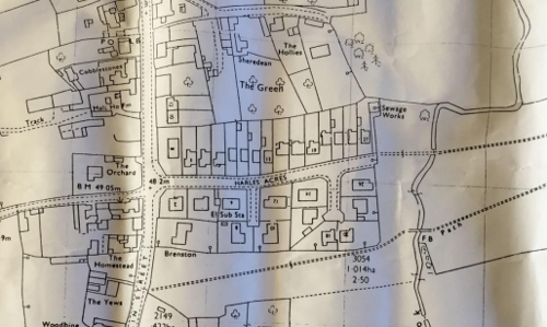
3.2 Historical Mapping
4.1 Plan, Form and Layout
4.2 Landmarks, Focal Points and Views
4.3 Open Spaces, Trees and Landscape
4.3.1 Open Spaces, Trees and Landscape SWOT Analysis
4.4 Public Realm
5 Buildings of the Conservation Area and Key Characteristics
5.1 Building Types and Activity
5.1.1 Building types and Activity SWOT Analysis
5.2 Key Characteristics and Building Materials
5.2.1 Key Characteristics: Zone 1 - St Luke's Church and Associated Land
5.2.2 Key Characteristics: Character Zone 2 - The Grantham Canal, Hickling Canal Basin, Wharf Building and Wharf Yard, The Plough Inn and Bridge View)
5.2.3 Key Characteristics: Character Zone 3- Main Street (and the roads and lanes which join from the east and west)
5.2.4 Key Characteristics: Zone 4 - Harles Acre - 20th century development
5.2.5 Hickling Conservation Area: Zone Map
5.3 Listed buildings
5.4 Key Unlisted Buildings
5.5 Contemporary examples of sensitive development and / or restoration
5.6 Buildings at Risk
6.1 Introduction
6.2 National and Local Policies and Guidance
6.3 Article 4 Directions
6.4 Building Design
6.4.1 Re-use and adaptation of old buildings
6.4.2 Contemporary Design
6.4.3 Microgeneration Technologies
6.5 Publicity and Knowledge Transfer
6.6 Public Realm
6.6.1 Tranquillity
6.6.2 Local Green Spaces
6.7 Boundary Treatments
6.7.1 Walls and Fences
6.7.2 Hedges
6.8 Buildings at risk
6.9 Enforcement
7 Appendix 1 – Listed Buildings (as of February 2023)
8 Appendix 2 – Conservation Area Boundary and Townscape Appraisal Map
1 Introduction
1.1 Conservation Areas
Rushcliffe Borough Council has an obligation under Section 69 of the Planning (Listed Buildings and Conservation Areas) Act 1990 to review, from time to time, its Conservation Area designations.
A Conservation Area, as defined under Section 69, is ‘an area of special architectural or historic interest the character or appearance of which it is desirable to preserve or enhance’.
Hickling Conservation Area was first designated in 1990. There was then a review of the Hickling Conservation Area appraisal in 2008 when the boundaries were changed to include a listed building and gardens and paddocks associated with many of the older buildings.
Section 71 of the Planning (Listed Buildings and Conservation Areas) Act 1990 highlights the local planning authority’s duty to formulate and publish proposals for the preservation and enhancement of the Conservation Areas. This document, therefore, aims to identify and reaffirm (or redefine) the special architectural or historic interest of the area which warrants its designation.
Conservation Area Appraisals are not, and never have been, tools to fossilise a place against change, instead, the processes of change which allow places to grow and evolve are recognised as being unavoidable, and it is also recognised that change can be a positive and desirable force. The designation instead allows greater scrutiny and control to manage change to positive effect and to ensure that any changes which require planning permission do not harm, and ideally serve to actively enhance, the existing character of the place
Hickling Conservation Area: Summary of Special Interest
Characteristic 1
Hickling is located in the south east of the Borough, close to the Leicestershire border in the Vale of Belvoir.
Characteristic 2
The perceptibility of the historic foundations of the village provides a firm basis for its character
Characteristic 3
The linear form of Hickling village creates the special character of the Conservation Area.
Characteristic 4
Paddocks and fields flow into the street scene providing vital visual open and green spaces and reinforcing the rural location of the village.
Characteristic 5
The cottages, farmhouses, outbuildings, and hedgerows that line Main Street form a distinctive collective group.
Characteristic 6
The working farms add life and personality.
Characteristic 7
The canal and canal basin form important tranquil recreational spaces and areas of great biodiversity value.
1.2 The Purpose of a Conservation Area Character Appraisal
The purpose of a Conservation Area Character Appraisal is to:
- Identify and record the special interest of the Conservation Area to ensure there is public awareness and understanding of what is worthy of preservation.
- To define and reassess current boundaries to accurately reflect what is now perceived to be of special interest.
- To identify opportunities to safeguard and enhance the special interest of the Conservation Area.
It should be noted that the content in this document is not a comprehensive account of every significant building, structure, tree, wall, feature, or space. Therefore, any omission should not be assumed to imply that they are of no interest.
Generally, the character and appearance of a Conservation Area will be preserved or enhanced by:
- Providing controls and regulating development through the planning system.
- Applying the extra controls that designation provides over demolition, minor development, and the protection of trees.
- Environmental enhancement schemes and possibly providing financial assistance for the repair and restoration of specific buildings.
- Encouraging public bodies such as the local highways authority or utility companies to take opportunities to improve the street scene through the appropriate design and sensitive sighting of street furniture (and retention of historic features of interest), or the removal of eyesores and street features that have a negative impact such as overhead wires.
1.3 The Planning Policy Context
This appraisal provides a firm basis on which applications for development within the Hickling Conservation Area would be assessed. It should be read alongside the wider development plan policy framework produced by Rushcliffe Borough Council and other National Planning Policy Guidance documents. The relevant documents include:
- Hickling Neighbourhood Parish Plan 2011-2028 (adopted 2022)
- Rushcliffe Local Plan Part 1: Core Strategy, with a specific focus on:
- Policy 10 (Design and Enhancing Local Identity) [in part]
- Policy 11 (Historic Environment)
- Rushcliffe Local Plan Part 2: Development Policies, with a specific focus on:
- Policy 28 (Conserving and Enhancing Heritage Assets)
- Policy 29 (Development Affecting Archaeological Sites)
- The National Planning Policy Framework (NPPF) (Revised -2024)
- The National Planning Practice Guidance (2015 - Subject to Continual Review)
- By Design: Urban Design in the Planning System – Towards Better Practice (2000)
- The Planning (Listed Buildings and Conservation Areas) Act 1990
Hickling Conservation Area: Summary of Key Issues
Key Issue 1
Alterations to Listed and key unlisted properties – a number of the unlisted, and some of the Listed buildings in the Conservation Area have been adversely affected by the loss of architectural details, building materials and positive features.
Key Issue 2
Boundary treatments – boundaries, such as walls or hedges, are as important in determining the character of any Conservation Area as the buildings behind them. The loss of predominant types of boundary (Rural, Mixed) has the potential to cause harm to the character of the Hickling Conservation Area.
Key Issue 3
Agriculture – overall, Hickling’s agricultural heritage contributes positively to its character, but it is important that any negative impacts are minimised.
Key Issue 4
The Grantham Canal - the canal and canal basin are extremely important to Hickling’s character and to the health and wellbeing of residents. The loss of tranquillity and positive open and green space would significantly affect the character of the area.
Key Issue 5
Development Pressures – Hickling’s linear form, green spaces and views out to open countryside are vital in creating the special rural character of the village.
Key Issue 6
Highways and Transportation - Speeding vehicles and HGVs passing through the village are both dangerous and detrimental to the character of the Conservation Area.
Key Issue 7
Public Realm – Grass verges, street surfaces and furniture along with public rights of way play a major role in shaping the rural (non-urban) character of the Conservation Area. The Hickling Neighbourhood Plan Design Guide should be referred to.
Key Issue 8
Buildings and locations at risk – Several buildings are potentially ‘at risk’ of neglect or decay and routine maintenance work may be required. Concerns include; over-development, over-intensive development and insensitive renovation.
2 Hickling Location and Landscape Setting
Rushcliffe Borough forms the southern tip of Nottinghamshire, which borders Leicestershire. It is predominantly a rural Borough that contains a mixture of city suburbs, market towns and villages. Rushcliffe is located about half a mile South of Nottingham city centre, with the River Trent forming the majority of its northern boundary and the River Soar defining its western boundary.
The A46, a distinctive Roman Road, runs through the centre of the Borough and leads to Newark in the North and Leicester in the South. In the northern half of the Borough, the A52 forms Nottingham’s primary transport link to Grantham and the East of England. Junction 24 of the M1 and East Midlands Airport are located about 1 mile from the western border.

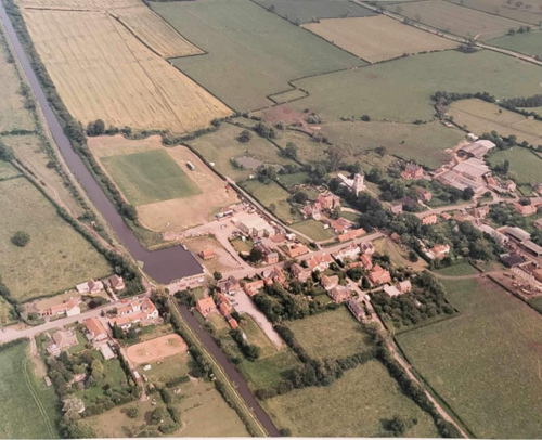
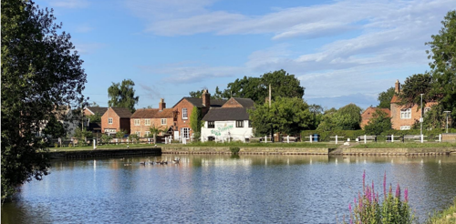
Hickling is located in the South East of the Borough, close to the Leicestershire border and is surrounded by open countryside. Hickling is a working village and has always had a strong farming community. Both arable and dairy farming are still an important part of village life. The Grantham Canal passes through the village close to the pub; the canal with canal basin and wharf building create a key focal point and are of great recreational and biodiversity value. In addition, the community is served by two traditional, positive amenities; The Plough Inn and an active Village Hall, as well as a thriving tearooms business adjacent to the canal basin.
2.1 Topography and Geography
Hickling is located on relatively low ground (45 metres above sea level) at the foot of the Hickling Standard (105m/trig point) and a number of other high points of 50m. The village is located in an area known as the Vale of Belvoir, characterised by clay soils with slowly or moderately permeable topsoils that have developed in the Lias deposits of the Vale. The Hickling area is particularly rich with unimproved permanent pasture, species-rich hedgerows and ridge and furrow. (Nottinghamshire County Council, 1997).
2.2 The Hickling Conservation Area
- Conservation Area Boundary covers: 43.6 hectares (approximately)
- Number of Grade 1 listed buildings: 1
- Number of Grade 2* listed buildings: 0
- Number of Grade 2 listed buildings: 24
A full list of Hickling Conservation Area’s Listed buildings can be found in Appendix 1. Details accurate as of February 2023.
3 Historical Contexts
3.1 Location and Historic Activities
The landscape of the Vale of Belvoir is superficially a creation of the enclosure movement of the 16th, 17th and 18th centuries, modified by the requirements of the post-1945 economy and, more recently, modern farming techniques. Behind this, however, stands over 3,000 years of settlement and land use which, through the generations, have influenced the development of the early 21st century countryside. From late prehistory to the end of the 18th Century, this region was consistently part of the most densely settled and economically strong area of pre-industrial Nottinghamshire.
There is evidence of early prehistoric activity (flint tools), and during late prehistory, the Vale of Belvoir became extensively settled. When the Romans arrived in the middle of the 1st Century AD, they found an already well-settled and developed landscape. It appears that the Vale of Belvoir was an agricultural hinterland to the Roman towns of Margidunum, near Bingham, and Vernemetum, near Willoughby on the Wolds, and to settlements in Leicestershire. The result of this history was the clearance of the natural woodland and the development of an agricultural landscape of arable and pasture fields. The landscape was likely to have remained in a similar state up until the 8th or 9th centuries.
The Scandinavian invasions in the 9th and 10th centuries brought changes to the landscape, with the dispersed settlement pattern being replaced by nucleated villages with people grouping together around the farm of the local lord, or at other geographically favourable sites.
Hickling appears to have been a particularly important settlement, possibly because of some notable Anglo-Scandinavian landowners. Village formation was well advanced by 1086, when the Domesday Book was drawn up, and the Vale of Belvoir was part of the most densely settled and cultivated areas of Nottinghamshire. This well-developed agricultural countryside continued throughout the Middle Ages, with little evidence of woodland.
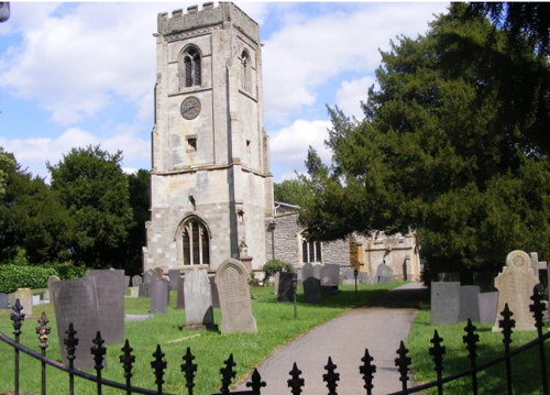
The Church of St Luke as it stands today dates back to the 14th Century and contains, amongst other important features: one of only two priest brasses in the county dated 1521; important Anglo-Scandinavian relics including two coffin lids (one is believed to have been fashioned from a pillar from a Roman Villa and the second features a rare Tree of Life sculpture); locally important Belvoir Angel Headstones from the 1700s with the largest clusters found in Hickling and the immediate vicinity.
The Black Death (1349) and subsequent plagues and epidemics brought a swing away from arable production and towards grasslands and grazing. By the late 18th Century, the Vale of Belvoir was recognised for the breeding and fattening of cattle.
The enclosure acts of the late 1700s introduced more hedgerows and the modern pattern of the area’s field systems. The rebuilding of the village in brick took place during the 18th and 19th centuries and continued into the 20th Century. This began with the houses of the nobility and gentry, and by the late 18th Century, it was usual for the humblest of new dwellings to be built in brick.
Gradually, during the 18th and 19th centuries, the old styles of buildings with timber frames or of mud-and-stud construction and thatched roofs were replaced, or encased, in brick with pantile and some plain tile roofs. The last cruck-built cottage in Hickling was taken down in the 1960s when it became unsafe.
Local clay pits and brick kilns were often the source of bricks. Stone building was also a lesser feature of this region, taking advantage of the limestone outcrops in and around it.
The Grantham Canal was built in the late 18th Century (completed 1797), which brought with it the canal basin, Lengthman’s Hut, Canal Wharf Building, the Navigation Inn (now Bridge View) and the Canal Weighing Office, all of which remain today. The canal would have also brought building materials that were not available in the immediate locality.
The current manifestation of the tradition of mixed farming, especially much of the openness of the arable areas, has been created by boundary clearance in the latter decades of the 20th Century. The fundamental characteristics of the region, however, are a continuity of land use and settlement pattern going back to Late Saxon times and perhaps even earlier.
The agricultural vitality of the region, extensive cultivation with much animal husbandry, and lack of woodland are dominant themes which were established early and have influenced its landscape in every generation of its history.
There is growing evidence of the potential for significant archaeological finds within the Hickling Conservation Area, largely due to the amount of undisturbed pasture, orchards and gardens within Hickling and its immediate vicinity.
Hickling Parish Council and the village community have a strong commitment to exploring opportunities for archaeological investigation in partnership with Nottinghamshire County Council’s Archaeological Services and would like to see such opportunities properly pursued in the early stages of any potential development.
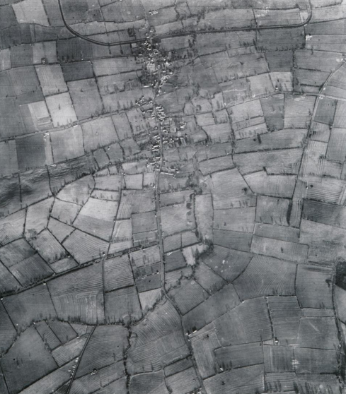
There are many examples of ridge and furrow field systems and earthworks within or adjacent to the Hickling Conservation Area. An aerial photograph of 1947 showing Hickling and its surroundings evidences where ridge and furrow was predominant.
A number of archaeological sites and ancient monuments exist, with some dating back to the Early Medieval and Post-Medieval periods. In addition, there have been recorded finds from the Roman period; for example, on Green Lane (just outside the Conservation Area), and Long Lane is a known route from the Roman era connecting with lanes to Willoughby and the Roman settlement of Vernemetum. Hickling also has strong links to the Civil War, and remnants from this era can be found on the Hickling Standard, in the Church and in residual property names.
There are no Scheduled Ancient Monuments.
3.2 Historical Mapping
4 Spatial Analysis
The relationship between open spaces and the built form within a conservation area can be central to its character. This section describes the village’s layout, highlighting the significant views, landmarks and historical focal points. The contribution of open green spaces, trees and other natural elements to the conservation area’s character is also described within this section.
4.1 Plan, Form and Layout
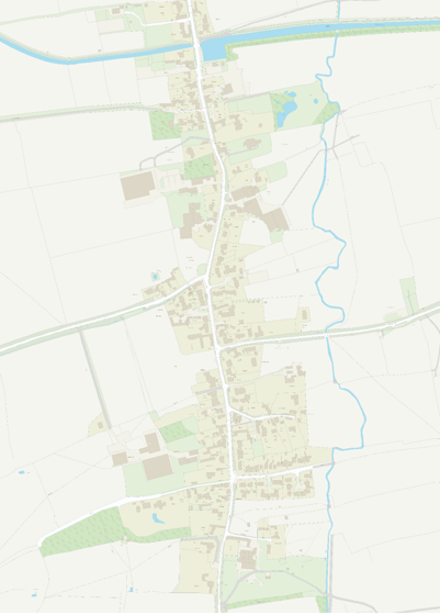
The early maps in Section 3.2 show Hickling with its traditional linear form with frequent areas where the surrounding countryside flows into Main Street. The road layout has remained much the same since these early maps, with Main Street forming the spine of the village and Mill Lane, Bridegate Lane, Clawson Lane, The Green, Long Lane, Pudding Lane and Wash Pit Lane all leading off to the East and West. The built form of Hickling has also retained the same pattern since at least the early 19th century. The only notable infill has occurred opposite Bridegate Lane and during the creation of Harles Acres in the 1960s/1970s. This infill has, however, been minimal and the village has retained its linear form and special character.
4.2 Landmarks, Focal Points and Views
The Hickling Conservation Area incorporates the majority of structures and their associated grounds within the village settlement.
The linear form of this settlement allows the surrounding countryside to have a very strong relationship with the village. The settlement is surrounded by fields on all sides, which flow seamlessly to Main Street, providing stunning views outwards and for a number of farm houses, these fields roll right up to the doorstep.
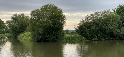
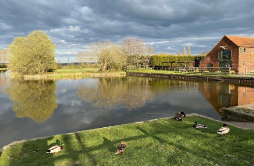
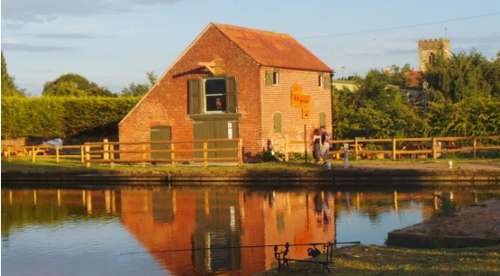
The Grantham Canal forms a strong relationship with the village as it flows through the Northern tip of the settlement, alongside the pub. The canal basin creates a strong focal point for the village and the community; the canal wharf building serves as a landmark for this special area, being prominently positioned next to the water.
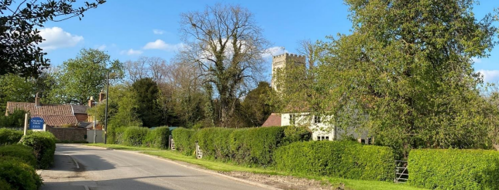
Another focal point is the Church of St Luke, which acts as a backdrop for a number of important buildings and viewpoints in the village.
The Church is also very prominent when observed from The Hickling Standard (trig point), where a dramatic view of the whole village can be enjoyed.
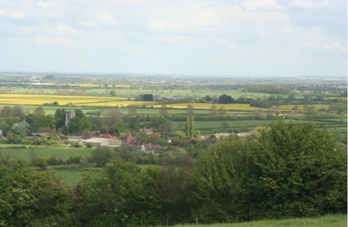
In addition, the open countryside that flows into the centre of the village provides many views outwards (including views across the Vale of Belvoir towards Belvoir Castle in the distance), and a particularly spectacular view can be found looking westwards, where Clawson Lane meets Main Street.
The Grantham Canal, lined with mature hedgerows, provides long, linear views down its visible course.
The Townscape Appraisal Map illustrates key views. However, it should be noted that the townscape appraisal is not a comprehensive account of every significant building, structure, tree, wall, feature, or space. Therefore, any omission should not be assumed to imply that they are of no interest.
4.3 Open Spaces, Trees and Landscape
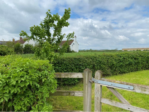
It is the open spaces within the Hickling Conservation Area that contribute to its special character. The relationship between the countryside and the built form of the village of Hickling is intrinsic to the character of the Hickling Conservation Area. Open countryside surrounds the built form of the village (up to and beyond the boundaries of the Conservation Area), and it flows into the village streets and lanes through gaps and open spaces. The entrances and exits to the village are all similarly characterised by open countryside.
In addition, glimpses of the surrounding countryside and the Hickling Standard are found throughout the village; between buildings and along tracks and lanes, and these enhance the rural character of the built form of the village.
The Grantham Canal and canal basin form an important public recreational space that is also of great biodiversity value.
The open space where Clawson Lane meets Main Street, with its two distinctive mature trees, wooden fence and horse paddock, is particularly attractive and instrumental in contributing to the special character of the Conservation Area.
Mature hedgerows line Main Street as it enters the village from both the North and South directions. A long stretch of mature hedgerow also runs along both sides of the road where Bridegate Lane meets Main Street (itself linking to a Site of Special Scientific Interest (SSSI) further along Bridegate Lane on the approach to the village) and, as with the open spaces, brings a countryside character into the centre of the village.
The grass verges that line many of the roads are also distinctively rural and are of importance to the character of the Conservation Area.
The Townscape Appraisal & the Hickling Neighbourhood Plan identify the positive open spaces.
There are many significant mature trees in the village, and these all play a role in framing key buildings, softening the built fabric and enhancing the special character of the village. The most significant clusters of trees are located on the grounds of the Church of St Luke, in the open space where Clawson Lane meets Main Street and along Long Lane and the wooded areas around it.
The most significant trees, positive open spaces, and grass verges are marked on the Townscape Appraisal map.
4.3.1 Open Spaces, Trees and Landscape SWOT Analysis
Strengths - what are the positives of the open spaces, trees, and landscape
- Strong connection to the countryside which flows into the village street through positive open spaces.
- The Grantham Canal, Basin, and towpath with open views into and out of the Conservation Area.
- Valuable clusters of old trees; for example, in the Churchyard (lime, poplar, yew) and moving south along Main Street including mature chestnut trees at Waterlane Farm and opposite Clawson Lane and mature orchards.
- Roads and lanes are characterised by native hedges and clusters of mature trees and natural grass verges
- Panoramic views of the village and its rural character from the trig point on The Hickling Standard.
- Walkers’ Green is now home to a small children’s playground in a natural setting with trees and hedges around it.
Weaknesses - what are the negatives of the open spaces, trees, and landscape
- The loss of trees and hedges through natural deterioration and changing conditions due to climate change.
- Increased pressures on the natural environment of the village from traffic, traffic volume and parking.
- Damage to and erosion of roadside verges from the increasing size and frequency of HGVs and modern farm vehicles accessing the village.
- Unnecessary light pollution affecting the tranquillity and quality of open spaces and the village environment.
- Modern hedge-cutting practices and verge management that has reduced biodiversity due to the frequency and close-cutting of field boundaries and roadside verges. It has also reduced the number of new trees becoming established in hedgerows and along roadsides resulting in a loss of tree cover over time when older specimens naturally deteriorate and die.
Opportunities – what could make the open spaces, trees, and landscape better?
- Manage the canal environment for the benefit of wildlife and tranquil leisure activities.
- Sensitive management and replacement of old or deteriorating trees and hedges with additional native tree planting along roads and lanes and in the form of new spinneys.
- Sensitive management to ensure the health and vitality of existing native hedges as wildlife habitats and to enhance the character of the Conservation Area.
- To use the Neighbourhood Plan and an active community to support and guide conservation issues through volunteer hours and grant funding; for example, support could be sought for landowners to maintain the open nature of positive open spaces and/or to manage significant trees/hedges.
Threats - what would make open spaces, trees and landscapes worse?
- The loss of open land flowing into the village; for example, deteriorating open spaces, orchards, gardens and the loss of spaces between buildings due to new housing development.
- Urban-style hedge and verge management that harms wildlife and wildflower habitat, including introducing and planting non-native species, which can damage the ecology and biodiversity of the area and undermine the area’s rural character.
- Loss of working farms affecting the rural character of the Conservation Area.
- Limited funding or external pressures may affect the management of the canal environment, impacting wildlife habitat, water levels and the quality of the area for quiet recreational enjoyment.
- Over-development of businesses and premises which contributes to an increase in intrusive traffic and parking and/or the loss of open / green space.
- An increase in road markings, signage and street furniture introducing a more urban character to the existing rural street scene.
- Planning applications which fail to demonstrate that they will not result in any significant loss in local tranquillity or residential amenity; for example, light pollution (in the use of floodlights, domestic lighting, security lights and street-lights resulting in excessive, misdirected or obtrusive uses of light) and/or noise pollution.
Works to Trees
You must contact the Local Planning Authority (LPA), Rushcliffe Borough Council before any works (cutting OR pruning) are carried out to trees within the Hickling Conservation Area.
Six weeks’ notice is required before any works to trees within the Conservation Area is carried out, even if they are not protected by a Tree Preservation Order (TPO).
Standard notification forms (a section 211 notice), further information and contact details.
A flow chart of the decision-making process regarding works to trees.
4.4 Public Realm
The boundary treatments that provide Hickling with its special character are the grass verges at the side of the roads, the buildings that abut these verges or the road itself and the established hedgerows. There are a number of short sections of brick wall that add to the historic character of the village, most notably along both sides of Main Street opposite the Church (helping to create a strong sense of enclosure) and along The Green next to the village hall. Significant walls and boundaries are marked on the Townscape Appraisal map.
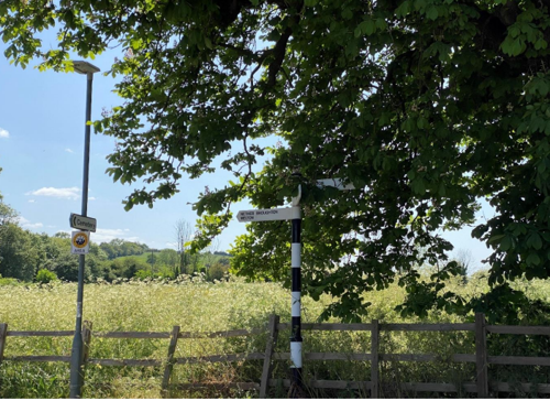
The many public footpaths, including the canal towpath, that lead into and out of the village are also key features of Hickling, which allow people to view, experience, and enjoy the village from the surrounding countryside.
Part of the rural character of the Hickling Conservation Area relies on the sensitive management of road markings, signage, and street furniture to reduce ‘creeping urbanisation’.
5 Buildings of the Conservation Area and Key Characteristics
5.1 Building Types and Activity
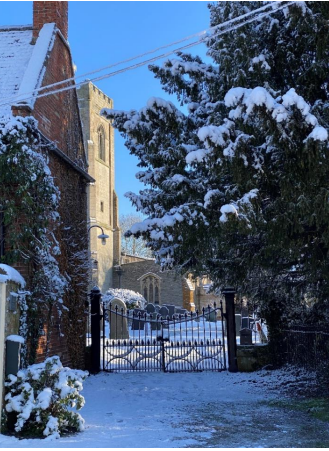
The oldest building in the village is the largely 14th Century Church of St Luke, which underwent three major periods of restoration in the 1800s. Important features include: one of only two priest brasses in the county dated 1521; important Anglo-Scandinavian relics including two coffin lids (one is believed to have been fashioned from a pillar from a Roman Villa, and the second features a rare Tree of Life sculpture); locally important Belvoir Angel Headstones from the 1700s with the largest clusters found in Hickling and the immediate vicinity. Bell ringing continues to be a feature of activities in the Church, and the church clock has recently been mechanised to secure its position at the heart of village life.
The Churchyard also contains several significant trees, including a black poplar and a cherry tree planted to commemorate Fred Maltby Warner who was born in Hickling and became the first non-American Governor of Michigan in the United States.
The Church continues to be strongly supported by the community and has benefitted from successful projects to maintain & protect the fabric of the building. However, like many rural churches it faces challenges; threats include the possibility of a move to a ‘Festival Church’ status or even closure.
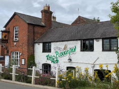
Other public buildings of note include The Plough Inn which pre-dates the arrival of the canal (completed in 1797) and is the last surviving pub in Hickling (at one time there were seven public houses in Hickling and Hickling Pastures, including the Wheel Inn and The Navigation Inn which are now private homes).
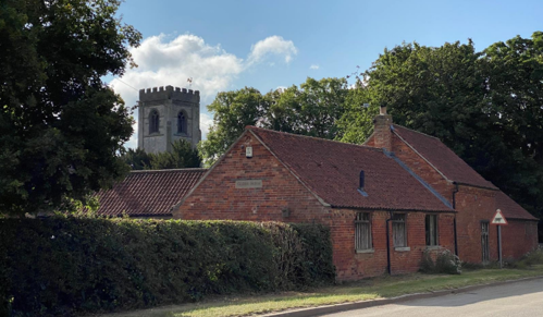
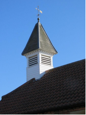
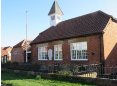
Also of note, is the Village Hall which was built in the 1830s as an early Church school and extended by local builders, Burnetts, in the 1870s to become a Board School. In the 1960s, the process began to transfer the building to the village for use as a Village Hall. In recent years the Village Hall has been sensitively extended and it retains its distinctive bell turret & high windows.
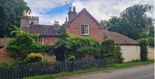
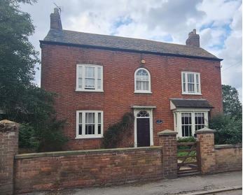
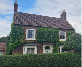
The oldest residential property in the village is Bowling Green Cottage (Grade 2 listed) on The Green which dates, in parts, to the 1600s.
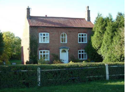
The older buildings within Hickling consist largely of detached Georgian houses, cottages, farmhouses, and outbuildings and many of these are indicated on the 1774 Enclosure Map of the village, with the 1815 map showing these individual buildings more accurately.
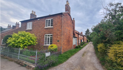
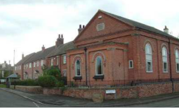
Many examples of 19th century farm cottages (often featuring Flemish bond brickwork and with mature gardens around them survive on Main Street and the roads and lanes leading from Main Street. These cottages occur throughout the village and provide a consistent, characteristic aspect which contributes significantly to the historic character of Hickling.
Mid-19th century brick cottages with Flemish bond brick work with burnt headers and shallow-pitched roofs. Long Lane is characteristic of several single-track roads which lead off Main Street.
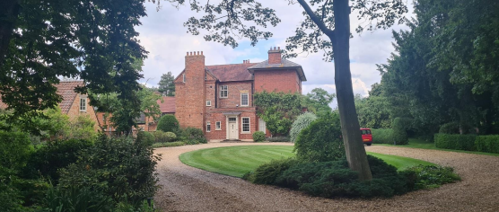
The buildings that line Main Street are largely one and two-storeys. A small number extends to three storeys. The large Manor House is taller, although this is offset by its distance from the road and its large grounds.
A number of buildings are also associated with the Grantham Canal, including Bridge View (Grade 2 listed), which was built in the early years of the canal and provided an inn (The Navigation Inn) and stabling linked to the canal.
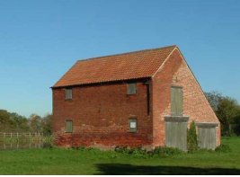
The Canal Wharf Building would have been built in the early 19th century; the pantile roof of this two-storey building almost reaches the ground on the southern elevation, and until recently, the building retained its three large service/delivery doors that provided both ground and first-floor access during the working life of the building.
In 2015 the Wharf Building was re-purposed to provide a small tearooms business with two small areas of outdoor seating and a community table tennis table. In addition, the Lengthman’s Hut (which lies along the towpath, east of the Basin and just outside the Conservation Area) has recently been restored and offers an interesting and valuable insight into the working life of the Grantham Canal.
Between Wharf House and the Wharf Building, there is the old Canal Weighing Office which has been restored and maintained by the owners of Wharf House. Although it is unused, it retains all its original features and continues to be an important feature of the canal area.
Additional features of note, include:
- The Old Methodist Chapel on the junction of Bridegate Lane and Main Street;
- The ‘Devil’s Stone’ Boulder, which sits on the pavement by the chapel;
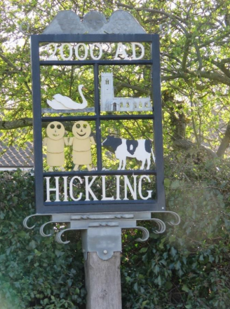
- The Millennium Village Sign, which was made by a local farmer and craftsman welcoming residents and visitors to the village as they approach down Bridegate Lane;
- Walkers’ Green which is a newly established children’s playground on the Bridegate Lane/Main Street junction sited on land donated by a local farmer for this purpose;
- Ordnance Survey benchmarks which remain on the outside wall of the church and the wall of Wolds Cottage, Bridegate Lane.
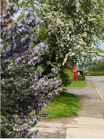
- The old K6-design red telephone box, which is now used to house a defibrillator; and the George VI post box, which is still in use opposite the Village Hall.
5.1.1 Building types and Activity SWOT Analysis
It is recognised that a village evolves over time as the needs of residents and business owners evolve and as technologies and global issues change. However, such changes should preserve and/or enhance the character of the Hickling Conservation Area.
Strengths - what activities/places can you go that make the village/town great?
- Thriving and varied community sustained by buildings such as the village pub and the village hall. A popular Pre-School is active in the Village Hall and serves several local villages. The sense of community is also enhanced by active village groups, social events and activities, and a strong culture of charity fundraising including an annual Scarecrow Festival.
- Positive buildings and positive landscape features continue to be most characteristic of the street scene.
- Canal and Basin; including canal wharf building and weighing office.
- Traditional farming village with working farms supporting the local Stilton cheese dairy in Long Clawson.
- Working businesses within the village including lively pub and café businesses.
- Walkers’ Green: a valuable children’s play area.
- Modern features held in affection by the community i.e. the Millennium village sign at the Bridegate Lane junction; and the K6-design telephone box repurposed to house a defibrillator.
Weaknesses - what activities/places exist that detract from making the village/town great?
- Hickling is dependent on a relatively old drainage and sewerage infrastructure; new building and non-porous surfacing to gardens and drives (for example) increase the risk of flooding and surface water problems.
- Lack of suitable affordable housing available for first-time buyers and those wanting to downsize.
- The volume, speed and size of HGV and other large farm vehicles contribute to the deterioration of grass verges and the gradual widening of roadways, impacting the safety of the community.
- No shop, doctors’ surgery, or primary school, and only a limited bus service.
- The recent demise of the cricket club has left the village without any active sports team.
- Increased traffic, congestion (as Hickling is used as a cut-through; for example, from Melton Road to Long Clawson and other neighbouring villages), and parking issues particularly around the basin area because of increased visitor numbers.
Opportunities - what activities/places could exist that would village/town even better?
- There is an identified need for small levels of affordable housing within the community; this could be fulfilled through the re-purposing of redundant farm buildings and brownfield sites. Reuse would minimise the impact on the positive open and green spaces.
- Grant funding for environmental projects and management.
- Modern materials and technology can facilitate the move towards green energy solutions; where available, there is an opportunity to minimise intrusion on the street scene.
- Modern materials and technology can facilitate the desirable inclusion of wildlife and environmentally friendly features within the design; for example, bat boxes and environmentally-friendly sourced materials.
- As modern farm and barn buildings are no longer used for their original purpose, these locations could be restored to the open landscape.
- Interesting modern design can be a positive part of an evolving street scene and sympathetic to its character. The character of the Conservation Area can be preserved or enhanced where modern design is ‘in scale’ and does not dominate or intrude upon existing positive features within the Conservation Area (reference can be made to the Hickling Neighbourhood Plan Design Guide).
Threats - what activities/places would make village/town worse?
- The loss of greenfield land.
- The loss of original features on older buildings.
- Unsympathetic development, which is out-of-scale and / or out-of-keeping with its surroundings and / or dominates its surroundings to the detriment of neighbouring properties and the wider Conservation Area.
- Over-development of individual locations resulting in a loss of green space and open-character.
- The use of building materials which are inappropriate in the Conservation Area; for example, UPVC windows on listed or positive buildings.
- Increased artificial surfacing to drives and gardens which has the potential to increase flood-risk and represents a loss of smaller green spaces within the Conservation Area.
- Insensitive installation of modern technology essential to tackling climate change (for example, solar panels), living with environmental changes (for example, air-conditioning units) or the modernisation of farming practices.
- More light pollution from an increasing number of domestic, farmyard and business lighting particularly from overbearing white lights.
- Loss of the church.
- The loss of positive buildings through neglect and disuse.
- Modern farming and food production practices emerging in the village in recent years, brought about by the necessary expansion associated with large-scale modern barn structures.
- Over-development of the canal basin and wharf area resulting in increased visitor pressure and associated problems resulting in urbanisation and loss of strong rural character and identity.
5.2 Key Characteristics and Building Materials
5.2.1 Key Characteristics: (Character Zone 1)
The Grade 1 listed church provides a visual, social and religious focal point for the local community and visitors and is located in a tranquil, rural setting. The church is an ancient building which has stood at the centre of the community for over a thousand years; it cares for a number of important historic (including Listed) features and monuments.
As well as St Luke’s Church, this character area also includes land associated with The Old Rectory, Glebe Farm and Glebe Cottage and the two cottages facing Main Street; Jessamine Cottage and Church Gates. It is likely that there has been a rectory on this approximate site since the Anglo-Saxon period; the present Old Rectory is Grade 2 listed, predominantly built in red-brick and it is set back from Main Street in its own grounds. Glebe Farm has been recently renovated and originally formed the outbuildings for the Rectory; the main part of the building was used as a Village Institute run and managed by the Rector for the benefit of the community. Glebe Cottage has similar historic links to the church and was, for some time, in church ownership with early 20th century occupants sometimes employed at The Rectory.
While the church is expensive to use and to maintain, there is strong community support in the form of fundraising and covenanted financial contributions. Festival Church status might improve the long-term prospects for the church building and community (a Festival Church is open for baptisms, weddings and funerals and is used for the main religious festivals and village events but not usually for regular Sunday services).
The church and its graveyard also represent a valuable open space in the centre of the village which provides a valuable wildlife and natural habitat. The graveyard is managed to support wildflowers and insects leading to interesting and valuable populations of birds and mammals (including resident colonies of bats) which, alongside the neighbouring fields and watercourse, considerably enhance the quality of the Conservation Area.
Materials
Walls: Predominantly 14th century stonework to the church, with thinly coursed stone with dressed ashlar tower. Elsewhere in this character area properties are predominantly red-brick sharing the characteristics of Zone 3.
Roofs: Lead to the roof of the church. Clay pantile is common to other properties within the character area.
Windows: The church has a mixture of stained glass and plain glass – all leaded. One plain glass leaded window (east-facing) features historic graffiti. Within the other properties, timber framed windows are predominant.
Doors: Church has an ancient oak door with delicate 13th century ironwork, Civil War musket holes.
Boundaries are mixed/rural; including brick and rendered walls and established native hedging. Wrought iron gates form an entrance to the church from Main Street.
Key Characteristics / Architectural Features:
The church building dates back to the 14th century and contains evidence of Anglo-Saxon settlement on the site (see also 3.1). The building has been restored and altered throughout its life – most recently in the early 20th century. The bells continue to be rung regularly and the recently modernised church clock still functions.
Elsewhere in the character area properties represent a cross-section of building types including the Grade 2 Listed Old Rectory which is set-back from Main Street within its own grounds. Also, a number of 19th century cottages and the converted rectory outbuildings which now make up Glebe Farm.
The churchyard, the Old Rectory and their environs contain a number of positive trees. The area to the east of Glebe Farm contains ancient fishponds and is actively managed for wildlife conservation.
The churchyard contains several Listed Monuments including the Mann Tomb and a cluster of historically important 18th century Belvoir Angel headstones.
5.2.2 Key Characteristics: Character Zone 2 2 - The Grantham Canal, Hickling Canal Basin, Wharf Building and Wharf Yard, and The Plough Inn and Bridge View
The Grantham Canal, Hickling Canal Basin, and the Wharf Building and Wharf Yard are situated at the north end of the village as Main Street moves into open countryside in the direction of Kinoulton. In combination with the Plough Inn, the area provides a focus for quiet leisure activities and for the enjoyment of the wildlife environment.
As identified on the Townscape Appraisal Map, the area includes key views in to and out of the area and represents a positive open space where the countryside flows into the village and onto Main Street.
From the wide public seating area alongside the Hickling Basin there are views down the Grantham Canal towards the row of black poplar trees as well as views across the open water of the Hickling Basin across the Vale of Belvoir and towards Belvoir Castle in the distance.
The area is also sensitive to adverse pressures, including increases in traffic and parking, the introduction of urban features and to over-development which risks undermining the rural character of the location.
Historically, the area would have experienced a steady flow of horse-drawn canal cargo traffic with produce for the immediate locality loaded and unloaded at the Wharf Building. As this use declined in the early 1900s, the area has evolved into a valuable wildlife environment which, due to its tranquillity and its accessible location, is valued by the community and visitors alike. There is potential to work with owners and local organisations on future projects to bring the canal back into use whilst safeguarding the serenity of the area.
The Plough Inn dates from the late 18th century and it pre-dates the Grantham Canal. It is a busy, traditional pub which is now independent (having been released, with community support, from brewery ownership in 2010). The Plough Inn has extensive outside spaces characterised by grass and native trees.
Grade 2 listed Bridge View is sited to the east of Main Street and looks over the canal basin. It was built in the early 19th century as the Navigation Inn which served those working on the canal with stabling and a second wharf for overnight mooring. As the canal fell into dis-use, the Navigation Inn closed as a public house in 1912; it retains many of its original features, including outbuildings.
The Grantham Canal, Hickling Canal Basin, the Wharf Building and Wharf Yard, and The Plough Inn represent a distinctive character area within the Hickling Conservation Area.
Materials
The Grade 2 Wharf Building is brick built with timber doors, windows and shutters, and a clay tiled roof.
The area also includes the gravelled towpaths, the man-made Basin boundaries, a brick and grassed ‘slipway’, and the natural vegetation of the canal banks.
The Plough Inn is a tall, red-brick, slate-roofed building which dates from the late 18th century (and pre-dates the canal). It has an extensive car park and a paddock area with mature trees which runs alongside the canal, east of Main Street.
Bridge View is Grade 2 listed and dates from the early 19th century. It is brick-built with a clay pan-tiled roof, a traditional symmetrical façade and a fan-shaped upper window. Many of the original outbuildings remain.
Key Characteristics / Architectural Features:
The open area comprising The Grantham Canal, Canal Basin, canal towpaths, Wharf Building and Wharf Yard is a significant focal point for the community and visitors seeking a tranquil setting and quiet recreational activities in an accessible location.
Key views along Main Street, towards the Church and open views along the canal and into the Vale of Belvoir characterise the area.
An important environment for wildlife (including a range of insects, amphibians, birds and mammals) and plant species. The canal supports a healthy fish population and is popular with anglers.
5.2.3 Key Characteristics: Character Zone 3 - Main Street (and the roads and lanes which join from the east and west)
Main Street and the roads and lanes linked to it, create a linear, rural character of development with established trees and native hedging, wide grass verges and open spaces where the countryside comes through into Main Street.
The built heritage consists mainly of traditionally built Georgian and Victorian houses, cottages, farms and farm houses which have mostly been maintained and sensitively updated, retaining original features and boundary treatments, and set within gardens and/or orchards.
There are a number of larger old properties (The Old Rectory, Waterlane Farm and The Manor, for example) which are set back from Main Street with orchards and gardens surrounding them. These represent a distinctive element within the historic architecture of the character zone.
The distinctive architecture and layout of older farm buildings (both operational and non-operational) runs throughout this character zone and the village as a whole. They contribute to the overwhelmingly rural character of the village and its farming heritage, connecting present-day residents and visitors with the village’s past. Working farms contribute significantly to the continuation of this rural farming character, the local economy, and, traditionally, to the management of the countryside for the benefit of wildlife, trees and plant-life.
It is important that this agricultural heritage has a positive impact on the village and any negative impacts are minimised; for example, the location, height and massing of agricultural buildings should be sensitive to neighbouring properties and also to views within the Conservation Area (e.g. the church), and views into the Conservation Area from surrounding public footpaths and the trig point on the Hickling Standard.
The need to maintain and update traditional properties presents a number of challenges within the Conservation Area. The use of potentially inappropriate modern materials (for example, unsympathetic styles of UPVC) negatively impacts the character of buildings. Properties built before cars have little or no provision for parking; some garden space has been lost to parking and parking from these properties necessarily impacts on Main Street.
Similarly, unsympathetic installation of technologies emerging as a result of changing climate which have the potential to intrude on the public domain; such as solar panels, air-source heat pumps and air-conditioning units have potentially negative impacts on the character of the Conservation Area.

Materials
Walls: Predominantly red brick with examples of Flemish Bond (for example, Jessamine Cottage). A small number of lightly coloured rendered brick. One notable outbuilding has a whitewashed brick finish (Forge Cottage). Bowling Green Cottage has a timber frame (late 17th century) with brick infill. Also including traditional brick-built farmhouses and outbuildings with new modern barns for housing livestock.
Roofs: Predominantly clay pantiles and Welsh slate with a small number of plain-tile roofs. There is also one notable and fine example of a Swithland Slate roof (The Elms Farmhouse, Main Street). This slate would have been sourced from Charnwood Forest and was also used for the Belvoir Angel headstones in the graveyard.
Windows: Timber sliding sashes, with many creating a symmetrical façade and having glazing bars and a number sliding horizontally.
Doors: Timber with many having six panels and a number being glazed, having fanlights and/or having wooden pilaster doorcases.
Key Characteristics / Architectural Features:
The dominant character on the roadside is a mixture of 18th and 19th century cottage-style and agricultural properties.
Farming and the farming community with their links to the Long Clawson Stilton Dairy are an important element of both the rural character and the day-to-day life of the village. Old brick-built farmhouses, barns and outbuildings from the 18th and 19th century are set in mature locations with trees, orchards and native hedges and/or brick boundaries. More recently, modern farming practices have introduced large barns to house milking herds which predominantly use york boarding for the walls and corrugated roofing.
The strong relationship between the countryside and the village street is created by the open countryside flowing into the village street and lanes through fingers of open spaces.
Glimpses of surrounding countryside and the Hickling Standard are found throughout the village, between buildings and along tracks and lanes.
The entrances and exits to the village are all similarly characterised by open countryside.
Narrow footpaths, single track lanes and both narrow and wide grass verges with established native hedgerows and traditional brick walls or railings as boundary treatments.
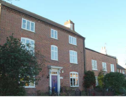
5.2.4 Key Characteristics: Character Zone 4 – Harles Acre (20th century development)
A small housing development which emerged in the 20th century consisting of modern family homes with drives, garages and gardens, and with established trees and green spaces. These properties are now 60 years old and some may need updating or renovating with the potential to incorporate innovative modern design and modern climate-friendly technologies.
Gradual incremental development in some of these areas includes extensions and hard-landscaping which can reduce green space or the open spaces between properties and which can increase flood-risk.
Materials
Walls: Red brick
Roofs: Tiled
Windows: Wooden or UPVC
Doors: Wooden or UPVC
Key Characteristics / Architectural Features:
The development of Harles Acres and Marsh’s Paddock in the 1960s was part of a national government led building scheme which brought new families into the village and helped village residents to remain in the village; benefitting the community and working locally.
At a similar time 3 houses of this type were built in the grounds of what was then known as East View (now Carneal Cottage) on the corner of Mill Lane.
Most houses are two-story-detached but there are also a small number of bungalows within Harles Acres. They were designed to have space around them and were built as family homes with a garage and a large family-sized garden.
Marsh’s Paddock (approximately 400 metres north of Harles Acre) consists of five houses which were built at a similar time to Harles Acre. Marsh’s Paddock however retains a building density that is more associated with Main Street than Harles Acre. The use of hedges and larger fore gardens also contribute to this.
The Hickling Neighbourhood Plan defines a ‘limits to development’ boundary, recognising the sensitivity of the linear form of the village and the importance of the rural character of the spaces between buildings.
5.2.5 Hickling Conservation Area: Zone Map
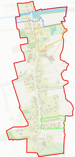
Key to Zone Map
- Zone 1 - Yellow dots: St Luke's Church and associated land.
- Zone 2 - Blue dots: The Grantham Canal, Hickling Canal Basin, Wharf Building and Wharf Yard, and The Plough Inn and Bridge View.
- Zone 3 - - Main Street (and the roads and lanes which join from the east and west) – the main street character zone is everything not identified within another character zone.
- Zone 4 - Green dots: Harles Acres
5.3 Listed buildings
Buildings on the Government’s List of Buildings of Special Architectural or Historic Interest are called “Listed” buildings and are protected by law. Consent is required from Rushcliffe Borough Council before any works of alteration, extension, or demolition can be carried out on any listed building.
Further information can be found in Rushcliffe Borough Council’s publication, Listed Buildings in Rushcliffe. The complete list of the can be found on Secretary of State’s Statutory List of Buildings of Special Architectural Interest or Historic Interest website.
Names and details of the Listed Buildings and structures in Hickling Conservation Area (correct as of April 2023) are detailed in Appendix 1. All Listed Buildings are shown on the Townscape Appraisal plan, but some smaller structures such as gravestones may not be shown.
5.4 Key Unlisted Buildings
Contribution to the established character of the place can also come from buildings which are not recognised via listing, or are not old. A plan with all of the positive contributions to the area can be found in Appendix 2 - Conservation Area Boundary and Townscape Appraisal Map. Both Planning Policy Guidance Note 15 (PPG 15) and English Heritage Guidance (English Heritage, 2005) stress the importance of identifying and protecting such buildings which enhance the character of the Conservation Area.
Almost 100 unlisted cottages, farmhouses and outbuildings have been identified on the Townscape Appraisal map (appendix 2) as having a positive impact on the character of the Conservation Area. The majority of these 18th and 19th century buildings have a strong relationship with Main Street and other side roads, with many abutting the grass verges or pavements and facing on to the street.
The Borough and Parish Councils encourage property owners to retain the original and/or traditional architectural details, building materials and positive features associated with their property.
The Borough and Parish Councils encourage property and landowners to be sensitive to the character of the Conservation Area when considering the installation of modern technology; for example, aerials, solar panels, air-source heat pumps, air conditioning etc. Advice can be sought from Rushcliffe Borough Council before proceeding.
The Hickling Neighbourhood Plan includes a detailed Design Guide which aims to protect and maintain the key characteristics which are important to the Conservation Area and which should be used for guidance.
5.5 Contemporary examples of sensitive development and/or restoration
It is important that the Conservation Area evolves over time and is not treated as a museum. Whilst development should be in keeping with the principles of the Conservation Area; sensitive restoration and innovative modern design can enhance the Conservation Area (see section 6) whilst, for example, copying like-for-like using modern materials can dilute our historic heritage. Important considerations include; scale in relation to neighbouring properties and the street scene, and impacts on the rural (as opposed to urban) character of the village (for example, introducing light pollution).
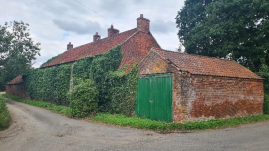
5.6 Buildings at Risk List
The ‘Buildings at Risk’ list includes (from north to south):
- The Canal Wharf Building which has important historic links to the Grantham Canal and retains many of its original features. It was developed into a small tearooms business in 2015 and the building is in good repair (see zone 1) although there is a risk from over-development which has the potential to undermine the historic and community significance of the building.
- Stables and outhouses linked to the old Navigation Inn (now Bridge View) which have an important historic link to the Grantham Canal, which retain many original features and which form a significant boundary feature to the Plough Inn.
- The Canal Weighing Office (adjacent to Wharf House) has important historic links to the Grantham Canal; it has been restored by the owners and the building is stable at the present time.
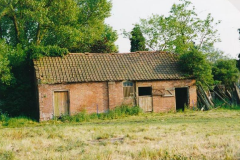
- The disused brick cow barn opposite The Old Rectory which is now largely overgrown and its future is ‘at risk’.
- The ‘Devil’s’ Boulder on the corner of Main Street and Bridegate Lane which is gradually being eroded by large vehicles as they negotiate the junction.
- Outbuildings adjacent to 3, The Green retain their original features but are now in disrepair.
- Outbuildings attached to The Orchard (on the corner of Main Street and Long Lane) which are in poor repair and at risk from the development of this location.
- Buildings to the north and west of The Homestead which retain their original features.
- Two outbuildings in the field close to the public footpath south of Long Lane which retain their original features.
- The outbuilding in open space at the entrance to Pudding Lane which is in poor repair but retains its original features.
- Outbuildings attached to Oak Farm (corner of Main Street and Pudding Lane) which retain their original features
Note:
- Outbuildings attached to Japonica Cottage’ which were previously identified as being ‘at risk’, have been incorporated into the main building as a part of the recent renovation of the property.
- The outbuildings adjacent to Blessings, The Green which are currently in good repair and retain their original features.
- The George VI post box built into the wall of the old Post Office (opposite the Village Hall).
- The disused K6-design red telephone box is valued by the community and has been re-purposed to house a defibrillator.
Buildings marked as being key unlisted building on the Townscape Appraisal map serve to preserve and enhance the character of the Hickling Conservation Area; their retention, continued use and/or sensitive renovation (including the retention of their original structure and historic features) benefits both the physical form and the function of the Conservation Area.
The buildings and features on the Townscape Appraisal that have not been marked as ‘key’ or ‘significant’ should not be taken to imply that they are of no interest or importance. It may therefore be preferable to retain neutral buildings and features. In some instances, however, neutral buildings and features may provide opportunities for enhancement that is in-keeping with the positive areas illustrated and described in the appraisal.
6 Generic Management Plan for Conservation Areas in Rushcliffe with Key References to the Hickling Neighbourhood Plan
6.1 Introduction
In carrying out its planning functions, the Borough Council is required in law to give special attention to the desirability of preserving or enhancing the character or appearance of Conservation Areas. The Management Plan for a Conservation Area is a tool to ensure the special character of the area is preserved and enhanced. The management plans aim to:
- Outline a strategic management proposal for the preservation and enhancement of the Hickling Conservation Area.
- Act as a guide for professionals and residents alike regarding:
- features of value, worthy of preservation;
- characteristics worthy of preservation;
- opportunities for enhancement;
- development proposals which preserve and enhance the special character of the area.
- Inspire community commitment to conservation principles and reporting.
The Hickling Conservation Area Boundary was reviewed and extended in 2007; it has not been altered in the current review (2023) although it is noted that the updated Conservation Area Appraisal is designed to operate alongside the recently adopted Hickling Neighbourhood Plan (2022). The Hickling Neighbourhood Plan includes a ‘building development line’ which supports the principles of the Conservation Area Appraisal.
In addition, the Hickling Neighbourhood Plan includes a design guide which outlines those development features which would protect and enhance the Hickling Conservation Area. Following this guide should result in a design approach that is acceptable within the Hickling Conservation Area; Rushcliffe Borough Council and Hickling Parish Council encourage residents to seek help and advice on these issues.
6.2 National and Local Policies and Guidance
There is a duty to formulate and publish management plans setting out policies and proposals for the preservation and enhancement of Conservation Areas. Many of these policies and proposals are common to all Conservation Areas, and these are set out in this document. The Central Government Guidance and Local policies applicable to Conservation Areas include:
- Hickling Parish Neighbourhood Plan 2011 - 2028 (adopted 2022)
- Rushcliffe Local Plan Part 1: Core Strategy, with a specific focus on:
- Design and Enhancing Local Identity [in part]
- Historic Environment
- Rushcliffe Local Plan Part 2: Development Policies, with a specific focus on:
- Conserving and Enhancing Heritage Assets
- Development Affecting Archaeological Sites
- The National Planning Policy Framework (NPPF), particularly, but not exclusively the chapter on Conserving and Enhancing the Historic Environment.
- The National Planning Practice Guidance (NPPG) (updated 2021 and subject to continual review)
- By Design: Urban Design in the Planning System – Towards Better Practice (2000)
- The Planning (Listed Buildings and Conservation Areas) Act 1990
- Historic England “Historic England Advice Note 1: Conservation Area Designation, Appraisal and Management”
The council will utilise the full range of strategic policy and guidance documents to ensure that development in Hickling Conservation Area is of a standard that enhances the amenity of the local area. The council will always look to use the most up-to-date versions of the document.
Supplementary documents may be issued for individual Conservation Areas where specific policies or proposals are needed.
6.3 Article 4 Directions
There are extra consents required in Conservation Areas. For example, in addition to the general control of development, you will need to get permission for:
- Any additions or alterations to the roof (for example, dormer windows)
- The installation of satellite dishes on chimneys, roofs or walls fronting a highway
- Any extension which extends beyond the side of the original dwelling house
- Any extension of more than one storey that extends beyond the rear wall of the original dwelling house
- Cladding the exterior of the dwelling
- Any demolishing of a building or part of a building that has a volume over 115 cubic metres.
Article 4 of the Town and Country Planning (General Permitted Development) Order 1995, allows planning authorities to restrict some permitted development rights within particular areas. This does not necessarily prevent development or change taking place but enables the Local Authority to manage the design and detailing of the works, and potentially grant permission subject to appropriate conditions. The use of Article 4 Directions will be proposed where it is considered appropriate following the completion of each Area Appraisal across the Borough.
Details of Article 4 Directions for Hickling Conservation Area.
There are currently no Article 4 Directions for Hickling Conservation Area.
6.4 Building Design
Mimicking the local vernacular is not the only way to ‘fit in’ with the character of a conservation area. National policy makes clear that contemporary designed, provided it is sympathetically designed, cannot be dismissed as an option. Therefore, good contemporary design will be encouraged where it respects the context’s character, scale and massing. This must be demonstrated in the Design and Access Statement submitted with any planning application.
Extensions to buildings in Conservation Areas should respect:
- The key characteristics of the original building, including scale, mass, materials and proportions
- The contextual setting and character of the Conservation Area
Copying like for like can devalue and destroy the ability to “read” historic change, and dilutes our historic heritage. Pastiche designs, incorporating poor imitations of other styles, will be resisted, particularly where they incorporate details which are not locally appropriate. Careful high-quality replication may be required in a few very sensitive locations.
In particularly sensitive locations, such as uniform terraces, exact replication may be necessary to maintain compositional unity. In that case, attention to details, choice of materials and high-quality workmanship are the keynotes. However, in some cases, a direct relationship is not impossible. For example, Flemish Bond brickwork cannot be replicated in cavity walls, and narrow lime mortar joints cannot be replicated in modern metric brickwork.
6.4.1 Re-use and adaptation of old buildings
The Hickling Neighbourhood Plan outlines that where planning permission is required for the re-use and adaptation of redundant or disused rural buildings for residential use (see policy H12). Following this policy should effectively achieve the core principles of the conservation area designation.
The Hickling Neighbourhood Plan also supports the re-use, adaptation or extension of rural buildings for business under certain conditions (see policy H16).
Where new building is appropriate or where an existing building detracts from the character of the area, the opportunity should be taken to re-establish the streetscape, reinforce enclosure, open up distant vistas or views of landmarks or hide unsightly views.
“New and old buildings can coexist happily without disguising one as the other, if the design of the new is a response to urban design objectives” (DETR – “By Design”, p19).
As with extensions, good contemporary design which respects local character, and the context of the site will be encouraged.
All new buildings should respond appropriately to the existing frontage and normally follow the established building line. Development or redevelopment will normally be resisted if:
“it blocks important views identified in the individual appraisals, uses important open spaces identified in the appraisals, adversely affects the setting of any Listed or key buildings, fails to maintain or re-establish the streetscape where appropriate dominates its Conservation Area background fails to recognise the context of the site destroys important features identified in the individual appraisals such as boundary walls, fences, hedgerows or trees”
Where the quantity of contemporary schemes in a small area becomes significant and outnumbers older buildings within the area, further contemporary schemes could fundamentally shift the architectural character of the area and thus be harmful, even if well designed as an individual project.
New development that stands out from the background of buildings may be appropriate in exceptional circumstances if it contributes positively as a landmark to enhance the street scene, to highlight a corner or to signal a visual change of direction such as along a curving vista.
Policy H5 of The Hickling Neighbourhood Plan outlines the existing network of local ecological features and habitats. Adhering to the tenets of Policy H5 should preserve or enhance the character of the natural landscape within the conservation area.
Any external lighting should be carefully designed and sited to minimise light pollution. Policy H3 outlines what is permitted to preserve and enhance the tranquillity of the area.
6.4.3 Microgeneration Technologies
While energy producing or saving devices are generally welcomed by the Borough and Parish Councils, careful consideration is required when these are to be located in a Conservation Area and some may require planning permission. In particular, they should be positioned to minimise their impact on the building and on the local amenity.
Only some microgeneration technologies projects, such as domestic solar PV panels, ground source and air source heat pumps may be permitted development. The installation of microgeneration technologies will require planning permission unless it can be evidenced that they fall within the acceptable limits as outlined in the General Permitted Development order.
6.5 Publicity and Knowledge Transfer
Ambiguity about additional controls within a Conservation Area raises the likelihood of inappropriate developments occurring which may damage the integrity of the conservation area designations.
Efforts have been made to engage local community groups in the development and review of the character appraisals. Empowering communities to define the special architectural and historic interest of the Conservation Area aims to raise awareness.
Whether the appraisal took a community-led or a council-led approach, upon reviewing all Conservation Areas, the public were invited to ask questions and comment during a public consultation. A consultation event also aimed to diminish any ambiguity about restrictions within a Conservation Area and increase the likelihood of sensitive and appropriate developments, maintaining the character of the area.
The council recognise the potential issues of turnover in residency and ownership of properties in the conservation area. Therefore, Rushcliffe Borough Council will periodically use their media outlets to highlight conservation area designations and the significant, related planning controls.
The approach taken within Hickling Conservation Area was with participation from Hickling Parish Council.
The consultation period took place between the following dates 21/08/2023 and 10/09/2023.
The date of the Consultation Event 04/09/2023.
If there are any queries about conservation areas, please email conservationareas@rushcliffe.gov.uk
6.6 Public Realm
General maintenance and upkeep to the public realm may include fixing damage to roads and pavements, and fixing issues with street lighting. Issues such as these can impact the quality of the Conservation Area.
The council aims to encourage works to the public realm that are in keeping with, or actively enhance the conservation area. Rushcliffe Borough Council can only advise on work within the public realm that does not require planning permission (for example work completed by statutory undertakers, such as the Highways Authority). In these instances, Rushcliffe borough council cannot prevent such work.
Nottinghamshire County Council are responsible for repairs to roads, pavements and street lighting. Report issues of repairs to roads, pavements and street lighting to Nottinghamshire County Council online.
Rushcliffe Borough Council will continue to undertake their duties in maintaining the public realm. Vandalism, fly tipping and street cleaning are all the responsibility of Rushcliffe Borough Council. Report issues to Rushcliffe Borough Council online.
Works to Trees
You must contact the Local Planning Authority (LPA), Rushcliffe Borough Council, before any works (cutting OR pruning) are carried out to trees within the Hickling Conservation Area.
Six weeks’ notice is required before any works to trees within the Conservation Area is carried out, even if they are not protected by Tree Preservation Order (TPO).
Standard notification forms (a section 211 notice) - further information and contact details.
A flow chart of the decision-making process regarding works to trees.
Tranquillity is significant to the rural character of Hickling. Policy H3 of The Hickling Neighbourhood Plan outlines what will be permitted as not to lose the local tranquillity.
National policy makes provision for local communities to identify green areas of importance to those communities, where development will not be permitted except in very special circumstances.
The following sites have been designated as Local Green Spaces:
- Canal basin, Hickling
- St Luke’s Churchyard, Hickling
- Walker’s Green, Hickling
- Cemetery, Clawson Lane, Hickling
- Land between Glebe Cottage and Waterlane Farm, Hickling
- Land opposite the junction of Clawson Lane and Main Street, Hickling
- Strip of land between Harles Acres and Pudding Lane, Hickling
- Land north of The White House, Main Street, Hickling
6.7 Boundary Treatments
Where there is a proposal for a new boundary treatment to be installed, the council would encourage the use of boundary treatments within the area.
Within conservation areas, planning permission is required to alter, maintain, improve, take down or build any new gate, fence, wall or other enclosure with:
- A height of one metre or more if next to a highway (including a public footpath or bridleway), waterway or open space; or
- A height of two metres or more elsewhere.
Where planning permission is required to remove a wall, Rushcliffe Borough Council will aim to protect those boundary walls and fences that have been identified as positively contributing to the area.
Hedgerows are significant habitats for wildlife in lowland Britain. Regulations are intended to protect important hedges in the countryside. The policy applies to hedges that are more than 20m long, (or less if connected to another hedge) on or adjacent to:
- Land used for agriculture or forestry, including the keeping of horses or donkeys
- Registered common land and village greens
- Local Nature Reserves and Sites of Special Scientific Interest.
The policy does not apply if the hedge is within or on the boundary of the curtilage of a house.
6.8 Buildings at risk
A few of the important buildings across the various Conservation Areas are currently vacant or not in regular use, which may lead to some being “at risk” of neglect or decay.
The Council will encourage and advise on renovation and repair work that is sensitive to the original or traditional historic character of the building and retains original features. The council will monitor the opportunity and potential for grant aid schemes to encourage the basic maintenance work necessary to ensure that key buildings within the conservation area are structurally sound and weather tight. However, given the current financial climate and outlook, such schemes are unlikely in the short to medium term.
There is a presumption against the demolition of buildings which contribute to the character of the area unless there are exceptional circumstances. It would benefit both the physical form and the function of the Conservation Area if these buildings were repaired, maintained and brought back into use.
Where the poor condition of a building or structure is as a result of neglect and lack of maintenance by its owner there is no requirement for the Borough Council to take its deteriorated condition into account when deciding whether demolition is appropriate. This is to avoid rewarding the deliberate neglect of buildings by representing such action as a way to obtain planning permission for demolition and redevelopment.
6.9 Enforcement
Rushcliffe Borough Council will, from time to time, assess and monitor changes in the appearance and condition of Hickling Conservation Area. This will ensure that where necessary enforcement action can be taken promptly to deal with problems as they arise.
The Borough Council may take formal action if the condition of any building (listed or unlisted) which makes a positive contribution to the character of the Conservation Area is considered to be at risk.
The Borough Council will work in accordance with their enforcement policy, which aims to provide an efficient enforcement service in support of the Borough Council’s statutory planning service. Rushcliffe Borough Council’s enforcement actions will remain transparent, consistent, and proportionate, as it is recognised that effective controls over unauthorised development assists in conserving the natural and built environment whilst helping to protect the quality of people’s lives and maintaining the Borough Council’s integrity.
7 Appendix 1 – Listed Buildings (as of February 2023)
Grantham Canal, 13 Miles Post, approximately 300 metres west of Main Street, Hickling
Grade: 2
Listing entry number: 1227662
National grid reference: SK 68777 29460
Location: Grantham Canal, 13 Miles Post, approximately 300 metres west of Main Street, Hickling
Grantham Canal, 13 1/4 Miles Post, approximately 150 metres east of Main Street, Hickling
Grade: 2
Listing entry number: 1227663
National grid reference: SK 69175 29507
Location: Grantham Canal, 13 1/4 Miles Post, approximately 150 metres east of Main Street, Hickling
Grantham Canal, 13 3/4 Miles Post, approximately 1,000 metres east of Main Street, Hickling
Grade: 2
Listing entry number: 1265242
National grid reference: SK 70033 29561
Location: Grantham Canal, 13 3/4 Miles Post, approximately 1,000 metres east of Main Street, Hickling
Grantham Canal, 14 3/4 Miles Post, approximately 500 metres north of New Canal Farm
Grade: 2
Listing entry number: 1227664
National grid reference: SK 70811 29280
Location: Grantham Canal, 14 3/4 Miles Post, approximately 500 metres north of New Canal Farm
Grade: 2
Listing entry number: 1265243
National grid reference: SK 71505 29434
Location: Grantham Canal, Aqueduct Over River Smite, approximately 800 metres south west of Long Clawson Bridge
Dell Farmhouse, Green Lane, LE14 3QF
Grade: 2
Listing entry number: 1227665
National grid reference: SK 67817 27369
Location: Dell Farmhouse, Green Lane, LE14 3QF
The Cottage, Main Street, LE14 3AQ
Grade: 2
Listing entry number: 1235606
National grid reference: SK 69143 28877
Location: The Cottage, Main Street, LE14 3AQ
Grade: 2
Listing entry number: 1265244
National grid reference: SK 69124 28942
Location: Chestnut House, Main Street
Grade: 2
Listing entry number: 1235617
National grid reference: SK 69141 29262
Location: Sulney Cottage, Main Street
Grade: 2
Listing entry number: 1227666
National grid reference: SK 69127 29268
Location: Jessamine Cottage, Main Street
Grade: 1
Listing entry number: 1264986
National grid reference: SK 69188 29279
Location: Church of St Luke, Main Street
Mann Tomb Chest immediately south west of Tower of Church of St Luke, Main Street
Grade: 2
Listing entry number: 1227667
National grid reference: SK 69179 29270
Location: Mann Tomb Chest immediately south west of Tower of Church of St Luke, Main Street
Grade: 2
Listing entry number: 1265245
National grid reference: SK 69172 29271
Location: Headstones in Churchyard of Church of St Luke, a group approximately 2 metres west of the Mann Tomb Chest, Main Street
Grade: 2
Listing entry number: 1264996
National grid reference: SK 69172 29277
Location: Headstones in Churchyard of Church of Church of St Luke, a group approximately 4 metres west of Tower, Main Street
Grade: 2
Listing entry number: 1235727
National grid reference: SK 69170 29250
Location: Two headstones approximately 10 metres from south fence of Churchyard of Church of St Luke south west of south aisle, Main Street
Grade: 2
Listing entry number: 1265246
National grid reference: SK 69168 29256
Location: Headstone in Churchyard of Church of St Luke approximately 20 metres south west of south aisle, Main Street
Headstones in Churchyard of Church of St Luke, a group immediately west of south aisle, Main Street
Grade: 2
Listing entry number: 1227668
National grid reference: SK 69182 29268
Location: Headstones in Churchyard of Church of St Luke, a group immediately west of south aisle, Main Street
Grade: 2
Listing entry number: 1227667
National grid reference: SK 69185 29260
Location: Group of headstones in Churchyard of Church of St Luke between south porch and west side of tower south of porch, Main Street
Effigy Base approximately 10 metres south of west end of south aisle in Churchyard of Church of St Luke, Main Street
Grade: 2
Listing entry number: 1227669
National grid reference: SK 69184 29257
Location: Effigy Base approximately 10 metres south of west end of south aisle in Churchyard of Church of St Luke, Main Street
Headstones in Churchyard of Church of St Luke, south of south aisle east of porch, Main Street
Grade: 2
Listing entry number: 1264930
National grid reference: SK 69194 29258
Location: Headstones in Churchyard of Church of St Luke, south of south aisle east of porch, Main Street
Grade: 2
Listing entry number: 1227670
National grid reference: SK 69166 29314
Location: The Rectory, Main Street
Stables immediately north west of The Rectory, Main Street
Grade: 2
Listing entry number: 1265247
National grid reference: SK 69155 29333
Location: Stables immediately north west of The Rectory, Main Street
Canal warehouse approximately 50 metres north north west of Wharf House, Main Street
Grade: 2
Listing entry number: 1235817
National grid reference: SK 69120 29438
Location: Canal wharf building approximately 50 metres north north west of Wharf House, Main Street
Grade: 2
Listing entry number: 1227671
National grid reference: SK 69053 29461
Location: Bridge View House, Main Street
Grade: 2
Listing entry number: 1235837
National grid reference: SK 69120 29188
Location: Church Farmhouse, Main Street
Grade: 2
Listing entry number: 1265248
National grid reference: SK 69110 29105
Location: The Elms Farmhouse, Main Street
Grade: 2
Listing entry number: 1235842
National grid reference: SK 69133 28733
Location: Mulberry House, Main Street
Grade: 2
Listing entry number: 1227672
National grid reference: SK 69139 28675
Location: Cobblestones, Main Street
Grade: 2
Listing entry number: 1264874
National grid reference: SK 69139 28662
Location: Malthouse Farmhouse, Main Street
Grade: 2
Listing entry number: 1227673
National grid reference: SK 69114 28376
Location: Elm House, Main Street
Grade: 2
Listing entry number: 1227674
National grid reference: SK 69220 28695
Location: Bowling Green Cottage, The Green
The titles of these listings may not make it clear that all listed buildings always include all attached structures and extensions, regardless of age, and all detached outbuildings built before 1st June 1948 which are, or were at the time of listing, ancillary to the function of the primary listed building and were in the same ownership at the time of listing.
For example, when a house is listed, the listing will apply to extensions, porches, detached historic stables, barns, wash houses, privies etc. Such outbuildings and extensions are only exempt from the provisions of listing where the listing specifically excludes them.
8 Appendix 2 – Townscape Appraisal

The Hickling Townscape Map above shows:
- Locations of listed buildings
- Locations of key unlisted buildings
- Open space
- Locations of trees, hedges, and significant hedges and fences
- Viewpoints
Conservation Areas
- Bingham Conservation Area
- East Bridgford Conservation Area
- East Leake Conservation Area
- Hawksworth Conservation Area
- Hickling Conservation Area
- Ruddington Conservation Area
- Thoroton Conservation Area
- Wiverton Conservation Area
- Langar Conservation Area
- West Leake Conservation Area
- Whatton in the Vale Conservation Area
- Costock Conservation Area
- Sutton Bonington Conservation Area
- Upper Saxondale Conservation Area
- Wysall Conservation Area
- Bradmore Conservation Area
- Car Colston Conservation Area
- Scarrington Conservation Area
- Orston Conservation Area
- Flintham Conservation Area
- Edwalton Conservation Area
- Aslockton Conservation Area
- Bunny Conservation Area
- Granby Conservation Area
- Keyworth Conservation Area
- Thrumpton Conservation Area
- Normanton on the Wolds Conservation Area
- Upper Broughton Conservation Area
- Screveton Conservation Area
- Kneeton Conservation Area
- Colston Bassett Conservation Area
- Cropwell Bishop Conservation Area