Hawksworth Conservation Area
Hawksworth Conservation Area Appraisal and Management Plan September 2022
Contents
1.1 Conservation Areas
1.2 The Purpose of a Conservation Area Character Appraisal
1.3 The Planning Policy Context
2 Hawksworth Location and Landscape Setting
3.1 Historical Overview
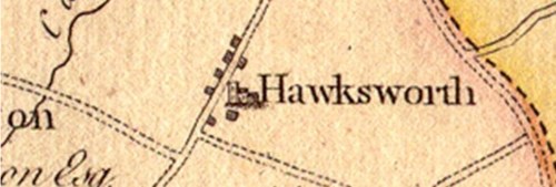
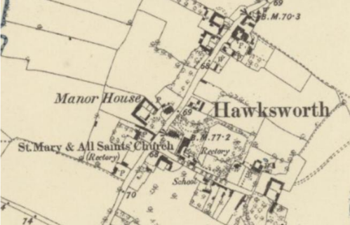
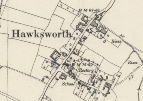
3.2 Historical Mapping
4.1 Plan, Form and Layout
4.2 Landmarks, Focal Points and Views
4.3 Open Spaces, Trees and Landscape
4.3.1 Open Spaces, Trees and Landscape SWOT Analysis
4.4 Public Realm
5 Buildings of the Conservation Area and Key Characteristics
5.1 Building Types and Activity
5.1.1 Building types and Activity SWOT Analysis
5.2 Key Characteristics and Building Materials
5.2.1 Key Characteristics: Character Zone 1 (Main Street)
5.2.2 Key Characteristics: Character Zone 2 (Town Street)
5.2.3 Key Characteristics: (Character Zone 3) Hawksworth Place and St Mary's Church
5.2.4 Key Characteristics: Character Zone 3 (Progress Works)
5.2.5 Key Characteristic SWOT Analysis
5.3 Listed buildings
5.4 Key Unlisted Buildings
6.1 Introduction
6.2 National and Local Policies and Guidance
6.3 Article 4 Directions
6.4 Building Design
6.5 Publicity and Knowledge Transfer
6.6 Public Realm
6.7 Boundary Treatments
6.7.1 Walls and Fences
6.7.2 Hedges
6.8 Buildings at risk
6.9 Enforcement
7 Appendix 1 – Listed Buildings
8 Appendix 2 – Conservation Area and Townscape Appraisal Map
1 Introduction
1.1 Conservation Areas
Rushcliffe Borough Council has an obligation under Section 69 of the Planning (Listed Buildings and Conservation Areas) Act 1990 to review, from time to time, its Conservation Area designations.
A Conservation Area, as defined under Section 69, is ‘an area of special architectural or historic interest the character or appearance of which it is desirable to preserve or enhance’.
Prior to this reappraisal of September 2022, the most recent appraisal of the Hawksworth Conservation Area prior to this one was carried out in February 2010.
Section 71 of the Planning (Listed Buildings and Conservation Areas) Act 1990 highlights the local planning authority’s duty to formulate and publish proposals for the preservation and enhancement of the conservation areas. This document, therefore, aims to identify and
reaffirm (or redefine) the special architectural or historic interest of the area which warrants its designation.
Conservation Area Appraisals are not, and never have been, tools for fossilising a place against change, instead, the processes of change which allow places to grow and evolve are recognised as being unavoidable, and it is also recognised that change can be a positive and desirable force. The designation instead allows greater scrutiny and control to manage change to positive effect and to ensure that any changes which require planning permission do not harm, and ideally serve to actively enhance, the existing character of the place.
Hawksworth Conservation Area: Summary of Special Interest
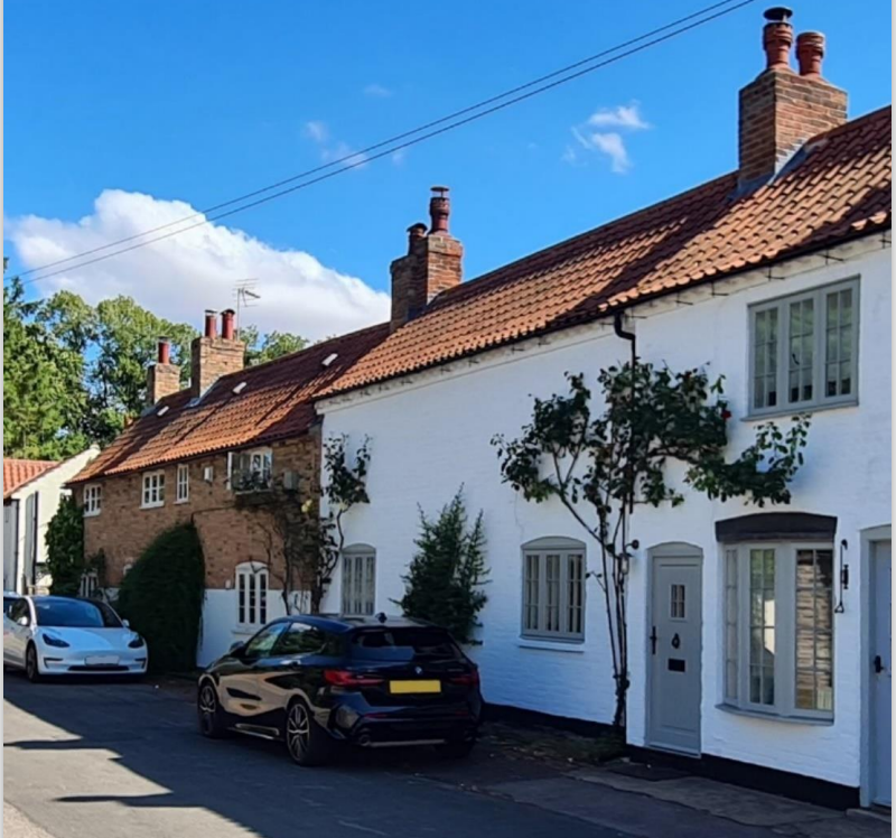
18th and 19th century red brick and pantile roof buildings throughout the village.
19th century W.B. Stubbs Engineering Works in the north of the village.
Norman church with 19th century brick tower.
Brick and stone walls define property boundaries along the highways.
Verges on entrances to and throughout the village, well maintained by village residents. Extensive daffodil displays along village verges.
Grass triangle at the top of Town Street with “Geoffrey's Tree” a focal point for meetings and social visits.
Good network of footpaths, bridle tracks and country lanes offering beautiful views of the village and countryside.
1.2 The Purpose of a Conservation Area Character Appraisal
The purpose of a Conservation Area Character Appraisal is to:
- Identify and record the special interest of the Conservation Area to ensure there is public awareness and understanding of what is worthy of preservation.
- To define and reassess current boundaries to accurately reflect what is now perceived to be of special interest.
- To identify opportunities to safeguard and enhance the special interest of the Conservation Area.
It should be noted that the content in this document is not a comprehensive account of every significant building, structure, tree, wall, feature, or space. Therefore, any omission should not be assumed to imply that they are of no interest.
Generally, the character and appearance of a Conservation Area will be preserved or enhanced by:
- Providing controls and regulating development through the planning system.
- Applying the extra controls that designation provides over demolition, minor development, and the protection of trees.
- Environmental enhancement schemes and possibly providing financial assistance for the repair and restoration of specific buildings.
- Encouraging public bodies such as the local highways authority or utility companies to take opportunities to improve the street scene through the appropriate design and sensitive sighting of street furniture (and retention of historic features of interest), or the removal of eyesores and street features that have a negative impact such as overhead wires.
1.3 The Planning Policy Context
This appraisal provides a firm basis on which applications for development within the Hawksworth Conservation Area would be assessed. It should be read alongside the wider development plan policy framework produced by Rushcliffe Borough Council and other National Planning Policy Guidance documents. The relevant documents include:
- Rushcliffe Local Plan Part 1: Core Strategy, with a specific focus on:
- Design and Enhancing Local Identity [in part]
- Historic Environment
- Rushcliffe Local Plan Part 2: Development Policies, with a specific focus on:
- Conserving and Enhancing Heritage Assets
- Development Affecting Archaeological Sites
- The National Planning Policy Framework (NPPF) (Revised -2021)
- The National Planning Practice Guidance (2016 - Subject to Continual Review)
- By Design: Urban Design in the Planning System – Towards Better Practice (2000)
- The Planning (Listed Buildings and Conservation Areas) Act 1990
Hawksworth Conservation Area: Summary of Key Issues
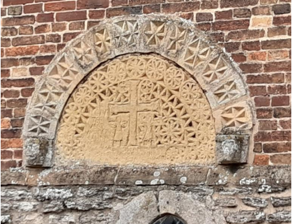
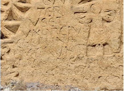
13th century Tympanum on south façade of church tower is being badly eroded – in need of intervention before features are lost.
Key unlisted buildings falling into disrepair through disuse e.g., Lilac Cottage.
Disease of trees becoming evident in cherry trees along Town Street, and Main Road to south of village, and some trees along Thoroton Lane.
Quality of road surface declining resulting in unsightly waste and potholes throughout village and creating considerable road noise.
2 Hawksworth Location and Landscape Setting
Rushcliffe Borough is located in the southernmost point of Nottinghamshire, and boarders Leicestershire. It is approximately half a mile south of Nottingham’s City Centre. The majority of the borough’s northern boundary is formed by the River Trent, while its western boundary is defined by the River Soar. In addition to this, two small watercourses run past Hawksworth: Back Dyke (to the east) and Car Dyke (to the west).
The Borough consists of mostly rural areas, but also a combination of market towns and villages. The A46, a notable Roman Road (the Fosse Way), runs through the centre of the Borough and leads to Newark in the North and Leicester in the south. In the northern half of the Borough, the A52 forms Nottingham’s primary transport link to Grantham and the East of England. Junction 24 of the M1 and East Midlands Airport are both located about 1 mile from the western border.
The borough consists of mostly rural areas, but also a combination of market towns and villages. The A46, a notable Roman Road (the Fosse Way), runs through the centre of the Borough and leads to Newark in the North and Leicester in the South. In the northern half of the Borough, the A52 forms Nottingham’s primary transport link to Grantham and the East of England. Junction 24 of the M1 and East Midlands Airport are both located about 1 mile from the western border.
Hawksworth is a small village parish situated in the northeast of the borough. It is adjacent to the villages of Flintham, Sibthorpe, Thoroton, Scarrington, and Screveton. Hawksworth is 4 miles northeast of Bingham, and 8 miles south-south-west of Newark. The A46 runs approximately 3 miles to the west of Hawksworth.
The village lies on the edge of the Vale of Belvoir, a name which derives from the Norman-French for ‘beautiful view’ and dates back from the Norman times (a period between 1066 -1154 CE).

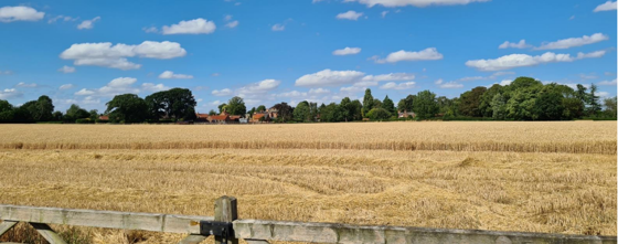
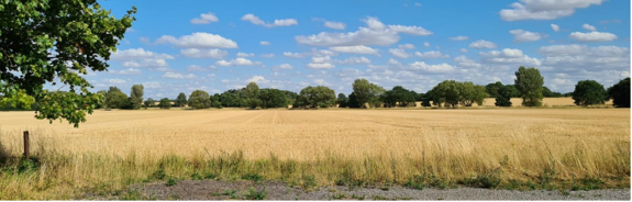
The village of Hawksworth is situated within the South Nottinghamshire Farmlands Character Area. The surrounding flat landscape allows for views across the landscape that has been divided into large arable fields (see Figure 2).
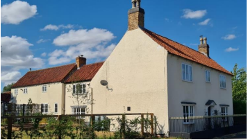
The rich farmland and adjacent fields make a considerable contribution to the village scene. The landmark of the church, the tower of Top Farm, other farm buildings and trees provide an attractive scene on approaching the village. There are also some particularly fine views over open countryside. From a point at the entrance to Top Farm’s grounds on Main Road for example, one can appreciate views over open countryside of the church spire at St Helena’s in Thoroton. Paddocks and small fields on the outskirts of the village provide a more traditional rural setting than intensively farmed arable land. The particularly fine architectural detailing of Top Farm suggests that not only was the village one with a strong agricultural foundation, but that farming on the fringes of the vale of Belvoir was both lucrative and profitable.
The village includes a high proportion of farms amongst its properties, with 5 farms within the relatively small village (Manor Farm, Top Farm, Yew Tree Farm, Philips Farm, Ivy Farm), again highlighting the importance of the agricultural connection of the village.
The size and setting of Hawksworth, with very few built structures immediately surrounding the village, means that the village is stumbled upon when approached by vehicle, bicycle or on foot.
- Conservation Area Boundary covers: 10.3 hectares (approximately)
- Number of Grade 1 listed buildings: 0
- Number of Grade 2* listed buildings: 1
- Number of Grade 2 listed buildings: 5
A full list of Hawksworth Conservation Area’s Listed buildings can be found in Appendix 1. Details accurate as of ???.
3 Historical Contexts
3.1 Historical Overview
Hawksworth’s early historical records are minimal, but the finding of a Neolithic axe head at Glebe Farm in 1916 provided proof of early human activity. Archaeological records similarly offer evidence of permanent settlement, which can be traced through the presence of earthwork features dating to the early medieval period.
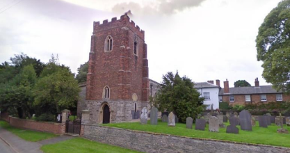
Hawksworth is recorded in the Domesday Survey of 1086 under the name of Hocheword. The Survey contains no mention of a church in the village. It is thought that a Saxon stone cross (the shaft of which still survives) was used to mark an open-air preaching site before the church was built. The lower stage of the church is early English, 13th century; however, the brick tower is of late 17th-century construction, and the nave and chancel were rebuilt in the early 19th century.
The south wall of the tower incorporates a Norman stone tympanum (a decorative semi-circular feature found over an entrance), no longer in its original position over the western doorway. The inscription reads “Gauterus et uxor eius Cecilina fecerunt facere ecclesiam istam in (h)onore ori uri et sce. Marie Virginis et omnium scorum dei simul”. This translates to Walter and his wife, Cecelina, caused this Church to be made in honour of Our Lord and of Saint Mary the Virgin, and of all God’s Saints likewise.
The parish register dates from 1554. Hawksworth was enclosed in 1761 when 150 acres were allotted instead of tithes. Later developments in the village’s built form include the establishment of the W. B. Stubbs Progress Works in 1836, a National School built in 1844 and a Wesleyan Chapel built in 1883.
3.2 Historical Mapping
4 Spatial Analysis
The relationship between open spaces and the built form within a conservation area can be central to its character. This section describes the village’s layout, highlighting the significant views, landmarks and historical focal points. The contribution of open green spaces, trees and other natural elements to the conservation area’s character is also described within this section.
4.1 Plan, Form and Layout
Below is a map that describes the current plan, form and layout of the village.
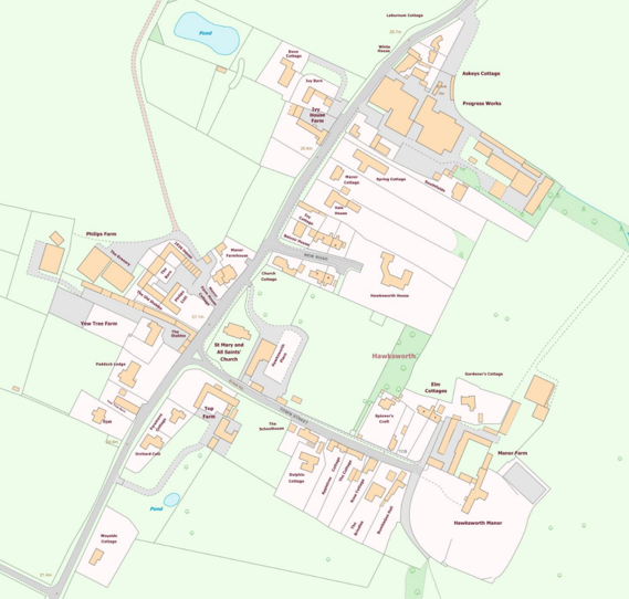
This map is reproduced from Ordnance Survey material with the permission of Ordnance Survey on behalf of the Controller of His Majesty’s Stationary Office © Crown Copyright. Unauthorised reproduction infringes Crown Copyright and may lead to prosecution or civil proceedings.
Rushcliffe Borough Council - 100019419
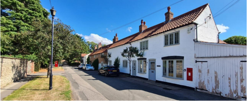
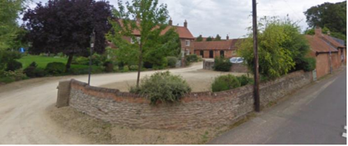
The majority of the buildings in Hawksworth are situated along two roads: Town Street, which extends approximately 200 metres east of Main road until coming to an end at Hawksworth Manor; and Main Road, which runs from south west (towards Scarrington) to north east (towards Sibthorpe). The only other adopted road in the village is New Road, established as recently as the 1970s. This small cul-de-sac also runs eastwards from Main Road from a point between Ivy Cottage and Church Cottage.
The larger properties in the village are often set their own grounds, while the smaller cottages and farmhouses are typically situated closer to the highway with large rear gardens. Converted farm buildings are a particular feature along the western side of Main Road. Many of the village’s buildings have elongated plan forms, which are sometimes arranged to form courtyards.
4.2 Landmarks, Focal Points and Views
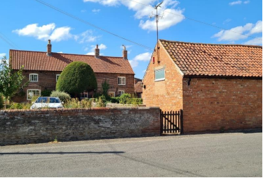
Church of St. Mary and All Saints (Figure 9), Top Farm’s tower (Figure 10), which stand in prominent positions near the intersection of Main Road and Town Street, are two of the most recognisable landmarks in the village. The church tower is a dominant feature, particularly in views from the south, with the tower from Top Farm occasionally visible behind other properties (Figure 11).
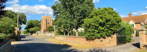
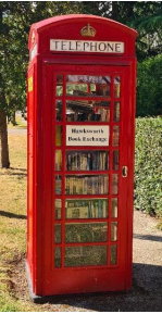
The vista along Town Street is notable, with the cottages, walls, grass verges and hedgerows framing views of Hawksworth Manor at the eastern end (Figure 12). The distinctive red K6 telephone box, originally designed to commemorate the Silver Jubilee of the coronation of King George V, now used as a Book Exchange (Figure 13). The post box along the same road also catches the eye.
There are a few vistas of the open countryside across open farmland at many points in the village. For instance, across the entrance to Top Farm’s grounds on Main Road. When the trees are not in leaf, it is possible to see the church spire at St Helena’s in Thoroton.
The Townscape Appraisal map illustrates these key views and other views which link the village to the adjacent countryside.
4.3 Open Spaces, Trees and Landscape
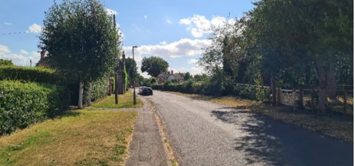
On the approach to the village, hedgerows combined with grass verges and trees contribute to its rural character. Through the many openings and above the hedges, there can be views across into the open countryside, with little to suggest a village nearby. At the edge of the village, from the access road adjacent to Laburnum Cottage there is a particularly fine view across farmland and open countryside.
Throughout the village, there are attractive open spaces which contribute to views of positive buildings and allow for views of the surrounding countryside.
The raised churchyard is particularly prominent at the centre of the village and includes a couple of attractive mature trees (below).
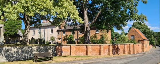
Adjacent to the Church of St Mary and All Saints and within the grounds of Hawksworth Place is a well-kept lawn along with a number of mature trees, some of which overhang onto the street and contribute to the character of the area.
Similarly, the grounds to the rear of Hawksworth Manor and the paddocks around Top Farm, Ivy House Farm and Yew Tree Farm help to link the village’s spaces to the surrounding countryside.
The most significant trees, hedges, open spaces, grass verges and gardens are marked on the Townscape Appraisal map.
4.3.1 Open Spaces, Trees and Landscape SWOT Analysis
Within smaller villages and larger towns there are publicly accessible open spaces which are not identifiable as formal parks but remain significant to public life. The SWOT Analysis below aims to identify such places, while also highlighting opportunities for improvement.
The results within the SWOT Analysis were received from Hawksworth Parish Meeting on 26th October 2022
Strengths - what are the positives of the open spaces, trees, and landscape
- Grass triangle at the top of Town Street with “Geoffrey’s Tree” a focal point for meetings and social visits.
- Verges on entrances and throughout the village, well maintained by village residents. Extensive daffodil displays along village verges.
- Good network of footpaths, bridle tracks and country lanes offering beautiful views of the village and countryside.
- Views out of the village reinforce its rural character and setting clearly defined from other settlements.
Weaknesses - what are the negatives of the open spaces, trees, and landscape
- Quality of road surface – degradation creating unsightly waste and potholes throughout village and creating considerable road noise.
Opportunities – what could make the open spaces, trees, and landscape better?
- Extend planting and wilding of verges within, and on outskirts of, village.
Threats - what would make open spaces, trees and landscapes worse?
- Disease of trees, becoming evident in cherry trees along Town Street, and Main Road to south of village, and some trees along Thoroton Lane.
• Any industrial development that impinges on the village setting within the countryside landscape.
Works to Trees
You must contact the Local Planning Authority (LPA), Rushcliffe Borough Council before any works (cutting OR pruning) are carried out to trees within the Hawksworth Conservation Area.
Six weeks’ notice is required before any works to trees within the Conservation Area is carried out, even if they are not protected by Tree Preservation Order (TPO).
Standard notification forms (a section 211 notice), further information and contact details.
A flow chart of the decision-making process regarding works to trees.
4.4 Public Realm
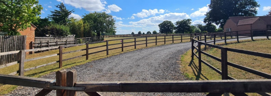
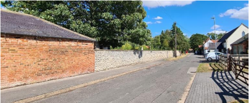
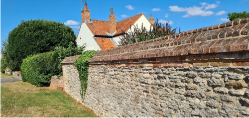
Boundary treatments in Hawksworth are a mixture of stone and brick walls of varying heights; hawthorn and privet hedges; wooden fencing; and metal railings. Grass verges are found throughout the village alongside the highways. Roads are surfaced with asphalt, but private drives are often surfaced with gravel giving a more informal, rural feel.
The raised churchyard is partly supported by a stone wall (the corner of Town Street and Main Street (see Figure 6)) and a brick wall. The recent buttresses added to the brick wall adjacent to Town Street have been done sensitively, matching the existing bricks closely (see Figure 16).
Significant walls and hedges are marked on the Townscape Appraisal map. Some images are shown below.
5 Buildings of the Conservation Area and Key Characteristics
5.1 Building Types and Activity
The older buildings in Hawksworth mainly consist of a mixture of farmhouses, cottages, Georgian houses, converted barns and outbuildings. Many of these can be seen on the historical maps shown in Figure 6.
5.1.1 Building types and Activity SWOT Analysis
The results of the SWOT Analysis were received from Hawksworth Parish Council on October 26th, 2022.
Strengths - what activities/places can you go to that make the village/town great?
- The various listed buildings
- The key unlisted buildings
- Residents can step out on to a network of footpaths and bridleways within a few yards of their properties
- There is very little traffic noise which contributes to the tranquillity of the area
Weaknesses - what activities/places exist that detract from making the village/town great?
- “Stone Croft” at the corner of Thoroton Lane in its current format (note planning approved for the site).
- Unused buildings becoming derelict including key unlisted buildings e.g. Lilac Cottage
Opportunities - what activities/places could exist that would village/town even better?
- None listed
Threats - what activities/places would make village/town worse?
- Enclosure of footpaths and bridleways
- Security lighting and light pollution that hampers the dark skies
5.2 Key Characteristics and Building Materials
5.2.1 Key Characteristics: Character Zone 1 (Main Street)
Materials
Walls:
- Many 18th and 19th century orange/red brick in various bonds and patterns.
- Earlier stone-walled buildings have all been altered or extended in some way using brick.
Roofs:
- Dominated by orange clay pantiles with a few examples of plain tiles and slate.
- Gable ends are mostly plain close verge where the tiles run to the edge of the brick gables.
- Parapet gable on Top Farm.
Windows:
- Predominantly Painted Timber window frames.
Doors:
- Various types of doors, including plank and batten, six and four panelled and part glazed.
- Many have iron door furniture.
Key Characteristics / Architectural Features:
A mixture of types, with Yorkshire sliding sashes and side-hung timber casements being the most common.
Many properties that front Main Street have hoods or porches.
5.2.2 Key Characteristics: Character Zone 2 (Town Street)
Materials
Walls:
- Predominantly 18th and 19th century brick in various bonds.
- Many of which are painted white, rendered or stuccoed.
Roofs:
- Predominantly orange clay pantile.
- A few in slate or clay tile.
- Predominantly close verge gable ends (with tiles running to the edge of the brick gable).
Windows:
- Predominantly painted timber window frames.
Doors:
- Various types of (mainly wooden) doors, including plank and batten, and part glazed.
Key Characteristics / Architectural Features:
Late 18th century two-storey detached and semi-detached cottages, many of which have side-hung timber casement windows.
Bow-fronted shop windows (The Old Post Office) iron casements with lozenge glazing bars (Hawksworth Manor).
Hawksworth Manor set in private grounds.
Former Wesleyan Chapel (1883) converted into residential.
Where the properties do not front onto the highway boundaries consist of hedgerows, brick, or stone walls.
Segmental arch lintel to many ground-floor windows and doors.
Panoramic views on to open countryside.
5.2.3 Key Characteristics: Character Zone 3 (Hawksworth Place and St Mary’s Church)
Materials
Walls: Coursed and squared rubble, dressed stone and brick.
Roofs: Slate, crenelated parapet to church tower.
Windows: Georgian sliding sashes (i.e. Hawksworth Place).
Key Characteristics / Architectural Features:
Mainly characterised by the large grounds in which the Church and Hawksworth Place sit.
Walled boundaries in both brick and stone. Brick supporting the church yard has recently had buttresses added.
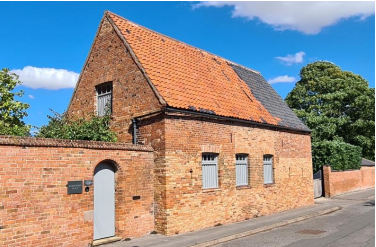
5.2.4 Key Characteristics: Character Zone 3 (Progress Works)
Materials
Walls: Building fronting the street built in brick in various bonds. Cross Flemish bond is evident in places, however, repairs make this less readable.
Roofs:
- Pantile
- corrugated steel, and fibre cement (or asbestos) to the modern industrial sheds.
Windows: Mid-Victorian arch iron window frames.
Key Characteristics / Architectural Features:
Mainly characterised by 19th century original brick buildings and modern industrial sheds.
Building fronting street
- Gable roof with close verge tiling. Two gable ends front Main Road.
- Predominantly stilted arch windows, but there are also segmental arch windows.
Industrial sheds adequately screened by vegetation and gates.
Key Characteristic Zone Map
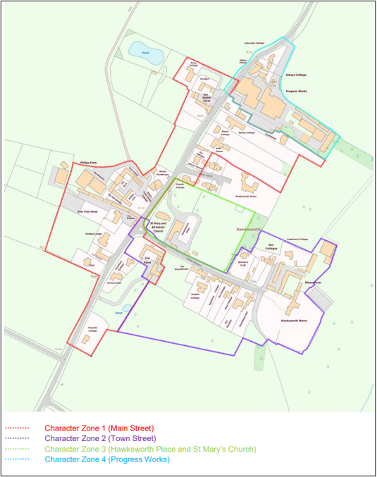
Key to Zone Map
- Red dots: Zone 1 - Main Street
- Purple dots: Zone 2 - Town Street
- Green dots: Zone 3 - Hawksworth Place and St Mary's Church
- Blue dots: Zone 3 Progress Works
5.2.5 Key Characteristics SWOT Analysis
The results within the SWOT Analysis were received from Hawksworth Parish Meeting on 26th October 2022.
Strengths - what is it about most existing buildings that looks good?
- None listed
Weaknesses - what is it about most existing buildings that does not look good?
- None listed
Opportunities - what could make existing buildings (or new builds) look good and contribute to the character of the area?
Threats - what could make existing buildings (or new builds) look worse and detract from the character of the area?
- Inappropriate or uncharacteristic developments or improvements (Not experienced in recent times).
- 13th century Tympanum on south face of church tower is being badly eroded – badly needs preserving before features are lost.
5.3 Listed buildings
Buildings on the Government’s List of Buildings of Special Architectural or Historic Interest are called “Listed” buildings and are protected by law. Consent is required from Rushcliffe Borough Council before any works of alteration, extension, or demolition can be carried out on any listed building.
Further information can be found in Rushcliffe Borough Council’s publication Listed Buildings in Rushcliffe.
The complete and up-to-date list of the Secretary of State’s Statutory List of Buildings of Special Architectural Interest or Historic Interest.
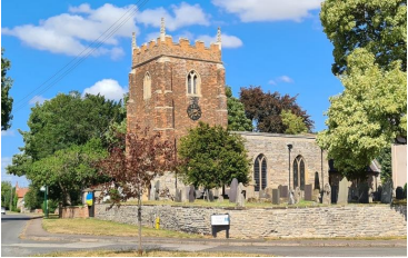
Coursed and squared rubble and brick church. Tower with 13th century base and brick addition 17th century. Clasping buttresses to the corners of tower. Slate roof hidden by crenelated parapet. Chamfered double lancet windows with Y tracery.
Tympanum showing Adoration of the Cross and an inscription has been re-set into south façade wall.
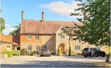
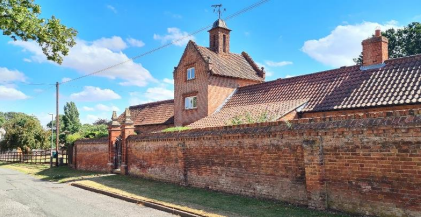
Mid-17th century manor house with rubble course and dressed stone quoins to front porch. Steep pitched roof. Mid-19th century two storey porch with dressed stone quoins. Late 19th century brick extension and windows. Iron casement windows with lozenge glazing bars.
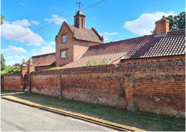
Model stable range with U plan with central yard. Brick with parapet gabled, hipped and lean-to pantile roof. Town street elevation has an off-centre tower of 3 storeys topped with a square bell turret. Four bays wide at longest section.
Late 17th century Farmhouse. Four uneven bays. Brick and coursed rubble. Pantile roof. Segmented arch to the top of Yorkshire sash windows.
5.4 Key Unlisted Buildings
Contribution to the established character of the place can also come from buildings which are not recognised via listing, or are not old. Below are a select number of key examples of positive contributions. A plan with all of the positive contributions to the area can be found in Appendix 2 - Conservation Area Boundary and Townscape Appraisal Map.
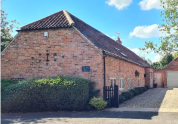
Barn converted to single storey dwelling. Pantile roof with hipped gable end to main road. Dentil course provides decoration to eaves.
Converted stable block built in brick with various bonds. Segmental arch to openings. Pantile gable roof with steep pitch.
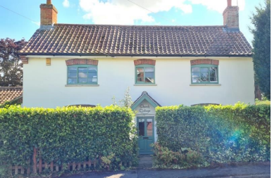
Two storey, three bay, cottage. Stucco finish with brick segmental arch top to Yorkshire sash (horizontal sliding) windows. Gable canopy to front door.
Stuccoed finish to exterior walls. Pantile roof gable canopy to front door (off main street).
6 Generic Management Plan for Conservation Areas in Rushcliffe
6.1 Introduction
In carrying out its planning functions, the Borough Council is required in law to give special attention to the desirability of preserving or enhancing the character or appearance of Conservation Areas. The Management Plan for a Conservation Area is a tool to ensure the special character of the area is preserved and enhanced. The management plans aim to:
- Outline a strategic management proposal for the preservation and enhancement of the Hawksworth Conservation Area.
- Act as a guide for professionals and residents alike regarding:
- features of value, worthy of preservation;
- characteristics worthy of preservation;
- opportunities for enhancement;
- development proposals which preserve and enhance the special character of the area.
- Inspire community commitment to conservation principles and reporting.
6.2 National and Local Policies and Guidance
There is a duty to formulate and publish management plans setting out policies and proposals for the preservation and enhancement of Conservation Areas. Many of these policies and proposals are common to all Conservation Areas, and these are set out in this document. The Central Government Guidance and Local policies applicable to Conservation Areas include:
- Rushcliffe Local Plan Part 1: Core Strategy, with a specific focus on:
- Design and Enhancing Local Identity [in part]
- Historic Environment
- Rushcliffe Local Plan Part 2: Development Policies, with a specific focus on:
- Conserving and Enhancing Heritage Assets
- Development Affecting Archaeological Sites
- The National Planning Policy Framework (NPPF), particularly, but not exclusively the chapter on Conserving and Enhancing the Historic Environment.
- The National Planning Practice Guidance (NPPG) (updated 2021 and subject to continual review)
- By Design: Urban Design in the Planning System – Towards Better Practice (2000)
- The Planning (Listed Buildings and Conservation Areas) Act 1990
- Historic England “Historic England Advice Note 1: Conservation Area Designation, Appraisal and Management”
The council will utilise the full range of strategic policy and guidance documents to ensure that development in Hawksworth Conservation Area is of a standard that enhances the amenity of the local area. The council will always look to use the most up-to-date versions of the document.
Supplementary documents may be issued for individual Conservation Areas where specific policies or
proposals are needed.
6.3 Article 4 Directions
There are extra consents required in Conservation Areas. For example, in addition to the general control of development, you will
need to get permission for
- Any additions or alterations to the roof (for example, dormer windows)
- The installation of satellite dishes on chimneys, roofs or walls fronting a highway
- Any extension which extends beyond the side of the original dwelling house
- Any extension of more than one storey that extends beyond the rear wall of the original dwelling house
- Cladding the exterior of the dwelling any demolishing of a building or part of a building that has a volume over 115 cubic metres
Article 4 of the Town and Country Planning (General Permitted Development) Order 1995, allows planning authorities to restrict some permitted development rights within particular areas. This does not necessarily prevent development or change taking place but enables the Local Authority to manage the design and detailing of the works, and potentially grant permission subject to appropriate conditions. The use of Article 4 Directions will be proposed where it is considered appropriate following the completion of each Area Appraisal across the Borough.
Details of Article 4 Directions for Hawksworth Conservation Area There are currently no Article 4 Directions for Hawksworth
Conservation Area.
6.4 Building Design
Mimicking the local vernacular is not the only way to ‘fit in’ with the character of a conservation area. National policy makes clear that contemporary designed, provided it is sympathetically designed, cannot be dismissed as an option. Therefore, good contemporary design will be encouraged where it respects the context’s character, scale and massing. This must be demonstrated in the Design and Access Statement submitted with any planning application.
Extensions to buildings in Conservation Areas should respect:
- The key characteristics of the original building, including scale, mass, materials and proportions
- The contextual setting and character of the Conservation Area
Copying like for like can devalue and destroy the ability to “read” historic change, and dilutes our historic heritage. Pastiche designs, incorporating poor imitations of other styles, will be resisted, particularly where they incorporate details which are not locally appropriate. Careful high-quality replication may be required in a few very sensitive locations.
In particularly sensitive locations, such as uniform terraces, exact replication may be necessary to maintain compositional unity. In that case, attention to details, choice of materials and high-quality workmanship are the keynotes. However, in some cases, a direct relationship is not impossible. For example, Flemish Bond brickwork cannot be replicated in cavity walls, and narrow lime mortar joints cannot be replicated in modern metric brickwork.
Where a new building is appropriate, on infill sites or where an existing building detracts from the character of the area, the opportunity should be taken to re-establish the streetscape, reinforce enclosure, open up distant vistas or views of landmarks or hide unsightly views.
“New and old buildings can coexist happily without disguising one as the other, if the design of the new is a response to urban design objectives” (DETR – “By Design”, p19).
As with extensions, good contemporary design which respects local character, and the context of the site will be encouraged.
All new buildings should respond appropriately to the existing frontage and normally follow the established building line. Development or redevelopment will normally be resisted if:
“it blocks important views identified in the individual appraisals, uses important open spaces identified in the appraisals, adversely affects the setting of any Listed or key buildings, fails to maintain or re-establish the streetscape where appropriate dominates its Conservation Area background fails to recognise the context of
the site destroys important features identified in the individual appraisals such as boundary walls, fences,
hedgerows or trees”
Where the quantity of contemporary schemes in a small area becomes significant and outnumbers older buildings within the area, further contemporary schemes could fundamentally shift the architectural character of the area and thus be harmful, even if well designed as an individual project.
New development that stands out from the background of buildings may be appropriate in exceptional circumstances if it contributes positively as a landmark to enhance the street scene, to highlight a corner or to signal a visual change of direction such as along a curving vista.
Any external lighting should be carefully designed and sited to minimise light pollution.
Energy producing or saving devices are generally welcomed by the Council, but careful consideration is required when these are to be located in a Conservation Area and some may require planning permission. In particular, they should be positioned to minimise their impact on the building and on the local amenity.
6.5 Publicity and Knowledge Transfer
Ambiguity about additional controls within a Conservation Area raises the likelihood of inappropriate developments occurring which may damage the integrity of the conservation area designations.
Efforts have been made to engage local community groups in the development and review of the character appraisals. Empowering communities to define the special architectural and historic interest of the Conservation Area aims to raise awareness.
Whether the appraisal took a community-led or a council-led approach, upon reviewing all Conservation Areas, the public were invited to ask questions and comment during a public consultation. A consultation event also aimed to diminish any ambiguity about restrictions within a Conservation Area and increase the likelihood of sensitive and appropriate developments, maintaining the character of the area.
The council recognise the potential issues of turnover in residency and ownership of properties in the conservation area. Therefore, Rushcliffe Borough Council will periodically use their media outlets to highlight conservation area designations and the significant, related planning controls.
The date of the Consultation Event 22/03/2022
If there are any queries about conservation areas, please email conservationareas@rushcliffe.gov.uk
6.6 Public Realm
General maintenance and upkeep to the public realm may include fixing damage to roads and pavements, and fixing issues with street lighting. Issues such as these can impact the quality of the Conservation Area.
The council aims to encourage works to the public realm that are in keeping with, or actively enhance the conservation area. Rushcliffe Borough Council can only advise on work within the public realm that does not require planning permission (for example work completed by statutory undertakers, such as the Highways Authority). In these instances, Rushcliffe borough council cannot prevent such work.
Nottinghamshire County Council are responsible for repairs to roads, pavements and street lighting. Report issues of repairs to roads, pavements and street lighting to Nottinghamshire County Council online.
Rushcliffe Borough Council will continue to undertake their duties in maintaining the public realm. Vandalism, fly tipping and street cleaning are all the responsibility of Rushcliffe Borough Council. Report issues to Rushcliffe Borough Council online.
Standard notification forms (a section 211 notice) - further information and contact details.
A flow chart of the decision-making process regarding works to trees.
6.7 Boundary Treatments
Where there is a proposal for a new boundary treatment to be installed, the council would encourage the use of boundary treatments within the area.
Within conservation areas, planning permission is required to alter, maintain, improve, take down or build any new gate, fence, wall or other enclosure with:
- A height of one metre or more if next to a highway (including a public footpath or bridleway), waterway or open space; or
- A height of two metres or more elsewhere.
Where planning permission is required to remove a wall, Rushcliffe Borough Council will aim to protect those boundary walls and fences that have been identified as positively contributing to the area.
Hedgerows are significant habitats for wildlife in lowland Britain. Regulations are intended to protect important hedges in the countryside. The policy applies to hedges that are more than 20m long, (or less if connected to another hedge) on or adjacent to:
- Land used for agriculture or forestry, including the keeping of horses or donkeys
- Registered common land and village greens
- Local Nature Reserves and Sites of Special Scientific Interest.
The policy does not apply if the hedge is within or on the boundary of the curtilage of a house.
6.8 Buildings at risk
A few of the important buildings across the various Conservation Areas are currently vacant or not in regular use, which may lead to some being “at risk” of neglect or decay.
The Council will encourage and advise on renovation and repair work that is sensitive to the original or traditional historic character of the building and retains original features. The council will monitor the opportunity and potential for grant aid schemes to encourage the basic maintenance work necessary to ensure that key buildings within the conservation area are structurally sound and weather tight. However, given the current financial climate and outlook, such schemes are unlikely in the short to medium term.
There is a presumption against the demolition of buildings which contribute to the character of the area unless there are exceptional circumstances. It would benefit both the physical form and the function of the Conservation Area if these buildings were repaired, maintained and brought back into use.
Where the poor condition of a building or structure is as a result of neglect and lack of maintenance by its owner there is no requirement for the Borough Council to take its deteriorated condition into account when deciding whether demolition is appropriate. This is to avoid rewarding the deliberate neglect of buildings by representing such action as a way to obtain planning permission for demolition and redevelopment.
6.9 Enforcement
Rushcliffe Borough Council will, from time to time, assess and monitor changes in the appearance and condition of Hawksworth Conservation Area. This will ensure that where necessary enforcement action can be taken promptly to deal with problems as they arise.
Where co-operation cannot be gained by any other means, Rushcliffe Borough Council has the ability to use additional enforcement powers to tackle particular issues within conservation areas. The Council may take formal action if the condition of any building (listed or unlisted) which makes a positive contribution to the character of the Conservation Area is considered to be at risk.
The council will work in accordance with their enforcement policy, which aims to provide an efficient enforcement service in support of the Council’s statutory planning service. Rushcliffe Borough Council’s enforcement actions will remain transparent, consistent, and proportionate, as it is recognised that effective controls over unauthorised development assists in conserving the natural and built environment whilst helping to protect the quality of people’s lives and maintaining the Council’s integrity.
7 Appendix 1 – Listed Buildings
Church of St Mary and All Saints
Grade: 2*
Listing entry number: 1243797
National grid reference: not given
Location: Church of St Mary and All Saints, Main Street, Hawksworth, Rushcliffe, Nottinghamshire
Hawksworth Manor and Adjoining Pigeoncote
Grade: 2
Listing entry number: 1243799
National grid reference: not given
Location: Hawksworth Manor and Adjoining Pigeoncote, Town Street, Hawksworth, Nottinghamshire
Hawksworth Place and Adjoining Garden Walls
Grade: 2
Listing entry number: 1272541
National grid reference: not given
Location: Hawksworth Place and Adjoining Garden Walls, Town Street, Hawksworth, Nottinghamshire
Grade: 2
Listing entry number: 1243798
National grid reference: not given
Location: Boundary Walls at Top Farm, Town Street, Hawksworth, Nottinghamshire
Model Farm Buildings at Top Farm
Grade: 2
Listing entry number: 1244181
National grid reference: not given
Location: Model Farm Buildings at Top Farm, Town Street, Hawksworth, Nottinghamshire
Yew Tree Farmhouse and Adjoining Garden Wall
Grade: 2
Listing entry number: 1243796
National grid reference: not given
Location: Yew Tree Farmhouse and Adjoining Garden Wall, Main Street, Hawksworth, Nottinghamshire
The titles of these listings may not make it clear that all listed buildings always include all attached structures and extensions, regardless of age, and all detached outbuildings built before 1 June 1948 which are, or were at the time of listing, ancillary to the function of the primary listed building and were in the same ownership at the time of listing.
For example, when a house is listed, the listing will apply to extensions, porches, detached historic stables, barns, wash houses, privies etc. Such outbuildings and extensions are only exempt from the provisions of listing where the listing specifically excludes them.
8 Appendix 2 – Townscape Appraisal
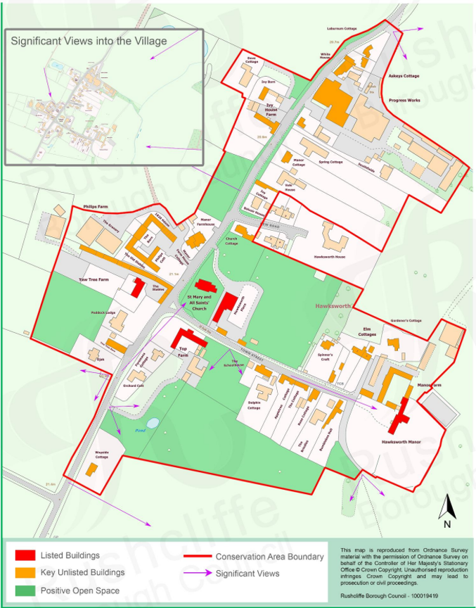
The Hawksworth Townscape Map above shows:
- Locations of listed buildings
- Locations of key unlisted buildings
- Open space
- Locations of trees, hedges, and significant hedges and fences
- Viewpoints
Conservation Areas
- Bingham Conservation Area
- East Bridgford Conservation Area
- East Leake Conservation Area
- Hawksworth Conservation Area
- Hickling Conservation Area
- Ruddington Conservation Area
- Thoroton Conservation Area
- Wiverton Conservation Area
- Langar Conservation Area
- West Leake Conservation Area
- Whatton in the Vale Conservation Area
- Costock Conservation Area
- Sutton Bonington Conservation Area
- Upper Saxondale Conservation Area
- Wysall Conservation Area
- Bradmore Conservation Area
- Car Colston Conservation Area
- Scarrington Conservation Area
- Orston Conservation Area
- Flintham Conservation Area
- Edwalton Conservation Area
- Aslockton Conservation Area
- Bunny Conservation Area
- Granby Conservation Area
- Keyworth Conservation Area
- Thrumpton Conservation Area
- Normanton on the Wolds Conservation Area
- Upper Broughton Conservation Area
- Screveton Conservation Area
- Kneeton Conservation Area
- Colston Bassett Conservation Area
- Cropwell Bishop Conservation Area