Bingham Conservation Area
Bingham Conservation Area Appraisal and Management Plan December 2022
Contents
1.1 Conservation Areas
1.2 The Purpose of a Conservation Area Character Appraisal
1.3 The Planning Policy Context
2 Bingham Location and Landscape Setting
3.1 Location and Historic Activities
3.2 Historical Mapping
4.1 Plan, Form and Layout
4.2 Landmarks, Focal Points and Views
4.3 Open Spaces, Trees and Landscape
4.3.1 Open Spaces, Trees and Landscape SWOT Analysis
4.4 Public Realm
5 Buildings of the Conservation Area and Key Characteristics
5.1 Building Types and Activity
5.1.1 Building types and Activity SWOT Analysis
5.2 Key Characteristics and Building Materials
5.2.1 Key Characteristics: Character Zone 1 - Urban Heart of the Conservation Area
5.2.2 Key Characteristics: Character Zone 2
5.2.3 Key Characteristics: Character Zone 3
5.2.4 Building Materials and Local Details
5.2.5 Key Characteristics SWOT Analysis
5.3 Listed buildings
5.4 Key Unlisted Buildings
6.1 Introduction
6.2 National and Local Policies and Guidance
6.3 Article 4 Directions
6.4 Building Design
6.5 Publicity and Knowledge Transfer
6.6 Public Realm
6.7 Boundary Treatments
6.7.1 Walls and Fences
6.7.2 Hedges
6.8 Buildings at risk
6.9 Enforcement
7 Appendix 1 – Listed Buildings (as of December 2022)
8 Appendix 2 – Townscape Appraisal
1 Introduction
1.1 Conservation Areas
Rushcliffe Borough Council has an obligation under Section 69 of the Planning (Listed Buildings and Conservation Areas) Act 1990 to review, from time to time, its Conservation Area designations.
A Conservation Area, as defined under Section 69, is ‘an area of special architectural or historic interest the character or appearance of which it is desirable to preserve or enhance’.
Bingham Conservation Area was designated in 1970. Prior to this current appraisal, the most recent appraisal of the Bingham Conservation Area was carried out in June 2010.
Section 71 of the Planning (Listed Buildings and Conservation Areas) Act 1990 highlights the local planning authority’s duty to formulate and publish proposals for the preservation and enhancement of the conservation areas. This document, therefore, aims to identify and
reaffirm (or redefine) the special architectural or historic interest of the area which warrants its designation. Conservation Area Appraisals are not, and never have been, tools for fossilising a place against change, instead, the processes of change which allow places to grow and evolve are recognised as being unavoidable, and it is also recognised that change can be a positive and desirable force. The designation instead allows greater scrutiny and control to manage change to positive effect and to ensure that any changes which require planning permission do not harm, and ideally serve to actively enhance, the existing character of the place.
Bingham Conservation Area: Summary of Special Interest
The large Market Place is an important public space at the heart of the Conservation Area.
The Grade 1 listed Church of St Mary and All Saints provides a landmark for the town.
Former agricultural buildings are easily identifiable throughout the town centre.
The rectilinear plan form may well date back to the 11th century.
Hedgerows, a paddock, native trees, grassy banks and wide grass verges give a verdant, semi-rural feel to parts of the Conservation Area.
A range of building types, sizes, heights, and ages provide variety and incident, while the predominance of local red brick for building walls and boundary walls provides unity.
1.2 The Purpose of a Conservation Area Character Appraisal
The purpose of a Conservation Area Character Appraisal is to:
- Identify and record the special interest of the Conservation Area to ensure there is public awareness and understanding of what is
worthy of preservation. - To define and reassess current boundaries to accurately reflect what is now perceived to be of special interest.
- To identify opportunities to safeguard and enhance the special interest of the Conservation Area.
It should be noted that the content in this document is not a comprehensive account of every significant building, structure, tree, wall, feature, or space. Therefore, any omission should not be assumed to imply that they are of no interest.
Generally, the character and appearance of a Conservation Area will be preserved or enhanced by:
- Providing controls and regulating development through the planning system.
- Applying the extra controls that designation provides over demolition, minor development, and the protection of trees.
- Environmental enhancement schemes and possibly providing financial assistance for the repair and restoration of specific buildings.
- Encouraging public bodies such as the local highways authority or utility companies to take opportunities to improve the street scene through the appropriate design and sensitive sighting of street furniture (and retention of historic features of interest), or the removal of eyesores and street features that have a negative impact such as overhead wires.
Bingham Conservation Area: Summary of Key Issues
The condition and design of buildings surrounding the Market Place. Specific reference is made to the condition of the Manor House.
Unsympathetic designs and ‘modernisation’ has had negative effects on, and degraded the appearance of, the Market Square.
Increasing traffic flow and demand for parking undermines the conservation area as an amenity.
1.3 The Planning Policy Context
This appraisal provides a firm basis on which applications for development within the Bingham Conservation Area would be
assessed. It should be read alongside the wider development plan policy framework produced by Rushcliffe Borough Council and other
National Planning Policy Guidance documents. The relevant documents include:
- Rushcliffe Local Plan Part 1: Core Strategy, with a specific focus on:
- Policy 10 (Design and Enhancing Local Identity) [in part]
- Policy 11 (Historic Environment)
- Rushcliffe Local Plan Part 2: Development Policies, with a specific focus on:
- Policy 28 (Conserving and Enhancing Heritage Assets)
- Policy 29 (Development Affecting Archaeological Sites)
- The National Planning Policy Framework (NPPF) (Revised -2021)
- The National Planning Practice Guidance (2015 - Subject to Continual Review)
- By Design: Urban Design in the Planning System – Towards Better Practice (2000)
- The Planning (Listed Buildings and Conservation Areas) Act 1990
2 Bingham Location and Landscape Setting
Rushcliffe Borough forms the southern tip of Nottinghamshire, which borders Leicestershire. It is predominantly a rural Borough that contains a mixture of city suburbs, market towns and villages. Rushcliffe is located about half a mile south of Nottingham city centre, with the River Trent forming the majority of its northern boundary and the River Soar defining its western boundary.
The Borough consists of mostly rural areas, but also a combination of market towns and villages. The A46, a notable Roman Road (the Fosse Way), runs through the centre of the Borough and leads to Newark in the north and Leicester in the south. In the northern half of the Borough, the A52 forms Nottingham’s primary transport link to Grantham and the East of England. Junction 24 of the M1 and East Midlands Airport are both located about 1 mile from the western border.
Bingham is a market town near the junction of the A46 (following an old Roman road, the Fosse Way) between Leicester and Newark-on-Trent and the A52 between Nottingham and Grantham. Neighbouring communities are Radcliffe-on-Trent, East Bridgford, Car Colston, Scarrington, Aslockton, Whatton-in-the-Vale, Tithby and Cropwell Butler.

- Conservation Area Boundary covers: 28.02 hectares (approximately)
- Number of Grade 1 listed buildings: 1
- Number of Grade 2* listed buildings: 0
- Number of Grade 2 listed buildings: 25
A full list of Bingham Conservation Area’s Listed buildings can be found in Appendix 1. Details accurate as of December 2022.
3 Historical Contexts
3.1 Historical Overview
Bingham town centre lies approximately 1.5km east of the A46, which was a Roman road, the Fosse Way. The Romans constructed the Fosse Way towards the end of 1st century AD to link Exeter and Lincoln. Margidunum, a former Roman settlement and Scheduled Ancient Monument, lies approximately 1.5km north of the centre of present-day Bingham. Margidunum was settled as a Roman fort in around AD 50-55, becoming a civilian settlement around AD 75.
To the north of Bingham is a henge monument buried beneath an industrial development. During the 1970s, protective clay was placed over the Henge, and the industrial estates’ car park was built over it. It is one of three Scheduled Ancient Monuments within the area surrounding Bingham. None are within the Conservation Area, but all receive strong protection from their scheduled designation.
Archaeological evidence further suggests prehistoric activity in the area surrounding Bingham. The Bingham Heritage Trails Association’s (BHTA) see www.binghamheritage.org.uk. History of Settlement project also found some prehistoric archaeological finds.
Recent archaeological work by BHTA has confirmed the connection of Warner’s Paddock to known Roman sites in Cherry Street. This helped confirm the suspicion that the Warner’s Paddock may well have a claim to being part of the original core of Roman and, hence, post-Roman Bingham.
A settlement of Anglo-Saxons followed the Romans’ departure from the area. The name Bingham is likely to have originated from this period. There are conflicting views on its original meaning; one suggests it means ‘homestead of the dwellers in a hollow’, another ‘homestead of Bynna’s people.’
Bingham appears in the Domesday Book of 1086 when its population was approximately 250.
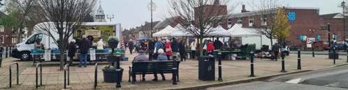
In 1314, Edward II granted Bingham a market right, which allowed the town to hold a regular market on a Thursday. The latter half of the 19th century saw a decline in the market's popularity, and it stopped towards the end of the 19th century. The market was reinstated in 1975 and continues to thrive today (see Figure 2).
A manorial survey of 1586 records four main open fields farmed on a strip holding basis. Two of these were Brackendale and Sternhill, whose names are preserved today in local farm names. These fields were gradually enclosed, and by 1820 the majority of the hedges around Bingham were in existence.
Bingham was predominantly a farming and market town and was served by at least 2 corn mills. With the increase in the use of bricks many villages or towns had their own brick works and there is evidence of one in Bingham during the latter half of the 18th century. A. L. Wortley’s A History of Bingham makes reference in 1769 to a ‘riotous assembly at Bingham brick kiln’.
During the Industrial Revolution Bingham remained predominantly rural. A small amount of weaving and framework knitting is known to have taken place, but apart from this no other manufacturing activities are recorded. The first railway line in Bingham was opened in 1850 and resulted in a small amount of development in Bingham, including housing for middle-class commuters. A second line, to the south of Bingham, opened in 1879. However, the population peaked at 2000 in 1851 and dwindled to just under 1500 by 1890. Bingham did not expand to any great extent until after the Second World War, with development continuing to this day.
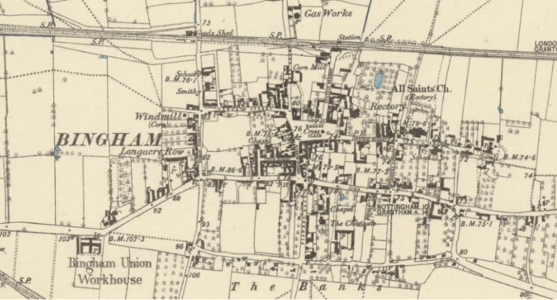
3.2 Historical Mapping
4 Spatial Analysis
The relationship between open spaces and the built form within a conservation area can be central to its character. This section describes the village’s layout, highlighting the significant views, landmarks and historical focal points. The contribution of open green spaces, trees and other natural elements to the conservation area’s character is also described within this section.
4.1 Plan, Form and Layout
The rectilinear layout of the core of the town around the Market Place is visible within Chapman’s 1774 map. While many of the original plots within this part of the conservation area have since been subdivided, the regular plan form is still evident within the northern part of the village. The result is a range of views/sight lines along key thoroughfares (Long Acre, The Banks, Jeb’s Lane/Cherry Street/ Church Lane, Fisher Lane/Market Street/Moor Lane) that help showcase both the architectural variety and historical development of the town. Newer developments south west of the Market Place do not follow the same grid pattern.
The principal east-west axis through the town is along Long Acre, with Church Street running parallel to the north and The Banks parallel to the south. These east-west routes are connected by shorter roads running north to south.
Apart from some commuter housing, Bingham saw little significant development throughout the 19th century until after World War II. Plots were subdivided and caused much of Bingham to develop as infill on previously open land. These developments were largely constrained by the railway line to the north and by the A52 to the south resulting in growth along the east-west axis.
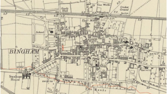
The map below describes the current plan, form and layout of centre of the town, of which the conservation area covers.
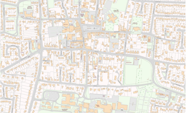
© Crown copyright 2023 OS licence number 100019419. You are permitted to use this data solely to enable you to respond to, or interact with, the organisation that provided you with the data. You are not permitted to copy, sub-license, distribute or sell any of this data to third parties in any form.
4.2 Landmarks, Focal Points and Views
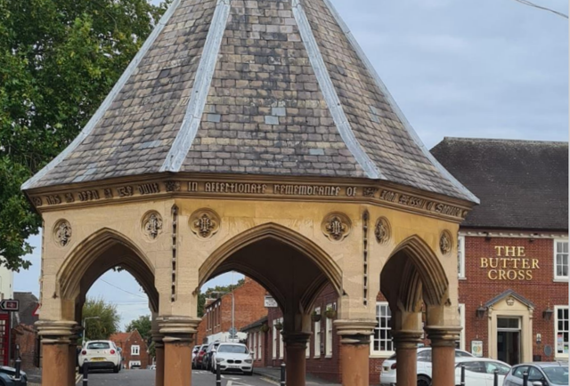
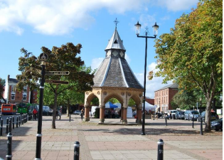
Constructed in 1861 in memory of John Hassall, the octagonal, Grade 2 listed Butter Cross (see Figure 6) is a focal point within the Market Place. The Butter Cross forms a ‘visual stop’ to the view down Station Street, while revealing itself gradually as one progresses towards the Market Place from Church Street.
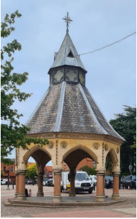
Built in 1861 in memory of John Hassall, the land agent who managed the Earl of Chesterfield’s many estates. The Butter Cross was designed by architect, T.C Hine.
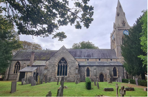
14th, 15th, 16th century course and squared rubble church with mid-19th century restorations. Slate roof. Tower has corner buttresses and a low parapet. Tower has double lancet windows with Y tracery. Clearstory quatrefoil windows are mid-19th century additions. Set back octagonal spire has three tiers of four lucarnes (a type of dormer window), each with a double lancet and a quatrefoil head. The steeple is visible from multiple locations across the town, see Figure 8 and Figure 9. Views are outlined on the townscape appraisal.
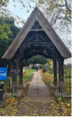
The churchyard’s distinctive Lych Gate (see Figure 10), emphasising the western entrance to the churchyard was designed by the artist George Francis Miles and built in 1881. George Francis Miles was the son of the rector of Bingham, a close friend of Oscar Wilde, and was a society painter admired for his portraits of Lillie Langtry.
4.3 Open Spaces, Trees and Landscape
The large open Market Place is one of the few public open spaces in the town centre and is at the heart of the Conservation Area.
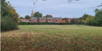
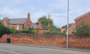
The churchyard contributes a small but attractive green space. Beyond the centre, the area becomes more verdant with trees, hedgerows, pasture, hollow way and grassy verges giving a semi-rural character to the eastern part of Long Acre and The Banks.
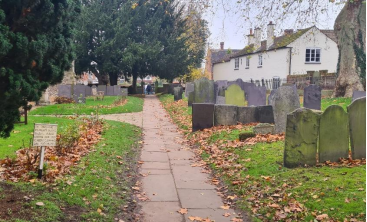
Bingham Cemetery (see Figure 13), a Victorian cemetery also designed as an arboretum with specimen trees is also an attractive open space.
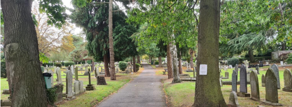
The entrance to the cemetery faces the hedgerow that borders Warner’s Paddock, the only remaining pastureland within the town centre. The paddock stretches from The Banks to Long Acre. Adjacent to Warner’s Paddock is West Field and the Bowling Club Green, both open green spaces for which the church spire is visible (see Figure 8).
4.3.1 Open Spaces, Trees and Landscape SWOT Analysis
The results within the SWOT Analysis were received from Bingham Town Council on 21st November 2022.
Strengths - what are the positives of the open spaces, trees, and landscape
- The continued rural appearance of the Banks with existing trees, old orchards, ancient hedge banks and wildflowers especially near the cemetery, Warner’s Paddock & Jebbs Lane.
- Similarly, the area of and around the churchyard, including Church Lane with its direct access to Butt Field.
Weaknesses - what are the negatives of the open spaces, trees, and landscape
- Unsympathetic infill in the past has degraded the appearance of the Market Square.
- The crumbling old Telephone Exchange building on Foster’s Lane, while sitting just outside the conservation area, dominates the view towards the church and Old Church House from some angles.
Opportunities – what could make the open spaces, trees, and landscape better?
- The cemetery was designed as an arboretum and a place of burial. More could be done to promote the cemetery as a place of peace and recreation.
Threats - what would make open spaces, trees and landscapes worse?
- The threat of new building on the surviving green spaces within the village, including Warner’s Paddock and Robert Miles School playing fields.
Works to Trees
You must contact the Local Planning Authority (LPA), Rushcliffe Borough Council before any works (cutting OR pruning) are carried out to trees within the Bingham Conservation Area.
Six weeks’ notice is required before any works to trees within the Conservation Area is carried out, even if they are not protected by a Tree Preservation Order (TPO).
Standard notification forms (a section 211 notice), further information and contact details.
A flow chart of the decision-making process regarding works to trees.
4.4 Public Realm
The open Market Place sits at the heart of the town centre. The buildings fronting the Market Place are mainly two to three storeys high, too low to provide a strong sense of enclosure to this large open space. However, there are few gaps in the building line, and some large imposing buildings to the north side. Consequently, the Market Place is reasonably visually contained. The pattern of development in the areas immediately surrounding the Market Place has historically been denser and remains so today, giving a more urban feel to this part of Bingham.
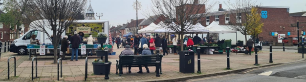
The Market Place in Bingham has been used as a market since it was granted Market Charter in 1314. Dormant from 1890, the market was revived on 10 July 1975. There have always been shops enclosing the Market Place and the newer of those present today replace older buildings that fell into decline.
The Market Place is currently surfaced in modern red and white concrete paviours, with some granite setts around the Butter Cross.
Mature trees, listed telephone boxes, and some substantial buildings set back considerably from the footpath adds to the dignified, more spacious character of the north side of Market Place.
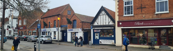
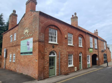
The HandiCentre DIY store is an example of an older building that encloses the Market Place. It was previously double storey cottage with its barn-like depository next door (the right of the two HandiCentre buildings). The building with the white gable end hard to the pavement was Downing the Butcher’s Shop, who used to run his own cattle. All three buildings now form the DIY store.
5 Buildings of the Conservation Area and Key Characteristics
5.1 Building Types and Activity
Bingham is home to a variety of building types, with the varied massing and scale of an old market town. While most of the buildings are two storeys, there are a number of single storey rural out buildings that have been converted to dwellings and a smaller number of three storey buildings.
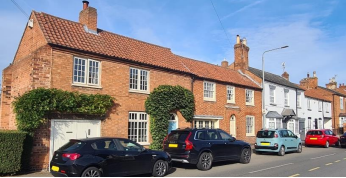
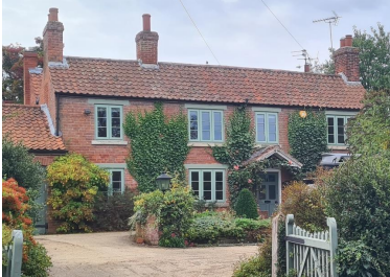
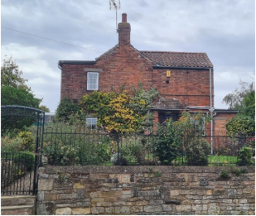
The evidence of historic buildings throughout the conservation area provides variety and incident. There are good examples of vernacular cottages, substantial Georgian houses, Victorian commuter housing, and rural outbuildings throughout the Conservation Area.
There is evidence that Bingham had its own brickworks from at least the late 17th century, and this would give rise to bricks being of a similar colour and size. There are some good examples of patterns being created by using different shades of brick.
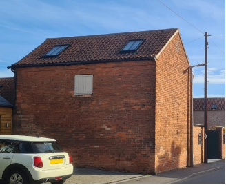
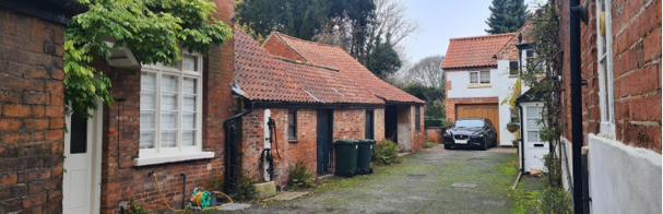
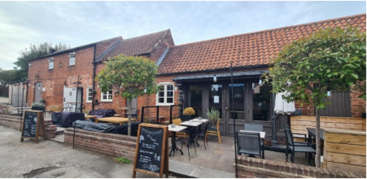
Much of Bingham’s special interest derives from the presence of former farm outbuildings within the town centre, providing a pleasing contrast with the bustling market town activity of today and linking the town with its agricultural past (see Figure 16 to Figure 18).
Double storey lean-to and single storey former agricultural outbuildings with external pump. Brick with pantile roof of varying pitches. Three unequal bays with an attached pump fixed to a timber case on the bay closest to the house. The pump has a scrolled iron handle and stone trough.
5.1.1 Building types and Activity SWOT Analysis
The results of the SWOT Analysis were received from Bingham Town Council on November 21st, 2022.
Strengths - what activities/places can you go that make the village/town great?
- Bingham has a lot of older buildings, many with interesting histories (as researched by BHTA and recorded on their website).
Weaknesses - what activities/places exist that detract from making the village/town great?
- Increasing traffic flow and demand for parking undermines the conservation area as an amenity.
Opportunities - what activities/places could exist that would village/town even better?
- In the context strengths, the 2010 conservation area boundary would benefit from extension.
Threats - what activities/places would make village/town worse?
- A failure to manage planning applications in a manner that supports and enhances both the integrity of older buildings and the overall character of the surrounding area.
5.2 Key Characteristics and Building Materials
5.2.1 Key Characteristics: Character Zone 1 - Urban Heart of the Conservation Area
Within this Character Zone, the urban heart of the conservation area, there remains a lot of evidence of Bingham’s agricultural past, with many former rural outbuildings being converted through a process of adaptive reuse, but their character remains.
Predominantly two storey buildings hard against the footpath. While many of the buildings that enclose the Market Place are 18th, 19th and early 20th century, the central positioning, scale and comparatively plain design of Eaton Place, a 1960/70s brick retail building, detracts attention from older buildings.
Materials:
Walls:
- Mainly red brick with some burnt headers visible on Flemish bonds
- Other walls painted white, or rendered in natural tones
- Variety of bonds, including Flemish bond with distinctive coloured headers. Manor House front elevation is built completely using header-bonding.
- Coursed stone and squared rubble (14th – 16th century Grade 1 Church)
Roofs: Slate and orange clay pantiles with a few examples of plain tiles.
Windows: Painted Timber window frames and White uPVC.
Key Characteristics / Architectural Features:
Mixture of uses typical to the urban core of a market town.
Former rural 18th and 19th century outbuildings adapted and converted evidence Bingham’s agricultural past. In some cases, these exist at the rear of the properties that front the street but are still clearly visible from the foot path (see Figure 18).
18th century Manor House fronting the Market Place which accommodates the 19th century Buttercross.
Grade 1 listed Parish Church (built between 14th and 16th century with 19th century restorations).
5.2.2 Key Characteristics: Main Village Street (Character Zone 2)
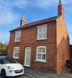
Much like the urban heart of the conservation area, this character Zone also has former agricultural buildings that have been converted into dwellings nestled within the more predominant Victorian commuter housing. While most of the buildings date between early 19th and early 20th century, there are some later 20th century infill developments.
Materials:
Walls:
- Mainly red brick, some buildings painted white and a few rendered.
- Variety of bonds to brickwork, Flemish bond is evident along Kirk Hill and Fairfield Street.
Roofs:
- A mix of slate, plain tile, and a few instances of orange clay pantiles.
- Many semi-detached and terraces have gable ends.
Windows:
- Mixture of windows including Sash windows, painted timber frame, and uPVC.
Key Characteristics / Architectural Features:
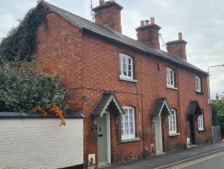
Former rural 18th and 19th century outbuildings adapted and converted evidence Bingham’s agricultural past. Mid 19th – early 20th century brick cottages.
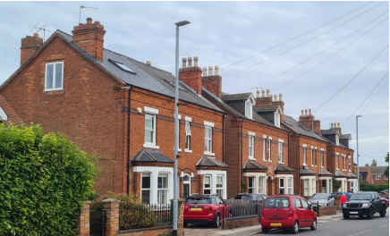
Semi-detached and terraced Victorian commuter housing. A number of Victorian houses still retain the margin lights, which were a popular in the late 19th century.
Many properties hard up to the foot path or with a small front garden.
There are many examples of stone lintels, often with a chamfered design, or brick lintels using a slightly arched row of brickwork, often using alternate blue brick in a soldier bond.
5.2.3 Key Characteristics: (Character Zone 3)
Materials:
Walls: Mainly red brick in various bonds.
Roofs: Orange/red clay pantiles with some slate and plain tile.
Windows: Mixture of windows with various panes, painted timber frame (neutral green) with some uPVC .
Key Characteristics / Architectural Features:
Characterised by mature trees, hedgerows, paddock, wide grassy banks and verges.
Verdant, semi-rural area, becoming slightly more suburban to west
Detached and semi-detached 19th and Early 20th century houses and former agricultural buildings with suburban front gardens.
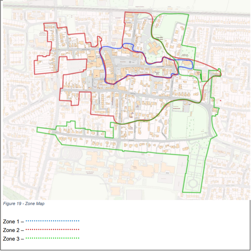
Key to Zone Map
- Blue dots: Zone 1
- Red dots: Zone 2
- Green dots: Zone 3
5.2.4 Building Materials and Local Details
Walls of traditional buildings in Bingham are predominantly un-rendered red brick, with Flemish bond being common in the older buildings, although there are also examples of English bond and one example of header bond at the early 18th century Grade 2 Listed Manor House on the Market Place (see Figure 20).
There is evidence that Bingham had its own brickworks from at least the late 17th century, and this would give rise to bricks being of a similar colour and size. There are some good examples of patterns being created by using different shades of brick. The roofs are predominantly clay pantiles (particularly in the case of former farm buildings) and Welsh slate with a small number of plain-tile roofs. Thatched roofs would also have been used and although these have been replaced with other materials, the steeply pitched roofs which would have been needed to ensure adequate water run-off are clues to their former usage.
Where original or traditional windows survive, they are predominantly timber vertically sliding sashes, often creating a symmetrical façade and having slim glazing bars. A number of Victorian homes in Long Acre and The Banks still retain these original windows, much to the benefit of the appearance of the Conservation Area.
The use of margin lights was popular in the late 19th century, and a number of Victorian houses still retain these. There are many examples of stone lintels, often with a chamfered design, or brick lintels using a slightly arched row of brickwork, often using blue bricks to create a pattern. There are a number of good examples of Georgian doorways with original fan lights above.
5.2.5 Key Characteristics SWOT Analysis
The results within the SWOT Analysis were received from Bingham Town Council on 21st November 2022.
Strengths – what is it about most existing buildings that looks good?
Weaknesses - what is it about most existing buildings that does not look good?
The listed building known as the old Manor House, 22 Market Place, is falling into disrepair and impacting the character of the Market Place.
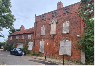
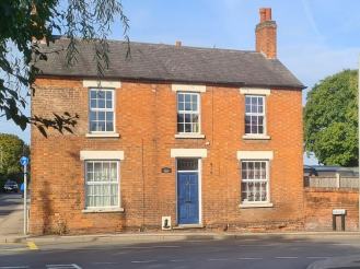
The Grade 2 listed Manor House sits at the north-east corner of the Market Place. Built around the 1700s, it is the only building in the town with entirely header-bonded brickwork to the front elevation.
Manor house is early and mid-18th with 19th century alterations. Red brick with gabled roof with an eaves band and parapet. A central pilaster brings focus to a rendered, bowed panel topped with a half round hood on dentil terracotta brackets.
Opportunities - what could make existing buildings (or new builds) look good and contribute to the character of the area?
- None listed
Threats - what could make existing buildings (or new builds) look worse and detract from the character of the area?
- None listed
5.3 Listed buildings
Buildings on the Government’s List of Buildings of Special Architectural or Historic Interest are called “Listed” buildings and are protected by law. Consent is required from Rushcliffe Borough Council before any works of alteration, extension, or demolition can be carried out on any listed building.
Further information can be found in Rushcliffe Borough Council’s publication Listed Buildings in Rushcliffe.
The complete and up-to-date list of the Secretary of State’s Statutory List of Buildings of Special Architectural Interest or Historic Interest can be found on the Historic England website.
There are 26 listed buildings or structures in Bingham, all Grade 2 apart from the Church which is Grade 1. Many of these are situated in or around Market Place and along Long Acre. All Listed Buildings are shown on the Townscape Appraisal plan, but some smaller structures such as gravestones may not be shown. Names and photos of the Listed Buildings and structures in Bingham Conservation Area (correct as of December 2022) are detailed in Appendix 1.
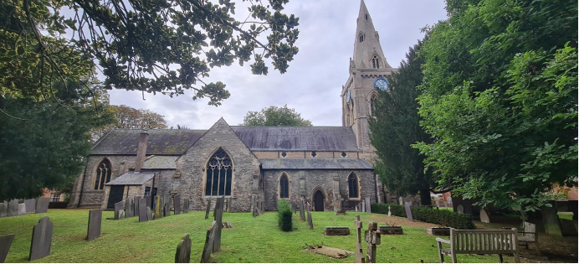
The Grade 1 listed St Mary and All Saints Church. Construction of the church probably began in the 13th century, although the existence of a Norman font suggests an earlier church once stood on the site. The church has seen alteration and restoration over the centuries, particularly during the 19th century.
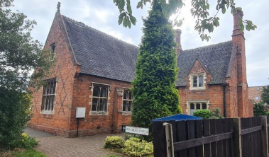
1845 Gothic revival, brick church school and teacher’s house. Coloured brick patterns (diaper work) to gable ends. Roof is plain and patterned tile with coped gables and kneelers, terracotta finials and crosses.
Early 19th with mid-19th century extensions. Two storey, red brick with pantile roof. Off-centre entrances with glazed fan lights to Needham Street. Above the door is glazing bar sash windows to the first floor which sit within a round headed arch.
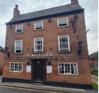
A late 18th century, 3 storey, brick public house with L-shape plan. Front elevation has 3 bays. Two Yorkshire (side sliding) sash windows flank the entrance on the ground floor. Each bay on the top two floors has a sash window. Slate roof and dentil eaves.
Adjoining converted stable block which contributes to the L-shaped plan of the public house. Single and two storey, brick with pantile roof.
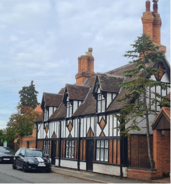
Two late 17th century timber framed farmhouses with 19th century half-timber additions to street façade. Red brick with herringbone brick and render infill. Single storey with attics, and 3 gabled dormers.
5.4 Key Unlisted Buildings
Contribution to the established character of the place can also come from buildings which are not recognised via listing, or are not old. Below are a select number of key examples of positive contributions. A plan with all of the positive contributions to the area can be found in Appendix 1 – Listed Buildings (as of December 2022).
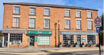
Late 19th century brick in Flemish bond. Three storey with shop fronts to the ground floor with multi-pane pane windows. Residential to the upper two storey. Painted timber sash windows, with plain lintels.
Terrace hard against the foot path. Two storey brick and painted brick. Orange/red pantile roof with the odd slate roof. Segmental arch brick lintels to ground floor windows. A mixture of windows but all with multiple panes.
Early 20th century three bay, two storey house, detached house. Gable roof with single ridge stack. Kirkland house is thought to stand in the cemetery and perhaps even the site of the lord of the manor’s private chapel. For more information see Bingham Heritage Trails Association website.
Two storey, three house terrace. Brick with Flemish bond to the front elevation. Segmented arch lintels to ground and first floor multi-pane windows. Wooden gabled hood to each front door. Three ridge stacks maintain the rhythm of the front elevation.
Brick, semidetached Victorian commuter housing. Two storeys. Arch topped front doors paired together. Hipped roof to canted (angled) bay windows. Many still have 4 pane sash windows with horn. Shaped stone lintels and a band of blue brick to first floor. Margin lights to first floor sash windows.
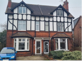
Victorian semidetached commuter housing. Brick, render with mock exposed timber framing. Canted (angled) bay windows. Terracotta moulding. Barge boards to gabled dormer windows.
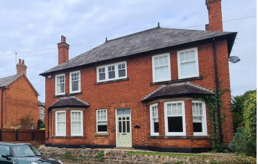
Detached two storey, brick house. Hipped roof with slate tile. Hipped roof to angled bay window. Six panes to upper sash and single pane to lower sash. Wooden panelled door with glazing and rectilinear fanlight.
6 Generic Management Plan for Conservation Areas in Rushcliffe
6.1 Introduction
In carrying out its planning functions, the Borough Council is required in law to give special attention to the desirability of preserving or enhancing the character or appearance of Conservation Areas. The Management Plan for a Conservation Area is a tool to ensure the special character of the area is preserved and enhanced. The management plans aim to:
- Outline a strategic management proposal for the preservation and enhancement of the Bingham Conservation Area.
- Act as a guide for professionals and residents alike regarding:
- features of value, worthy of preservation;
- characteristics worthy of preservation;
- opportunities for enhancement;
- development proposals which preserve and enhance the special character of the area.
- Inspire community commitment to conservation principles and reporting.
6.2 National and Local Policies and Guidance
There is a duty to formulate and publish management plans setting out policies and proposals for the preservation and enhancement of Conservation Areas. Many of these policies and proposals are common to all Conservation Areas, and these are set out in this document. The Central Government Guidance and Local policies applicable to Conservation Areas include:
- Rushcliffe Local Plan Part 1: Core Strategy, with a specific focus on:
- Design and Enhancing Local Identity [in part]
- Historic Environment
- Rushcliffe Local Plan Part 2: Development Policies, with a specific focus on:
- Conserving and Enhancing Heritage Assets
- Development Affecting Archaeological Sites
- The National Planning Policy Framework (NPPF), particularly, but not exclusively the chapter on Conserving and Enhancing the Historic Environment.
- The National Planning Practice Guidance (NPPG) (updated 2021 and subject to continual review)
- By Design: Urban Design in the Planning System – Towards Better Practice (2000)
- The Planning (Listed Buildings and Conservation Areas) Act 1990
- Historic England “Historic England Advice Note 1: Conservation Area Designation, Appraisal and Management”
The council will utilise the full range of strategic policy and guidance documents to ensure that development in Bingham Conservation Area is of a standard that enhances the amenity of the local area. The council will always look to use the most up to date versions of the document.
Supplementary documents may be issued for individual Conservation Areas where specific policies or proposals are needed.
6.3 Article 4 Directions
There are extra consents required in Conservation Areas. For example, in addition to the general control of development, you will
need to get permission for
- Any additions or alterations to the roof (for example, dormer windows)
- The installation of satellite dishes on chimneys, roofs or walls fronting a highway
- Any extension which extends beyond the side of the original dwelling house
- Any extension of more than one storey that extends beyond the rear wall of the original dwelling house
- Cladding the exterior of the dwelling any demolishing of a building or part of a building that has a volume over 115 cubic metres.
Article 4 of the Town and Country Planning (General Permitted Development) Order 1995, allows planning authorities to restrict some permitted development rights within particular areas. This does not necessarily prevent development or change taking place but enables the Local Authority to manage the design and detailing of the works, and potentially grant permission subject to appropriate conditions. The use of Article 4 Directions will be proposed where it is considered appropriate following the completion of each Area Appraisal across the Borough.
Details of Article 4 Directions for Bingham Conservation Area. There are currently no Article 4 Directions for Bingham Conservation Area.
6.4 Building Design
Mimicking the local vernacular is not the only way to ‘fit in’ with the character of a conservation area. National policy makes clear that contemporary designed, provided it is sympathetically designed, cannot be dismissed as an option. Therefore, good contemporary design will be encouraged where it respects the context’s character, scale and massing. This must be demonstrated in the Design and Access Statement submitted with any planning application.
Extensions to buildings in Conservation Areas should respect:
- The key characteristics of the original building, including scale, mass, materials and proportions
- The contextual setting and character of the Conservation Area
Copying like for like can devalue and destroy the ability to “read” historic change, and dilutes our historic heritage. Pastiche designs, incorporating poor imitations of other styles, will be resisted, particularly where they incorporate details which are not locally appropriate. Careful high-quality replication may be required in a few very sensitive locations.
In particularly sensitive locations, such as uniform terraces, exact replication may be necessary to maintain compositional unity. In that case, attention to details, choice of materials and high-quality workmanship are the keynotes. However, in some cases, a direct relationship is not impossible. For example, Flemish Bond brickwork cannot be replicated in cavity walls, and narrow lime mortar joints cannot be replicated in modern metric brickwork.
Where a new building is appropriate, on infill sites or where an existing building detracts from the character of the area, the opportunity should be taken to re-establish the streetscape, reinforce enclosure, open up distant vistas or views of landmarks or hide unsightly views.
“New and old buildings can coexist happily without disguising one as the other, if the design of the new is a response to urban design objectives” (DETR – “By Design”, p19).
As with extensions, good contemporary design which respects local character, and the context of the site will be encouraged.
All new buildings should respond appropriately to the existing frontage and normally follow the established building line. Development or redevelopment will normally be resisted if:
“it blocks important views identified in the individual appraisals, uses important open spaces identified in the appraisals, adversely affects the setting of any Listed or key buildings, fails to maintain or re-establish the streetscape where appropriate dominates its Conservation Area background fails to recognise the context of the site destroys important features identified in the individual appraisals such as boundary walls, fences, hedgerows or trees”
Where the quantity of contemporary schemes in a small area becomes significant and outnumbers older buildings within the area, further contemporary schemes could fundamentally shift the architectural character of the area and thus be harmful, even if well designed as an individual project.
New development that stands out from the background of buildings may be appropriate in exceptional circumstances if it contributes positively as a landmark to enhance the street scene, to highlight a corner or to signal a visual change of direction such as along a curving vista.
Any external lighting should be carefully designed and sited to minimise light pollution.
Energy producing or saving devices are generally welcomed by the Council, but careful consideration is required when these are to be located in a Conservation Area and some may require planning permission. In particular, they should be positioned to minimise their impact on the building and on the local amenity.
6.5 Publicity and Knowledge Transfer
Ambiguity about additional controls within a Conservation Area raises the likelihood of inappropriate developments occurring which
may damage the integrity of the conservation area designations.
Efforts have been made to engage local community groups in the development and review of the character appraisals. Empowering
communities to define the special architectural and historic interest of the Conservation Area aims to raise awareness.
Whether the appraisal took a community-led or a council-led approach, upon reviewing all Conservation Areas, the public were invited to ask questions and comment during a public consultation. A consultation event also aimed to diminish any ambiguity about
restrictions within a Conservation Area and increase the likelihood of sensitive and appropriate developments, maintaining the character
of the area.
The council recognise the potential issues of turnover in residency and ownership of properties in the conservation area. Therefore,
Rushcliffe Borough Council will periodically use their media outlets to highlight conservation area designations and the significant,
related planning controls.
The date of the Consultation Event 25/03/2023
If there are any queries about conservation areas, please email conservationareas@rushcliffe.gov.uk
6.6 Public Realm
General maintenance and upkeep to the public realm may include fixing damage to roads and pavements, and fixing issues with street lighting. Issues such as these can impact the quality of the Conservation Area.
The council aims to encourage works to the public realm that are in keeping with, or actively enhance the conservation area. Rushcliffe Borough Council can only advise on work within the public realm that does not require planning permission (for example work completed by statutory undertakers, such as the Highways Authority). In these instances, Rushcliffe borough council cannot prevent such work.
Nottinghamshire County Council are responsible for repairs to roads, pavements and street lighting.
Report issues of repairs to roads, pavements and street lighting to Nottinghamshire County Council online.
Rushcliffe Borough Council will continue to undertake their duties in maintaining the public realm. Vandalism, fly tipping and street cleaning are all the responsibility of Rushcliffe Borough Council. Report issues to Rushcliffe Borough Council online.
Standard notification forms (a section 211 notice) - further information and contact details.
A flow chart of the decision-making process regarding works to trees.
6.7 Boundary Treatments
Where there is a proposal for a new boundary treatment to be installed, the council would encourage the use of boundary treatments within the area.
Within conservation areas, planning permission is required to alter, maintain, improve, take down or build any new gate, fence, wall or other enclosure with:
- A height of one metre or more if next to a highway (including a public footpath or bridleway), waterway or open space; or
- A height of two metres or more elsewhere.
Where planning permission is required to remove a wall, Rushcliffe Borough Council will aim to protect those boundary walls and fences that have been identified as positively contributing to the area.
Hedgerows are significant habitats for wildlife in lowland Britain. Regulations are intended to protect important hedges in the countryside. The policy applies to hedges that are more than 20 metres long, (or less if connected to another hedge) on or adjacent to:
- Land used for agriculture or forestry, including the keeping of horses or donkeys
- Registered common land and village greens
- Local Nature Reserves and Sites of Special Scientific Interest.
The policy does not apply if the hedge is within or on the boundary of the curtilage of a house.
6.8 Buildings at risk
A few of the important buildings across the various Conservation Areas are currently vacant or not in regular use, which may lead to some being “at risk” of neglect or decay.
The Council will encourage and advise on renovation and repair work that is sensitive to the original or traditional historic character of the building and retains original features. The council will monitor the opportunity and potential for grant aid schemes to encourage the basic maintenance work necessary to ensure that key buildings within the conservation area are structurally sound and weather tight. However, given the current financial climate and outlook, such schemes are unlikely in the short to medium term.
There is a presumption against the demolition of buildings which contribute to the character of the area unless there are exceptional circumstances. It would benefit both the physical form and the function of the Conservation Area if these buildings were repaired, maintained and brought back into use.
Where the poor condition of a building or structure is as a result of neglect and lack of maintenance by its owner there is no requirement for the Borough Council to take its deteriorated condition into account when deciding whether demolition is appropriate. This is to avoid rewarding the deliberate neglect of buildings by representing such action as a way to obtain planning permission for demolition and redevelopment.
6.9 Enforcement
Rushcliffe Borough Council will, from time to time, assess and monitor changes in the appearance and condition of Bingham Conservation Area. This will ensure that where necessary enforcement action can be taken promptly to deal with problems as they arise.
Where co-operation cannot be gained by any other means, Rushcliffe Borough Council has the ability to use additional enforcement powers to tackle particular issues within conservation areas. The Council may take formal action if the condition of any building (listed or unlisted) which makes a positive contribution to the character of the Conservation Area is considered to be at risk.
The council will work in accordance with their enforcement policy, which aims to provide an efficient enforcement service in support of the Council’s statutory planning service. Rushcliffe Borough Council’s enforcement actions will remain transparent, consistent, and proportionate, as it is recognised that effective controls over unauthorised development assists in conserving the natural and built environment whilst helping to protect the quality of people’s lives and maintaining the Council’s integrity.
7 Appendix 1 – Listed Buildings (as of December 2022)
Grade: 2
Listing entry number: 1244718
National grid reference: SK 70416 39877
Location: 7 Union Street
E W Dixon (Chemists) 7 And 9, Market Street
Grade: 2
Listing entry number: 1370112
National grid reference: SK 70460 39866
Location: 7 And 9, Market Street, NG13 8AB
10 Market Street and 1 Union Street
Grade: 2
Listing entry number: 1273142
National grid reference: SK 70441 39880
Location: No.10, Market Street (Warren and Allen) and Adjoining No. 1 Union Street
Grade: 2
Listing entry number: 1258960
National grid reference: SK 70513 39952
Location: Market Cross, Market Place
2 K6 Telephone Kiosks Outside 18 Market Place, Market Place
Grade: 2
Listing entry number: 1244716
National grid reference: SK 70507 39974
Location: 2 K6 Telephone Kiosks Outside 18 Market Place
Grade: 2
Listing entry number: 1273138
National grid reference: SK 70481 39994
Location: Haden House 18, Market Place, NG13 8AP
Beauvale House And Adjoining Outbuilding
Grade: 2
Listing entry number: 1045665
National grid reference: SK 70472 40003
Location: Beauvale House And Adjoining Outbuilding, Market Place
Number 19 and Adjoining Shop and Boundary Wall
Grade: 2
Listing entry number: 1370111
National grid reference: SK 70542 39975
Location: Number 19 and Adjoining Shop and Boundary Wall, Market Place
Grade: 2
Listing entry number: 1045666
National grid reference: SK 70562 39975
Location: The Manor House, 22, Market Place, NG13 8AP
Number 7 With Adjoining Outbuilding, Boundary Walls and Water Pump
Grade: 2
Listing entry number: 1045659
National grid reference: SK 70648 39947
Location: Number 7 With Adjoining Outbuilding, Boundary Walls and Water Pump, Church Street
Lych Gate, Fence and Boundary Wall at Church Of St Mary and All Saints
Grade: 2
Listing entry number: 1370107
Location: Lych Gate, Fence and Boundary Wall at Church of St Mary and All Saints, Church Street
Church of St Mary and All Saints
Grade: 1
Listing entry number: 1045660
National grid reference: SK 70721 39924
Location: Church of St Mary and All Saints, Church Street
Group of 3 Headstones 10 Metres South West of Tower at Church of St Mary and All Saints
Grade: 2
Listing entry number: 1370108
Location: Group of 3 Headstones 10 Metres South West of Tower at Church of St Mary and All Saints,
Church Street
Group of 3 Headstones 15 Metres South of Choir Vestry at Church of St Mary and All Saints
Grade: 2
Listing entry number: 1045662
National grid reference: SK 70736 39930
Location: Group of 3 Headstones 15 Metres South of Choir Vestry at Church of St Mary and All Saints,
Church Street
Headstone 1.5 Metres South of Choir Vestry at Church of St Mary and All Saints
Grade: 2
Listing entry number: 1045661
National grid reference: SK 70744 39939
Location: Headstone 1.5 Metres South of Choir Vestry at Church of St Mary and All Saints, Church
Street
Pair of Headstones 12 Metres South of Chancel at Church Of St Mary and All Saints
Grade: 2
Listing entry number: 1370109
National grid reference: SK 70758 39938
Location: Pair of Headstones 12 Metres South of Chancel at Church of St Mary and All Saints, Church Street
Grade: 2
Listing entry number: 1258810
National grid reference: SK 70790 39906
Location: Church House (Playschool), East Street
Pigeoncote, Stables and Cow Shed Opposite Porchester Farmhouse
Grade: 2
Listing entry number: 1244712
National grid reference: SK 70744 39782
Location: Pigeoncote, Stables and Cow Shed Opposite Porchester Farmhouse, Long Acre
Numbers 65 And 67 (Gilchrist, Decorators)
Grade: 2
Listing entry number: 1370110
National grid reference: SK 70648 39823
Location: Gilchrist, Decorators, 65 And 67, Long Acre
Listing entry number: 1243824
National grid reference: SK 70641 39821
Location: 61 and 63, Long Acre, NG13 8AG
Listing entry number: 1045664
National grid reference: SK 70982 39706
Location: Summerhouse at Number 16, Long Acre East, NG13 8BY
Number 16 and Adjoining Boundary Wall
Listing entry number: 1243826
National grid reference: SK 71010 39736
Location: Number 16 and Adjoining Boundary Wall, Long Acre East
Listing entry number: 1258957
National grid reference: SK 70435 39802
Location: The Wheatsheaf Inn, Long Acre, NG13 8BG
19 and 21, Long Acre (The Home Made Shop)
Listing entry number: 1045663
Location: The Home Made Shop, 19 and 21, Long Acre
Water Pump at Numbers 19 and 21
Listing entry number: 1273195
Location: Water Pump at Numbers 19 and 21, Long Acre
Brompton House and Attached Walls and Summerhouse
Listing entry number: 1243825
Location: Brompton House and Attached Walls and Summerhouse, Needham Street, NG13 8AE
The titles of these listings may not make it clear that all listed buildings always include all attached structures and extensions, regardless of age, and all detached outbuildings built before 1 June 1948 which are, or were at the time of listing, ancillary to the function of the primary listed building and were in the same ownership at the time of listing.
For example, when a house is listed, the listing will apply to extensions, porches, detached historic stables, barns, wash houses, privies etc. Such outbuildings and extensions are only exempt from the provisions of listing where the listing specifically excludes them.
8 Appendix 2 – Townscape Appraisal
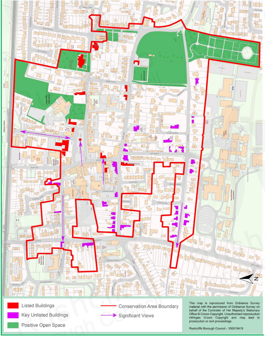
The Bingham Townscape Map above shows:
- Locations of listed buildings
- Locations of key unlisted buildings
- Open space
- Locations of trees, hedges, and significant hedges and fences
- Viewpoints
Conservation Areas
- Bingham Conservation Area
- East Bridgford Conservation Area
- East Leake Conservation Area
- Hawksworth Conservation Area
- Hickling Conservation Area
- Ruddington Conservation Area
- Thoroton Conservation Area
- Wiverton Conservation Area
- Langar Conservation Area
- West Leake Conservation Area
- Whatton in the Vale Conservation Area
- Costock Conservation Area
- Sutton Bonington Conservation Area
- Upper Saxondale Conservation Area
- Wysall Conservation Area
- Bradmore Conservation Area
- Car Colston Conservation Area
- Scarrington Conservation Area
- Orston Conservation Area
- Flintham Conservation Area
- Edwalton Conservation Area
- Aslockton Conservation Area
- Bunny Conservation Area
- Granby Conservation Area
- Keyworth Conservation Area
- Thrumpton Conservation Area
- Normanton on the Wolds Conservation Area
- Upper Broughton Conservation Area
- Screveton Conservation Area
- Kneeton Conservation Area
- Colston Bassett Conservation Area
- Cropwell Bishop Conservation Area