Thrumpton Conservation Area
Thrumpton Conservation Area Appraisal and Management Plan April 2025
Contents
1.1 Conservation Areas
1.2 The Purpose of a Conservation Area Character Appraisal
1.3 The Planning Policy Context
2 Thrumpton Location and Landscape Setting
2.1 The Thrumpton Conservation Area
3.1 Location and Historic Activities
3.2 Archaeology
3.3 Historical Mapping
4.1 Plan, Form and Layout
4.2 Landmarks, Focal Points and Views
4.3 Open Spaces, Trees and Landscape
4.3.1 Open Spaces, Trees, and Landscapes SWOT Analysis
4.4 Public Realm
5 Buildings of the Conservation Area and Key Characteristics
5.1 Building Types and Activity
5.1.1 Building Types and Activity SWOT Analysis
5.2 Key Characteristics and Building Materials
5.2.1 Key Characteristics: Village Core
5.2.2 Key Characteristics: Manor Farm
5.2.3 Key Characteristics: SWOT Analysis
5.3 Listed Buildings
5.4 Key Unlisted Buildings
6.1 Introduction
6.2 National and Local Policies and Guidance
6.3 Article 4 Directions
6.4 Building Design
6.5 Publicity and Knowledge Transfer
6.6 Public Realm
6.7 Boundary Treatments
6.7.1 Walls and Fences
6.7.2 Hedges
6.8 Buildings at risk
6.9 Enforcement
7 Appendix 1 – Listed Buildings (as of January 2025)
8 Appendix 2 – Conservation Area Boundary and Townscape Appraisal Map
1 Introduction
1.1 Conservation Areas
Rushcliffe Borough Council has an obligation under Section 69 of the Planning (Listed Buildings and Conservation Areas) Act 1990 to review, from time to time, its Conservation Area designations.
A Conservation Area, as defined under Section 69, is ‘an area of special architectural or historic interest the character or appearance of which it is desirable to preserve or enhance’.
Thrumpton Conservation Area was designated in 1972. Prior to this reappraisal of April 2025, the Thrumpton Conservation Area was reviewed in March 2010.
Section 71 of the Planning (Listed Buildings and Conservation Areas) Act 1990 highlights the local planning authority’s duty to formulate and publish proposals for the preservation and enhancement of the conservation areas. This document, therefore, aims to identify and
reaffirm (or redefine) the special architectural or historic interest of the area which warrants its designation.
Conservation Area Appraisals are not, and never have been, tools for to fossilise a place against change, instead, the processes of change which allow places to grow and evolve are recognised as being unavoidable, and it is also recognised that change can be a positive and desirable force. The designation instead allows greater scrutiny and control to manage change to positive effect and to ensure that any changes which require planning permission do not harm, and ideally serve to actively enhance, the existing character of the place.
Thrumpton Conservation Area: Summary of Special Interest
Strong ‘estate village’ character.
Large scale open space and positive landscape setting provided by both surrounding environment and the parkland of Thrumpton Hall.
1.2 The Purpose of a Conservation Area Character Appraisal
The purpose of a Conservation Area Character Appraisal is to:
- Identify and record the special interest of the Conservation Area to ensure there is public awareness and understanding of what is
worthy of preservation. - To define and reassess current boundaries to accurately reflect what is now perceived to be of special interest.
- To identify opportunities to safeguard and enhance the special interest of the Conservation Area.
It should be noted that the content in this document is not a comprehensive account of every significant building, structure, tree, wall, feature, or space. Therefore, any omission should not be assumed to imply that they are of no interest.
Generally, the character and appearance of a Conservation Area will be preserved or enhanced by:
- Providing controls and regulating development through the planning system.
- Applying the extra controls that designation provides over demolition, minor development, and the protection of trees.
- Environmental enhancement schemes and possibly providing financial assistance for the repair and restoration of specific buildings.
- Encouraging public bodies such as the local highways authority or utility companies to take opportunities to improve the street scene through the appropriate design and sensitive sighting of street furniture (and retention of historic features of interest), or the removal of eyesores and street features that have a negative impact such as overhead wires.
Thrumpton Conservation Area: Summary of Key Issues
- Decline of farming within the village removes an element of character and activity, as well as leaving some former agricultural
yards vacant or under-used.
1.3 The Planning Policy Context
This appraisal provides a firm basis on which applications for development within the Thrumpton Conservation Area would be
assessed. It should be read alongside the wider development plan policy framework produced by Rushcliffe Borough Council and other
National Planning Policy Guidance documents. The relevant documents include:
- Rushcliffe Local Plan Part 1: Core Strategy, with a specific focus on:
- Policy 10 (Design and Enhancing Local Identity) [in part]
- Policy 11 (Historic Environment)
- Rushcliffe Local Plan Part 2: Development Policies, with a specific focus on:
- Policy 28 (Conserving and Enhancing Heritage Assets)
- Policy 29 (Development Affecting Archaeological Sites)
- The National Planning Policy Framework (NPPF) (Revised -2021)
- The National Planning Practice Guidance (2015 - Subject to Continual Review)
- By Design: Urban Design in the Planning System – Towards Better Practice (2000)
- The Planning (Listed Buildings and Conservation Areas) Act 1990
2 Thrumpton Location and Landscape Setting
Rushcliffe Borough forms the southern tip of Nottinghamshire, which borders Leicestershire. It is predominantly a rural Borough that contains a mixture of city suburbs, market towns and villages. Rushcliffe is located about half a mile South of Nottingham city centre, with the River Trent forming the majority of its northern boundary and the River Soar defining its western boundary.
The A46 (Fosse Way), a distinctive Roman Road, runs through the centre of the Borough and leads to Newark in the North and Leicester in the South. In the northern half of the Borough, the A52 forms Nottingham’s primary transport link to Grantham and the East of England. Junction 24 of the M1 and East Midlands Airport are located about 1 mile from the western border.
The village of Thrumpton is situated close to the western border of Rushcliffe Borough approximately 3 miles along the A453 from Junction 24 of the M1 and 1 mile to the east of the Midland mainline railway. The River Trent flows directly to the north of the village centre and has shaped the surrounding landscape of predominantly flat arable farm land. To the south, the wooded Wrights Hill lessens the visual impact of the now decommissioned coal fired Ratcliffe-on-Soar power station which is situated ½ mile away.

2.1 The Thrumpton Conservation Area
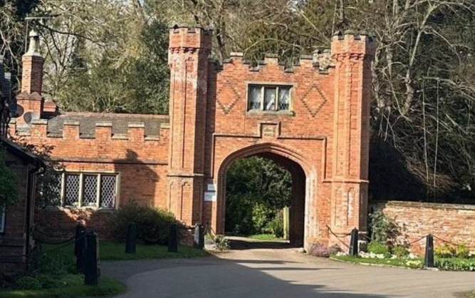
The boundary of this large Conservation Area includes all the built-up area of the village together with the historic parkland of Thrumpton Hall. Originally designated in 1972, it includes 19 Listed Buildings or structures. Against a backdrop of high trees, the old village and street is predominantly fronted by hedges on one side and walls, cottages and some farm out-buildings on the other; All Saints’ Church and The Gate House to Thrumpton Hall marking the two ends.
During the 2025 review, the conservation area boundary was extended to include the site of the former ferry crossing due to its historical significance. Although physical remnants of the crossing remain, they are currently obscured by vegetation.
- Conservation Area Boundary covers: 137 hectares (approximate)
- Number of Grade 1 listed buildings: 0
- Number of Grade 2* listed buildings: 0
- Number of Grade 2 listed buildings: 10
A full list of Thrumpton Conservation Area’s Listed buildings can be found in Appendix 1.
3 Historical Contexts
3.1 Location and Historic Activities
Originally called Turmodeston, the village of Thrumpton is thought to have started life as a Viking farmstead.
The village was mentioned in the Domesday Book of 1086 and throughout the medieval period, Turmodeston developed into a collection of huts and rustic farmhouses situated in what is now the parkland of Thrumpton Hall.
During the reign of Henry II (1154-1189) Nottingham was granted a charter allowing it to exact tolls on River Trent shipping between Thrumpton and Newark, the village being selected for its position close to the county border. Later Thrumpton also became a river crossing with the installation of a ferry to the north east of the village run by the occupants of Ferry Farm. The ferry crossing was still shown on early OS maps into the mid 20th Century, it did not survive long after the end of the Second World War and the closure of the plaster mill which was based nearby.
The present Thrumpton Hall dates from 1607 but incorporates elements of an earlier manor house. A priest’s hole at the foot of a secret staircase built into the thickness of a chimney breast survives from the earliest house and was used by the Roman Catholic Powdrill family to conceal Father Garnett, a leading figure in the 1605 Gunpowder Plot. The Powdrill’s involvement in the affair eventually led to the confiscation of their estate which was passed to the Pigot family. The new owners carried out lavish and extensive alterations to the Hall during the 1660s including the addition of a magnificent carved wooden staircase. The expense incurred by these improvements eventually resulted in Gervase Pigot II (to whom there is a monument at All Saints Church dated 1669) being forced to mortgage the estate, and in 1694 John Emmerton foreclosed it and took possession. Soon after, Emmerton enclosed the park, clearing the buildings of the original village and building a new group of houses around the existing church of All Saints.
He also carried out extensive tree planting in the grounds of the Hall. The footprint of these buildings and traces of medieval ridge and furrow farming are still visible in aerial photographs of the park. Many houses in the village feature diamond shaped date-stones John Emmerton’s descendant, Lucy Emmerton Westcomb (Lady Byron) ruled over the village for 68 years until her death in 1912 and dominated its affairs. As a rule she would only employ good singers and consequently Thrumpton’s famous village choir regularly sang at Southwell Minster during the 19th century. She had All Saints church restored at a cost of several thousand pounds and had the schoolhouse and two new farmhouses built in the village. She also forbade the opening of a public house at Ferry Farm and to this day Thrumpton does not have one.
During the 20th century the village itself has seen steady growth in the form of new houses and agricultural buildings but the wider setting has been altered over time by infrastructure projects such as the 18th century Cranfleet Canal which bypasses a shallow section of the River Trent, the 19th century Redhill Tunnel of the Midland Railway which bores under part of the Thrumpton estate to the west of the village, and the 1960s Ratcliffe-on-Soar power station which dominates the skyline to the south of the village. Now decommissioned the power station is likely to be replaced through development as part of a Local Development Order enacted in 2024.
3.2 Archaeology
Archaeological evidence in the form of a Neolithic polished axe head suggests that the site of the village, in its position close to the important trade route of the River Trent, has been the scene of human activity since pre-history.
There have also been finds of iron age and roman pottery within the village in the vicinity of the old ferry landing at the north-eastern end of the village
There are also a number of groups of earthwork features to the northeast of the village, these have been identified from aerial photography and ground survey but their condition is poor making it difficult to determine their nature or age, these features have not been excavated.
There are some reminders of more recent industrial activity around the village, curving field boundaries to the north-east mark the route of a 19th century tramway which transported gypsum from mines at Cottagers Hill and Gotham Hill to a plaster mill on the banks of the Trent to the east of Ferry Farm.
3.3 Historical Mapping


4 Spatial Analysis
The relationship between open spaces and the built form within a conservation area can be central to its character. This section describes the village’s layout, highlighting the significant views, landmarks and historical focal points. The contribution of open green spaces, trees and other natural elements to the conservation area’s character is also described within this section.
4.1 Plan, Form and Layout
Below is a map that describes the current plan, form and layout of the village/town.
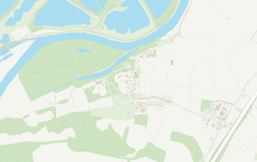
This map is reproduced from Ordnance Survey material with the permission of Ordnance Survey on behalf of the Controller of His Majesty’s Stationary Office © Crown Copyright. Unauthorised reproduction infringes Crown Copyright and may lead to prosecution or civil proceedings.
Rushcliffe Borough Council - 100019419
4.2 Landmarks, Focal Points and Views
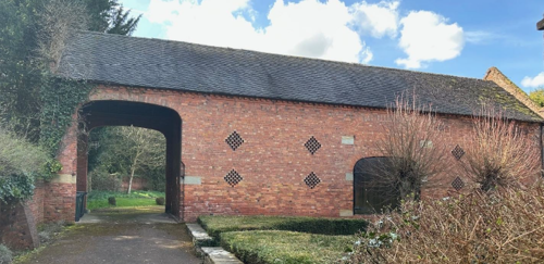
The most prominent landmarks in the village are All Saints church, Thrumpton Hall and Thrumpton Hall’s gatehouse.
The church and gatehouse in their positions at either end of the old village street are striking focal points and close the views in either direction.
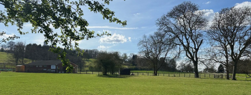
landscape from within the village, perhaps the best is towards the
parkland of Thrumpton Hall across the cricket pitch
In the eastern half of the Conservation Area there are frequent views over open countryside and along the tree and hedge lined Church Lane and Barton Lane. In the centre of the village, views are more restricted due to the enclosure created by mature trees and boundary walls, although there are still glimpses out into the landscape through paddocks at the rear of properties.
From the Cricket Ground however there are fine views over Thrumpton Hall’s parkland, including glimpses of the Hall itself. The Townscape Appraisal map illustrates these key views and other views which link the village to the adjacent countryside.
4.3 Open Spaces, Trees and Landscape
The eastern half of the Conservation Area is dominated by agricultural activity and arable fields but there are also a number of attractive private gardens and paddocks. Along with the hedgerows which line Barton Lane these spaces create a distinctly rural approach to the village.
The stretch of Church Lane leading into the old part of the village is lined with mature trees, grass banks and hedgerows. In the old part of the village the churchyard stands out as the most accessible open space as many private gardens are encircled by brick or stone boundary walls. This part of the Conservation Area is dominated by groups of mature trees.
The grounds and gardens of Thrumpton Hall to the west create the largest open space in the village and lead to an area of open parkland beyond the boundary of the Conservation Area. The most significant trees, hedges, open spaces, grass verges and gardens are marked on the Townscape Appraisal map.
4.3.1 Open Spaces, Trees and Landscape SWOT Analysis
Strengths - what are the positives of the open spaces, trees, and landscape
- Strong positive landscape character provided through Thurmpton Halls associated parkland.
- Good visual links into surrounding agricultural and rural landscape.
- Extensive tree planting and rural soft boundaries throughout the conservation area.
Weaknesses - what are the negatives of the open spaces, trees, and landscape
- Impact of visible chimney tower from nearby Radcliffe on Soar power station.
- Much tree planting in the core of the village is mature with limited succession planting.
Opportunities – what could make the open spaces, trees, and landscape better?
- Redevelopment of the former power station site and removal of the chimney as the tallest single feature.
Threats - what would make an open spaces, trees and landscape worse?
- Redevelopment of the former power station site.
Works to Trees
You must contact the Local Planning Authority (LPA), Rushcliffe Borough Council before any works (cutting OR pruning) are carried out to trees within the Thrumpton Conservation Area.
Six weeks’ notice is required before any works to trees within the Conservation Area is carried out, even if they are not protected by a Tree Preservation Order (TPO).
If there is a tree which undergoes annual maintenance, include this information with the notice. It may be possible, upon agreement with the tree officer, that only one notice is required to cover the future annual maintenance.
Standard notification forms (a section 211 notice), further information and contact details.
A flow chart of the decision-making process regarding works to trees.
4.4 Public Realm
Barton Lane and the eastern stretch of Church Lane retain a rural character in terms of boundary treatments (hedges, grass banks and treelines) but in the centre of the village properties make use of roughly cut stone and brick boundary walls, chain linked bollards and picket fences. Roads are paved with asphalt throughout and there are few footpaths. Private drives are generally of gravel.
5 Buildings of the Conservation Area and Key Characteristics
5.1 Building Types and Activity
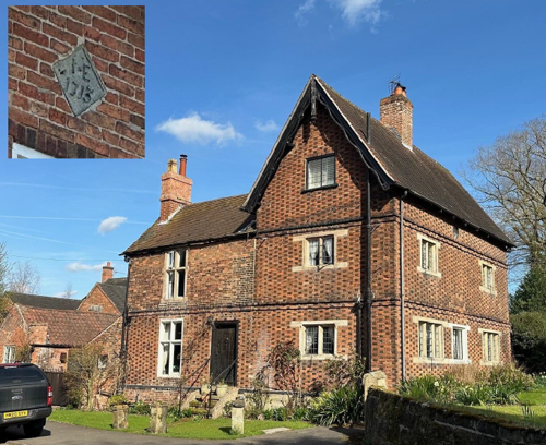
The older buildings in Thrumpton are a mixture of period farmhouses, cottages, outbuildings and barns, many of which can be seen on the historical maps included within this appraisal. Amongst them are examples of the local red brick cottages which feature early 1700’s datestones and the initials of John Emmerton. Whilst most of these are well built modest cottages the former rectory adjacent All Saints Church is of a similar period and style but on a larger 3 storey scale, unlike other examples where the datestone tends to be on the street frontage that on the former rectory is at the rear, visible from within the churchyard.
houses from the early 1700’s, unusually its datestone is at the rear
The obvious exceptions to this are the medieval church of All Saints and the ornate architecture and grand scale of Thrumpton Hall.
Manor Farm represents a second focus for the village, some 500 metres east from the historic fringe of the village proper, much of that intervening space has been gradually infilled with development during the 20th century, however ‘New Buildings’ likely date to around the 1860’s being a fine row of cottages symmetrically arranged along Church Lane, with a further pair of blocks of cottages arranged set back at each end of the row to form a bracketed arrangement. Like the early 1700’s cottages their construction features polychrome brickwork, although the impact is lessened by a few of the properties having had their brickwork painted.
Aside from the clear influence of the estate farming is also a clear influence on the character of the village, with Manor Farm, Wood Farm, Church Farm, Thrumpton House and Farry Farm all still recognisable, although most have since ceased to operate as farms.
Some of the farms feature some interesting architectural elements, for example a highly unusual threshing barn at Thrumpton House with a covered through passage located immediately at one end of the building. There is nothing to suggest that the building was once longer and the archway over the full height through passage must place incredible loads onto the gable end, yet there is little obvious purpose for this part of the building.
against its western gable
Remnants of industrial activity are limited and now rather subtle, these are described in the archaeology section (3.2).
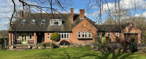
The Conservation Area also includes a variety of more modern construction, including functional agricultural buildings and 20th century residential development. Some notable examples of this more recent development include the 1956 Manor Lodge which is a well designed domestic revival style bungalow which is relatively unaltered as seen from the street, and its neighbour the replacement Manor Farmhouse which is a reasonably successful neo Georgian design of the late 1940’s.
are a number of high quality examples
5.1.1 Building Types Activity and SWOT Analysis
Strengths - what activities/places exist that makes the village/town great?
- Large number of early/mid 18th century estate cottages of consistent materials and character.
- Some good quality 20th Century additions, including some with unusual designs.
Weaknesses - what activities/places exist that detract from making the village/town great?
- Some areas looking dilapidated, particularly some under-utilised former agricultural sites.
Opportunities - what activities/places could exist that would village/town even better?
- Whilst the departure of farming is a threat where sites are sat vacant and farming is unlikely to reoccupy them redevelopment could represent an opportunity.
Threats - what activities/places would make village/town worse?
- Departure of agricultural uses altering the character of the place.
5.2 Key Characteristics and Building Materials
The village core is focused on the parish church and Thrumpton Hall, it features some of the oldest properties in the village together with several of its farms, there is also some mid 20th century development towards the south east infilling the space between this area and the originally slightly remote cottages at New Buildings.
5.2.1 Key Characteristics: Village Core
Materials:
Walls: Soft Red Brick with some brunt brick decoration.
Roofs: Local slate to diminishing courses, plain tile, some older properties feature timber barge boards to gables.
Windows: Largely timber casements divided into 3 or 6 panes.
Doors: Timber planked on older properties
Key Characteristics / Architectural Features:
Decorative timber barge boards on some older properties, fairly unusual in the area. Projecting parapet walls Decorative polychrome brickwork Datestones on older properties.

ones, are not a common feature in Rushcliffe, however there are
several examples in Thrumpton
5.2.2 Key Characteristics: Manor Farm
There is a secondary focus of development at the junction of Church Lane and Barton Lane, near Manor Farm, this areas is dominated by Manor and Wood Farms, as well as the more outlying Fields Farm to the north. The area also features an outlying estate cottage at Southern Cottage. Barn conversions and some reasonably high quality mid 20th century dwellings complete this character zone.
Materials:
Walls: Mix of later red brick, some render and even isolated use of cladding.
Roofs: Concrete tile, slate and plain tile.
Windows: uPVC and timber, heavier.
Doors: Timber and composite materials, often with elements of glazing.
Key Characteristics / Architectural Features:
Datestones on both older properties but also on some more modern examples, picking up on the locally distinctive feature.
Some concerted agricultural complexes which retain agricultural character, with elements of new build/replacement.
5.2.3 Key Characteristics SWOT Analysis
Strengths – what is good about most existing buildings that looks good?
- Some high quality mid-20th century additions, including some unusual designs such as at Manor Lodge and 59 Church Lane.
- Survival of estate cottages, most of which are little altered or have been enlarged with a degree of sensitivity.
Weaknesses – what is about most existing buildings that does not look so good?
- Some areas looking dilapidated, particularly some under-utilised former agricultural sites.
- Survival of estate cottages, most of which are little altered or have been enlarged with a degree of sensitivity.
Opportunities – what could make existing buildings (or new builds) look good and contribute to the character of the area?
- Whilst the departure of farming is a threat where sites are sat vacant and farming is unlikely to reoccupy them redevelopment could represent an opportunity.
Threats – what could make existing buildings (or new builds) look worse and detract from the character of the area?
- Decline of agricultural use of former farm buildings, particularly those less readily capable of being converted, leaves underutilised sites.
- Rendering of brick properties, particularly those which are not detached or which feature polychrome decoration.
5.3 Listed Buildings
Buildings on the Government’s List of Buildings of Special Architectural or Historic Interest are called “Listed” buildings and are protected by law. Consent is required from Rushcliffe Borough Council before any works of alteration, extension, or demolition can be carried out on any listed building.
Further information can be found in Rushcliffe Borough Council’s publication Listed Buildings in Rushcliffe.
The complete list of the Secretary of State’s Statutory List of Buildings of Special Architectural Interest or Historic Interest can be accessed online.
Names and details of the Listed Buildings and structures in Thrumpton Conservation Area (correct as of January 2024) are detailed in Appendix 1. All Listed Buildings are shown on the Townscape Appraisal plan, but some smaller structures such as gravestones may not be shown.
5.4 Key Unlisted Buildings
Contribution to the established character of the place can also come from buildings which are not recognised via listing, or are not old. A plan with all of the positive contributions to the area can be found in Appendix 2 - Conservation Area Boundary and Townscape Appraisal Map.
6 Generic Management Plan for Conservation Areas in Rushcliffe
6.1 Introduction
In carrying out its planning functions, the Borough Council is required in law to give special attention to the desirability of preserving or enhancing the character or appearance of Conservation Areas. The Management Plan for a Conservation Area is a tool to ensure the special character of the area is preserved and enhanced. The management plans aim to:
- Outline a strategic management proposal for the preservation and enhancement of the Thrumpton Conservation Area.
- Act as a guide for professionals and residents alike regarding:
- features of value, worthy of preservation;
- characteristics worthy of preservation;
- opportunities for enhancement;
- development proposals which preserve and enhance the special character of the area.
- Inspire community commitment to conservation principles and reporting.
6.2 National and Local Policies and Guidance
There is a duty to formulate and publish management plans setting out policies and proposals for the preservation and enhancement of Conservation Areas. Many of these policies and proposals are common to all Conservation Areas, and these are set out in this document. The Central Government Guidance and Local policies applicable to Conservation Areas include:
- Rushcliffe Local Plan Part 1: Core Strategy, with a specific focus on:
- Design and Enhancing Local Identity [in part]
- Historic Environment
- Rushcliffe Local Plan Part 2: Development Policies, with a specific focus on:
- Conserving and Enhancing Heritage Assets
- Development Affecting Archaeological Sites
- The National Planning Policy Framework (NPPF), particularly, but not exclusively the chapter on Conserving and Enhancing the Historic Environment.
- The National Planning Practice Guidance (NPPG) (updated 2021 and subject to continual review)
- By Design: Urban Design in the Planning System – Towards Better Practice (2000)
- The Planning (Listed Buildings and Conservation Areas) Act 1990
- Historic England “Historic England Advice Note 1: Conservation Area Designation, Appraisal and Management”
The council will utilise the full range of strategic policy and guidance documents to ensure that development in Thrumpton Conservation Area is of a standard that enhances the amenity of the local area. The council will always look to use the most up-to-date versions of the document.
Supplementary documents may be issued for individual Conservation Areas where specific policies or proposals are needed.
6.3 Article 4 Directions
There are extra consents required in Conservation Areas. For example, in addition to the general control of development, you will
need to get permission for
- Any additions or alterations to the roof (for example, dormer windows)
- The installation of satellite dishes on chimneys, roofs or walls fronting a highway
- Any extension which extends beyond the side of the original dwelling house
- Any extension of more than one storey that extends beyond the rear wall of the original dwelling house
- Cladding the exterior of the dwelling
- Any demolishing of a building or part of a building that has a volume over 115 cubic metres
Article 4 of the Town and Country Planning (General Permitted Development) Order 1995, allows planning authorities to restrict
some permitted development rights within particular areas. This does not necessarily prevent development or change taking place
but enables the Local Authority to manage the design and detailing of the works, and potentially grant permission subject to appropriate conditions. The use of Article 4 Directions will be proposed where it is considered appropriate following the completion of each Area Appraisal across the Borough.
Details of Article 4 Directions for Thrumpton Conservation Area
There are currently no Article 4 Directions for Thrumpton Conservation Area.
6.4 Building Design
Mimicking the local vernacular is not the only way to ‘fit in’ with the character of a conservation area. National policy makes clear that contemporary designed, provided it is sympathetically designed, cannot be dismissed as an option. Therefore, good contemporary design will be encouraged where it respects the context’s character, scale and massing. This must be demonstrated in the Design and Access Statement submitted with any planning application.
Extensions to buildings in Conservation Areas should respect:
- The key characteristics of the original building, including scale, mass, materials and proportions
- The contextual setting and character of the Conservation Area
Copying like for like can devalue and destroy the ability to “read” historic change, and dilutes our historic heritage. Pastiche designs, incorporating poor imitations of other styles, will be resisted, particularly where they incorporate details which are not locally appropriate. Careful high-quality replication may be required in a few very sensitive locations.
In particularly sensitive locations, such as uniform terraces, exact replication may be necessary to maintain compositional unity. In that case, attention to details, choice of materials and high-quality workmanship are the keynotes. However, in some cases, a direct relationship is not impossible. For example, Flemish Bond brickwork cannot be replicated in cavity walls, and narrow lime mortar joints cannot be replicated in modern metric brickwork.
Where a new building is appropriate, on infill sites or where an existing building detracts from the character of the area, the opportunity should be taken to re-establish the streetscape, reinforce enclosure, open up distant vistas or views of landmarks or hide unsightly views.
“New and old buildings can coexist happily without disguising one as the other, if the design of the new is a response to urban design objectives” (DETR – “By Design”, p19).
As with extensions, good contemporary design which respects local character, and the context of the site will be encouraged.
All new buildings should respond appropriately to the existing frontage and normally follow the established building line. Development or redevelopment will normally be resisted if:
“it blocks important views identified in the individual appraisals, uses important open spaces identified in the appraisals, adversely affects the setting of any Listed or key buildings, fails to maintain or re-establish the streetscape where appropriate dominates its Conservation Area background fails to recognise the context of
the site destroys important features identified in the individual appraisals such as boundary walls, fences,
hedgerows or trees”
Where the quantity of contemporary schemes in a small area becomes significant and outnumbers older buildings within the area, further contemporary schemes could fundamentally shift the architectural character of the area and thus be harmful, even if well designed as an individual project.
New development that stands out from the background of buildings may be appropriate in exceptional circumstances if it contributes positively as a landmark to enhance the street scene, to highlight a corner or to signal a visual change of direction such as along a curving vista.
Any external lighting should be carefully designed and sited to minimise light pollution. Energy producing or saving devices are generally welcomed by the Council, but careful consideration is required when these are to be located in a Conservation Area and some may require planning permission. In particular, they should be positioned to minimise their impact on the building and on the local amenity.
6.5 Publicity and Knowledge Transfer
Ambiguity about additional controls within a Conservation Area raises the likelihood of inappropriate developments occurring which
may damage the integrity of the conservation area designations.
Efforts have been made to engage local community groups in the development and review of the character appraisals. Empowering
communities to define the special architectural and historic interest of the Conservation Area aims to raise awareness.
Whether the appraisal took a community-led or a council-led approach, upon reviewing all Conservation Areas, the public were invited to ask questions and comment during a public consultation. A consultation event also aimed to diminish any ambiguity about
restrictions within a Conservation Area and increase the likelihood of sensitive and appropriate developments, maintaining the character
of the area.
The council recognise the potential issues of turnover in residency and ownership of properties in the conservation area. Therefore,
Rushcliffe Borough Council will periodically use their media outlets to highlight conservation area designations and the significant,
related planning controls.
The approach taken within Thrumpton Conservation Area was a Council Led The consultation period took place between the following dates [DD/MM/YYYY and DD/MM/YYYY]
The date of the Consultation Event [DD/MM/YYYY]
If there are any queries about conservation areas, please email conservationareas@rushcliffe.gov.uk
6.6 Public Realm
General maintenance and upkeep to the public realm may include fixing damage to roads and pavements, and fixing issues with street lighting. Issues such as these can impact the quality of the Conservation Area.
The council aims to encourage works to the public realm that are in keeping with, or actively enhance the conservation area. Rushcliffe Borough Council can only advise on work within the public realm that does not require planning permission (for example work completed by statutory undertakers, such as the Highways Authority). In these instances, Rushcliffe borough council cannot prevent such work.
Nottinghamshire County Council are responsible for repairs to roads, pavements and street lighting. Report issues of repairs to roads, pavements and street lighting to Nottinghamshire County Council online.
Rushcliffe Borough Council will continue to undertake their duties in maintaining the public realm. Vandalism, fly tipping and street cleaning are all the responsibility of Rushcliffe Borough Council. Report issues to Rushcliffe Borough Council online.
Works to Trees
You must contact the Local Planning Authority (LPA), Rushcliffe Borough Council, before any works (cutting OR pruning) are carried out to trees within the Thrumpton Conservation Area
Six weeks’ notice is required before any works to trees within the Conservation Area is carried out, even if they are not protected by Tree Preservation Order (TPO).
Standard notification forms (a section 211 notice) - further information and contact details.
A flow chart of the decision-making process regarding works to trees.
6.7 Boundary Treatments
Where there is a proposal for a new boundary treatment to be installed, the council would encourage the use of boundary treatments within the area.
Within conservation areas, planning permission is required to alter, maintain, improve, take down or build any new gate, fence, wall or other enclosure with:
- A height of one metre or more if next to a highway (including a public footpath or bridleway), waterway or open space; or
- A height of two metres or more elsewhere.
Where planning permission is required to remove a wall, Rushcliffe Borough Council will aim to protect those boundary walls and fences that have been identified as positively contributing to the area.
Hedgerows are significant habitats for wildlife in lowland Britain. Regulations are intended to protect important hedges in the countryside. The policy applies to hedges that are more than 20 metres long, (or less if connected to another hedge) on or adjacent to:
- Land used for agriculture or forestry, including the keeping of horses or donkeys
- Registered common land and village greens
- Local Nature Reserves and Sites of Special Scientific Interest.
The policy does not apply if the hedge is within or on the boundary of the curtilage of a house.
6.8 Buildings at Risk
A few of the important buildings across the various Conservation Areas are currently vacant or not in regular use, which may lead to some being “at risk” of neglect or decay.
The Council will encourage and advise on renovation and repair work that is sensitive to the original or traditional historic character of the building and retains original features. The council will monitor the opportunity and potential for grant aid schemes to encourage the basic maintenance work necessary to ensure that key buildings within the conservation area are structurally sound and weather tight. However, given the current financial climate and outlook, such schemes are unlikely in the short to medium term.
There is a presumption against the demolition of buildings which contribute to the character of the area unless there are exceptional circumstances. It would benefit both the physical form and the function of the Conservation Area if these buildings were repaired, maintained and brought back into use.
Where the poor condition of a building or structure is as a result of neglect and lack of maintenance by its owner there is no requirement for the Borough Council to take its deteriorated condition into account when deciding whether demolition is appropriate. This is to avoid rewarding the deliberate neglect of buildings by representing such action as a way to obtain planning permission for demolition and redevelopment.
6.9 Enforcement
Rushcliffe Borough Council will, from time to time, assess and monitor changes in the appearance and condition of Thrumpton Conservation Area. This will ensure that where necessary enforcement action can be taken promptly to deal with problems as they arise.
Where co-operation cannot be gained by any other means, Rushcliffe Borough Council has the ability to use additional enforcement powers to tackle particular issues within conservation areas. The Council may take formal action if the condition of any building (listed or unlisted) which makes a positive contribution to the character of the Conservation Area is considered to be at risk.
The council will work in accordance with their enforcement policy, which aims to provide an efficient enforcement service in support of the Council’s statutory planning service. Rushcliffe Borough Council’s enforcement actions will remain transparent, consistent, and proportionate, as it is recognised that effective controls over unauthorised development assists in conserving the natural and built environment whilst helping to protect the quality of people’s lives and maintaining the Council’s integrity.
7 Appendix 1 – Listed Buildings (as of January 2025)
*The titles of these listings may not make it clear that all listed buildings always include all attached structures and extensions, regardless of age, and all detached outbuildings built before 1 June 1948 which are, or were at the time of listing, ancillary to the function of the primary listed building and were in the same ownership at the time of listing.
For example, when a house is listed, the listing will apply to extensions, porches, detached historic stables, barns, wash houses, privies etc. Such outbuildings and extensions are only exempt from the provisions of listing where the listing specifically excludes them. Appendix 2 - Conservation Area Boundary and Townscape Appraisal Map.
8 Appendix 2 – Conservation Area Boundary and Townscape Appraisal Map
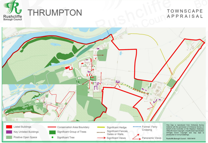
Map showing the location of:
- Conservation Area boundary - red line
- Listed buildings - red
- Unlisted buildings - purple
- Positive open space - green
- Significant group of trees - dark green dots
- Significant views - red arrows
- Significant gate, wall or fence - dotted line
- Significant hedges - light green line
- Former ferry crossing - blue dotted line
Conservation Areas
- Bingham Conservation Area
- East Bridgford Conservation Area
- East Leake Conservation Area
- Hawksworth Conservation Area
- Hickling Conservation Area
- Ruddington Conservation Area
- Thoroton Conservation Area
- Wiverton Conservation Area
- Langar Conservation Area
- West Leake Conservation Area
- Whatton in the Vale Conservation Area
- Costock Conservation Area
- Sutton Bonington Conservation Area
- Upper Saxondale Conservation Area
- Wysall Conservation Area
- Bradmore Conservation Area
- Car Colston Conservation Area
- Scarrington Conservation Area
- Orston Conservation Area
- Flintham Conservation Area
- Edwalton Conservation Area
- Aslockton Conservation Area
- Bunny Conservation Area
- Granby Conservation Area
- Keyworth Conservation Area
- Thrumpton Conservation Area
- Normanton on the Wolds Conservation Area
- Upper Broughton Conservation Area
- Kneeton Conservation Area
- Colston Bassett Conservation Area
- Cropwell Bishop Conservation Area