Scarrington Conservation Area
Scarrington Conservation Area Appraisal and Management Plan March 2024

Contents
1.1 Conservation Areas
1.2 The Purpose of a Conservation Area Character Appraisal
1.3 The Planning Policy Context
2 Scarrington Location and Landscape Setting
2.1 Scarrington Conservation Area
3.1 Location and Historic Activities
3.2 Archaeology
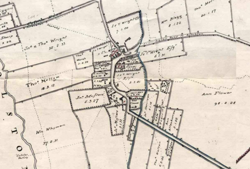
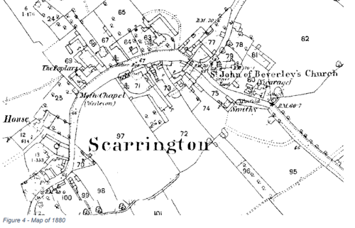
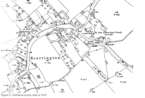
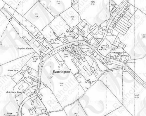
3.3 Historical Mapping
4.1 Plan, Form and Layout
4.2 Landmarks, Focal Points and Views
4.3 Open Spaces, Trees and Landscape
4.3.1 Open Spaces, Trees and Landscape SWOT Analysis
4.4 Public Realm
5 Buildings of the Conservation Area and Key Characteristics
5.1 Building Types and Activity
5.1.1 Building types and Activity SWOT Analysis
5.2 Key Characteristics and Building Materials
5.2.1 Key Characteristics
5.2.2 Key Characteristics: SWOT Analysis
5.3 Listed buildings
5.4 Key Unlisted Buildings
6.1 Introduction
6.2 National and Local Policies and Guidance
6.3 Article 4 Directions
6.4 Building Design
6.5 Publicity and Knowledge Transfer
6.6 Public Realm
6.7 Boundary Treatments
6.7.1 Walls and Fences
6.7.2 Hedges
6.8 Buildings at risk
6.9 Enforcement
7 Appendix 1 – Listed Buildings (as of February 2024)
8 Appendix 2 – Conservation Area Boundary and Townscape Appraisal Map
1 Introduction
1.1 Conservation Areas
Rushcliffe Borough Council has an obligation under Section 69 of the Planning (Listed Buildings and Conservation Areas) Act 1990 to review, from time to time, its Conservation Area designations.
A Conservation Area, as defined under Section 69, is ‘an area of special architectural or historic interest the character or appearance of which it is desirable to preserve or enhance’.
Scarrington Conservation Area was designated in 1990. Prior to this reappraisal of 2024, the Scarrington Conservation Area was reviewed in October 2010.
Section 71 of the Planning (Listed Buildings and Conservation Areas) Act 1990 highlights the local planning authority’s duty to formulate and publish proposals for the preservation and enhancement of the conservation areas. This document, therefore, aims to identify and reaffirm (or redefine) the special architectural or historic interest of the area which warrants its designation.
Conservation Area Appraisals are not, and never have been, tools for to fossilise a place against change, instead, the processes of change which allow places to grow and evolve are recognised as being unavoidable, and it is also recognised that change can be a positive and desirable force. The designation instead allows greater scrutiny and control to manage change to positive effect and to ensure that any changes which require planning permission do not harm, and ideally serve to actively enhance, the existing character of the place.
Scarrington Conservation Area: Summary of Special Interest
A typical Nottinghamshire village with an informally arranged collection of mostly 18th and 19th century traditional buildings and later infill development.
The Church of St John of Beverley provides the principle focal point for the village.
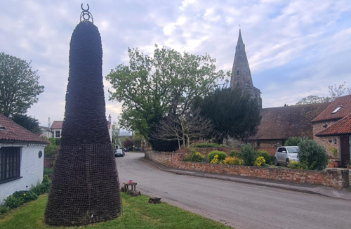
The Scarrington horseshoe pile is a unique and distinctive feature.
The 19th century pinfold is a rare example of a once common feature of Nottinghamshire villages.
The tree lined Main Street runs north-east/south-west and forms the principal thoroughfare.
The rural surroundings of the village provide views across open countryside, and tree and hedgerow lined approaches.
1.2 The Purpose of a Conservation Area Character Appraisal
The purpose of a Conservation Area Character Appraisal is to:
- Identify and record the special interest of the Conservation Area to ensure there is public awareness and understanding of what is worthy of preservation.
- To define and reassess current boundaries to accurately reflect what is now perceived to be of special interest.
- To identify opportunities to safeguard and enhance the special interest of the Conservation Area.
It should be noted that the content in this document is not a comprehensive account of every significant building, structure, tree, wall, feature, or space. Therefore, any omission should not be assumed to imply that they are of no interest.
Generally, the character and appearance of a Conservation Area will be preserved or enhanced by:
- Providing controls and regulating development through the planning system.
- Applying the extra controls that designation provides over demolition, minor development, and the protection of trees.
- Environmental enhancement schemes and possibly providing financial assistance for the repair and restoration of specific buildings.
- Encouraging public bodies such as the local highways authority or utility companies to take opportunities to improve the street scene through the appropriate design and sensitive sighting of street furniture (and retention of historic features of interest), or the removal of eyesores and street features that have a negative impact such as overhead wires.
Scarrington Conservation Area: Summary of Key Issues
- Unsympathetic new development
- Unsympathetic street furniture
- Loss of off-street parking spaces
1.3 The Planning Policy Context
This appraisal provides a firm basis on which applications for development within the Scarrington Conservation Area would be assessed. It should be read alongside the wider development plan policy framework produced by Rushcliffe Borough Council and other National Planning Policy Guidance documents. The relevant documents include:
- Rushcliffe Local Plan Part 1: Core Strategy, with a specific focus on:
- Policy 10 (Design and Enhancing Local Identity) [in part]
- Policy 11 (Historic Environment)
- Rushcliffe Local Plan Part 2: Development Policies, with a specific focus on:
- Policy 28 (Conserving and Enhancing Heritage Assets)
- Policy 29 (Development Affecting Archaeological Sites)
- The National Planning Policy Framework (NPPF) (Revised -2021)
- The National Planning Practice Guidance (2015 - Subject to Continual Review)
- By Design: Urban Design in the Planning System – Towards Better Practice (2000)
- The Planning (Listed Buildings and Conservation Areas) Act 1990
2 Scarrington Location and Landscape Setting
Rushcliffe Borough forms the southern tip of Nottinghamshire, which borders Leicestershire. It is predominantly a rural Borough that contains a mixture of city suburbs, market towns and villages. Rushcliffe is located about half a mile South of Nottingham city centre, with the River Trent forming the majority of its northern boundary and the River Soar defining its western boundary.
The A46 (Fosse Way), a distinctive Roman Road, runs through the centre of the Borough and leads to Newark in the North and Leicester in the South. In the northern half of the Borough, the A52 forms Nottingham’s primary transport link to Grantham and the East of England. Junction 24 of the M1 and East Midlands Airport are located about 1 mile from the western border.
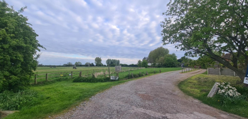
Scarrington is situated approximately 2 miles to the east of the Fosse Way in gently undulating farmland to the east of Nottingham. The surrounding countryside consists primarily of large pasture and arable fields lined with hedgerows and scattered trees. Scarrington is surrounded by a number of villages, within a radius of 1½ - 2½ miles, while the town of Bingham is situated 2½ miles to the south-west.

2.1 The Scarrington Conservation Area
The Scarrington Conservation Area encompasses most of the village’s built-up region and includes four Listed Buildings. The conservation area was designated in 1990 following a Planning Committee decision to designate ten new Conservation Areas.
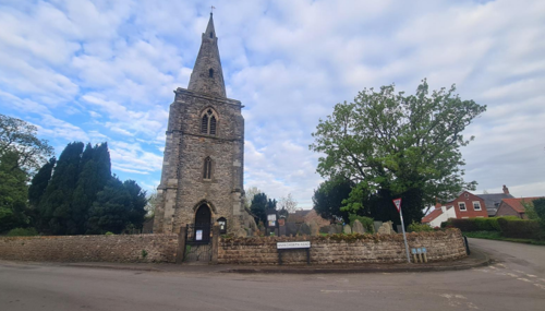
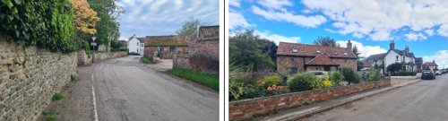
The charm of Scarrington lies in the harmonious blend of its historic, informally arranged buildings; diverse traditional boundary treatments; scenic abundance of mature trees. The village’s curving main road provides a delightful progression of views—from the rural southern approach, through the shaded Main Street, and culminating at the picturesque churchyard of St John of Beverley, a 13th-century Grade 1 listed church, to the east.
A notable feature of Scarrington’s history is the famous stack of horseshoes. Village blacksmith George Flinders spent 20 years creating this colossal stack, which became a local curiosity.
- Conservation Area Boundary covers: ?? hectares (approximate)
- Number of Grade 1 listed buildings: 1
- Number of Grade 2* listed buildings: 0
- Number of Grade 2 listed buildings: 3
A full list of Scarrington Conservation Area’s Listed buildings can be found in Appendix 1.
3 Historical Contexts
3.1 Location and Historic Activities
Scarrington's roots are believed to go back over 2,000 years, beginning as a settlement of ancient Britons. They established a camp fortified by a moat and stockade, remnants of which were reportedly visible until the early 19th century. Archaeological findings further support habitation by pre-Roman settlers.
By Saxon times, Scarrington thrived as a rural farming community. Land was divided into scattered strips, allocated to families in a system reflecting democratic governance. The village was part of the Bingham Hundred and Newark Wapentake, emphasising its administrative importance.
The Danish invasions of the 9th century brought additional cultural shifts. Saxon and Danish architectural influences are still visible, notably around the base of the village church. Listed in the Domesday Book of 1086 as "Scarintone," the name is thought to derive from “Scarringass,” linked to a prominent local figure. Post-Norman Conquest, Scarrington was documented as a modest community of ploughs, villains, and bordars in the Domesday Book. Over time, notable families such as the de Whattons and the Shipmans, whose stewardship influenced the village's development.
The Church of St John of Beverley, with features dating back to the 13th and 14th centuries, is a key historical landmark, with its 13th-century lancet windows, a 14th-century tower and spire, and a 17th-century font. The Civil War of the mid-17th century brought unrest to Scarrington. Cromwellian troops occupied the village, desecrating the church and its yard. Local tales recount acts of bravery and tragedy.
The 19th century saw significant changes to both the village and the church. Scarrington became a parish in 1867, prompting renovations such as the addition of a south aisle and the removal of deteriorated features. By the mid-19th century, the village had a population of 230, thriving with prosperous farms. Local anecdotes from this period reveal a vibrant community life, with stories of Scarrington’s band, agricultural traditions, and lively characters.
The church spire and tower were repaired in 1896. Other historic structures like the medieval Old Hall and the cottages at Lunnon also contribute to the village's charm. Scarrington’s unique traditions, including the “Scarrington pie” and humorous village tales, further enrich its character.
A rare surviving 19th-century pinfold stands as a testament to Scarrington’s agricultural past. Used to impound straying animals, pinfolds were a common feature of rural Nottinghamshire during the medieval period. This structure likely marks the site of much older versions.
The geographical size of the village remained largely unchanged since its enclosure in 1781 until the late 20th century when development extended north along Hawksworth Road. Most buildings date from the 18th and 19th centuries, characterised by a mix of detached houses, cottages, farmhouses, and agricultural structures that preserve Scarrington’s rural heritage.
Through centuries of change, Scarrington has retained its rural identity and charm.
3.2 Archaeology
A collection of lithic tools, including a scraper and flake, dating from the Middle Palaeolithic to the Late Bronze Age (circa 70,000 BC to 701 BC), were discovered on the outskirts of Scarrington.
3.3 Historical Mapping
4 Spatial Analysis
The relationship between open spaces and the built form within a conservation area can be central to its character. This section describes the village’s layout, highlighting the significant views, landmarks and historical focal points. The contribution of open green spaces, trees and other natural elements to the conservation area’s character is also described within this section.
4.1 Plan, Form and Layout
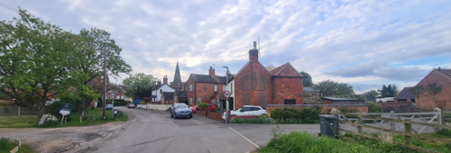
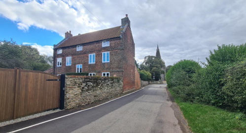
The historic street layout of Scarrington is characterised by a distinctive crescent-shaped main thoroughfare, Main Street. The initial north-south alignment of Main Street curves eastward, and transitions into a northwest-southeast orientation. Main Street serve as the village’s principal route.
Along Main Street, Hawksworth Road branches off to the northeast towards Hawksworth, providing an alternative route in and out of the village to the village. Main street then continues as Aslockton Road and then as Mill Lane (which leads to Aslockton).
Two named cul-de-sacs, The Saucers and Chapel Lane, extend from the crescent of Main Street. These cul-de-sacs primarily lead to modern infill developments that, while not visible from Main Street, mostly still complement the historic core.
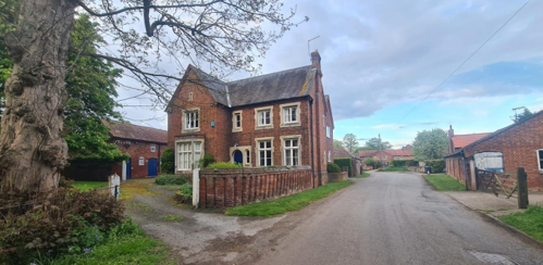
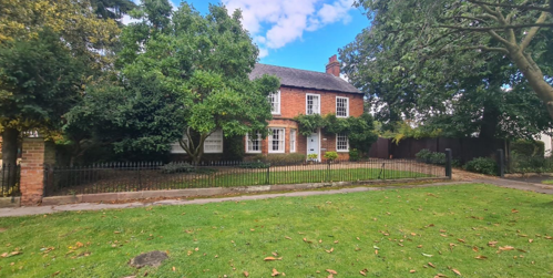
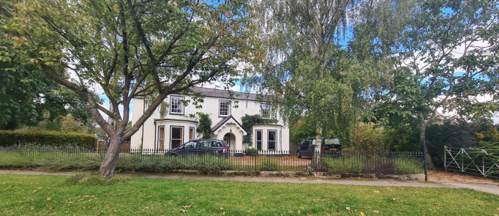
Historic buildings, ranging from farmhouses to cottages, line both sides of Main Street, and Mill Lane, and the lower stretch of Hawksworth Road. Larger detached houses and traditional farmhouses are typically set back from the road, occupying expansive plots of land, while smaller cottages often sit directly at the pavement's edge.
This contrast between smaller buildings close to the pavement and larger properties set further back enhances the open, rural character of Main Street. Complementing this, many traditional farm buildings are built directly against the roadside without pedestrian walkways, highlighting their agricultural heritage.
Modern infill developments which are not accessed via cul-de-sacs are interspersed among the historic structures along Main Street. These occasional modern additions, typically comprising individual buildings, are limited in number and designed to preserve the visual dominance of the historic built environment. This careful balance sustains the village's historic character and reinforces its overall architectural significance.
Below is a map that further describes the current plan, form and layout of the village/town.

This map is reproduced from Ordnance Survey material with the permission of Ordnance Survey on behalf of the Controller of His Majesty’s Stationary Office © Crown Copyright. Unauthorised reproduction infringes Crown Copyright and may lead to prosecution or civil proceedings.
Rushcliffe Borough Council - 100019419
4.2 Landmarks, Focal Points and Views
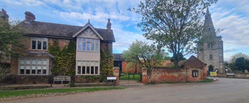
The most prominent landmark in Scarrington is the 13th-century Church of St. John of Beverley, located in the northern part of the village. The church dominates views along Main Street from the northwest and southeast, as well as along Hawksworth Road from the north, with additional glimpses visible throughout the village and surrounding countryside.
Road and Main Street
from Mill Lane
The Church of St John of Beverly is also visible to the left
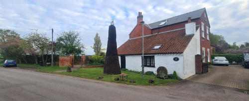
A unique landmark in Scarrington is the 5.2-metre-high horseshoe pile, which is visible from the northwest along Main Street. It situated outside the former Smithy on Main Street at the eastern edge of the village – together the building and the horseshoe pile reflects the village’s blacksmithing heritage.
Constructed between June 1945 and April 1965 by local blacksmith George Flinders, who served at the Scarrington forge for 51 years, this monument comprises approximately 50,000 interlocked horseshoes. Recognised as the largest known stack of used horseshoes in the world, the structure is self-supporting, redundant of any internal column, and weighs an estimated 10 tons. Its base has a circumference of roughly 6 metres, further underscoring its scale.
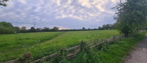
Open views of the countryside and pasture can be enjoyed from the edges of the Conservation Area at the eastern end of Mill Lane Road, from Chapel Lane, and along the hedgerow-lined lanes leading out of the village. From within the village along Chapel Lane from Main Street. These views of open spaces contribute to the rural character of the village.
The curving roads at the village core create an inviting sense of movement, drawing you through the area. The larger historic buildings, alongside agricultural and former agricultural structures, offer a glimpse into the village's farming heritage. This legacy is reflected in the form and arrangement of the buildings, which contribute to the narrative of the village's agricultural past as you walk through.
4.3 Open Spaces, Trees and Landscape
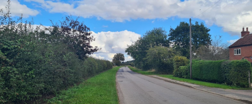
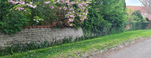
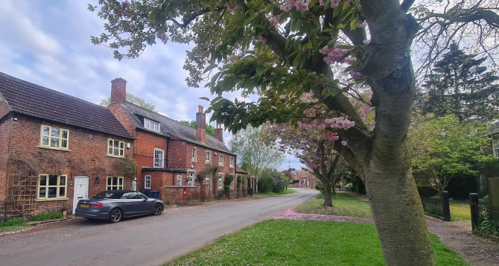
Scarrington is set within an open, verdant landscape, easily accessible via public footpaths. On approach to the village, hedgerows and tree-lined grass verges reinforce the rural setting and charm.
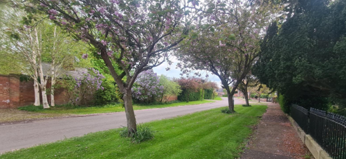
The village is home to numerous mature trees, each contributing to its green, leafy character. Along Main Street, many trees frame glimpses of detached houses set behind them (see Figure 15 and Figure 16), while
others rise prominently above the smaller, more modest properties (see the background of Figure 11).
Within the village, key open spaces include the churchyard in the east and the field between Main Street and The Saucers in the west. This piece of land contributes further to the sense of openness within the village, despite the hedge that surrounds it.
Main Street
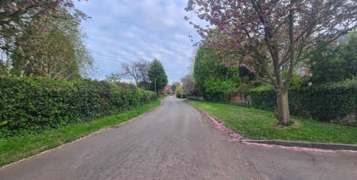
The wide grass verges and trees along Main Street create a sense of spaciousness, while grass verges throughout the village enhance its rural character and soften the built environment. In spring, the blossoming trees add warmer tones to the streetscape, further enriching the village’s charm (see Figure 13 and Figure 14).
with the wide grass verges, softening the built environment
In some cases, the wide grass verges, along with metal railings as a boundary treatment allow for the visual continuation of grass, contributing to the open, spacious feel along the street (see Figure 15).
4.3.1 Open Spaces, Trees and Landscape SWOT Analysis
Strengths - what are the positives of the open spaces, trees, and landscape
- Green open space in The Saucers
- Many attractive and mature trees
- Blossoming trees in the spring
- The wide grass verges and the properties
Weaknesses - what are the negatives of the open spaces, trees, and landscape
- None identified
Opportunities – what could make the open spaces, trees, and landscape better?
- None identified
Threats - what would make open spaces, trees and landscapes worse?
- Encroachment from nearby development
- The loss of positive open space within the village
- Development that contributes to a loss of the village’s sense of openness
Works to Trees
You must contact the Local Planning Authority (LPA), Rushcliffe Borough Council before any works (cutting OR pruning) are carried out to trees within the Scarrington Conservation Area.
Six weeks’ notice is required before any works to trees within the Conservation Area is carried out, even if they are not protected by a Tree Preservation Order (TPO).
If there is a tree which undergoes annual maintenance, include this information with the notice. It may be possible, upon agreement with the tree officer, that only one notice is required to cover the future annual maintenance.
Standard notification forms (a section 211 notice), further information and contact details.
A flow chart of the decision-making process regarding works to trees.
4.4 Public Realm
Boundary treatments in Scarrington vary in material and style but are typically low in height, allowing attractive glimpses into front gardens and, ultimately, contributing to the village's open character.
Black metal railings (see Figure 15, Figure 16 and Figure 20), often set on low brick or stone bases, are a common boundary treatment characteristic of the area. These railings are complemented by brick walls, stone walls, and hedges. Occasional painted wooden fences and painted brick walls add variety.
grows above
Roads in the village are surfaced with asphalt and bordered by grass verges or asphalt pavements. Many driveways are gravelled, blending well with the rural setting (see Figure 20).
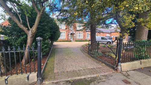
Block paving separates a gravel drive from the pavement at Yew Tree House
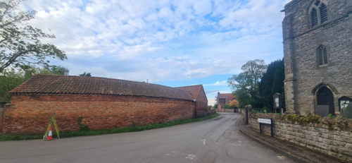
At the junction of Hawksworth Road and Main Street, a traditional farm building, The Gables, backs directly onto the road, contributing to the agricultural character of the village (see Figure 25).
The historic street furniture adds to the village's character, with a traditional K6 red telephone box on Main Street (see Figure 21) and red post-box (see Figure 22) built into a wall at Beech House (see Figure 28). There is a cast iron finger signpost on Main Street all making a positive contribution to the streetscape.
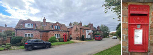
George VI traditional red post box on Main Street
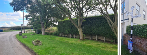
Signpost with County Roundel
The contemporary street furniture includes a few memorial benches and planters at the edge of the Conservation Area nearing Mill Lane near mill lane and planters (see Figure 23).
5 Buildings of the Conservation Area and Key Characteristics
5.1 Building Types and Activity
The Conservation Area features a variety of building types, sizes, and heights, adding visual interest and character. While buildings are predominantly one or two storeys, there are the odd three storey houses. Other properties include detached houses, semi-detached cottages, and linked farm structures.
The village also displays a range of building ages, with notable examples from the late 18th and early 19th centuries. These include workers’ cottages, substantial Georgian and Edwardian houses, and traditional agricultural buildings and outbuildings.
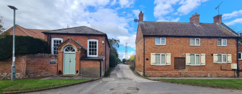
The School House, is Victorian in character with its red brick, blue diaper work, and segmented arch windows, has been converted into a residential dwelling. The Old Chapel, once briefly used for commercial purposes, now also serves as a home.
The Church of St John of Beverley remains in use as a place of worship, contributing to the village's historic fabric.
Beyond residential use, the presence of a few remaining active farms continues to reflect the village’s rural heritage and character.
Chapel Lane from Main Street
windows and steep roof pitch required for the original thatch
5.1.1 Building types and Activity SWOT Analysis
Strengths - what activities/places can you go that make the village/town great?
- Strongly residential character emphasised by lack of commercial and industrial activity
- Presence of active farming
Weaknesses - what activities/places exist that detract from making the village/town great?
- None identified
Opportunities - what activities/places could exist that would village/town even better?
- None identified
Threats - what activities/places would make village/town worse?
- Conversion of garaging into residential use causing loss of off-street parking space and increase of on-street parking
- Highways changes to the A52 and A46 potentially resulting in traffic using Scarrington as a ‘rat run’.
5.2 Key Characteristics and Building Materials
Traditional building materials were largely locally sourced. Bricks for example, were not transported far from where they were made, leading to interesting village specific sizes, colours and styles. Roofs would have been made from local materials such as thatch, stone and clay.
Materials:
The traditional building materials within the Conservation Area are as follows:
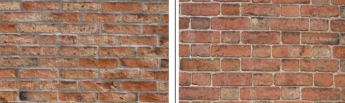
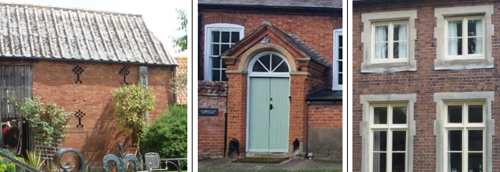
Walls: Traditional buildings in Scarrington are primarily constructed of red brick, with occasional examples of white-painted brick, stone, or rendered facades. The most common brickwork patterns are Flemish bond and stretcher bond, with rare instances of English bond.
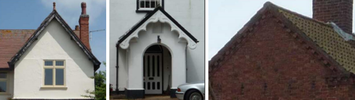
Roofs: Roofs are predominantly made of clay pantiles, particularly on smaller cottages and former farm buildings. Larger detached houses and farmhouses often feature Welsh slate roofs, while plain tiles are occasionally used. Chimneys are typically constructed of red brick, simply designed, and positioned either along the roof ridge or within the gable walls.
Windows: Windows are predominantly painted timber casements or vertically sliding sashes with slim glazing bars. Arched brick lintels are the most common feature, often incorporating blue bricks for decorative effect, although some examples of ashlar lintels also exist.
Key Characteristics / Architectural Features:
The small, compact nature of Scarrington gives the Conservation Area a consistent character, defined by a scattering of historic buildings interspersed with modern infill development. The village is notable for its rural, verdant setting, red brick buildings, and compact linear layout.
Traditional buildings in the village are relatively restrained in decoration, with subtle architectural detailing. Dentil courses are the most common decorative feature, while some older buildings display blue brick patterns or yellow-and-red Flemish bond or checkerboard designs. Missing-brick patterns can occasionally be seen on former agricultural structures.
Many buildings retain steeply pitched roofs, originally designed for effective water run-off. Gable-end finials appear occasionally, adding subtle ornamentation, while rainwater goods are traditionally made of cast iron.
Glazed over-lights above doorways are a notable feature, particularly on the village's grander buildings. These are often paired with brick or timber-framed porches, showcasing styles that range from neo-classical and gothic to Edwardian.
on main Street; Figure 32 - neo-classical style porch, overlight and
vertically sliding sash window on the Wesleyan Chapel on Main Street
and Figure 33 - timber casement windows in stone surrounds on Main Street
Main Street; Figure 35 - Arts & Crafts style porch on a house on Main
Street and Figure 36 - brick dentil detailing on a farmhouse on Main Street
5.2.2 Key Characteristics SWOT Analysis
Strengths – what is good about most existing buildings /streetscape that contributes to the character of the Conservation Area?:
- Distinctive horseshoe pile, a landmark and characteristic of the area
- The pinfold
- A large number of attractive buildings
- K6 Red telephone box and letter box
- Small size of village
- Predominance of traditional red brick in various bonds
- Attractive street scene with a variety of trees and wide grass verges
- Boundary treatments afford glimpses and views into fore gardens and houses which gives an open feel to the village
Weaknesses – what is not so good about most existing buildings / the streetscape that detracts from the character of the Conservation Area?
- Unsympathetic modern infill development
- Unsympathetic street furniture, road signs and lighting
Opportunities – what could make existing buildings (or new builds) look good and contribute to the character of the area?
- Change the street furniture to a more sympathetic design
Threats – what could make existing buildings (or new builds) look worse and detract from the character of the area?
- Installation of unsympathetic windows
- Loss of railings as a boundary treatment
5.3 Listed buildings
Buildings on the Government’s List of Buildings of Special Architectural or Historic Interest are called “Listed” buildings and are protected by law. Consent is required from Rushcliffe Borough Council before any works of alteration, extension, or demolition can be carried out on any listed building.
Further information can be found in Rushcliffe Borough Council’s publication Listed Buildings in Rushcliffe.
There is also the complete and up-to-date list of the Secretary of State’s Statutory List of Buildings of Special Architectural Interest or Historic Interest.
Names of the Listed Buildings and structures in Scarrington Conservation Area (correct as of February 2024) are detailed in Appendix 1. All Listed Buildings are shown on the Townscape Appraisal plan, but some smaller structures such as gravestones may not be shown.
Scarrington contains four Listed Buildings or structures - the Church of St John of Beverley is Grade 1 listed.
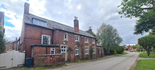
The Old Hall (see Figure 37), The Smithy and The Pinfold (see Figure 38) are Grade 2 listed. The Old Hall, built around 1700 with later 18th and 19th-century additions, is a distinctive farmhouse originally for the Shipman family. Made of brick with plain tile and pantile roofs, it has an L-shaped plan, two storeys, and attics. Key features include gabled and lean-to designs, dentillated eaves, coped gables, and a mix of 19th and 20th century windows (see Figure 37).
and gable end on to the road. Hawksworth Road
The Smithy, dating from around 1840 with alterations in 1890, is a single-storey brick building with a whitewashed exterior and a lean-to pantile roof. It features dentillated eaves, two bays, and a single gable with a roof stack. The windows include 19th and 20th century casements, with a casement and plank door on the front, and a barred 19th century casement on the northwest end (see Figure 38).
The Pinfold, dating from the mid-19th century, is a circular brick structure with stone dressings and a gabled brick coping. It features an altered opening with a chamfered brick pier and a single stone impost, along with a 19th-century spiked wrought iron gate and a 20th-century addition (see Figure 38).
5.4 Key Unlisted Buildings
Contribution to the established character of the place can also come from buildings which are not recognised via listing, or are not old. A plan with all of the positive contributions to the area can be found in Appendix 2 - Conservation Area Boundary and Townscape Appraisal Map.
Much of the special interest of the Scarrington Conservation Area is derived from the mix of large detached dwellings, workers’ cottages, outbuildings and traditional agricultural buildings, which link the village with its past.
The Scarrington Conservation Area includes a number of key unlisted buildings that make a positive contribution to the character and appearance of the Conservation Area. Planning guidance stresses the importance of protecting such buildings.
6 Generic Management Plan for Conservation Areas in Rushcliffe
6.1 Introduction
In carrying out its planning functions, the Borough Council is required in law to give special attention to the desirability of preserving or enhancing the character or appearance of Conservation Areas. The Management Plan for a Conservation Area is a tool to ensure the special character of the area is preserved and enhanced. The management plans aim to:
- Outline a strategic management proposal for the preservation and enhancement of the Scarrington Conservation Area.
- Act as a guide for professionals and residents alike regarding:
- features of value, worthy of preservation;
- characteristics worthy of preservation;
- opportunities for enhancement;
- development proposals which preserve and enhance the special character of the area.
- Inspire community commitment to conservation principles and reporting.
6.2 National and Local Policies and Guidance
There is a duty to formulate and publish management plans setting out policies and proposals for the preservation and enhancement of Conservation Areas. Many of these policies and proposals are common to all Conservation Areas, and these are set out in this document. The Central Government Guidance and Local policies applicable to Conservation Areas include:
- Rushcliffe Local Plan Part 1: Core Strategy, with a specific focus on:
- Design and Enhancing Local Identity [in part]
- Historic Environment
- Rushcliffe Local Plan Part 2: Development Policies, with a specific focus on:
- Conserving and Enhancing Heritage Assets
- Development Affecting Archaeological Sites
- The National Planning Policy Framework (NPPF), particularly, but not exclusively the chapter on Conserving and Enhancing the Historic Environment.
- The National Planning Practice Guidance (NPPG) (updated 2021 and subject to continual review)
- By Design: Urban Design in the Planning System – Towards Better Practice (2000)
- The Planning (Listed Buildings and Conservation Areas) Act 1990
- Historic England “Historic England Advice Note 1: Conservation Area Designation, Appraisal and Management”
The council will utilise the full range of strategic policy and guidance documents to ensure that development in Scarrington Conservation Area is of a standard that enhances the amenity of the local area. The council will always look to use the most up-to-date versions of the document.
Supplementary documents may be issued for individual Conservation Areas where specific policies or proposals are needed.
6.3 Article 4 Directions
There are extra consents required in Conservations Areas. For example, in addition to the general control of development, you will need to get permission for
- Any additions or alterations to the roof (for example, dormer windows)
- The installation of satellite dishes on chimneys, roofs or walls fronting a highway
- Any extension which extends beyond the side of the original dwelling house
- Any extension of more than one storey that extends beyond the rear wall of the original dwelling house
- Cladding the exterior of the dwelling
- Any demolishing of a building or part of a building that has a volume over 115 cubic metres
Article 4 of the Town and Country Planning (General Permitted Development) Order 1995, allows planning authorities to restrict some permitted development rights within particular areas. This does not necessarily prevent development or change taking place but enables the Local Authority to manage the design and detailing of the works, and potentially grant permission subject to appropriate conditions. The use of Article 4 Directions will be proposed where it is considered appropriate following the completion of each Area Appraisal across the Borough.
Details of Article 4 Directions for Scarrington Conservation Area
There are currently no Article 4 Directions for Scarrington Conservation Area.
6.4 Building Design
Mimicking the local vernacular is not the only way to ‘fit in’ with the character of a conservation area. National policy makes clear that contemporary designed, provided it is sympathetically designed, cannot be dismissed as an option. Therefore, good contemporary design will be encouraged where it respects the context’s character, scale and massing. This must be demonstrated in the Design and Access Statement submitted with any planning application.
Extensions to buildings in Conservation Areas should respect:
- The key characteristics of the original building, including scale, mass, materials and proportions
- The contextual setting and character of the Conservation Area
Copying like for like can devalue and destroy the ability to “read” historic change, and dilutes our historic heritage. Pastiche designs, incorporating poor imitations of other styles, will be resisted, particularly where they incorporate details which are not locally appropriate. Careful high-quality replication may be required in a few very sensitive locations.
In particularly sensitive locations, such as uniform terraces, exact replication may be necessary to maintain compositional unity. In that case, attention to details, choice of materials and high-quality workmanship are the keynotes. However, in some cases, a direct relationship is not impossible. For example, Flemish Bond brickwork cannot be replicated in cavity walls, and narrow lime mortar joints cannot be replicated in modern metric brickwork.
Where a new building is appropriate, on infill sites or where an existing building detracts from the character of the area, the opportunity should be taken to re-establish the streetscape, reinforce enclosure, open up distant vistas or views of landmarks or hide unsightly views.
“New and old buildings can coexist happily without disguising one as the other, if the design of the new is a response to urban design objectives” (DETR – “By Design”, p19).
As with extensions, good contemporary design which respects local character, and the context of the site will be encouraged.
All new buildings should respond appropriately to the existing frontage and normally follow the established building line. Development or redevelopment will normally be resisted if:
“it blocks important views identified in the individual appraisals, uses important open spaces identified in the appraisals, adversely affects the setting of any Listed or key buildings, fails to maintain or re-establish the streetscape where appropriate dominates its Conservation Area background fails to recognise the context of the site destroys important features identified in the individual appraisals such as boundary walls, fences, hedgerows or trees”
Where the quantity of contemporary schemes in a small area becomes significant and outnumbers older buildings within the area, further contemporary schemes could fundamentally shift the architectural character of the area and thus be harmful, even if well designed as an individual project.
New development that stands out from the background of buildings may be appropriate in exceptional circumstances if it contributes positively as a landmark to enhance the street scene, to highlight a corner or to signal a visual change of direction such as along a curving vista.
Any external lighting should be carefully designed and sited to minimise light pollution. Energy producing or saving devices are generally welcomed by the Council, but careful consideration is required when these are to be located in a Conservation Area and some may require planning permission. In particular, they should be positioned to minimise their impact on the building and on the local amenity.
6.5 Publicity and Knowledge Transfer
Ambiguity about additional controls within a Conservation Area raises the likelihood of inappropriate developments occurring which may damage the integrity of the conservation area designations.
Efforts have been made to engage local community groups in the development and review of the character appraisals. Empowering communities to define the special architectural and historic interest of the Conservation Area aims to raise awareness.
Whether the appraisal took a community-led or a council-led approach, upon reviewing all Conservation Areas, the public were invited to ask questions and comment during a public consultation. A consultation event also aimed to diminish any ambiguity about restrictions within a Conservation Area and increase the likelihood of sensitive and appropriate developments, maintaining the character of the area.
The council recognise the potential issues of turnover in residency and ownership of properties in the conservation area. Therefore, Rushcliffe Borough Council will periodically use their media outlets to highlight conservation area designations and the significant, related planning controls.
The approach taken within Scarrington Conservation Area was a Council Led
The consultation period took place between the following dates 19/02/2025 and 16/03/2025
The date of the Consultation Event - 06/03/2025
If there are any queries about conservation areas, please email conservationareas@rushcliffe.gov.uk
6.6 Public Realm
General maintenance and upkeep to the public realm may include fixing damage to roads and pavements, and fixing issues with street lighting. Issues such as these can impact the quality of the Conservation Area.
The council aims to encourage works to the public realm that are in keeping with, or actively enhance the conservation area. Rushcliffe Borough Council can only advise on work within the public realm that does not require planning permission (for example work completed by statutory undertakers, such as the Highways Authority). In these instances, Rushcliffe borough council cannot prevent such work.
Nottinghamshire County Council are responsible for repairs to roads, pavements and street lighting. Report issues of repairs to roads, pavements and street lighting to Nottinghamshire County Council online.
Rushcliffe Borough Council will continue to undertake their duties in maintaining the public realm. Vandalism, fly tipping and street cleaning are all the responsibility of Rushcliffe Borough Council. Report issues to Rushcliffe Borough Council online.
You must contact the Local Planning Authority (LPA), Rushcliffe Borough Council, before any works (cutting OR pruning) are carried out to trees within the Scarrington Conservation Area
Six weeks’ notice is required before any works to trees within the Conservation Area is carried out, even if they are not protected by Tree Preservation Order (TPO).
Standard notification forms (a section 211 notice) - further information and contact details.
A flow chart of the decision-making process regarding works to trees.
6.7 Boundary Treatments
Where there is a proposal for a new boundary treatment to be installed, the council would encourage the use of boundary treatments within the area.
Within conservation areas, planning permission is required to alter, maintain, improve, take down or build any new gate, fence, wall or other enclosure with:
- A height of one metre or more if next to a highway (including a public footpath or bridleway), waterway or open space; or
- A height of two metres or more elsewhere.
Where planning permission is required to remove a wall, Rushcliffe Borough Council will aim to protect those boundary walls and fences that have been identified as positively contributing to the area.
Hedgerows are significant habitats for wildlife in lowland Britain. Regulations are intended to protect important hedges in the countryside. The policy applies to hedges that are more than 20m long, (or less if connected to another hedge) on or adjacent to:
- Land used for agriculture or forestry, including the keeping of horses or donkeys
- Registered common land and village greens
- Local Nature Reserves and Sites of Special Scientific Interest.
The policy does not apply if the hedge is within or on the boundary of the curtilage of a house.
6.8 Buildings at Risk
A few of the important buildings across the various Conservation Areas are currently vacant or not in regular use, which may lead to some being “at risk” of neglect or decay.
The Council will encourage and advise on renovation and repair work that is sensitive to the original or traditional historic character of the building and retains original features. The council will monitor the opportunity and potential for grant aid schemes to encourage the basic maintenance work necessary to ensure that key buildings within the conservation area are structurally sound and weather tight. However, given the current financial climate and outlook, such schemes are unlikely in the short to medium term.
There is a presumption against the demolition of buildings which contribute to the character of the area unless there are exceptional circumstances. It would benefit both the physical form and the function of the Conservation Area if these buildings were repaired, maintained and brought back into use.
Where the poor condition of a building or structure is as a result of neglect and lack of maintenance by its owner there is no requirement for the Borough Council to take its deteriorated condition into account when deciding whether demolition is appropriate. This is to avoid rewarding the deliberate neglect of buildings by representing such action as a way to obtain planning permission for demolition and redevelopment.
6.9 Enforcement
Rushcliffe Borough Council will, from time to time, assess and monitor changes in the appearance and condition of Scarrington Conservation Area. This will ensure that where necessary enforcement action can be taken promptly to deal with problems as they arise.
Where co-operation cannot be gained by any other means, Rushcliffe Borough Council has the ability to use additional enforcement powers to tackle particular issues within conservation areas. The Council may take formal action if the condition of any building (listed or unlisted) which makes a positive contribution to the character of the Conservation Area is considered to be at risk.
The council will work in accordance with their enforcement policy, which aims to provide an efficient enforcement service in support of the Council’s statutory planning service. Rushcliffe Borough Council’s enforcement actions will remain transparent, consistent, and proportionate, as it is recognised that effective controls over unauthorised development assists in conserving the natural and built environment whilst helping to protect the quality of people’s lives and maintaining the Council’s integrity.
7 Appendix 1 – Listed Buildings (as of February 2024)
Grade: 2
Listing entry number: 1244531
National grid reference: SK 73511 41655
Location: The Old Hall, Hawksworth Road
Grade: 2
Listing entry number: 1272713
National grid reference: SK 73496 41597
Location: Church of St John of Beverley, Hawksworth Road
Grade: 2
Listing entry number: 1272714
National grid reference: SK 73500 41543
Location: The Smithy, Mill Lane
Grade: 2
Listing entry number: 1244598
National grid reference: SK 73513 41543
Location: The Pinfold, Mill Lane
*The titles of these listings may not make it clear that all listed buildings always include all attached structures and extensions, regardless of age, and all detached outbuildings built before 1 June 1948 which are, or were at the time of listing, ancillary to the function of the primary listed building and were in the same ownership at the time of listing.
For example, when a house is listed, the listing will apply to extensions, porches, detached historic stables, barns, wash houses, privies etc. Such outbuildings and extensions are only exempt from the provisions of listing where the listing specifically excludes them. Appendix 2 - Conservation Area Boundary and Townscape Appraisal Map.
8 Appendix 2 – Conservation Area Boundary and Townscape Appraisal Map

The Scarrington Townscape Map above shows:
- Conservation Area boundary - red line
- Locations of listed buildings (red)
- Locations of key unlisted buildings (purple)
- Open space
- Locations of trees, hedges, and significant hedges and fences
- Viewpoints
Conservation Areas
- Bingham Conservation Area
- East Bridgford Conservation Area
- East Leake Conservation Area
- Hawksworth Conservation Area
- Hickling Conservation Area
- Ruddington Conservation Area
- Thoroton Conservation Area
- Wiverton Conservation Area
- Langar Conservation Area
- West Leake Conservation Area
- Whatton in the Vale Conservation Area
- Costock Conservation Area
- Sutton Bonington Conservation Area
- Upper Saxondale Conservation Area
- Wysall Conservation Area
- Bradmore Conservation Area
- Car Colston Conservation Area
- Scarrington Conservation Area
- Orston Conservation Area
- Flintham Conservation Area
- Edwalton Conservation Area
- Aslockton Conservation Area
- Bunny Conservation Area
- Granby Conservation Area
- Keyworth Conservation Area
- Thrumpton Conservation Area
- Normanton on the Wolds Conservation Area
- Upper Broughton Conservation Area
- Kneeton Conservation Area
- Colston Bassett Conservation Area
- Cropwell Bishop Conservation Area