Normanton on the Wolds Conservation Area
Normanton-on-the-Wolds Conservation Area Appraisal and Management Plan January 2024

Contents
1.1 Conservation Areas
1.2 The Purpose of a Conservation Area Character Appraisal
1.3 The Planning Policy Context
2 Normanton-on-the-Wolds Location and Landscape Setting
2.1 The Normanton-on-the-Wolds Conservation Area
3.1 Location and Historic Activities
3.2 Archaeology
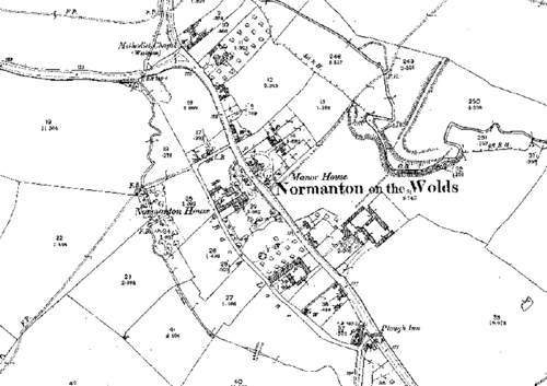
3.3 Historical Mapping
4.1 Plan, Form and Layout
4.2 Landmarks, Focal Points and Views
4.3 Open Spaces, Trees and Landscape
4.3.1 Open Spaces, Trees and Landscape SWOT Analysis
4.4 Public Realm
5 Buildings of the Conservation Area and Key Characteristics
5.1 Building Types and Activity
5.1.1 Building Types and Activity SWOT Analysis
5.2 Key Characteristics and Building Materials
5.2.1 Building materials and local details
5.2.2 Key Characteristics: Village Centre - Zone 1
5.2.3 Key Characteristics: Back Lane - Zone 2
5.2.4 Key Characteristics: Surrounding pasture and Paddocks - Zone 3
5.2.5 Key Characteristics: Site of Medieval Water Mill - Zone 4
5.2.6 Key Characteristics: SWOT Analysis
5.3 Listed Buildings
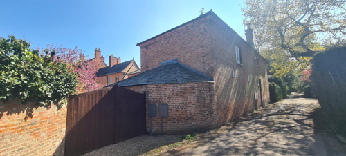
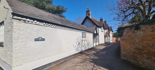
5.4 Key Unlisted Buildings
6.1 Introduction
6.2 National and Local Policies and Guidance
6.3 Article 4 Directions
6.4 Building Design
6.5 Publicity and Knowledge Transfer
6.6 Public Realm
6.7 Boundary Treatments
6.7.1 Walls and Fences
6.7.2 Hedges
6.8 Buildings at risk
6.9 Enforcement
7 Appendix 1 – Listed Buildings (as of January 2024)
8 Appendix 2 – Conservation Area Boundary and Townscape Appraisal Map
1 Introduction
1.1 Conservation Areas
Rushcliffe Borough Council has an obligation under Section 69 of the Planning (Listed Buildings and Conservation Areas) Act 1990 to review, from time to time, its Conservation Area designations.
A Conservation Area, as defined under Section 69, is ‘an area of special architectural or historic interest the character or appearance of which it is desirable to preserve or enhance’.
Normanton-on-the-Wolds Conservation Area was designated in 1990. Prior to this reappraisal of January 2024, the Normanton-on-the-Wolds Conservation Area was reviewed in September 2009.
Section 71 of the Planning (Listed Buildings and Conservation Areas) Act 1990 highlights the local planning authority’s duty to formulate and publish proposals for the preservation and enhancement of the conservation areas. This document, therefore, aims to identify and reaffirm (or redefine) the special architectural or historic interest of the area which warrants its designation.
Conservation Area Appraisals are not, and never have been, tools for to fossilise a place against change, instead, the processes of change which allow places to grow and evolve are recognised as being unavoidable, and it is also recognised that change can be a positive and desirable force. The designation instead allows greater scrutiny and control to manage change to positive effect and to ensure that any changes which require planning permission do not harm, and ideally serve to actively enhance, the existing character of the place.
Normanton-on-the-Wolds Conservation Area: Summary of Special Interest
Intimate Village Core
The centre of Normanton-on-the-Wolds is defined by high brick walls, dense hedgerows and overarching tree canopies, creating a strong sense of enclosure and seclusion.
Contrasting Rural Fringe
Encircling the built-up area, a patchwork of paddocks and small pastures opens out into expansive views of farmland, providing a striking counterpoint to the village’s wooded heart.
Generous Private Grounds
Many of the larger historic residences occupy substantial garden plots, where specimen trees, formal lawns and ancillary outbuildings contribute to the village’s distinctive character.
Architectural Diversity
A rich mix of building styles — from vernacular brick and stone cottages to more ornate Victorian and Edwardian villas — reflects Normanton-on-the-Wolds’ longstanding evolution and local craftsmanship.
1.2 The Purpose of a Conservation Area Character Appraisal
The purpose of a Conservation Area Character Appraisal is to:
- Identify and record the special interest of the Conservation Area to ensure there is public awareness and understanding of what is worthy of preservation.
- To define and reassess current boundaries to accurately reflect what is now perceived to be of special interest.
- To identify opportunities to safeguard and enhance the special interest of the Conservation Area.
It should be noted that the content in this document is not a comprehensive account of every significant building, structure, tree, wall, feature, or space. Therefore, any omission should not be assumed to imply that they are of no interest.
Generally, the character and appearance of a Conservation Area will be preserved or enhanced by:
- Providing controls and regulating development through the planning system.
- Applying the extra controls that designation provides over demolition, minor development, and the protection of trees.
- Environmental enhancement schemes and possibly providing financial assistance for the repair and restoration of specific buildings.
- Encouraging public bodies such as the local highways authority or utility companies to take opportunities to improve the street scene through the appropriate design and sensitive sighting of street furniture (and retention of historic features of interest), or the removal of eyesores and street features that have a negative impact such as overhead wires.
Normanton-on-the-Wolds Conservation Area: Summary of Key Issues
- Alterations to Listed and key unlisted properties – Rear extension at Avenue Farm is unsympathetic to the Listed farmhouse and some of the outbuildings are in need of attention.
- Public Realm – Area of hard standing on village green detracts from rural character, poor road drainage, unsightly electricity pylons and overhead wires in the south of the village, unsightly bin storage area at entrance to Chapel Yard, lack of street lighting which if introduced would need to be of an appropriate design.
- Agriculture and landscape – Threat to archaeological earthworks from intensive arable farming, potential for better planting schemes along roadsides.
- Development Pressures – Greenfield land on the outskirts of the village could be lost to housing development. Highways and Transportation – Large number of parked cars near The Plough Inn, traffic noise from the A606.
- The replacement of smaller dwelling with larger dwellings contemporary in design has the potential to erode the overall character of the conservation area.
1.3 The Planning Policy Context
This appraisal provides a firm basis on which applications for development within the Normanton-on-the-Wolds Conservation Area would be assessed. It should be read alongside the wider development plan policy framework produced by Rushcliffe Borough Council and other National Planning Policy Guidance documents. The relevant documents include:
- Rushcliffe Local Plan Part 1: Core Strategy, with a specific focus on:
- Policy 10 (Design and Enhancing Local Identity) [in part]
- Policy 11 (Historic Environment)
- Rushcliffe Local Plan Part 2: Development Policies, with a specific focus on:
- Policy 28 (Conserving and Enhancing Heritage Assets)
- Policy 29 (Development Affecting Archaeological Sites)
- The National Planning Policy Framework (NPPF) (Revised -2021)
- The National Planning Practice Guidance (2015 - Subject to Continual Review)
- By Design: Urban Design in the Planning System – Towards Better Practice (2000)
- The Planning (Listed Buildings and Conservation Areas) Act 1990
2 Normanton-on-the-Wolds Location and Landscape Setting
Rushcliffe Borough forms the southern tip of Nottinghamshire, which borders Leicestershire. It is predominantly a rural Borough that contains a mixture of city suburbs, market towns and villages. Rushcliffe is located about half a mile South of Nottingham city centre, with the River Trent forming the majority of its northern boundary and the River Soar defining its western boundary.
The A46 (Fosse Way), a distinctive Roman Road, runs through the centre of the Borough and leads to Newark in the North and Leicester in the South. In the northern half of the Borough, the A52 forms Nottingham’s primary transport link to Grantham and the East of England. Junction 24 of the M1 and East Midlands Airport are located about 1 mile from the western border.
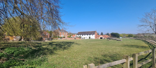
Normanton-on-the-Wolds is situated alongside the A606, Melton Road, which runs roughly northwest to southeast through the centre of Rushcliffe Borough. As its name suggests the village is located within the Nottinghamshire Wolds Character Area. Nearby settlements include the large village of Keyworth around one mile to the south, Plumtree almost immediately to the west and Tollerton a mile to the northwest. The rolling landscape around the village consists of open arable fields and pasture punctuated by areas of woodland.

2.1 The Normanton-on-the-Wolds Conservation Area
This small Conservation Area contains four Listed Buildings and was designated in 1990 as part of the Borough Council’s proposals to create ten new Conservation Areas.
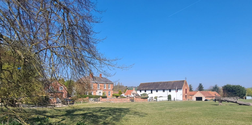
Normanton is a small, secluded village with a fairly simple plan but interest is provided by the presence of a back lane. This very green village was formerly on the main road to Melton (the village is now by-passed) and contains a succession of large houses set well back in their own grounds.
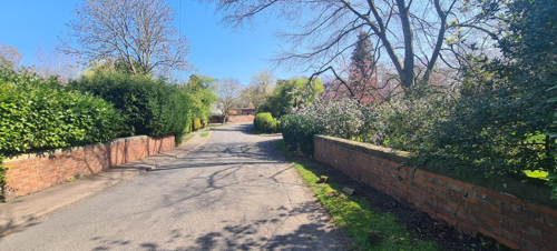
From the northern end of Old Melton Road, past the small green and around the bend, all the way down to The Plough Inn, a continuous enclosed feeling is provided by red brick walls, tall hedgerows, verges and mature trees which also gives the village a unity of character.
- Conservation Area Boundary covers: 34.3 hectares (approximate)
- Number of Grade 1 listed buildings: 0
- Number of Grade 2* listed buildings: 0
- Number of Grade 2 listed buildings: 4
A full list of Normanton-on-the-Wolds Conservation Area’s Listed buildings can be found in Appendix 1. Details accurate as of January 2024.
3 Historical Contexts
3.1 Location and Historic Activities
The small village of Normanton-on-the-Wolds has long been closely linked with its neighbour, Plumtree. Normanton has Saxon origins, with archaeological evidence in the form of four Saxon burials discovered along the Fosse Way, likely dating to the 5th or 6th century. Before the Norman Conquest, the manor at Normanton was held by a landowner named Unfac. Following the conquest, the land was granted to Roger de Busli, who held the manor at the time of the Domesday Survey, where the village is listed as Normantone. De Busli also held other nearby settlements, including Normanton-on-Soar and Normanton-on-Trent.
In the later medieval period, land ownership in Normanton appears to have changed several times. During the reign of Henry II, Simon of Keyworth donated seventeen acres of arable land to Haverholm Priory. This land was later transferred to other religious orders, including the Knights Hospitaller (also known as the Knights of Malta). A royal charter issued by King John in 1201 confirmed the gift of land in Gamston and Normanton-on-the-Wolds—fifteen bovates—to Geoffrey Luteral (or Loteral) from Gerbode de Escaud. The Luteral family retained these lands into the reign of Richard II, alongside holdings in West Bridgford, Basingfield, and Keyworth.
The landscape at this time was likely divided into a number of small agricultural plots. The frequent appearance of the word Platt—meaning 'plot of land'—in local place names supports this idea. The survival of ridge and furrow earthworks further indicates that open field farming was practiced in the area.
Following the Dissolution of the Monasteries in the 1530s, monastic lands became Crown property, including those at Normanton. In 1548, these were sold to Thomas Brende, and again in 1553 to John, Earl of Bedford, and Edmund Downing. From this point, much of the land appears to have been tenanted and then gradually sold off in parcels under Edward VI. During the 16th and 17th centuries, ownership changed hands regularly, sometimes through mutual agreement and at other times through legal proceedings.
By the time of the enclosure under Charles II, the loss of open fields was noted as "to the great loss of the church of Plumtree, to which it is parish" (Thoroton, During the reign of George III, Normanton-on-the-Wolds covered approximately 1,000 acres and consisted of around twenty dwellings. The village continued to grow into the 19th century. In 1797, Methodists from Plumtree established a chapel in the village, which was enlarged in 1827. By the reign of William IV, the settlement had expanded to around 33 dwellings.
Despite the growth in the number of dwellings, census records show that, the village’s population fluctuated greatly in the nineteenth century:
- 1800 - 102
- 1810 - 140
- 1820 - 194
- 1830 - 185
- 1840 - 210
- 1850 - 230
- 1860 - 193
- 1870 - 151
- 1880 - 99
- 1890 - 201
- 1900 - 209
The village still shows traces of its past. Place names like Toothill, meaning a lookout hill, suggest the presence of a beacon at some time. There are still some extensive earthworks including water mill complex from the medieval period of the village’s history. Many of the buildings in the village are historic in either date or location. In 1540 for example, the land on which Normanton Grange now stands was owned by Haverholm Priory.
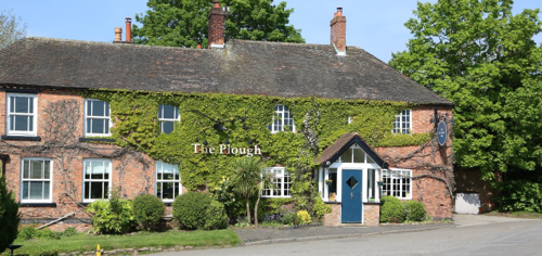
The village grew substantially during the twentieth century as a commuter village, and now has a pub, The Plough Inn, although the Wesleyan Chapel is now a private dwelling.
3.2 Archaeology
In the stream valley to the northeast of Manor House, Normanton, there are prominent earthworks that have previously been suggested as the site of “Warby.” Notably, a large mound is located south side of the stream and may represent the remains of a defensive feature, such as a burh or small fortification.
In the field to the southwest of this mound, a number of low banks are visible, which were investigated by Houldsworth in 1954. These earthworks include a well-constructed pond bay spanning the stream valley, with a sharply defined profile now covered in shrubs. Surrounding this are a series of field banks, likely of post-medieval origin, although their precise date remains uncertain.
The mound itself appears to be a natural feature—a tump formed by the diversion of the stream—rather than a man-made structure. No clear evidence has been found to confirm the presence of a former settlement in this area.
3.3 Historical Mapping
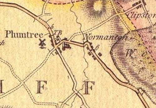
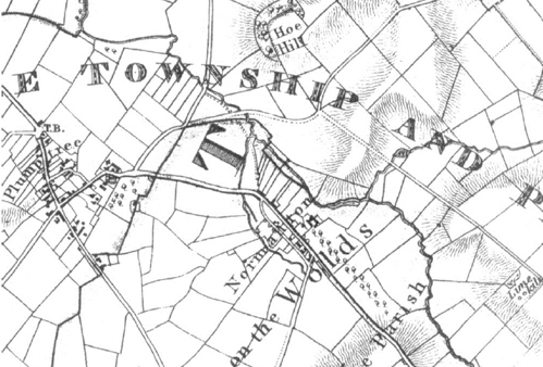
extending south eastwards from Avenue Farm
Pond Bay to the east of the village are clearly shown
Following a period of gradual expansion, the village extended further in the mid-20th century with the development of The Leys, situated between Melton Road and Clipston Road. This residential area reflects typical suburban growth of the time. While it contributes to the overall character of the village as a peaceful and well-maintained area, it does not possess notable architectural or historic interest worthy of conservation via planning controls associated with a Conservation Area.
4 Spatial Analysis
The relationship between open spaces and the built form within a conservation area can be central to its character. This section describes the village’s layout, highlighting the significant views, landmarks and historical focal points. The contribution of open green spaces, trees and other natural elements to the conservation area’s character is also described within this section.
4.1 Plan, Form and Layout
Normanton-on-the-Wolds has a simple linear layout. The main thoroughfare of Old Melton Road was once the principal route between Nottingham and Melton Mowbray before the A606 Plumtree Bypass was built in the early twentieth century to the west of the village.
In the north of the village, Old Melton Road runs in an easterly direction from Plumtree before turning southeast at the small village green. The Road then continues for half a mile before rejoining the A 606.
A second road, Back Lane runs parallel with Old Melton Road through the village centre. Residential properties in Normanton-on-the-Wolds are generally large and set back from the highways behind walls and hedges. There are the odd properties which front the highway. The village’s grandest properties have ranges of outbuildings.
Below is a map that describes the current plan, form and layout of the village/town.
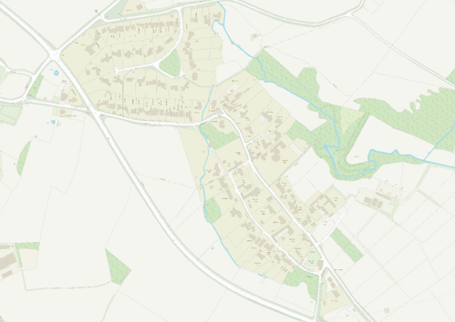
This map is reproduced from Ordnance Survey material with the permission of Ordnance Survey on behalf of the Controller of His Majesty’s Stationary Office © Crown Copyright. Unauthorised reproduction infringes Crown Copyright and may lead to prosecution or civil proceedings.
Rushcliffe Borough Council - 100019419
4.2 Landmarks, Focal Points and Views
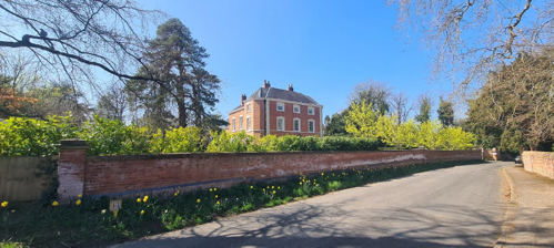
Although the Conservation Area includes a number of grand historic properties, these tend to be partially obscured behind boundary walls and vegetation, rather than dominating the village street.
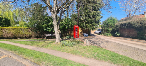
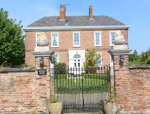
Avenue Farmhouse is perhaps the most visible of these historic properties in its position to the east of Old Melton Road. The village’s two main focal points are the small village green with its red telephone kiosk in the north of the village (see Figure 10) and the Plough Inn Public House (see Figure 23) in the south. Between these two points the subtle curves in Old Melton Road and Back Lane produce some pleasing views of the street scene while views of the open countryside can be appreciated from certain vantage points on the eastern edge of the built-up area.
4.3 Open Spaces, Trees and Landscape
Trees and hedges are a dominant feature throughout the Conservation Area and are key to the maintenance of the enclosed rural feel along the village’s two main roads (see Figure 11). Grass verges also contribute to this rural character, being particularly prominent on the approaches to the village and at the bend in Old Melton Road opposite the Village Green. The remnants of an avenue of trees in the grounds of Avenue Farm are an important historic feature in the landscape to the southeast of the village.
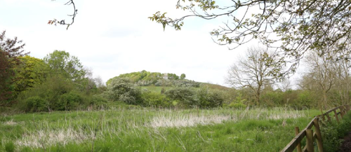
Beyond the built-up area, the site of a medieval water-mill has been formally scheduled; here, the buried earthworks of the mill race, pond and dam lie largely concealed beneath mature trees and scrub, underscoring the importance of maintaining these open, wooded enclosures for both their ecological value and their tangible link to the village’s agricultural heritage.
4.3.1 Open Spaces, Trees and Landscape SWOT Analysis
Strengths - what are the positives of the open spaces, trees, and landscape
- Mature hedgerows, avenue plantings and remnant woodlands create an attractive, seasonally varied landscape.
- A strong verdant character surrounds the village, with extensive paddocks and field margins supporting a range of vegetation.
- Boundary hedges.
- Regular sightings of red deer, muntjac, badgers and foxes underline the ecological value and tranquillity of the setting.
Weaknesses - what are the negatives of the open spaces, trees, and landscape
- Loss of veteran and specimen trees to disease, storm damage or safety-driven felling has eroded the canopy cover in places.
- The absence of a dedicated, publicly accessible open-space focal point means there is no single “green heart” for community gatherings.
Opportunities – what could make the open spaces, trees, and landscape better?
- Formalising regular maintenance plans with private landowners to ensure young and mature trees thrive.
- Extending Tree Preservation Orders to safeguard high-value specimens and ancient hedgerows.
- Introducing community-led planting days or “adopt-a-hedgerow” schemes to bolster local stewardship
Threats - what would make an open spaces, trees and landscape worse?
- Pressure from outward village expansion and new development that could encroach upon surrounding fields and paddocks.
- Incremental loss of historic hedgerows through piecemeal removal or boundary realignments.
- Emerging tree diseases and the impacts of climate change, which may further weaken remaining veteran trees.
Works to Trees
You must contact the Local Planning Authority (LPA), Rushcliffe Borough Council before any works (cutting OR pruning) are carried out to trees within the Normanton-on-the-Wolds Conservation Area.
Six weeks’ notice is required before any works to trees within the Conservation Area is carried out, even if they are not protected by a Tree Preservation Order (TPO).
If there is a tree which undergoes annual maintenance, include this information with the notice. It may be possible, upon agreement with the tree officer, that only one notice is required to cover the future annual maintenance.
Standard notification forms (a section 211 notice), further information and contact details.
A flow chart of the decision-making process regarding works to trees.
4.4 Public Realm
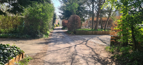
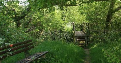
Roads and pavements in Normanton-on-the-Wolds are paved with asphalt but several properties have gravel driveways which create a more informal and rural feel. The village is particularly well connected to the surrounding countryside by a number of footpaths.
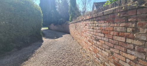
Boundary treatments in the village centre are a mixture of high brick walls and mature hedgerows creating a feeling of enclosure along the highway. There are also less frequent examples of cottages which front directly onto the highway, timber fencing and metal railings.
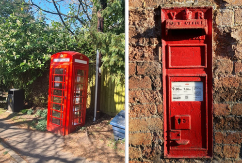
A Victorian wall-mounted post box is located on Back Lane, and a K6 Telephone Kiosk now functioning as a book exchange offering a historical feature that contributes to the village’s period character and visual interest.
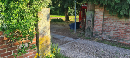
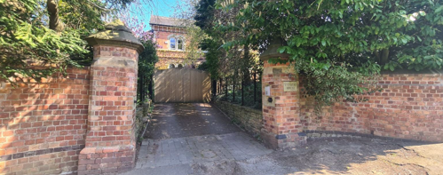
Adjacent to the K6 telephone kiosk is a pair of stone gate piers, which serve as a visual marker of the historic route and enhance the understanding of the village’s evolution and heritage landscape.
House in the background)
5 Buildings of the Conservation Area and Key Characteristics
5.1 Building Types and Activity
The complex pattern of land ownership in Normanton-on-the-Wolds and its development over time has given rise to a rich and diverse built environment, where architectural styles and forms are markedly individualistic, yet collectively contribute to the village’s character and identity.
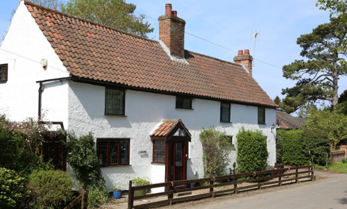
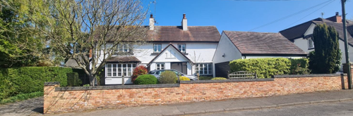
The older buildings in Normanton-on-the-Wolds include two substantial country houses: the Georgian Normanton Grange and Normanton House, a late 16th century farmhouse with later Queen Anne, Georgian, Regency and Victorian additions. Other historic buildings include a Georgian farmhouse with its associated outbuildings (Avenue Farm), an 18th century public house (The Plough Inn), a former Wesleyan Chapel, a number of traditional cottages and a handful of 19th century detached houses.
Many of these buildings can be seen on the historical maps shown in Figure 3.
Despite their differences, the newer buildings complement rather than compete with the village’s historic core. Their individuality echoes the original spirit of aspiration and personal expression that shaped the older properties. The continued architectural variety contributes to a coherent but eclectic townscape, reinforcing the village’s identity as both historically rich and dynamically evolving.
5.1.1 Building Types and Activity SWOT Analysis
Strengths - what activities/places can you go that makes the village/town great?
- A handsome stock of large, well-maintained historic homes that reinforce the village’s character.
- A largely car-free Main Street, preserving attractive sightlines and a sense of openness (excepts around The Plough).
- An extensive network of public footpaths linking the village to the surrounding countryside.
Weaknesses - what activities/places that exist that detract from making the village/town great?
- A concentration of on-street parking around The Plough Inn undermines the quiet, rural setting elsewhere.
- Traffic noise from A606 vehicles intrudes on the tranquillity of the village edge.
- Limited public transport provision restricts access for non-drivers and visitors.
Opportunities - what activities/places could exist that would village/town even better?
- Introduce traffic-calming measures on Old Melton Road (e.g. gateway features, speed cushions) to enhance safety and discourage through-traffic.
- Upgrade road drainage to reduce surface water, improving pedestrian safety and protecting historic kerbing.
- Enhance pedestrian and cycle connectivity (e.g. new stile-free crossings, improved signage) to promote healthier, more active travel.
Threats - what activities/places would village/town worse?
- Further extension of roadside parking—particularly near the pub—could erode the rural character and create congestion.
- Intensification of A606 traffic (or future bypass proposals) exacerbating noise and severance effects.
- Inappropriate roadside development or commercial signage that would detract from the village’s historic appearance.
5.2 Key Characteristics and Building Materials
5.2.1 Building materials and local details
Traditional building materials were largely locally sourced. Bricks for example, were not transported far from where they were made, with most villages having their own brick pit and yard. This lead to interesting village-specific sizes, colours and styles of brickwork. Roofs would have been made from local materials such as thatch until clay pantiles became popular.
The traditional building materials within the Conservation Area are as follows:
Walls: Orange/red brick sometimes embellished with ashlar details or rendered and painted.
Roofs: Orange clay pantiles, red plain tiles or slate. Some decorative ridge tiles. Large properties sometimes have hipped roofs or parapet gables. More modest buildings generally have plain close verge gables where the tiles simply run to the edge of the brick gable but some also have timber barge boards. Brick chimney stacks are positioned either on ridges or gable walls.
Windows: Timber sliding sashes or casement windows in a variety of configurations, with many creating a symmetrical façade and having glazing bars. Several properties have decorative ashlar lintels or window surrounds but simple brick lintels are more common.
Doors:Timber panelled, plank and batten or part glazed varieties. Some properties have decorative fan lights. Porches are common and range from simple brick constructions to timber framed and glazed examples. Door furniture is of iron or brass.
5.2.2 Key Characteristics: Village Centre – Zone 1
Key Characteristics / Architectural Features:
Large detached properties (some of which have ranges of historic outbuildings) set back from the highway with private gardens and a few small cottages. Some suburban style, modern development. Old Main Road thoroughfare characterised by brick walls, hedges and overhanging trees. Courtyard of historic agricultural buildings at Avenue Farm.
Recently planted avenue of Horse Chestnut trees on Old Melton Road.
5.2.3 Key Characteristics: Back Lane – Zone 2
Key Characteristics / Architectural Features:
Large detached properties (some of which have ranges of historic outbuildings) set back from the highway with private gardens and a few small cottages. Some suburban style, modern development. Old Main Road thoroughfare characterised by brick walls, hedges and overhanging trees. Courtyard of historic agricultural buildings at Avenue Farm.
5.2.4 Key Characteristics: Surrounding Paddocks and Pasture – Zone 3
Key Characteristics / Architectural Features:
Small paddocks and fields immediately surrounding the built up area of the village provide a contrast to the enclosed village centre. Ridge and furrow earthworks still visible in the majority of these. Areas of woodland and remains of an historic avenue of Elm trees in the fields south of Avenue Farm.
5.2.5 Key Characteristics: Site off Medieval Water Mill – Zone 4
Key Characteristics / Architectural Features:
Substantial earthworks including mill race, millpond and dam. The site is now mostly shrouded by trees and vegetation.
5.2.6 Key Characteristics SWOT Analysis
Strengths – what is it about the character of the area and most existing buildings that looks good?
- Large, well-maintained historic properties that reinforce local character.
- Traditional Nottinghamshire building styles and materials throughout.
- Hedge and brick-wall boundaries defining plots and enhancing enclosure.
- Mature trees providing a verdant backdrop to the built form.
- Absence of intrusive street lighting preserves rural night-time ambience.
Weaknesses - what is it about the character of the area and most existing buildings that does not look good?
- Overhead pylons and wiring in the southern sector interrupt the skyline.
- Unsympathetic post-war infill along Old Melton Road and Back Lane detracts from historic cohesion.
- Visually intrusive bin-storage at the entrance to Chapel Yard.
- Inappropriate rear extension to Avenue Farm undermining its architectural integrity.
Opportunities - what could make existing buildings (or new builds) look good and contribute to the character of the area?
- Ensure all new developments adopt vernacular proportions, materials and detailing to reinforce the village’s historic character
- Retrofit concealed or underground utilities to remove overhead wiring in sensitive areas
Threats - what could make existing buildings (or new builds) look worse and detract from the character of the area?
- Subdivision of large homes into flats or their conversion to commercial uses (e.g. hotels) risking loss of original fabric and layout.
- Future extensions, infill or replacement of properties with something that disregards local scale, massing and materials.
- Removal of trees, hedges or walls to accommodate new driveways or building footprints.
- Unsympathetic external alterations (windows, doors, porches) eroding the unified character of traditional elevations.
5.3 Listed Buildings
Buildings on the Government’s List of Buildings of Special Architectural or Historic Interest are called “Listed” buildings and are protected by law. Consent is required from Rushcliffe Borough Council before any works of alteration, extension, or demolition can be carried out on any listed building.
Further information can be found in Rushcliffe Borough Council’s publication Listed Buildings in Rushcliffe.
The complete list of the Secretary of State’s Statutory List of Buildings of Special Architectural Interest or Historic Interest can be accessed online.
Names of the Listed Buildings and structures in Normanton-on-the-Wolds Conservation Area (correct as of January 2024) are detailed in Appendix 1. All Listed Buildings are shown on the Townscape Appraisal plan, but some smaller structures such as gravestones may not be shown.
There are four Listed Buildings in the Normanton-on-the-Wolds Conservation Area all of which are Grade 2 listed.
5.4 Key Unlisted Buildings
Contribution to the established character of the place can also come from buildings which are not recognised via listing, or are not old. A plan with all of the positive contributions to the area can be found in Appendix 2 - Conservation Area Boundary and Townscape Appraisal Map.
The Normanton-on-the-Wolds Conservation Area includes a number of unlisted buildings that make a positive contribution to the character and appearance of the Conservation Area. This may be because of their age, architectural style, former function, or general contribution to the variety of the townscape. Key unlisted buildings are highlighted in the Townscape Appraisal in Appendix 2 and some examples of these are shown in the photographs below. However, it is important to stress that nearly all the buildings within a Conservation Area can make a positive contribution to the townscape in some way.
6 Generic Management Plan for Conservation Areas in Rushcliffe
6.1 Introduction
In carrying out its planning functions, the Borough Council is required in law to give special attention to the desirability of preserving or enhancing the character or appearance of Conservation Areas. The Management Plan for a Conservation Area is a tool to ensure the special character of the area is preserved and enhanced. The management plans aim to:
- Outline a strategic management proposal for the preservation and enhancement of the Normanton-on-the-Wolds Conservation Area.
- Act as a guide for professionals and residents alike regarding:
- features of value, worthy of preservation;
- characteristics worthy of preservation;
- opportunities for enhancement;
- development proposals which preserve and enhance the special character of the area.
- Inspire community commitment to conservation principles and reporting.
6.2 National and Local Policies and Guidance
There is a duty to formulate and publish management plans setting out policies and proposals for the preservation and enhancement of Conservation Areas. Many of these policies and proposals are common to all Conservation Areas, and these are set out in this document. The Central Government Guidance and Local policies applicable to Conservation Areas include:
- Rushcliffe Local Plan Part 1: Core Strategy, with a specific focus on:
- Design and Enhancing Local Identity [in part]
- Historic Environment
- Rushcliffe Local Plan Part 2: Development Policies, with a specific focus on:
- Conserving and Enhancing Heritage Assets
- Development Affecting Archaeological Sites
- The National Planning Policy Framework (NPPF), particularly, but not exclusively the chapter on Conserving and Enhancing the Historic Environment.
- The National Planning Practice Guidance (NPPG) (updated 2021 and subject to continual review)
- By Design: Urban Design in the Planning System – Towards Better Practice (2000)
- The Planning (Listed Buildings and Conservation Areas) Act 1990
- Historic England “Historic England Advice Note 1: Conservation Area Designation, Appraisal and Management”
The council will utilise the full range of strategic policy and guidance documents to ensure that development in Normanton-on-the-Wolds Conservation Area is of a standard that enhances the amenity of the local area. The council will always look to use the most up-to-date versions of the document.
Supplementary documents may be issued for individual Conservation Areas where specific policies or proposals are needed.
6.3 Article 4 Directions
There are extra consents required in Conservations Areas. For example, in addition to the general control of development, you will need to get permission for
- Any additions or alterations to the roof (for example, dormer windows)
- The installation of satellite dishes on chimneys, roofs or walls fronting a highway
- Any extension which extends beyond the side of the original dwelling house
- Any extension of more than one storey that extends beyond the rear wall of the original dwelling house
- Cladding the exterior of the dwelling
- Any demolishing of a building or part of a building that has a volume over 115 cubic metres
Article 4 of the Town and Country Planning (General Permitted Development) Order 1995, allows planning authorities to restrict some permitted development rights within particular areas. This does not necessarily prevent development or change taking place but enables the Local Authority to manage the design and detailing of the works, and potentially grant permission subject to appropriate conditions. The use of Article 4 Directions will be proposed where it is considered appropriate following the completion of each Area Appraisal across the Borough.
Details of Article 4 Directions for Normanton-on-the-Wolds Conservation Area
There are currently no Article 4 Directions for Normanton-on-the-Wolds Conservation Area.
6.4 Building Design
Mimicking the local vernacular is not the only way to ‘fit in’ with the character of a conservation area. National policy makes clear that contemporary designed, provided it is sympathetically designed, cannot be dismissed as an option. Therefore, good contemporary design will be encouraged where it respects the context’s character, scale and massing. This must be demonstrated in the Design and Access Statement submitted with any planning application.
Extensions to buildings in Conservation Areas should respect:
- The key characteristics of the original building, including scale, mass, materials and proportions
- The contextual setting and character of the Conservation Area
Copying like for like can devalue and destroy the ability to “read” historic change, and dilutes our historic heritage. Pastiche designs, incorporating poor imitations of other styles, will be resisted, particularly where they incorporate details which are not locally appropriate. Careful high-quality replication may be required in a few very sensitive locations.
In particularly sensitive locations, such as uniform terraces, exact replication may be necessary to maintain compositional unity. In that case, attention to details, choice of materials and high-quality workmanship are the keynotes. However, in some cases, a direct relationship is not impossible. For example, Flemish Bond brickwork cannot be replicated in cavity walls, and narrow lime mortar joints cannot be replicated in modern metric brickwork.
Where a new building is appropriate, on infill sites or where an existing building detracts from the character of the area, the opportunity should be taken to re-establish the streetscape, reinforce enclosure, open up distant vistas or views of landmarks or hide unsightly views.
“New and old buildings can coexist happily without disguising one as the other, if the design of the new is a response to urban design objectives” (DETR – “By Design”, p19).
As with extensions, good contemporary design which respects local character, and the context of the site will be encouraged.
All new buildings should respond appropriately to the existing frontage and normally follow the established building line. Development or redevelopment will normally be resisted if:
“it blocks important views identified in the individual appraisals, uses important open spaces identified in the appraisals, adversely affects the setting of any Listed or key buildings, fails to maintain or re-establish the streetscape where appropriate dominates its Conservation Area background fails to recognise the context of the site destroys important features identified in the individual appraisals such as boundary walls, fences, hedgerows or trees”
Where the quantity of contemporary schemes in a small area becomes significant and outnumbers older buildings within the area, further contemporary schemes could fundamentally shift the architectural character of the area and thus be harmful, even if well designed as an individual project.
New development that stands out from the background of buildings may be appropriate in exceptional circumstances if it contributes positively as a landmark to enhance the street scene, to highlight a corner or to signal a visual change of direction such as along a curving vista.
Any external lighting should be carefully designed and sited to minimise light pollution.
Energy producing or saving devices are generally welcomed by the Council, but careful consideration is required when these are to be located in a Conservation Area and some may require planning permission. In particular, they should be positioned to minimise their impact on the building and on the local amenity.
6.5 Publicity and Knowledge Transfer
Ambiguity about additional controls within a Conservation Area raises the likelihood of inappropriate developments occurring which may damage the integrity of the conservation area designations.
Efforts have been made to engage local community groups in the development and review of the character appraisals. Empowering communities to define the special architectural and historic interest of the Conservation Area aims to raise awareness.
Whether the appraisal took a community-led or a council-led approach, upon reviewing all Conservation Areas, the public were invited to ask questions and comment during a public consultation. A consultation event also aimed to diminish any ambiguity about restrictions within a Conservation Area and increase the likelihood of sensitive and appropriate developments, maintaining the character of the area.
The council recognise the potential issues of turnover in residency and ownership of properties in the conservation area. Therefore, Rushcliffe Borough Council will periodically use their media outlets to highlight conservation area designations and the significant, related planning controls.
The approach taken within Normanton-on-the-Wolds Conservation Area was Council Led
The consultation period took place between the following dates 13/05/2025 – 08/06/2025
The date of the Consultation Event 19/05/2025
If there are any queries about conservation areas, please email conservationareas@rushcliffe.gov.uk
6.6 Public Realm
General maintenance and upkeep to the public realm may include fixing damage to roads and pavements, and fixing issues with street lighting. Issues such as these can impact the quality of the Conservation Area.
The council aims to encourage works to the public realm that are in keeping with, or actively enhance the conservation area. Rushcliffe Borough Council can only advise on work within the public realm that does not require planning permission (for example work completed by statutory undertakers, such as the Highways Authority). In these instances, Rushcliffe borough council cannot prevent such work.
Nottinghamshire County Council are responsible for repairs to roads, pavements and street lighting. Report issues of repairs to roads, pavements and street lighting to Nottinghamshire County Council online.
Rushcliffe Borough Council will continue to undertake their duties in maintaining the public realm. Vandalism, fly tipping and street cleaning are all the responsibility of Rushcliffe Borough Council. Report issues to Rushcliffe Borough Council online.
You must contact the Local Planning Authority (LPA), Rushcliffe Borough Council, before any works (cutting OR pruning) are carried out to trees within the Normanton-on-the-Wolds Conservation Area
Six weeks’ notice is required before any works to trees within the Conservation Area is carried out, even if they are not protected by Tree Preservation Order (TPO).
Standard notification forms (a section 211 notice) - further information and contact details.
A flow chart of the decision-making process regarding works to trees.
6.7 Boundary Treatments
Where there is a proposal for a new boundary treatment to be installed, the council would encourage the use of boundary treatments within the area.
Within conservation areas, planning permission is required to alter, maintain, improve, take down or build any new gate, fence, wall or other enclosure with:
- A height of one metre or more if next to a highway (including a public footpath or bridleway), waterway or open space; or
- A height of two metres or more elsewhere.
Where planning permission is required to remove a wall, Rushcliffe Borough Council will aim to protect those boundary walls and fences that have been identified as positively contributing to the area.
Hedgerows are significant habitats for wildlife in lowland Britain. Regulations are intended to protect important hedges in the countryside. The policy applies to hedges that are more than 20m long, (or less if connected to another hedge) on or adjacent to:
- Land used for agriculture or forestry, including the keeping of horses or donkeys
- Registered common land and village greens
- Local Nature Reserves and Sites of Special Scientific Interest.
The policy does not apply if the hedge is within or on the boundary of the curtilage of a house.
6.8 Buildings at Risk
A few of the important buildings across the various Conservation Areas are currently vacant or not in regular use, which may lead to some being “at risk” of neglect or decay.
The Council will encourage and advise on renovation and repair work that is sensitive to the original or traditional historic character of the building and retains original features. The council will monitor the opportunity and potential for grant aid schemes to encourage the basic maintenance work necessary to ensure that key buildings within the conservation area are structurally sound and weather tight. However, given the current financial climate and outlook, such schemes are unlikely in the short to medium term.
There is a presumption against the demolition of buildings which contribute to the character of the area unless there are exceptional circumstances. It would benefit both the physical form and the function of the Conservation Area if these buildings were repaired, maintained and brought back into use.
Where the poor condition of a building or structure is as a result of neglect and lack of maintenance by its owner there is no requirement for the Borough Council to take its deteriorated condition into account when deciding whether demolition is appropriate. This is to avoid rewarding the deliberate neglect of buildings by representing such action as a way to obtain planning permission for demolition and redevelopment.
6.9 Enforcement
Rushcliffe Borough Council will, from time to time, assess and monitor changes in the appearance and condition of Normanton-on-the-Wolds Conservation Area. This will ensure that where necessary enforcement action can be taken promptly to deal with problems as they arise.
Where co-operation cannot be gained by any other means, Rushcliffe Borough Council has the ability to use additional enforcement powers to tackle particular issues within conservation areas. The Council may take formal action if the condition of any building (listed or unlisted) which makes a positive contribution to the character of the Conservation Area is considered to be at risk.
The council will work in accordance with their enforcement policy, which aims to provide an efficient enforcement service in support of the Council’s statutory planning service. Rushcliffe Borough Council’s enforcement actions will remain transparent, consistent, and proportionate, as it is recognised that effective controls over unauthorised development assists in conserving the natural and built environment whilst helping to protect the quality of people’s lives and maintaining the Council’s integrity.
7 Appendix 1 – Listed Buildings (as of January 2024)
Grade: 2
Listing entry number: 1048999
National grid reference: SK 62296 32777
Location: Normanton Grange and The Mews, Old Melton Road
Outbuilding to the east of Avenue Farmhouse
Grade: 2
Listing entry number: 1373906
National grid reference: SK 62376 32830
Location: Outbuilding to the east of Avenue Farmhouse, Old Melton Road
Avenue Farmhouse and Attached Wall and Gate Piers
Grade: 2
Listing entry number: 1039627
National grid reference: SK 62360 32820
Location: Avenue Farmhouse and attached wall and gate piers, Old Melton Road
Grade: 2
Listing entry number: 1049000
National grid reference: SK 62208 32866
Location: Normanton House, Old Melton Road
*The titles of these listings may not make it clear that all listed buildings always include all attached structures and extensions, regardless of age, and all detached outbuildings built before 1 June 1948 which are, or were at the time of listing, ancillary to the function of the primary listed building and were in the same ownership at the time of listing.
For example, when a house is listed, the listing will apply to extensions, porches, detached historic stables, barns, wash houses, privies etc. Such outbuildings and extensions are only exempt from the provisions of listing where the listing specifically excludes them. Appendix 2 - Conservation Area Boundary and Townscape Appraisal Map.
8 Appendix 2 – Conservation Area Boundary and Townscape Appraisal Map

Map showing the location of:
- Conservation Area boundary - red line
- Listed buildings - red
- Unlisted buildings - purple
- Positive open space - green
- Significant views - red arrows
Conservation Areas
- Bingham Conservation Area
- East Bridgford Conservation Area
- East Leake Conservation Area
- Hawksworth Conservation Area
- Hickling Conservation Area
- Ruddington Conservation Area
- Thoroton Conservation Area
- Wiverton Conservation Area
- Langar Conservation Area
- West Leake Conservation Area
- Whatton in the Vale Conservation Area
- Costock Conservation Area
- Sutton Bonington Conservation Area
- Upper Saxondale Conservation Area
- Wysall Conservation Area
- Bradmore Conservation Area
- Car Colston Conservation Area
- Scarrington Conservation Area
- Orston Conservation Area
- Flintham Conservation Area
- Edwalton Conservation Area
- Aslockton Conservation Area
- Bunny Conservation Area
- Granby Conservation Area
- Keyworth Conservation Area
- Thrumpton Conservation Area
- Normanton on the Wolds Conservation Area
- Upper Broughton Conservation Area
- Kneeton Conservation Area
- Colston Bassett Conservation Area
- Cropwell Bishop Conservation Area