Kneeton Conservation Area
Kneeton Conservation Area Appraisal and Management Plan March 2025
Contents
1.1 Conservation Areas
1.2 The Purpose of a Conservation Area Character Appraisal
1.3 The Planning Policy Context
2 Kneeton Location and Landscape Setting
2.1 The Kneeton Conservation Area
3.1 Location and Historic Activities
3.2 Archaeology
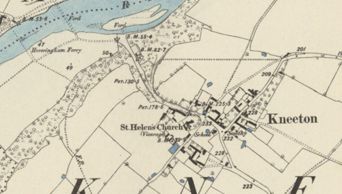
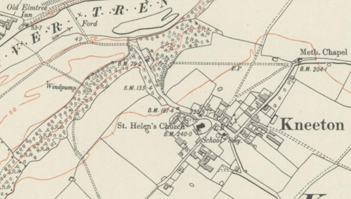
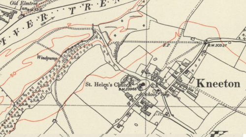
3.3 Historical Mapping
4.1 Plan, Form and Layout
4.2 Landmarks, Focal Points and Views
4.3 Open Spaces, Trees and Landscape
4.3.1 Open Spaces, Trees and Landscape SWOT Analysis
4.4 Public Realm
5 Buildings of the Conservation Area and Key Characteristics
5.1 Building Types and Activity
5.1.1 Building Types and Activity SWOT Analysis
5.2 Key Characteristics and Building Materials
5.2.1 Key Characteristics
5.2.2 Key Characteristics SWOT Analysis
5.3 Listed Buildings
5.4 Key Unlisted Buildings
6.1 Introduction
6.2 National and Local Policies and Guidance
6.3 Article 4 Directions
6.4 Building Design
6.5 Publicity and Knowledge Transfer
6.6 Public Realm
6.7 Boundary Treatments
6.7.1 Walls and Fences
6.7.2 Hedges
6.8 Buildings at risk
6.9 Enforcement
7 Appendix 1 – Listed Buildings (as of March 2025)
8 Appendix 2 – Conservation Area Boundary and Townscape Appraisal Map
1 Introduction
1.1 Conservation Areas
Rushcliffe Borough Council has an obligation under Section 69 of the Planning (Listed Buildings and Conservation Areas) Act 1990 to review, from time to time, its Conservation Area designations.
A Conservation Area, as defined under Section 69, is ‘an area of special architectural or historic interest the character or appearance of which it is desirable to preserve or enhance’.
Kneeton Conservation Area was designated in March 2018, given the recent adoption there have been no previous reviews of the Kneeton Conservation Area or its Character Appraisal.
Section 71 of the Planning (Listed Buildings and Conservation Areas) Act 1990 highlights the local planning authority’s duty to formulate and publish proposals for the preservation and enhancement of the conservation areas. This document, therefore, aims to identify and reaffirm (or redefine) the special architectural or historic interest of the area which warrants its designation.
Conservation Area Appraisals are not, and never have been, tools for to fossilise a place against change, instead, the processes of change which allow places to grow and evolve are recognised as being unavoidable, and it is also recognised that change can be a positive and desirable force. The designation instead allows greater scrutiny and control to manage change to positive effect and to ensure that any changes which require planning permission do not harm, and ideally serve to actively enhance, the existing character of the place.
Kneeton Conservation Area: Summary of Special Interest
Mix of traditional building types and styles in a rural village little affected by modern development.
A positive blend of open spaces and surrounding landscape creates a strong rural character.
1.2 The Purpose of a Conservation Area Character Appraisal
The purpose of a Conservation Area Character Appraisal is to:
- Identify and record the special interest of the Conservation Area to ensure there is public awareness and understanding of what is worthy of preservation.
- To define and reassess current boundaries to accurately reflect what is now perceived to be of special interest.
- To identify opportunities to safeguard and enhance the special interest of the Conservation Area.
It should be noted that the content in this document is not a comprehensive account of every significant building, structure, tree, wall, feature, or space. Therefore, any omission should not be assumed to imply that they are of no interest.
Generally, the character and appearance of a Conservation Area will be preserved or enhanced by:
- Providing controls and regulating development through the planning system.
- Applying the extra controls that designation provides over demolition, minor development, and the protection of trees.
- Environmental enhancement schemes and possibly providing financial assistance for the repair and restoration of specific buildings.
- Encouraging public bodies such as the local highways authority or utility companies to take opportunities to improve the street scene through the appropriate design and sensitive sighting of street furniture (and retention of historic features of interest), or the removal of eyesores and street features that have a negative impact such as overhead wires.
1.3 The Planning Policy Context
This appraisal provides a firm basis on which applications for development within the Kneeton Conservation Area would be assessed. It should be read alongside the wider development plan policy framework produced by Rushcliffe Borough Council and other National Planning Policy Guidance documents. The relevant documents include:
- Rushcliffe Local Plan Part 1: Core Strategy, with a specific focus on:
- Policy 10 (Design and Enhancing Local Identity) [in part]
- Policy 11 (Historic Environment)
- Rushcliffe Local Plan Part 2: Development Policies, with a specific focus on:
- Policy 28 (Conserving and Enhancing Heritage Assets)
- Policy 29 (Development Affecting Archaeological Sites)
- The National Planning Policy Framework (NPPF) (Revised -2021)
- The National Planning Practice Guidance (2015 - Subject to Continual Review)
- By Design: Urban Design in the Planning System – Towards Better Practice (2000)
- The Planning (Listed Buildings and Conservation Areas) Act 1990
Kneeton Conservation Area: Summary of Key Issues
- Redundant buildings, mostly arising from changes in agricultural practices currently detract from local character. Some have been restored and reused since the last version of the character appraisal (2018) but others remain.
- The relocation of farming activity away from the village core presents opportunities but also begins to change the character of the village.
2 Kneeton Location and Landscape Setting
Rushcliffe Borough forms the southern tip of Nottinghamshire, which borders Leicestershire. It is predominantly a rural Borough that contains a mixture of city suburbs, market towns and villages. Rushcliffe is located about half a mile South of Nottingham city centre, with the River Trent forming the majority of its northern boundary and the River Soar defining its western boundary.
The A46 (Fosse Way), a distinctive Roman Road, runs through the centre of the Borough and leads to Newark in the North and Leicester in the South. In the northern half of the Borough, the A52 forms Nottingham’s primary transport link to Grantham and the East of England. Junction 24 of the M1 and East Midlands Airport are located about 1 mile from the western border.
Kneeton today sits in what appears as an isolated ‘dead end’ accessed from either the west through East Bridgford, or direct from a junction of the A46 but with no through routes leading elsewhere. Historically, however, Kneeton was well connected, including via a foot-ferry service which connected it across the Trent to Hoveringham on the north side of the river, a service which survived into the mid-20th century.

2.1 The Kneeton Conservation Area
In its rural location northeast of East Bridgford alongside the River Trent the unaltered nature of Kneeton is a fundamental component of its charm and character. Relatively little growth and relatively little alteration over the past 100 years has combined to give the village a very traditional appearance and a substantial historic interest.
Boundary was slightly expanded in the 2025 review to include a stone, agricultural outbuilding as you enter the village along Bridgford Road.
- Conservation Area Boundary covers: 19.7 hectares (approximate)
- Number of Grade 1 listed buildings: 0
- Number of Grade 2* listed buildings: 0
- Number of Grade 2 listed buildings: 10
A full list of Kneeton Conservation Area’s Listed buildings can be found in Appendix 1. Details accurate as of March 2025.
3 Historical Contexts
3.1 Location and Historic Activities
Recorded in Domesday Book [1086] as “Cheniueton” (later spellings include Kneveton). The village had been granted to Count Alan of Brittany after the Norman Conquest in 1066.
In 1086 the population consisted of 5 tenant farmers, 3 freedmen and 1 priest. In reality this does not equate to 9 people – children and women were not counted so in reality this is likely 8 to 9 households thus somewhere in the region of 32 to 40 people.
The village was a principal manor, which had 2 associated sub-manors nearby. Alan of Brittany held over 1000 manors, either as lord in his own right or as tenant in chief (where he acted as lord but the king retained physical ownership of the land and a right to the profits generated) after 1086 and as such may not have ever visited Kneeton.
At the time of the Domesday Survey only the King and Robert, Count of Mortain, held more land than Alan of Brittany making him one of the most powerful men in England. Alan had extensive lands in Yorkshire and spent the 5 years after 1066 putting down various northern rebellions. After this he was granted the title 1st Lord of Richmond and established Richmond Castle as his principal seat. It is entirely possible that his travels north and south resulted in brief stopovers at his other holdings like Kneeton, but if such visits did happen they were likely brief and infrequent.
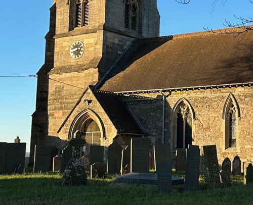
The church sits within a rounded plot; it is possible that the site of the current church has long been used as a place of burial and worship. Other circular and sub-circular churchyards have been recognised as being pre-roman (and in cases where circular churchyards exist on elevated mounds – prehistoric) and as such this churchyard’s distinctive shape may indicate that Kneeton is a very ancient settlement indeed, its position on elevated ground beside a rare fording point of the River Trent would certainly make it a desirable place to settle.
3.2 Archaeology
Kneeton has seen little archaeological investigation, however relatively low density of development should mean that any archaeological remains which do exist could survive in good condition. Given the potentially ancient origins of a settlement at Kneeton there should be high potential for archaeology but the lack of professional investigation means that finds are relatively limited, although the comments in the previous section about the possibly pre-roman origins of the Church site become slightly more intriguing as one of the few finds from the village is a piece of Roman pottery found in the 1960’s.
A 1995 survey of Nottinghamshire Village earthworks also identified features in the paddock opposite the church as signs of potential settlement.
3.3 Historical Mapping
4 Spatial Analysis
The relationship between open spaces and the built form within a conservation area can be central to its character. This section describes the village’s layout, highlighting the significant views, landmarks and historical focal points. The contribution of open green spaces, trees and other natural elements to the conservation area’s character is also described within this section.
4.1 Plan, Form and Layout

This map is reproduced from Ordnance Survey material with the permission of Ordnance Survey on behalf of the Controller of His Majesty’s Stationary Office © Crown Copyright. Unauthorised reproduction infringes Crown Copyright and may lead to prosecution or civil proceedings.
Rushcliffe Borough Council - 100019419
4.2 Landmarks, Focal Points and Views
The core of the village is dominated by open spaces and the junction between Slacks Lane and Main Street. Here the old schoolhouse is one of the few properties found to the south and west side of Main Street its gabled form making it stand out as somewhat different from the cottages opposite.
Vicarage lane runs southwest between the church and an open paddock area, eventually diminishing into a bridleway and footpath beyond The Vicarage which again stands out amongst most other dwellings in the village owing to its high Victorian architectural style. Slacks Lane runs northwards out from the core of the village with a number of houses and farmyards accessed from both sides. The junction of Main Street and Slacks Lane is where the old village smithy sits, with a K6 Telephone kiosk against its southern gable.
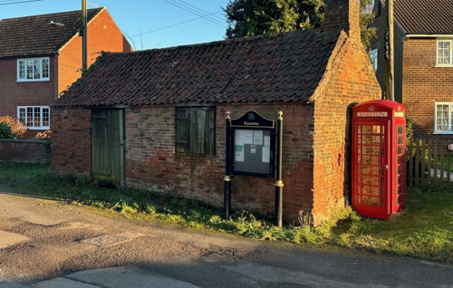
and Slacks Lane alongside the K6 telephone kiosk
The final road of note is that which cuts steeply downwards to the Trent floodplain between Hall Farm and Kneeton House providing a link with the river and the old ferry landing and the location of a historic fording point across the river.
4.3 Open Spaces, Trees and Landscape
The village is centred around open space in the form of a paddock to the southeast of the Church, this open space together with the churchyard of the parish church on its north side creates a focal point at the core of the village.
The route down to the Trent floodplain is a steep trackway in a cutting which is wooded, particularly in its westernmost section. These woods also limit the perception of the Trent and its valley from within the village.
4.3.1 Open Spaces, Trees and Landscape SWOT Analysis
Strengths - what are the positives of the open spaces, trees, and landscape
- Concentration of green space in the core of the village creates a low density rural feel to the heart of Kneeton
- Extensive tree planting and woodland both within the village and between it and the River Trent
Weaknesses - what are the negatives of the open spaces, trees, and landscape
- Much of the tree planting within and around Kneeton is mature with relatively little recent planting taking place
Opportunities – what could make the open spaces, trees, and landscape better?
- New planting, particularly succession planting anticipating the loss of mature trees around the village.
Threats - what would make an open spaces, trees and landscape worse?
- Trees of a number of species are currently facing disease, fungal attach or issue with insects which are having a devastating effect on woodlands, Oak, Ash and Horse Chestnut are particularly vulnerable to current issues
Works to Trees
You must contact the Local Planning Authority (LPA), Rushcliffe Borough Council before any works (cutting OR pruning) are carried out to trees within the Kneeton Conservation Area.
Six weeks’ notice is required before any works to trees within the Conservation Area is carried out, even if they are not protected by a Tree Preservation Order (TPO).
If there is a tree which undergoes annual maintenance, include this information with the notice. It may be possible, upon agreement with the tree officer, that only one notice is required to cover the future annual maintenance.
Standard notification forms (a section 211 notice), further information and contact details.
A flow chart of the decision-making process regarding works to trees.
4.4 Public Realm
Some elements of communications infrastructure including the K6 telephone kiosk and the Victorian wall mounted post box (Smith and Hawkes, of Birmingham), although no more than a century old, have become a quintessential component of the character of the village, and many other villages throughout England.
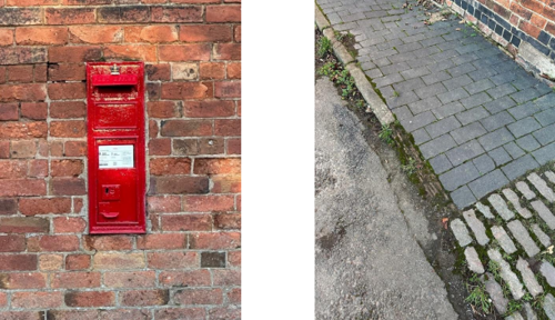
and natural stone curbs
The public realm also gets some unusual materials with the pavements on Main Street being paved in blue brick with natural stone kerbs, where accesses cross the pavement the surfacing changes to stone cobbles. Whilst unusual today it is likely that this form of hard surfacing in the street would not have been uncommon in the past but has simply been superseded elsewhere through modernisations.
5 Buildings of the Conservation Area and Key Characteristics
5.1 Building Types and Activity
As a modest rural village with its basis firmly in agriculture former farmyard complexes and workers cottages make up the majority of the buildings within the village today.
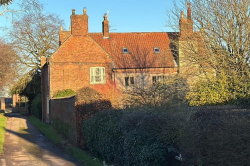
Beyond dwellings there are a number of other buildings including a modest former schoolhouse and the former vicarage both of which are significantly grander and more richly architecturally embellished than the workers cottages, and Kneeton House which remains the residents of the main landowning family in the village.
The village also retains relics of past activities most notably in the form of the old blacksmiths forge which, although disused, has never been put to any other use and still retains some of the original material and equine within.
Most of the agricultural yards are disused, or less intensively used than in the past and two examples, Storeys Yard and Hall Farm Yard have in recent years been the sites of regeneration through the creation of mixed schemes or repair/conversion alongside elements of new build in an agricultural style. The redevelopment at Storeys Yard has been particularly successful, having won awards from the Nottinghamshire Building Conservation Trust although both sites have sought to retain the older buildings and incorporate them into redevelopment of the sites in a way which seeks to retain a degree of agricultural character and form.
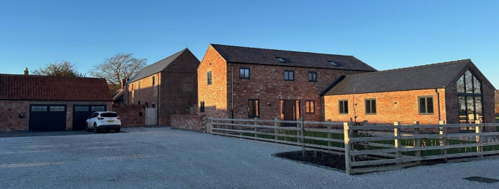
represents a successful recent development which has restored traditional
buildings to use and retained the character of the site
Disused agricultural buildings, and one derelict former farmhouse, continue to be an issue within the village although it is hoped that the successful schemes already brought forward may help to highlight the potential that these other sites have if they were to be brought forward for renovation themselves.
The most obvious is the semi-derelict house along Slack’s Lane. The house itself is of a good size and within a large plot but no apparent progress appears to have been made in terms of repairs, conversion or replacement.
Other buildings are former agricultural buildings unable to meet modern DEFRA standards and unsuitable for storage of modern large agricultural equipment and machinery. These buildings are largely in reasonable condition, and risks to them mostly arise out of their redundant status. Once buildings become redundant there is less incentive for them to be maintained and repaired and redundancy is often the beginning of decline.
Other buildings include the old blacksmiths shop at the junction of Slack’s Lane and Main Street, the north gable end is bowed but appears to have been in this condition for some time, again the building is redundant and vacant. This building poses greater difficulty in that its small size makes finding any future use for the building more challenging. It is understood that the forge survives inside and may be of some interest as a relic of past village life where the local blacksmith would have been an important element of daily life.
5.1.1 Building Types and Activity SWOT Analysis
Strengths - what activities/places exist that makes the village/town great?
Relatively little modern development, and the most recent has successfully integrated with the historic character of the village.
Good examples of traditional rural buildings including blacksmiths forge and field barn which are not common survivals
A good hierarchy of building types from working buildings, through workers cottages onto more elaborate buildings such the The Old Rectory and Kneeton House.
Weaknesses - what activities/places exist that detract from making the village/town great?
A number or vacant / redundant buildings continue to detract from local character owing to their condition.
There are signs of deterioration to the former blacksmiths forge that if unaddressed in the long term could see the building slip into disrepair.
Opportunities - what activities/places could exist that would village/town even better?
A number or vacant / redundant buildings continue to represent obvious opportunities for renovation and reuse.
Threats - what activities/places would make village/town worse?
Changes to farming practise and increasing sizes of equipment and machinery make farm yards within the village increasingly unworkable removing farming activity from the core of the village.
Pressure for new development, however if focused around bringing disused buildings into use and designed to high standards this could be seen as an opportunity.
5.2 Key Characteristics and Building Materials
As is often seen in Southern Nottinghamshire the predominant building material is soft red brick fired from local clay.
There are, usually, several examples of secular buildings built, or partly built, from stone. Examples include Storeys House, the earlier parts of which are largely built from stone, and portions of the side elevation on 3 Kirklands Yard. There is also a modest field barn on the approach into the village entirely constructed of stone. Stone built buildings, other than churches, within Rushcliffe are relatively rare and as such these examples stand out.
rear range, an oddity on secular buildings within Rushcliffe
Beyond buildings there are also several examples of brick boundary walls built onto stone plinths, Storeys House is again an example of this, as is Kneeton House. Again, this is relatively unusual within southern Nottinghamshire, although does seem to be a feature where it is found, rarely occurring as a single example (Cropwell Bishop being a notable example where several such walls exist).
The darkness and feeling of rural isolation at night and the absence of street lighting within the village are considered to be a part of the village’s character, especially in the area around the church and Vicarage Lane.
Perhaps the strongest characteristic of Kneeton is the relative lack of modern development. 20th century development takes the form of either very early development at the very start of the 20th century which still has a high Victorian character (such as The Old Vicarage) or firmly mid 20th century social housing of which there are only 4 examples. The village therefore maintains a highly traditional character which is more sensitive to change than villages which have experienced a greater degree of development through the 20th century. Development at the beginning of the 21st century has focused on redevelopment retaining and reusing existing buildings and adding further structures in a sympathetic manner such that this strong traditional character is being preserved through limited and highly sensitive growth.
Kneeton is a relatively small and compact settlement, and whilst there are a variety of building types and influences from different periods all blend together such that there are not distinct zones of differing character which could be separated out.
Materials:
Walls: Red Brick, some examples on low grey lias type stone plinths.
Roofs: Largely red clay pantiles on agricultural buildings and cottages, although some houses and barns have slate roofs and a small number of the higher status house have clay plain tile, such as Kneeton House.
Windows: Largely timber casements on cottages, although the larger farmhouses and Kneeton House have sashes, although some sash examples have been replaced with unconvincing uPVC ‘sash effect’ casements.
Doors: Largely timber and many examples are simple plank framed and braced doors. Some of the cottages have timber stable style doors.
Key Characteristics / Architectural Features:
Small, compact rural village with a strong traditional character.
Harmonious mix of historic building types and periods, consistent in scale and materials.
Distinctive brick boundary walls on stone plinths (e.g. Storeys House, Kneeton House).
Absence of street lighting reinforces rural isolation, especially near the church and Vicarage Lane.
Minimal modern development; 20th-century housing is limited and sensitively integrated.
Recent changes focus on reuse and sympathetic adaptation of existing buildings.
5.2.2 Key Characteristics SWOT Analysis
Strengths – what is good about most existing buildings that looks good?
- Limited development post 1915 retaining a strong traditional character
- Older properties broadly retain a traditional palete of building materials, including to roofs and windows
- Most occupied properties are well cared for
Weaknesses – what is not so good about most existing buildings that does not look good?
- Nothing listed
Opportunities – what could make existing buildings (or new builds) look good and contribute to the character of the area?
- A number or vacant / redundant buildings continue to represent obvious opportunities for renovation and reuse.
Threats – what could make existing buildings (or new builds) look worse and detract from the character of the area?
- Nothing listed
5.3 Listed Buildings
Buildings on the Government’s List of Buildings of Special Architectural or Historic Interest are called “Listed” buildings and are protected by law. Consent is required from Rushcliffe Borough Council before any works of alteration, extension, or demolition can be carried out on any listed building.
Further information can be found in Rushcliffe Borough Council’s publication Listed Buildings in Rushcliffe.
The complete list of the Secretary of State’s Statutory List of Buildings of Special Architectural Interest or Historic Interest can be accessed online.
Names and photos of the Listed Buildings and structures in Kneeton Conservation Area (correct as of January 2025) are detailed in Appendix 1. All Listed Buildings are shown on the Townscape Appraisal plan, but some smaller structures such as gravestones may not be shown.
5.4 Key Unlisted Buildings
Contribution to the established character of the place can also come from buildings which are not recognised via listing, or are not old. A plan with all of the positive contributions to the area can be found in Appendix 2 - Conservation Area Boundary and Townscape Appraisal Map.
6 Generic Management Plan for Conservation Areas in Rushcliffe
6.1 Introduction
In carrying out its planning functions, the Borough Council is required in law to give special attention to the desirability of preserving or enhancing the character or appearance of Conservation Areas. The Management Plan for a Conservation Area is a tool to ensure the special character of the area is preserved and enhanced. The management plans aim to:
- Outline a strategic management proposal for the preservation and enhancement of the Kneeton Conservation Area.
- Act as a guide for professionals and residents alike regarding:
- features of value, worthy of preservation;
- characteristics worthy of preservation;
- opportunities for enhancement;
- development proposals which preserve and enhance the special character of the area.
- Inspire community commitment to conservation principles and reporting.
6.2 National and Local Policies and Guidance
There is a duty to formulate and publish management plans setting out policies and proposals for the preservation and enhancement of Conservation Areas. Many of these policies and proposals are common to all Conservation Areas, and these are set out in this document. The Central Government Guidance and Local policies applicable to Conservation Areas include:
- Rushcliffe Local Plan Part 1: Core Strategy, with a specific focus on:
- Design and Enhancing Local Identity [in part]
- Historic Environment
- Rushcliffe Local Plan Part 2: Development Policies, with a specific focus on:
- Conserving and Enhancing Heritage Assets
- Development Affecting Archaeological Sites
- The National Planning Policy Framework (NPPF), particularly, but not exclusively the chapter on Conserving and Enhancing the Historic Environment.
- The National Planning Practice Guidance (NPPG) (updated 2021 and subject to continual review)
- By Design: Urban Design in the Planning System – Towards Better Practice (2000)
- The Planning (Listed Buildings and Conservation Areas) Act 1990
- Historic England “Historic England Advice Note 1: Conservation Area Designation, Appraisal and Management”
The council will utilise the full range of strategic policy and guidance documents to ensure that development in Kneeton Conservation Area is of a standard that enhances the amenity of the local area. The council will always look to use the most up-to-date versions of the document.
Supplementary documents may be issued for individual Conservation Areas where specific policies or proposals are needed.
6.3 Article 4 Directions
There are extra consents required in Conservation Areas. For example, in addition to the general control of development, you will need to get permission for
- Any additions or alterations to the roof (for example, dormer windows)
- The installation of satellite dishes on chimneys, roofs or walls fronting a highway
- Any extension which extends beyond the side of the original dwelling house
- Any extension of more than one storey that extends beyond the rear wall of the original dwelling house
- Cladding the exterior of the dwelling
- Any demolishing of a building or part of a building that has a volume over 115 cubic metres
Article 4 of the Town and Country Planning (General Permitted Development) Order 1995, allows planning authorities to restrict some permitted development rights within particular areas. This does not necessarily prevent development or change taking place but enables the Local Authority to manage the design and detailing of the works, and potentially grant permission subject to appropriate conditions. The use of Article 4 Directions will be proposed where it is considered appropriate following the completion of each Area Appraisal across the Borough.
Details of Article 4 Directions for Kneeton Conservation Area
There are currently no Article 4 Directions for Kneeton Conservation Area.
6.4 Building Design
Mimicking the local vernacular is not the only way to ‘fit in’ with the character of a conservation area. National policy makes clear that contemporary designed, provided it is sympathetically designed, cannot be dismissed as an option. Therefore, good contemporary design will be encouraged where it respects the context’s character, scale and massing. This must be demonstrated in the Design and Access Statement submitted with any planning application.
Extensions to buildings in Conservation Areas should respect:
- The key characteristics of the original building, including scale, mass, materials and proportions
- The contextual setting and character of the Conservation Area
Copying like for like can devalue and destroy the ability to “read” historic change, and dilutes our historic heritage. Pastiche designs, incorporating poor imitations of other styles, will be resisted, particularly where they incorporate details which are not locally appropriate. Careful high-quality replication may be required in a few very sensitive locations.
In particularly sensitive locations, such as uniform terraces, exact replication may be necessary to maintain compositional unity. In that case, attention to details, choice of materials and high-quality workmanship are the keynotes. However, in some cases, a direct relationship is not impossible. For example, Flemish Bond brickwork cannot be replicated in cavity walls, and narrow lime mortar joints cannot be replicated in modern metric brickwork.
Where a new building is appropriate, on infill sites or where an existing building detracts from the character of the area, the opportunity should be taken to re-establish the streetscape, reinforce enclosure, open up distant vistas or views of landmarks or hide unsightly views.
“New and old buildings can coexist happily without disguising one as the other, if the design of the new is a response to urban design objectives” (DETR – “By Design”, p19).
As with extensions, good contemporary design which respects local character, and the context of the site will be encouraged.
All new buildings should respond appropriately to the existing frontage and normally follow the established building line. Development or redevelopment will normally be resisted if:
“it blocks important views identified in the individual appraisals, uses important open spaces identified in the appraisals, adversely affects the setting of any Listed or key buildings, fails to maintain or re-establish the streetscape where appropriate dominates its Conservation Area background fails to recognise the context of the site destroys important features identified in the individual appraisals such as boundary walls, fences, hedgerows or trees”
Where the quantity of contemporary schemes in a small area becomes significant and outnumbers older buildings within the area, further contemporary schemes could fundamentally shift the architectural character of the area and thus be harmful, even if well designed as an individual project.
New development that stands out from the background of buildings may be appropriate in exceptional circumstances if it contributes positively as a landmark to enhance the street scene, to highlight a corner or to signal a visual change of direction such as along a curving vista.
Any external lighting should be carefully designed and sited to minimise light pollution. Energy producing or saving devices are generally welcomed by the Council, but careful consideration is required when these are to be located in a Conservation Area and some may require planning permission. In particular, they should be positioned to minimise their impact on the building and on the local amenity.
6.5 Publicity and Knowledge Transfer
Ambiguity about additional controls within a Conservation Area raises the likelihood of inappropriate developments occurring which may damage the integrity of the conservation area designations.
Efforts have been made to engage local community groups in the development and review of the character appraisals. Empowering communities to define the special architectural and historic interest of the Conservation Area aims to raise awareness.
Whether the appraisal took a community-led or a council-led approach, upon reviewing all Conservation Areas, the public were invited to ask questions and comment during a public consultation. A consultation event also aimed to diminish any ambiguity about restrictions within a Conservation Area and increase the likelihood of sensitive and appropriate developments, maintaining the character of the area.
The council recognise the potential issues of turnover in residency and ownership of properties in the conservation area. Therefore, Rushcliffe Borough Council will periodically use their media outlets to highlight conservation area designations and the significant, related planning controls.
The approach taken within Kneeton Conservation Area was a Council Led review.
The consultation period took place between the following dates 04/06/2025 – 26/06/2025
The date of the Consultation Event 18/06/2025
If there are any queries about conservation areas, please email conservationareas@rushcliffe.gov.uk
6.6 Public Realm
General maintenance and upkeep to the public realm may include fixing damage to roads and pavements, and fixing issues with street lighting. Issues such as these can impact the quality of the Conservation Area.
The council aims to encourage works to the public realm that are in keeping with, or actively enhance the conservation area. Rushcliffe Borough Council can only advise on work within the public realm that does not require planning permission (for example work completed by statutory undertakers, such as the Highways Authority). In these instances, Rushcliffe borough council cannot prevent such work.
Nottinghamshire County Council are responsible for repairs to roads, pavements and street lighting. Report issues of repairs to roads, pavements and street lighting to Nottinghamshire County Council online.
Rushcliffe Borough Council will continue to undertake their duties in maintaining the public realm. Vandalism, fly tipping and street cleaning are all the responsibility of Rushcliffe Borough Council. Report issues to Rushcliffe Borough Council online.
You must contact the Local Planning Authority (LPA), Rushcliffe Borough Council, before any works (cutting OR pruning) are carried out to trees within the Kneeton Conservation Area
Six weeks’ notice is required before any works to trees within the Conservation Area is carried out, even if they are not protected by Tree Preservation Order (TPO).
Standard notification forms (a section 211 notice) - further information and contact details.
A flow chart of the decision-making process regarding works to trees.
6.7 Boundary Treatments
Where there is a proposal for a new boundary treatment to be installed, the council would encourage the use of boundary treatments within the area.
Within conservation areas, planning permission is required to alter, maintain, improve, take down or build any new gate, fence, wall or other enclosure with:
- A height of one metre or more if next to a highway (including a public footpath or bridleway), waterway or open space; or
- A height of two metres or more elsewhere.
Where planning permission is required to remove a wall, Rushcliffe Borough Council will aim to protect those boundary walls and fences that have been identified as positively contributing to the area.
Hedgerows are significant habitats for wildlife in lowland Britain. Regulations are intended to protect important hedges in the countryside. The policy applies to hedges that are more than 20 metres long, (or less if connected to another hedge) on or adjacent to:
- Land used for agriculture or forestry, including the keeping of horses or donkeys
- Registered common land and village greens
- Local Nature Reserves and Sites of Special Scientific Interest.
The policy does not apply if the hedge is within or on the boundary of the curtilage of a house.
6.8 Buildings at Risk
A few of the important buildings across the various Conservation Areas are currently vacant or not in regular use, which may lead to some being “at risk” of neglect or decay.
The Council will encourage and advise on renovation and repair work that is sensitive to the original or traditional historic character of the building and retains original features. The council will monitor the opportunity and potential for grant aid schemes to encourage the basic maintenance work necessary to ensure that key buildings within the conservation area are structurally sound and weather tight. However, given the current financial climate and outlook, such schemes are unlikely in the short to medium term.
There is a presumption against the demolition of buildings which contribute to the character of the area unless there are exceptional circumstances. It would benefit both the physical form and the function of the Conservation Area if these buildings were repaired, maintained and brought back into use.
Where the poor condition of a building or structure is as a result of neglect and lack of maintenance by its owner there is no requirement for the Borough Council to take its deteriorated condition into account when deciding whether demolition is appropriate. This is to avoid rewarding the deliberate neglect of buildings by representing such action as a way to obtain planning permission for demolition and redevelopment.
6.9 Enforcement
Rushcliffe Borough Council will, from time to time, assess and monitor changes in the appearance and condition of Kneeton Conservation Area. This will ensure that where necessary enforcement action can be taken promptly to deal with problems as they arise.
Where co-operation cannot be gained by any other means, Rushcliffe Borough Council has the ability to use additional enforcement powers to tackle particular issues within conservation areas. The Council may take formal action if the condition of any building (listed or unlisted) which makes a positive contribution to the character of the Conservation Area is considered to be at risk.
The council will work in accordance with their enforcement policy, which aims to provide an efficient enforcement service in support of the Council’s statutory planning service. Rushcliffe Borough Council’s enforcement actions will remain transparent, consistent, and proportionate, as it is recognised that effective controls over unauthorised development assists in conserving the natural and built environment whilst helping to protect the quality of people’s lives and maintaining the Council’s integrity.
7 Appendix 1 – Listed Buildings (as of January 2025)
Group of 3 Headstones Adjoining South Wall of Nave at Church of St Helen
Grade: 2
Listing entry number: 1243800
National grid reference: SK 70985 46096
Location: Group of 3 Headstones Adjoining South Wall of Nave at Church of St Helen, Church Lane
Hall Farmhouse and Attached Wash House
Grade: 2
Listing entry number: 1243801
National grid reference: SK 70896 46116
Location: Hall Farmhouse and Attached Wash House, Main Street
Grade: 2
Listing entry number: 1243802
National grid reference: SK 70931 46131
Location: Barn at Hall Farm, Main Street
Grade: 2
Listing entry number: 1243803
National grid reference: SK 71000 46154
Location: Neale's Farmhouse, Main Street
Grade: 2
Listing entry number: 1243804
National grid reference: SK 71068 46095
Location: 3, Main Street
Number 4 (Mayfield Cottage) and Corner Cottage
Grade: 2
Listing entry number: 1243805
National grid reference: SK 71079 46085
Location: Number 4 (Mayfield Cottage) and Corner Cottage
Grade: 2
Listing entry number: 1272706
National grid reference: SK 70982 46097
Location: Church of St Helen, Church Lane
Old Vicarage and Boundary Wall
Grade: 2
Listing entry number: 1272707
National grid reference: SK 70960 46010
Location: Old Vicarage And Boundary Wall, Church Lane
Barn and Adjoining Stable at Hall Farm
Grade: 2
Listing entry number: 1272708
National grid reference: SK 70957 46127
Location: Barn and Adjoining Stable at Hall Farm, Main Street
Numbers 1 and 2 Kirklands Yard and Adjoining Barn and Stables
Grade: 2
Listing entry number: 1272709
National grid reference: SK 71066 46108
Location: Numbers 1 and 2 Kirklands Yard and Adjoining Barn and Stables, Main Street
*The titles of these listings may not make it clear that all listed buildings always include all attached structures and extensions, regardless of age, and all detached outbuildings built before 1 June 1948 which are, or were at the time of listing, ancillary to the function of the primary listed building and were in the same ownership at the time of listing.
For example, when a house is listed, the listing will apply to extensions, porches, detached historic stables, barns, wash houses, privies etc. Such outbuildings and extensions are only exempt from the provisions of listing where the listing specifically excludes them. Appendix 2 - Conservation Area Boundary and Townscape Appraisal Map.
8 Appendix 2 – Conservation Area Boundary and Townscape Appraisal Map
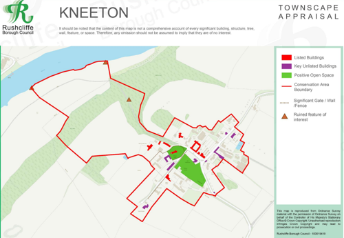
Map showing the location of:
- Conservation Area boundary - red line
- Listed buildings - red
- Unlisted buildings - purple
- Positive open space - green
- Significant views - red arrows
Conservation Areas
- Bingham Conservation Area
- East Bridgford Conservation Area
- East Leake Conservation Area
- Hawksworth Conservation Area
- Hickling Conservation Area
- Ruddington Conservation Area
- Thoroton Conservation Area
- Wiverton Conservation Area
- Langar Conservation Area
- West Leake Conservation Area
- Whatton in the Vale Conservation Area
- Costock Conservation Area
- Sutton Bonington Conservation Area
- Upper Saxondale Conservation Area
- Wysall Conservation Area
- Bradmore Conservation Area
- Car Colston Conservation Area
- Scarrington Conservation Area
- Orston Conservation Area
- Flintham Conservation Area
- Edwalton Conservation Area
- Aslockton Conservation Area
- Bunny Conservation Area
- Granby Conservation Area
- Keyworth Conservation Area
- Thrumpton Conservation Area
- Normanton on the Wolds Conservation Area
- Upper Broughton Conservation Area
- Kneeton Conservation Area
- Colston Bassett Conservation Area
- Cropwell Bishop Conservation Area