Bunny Conservation Area
Bunny Conservation Area Appraisal and Management Plan January 2025

Contents
1.1 Conservation Areas
1.2 The Purpose of a Conservation Area Character Appraisal
1.3 The Planning Policy Context
2 Bunny Location and Landscape Setting
2.1 The Bunny Conservation Area
3.1 Historical Overview
3.2 Location and Historic Activities
3.3 Historical Mapping
4.1 Plan, Form and Layout
4.2 Landmarks, Focal Points and Views
4.3 Open Spaces, Trees and Landscape
4.4 Public Realm
5 Buildings of the Conservation Area and Key Characteristics
5.1 Building Types and Activity
5.1.1 Building Types and Activity SWOT Analysis
5.2 Key Characteristics and Building Materials
5.2.1 Building Details
5.2.2 Key Characteristics: The village centre (Zone 1)
5.2.3 Key Characteristics: Bunny Hall (Zone 2)
5.2.4 Key Characteristics: Main Street (Zone 3)
5.2.5 Key Characteristics: Moor Lane (Zone 4)
5.2.6 Key Characteristics: Loughborough Road (Zone 5)
5.2.7 Key Characteristics: The village centre (Zone 6)
5.2.8 Key Characteristics: SWOT Analysis
5.3 Listed Buildings
5.4 Key Unlisted Buildings
6.1 Introduction
6.2 National and Local Policies and Guidance
6.3 Article 4 Directions
6.4 Building Design
6.5 Publicity and Knowledge Transfer
6.6 Public Realm
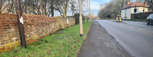
6.7 Boundary Treatments
6.7.1 Walls and Fences
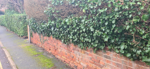
6.7.2 Hedges
6.8 Buildings at risk
6.9 Enforcement
7 Appendix 1 – Listed Buildings (as of March 2025)
8 Appendix 2 – Conservation Area Boundary and Townscape Appraisal Map
1 Introduction
1.1 Conservation Areas
Rushcliffe Borough Council has an obligation under Section 69 of the Planning (Listed Buildings and Conservation Areas) Act 1990 to review, from time to time, its Conservation Area designations.
A Conservation Area, as defined under Section 69, is ‘an area of special architectural or historic interest the character or appearance of which it is desirable to preserve or enhance’.
Bunny Conservation Area was designated in 1976. Prior to this reappraisal of 2025, the Bunny Conservation Area was reviewed in 2009.
Section 71 of the Planning (Listed Buildings and Conservation Areas) Act 1990 highlights the local planning authority’s duty to formulate and publish proposals for the preservation and enhancement of the conservation areas. This document, therefore, aims to identify and
reaffirm (or redefine) the special architectural or historic interest of the area which warrants its designation.
Conservation Area Appraisals are not, and never have been, tools for to fossilise a place against change, instead, the processes of change which allow places to grow and evolve are recognised as being unavoidable, and it is also recognised that change can be a positive and desirable force. The designation instead allows greater scrutiny and control to manage change to positive effect and to ensure that any changes which require planning permission do not harm, and ideally serve to actively enhance, the existing character of the place.
Bunny Conservation Area: Summary of Special Interest
- Mixed rural and suburban character in terms of architecture, landscape and boundary treatments.
- The churchyard of the 14th-15th century Parish Church of St Mary provides the village with an attractive open space at its
centre. - Collection of 18th century buildings (including the imposing Bunny Hall) built to Sir Thomas Parkyns’ designs.
- Backdrop of arable farmland and paddocks.
- Views out to surrounding countryside from the fringes of the village.
- Strong rural approaches into village with grass verges and groups of mature trees.
- Boundary treatments include traditional red brick walls and hedge lines.
1.2 The Purpose of a Conservation Area Character Appraisal
The purpose of a Conservation Area Character Appraisal is to:
- Identify and record the special interest of the Conservation Area to ensure there is public awareness and understanding of what is
worthy of preservation. - To define and reassess current boundaries to accurately reflect what is now perceived to be of special interest.
- To identify opportunities to safeguard and enhance the special interest of the Conservation Area.
It should be noted that the content in this document is not a comprehensive account of every significant building, structure, tree, wall, feature, or space. Therefore, any omission should not be assumed to imply that they are of no interest.
Generally, the character and appearance of a Conservation Area will be preserved or enhanced by:
- Providing controls and regulating development through the planning system.
- Applying the extra controls that designation provides over demolition, minor development, and the protection of trees.
- Environmental enhancement schemes and possibly providing financial assistance for the repair and restoration of specific buildings.
- Encouraging public bodies such as the local highways authority or utility companies to take opportunities to improve the street scene through the appropriate design and sensitive sighting of street furniture (and retention of historic features of interest), or the removal of eyesores and street features that have a negative impact such as overhead wires.
1.3 The Planning Policy Context
This appraisal provides a firm basis on which applications for development within the xxxxxx Conservation Area would be
assessed. It should be read alongside the wider development plan policy framework produced by Rushcliffe Borough Council and other
National Planning Policy Guidance documents. The relevant documents include:
- Rushcliffe Local Plan Part 1: Core Strategy, with a specific focus on:
- Policy 10 (Design and Enhancing Local Identity) [in part]
- Policy 11 (Historic Environment)
- Rushcliffe Local Plan Part 2: Development Policies, with a specific focus on:
- Policy 28 (Conserving and Enhancing Heritage Assets)
- Policy 29 (Development Affecting Archaeological Sites)
- The National Planning Policy Framework (NPPF) (Revised -2021)
- The National Planning Practice Guidance (2015 - Subject to Continual Review)
- By Design: Urban Design in the Planning System – Towards Better Practice (2000)
- The Planning (Listed Buildings and Conservation Areas) Act 1990
Bunny Conservation Area: Summary of Key Issues
- Alterations to Listed and key unlisted properties - Unsympathetic alterations such as porches and other extensions, dormer windows, and uPVC windows can have a potentially damaging effect on the village’s character.
- Boundary treatments – Many hedges have been replaced with close boarded timber fencing which is not in sympathy with the
village’s rural character. - Development Pressures - Potential pressure for unsympathetic housing development at redundant farms along Moor Lane and Main Street and paddocks on the outskirts of the village.
- Highways and Transportation - Speeding traffic and traffic volume along Loughborough Road causes issues with pedestrian safety, noise and pollution.
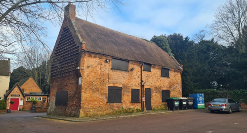
- Buildings at risk - Cottage in the grounds of the Rancliffe Arms Public House remains on Nottinghamshire County Council’s Buildings at Risk Register.
2 Bunny Location and Landscape Setting
Rushcliffe Borough forms the southern tip of Nottinghamshire, which borders Leicestershire. It is predominantly a rural Borough that contains a mixture of city suburbs, market towns and villages. Rushcliffe is located about half a mile South of Nottingham city centre, with the River Trent forming the majority of its northern boundary and the River Soar defining its western boundary.
The A46 (Fosse Way), a distinctive Roman Road, runs through the centre of the Borough and leads to Newark in the North and Leicester in the South. In the northern half of the Borough, the A52 forms Nottingham’s primary transport link to Grantham and the East of England. Junction 24 of the M1 and East Midlands Airport are located about 1 mile from the western border.
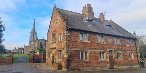
Bunny is a small village located in the south of the borough of Rushcliffe, Nottinghamshire. Positioned to the east of the A60 road, it is situated about 7 miles to the south of Nottingham city centre and approximately 4 miles north of the town of Loughborough in Leicestershire. Bunny is also close to the neighbouring village of Bradmore, which lies to the north of Bunny. The village is surrounded by rolling countryside, with its historic core and notable landmarks such as St Mary's Church and Bunny Hall nestled within this rural setting.

2.1 The Bunny Conservation Area
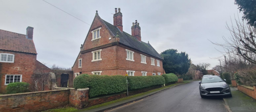
The historic core of Bunny is a small, compact settlement cantered around its large 14th and 15th century church of St Mary, which is a Grade I Listed Building. This area is rich in architectural and historical significance, particularly related to the Parkyns family. Sir Thomas Parkyns (1662-1741), a prominent figure of the time, was responsible for designing and constructing numerous houses and barns in Bunny and the surrounding villages, such as Bradmore, during the early 1700s. One of his most notable creations is Bunny Hall, originally known as Crazy Hall, which he rebuilt in 1720. This building showcases his distinctive, eccentric architectural style.
In addition to Bunny Hall, Sir Thomas Parkyns was behind the construction of more traditional red-brick buildings, such as The Old Vicarage, Ivy Cottage, the Rancliffe Arms public house, the Post Office, and the former Schoolhouse on Loughborough Road. His influence also extended to the restoration of the parish church, which he oversaw in 1718.
- Conservation Area Boundary covers: 27.2 hectares (approximate)
- Number of Grade I listed buildings: 2
- Number of Grade II* listed buildings: 2
- Number of Grade II listed buildings: 21
A full list of Bunny Conservation Area’s Listed buildings can be found in Appendix 1.
3 Historical Contexts
3.1 Location and Historic Activities
The earliest written records of Bunny date from the reign of Edward the Confessor (1003–1066), when the parish was owned by a Saxon named Levenot. By the 13th and 14th centuries, the village was known to feature a hermit’s meadow and a common bakehouse.
The landscape of Bunny at this time would have been typical of a Midland open-field village, with land farmed under a strip-farming system, where fields were divided into strips and shared among local farmers. Evidence of this system can still be seen in the remains of ridge and furrow fields visible from Loughborough Road.
The village continued to evolve throughout the centuries, with the name "Bune," meaning "reed" in Saxon, eventually becoming Bunny by the 18th century. Its early importance is evident in the Domesday Book of 1086, which records a church, a priest, land for ploughing, and a mill. By the 14th century, Bunny was embroiled in disputes over land and tithes with ecclesiastical bodies, such as Lenton and Ulverscroft Priories.
The Black Death had an impact on the village, delaying construction and prompting repairs to the parish church, which is believed to have existed before 1354.
The houses of the villagers were strung along the two streets which comprise the main part of the old village (Moor Lane and Main Street). Bunny Park and pasture extended eastwards, whilst south of the village were the Nether, Middle and Upper fields, ascending to the Old Wood and the hills of the Wolds. Woodland areas around the village provided the people with fuel, wood for their buildings, furniture and tools, and food for their free-range pigs.
On the west side lay a poorly drained marshy area, probably used for grazing in summer and hay in winter. It was also a useful source of fish, wild fowl and a harvest of osiers and willows, which provided thatch for buildings and material for fencing and basket making. How much land was encompassed by Bunny and Bradmore can be accurately assessed when in 1627, a postmortem following the death of George Parkyns stated that there were 1120 acres of land at Bunny and 630 at Bradmore. Population estimates put the number of people in 1603 at around 448.
The Parkyns family played a significant role in shaping Bunny’s identity from the late 16th century onwards. Richard Parkyns, a barrister and Recorder of Nottingham, purchased the manor in 1596, and his descendants, notably Colonel Isham Parkyns, were staunch Royalists during the English Civil Wars. Bunny Hall became a refuge for Royalist figures, including Prince Rupert and Queen Henrietta Maria, during the conflict. In 1627, the death of George Parkyns revealed the extent of the family's landholdings, which included
1,120 acres in Bunny and 630 acres in nearby Bradmore.
Sir Thomas Parkyns, known as the "wrestling baronet," left a lasting architectural legacy. His eccentric designs included the rebuilding of Bunny Hall in 1720, which remains a striking example of his style. Sir Thomas also supervised the restoration of the parish church in 1718 and contributed to the construction of several buildings in the village and surrounding areas, including the Old Vicarage, Ivy Cottage, the Rancliffe Arms public house, and the former schoolhouse on Loughborough Road.
By the 19th century, Bunny had become a primarily agricultural community, with farming serving as the main occupation for most villagers. However, as new agricultural methods were introduced, the number of individual farms declined. Despite this, the population of Bunny remained relatively stable, and the village saw only minimal expansion in terms of area. The community's architectural heritage, such as the church and Bunny Hall, continued to shape the village's identity, with ongoing efforts to preserve these historic
structures, including bell repairs in 1955 and the installation of stained-glass windows.
3.2 Archaeology
It is believed that the valley in which Bunny sits was carved during the Ice Age, with glacial sand deposits visible in the path of the Fairham Brook. Fossils found in the area, including oyster shells and horse teeth from the Pleistocene era, provide a glimpse into ancient ecosystems that existed long before human settlement.
Archaeological finds further reveal the area’s historical significance. Roman artefacts, such as a First Century bowl discovered in 1947 during construction on Loughborough Road, and the remains of a Roman well uncovered in 1967 on Bunny Hill, demonstrate the continued human presence from the Roman occupation, which lasted from 43 AD to 410 AD. The contents of the well, dated between 100 and 300 AD, were carefully analysed and dated between 100 to 300 AD.
3.3 Historical Mapping
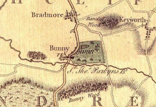
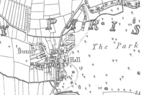
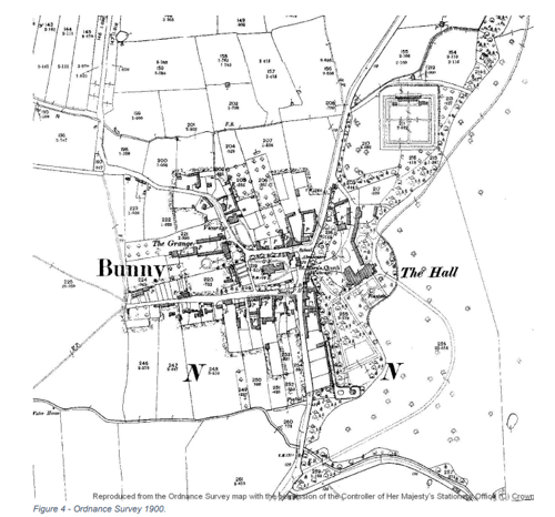
4 Spatial Analysis
The relationship between open spaces and the built form within a conservation area can be central to its character. This section describes the village’s layout, highlighting the significant views, landmarks and historical focal points. The contribution of open green spaces, trees and other natural elements to the conservation area’s character is also described within this section.
4.1 Plan, Form and Layout
Bunny’s layout is quite compact, characterised by its nucleated settlement pattern around the almost square-shaped churchyard of St. Mary’s. The village's layout reflects its medieval origins and subsequent developments, particularly those influenced by the Parkyns family in the 18th century.
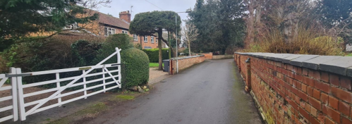
To the east of the Church lies Loughborough Road, also known as the A60 which is a major north-south route. Church Street borders the churchyard on the north and west sides, and intersects with the Loughborough Road to the northeast. While Moor Lane extends diagonally outward from the northwest corner of Church Street. Main Street runs east-west for about 300 yards from Loughborough Road, forming the southern edge of the churchyard.
Residential development is primarily concentrated along Main Street, Moor Lane, and the southern stretch of Loughborough Road. Moor View, a private residential cul-de-sac branching off Moor Lane, features a mix of detached and semi-detached homes, many with enclosed gardens, driveways, and garages. Residents here benefit from access to a private green space and a pond area, enhancing the area's appeal.
To the east of Loughborough Road, the landscape transitions into parkland and woodland dominated by Bunny Hall and its associated outbuildings. This area underscores the historical significance of the Parkyns family, particularly Sir Thomas Parkyns, who was instrumental in designing and constructing several notable structures in the village during the early 1700s.
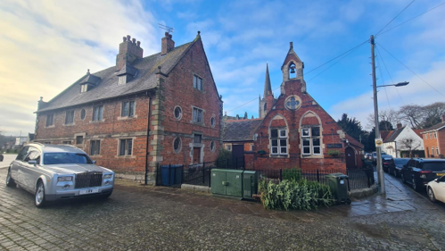
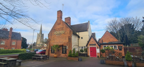
Public buildings are concentrated near the village centre, east of the churchyard. Notably, the Old Schoolhouse and Parish Rooms stand at the churchyard’s northeast corner, while the Rancliffe Arms Public House is situated opposite the entrance to Main Street on the east side of Loughborough Road.
Below is a map that describes the current plan, form and layout of the village/town.
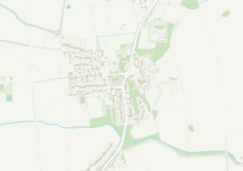
This map is reproduced from Ordnance Survey material with the permission of Ordnance Survey on behalf of the Controller of His Majesty’s Stationary Office © Crown Copyright. Unauthorised reproduction infringes Crown Copyright and may lead to prosecution or civil proceedings.
Rushcliffe Borough Council - 100019419
4.2 Landmarks, Focal Points and Views
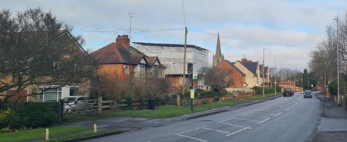
Approaching Bunny from the west along Wysall Road, two prominent landmarks—St Mary’s Church and Bunny Hall—dominate the village skyline.
St Mary’s Church, often referred to as the "Cathedral of the Wolds," is the largest village church in south Nottinghamshire, measuring over 140 feet (42 meters) in length. Its substantial west tower and tapering spire make it a conspicuous feature in the landscape, visible from various vantage points, including Wysall Road (see Figure 6).
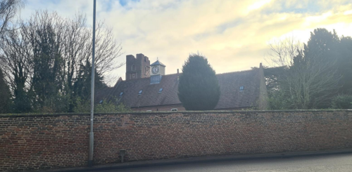
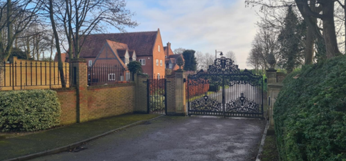
Bunny Hall, a Grade I listed country house originally built in the Elizabethan era and extensively rebuilt in 1720 by Sir Thomas Parkyns, features an 80-foot-high tower. Set within 14.5 acres of formal gardens and parkland, the hall's distinctive architecture and elevated position contribute to its prominence in views from the surrounding countryside.
Within the village of Bunny, St Mary’s Church serves as a prominent visual landmark. As one travels along Loughborough Road, glimpses of the church's distinctive spire emerge between buildings and trees, offering intermittent views that underscore its role in the village's character.
St Mary’s Church features a unique chancel, nearly as long as the nave, and displays both decorated and perpendicular architectural styles from the late medieval period. Key elements include a 13th-century east window, a lowered chancel roof from 1725, and a double shallow basin, also known as a piscina, which pre-dates the Black Death.
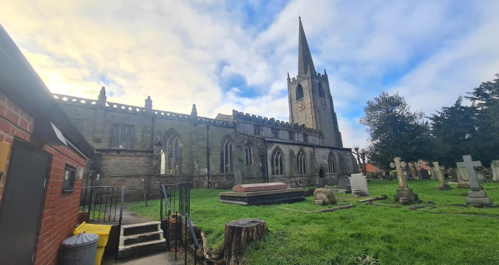
The nave, with its ten-bay arcade and distinctive pillars, also reflects perpendicular gothic character. Notable additions include stained glass windows in memory of prominent individuals and a font from the 11th century. The church has undergone repairs, with evidence of alterations like a low-pitched roof and clerestory windows added in the 15th century. The church also contains a sundial dated 1791 and a Royal coat of arms from 1803. From the churchyard there are glimpses through the treeline of Bunny Hall’s tower to the east.
The other landmark which is noticeable from outside of the village is Bunny Hall and its tower. The large country house, which was rebuilt around 1720 by Sir Thomas Parkyns. Subsequent additions and alterations in the late 18th and 19th centuries include a south front, an incomplete east front, and a west front designed by Parkyns himself. The building showcases red brick construction with blue brick detailing, ashlar dressings, and a slate roof. The tower at Bunny Hall can be seen.
From vantage points along Loughborough Road, other significant buildings can be observed, such as the Old Schoolhouse, the Parish Rooms, and the Rancliffe Arms Public House, all contributing to the village's historic streetscape. Additionally, Bunny Hall, with its distinctive tower, is visible over its boundary wall from certain perspectives, reinforcing its prominence in the village's landscape.
Elsewhere within the village, several vantage points offer picturesque views that contribute to its rural charm and historical character.
Main Street, lined with mature hedgerows and traditional buildings, provides a series of enclosed, intimate vistas that reflect the village's historic layout. In contrast, Moor Lane offers more open views, with its broader verges and fewer obstructions, allowing for expansive sight-lines that enhance the sense of space within the village.
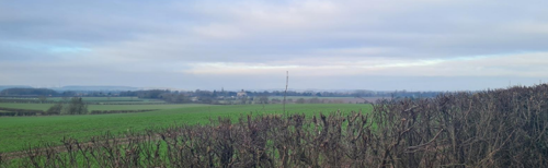
From the western fringes of the village, particularly at the ends of Main Street and Moor Lane, as well as from the southern end of Loughborough Road, there are notable views over the surrounding countryside. These perspectives extend towards Bunny Hill to the south, providing a visual connection between the village and its rural setting.
4.3 Open Spaces, Trees and Landscape
The village is distinguished by three principal open spaces that contribute to its historical character and
community value:
- Bunny Hall Grounds: Encompassing approximately 14.5 acres, featuring formal gardens, mature trees, and parkland that enhance the setting of this Grade I listed building.
- St Mary’s Churchyard: offers a quiet green space at the heart of the village.
- Village Green: Located in front of Bunny Church of England Primary School, serving as a communal area for recreation and gatherings.
A number of fields and paddocks are included within the conservation area boundary but views towards these are often restricted from the accessible areas due to the enclosed nature of the street scene. In spite of this the village retains a rural feel thanks to the hedgerows along Main Street and the grass verges and front gardens along Moor Lane and Loughborough Road. Wooded areas and individual mature trees further contribute to this rural character. Most of these occur along or to the east side of Loughborough Road in
association with Bunny Hall but there is also a significant group of mature trees at the junction of Church Street and Moor Lane.
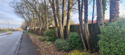
Tree-lined boundaries and grass verges along Loughborough Road, enhance the village's rural ambience in a space which could otherwise begin to feel very urban.
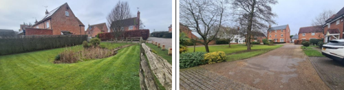
Areas like Moor View, a private residential cul-de-sac branching off Moor Lane, feature a mix of detached and semi-detached homes with mostly open gardens and driveways. Residents here have access to a private green space and a pond area, which has come to contribute to the area's character.
4.3.1 Open Spaces, Trees and Landscape SWOT Analysis
Strengths - what are the positives of the open spaces, trees, and landscape.
- Scenic Views: Some properties in Bunny have views over open fields, providing a sense of tranquillity.
- Well-used paths connect the village to the wider countryside.
- The village green and St Mary’s Churchyard serve as vital communal areas, offering "breathing space" at the heart of Bunny and fostering community interaction.
- Established trees contribute to biodiversity and the aesthetic quality of the village.
Weaknesses - what are the negatives of the open spaces, trees, and landscape.
- Some hedgerows are overgrown or have gaps, reducing their ecological connectivity and visual appeal.
- The village faces potential loss of tree canopy due to diseases like ash dieback and Dutch elm disease, which could impact the landscape's character.
Opportunities
- Planting new native hedgerows and replacing gaps can strengthen wildlife corridors and enhance the village's green infrastructure.
- Implementing a tree planting strategy can mitigate canopy loss and ensure the continuity of the village's wooded character.
- Encouraging residents to participate in local green initiatives can foster a sense of ownership and collective responsibility for the landscape.
Threats
- Potential development on the village's fringes, especially if intensive and insensitive, could encroach upon open spaces and alter the rural setting.
Works to Trees
You must contact the Local Planning Authority (LPA), Rushcliffe Borough Council before any works (cutting OR pruning) are carried out to trees within the Bunny Conservation Area.
Six weeks’ notice is required before any works to trees within the Conservation Area is carried out, even if they are not protected by a Tree Preservation Order (TPO).
If there is a tree which undergoes annual maintenance, include this information with the notice. It may be possible, upon agreement with the tree officer, that only one notice is required to cover the future annual maintenance.
Standard notification forms (a section 211 notice), further information and contact details.
A flow chart of the decision-making process regarding works to trees.
4.4 Public Realm
The majority of roads and pavements in Bunny are surfaced in asphalt. A notable exception to the standard paving is found outside the Old Schoolhouse and Parish Rooms, where flagstone surfacing provides a distinct and historically appropriate texture (see Figure 10).
In addition to this, the rural character is preserved in areas such as some private gravel drives, particularly around Bunny Hall, which harmonise with the village’s historic setting.
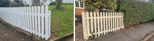
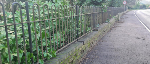
Boundary treatments throughout Bunny are varied but characterful, contributing significantly to the visual quality and heritage of the area. These include:
- Hedgerows and informal planting of shrubs and small trees
- Wooden fencing in domestic frontages
- Red brick boundary walls, particularly prominent around St Mary’s Churchyard
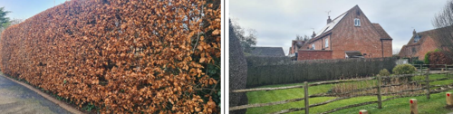
Most boundary walls are approximately 1 metre in height and finished with triangular brick copings. A few distinctive exceptions include:
- The Vicarage wall, rising to just over 2 metres
- The boundary wall at No. 2 Church Street, featuring lead-capped coping bricks
Boundaries are often enhanced with timber gates, battened doors, or other traditionally crafted entrance details, reinforcing the village’s rural and historical charm.
5 Buildings of the Conservation Area and Key Characteristics
5.1 Building Types and Activity
Bunny has a rich and varied historical and modern structures that reflect its rich heritage and evolving character.
The Historic Core
At the historic core is St Mary’s Church, dating from the 14th century it is the oldest in the village. Constructed entirely from stone in a Gothic architectural style. Notably, the church underwent restoration in 1718 under the patronage of Sir Thomas Parkyns, 2nd Baronet of Bunny Hall.
Bunny Hall: which was originally an Elizabethan red brick house with an 80-foot-high tower, Bunny Hall was rebuilt in 1720 by Sir Thomas Parkyns. The current structure features a castellated tower and a semicircular pediment, showcasing Parkyns' unique architectural style.
The Rancliffe Arms: This early 17th-century coaching inn, also designed by Sir Thomas Parkyns, features a tripartite fanlight and canted bay windows, reflecting its historical significance and architectural charm.
[Wikipedia]
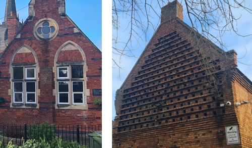
The Old Schoolhouse and Alms-houses: Built around 1700 by Sir Thomas Parkyns, this two-storey red brick building with stone dressings and a slate roof exemplifies a blend of English and Italianate design.
The 19th and 20th Century Additions
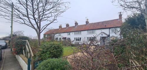
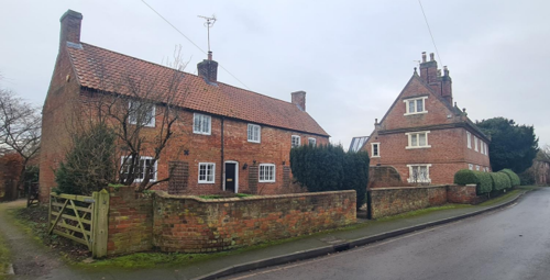
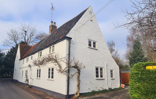
19th-Century Farmhouses and Cottages: These structures, including Ivy Cottage and 15 Church Street, are characterised by red brick construction, pantile roofs, and traditional casement windows, contributing to the village's rural charm. [Wikipedia]
20th-Century Dwellings: The village also features early to mid-20th-century houses and farm buildings, reflecting the architectural trends of their respective periods.
Modern Developments
Recent Residential Areas: New housing developments have emerged in the grounds of Bunny Hall, on the site of the former garage on Loughborough Road, off Moor Lane to the northeast, and on the site of Moor End Farm, introducing contemporary architectural styles to the village.
1970s Primary School: The flat-roofed primary school building from the 1970s stands in contrast to the village's traditional architecture, highlighting the evolution of educational facilities over time.
Modern Petrol Filling Station: Located to the south of the village on Loughborough Road, this facility represents the village's adaptation to modern infrastructure needs.
5.1.1 Building types and Activity SWOT Analysis
Strengths - what activities / places exist that makes the village / town great?
- The Rancliffe Arms Public House, St Mary’s Church, and the Village Hall serve as central hubs for community events, fostering social cohesion and local engagement.
- An extensive network of public footpaths and bridleways links Bunny to neighbouring villages and the surrounding countryside, promoting outdoor activities and sustainable transport.
Weaknesses - what activities / places exist that detract from making the village / town great?
- The A60 Loughborough Road experiences high traffic volumes, leading to noise and air pollution that detract from the village's tranquil character.
- Inadequate drainage systems have resulted in occasional localised flooding, affecting both infrastructure and property.
- Gated and private access areas can create physical and social separation from the broader village community.
- Key community venues, including the church, village hall, and playground, face insufficient parking facilities. During well-attended events there is congestion and accessibility challenges.
Opportunities - what activities/places could exist that would village/town even better?
- Enhanced wayfinding and footpath signalling (sympathetic to the character) to encourage walking and cycle tours.
- Developing heritage trails and informational materials can celebrate Bunny's historical assets, attract visitors and fostering local pride.
Threats - what activities / places would make village / town worse?
- Further traffic volume increase on A60 without mitigation, worsening noise and air quality.
- Closure or downsizing of key venues (pub, hall, church) through loss of funding or patronage.
- Infill development that displaces or fragments existing community green spaces.
- Cuts to parish or borough budgets that undermine maintenance of drains, play areas or footpaths.
5.2 Key Characteristics and Building Materials
Materials:
Traditional building materials were largely locally sourced. Bricks for example, were not transported far from where they were made, with most villages having their own brick pit and yard. This led to interesting village-specific sizes, colours and styles of brickwork. Roofs would have been made from local materials such as thatch until clay pantiles became popular. The traditional building materials within the Conservation Area are as follows:
Walls: Dominated by orange/red brick (sometimes painted white) with occasional ashlar details.
Roofs: Dominated by orange clay pantiles with various examples of slate and some plain clay tiles. Gable ends are mostly plain close verge where the tiles run to the edge of the brick gables but a number of buildings also have parapet gables.
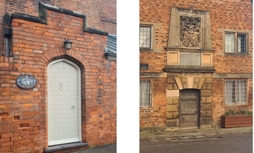
Windows: Side hung timber casement with lead glazing bars (in a variety of configurations), ashlar two light casements with single ashlar mullions and timber sliding sashes are most common types. The Old Schoolhouse also displays several oeil de boeuf windows. Arched brick and ashlar lintels are most prominent.
Doors: Timber in a variety of styles including part glazed, six panelled and battened and studded. Arched brick lintels.
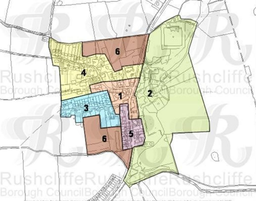
5.2.2 Key Characteristics: The village centre (Zone 1)
Key Characteristics / Architectural Features:
The village centre is anchored by St Mary’s Church and Churchyard, whose stone walls and tower provide a focal point. On the other side of the A60 stands the Rancliffe Arms coaching inn. Surrounding cottages, farmhouses, and Georgian houses sit behind low orange-brick walls and timber gates, with mature roadside trees.
5.2.3 Key Characteristics: Bunny Hall (Zone 2)
Key Characteristics / Architectural Features:
The area is defined by Bunny Hall and its estate: an 18th-century red-brick country house with tower, surrounded by historic outbuildings, formal terraces and gardens. Expansive parkland with specimen trees transitions into ancient woodland, creating a cohesive landscape that reinforces the village’s aristocratic heritage.
5.2.4 Key Characteristics: Main Street (Zone 3)
Key Characteristics / Architectural Features:
Main Street features a mix of detached and semi-detached homes—from traditional farmhouses to 20th century residences—interspersed with historic agricultural outbuildings. The north side is defined by mature hedgerows and stone walls, offering a green buffer. This variety of building types and planting creates a layered, rural streetscape.
5.2.5 Key Characteristics: Moor Lane (Zone 4)
Key Characteristics / Architectural Features:
Moor Lane comprises a mix of detached and semi-detached homes dating from the early 20th century to the present, alongside the flat-roofed 1950s primary school that lends a suburban character. Two modern housing developments bookend the lane, each set within newly planted landscaping that complements existing tree-lined verges.
5.2.6 Key Characteristics: Loughborough Road (south) (Zone 5)
Key Characteristics / Architectural Features:
Loughborough Road South is lined with early 20th-century detached and semi-detached homes set behind generous front gardens and grass verges. Opposite the Rancliffe Arms, a modern terrace housing block introduces contemporary form, while a petrol filling station marks the village’s edge. This mix creates what should be a delicate transition from historic core to modern necessities.
5.2.7 Key Characteristics: Moor Lane (Zone 6)
Key Characteristics / Architectural Features:
Paddocks and small fields at the fringe of the village, defined by a mix of hedgerows, post-and-rail fencing, and its open green space. These spaces offer open views into the surrounding countryside and into the village. Their semi-rural enclosure provides a vital green buffer between settlement and agricultural land.
5.2.8 Key Characteristics SWOT Analysis
Strengths – what is it about most existing buildings that looks good?
- Historic focal points (e.g. the church tower, village green) that give clear landmarks and “arrival” moments.
- Distinctive estate village architecture of Sir Thomas Parkyns, including consistent use of materials, proportions, and detailing.
- Large number of Listed Buildings contributing to a coherent historic character.
- Largely consistent low boundary treatments that unite varied building plots.
Weaknesses - what is it about most existing buildings that does not look good?
- Unsympathetic street lighting and road signage that interrupt historic views.
Opportunities - what could make existing buildings (or new builds) look good and contribute to the character of the area?
- Interpretation panels or heritage plaques to celebrate Parkyns’ estate architecture and reinforce local character.
- Use of traditional materials and design principles in new developments or extensions to reflect the local vernacular.
Threats - what could make existing buildings (or new builds) look worse and detract from the character of the area?
- Further erosion of the character of the village through the extension of properties, either through permitted development or approved plans.
- Introduction of incongruous or overly modern designs that ignore local scale, materials, and character.
- Pressure for infill development that compromises important views, settings of listed buildings, or green spaces.
5.3 Listed Buildings
Buildings on the Government’s List of Buildings of Special Architectural or Historic Interest are called “Listed” buildings and are protected by law. Consent is required from Rushcliffe Borough Council before any works of alteration, extension, or demolition can be carried out on any listed building.
Further information can be found in Rushcliffe Borough Council’s publication Listed Buildings in Rushcliffe.
The complete list of the Secretary of State’s Statutory List of Buildings of Special Architectural Interest or Historic Interest can be accessed online.
Names and details of the Listed Buildings and structures in Bunny Conservation Area (correct as of January 2024) are detailed in Appendix 1. All Listed Buildings are shown on the Townscape Appraisal plan, but some smaller structures such as gravestones may not be shown.
5.4 Key Unlisted Buildings
Contribution to the established character of the place can also come from buildings which are not recognised via listing or are not old. A plan with all of the positive contributions to the area can be found in Appendix 2 - Conservation Area Boundary and Townscape Appraisal Map.
6 Generic Management Plan for Conservation Areas in Rushcliffe
6.1 Introduction
In carrying out its planning functions, the Borough Council is required in law to give special attention to the desirability of preserving or enhancing the character or appearance of Conservation Areas. The Management Plan for a Conservation Area is a tool to ensure the special character of the area is preserved and enhanced. The management plans aim to:
- Outline a strategic management proposal for the preservation and enhancement of the Bunny Conservation Area.
- Act as a guide for professionals and residents alike regarding:
- features of value, worthy of preservation;
- characteristics worthy of preservation;
- opportunities for enhancement;
- development proposals which preserve and enhance the special character of the area.
- Inspire community commitment to conservation principles and reporting.
6.2 National and Local Policies and Guidance
There is a duty to formulate and publish management plans setting out policies and proposals for the preservation and enhancement of Conservation Areas. Many of these policies and proposals are common to all Conservation Areas, and these are set out in this document. The Central Government Guidance and Local policies applicable to Conservation Areas include:
- Rushcliffe Local Plan Part 1: Core Strategy, with a specific focus on:
- Design and Enhancing Local Identity [in part]
- Historic Environment
- Rushcliffe Local Plan Part 2: Development Policies, with a specific focus on:
- Conserving and Enhancing Heritage Assets
- Development Affecting Archaeological Sites
- The National Planning Policy Framework (NPPF), particularly, but not exclusively the chapter on Conserving and Enhancing the Historic Environment.
- The National Planning Practice Guidance (NPPG) (updated 2021 and subject to continual review)
- By Design: Urban Design in the Planning System – Towards Better Practice (2000)
- The Planning (Listed Buildings and Conservation Areas) Act 1990
- Historic England “Historic England Advice Note 1: Conservation Area Designation, Appraisal and Management”
The council will utilise the full range of strategic policy and guidance documents to ensure that development in Bunny Conservation Area is of a standard that enhances the amenity of the local area. The council will always look to use the most up-to-date versions of the document.
Supplementary documents may be issued for individual Conservation Areas where specific policies or proposals are needed.
6.3 Article 4 Directions
There are extra consents required in Conservation Areas. For example, in addition to the general control of development, you will
need to get permission for
- Any additions or alterations to the roof (for example, dormer windows)
- The installation of satellite dishes on chimneys, roofs or walls fronting a highway
- Any extension which extends beyond the side of the original dwelling house
- Any extension of more than one storey that extends beyond the rear wall of the original dwelling house
- Cladding the exterior of the dwelling
- Any demolishing of a building or part of a building that has a volume over 115 cubic metres
Article 4 of the Town and Country Planning (General Permitted Development) Order 1995, allows planning authorities to restrict
some permitted development rights within particular areas. This does not necessarily prevent development or change taking place
but enables the Local Authority to manage the design and detailing of the works, and potentially grant permission subject to appropriate conditions. The use of Article 4 Directions will be proposed where it is considered appropriate following the completion of each Area Appraisal across the Borough.
Details of Article 4 Directions for Bunny Conservation Area
There are currently no Article 4 Directions for Bunny Conservation Area.
6.4 Building Design
Mimicking the local vernacular is not the only way to ‘fit in’ with the character of a conservation area. National policy makes clear that contemporary designed, provided it is sympathetically designed, cannot be dismissed as an option. Therefore, good contemporary design will be encouraged where it respects the context’s character, scale and massing. This must be demonstrated in the Design and Access Statement submitted with any planning application.
Extensions to buildings in Conservation Areas should respect:
- The key characteristics of the original building, including scale, mass, materials and proportions
- The contextual setting and character of the Conservation Area
Copying like for like can devalue and destroy the ability to “read” historic change, and dilutes our historic heritage. Pastiche designs, incorporating poor imitations of other styles, will be resisted, particularly where they incorporate details which are not locally appropriate. Careful high-quality replication may be required in a few very sensitive locations.
In particularly sensitive locations, such as uniform terraces, exact replication may be necessary to maintain compositional unity. In that case, attention to details, choice of materials and high-quality workmanship are the keynotes. However, in some cases, a direct relationship is not impossible. For example, Flemish Bond brickwork cannot be replicated in cavity walls, and narrow lime mortar joints cannot be replicated in modern metric brickwork.
Where a new building is appropriate, on infill sites or where an existing building detracts from the character of the area, the opportunity should be taken to re-establish the streetscape, reinforce enclosure, open up distant vistas or views of landmarks or hide unsightly views.
“New and old buildings can coexist happily without disguising one as the other, if the design of the new is a response to urban design objectives” (DETR – “By Design”, p19).
As with extensions, good contemporary design which respects local character, and the context of the site will be encouraged.
All new buildings should respond appropriately to the existing frontage and normally follow the established building line. Development or redevelopment will normally be resisted if:
“it blocks important views identified in the individual appraisals, uses important open spaces identified in the appraisals, adversely affects the setting of any Listed or key buildings, fails to maintain or re-establish the streetscape where appropriate dominates its Conservation Area background fails to recognise the context of
the site destroys important features identified in the individual appraisals such as boundary walls, fences,
hedgerows or trees”
Where the quantity of contemporary schemes in a small area becomes significant and outnumbers older buildings within the area, further contemporary schemes could fundamentally shift the architectural character of the area and thus be harmful, even if well designed as an individual project.
New development that stands out from the background of buildings may be appropriate in exceptional circumstances if it contributes positively as a landmark to enhance the street scene, to highlight a corner or to signal a visual change of direction such as along a curving vista.
Any external lighting should be carefully designed and sited to minimise light pollution. Energy producing or saving devices are generally welcomed by the Council, but careful consideration is required when these are to be located in a Conservation Area and some may require planning permission. In particular, they should be positioned to minimise their impact on the building and on the local amenity.
6.5 Publicity and Knowledge Transfer
Ambiguity about additional controls within a Conservation Area raises the likelihood of inappropriate developments occurring which may damage the integrity of the conservation area designations.
Efforts have been made to engage local community groups in the development and review of the character appraisals. Empowering communities to define the special architectural and historic interest of the Conservation Area aims to raise awareness.
Whether the appraisal took a community-led or a council-led approach, upon reviewing all Conservation Areas, the public were invited to ask questions and comment during a public consultation. A consultation event also aimed to diminish any ambiguity about restrictions within a Conservation Area and increase the likelihood of sensitive and appropriate developments, maintaining the character of the area.
The council recognise the potential issues of turnover in residency and ownership of properties in the conservation area. Therefore, Rushcliffe Borough Council will periodically use their media outlets to highlight conservation area designations and the significant,
related planning controls.
If there are any queries about conservation areas, please email conservationareas@rushcliffe.gov.uk
6.6 Public Realm
General maintenance and upkeep to the public realm may include fixing damage to roads and pavements, and fixing issues with street lighting. Issues such as these can impact the quality of the Conservation Area.
The council aims to encourage works to the public realm that are in keeping with, or actively enhance the conservation area. Rushcliffe Borough Council can only advise on work within the public realm that does not require planning permission (for example work completed by statutory undertakers, such as the Highways Authority). In these instances, Rushcliffe borough council cannot prevent such work.
Nottinghamshire County Council are responsible for repairs to roads, pavements and street lighting. Report issues of repairs to roads, pavements and street lighting to Nottinghamshire County Council online.
Rushcliffe Borough Council will continue to undertake their duties in maintaining the public realm. Vandalism, fly tipping and street cleaning are all the responsibility of Rushcliffe Borough Council. Report issues to Rushcliffe Borough Council online.
You must contact the Local Planning Authority (LPA), Rushcliffe Borough Council, before any works (cutting OR pruning) are carried out to trees within the Bunny Conservation Area.
Six weeks’ notice is required before any works to trees within the Conservation Area is carried out, even if they are not protected by Tree Preservation Order (TPO).
Standard notification forms (a section 211 notice) - further information and contact details.
A flow chart of the decision-making process regarding works to trees.
6.7 Boundary Treatments
Where there is a proposal for a new boundary treatment to be installed, the council would encourage the use of boundary treatments within the area.
Within conservation areas, planning permission is required to alter, maintain, improve, take down or build any new gate, fence, wall or other enclosure with:
- A height of one metre or more if next to a highway (including a public footpath or bridleway), waterway or open space; or
- A height of two metres or more elsewhere.
Where planning permission is required to remove a wall, Rushcliffe Borough Council will aim to protect those boundary walls and fences that have been identified as positively contributing to the area.
Hedgerows are significant habitats for wildlife in lowland Britain. Regulations are intended to protect important hedges in the countryside. The policy applies to hedges that are more than 20m long, (or less if connected to another hedge) on or adjacent to:
- Land used for agriculture or forestry, including the keeping of horses or donkeys
- Registered common land and village greens
- Local Nature Reserves and Sites of Special Scientific Interest.
The policy does not apply if the hedge is within or on the boundary of the curtilage of a house.
6.8 Buildings at Risk
A few of the important buildings across the various Conservation Areas are currently vacant or not in regular use, which may lead to some being “at risk” of neglect or decay.
The Council will encourage and advise on renovation and repair work that is sensitive to the original or traditional historic character of the building and retains original features. The council will monitor the opportunity and potential for grant aid schemes to encourage the basic maintenance work necessary to ensure that key buildings within the conservation area are structurally sound and weather tight. However, given the current financial climate and outlook, such schemes are unlikely in the short to medium term.
There is a presumption against the demolition of buildings which contribute to the character of the area unless there are exceptional circumstances. It would benefit both the physical form and the function of the Conservation Area if these buildings were repaired, maintained and brought back into use.
Where the poor condition of a building or structure is as a result of neglect and lack of maintenance by its owner there is no requirement for the Borough Council to take its deteriorated condition into account when deciding whether demolition is appropriate. This is to avoid rewarding the deliberate neglect of buildings by representing such action as a way to obtain planning permission for demolition and redevelopment.
6.9 Enforcement
Rushcliffe Borough Council will, from time to time, assess and monitor changes in the appearance and condition of Bunny Conservation Area. This will ensure that where necessary enforcement action can be taken promptly to deal with problems as they arise.
Where co-operation cannot be gained by any other means, Rushcliffe Borough Council has the ability to use additional enforcement powers to tackle particular issues within conservation areas. The Council may take formal action if the condition of any building (listed or unlisted) which makes a positive contribution to the character of the Conservation Area is considered to be at risk.
The council will work in accordance with their enforcement policy, which aims to provide an efficient enforcement service in support of the Council’s statutory planning service. Rushcliffe Borough Council’s enforcement actions will remain transparent, consistent, and proportionate, as it is recognised that effective controls over unauthorised development assists in conserving the natural and built environment whilst helping to protect the quality of people’s lives and maintaining the Council’s integrity.
7 Appendix 1 – Listed Buildings (as of March 2025)
Grade: II
Listing entry number: 1248699
National grid reference: SK 58435 29630
Location: Stable Block at Bunny Hall, Bunny Hall Drive, Bunny, Bunny, Rushcliffe, Nottinghamshire
Grade: II
Listing entry number: 1277655
National grid reference: SK 58420 29694
Location: Barn Dated 1734 At Bunny Hall, Bunny Hall Drive, Bunny, Bunny, Rushcliffe, Nottinghamshire
Pair Of Gate Piers and Walls Extending Around Bunny Park
Grade: II
Listing entry number: 1277791
National grid reference: SK 59626 30129
Location: Pair Of Gate Piers and Walls Extending Around Bunny Park, Wysall Road, Bunny, Bunny, Rushcliffe, Nottinghamshire
Outbuilding To the North of Bunny Hall
Grade: II
Listing entry number: 1277786
National grid reference: SK 58410 29671
Location: Outbuilding To the North of Bunny Hall, Bunny Hall Drive, Bunny, Bunny, Rushcliffe,
Nottinghamshire
Grade: I
Listing entry number: 1249018
National grid reference: SK 58424 29594
Location: Bunny Hall, Bunny Hall Drive, Bunny, Bunny, Rushcliffe, Nottinghamshire
Sundial About 50 Metres South of Bunny Hall
Grade: II
Listing entry number: 1248700
National grid reference: SK 58465 29536
Location: Sundial About 50 Metres South of Bunny Hall, Bunny Hall Drive, Bunny, Bunny, Rushcliffe, Nottinghamshire
Range Of Barns and Carriage Archway at Bunny Hall
Grade: II
Listing entry number: 1249004
National grid reference: SK 58436 29682
Location: Range Of Barns and Carriage Archway at Bunny Hall, Bunny Hall Drive, Bunny, Bunny, Rushcliffe, Nottinghamshire
Small Tomb Chest About 50 Metres South of Bunny Hall
Grade: II
Listing entry number: 1249024
National grid reference: SK 58448 29525
Location: Small Tomb Chest About 50 Metres South of Bunny Hall, Bunny Hall Drive, Bunny, Bunny, Rushcliffe, Nottinghamshire
Garden walls and outbuildings of Walled Garden formerly at Bunny Hall
Grade: II
Listing entry number: 1248708
National grid reference: SK 58486 29894
Location: Garden walls and outbuildings of Walled Garden formerly at Bunny Hall, Loughborough Road
Grade: II
Listing entry number: 1248711
National grid reference: SK 58269 29546
Location: 5 and 7, Main Street, Bunny, Nottinghamshire
Stable Behind Number 15, Main Street
Grade: II
Listing entry number: 1248712
National grid reference: SK 58230 29506
Location: Stable Behind Number 15, Main Street, Bunny, Nottinghamshire
Old Water House in Field at Rough Hill
Grade: II
Listing entry number: 1248706
National grid reference: SK 56839 28782
Location: Old Water House in Field at Rough Hill, Gotham Lane, Bunny, Nottinghamshire
Cottage 12 Metres South of The Rancliffe Arms
Grade: II
Listing entry number: 1248710
National grid reference: SK 58356 29526
Location: Cottage 12 Metres South of The Rancliffe Arms, Loughborough Road, Bunny, Nottinghamshire
Grade: II
Listing entry number: 1277639
National grid reference: SK 58222 29685
Location: The Old Vicarage, Moor Lane, Bunny, Nottinghamshire
Ivy Cottage And Adjoining Walls
Grade: II*
Listing entry number: 1277626
National grid reference: SK 58208 29539
Location: Ivy Cottage And Adjoining Walls, 17, Main Street, Bunny, Bunny, Rushcliffe, Nottinghamshire
Grade: II
Listing entry number: 1277631
National grid reference: SK 58349 29558
Location: The Rancliffe Arms, Loughborough Road, Bunny, Bunny, Rushcliffe, Nottinghamshire
Grade: II
Listing entry number: 1277790
National grid reference: SK 58067 29561
Location: Rose Cottage, Main Street, Bunny, Nottinghamshire
Old School Incorporating Schoolhouse and Almshouses
Grade: II*
Listing entry number: 1249034
National grid reference: SK 58333 29613
Location: Old School Incorporating Schoolhouse and Almshouses, Loughborough Road, Bunny, Nottinghamshire
White House and Adjoining Barn
Grade: II
Listing entry number: 1277787
National grid reference: SK 58269 29635
Location: White House and Adjoining Barn, Church Street, Bunny, Nottinghamshire
Grade: II
Listing entry number: 1249036
National grid reference: SK 58227 29535
Location: 15, Main Street, Bunny, Nottinghamshire
Grade: II
Listing entry number: 1248714
National grid reference: SK 58208 29633
Location: The Grange, Moor Lane, Bunny, Nottinghamshire
Grade: II
Listing entry number: 1249031
National grid reference: SK 58321 29616
Location: Parish Rooms, Church Street, Bunny, Nottinghamshire
Church Of St Mary and Adjoining Wall
Grade: II
Listing entry number: 1248713
National grid reference: SK 58288 29598
Location: Church of St Mary and Adjoining Wall, Main Street, Bunny, Nottinghamshire
*The titles of these listings may not make it clear that all listed buildings always include all attached structures and extensions, regardless of age, and all detached outbuildings built before 1 June 1948 which are, or were at the time of listing, ancillary to the function of the primary listed building and were in the same ownership at the time of listing.
For example, when a house is listed, the listing will apply to extensions, porches, detached historic stables, barns, wash houses, privies etc. Such outbuildings and extensions are only exempt from the provisions of listing where the listing specifically excludes them. Appendix 2 - Conservation Area Boundary and Townscape Appraisal Map.
8 Appendix 2 – Conservation Area Boundary and Townscape Appraisal Map

Map showing the location of:
- Conservation Area boundary - red line
- Listed buildings - red
- Unlisted buildings - purple
- Positive open space - green
- Significant views - red arrows
- Significant tree - single green dot
- Group of trees - multiple green dotes
Conservation Areas
- Bingham Conservation Area
- East Bridgford Conservation Area
- East Leake Conservation Area
- Hawksworth Conservation Area
- Hickling Conservation Area
- Ruddington Conservation Area
- Thoroton Conservation Area
- Wiverton Conservation Area
- Langar Conservation Area
- West Leake Conservation Area
- Whatton in the Vale Conservation Area
- Costock Conservation Area
- Sutton Bonington Conservation Area
- Upper Saxondale Conservation Area
- Wysall Conservation Area
- Bradmore Conservation Area
- Car Colston Conservation Area
- Scarrington Conservation Area
- Orston Conservation Area
- Flintham Conservation Area
- Edwalton Conservation Area
- Aslockton Conservation Area
- Bunny Conservation Area
- Granby Conservation Area
- Keyworth Conservation Area
- Thrumpton Conservation Area
- Normanton on the Wolds Conservation Area
- Upper Broughton Conservation Area
- Kneeton Conservation Area
- Colston Bassett Conservation Area
- Cropwell Bishop Conservation Area