East Leake Neighbourhood Plan
East Leake Neighbourhood Plan 2013 - 2028
Final version November 2015
Contents
- 2.1 Number of New Homes and Relationship to Infrastructure
- 2.2 Phasing of New Housing
- 2.3 Types of New Homes Built for Sale
- 2.4 Issues of Building Standards and Design
- 2.5 Suitability of Sites for General Housing
- 2.6 Satisfying Local Housing Need for Affordable Housing
Section 3 - Business and Employment
- 3.1 Encouraging Retail Outlets and Services within the Village Centre
- 3.2 Support for Small and Start‐Up Businesses and those Working from Home
- 3.3 Support for Existing Large Employment Site
Section 4 - Transport, Communications and Traffic
- 4.1 Better and safer routes for pedestrians and cyclists
- 4.2 Support for Public Transport
- 4.3 Wider Transport Infrastructure Considerations
- 5.1 Containment of the Built Environment
- 5.2 Preservation of Wildlife and Rural Heritage
- 5.3 Green Spaces
Section 7 - Conservation History and Heritage
- 8.1 Priorities for Land Use in the Village Centre
- 8.2 Improvements to the area of the Gotham Road/Main Street T‐Junction
Section 9 - References and Abbreviations
Section 1 - Introduction
1.1 East Leake is a historic rural village of about 7000 people in south Nottinghamshire, well connected to Loughborough, Nottingham, Derby and Leicester. It is largely self‐contained and acts as a hub for surrounding smaller villages.
1.2 The government’s “National Planning Policy Framework” (March 2012) introduced measures to allow local people to produce their own distinctive Neighbourhood Plans, reflecting the needs and priorities of their communities. These plans must conform to the Framework, which is about sustainable development, i.e. positive growth.
1.3 The local planning authority is Rushcliffe Borough Council, whose Local Plan Part 1, Core Strategy [note: for the adopted local Plan Part 1, Core Strategy, see section 9.1 below which contains a link to the adopted plan and all the supporting documentation and explains how these are referenced in this plan] was being developed during the same timescale as the East Leake Neighbourhood Plan (2011‐2014) and was formally adopted by Rushcliffe Borough Council in December 2014. The Neighbourhood Plan must conform to the Core Strategy which allocates a minimum of 400 new homes to East
Leake for the period of the plan (2013 to 2028). This requirement cannot be altered by the Neighbourhood Plan. This Neighbourhood Plan covers the same planning period as the Core Strategy, 2013 to 2028. The purpose of the Neighbourhood Plan is to shape the sustainable development of East Leake over the plan period.
1.4 The Neighbourhood Plan was prepared by a Project Team set up by East Leake Parish Council. The membership and terms of reference of the project team are on the Neighbourhood Plan website, with minutes of meetings and other relevant documents. The scope of the plan aligns exactly with East Leake Parish boundary, and this “Neighbourhood Area” was formally agreed by Rushcliffe
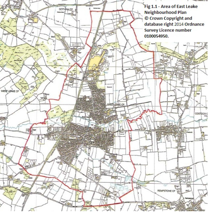
Borough Council in December 2012. The Parish boundary is shown in Fig. 1.1
1.5 The Neighbourhood Plan Project Team worked very closely with the East Leake Community Plan Group which was simultaneously producing the community‐led plan, published in April 2014. The Community Plan explains the relationship between the two plans. The Community Plan Group undertook extensive consultation to cover the remits of both plans, including drop‐in days and a survey undertaken by questionnaire. The report of the survey is on the Community Plan website.
1.6 In March 2013 the Neighbourhood Plan Project Team printed a “Draft Vision” for East Leake’s future development, based on views expressed by residents, as a colour leaflet delivered to every household with invitation to comment. Various other consultation activities on the draft vision took place and the consultation for both plans is fully described in the Statement of Consultation that accompanies this plan (see the Neighbourhood Plan Web page2).
1.7 The statutory pre submission public consultation on the Neighbourhood Plan, as required in Section 14 of the Neighbourhood Planning (General) Regulations 2012, ran from 15 Sept to 31 October 2014. Leaflets and response slips were circulated to residents. Statutory consultees, landowners, businesses, and other stakeholders were invited to comment via email or letter. This process is
fully documented in sections 6.4, 6.5, 6.6 and Appendix 8 of the Statement of Consultation.
Following this consultation, the Plan has been subject to formal processes leading to a referendum for its adoption. If adopted, the policies will be used alongside those of Rushcliffe Borough Council to decide whether future planning applications are approved. The plan will be reviewed every 4 to 5 years by the Parish Council to allow for changing conditions. These reviews will include consideration of changes to the following: Policy H3 ‐ housing mix; Policy H6 (a) walking distance, and a future policy on affordable housing (section 2.6).
Fig. 1.1 East Leake Neighbourhood Plan Area
1.8 Below are chapters on Housing, Business/Employment, Transport, Infrastructure, Environment, Leisure, History, and the Village Centre. Each chapter starts with a quote from the draft vision, states objectives arising from the vision, formulates policies to achieve these objectives, and gives justification.
1.9 In addition to this Neighbourhood Plan document, the documentation forming the Neighbourhood Plan submission includes the Statement of Consultation, and its appendices; and the Statement of Basic Conditions. All these documents are published on the East Leake Neighbourhood Plan Web Page and the Rushcliffe Borough Council Neighbourhood Planning page.
1.10 The plan refers to many other documents as evidence. These form the “evidence base”. Some documents are referred to frequently in the plan by abbreviated references, and there is a key for these abbreviations in section 9.1. Elsewhere footnotes are used to provide links to references. The Neighbourhood Plan webpage lists other documents used in the preparation of this plan. Higher resolution copies of some of the maps are also available on the web site.
Section 2 - Housing
Vision: “We believe that the capacity of essential services such as health, education and drainage should be increased in step with any new developments within East Leake and surrounding smaller villages.”
“We are concerned that recent new housing developments have been mainly targeted at well‐off families (i.e. mainly detached 4 and 5 bedroom houses); our aim is to maintain the diversity of the village population by ensuring that new housing is provided for young people, lower income families and older people. We will restrict new housing to sites within walking distance of the village centre, and will ensure that its character is sympathetic to the local tradition in terms of materials and scale. We will encourage smaller scale housing developments on infill sites in preference to
large‐scale estates on green field sites. We will encourage and support improvements in the quality and energy efficiency of older housing.”
2.1 Number of New Homes and Relationship to Infrastructure
Objectives
2.1.1 Provide a positive contribution to meeting housing needs.
2.1.2 Ensure infrastructure is adequate to support proposed housing growth.
Key Points
2.1.3 This plan provides a positive contribution to meeting housing needs (as it is required to do), but consultation has revealed that many residents have concerns about rapid growth. They value the rural setting of East Leake and feel that it should remain a village‐style community and not a town. A substantial proportion object to further expansion once the proposed minimum 400 additional
new homes have been delivered. People are concerned about disappearance of green fields. Their greatest concern, however, is that development of the village infrastructure is not meeting housing growth [note: see justification, paras 2.1.14 to 2.1.28, for sources].
2.1.4 Rushcliffe Borough Council’s Core Strategy allocates East Leake additional housing based on its assessment as a sustainable location for growth due to its services and facilities. See Greater Nottingham Sustainable Locations for Growth and Accessible Settlements Study for Greater Nottingham, both of which can be viewed on the Supporting Studies webpage. However since this
study was undertaken, the primary schools have filled, there are increased concerns over the capacity of the sewage pumping station and the Health Centre, and the bus service to the Queens Medical Centre has been discontinued. Developments already going through planning approval, if permitted, will increase the number of homes by upwards of 25%, and spread the built area of the village outwards, meaning that a greater proportion of local journeys will be by car rather than walking or cycling. The assertion that East Leake is a sustainable location for housing therefore needs to be revisited.
2.1.5 The Rushcliffe Borough Council Core Strategy includes an Infrastructure Delivery Plan 2012. Pages 166 to 168 summarise the assessment for East Leake. This is based on 400 additional homes (only) in East Leake, and includes several items where it states that further investigation is required. The infrastructure requirements for development over and above 400 homes have not been considered
and are therefore not understood at this time. The latest infrastructure update undertaken by Rushcliffe Borough Council for examination of their Core Strategy, dated Feb 2014, also tested for 400 additional homes and has not assessed needs of currently approved planning applications which is way in excess of this [note: For current numbers see separate document – Planning Applications for Housing Development on East Leake Neighbourhood Plan]. Rushcliffe Borough Council intends to update the infrastructure delivery plan in Part 2 of the Local Plan.
2.1.6 Residents in East Leake believe that there are three urgent and critical infrastructure requirements at present:
- insufficient primary school places.
- a Health Centre building that is under capacity and past end of life.
- an overloaded sewerage system – particularly the capacity of the pipe from the pumping station to the sewage works, with problems exacerbated by the lack of segregation of storm‐ water and foul‐water drains at the pumping station.
- linked to the concerns about the sewage are more general concerns about flooding.
2.1.7 It appears that these elements of infrastructure have now gone beyond the stage where improvements can be achieved by a series of modest incremental changes. Step changes are needed as follows:
- addition of a third primary school, or a replacement school for Brookside primary school, as there is insufficient space on its site for sufficient expansion.
- a new Health Centre to replace the existing building (or redevelopment of the existing building).
- increased capacity for drainage/sewerage, including capacity at the pumping station Sites are needed for the new primary school, and probably the Health Centre, and could be progressed as developer contributions for future larger housing sites.
2.1.8 Policy H1 therefore adopts the minimum number of new homes in the Core Strategy, but stipulates that after adoption of the Neighbourhood Plan phasing of any developments above this figure will be managed to ensure that the major improvements to infrastructure, where found necessary by the respective infrastructure providers, have been completed, or monies secured for their
provision.
2.1.9 Other elements of the infrastructure are also known to be in need of improvement, and a further review of infrastructure will be undertaken by Rushcliffe Borough Council under Part 2 of the Local Plan to establish how further development (i.e. over and above 400 additional homes) can be properly supported. Rushcliffe Borough Council commit to updating the Infrastructure assessment
periodically.
2.1.10 As of November 2014 the secondary school in East Leake has capacity to cope with the additional housing planned for East Leake. Should there be future concerns, these will be considered as the Neighbourhood Plan is reviewed every 4 to 5 years.
2.1.11 It is expected that a number of smaller infill sites lying completely within the current village built‐up area may come forward for redevelopment and should not be subject to the above.
2.1.12 It is acknowledged that by the time this plan is Made, the proposed minimum figure in the Core Strategy will already have been exceeded by approvals to date.
2.1.13 Section 3.1 deals with retail businesses etc. in the village centre. It is recognised that a substantial benefit of new housing is to increase the viability of a range of businesses that residents desire. There is possibly a debate to be had in the future about whether East Leake should be designated as a town rather than a village – this plan is neutral on this issue, and uses the term “village”
throughout to reflect the current status.
Policy H1 – Number of new homes
- The minimum number of new homes to be built in East Leake in the period 2013 to 2028 will be 400 as laid down in Rushcliffe Borough Council’s Core Strategy.
- Further new residential development above this 400 minimum number will only be supported where it is demonstrated that the provision of improved infrastructure, including health centre provision/ improvements, primary school place provision and sewerage capacities, can be achieved in time to serve the needs of the development. Conditions, planning obligations and S106/ Community Infrastructure Levy contributions, of an appropriate and reasonably related scale, will be sought and used to manage the phasing and occupation of new dwellings.
A further review of infrastructure under part 2 of the Local Plan shall be undertaken by Rushcliffe Borough Council in conjunction with the above and other infrastructure providers, to cover any proposed numbers of homes over and above those sites that have planning permission. A prioritised list of infrastructure requirements will be submitted by East Leake Parish Council as part of this review.
Justification – Number of new homes, infrastructure in general
2.1.14 In Section 9 (Planning and Housing) of the East Leake Community Plan Survey 2012 [ELCP]:
- Fig. 9.2, 88% disagreed that East Leake should expand by more than 400 homes, 85% disagreed that green field sites were the best option, 74% thought that building of new homes should be phased, 87% thought that housing should be located within easy reach by foot to the village centre and public transport.
- “When asked where financial incentives that come as part of the new housing development should be allocated the most popular choice was building a new Health Centre (73% ranked this as a high priority), Fig. 9.3.”
- “In their comments on planning and housing, respondents tended to express concerns about and opposition to the proposed development of 400 new homes in the village, concerns focused on the existing infrastructure in the village and how it might cope with the increased population, and there were also worries about East Leake losing its village identity and becoming a town as a result of the new development (Figure 9.6).”
2.1.15 In Rushcliffe Borough Council leaflet “Fresh Approach” East Leake Parish Profile: “Comments from local people also highlight pressure on services within the village. Feedback from consultation with residents informs us that the Health Centre is struggling to cope with existing patient numbers, and local schools are struggling to accommodate pupil numbers.”
2.1.16 In East Leake Parish Council 2009 Parish Plan consultation [SoC, Appendix3]: “The freestyle comments showed a range of views on the size and nature of future housing developments, with the following emerging as recurring themes:
- the need for infrastructure (sewerage, roads, roundabouts, schools, health services etc.) to be developed before or alongside new housing developments …”
Justification – Health Centre Capacity
2.1.17 In Section 8 (Health and Social Care) of the East Leake Community Plan Survey 2012 [ELCP]:
- “When asked what additional health and social care services they would like to see in East Leake, a large proportion of respondents (41% of those who made a comment in response to this question) took the opportunity to complain that the existing Health Centre is, in their view, too small and in need of modernization (Figure 8.3). There were also requests for specialist clinics and services such as physiotherapy, diabetes clinics, minor surgery, etc.”
- “Comments on healthcare facilities and access to social care in East Leake largely reflected the issues raised in response to the earlier open question on additional health care services (shown in Figure 8.3). Once again the predominant concern was that the current Health Centre is seen to be unable to cope with the increasing population and is perceived to be in need of modernization (half of those who made a comment mentioned this).”
2.1.18 In 2002 outline planning permission was granted for a two storey building to replace the East Leake Health Centre and library [Planning application 02/01378/OUT]. A report from the Greater Nottingham Lift project, included in the planning application for the Keyworth Health centre [Planning application 02/01403/OUT] at about the same time, states on page 40 that the East Leake Health Centre building is "CLASP construction [4 CLASP (Consortium of Local Authorities Special Programme) were prefabricated buildings for use in the public sector developed in the 1950s by English local authorities], not suitable for provision of health services in the 21st Century". Twelve years later the building is still in use. (The report was written to obtain funding for replacing several local Health Centres – in the event funding was used for Health Centres in other villages in Rushcliffe.)
2.1.19 A small GP practice used to operate a separate surgery on Main Street. This has recently closed, adding additional patients to the Health Centre.
2.1.20 At a meeting in December 2014 with the Clinical Lead for Rushcliffe Clinical Commissioning Group, it emerged that the additional patients projected from the houses already approved by Rushcliffe Borough Council as at 1 December 2014 (say 2,500 patients) would probably fill the capacity created by recent short‐term additions to the health centre building. It was noted that there is no opportunity to expand the facility further, because of space constraints. There could also be no ability to bring hospital clinics to the Health Centre, as encouraged by current Government policy. This was subsequently confirmed in a letter to the Neighbourhood Plan Project on 22 December. [SoC, section 5.11]
Justification ‐ Schools
2.1.21 In Section 5 (Education) of the East Leake Community Plan Survey 2012 [ELCP]:
“In their comments on education provision, the most frequently raised issues were concerns about existing over‐crowding and how this might worsen once the new houses are built (Fig. 5.2)”
2.1.22 Section 5.10 of the East Leake Neighbourhood Plan Statement of Consultation [SoC] contains notes of a meeting on 24 April 2014 with East Leake schools and the Local Authority, which documents the pressure on primary school places.
2.1.23 Data supplied by the Local Education Authority in July 2013 illustrates the tension between capacity and projected demand for primary school places. See the statement agreed with the Education Authority “East Leake Primary Schools, Analysis of Capacity to cope with Housing Growth” in the evidence base on the Neighbourhood Plan website.
Justification – Sewerage Capacity and Flooding
2.1.24 Section 5.5 of the East Leake Neighbourhood Plan Statement of Consultation [SoC] contains notes of a meeting on 13 December 2013 with representatives of Severn Trent Water, describing issues with the pumping station capacity.
2.1.25 Data obtained by the Parish Council from Severn Trent in April 2014 about East Leake Sewage treatment Works shows the volume that passes through an estimated orifice at inlet as follows:
- Current as built: 9065 hd and 1951 m3 /day
- Known Short Term (2014‐2019) 10,575hd and 2249 m3 /day
- Projected long term (2020‐2039) 11,057hd and 2287 m3 /day.
(hd is heads per day – a measure of population served.)
2.1.26 The planning applications for 150 houses on Costock Road and for the development at Stanford Hall both demonstrate some uncertainty about the capacity of the sewerage infrastructure and the ability of Severn Trent to upgrade it in the short term, and include planning conditions about sewerage [Planning applications 13/0228/OUT (committee minutes condition 17) and 12/02070/HYBRID (condition 10)].
2.1.27 Flooding is an issue of great concern to residents, particularly when combined with discharge of sewage into the Kingston Brook, which floods over the children’s playing fields. Photographic evidence of floods is provided in the Evidence base on the East Leake Neighbourhood Plan webpage.
2.1.28 In response to a Freedom of Information request, the Environment Agency supplied the following details in October 2014 [SoC, 5.5]:
“East Leake Sewage Treatment Works has a permitted dry weather flow (DWF) of 1729 cubic metres per day and a Population Equivalent of 9137. Actual measured flows indicate that the average Q80 flow (equivalent to the DWF) for the last four years is 1544 cubic metres per day, i.e. the works has roughly 200m3/day headroom, around 1300 people (at 150L/head).”
At December 2014, planning permissions for 663 additional homes have been approved [note: for current numbers see separate document – Planning Applications for Housing Development on East Leake Neighbourhood Plan Web page], plus additional load from the Stanford Hall development. This demonstrates that the Sewage Treatment Works will need to be upgraded.
2.2 Phasing of New Housing
Objectives
2.2.1 Encourage evenly spread development of East Leake over the period of the Core Strategy (2013‐ 28).
2.2.2 Provide for any change in circumstance either within the market (demand) or in relation to the requirements of the Plan or District area (need) and allow development rates to react accordingly.
Key Points
2.2.3 For an existing community to grow in a socially and economically sustainable way, a continuous supply of new homes should be available and new residents should be integrated into the village over a period of time, with services, facilities, transport, and employment opportunities developing to match the growth. This policy therefore aspires to even out growth in new homes across the
plan period, giving the community time to adapt and grow its facilities and welcome and integrate the new residents.
2.2.4 The Core Strategy trajectory for delivering 400 homes in East Leake is 50 homes each year from 2018/19 to 2025/26. [RBC Core Strategy, Appendix D] The Neighbourhood Plan supports this trajectory, however it is likely with planning applications already approved that delivery will exceed this 17, and will be brought forward into the period 2014‐18.
2.2.5 Policy H2 therefore strengthens and promotes the Planning Authority’s role in monitoring and co‐ordinating the timing of delivery of homes across larger developments of 50 or more homes in East Leake over the plan period. The aim will be to work with developers to even out overall housing growth over the whole period, for the benefit of infrastructure delivery, the integration of new residents, and to promote a stable market, whilst providing the ability to react to market forces, including known projected growth in employment opportunities.
Policy H2 ‐ Phasing of new homes over the period 2013 to 2028
As part of the planning application process for the sites for 50 or more homes, a housing trajectory and phasing plan for the delivery of new homes and infrastructure should be submitted. The trajectory should take into account, where possible, the infrastructure requirements of the development, and the cumulative provision of infrastructure provision from other development.
Justification
2.2.6 The Stanford Hall Defence Rehabilitation centre is due to be occupied in 2018. East Leake is the nearest settlement, and residents are welcoming this development. It is important in order to reduce journey times that delivery of new housing is timed to coincide with demand arising from this development for homes for employees. The National Rehabilitation Centre will open later in the plan period, and again the housing trajectory needs to take this into account.
2.2.7 By way of precedent for an evenly paced rate of growth, Cuckfield neighbourhood plan includes a trajectory for phasing housing at a sustainable pace.
2.3 Types of New Homes Built for Sale
Objectives
2.3.1 Ensure that new homes built for sale are of the size and type for which there is demonstrable need.
2.3.2 Maintain a mixture of property types to ensure social diversity.
2.3.3 Encourage a strong housing ladder, with no gaps, to enable families to remain in the village as they move up the housing ladder.
2.3.4 Provide an adequate supply of new homes for older people wishing to downsize (freeing up family homes).
Key Points
2.3.5 Recent new developments of market housing in East Leake have generally provided for the higher end of the market – i.e. 4 and 5 bedroom detached houses. This is leading to an imbalance in the housing provision in the village, working against population diversity, exacerbating the difficulties facing first time buyers, and meaning that the housing market “ladder” is developing some serious gaps. Policy H3 seeks to address the imbalance for the future.
2.3.6 Rushcliffe Borough Council provides studies and modelling of household types20 informing the optimal mix of houses to be built for the Borough, and a report was commissioned by the East Leake Neighbourhood Plan Group to assess the housing mix needed for East Leake21. All developments of market housing in East Leake will be expected to meet current assessment of housing need. At December 2014 this is as follows:
- 1 and 2 bedrooms - between 30% and 40%
- 3 bedrooms - between 40% and 60%
- 4 bedrooms - between 10% and 20%
- 5+ bedrooms - between 0% to 5%
2.3.7 In addition when submitting applications in East Leake, developers will be asked to provide a diversity of home types (and therefore ultimately prices) within these categories, along with a rationale for the proposed breakdown, e.g. 4 bedroom semi‐detached as well as detached homes; terraced, semi detached and detached 3‐bedroom homes; a mixture of 1 and 2 bedroom bungalows, houses, and flats.
2.3.8 This policy deals with the standard type of housing developments currently seen – those undertaken by national or regional chains of house builders. However these are limited in scope, and the plan also aspires to provide diversity beyond that which such developments typically provide. “Alternative” types of housing developments would be welcomed, and should thus be viewed favourably if they appear as planning applications. Examples of this would include:
- Live/work units (see also policy B2)
- Sheltered accommodation schemes for older people, particularly where these are very close to the village centre (see also policy V1)
- Self build opportunities, for both individuals and groups, including delivery of serviced plots for self build on larger housing developments
- “Green” homes, i.e. with design targeted at carbon reduction and other environmental considerations, rather than driven by costs.
2.3.9 Furthermore, it is recognised that population and household factors are not the sole determinants
in a housing mix policy – other important factors include:
- flexible homes which allow for the changing needs of households to be met without the need for frequent sales/moves
- market conditions/viability considerations
- provision for home working and home based caring for dependent relatives
- design and layout considerations (e.g. lower buildings/bungalows may help to retain views, terraces and block can help to produce a village rather than a suburban feel to developments, apartment blocks can be an effective way of providing care based market accommodation for older people and represent a higher density effective use of land.
The targets for housing mix are therefore expressed as a range for each bedroom size.
2.3.10 In the interests of social sustainability, proposals for mixed residential/employment developments, or residential developments that in some other way create opportunities for permanent employment within East Leake, will be welcomed, (subject to other policies and planning considerations). See also section 3.2.
2.3.11 It is intended that the housing mix in particular is an item that will be considered every 4 to 5 years when the Neighbourhood Plan is reviewed, to ensure that the mix continues to be in line with needs and demands.
Policy H3 – Types of Market Homes
On developments of 10 or more homes developers will provide a mixture of homes for the market that broadly reflects Rushcliffe Borough Council’s and East Leake’s most up to date assessments of housing needs derived from projections of household types, as shown below:
- 1 and 2 bedrooms - between 30% and 40%. If purpose built for older people, e.g. homes with care and support or “retirement villages”, up to 100%
- 3 bedrooms - between 40% and 60%
- 4 bedrooms - between 10% and 20%
- 5+ bedrooms - between 0% to 5%
In addition, a diverse mix of home types within each of the categories will be provided in line with projected need, to include for example: serviced homes for older people, bungalows, apartments, a mixture of detached, semi detached and terraced homes of all sizes.
Justification
2.3.12 Interviews with East Leake Estate Agents took place in February 2013, and these are reported in the Neighbourhood Plan Statement of Consultation, section 5.2. Both Estate agents described various gaps in the housing market in East Leake.
2.3.13 From the East Leake Community Plan Survey 2012 [ELCP Fig. 9.1] responses to the question on perceptions of housing need:
“Homes and apartments suitable for smaller families and single people attracted the highest proportion of ‘high need’ responses (41%), followed by bungalows (32%) and smaller 3‐4 bedroomed houses including semi‐detached (31% – Figure 9.1). The least popular option was large executive houses with 4 or more bedrooms, which was rated in the lowest need category by two‐thirds of respondents.”
2.3.14 In NPPF, para 159: “Local planning authorities should … identify the scale and mix of housing and the range of tenures that the local population is likely to need over the plan period which:
- meets household and population projections, taking account of migration and demographic change;
- addresses the need for all types of housing, including affordable housing and the needs of different groups in the community (such as, but not limited to, families with children, older people, people with disabilities, service families and people wishing to build their own homes); and
- caters for housing demand and the scale of housing supply necessary to meet this demand;”
2.3.15 From the Rushcliffe Borough Council Housing Market Assessment Update, 2012:
“The low figures for typical ‘starter homes’ (flats and terraces) are clear in the above table (sale frequency by property type). It is probable considering the make‐up of housing in the district that the data shows a fair reflection of the general proportions of each property type. However this also underlines a likely imbalance in the demographic make‐up of the district, which could be exacerbated if a more balanced housing mix, with more accessible units for younger and less wealthy households is not developed.”
2.3.16 Analysis of the Office of National Statistics Neighbourhood Statistics from the 2011 census reveals that East Leake has a higher than average proportion of people in the 65+ age bracket than the wider area. There is a significantly lower proportion of single person households than the wider area, a higher proportion of 2 person households and a slightly higher proportion of 3 person
households. This strongly indicates that two and three bedroom homes are in the most demand.
2.3.17 An analysis and report produced by Housing Vision [note: The Implications of Household Projections for the Mix of Market Housing in East Leake: 2013 – 2028, December 2014, Housing Vision, included in the evidence base on the East Leake Neighbourhood Plan web page] in December 2014 considers population and household projections in East Leake and concludes that 71% of the projected requirement is for one and two bedroom properties, and 29% for 3 bedroom and larger houses. This report was commissioned alongside the consultation to help address comments. It is noted that population mix in East Leake is similar to that of Rushcliffe, and to that extent the report can inform the housing mix for all the 400+ houses.
2.4 Issues of Building Standards and Design
Objectives
2.4.1 Provide additional sound insulation requirement due to proximity of East Midlands Airport
2.4.2 Ensure developments are well designed, in particular that they contribute to the character of East Leake, and to the wider aims of sustainability, in that they promote a sense of community by providing connectivity and social spaces.
2.4.3 Ensure that in mixed developments of market and affordable homes, the affordable homes are indistinguishable in terms of external quality finishes etc.
Key points
2.4.4 East Leake is close to the approach to Runway 27 at East Midlands Airport and there can be a high level of aircraft activity in the area. For approximately 70% of the year, arriving aircraft approach the airport from the east, and East Midlands Airport operates on a 24 hour basis with a substantial level of night activity. Policy H4 provides that new residential developments should ensure that appropriate sound insulation measures are included. This does not address the concerns of existing householders, but will start to improve the situation for future residents.
2.4.5 The airport is safeguarded from developments in the local area that may affect safe aircraft and airport operations. These developments include tall structures, developments that can attract birds, and wind turbines. The airport is a statutory consultee under the provisions in Circular 1/200324 [note: Safeguarding aerodromes, technical sites and military explosives storage areas, Department for Transport] and their views should be sought and comments fully taken into account in considering applications for planning permission. This requirement is enforced by Rushcliffe Borough Council and no additional policies are necessary in the Neighbourhood Plan to ensure this.
2.4.6 Properties adjoining the railway are also adversely affected by noise, and use of the line could increase over the lifetime of any new homes. However the measures in policy H4 to alleviate the impact of aircraft noise cover the entire parish of East Leake and thus it is unnecessary to include an additional policy statement about railway noise.
Policy H4 – Aircraft Noise
Where required following a noise assessment, planning conditions will be imposed to ensure that new dwellings include appropriate measures (for example enhanced sound insulation and mechanical ventilation systems) to mitigate the effects of aircraft noise.
2.4.7 Building for Life 12 [note: Building for Life 12 - Design Council] is the industry standard for the design of new housing developments. It contains questions on: Integrating into the Neighbourhood; Creating a Place; and Street and Home. Assessment is on the basis of a traffic light scheme. If rigorously applied to new developments, they are better places to live – they connect into the existing community and have a character that is locally inspired. The standards promote the East Leake vision of a community with a distinctive local tradition, where people socialise and are able to walk or cycle for many of their everyday needs, rather than always use the car.
2.4.8 “Good design” is about integrating new developments into the village, and also about bringing the best of contemporary design into East Leake. This Neighbourhood Plan does not attempt to dictate a particular architectural design for new developments. It does, however, wish to ensure that developers pay due regard to current relevant national design guidance, codes, standards, toolkits,
award schemes etc, meeting standards and wherever viable, exceeding them. In addition to Building for Life (see 2.4.7 above) other current examples include: Housing Design Awards, Secured by Design, Lifetime Homes, any successor to the Code for Sustainable Homes, relevant BREEAM schemes. It is important that due consideration is given to “green/eco” issues in design, e.g. incorporating high standards of heat insulation and solar panels and giving full consideration to energy efficiency and renewable energy provision . Excessive on‐street parking is an issue that can cause issues for residents, by blocking pavements etc, so all developments must meet or exceed guidelines for off road parking.
Policy H5 – Design and Building Standards
- New developments will adhere to all the principles of the Building for Life Standard [BfL] (or any successor schemes), to help deliver East Leake’s vision to remain an attractive, functional, and sustainable place to live, as it grows. On the traffic light scoring system, the design of new developments will normally be expected to score as many ‘greens’ as possible, minimise the number of ‘ambers’ and avoid ‘reds’.
- Developers submitting applications will demonstrate how they have considered Building for Life and other national design guidance and standards [note: Some current examples of national design guidance and standards are listed in 2.4.8, but there may be others relevant in particular cases, and the policy allows for these to change over time].
- In mixed market and affordable developments, the affordable elements will be distributed throughout the development and externally indistinguishable.
Justification – Aircraft noise
2.4.9 In the free text question in the Community Plan Questionnaire [ELCP, 10.2] asking for the things residents did not like about living in East Leake, aircraft noise topped the list with 17% of all comments.
2.4.10 [NPPF, para 123] states that planning policies should aim to mitigate and reduce to a minimum adverse impacts on health and quality of life arising from noise from new development, including through the use of conditions. This is supported by the second aim of the Noise Policy Statement for England (Department for Environment, Food & Rural Affairs, March 2010) to mitigate and minimise adverse impacts on health and quality of life from environmental, neighbour and neighbourhood noise within the context of Government policy on sustainable development. In this context, “environmental noise” includes noise from transportation sources. It recognises that
noise exposure can cause annoyance and sleep disturbance both of which impact on quality of life and can give rise to adverse health effects and requires that all reasonable steps should be taken to mitigate and minimise adverse effects on health and quality of life.
2.4.11 At a meeting between the Neighbourhood Plan Project Team and the Principal Planner of East Midlands airport in April 2014, it was suggested that the Neighbourhood Plan should include a policy to include noise mitigation measures in new housing. [SoC, 5.9]
2.4.12 Details of the airport’s measures to manage the impact of aircraft noise can be found in the East
Midlands Airport Noise Action Plan and Sustainable Development Plan7, including 2012 noise contours.
2.4.13 Using the methodology of Planning Policy Guidance 24 [note: Planning Policy Guidance 24. This is now replaced by the NPPF, which contains no methodology for assessing noise exposure or recommendations for mitigation. However the legislative framework, standards, and guidance that underpinned PPG24 remain relevant], the night‐time noise contour for the majority of East Leake shows as NEC B (Noise Exposure Category) ‐ “Noise should be taken into a account when determining planning applications and, where appropriate, conditions imposed to ensure an adequate level of protection against noise”.
2.4.14 In Aug‐Sept 2011 noise monitoring was undertaken at Stanford on Soar by East Midlands Airport. This location lies further outside the noise contour than East Leake, yet the report concludes that “the monitoring location is assessed to fit into NEC A during the day and NEC B at night”.
2.4.15 A planning application for 154 houses on Gotham Road [note: Rushcliffe Borough Council planning application reference 07/00524/OUT] went to appeal and conditions 9 and 10 specified noise assessment and ventilation required to protect the homes against aircraft and railway noise. See the appeal report and East Leake Parish Council’s response to the 2012 initial publication Rushcliffe Core Strategy consultation for further details.
Justification – Design and building standards
2.4.16 “Good design is a key aspect of sustainable development, is indivisible from good planning, and should contribute positively to making places better for people.” [NPPF, para 56]
2.4.17 The Neighbourhood Plan group undertook two training courses on Building for Life in April 2012 plus a further workshop on May 2014, inviting other local groups to attend. The group assessed East Leake developments rigorously against the scheme as they came through for planning permission, but found the developers’ own assessments often to be superficial and a “box ticking exercise”. This part of the policy therefore strengthens the importance of the standard in assessing new schemes. The aims of the standard align closely with the East Leake Neighbourhood Plan vision, in particular the intention to maintain a “walking distance village” with its own distinctive and attractive look.
2.5 Suitability of Sites for General Housing
Objective
2.5.1 Ensure that the location of new housing development takes account of a range of constraints.
Key Points
2.5.2 In order to preserve the sense of community and village feel, East Leake should be developed to maximise the number of journeys that can be undertaken walking, cycling and by public transport. Therefore any sites allocated for general housing should be as near to the village centre as possible. For the duration of the plan period there are sufficient potential sites within a walking distance of
1.25km from the T‐junction to allow for the expansion envisaged. All permitted developments will therefore be within this distance. “Walking distance” covers a walking journey via any combination of the existing highway, a right of way, or a new road or footpath. Walking speeds vary greatly between individuals, but 1.25km equates to an average walking time of 17‐18 minutes {Note: This was calculated by using Google Maps for walking journeys to the edges of the 1.25km zone along main routes]. Cycle routes should be as short as possible, but could be longer than the walking route. Walking routes that allow for mobility scooters, baby buggies etc. will be expected. Routes that involve steps or other obstacles would need strong justification for inclusion. Improvements by developers to the existing village footpath and cycle path network to bring sites within the required walking distance will be welcomed. (Note: provision of footpaths and cycle paths is covered in the transport policies, section 4.)
2.5.3 Note that there is no implication here that all sites within the 1.25 km walking distance are suitable for housing. Other constraints apply and are documented in this Neighbourhood Plan, the Rushcliffe Local Plan, and other policies, guidance and legislation. This Neighbourhood Plan covers only East Leake Parish; other parishes are within the walking distance limit but this plan has no jurisdiction over them.
2.5.4 It is intended that the 1.25 km walking distance in particular is an item that will be considered every 4 to 5 years when the Neighbourhood Plan is reviewed, to ensure that housing needs can continue to be met.
2.5.5 Compactness and rural feel are important to residents, and we wish to avoid a sprawling settlement that merges with nearby villages. East Leake has always been a distinct community from neighbouring villages, and wishes to maintain this character. Therefore policy H6 stipulates that any green field sites allocated should be contiguous with the current built area of the village. Also, any site allocated within East Leake Parish should be adequately separated by open countryside from any neighbouring settlement.
2.5.6 There is a gypsum mine in the vicinity, and housing should not be built directly above, or close to, mined areas. There is a need to preserve the ability to extract existing mineral deposits in the future, so development should not take place either in the areas where mineral deposits are present and/or allocated for future mining operations. British Gypsum provides further information as requested by developers. Section 3.3, policy B3 supports development of the British Gypsum site, and due regard should be given to safeguarding its potential future growth when considering any new housing applications in the vicinity.
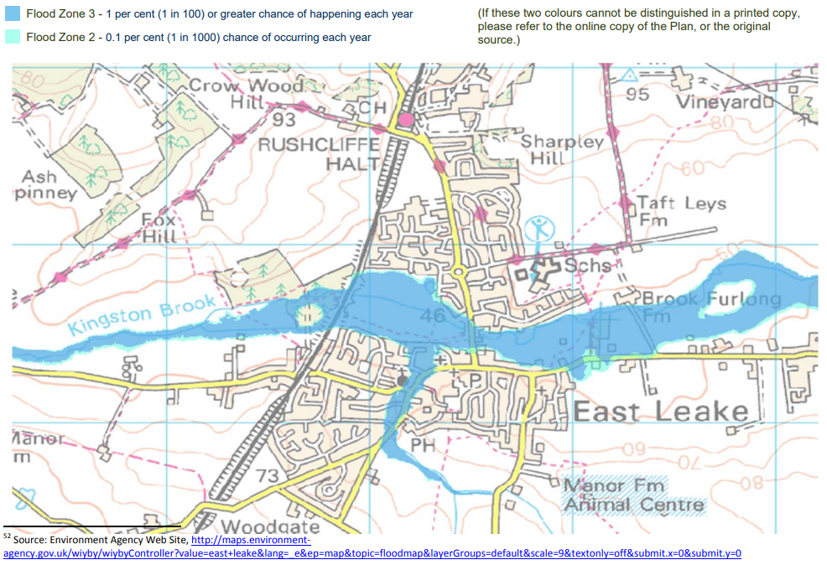
2.5.7 There is a need to mitigate the potential of flood risk to existing properties that new development might bring.
2.5.8 There is a desire to protect rural views and a green ridgeline around East Leake. This is dealt with in section 5, policy E1.
2.5.9 If there is a choice of sites, brown field sites should be developed in preference to green field sites and the quality of agricultural land should be taken into consideration.
Policy H6 – Sites where housing development will be permitted Applications within East Leake Parish will be considered for housing development outside the existing village built boundary at the time of application only if ALL the following conditions are met:
- Most homes built on the site shall be within 1.25km walking distance of East Leake Village Centre, defined here as the T‐junction between Gotham Road and Main Street AND
- The site adjoins the existing built envelope of East Leake village along at least one of its boundaries AND
- There is genuine open countryside separating the proposed site from the built up areas of neighbouring villages AND
- New homes are not sited above or close to existing Gypsum workings, or known mineral deposits for which there is a plan in place to extract the deposit in the future. (see Fig. 2.5/1 below) AND
- New homes are not sited on a floodplain within Environment Agency Zones 2 and 3; i.e. which has a moderate or significant flood risk where there are no flood defences or within the extent of extreme flood (see Fig. 2.5/2). (Developers would be required
to demonstrate any additional flood modelling work that has taken place in order to supersede the flood zone maps.)
Justification
2.5.10 Rushcliffe Borough Council Strategic Housing Land Availability Assessment includes sites around East Leake that would more than cater for the proposed target number of houses. There is no need, therefore, to consider those sites that are less suitable in terms of a number of criteria that matter to residents.
2.5.11 Minimising car journeys is an essential part of sustainability. The NPPF endorses this view in several places, including paragraph 38: “Where practical, particularly within large‐scale developments, key facilities such as primary schools and local shops should be located within walking distance of most properties.”
2.5.12 Policy 8 of the Rushcliffe Borough Council Core Strategy, [RBC CS] includes the following as one of its criteria for assessing suitability of housing sites:
“The existing or proposed accessibility of a location by walking, cycling and public transport.”
In section 3.12.2 (when assessing suitability of community facilities) it states:
“If community facilities are to serve the entire community they need to be accessible, hence the need for them to be located near to public transport and also be accessible by walking and cycling. Encouraging access by more sustainable means can also have health benefits.”
2.5.13 The walking distance of 1.25 km is justified as follows:
- “Greater Nottingham Sustainable locations for Growth” uses a 1km catchment area when considering settlements for sustainability and states this is roughly a 15 minute walk.
- This is increased to allow for walking routes rather than “as the crow flies” distances.
- The existing furthest built up edges of East Leake (the top of Woodgate, the British Gypsum site bus stop, the lane to the scout hut on West Leake Road) are approximately 1.25km from the T‐junction.
- The Strategic Housing Land Allocation Assessment 2013 [RBC EX29] includes more than enough sites within this distance to cater for the proposed target growth during the plan period.
- Precedents in Neighbourhood Plans for using walking distance as a criterion for allocating housing sites are:
- Thame (South Oxfordshire) which draws a 20 minute walking distance as a criterion for site selection
- Broughton Astley where an appeal judged walking distance from the centre to a site as material
2.5.14 In its policy 3, when discussing the green belt, the Rushcliffe Borough Council Core Strategy [RBC CS] talks about “the need to maintain the openness and prevent coalescence between settlements” and policy H6 of the East Leake Neighbourhood Plan takes this principle down to a more local level by maintaining villages as distinct settlements.
2.5.15 The following Neighbourhood Plans include policies to maintain separation of settlements:
Barnham and Eastergate; Broughton Astley; Ascot, Sunninghill & Sunningdale ; Tattenhall; Cuckfield. Several others draw up “settlement boundaries” with part of the rationale being to prevent coalescence of settlements.
2.5.16 Consultation and research into the Gypsum constraint is documented in section 5.4 of the East Leake Neighbourhood Plan Statement of Consultation [SoC, 5.4]. The NP project talked to geologist experts at British Gypsum and the relevant minerals policy experts at Nottinghamshire County Council. British Gypsum stated, “with respect to mining under properties, we do not mine
underneath people’s houses ‐ we are required to leave a half depth property protection pillar – for example if the mine is 100m deep, we will leave a 50m standoff to the property. The difficulty home owners have with underground mine workings is that when they do a search and they were to identify that there were mine workings beneath their property they could struggle to get a mortgage due to the risk of mining related subsidence.”
Fig. 2.5/1 Gypsum workings/deposits
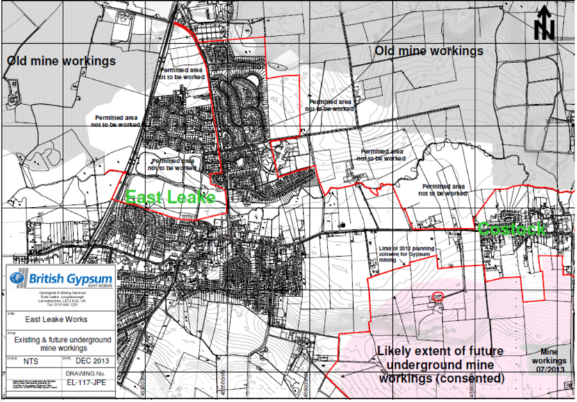
Fig. 2.5/2 East Leake Flood Risk Map
2.6 Satisfying Local Housing Need for Affordable Housing
Objectives
2.6.1 Ensure that the affordable housing supply in East Leake continues to be developed at an appropriate rate.
2.6.2 Ensure that the mixture of types of new affordable homes meets need.
2.6.3 Improve opportunities for people with a local connection to obtain affordable housing in the future.
Key Points
2.6.4 Note that the term “affordable housing” [NPPF, Annex 2] has a specific meaning – “Social rented, affordable rented and intermediate housing, provided to eligible households whose needs are not met by the market.” It does not mean lower cost housing built to be sold to the public (which is addressed in section 2.3 above). It includes “shared ownership” homes where people buy a
proportion of the property and pay rent on the remainder, thus providing a way to move from renting into home ownership.
2.6.5 Social sustainability is about building communities. People who work in East Leake and have family connections with it need to have options that allow them to live in the village. There is not a large pool of private sector rented accommodation in East Leake and there is a perception that young people who would like to stay in the village are unable to do so because of affordability and the
difficulty of obtaining a rental property. Older people currently living in large houses in the village, as well as those living away and wishing to be nearer family in East Leake, need access to high quality affordable options. People employed in the village need the option of living here, to reduce commute time, and carbon emissions, and to help maintain their life/work balance.
2.6.6 Housing developments in East Leake will aim to meet the Rushcliffe Borough Council target for building affordable housing. Before adoption of the Core Strategy [RBC CS] this was covered by policy HOU7 of the Non Statutory Replacement Local Plan which sought up to 30% affordable housing on sites of 15 dwellings or more or over 0.5 hectares, subject to negotiation. The figure changed in policy 8 of Local Plan Part 1, Rushcliffe Core Strategy, adopted by Rushcliffe Borough Council in December 2014, to 20% of houses built on developments of more than 5 dwellings or 0.2 hectares. In line with the Borough Council’s Strategic Housing market assessment lifecycle model (2012), provision of affordable housing will be broken down as follows: 42% intermediate housing/shared ownership; 39% affordable rent; 19% social rent. Within this breakdown, Rushcliffe Borough Council specifies percentages for the various house types. No additional policy for East Leake is needed to ensure this happens, merely enforcement by Rushcliffe Borough Council
of their existing policy.
2.6.7 Integration of the affordable housing within new developments is essential. It should be distributed throughout the developments and use the same design and building materials as the market housing so that they are indistinguishable. They should not be hidden from view.
2.6.8 The consultation version of this Plan contained at this point a draft policy H4 which would have given priority to people with a local connection when social housing is allocated. 85% of resident respondents to the consultation supported this draft policy. It was not possible at that time to deviate from Rushcliffe’s housing allocations policy, which gives priority to people across the whole of Rushcliffe, based on need so the draft was removed from the Plan. If the village wishes it can be pursued when the Plan is reviewed every 4‐5 years, or in the future when Rushcliffe Borough Council consults again on its allocations policy.
Section 3 - Business and Employment
Vision: “We aim to enhance local employment opportunities, in particular improving facilities for start‐up businesses. We will encourage retention and widening of the range of facilities that serve the needs of the community. ”
3.1 Encouraging Retail Outlets and Services within the Village Centre, Policy B1
Objectives
3.1.1 Encourage a cluster of retail and service outlets in the village centre, offering both range and choice.
3.1.2 Support proposals for new retail and service outlets outside the village centre area where there is a clear rationale for them to be at that particular location rather than in the village centre.
3.1.3 Support the use of East Leake as a service hub for neighbouring villages.
Key Points
3.1.4 Section 8 includes further vision and policies relevant to development of the village centre area, including recognition of the importance of allocating land for parking in the centre of the village. See the Fig. 8.1/1 for the area designated as the “village centre” in this plan.
3.1.5 East Leake has historically offered a wide range of shops and services. The village acts as a hub for neighbouring villages, increasing the viability of businesses, services and public transport.
3.1.6 Clustering retail and service outlets in the village centre is about overall sustainability. It allows access by public transport, and maximizes walking/cycling journeys as opposed to journeys by car. It facilitates the provision of parking for those needing to travel by car, and allows a single trip to fulfil a number of purposes.
3.1.7 Losses in the past few decades, regretted by residents, include three banks, clothing shops, gents barber and the petrol station. Several new shops (including a delicatessen, bakery, and greengrocer) have been established in the past few years and are welcomed by residents. Small independent traders offering a range of services are generally welcomed. There is some call for another supermarket. Having a mixed area in the centre, including cafes and restaurants as well as shops and services, appears to work well. The village is considered to already be well provided with takeaway food outlets [note: August 2014 – Fish and chip shop, two Chinese takeaways, pizza, Indian restaurant/takeaway, mixed restaurant/takeaway] and hairdressers. There are calls for a family friendly pub with good food.
3.1.8 There are some existing retail outlets outside the designated village centre area, and this Neighbourhood Plan does not seek to limit these. Typically they provide a valuable service to their immediate local residential area.
3.1.9 Policy B1 does seek to curb locating new retail outlets outside the village centre because doing so could weaken the viability of the village centre and overall sustainability of the village. Therefore B1 requires applicants to provide a clear rationale for the location; however it is not prescriptive about the criteria that will be used to form a judgement, as this will vary widely between applications. Some reasons for approval might be outlets that clearly serve their immediately local housing area, or that would not sit well with the village centre for one reason or another.
Policy B1: Support for retail and other services and businesses requiring public frontage
- In the area designated as the village centre, development of new and improved, or extended, retail outlets and other services and businesses requiring public frontage will be permitted, in each case falling within Use Classes A1‐A4, particularly where they extend the range of types of products and services offered. This will be subject to there being no significant adverse impact on amenity, particularly residential amenity, by reason of the scale and form of development proposed, the levels of activity generated by the proposal, the level of traffic generated, excessive noise or light pollution, smell, dust etc. Conditions may be used, where appropriate, to mitigate against adverse impacts.
- Outside the area designated as the village centre, new proposals for retail and other services and businesses requiring public frontage will be supported where the planning application includes a clear rationale for them to be at that location rather than in the village centre.
Justification
3.1.10 In the 2013/14 East Leake Business Survey [SoC section 5.8] there were 17 representations on the subject of village centre parking (the greatest number of responses on any topic), and 4 businesses mentioned pedestrian crossings.
3.1.11 In the East Leake Community Plan survey [ELCP]: Fig. 4.1 ‐ 96% shop within the village, 38% disagreed that ‘the village has a good variety of shops and businesses’ and 30% disagreed that ‘the local shops are well stocked with my daily / weekly requirements’. Fig. 4.3 shows requests for greengrocer [note: A new Greengrocer has opened since the report was published], bank, and another supermarket
3.1.12 The Rushcliffe Core Strategy [RBC CS]: on the importance of commercial retail centres; [Paragraph 3.6.2.] on the importance of centres for social cohesion and the diversity of retail facilities.
3.1.13 [NPPF, Para 23] on the role of local planning authorities in planning shopping centres
3.1.14 Over the past few years there have been several changes of business in the shops in the village centre, with no long periods of shops standing empty. There is some evidence of businesses which have been seeking premises in the area for some time, and two such statements from businesses are included in the Statement of Consultation, along with an audit of retail premises to form a baseline for future comparison, showing 26 properties on Gotham Road and 14 on Main Street, none of which were vacant at the time of the audit. [SoC 5.8].
3.2 Support for Small and Start‐Up Businesses and those Working from Home
Objectives
3.2.1 Encourage suitable live/work facilities as part of new residential developments.
3.2.2 Encourage all new large scale development applications (including residential) to create permanent employment opportunities.
3.2.3 Encourage provision of facilities for start‐up, follow‐on and small businesses. Assist small firms to grow. For instance: shared/managed office space; small units for light industry; rentable meeting rooms; storage facilities; shared reception and clerical services, acting as a local hub for information and support services for business. Charities and other local organisations could also make use of such facilities.
Key Points
3.2.4 East Leake has a number of small business sites scattered in locations across the parish. These are mainly located within residential areas, and on the whole their scale and nature is such that they do coexist happily. They are valued for the local employment opportunities they bring and their contributions to the local economy.
3.2.5 The parish area contains a number of farms and it can be important to their viability that they are able to diversify their operations, and this plan supports this, where it does not adversely impact on other residents, the environment, or the rural character of the area. Rural rights of way should be protected in any such development, so that the public can continue to enjoy access to the
countryside.
3.2.6 There are known to be a large number of residents who work from home in East Leake, in a wide range of businesses and services. Some of these are at the stage where they need to grow into employing staff and renting business premises rather than operating from home. To minimize journeys to work, increase employment within the village, and maintain existing local business to
business links it would be helpful if these needs could be accommodated within East Leake, and developers are encouraged to provide suitable schemes as part of housing developments.
3.2.7 Live/work developments in other areas of the country are encouraged by the Government and have proved successful – i.e. developments that combine residential and small scale business use ‐ and this plan encourages including these in new developments in East Leake.
Policy B2: Support for Small and Start‐Up Businesses and those Working from Home
- Planning applications to provide office accommodation, small light business units, and shared/managed business facilities are encouraged, in each case falling within Use Class B1 , throughout the built area of the village, having due regard to other policies and subject to there being no significant adverse impact on amenity, particularly residential amenity, by reason of the scale
and form of development proposed, the levels of activity generated by the proposal, the level of traffic generated, excessive noise or light pollution, smell, dust etc. Conditions may be used, where appropriate, to mitigate against adverse impacts. - Planning applications in rural areas outside the built up area of East Leake (e.g. farms) with a proposed change of use to diversify the business will be supported in principle, where they do not have a significant adverse impact on amenity (included residential amenity as detailed in (c) above), rights of way, the environment, or the rural character of the area, and they conform to all relevant traffic and design standards. Conditions may be used, where appropriate, to mitigate against adverse impacts.
Justification
3.2.8 In the 2013/14 East Leake Business Survey [SoC, section 5.8] 13 businesses identified a need for business support of one kind or another, and 8 requested small business/office units.
3.2.9 East Leake Community Plan survey [ELCP]: Sixty‐one respondents reported that they own, run or are thinking of starting their own business within East Leake, and of these just two said that they had a need for light industrial office and/or storage units within the village to help to develop the business.”
3.2.10 Rushcliffe Core Strategy [RBC, CS]: [Policy 5 point 6] on diversifying and supporting the rural economy; [3. 5.1] on providing employment; [3.5.15] on service and their retail centres as important employment locations.
3.2.11 NPPF: para 21 on live/work units; para 28 on diversification of agricultural businesses.
3.3 Support for Existing Large Employment Site
Objectives
3.3.1 Support the only large employment site in the village, i.e. the British Gypsum site on Gotham Road, in order to provide employment opportunities for local people and help the overall viability of East Leake as a sustainable settlement.
3.3.2 Support any further economic development to provide additional employment on this site, or otherwise contribute to the efficiency and overall health of the business.
3.3.3 Promote this area of the village as the preferred area for any development of industry falling outside Use Class B1, where this can be achieved without detriment to nearby residents or the environment.
Key Points
3.3.4 The employers on the British Gypsum site provide a range of employment opportunities. Employees contribute to the vibrancy of the village by using local shops and services, and public transport.
3.3.5 The gypsum operation has historical importance in the development of East Leake. Gypsum mining and processing is increasingly a high technology operation, and over recent times this has reduced any less favourable effects on local residents. However the site is close to housing and any future expansion should be considered with rigorous reference to relevant standards (noise, dust etc.).
3.3.6 In addition to the Gypsum operation, a medium sized employer on the site (Weatherford) provides high technology services to the oil industry.
3.3.7 Journeys to work are an important consideration in sustainability. Having both residential and employment areas within the parish potentially increases the number of cycling and walking journeys, reducing vehicle based commuting journeys and hence carbon emissions. The site has reasonable road links, with routes for heavy vehicles that take it away from East Leake village centre and residential areas. The site has a rail link, currently used for industrial purposes and also by the Great Central Railway Nottingham (a heritage railway), but not linked into the national passenger timetable. The site is on the bus routes to Loughborough and Nottingham with conveniently located bus stops.
3.3.8 Industrial uses (other than Use Class B1) in other areas of the village would sit less comfortably with residential areas and green spaces.
3.3.9 The CEMEX sand and gravel quarry between East Leake and Rempstone is at present operating outside Use Class B1, but the expectation is that operations here are temporary and that the land will be restored to agricultural use and/or green space once the extraction is complete, according to its planning permission conditions. Restoration includes wetland and conservation, with all rights
of way to be retained through the life of the site. The Nottinghamshire County Council Minerals Local Plan Preferred Approach consultation document published in October 2013 included potential site specific allocations, and identified two extensions to East Leake quarry. If the allocations were permitted this would extend the life of the site to approximately 2033. The proposed restoration schemes would tie into the existing permitted scheme.
Policy B3: Support for Business Development of the British Gypsum Site and elsewhere in the Parish of East Leake
- Proposals for economic development within the East Leake British Gypsum site, including expansion, will be welcomed in principle: where they increase overall employment, or otherwise contribute to the efficiency and overall health of the business, or bring new businesses onto the site; if the amenity of nearby residents is protected as detailed in (b) below; and subject to other planning approval processes.
- Proposals for industrial use falling within Use Classes B2 and/or B8 or otherwise, and/or generating significant volumes of movements of heavy vehicles elsewhere in the Parish of East Leake will be supported only where:
- there is good public transport provision;
- a transport management plan is agreed to ensure compliance with the existing area wide weight limit which restricts the movement of heavy goods vehicles through the village centre [note: In particular the Gotham Road/Main Street junction] and residential streets;
- there will be no, or minimal, negative impact on visual amenity and green space, (a positive impact would be preferable);
- there will be no significant adverse impact on residential amenity, by reason of the scale and form of development proposed, the levels of activity generated by the proposal, the level of traffic generated, excessive noise or light pollution,
smell, dust etc.
Conditions may be used, where appropriate, to mitigate against adverse impacts.
Justification
3.3.10 Rushcliffe Core Strategy [RBC CS]: point 5 of policy 5, encouragement for British Gypsum site.
3.3.11 NPPF: para 21, planning positively for creative or high technology industries.
Section 4 - Transport, Communications and Traffic
Vision: We will seek to improve connections between the different parts of the village, and out into the countryside beyond, for both pedestrians and cyclists; in particular we want all new developments to enhance the network of routes within the village. We will press for improvements to public and community transport links with facilities and transport interchanges outside the village.
4.1 Better and safer routes for pedestrians and cyclists
Objectives
4.1.1 Better connections between different parts of the village to encourage walking and cycling within the village.
4.1.2 New routes to, and within, new developments to ensure that these are properly integrated into the village and are not isolated from adjoining areas.
4.1.3 Improved connections to the existing network of walking routes into the surrounding countryside to maximize the value of the village’s rural setting.
4.1.4 Safe walking and cycling routes to schools to reduce the use of cars on the ‘school run’.
4.1.5 Well located bus stops with a shelter, raised kerb, clearway enforcement where required, good lighting, and real time information at suitable stops, to promote the use of public transport.
Key Points
4.1.6 New pedestrian and cycling routes within developments should be safe and include design features such as lighting and an open aspect, which deter anti‐social behaviour. Signage should be provided where appropriate.
4.1.7 New routes should also be convenient and provide as direct a route as possible to key locations in the village and to the strategic network of footpath and cycle links around the village as shown in Fig. 4.1/1. As far as their legal status is concerned, where within the built up area they should be tarmacked and lit and adopted as highway; where providing linkage to rural paths they should be
recorded on the Definitive map held by the Countryside Access team.
4.1.8 A definitive list of the existing network of public footpaths and rights of way into the countryside is shown at Fig. 4.1/2. This is complemented by other important connecting paths within the built up area of the village which also form part of the strategic network and are listed at Fig. 4.1/3
4.1.9 Priority improvements to the strategic network currently include improvement (in keeping with its rural character) of the green footpath/cycle path along Sheep Plank Lane which is shown in Fig. 4.1/1, and pedestrian facilities on the railway bridges at Woodgate and Gotham Road because of the nature of the roadway (double bend). Upgrades to signage, lighting, stiles, gates etc may be sought.
4.1.10 Connections between new developments and existing neighbouring developments are important for pedestrian convenience to minimize walking distances and to create a more walkable neighbourhood.
4.1.11 Note that where such links have not historically been provided, such as between Brickley Crescent and the Meeting House Close development, unofficial ‘cut through’ routes have arisen along pedestrian desire lines (a path created as a consequence of foot traffic).
4.1.12 New developments should not, therefore, prejudice links to future development sites by closing off potential access routes or prejudice their viability by holding them as “ransom strips” [note: Ransom strip ‐ a small but crucial piece of land which is needed to access a property, commonly a development site]. Future linkages should be allowed for in developments, and the adopted public highway should go right up to, and include the boundary to safeguard future access. If this is impractical (e.g. due to maintenance considerations) such strips should be transferred into public ownership, i.e. East Leake Parish Council or Rushcliffe Borough Council.
4.1.13 New developments should follow the principles set out in Building for Life 12, Section 1 Connections [BfL] and Manual for Streets, Section 4 Layout and Connectivity [MfS].
Policy T1: New developments and connectivity
Where necessary to achieve the objective of improving connectivity within the village and where appropriate to the location of the development, all new development should provide safe, convenient internal footpaths and cycle paths to allow easy access for both pedestrians and cyclists to:
- The centre of the village and Health Centre
- Brookside and Lantern Lane Primary Schools and East Leake Academy
- British Gypsum site
- Costock Road playing fields
- The nearest bus stop on the No. 1 Loughborough to Nottingham route
- The strategic network of footpaths and rights of way around the village and into the surrounding countryside shown in Fig. 4.1/1
- Neighbouring developments
Provision should be made for the ongoing maintenance of any foot or cycle paths provided under this policy through adoption of the path as highway or by recording the path as a public right of way on the Definitive Map or by other appropriate mechanism.
Policy T2: Strategic network of footpaths and cycle paths
Developments in the plan area will be required to contribute, wherever possible, (through Section 106 Agreements, section 278 Agreements, Community Infrastructure Levy, and/or direct investment or works) to improvements to the strategic network of footpath and cycle links shown in Fig. 4.1/1. Where such improvements impact on the historic centre of the village, materials, surfacing and
light touch signage appropriate to the Conservation Area status should be used.
Any areas of development land required to safeguard a future link identified in the strategic network, or to safeguard a link to a potential development site, should be included in the adopted public highway, or otherwise be transferred into public ownership and remain in public ownership.
Provision should be made for the ongoing maintenance of any foot or cycle paths provided under this policy through adoption of the path as highway or by recording the path as a public right of way on the Definitive Map or by other appropriate mechanism.
Justification
4.1.14 National Planning Policy Framework paragraph 35 [NPPF] states that developments should be located and designed where practical to:
- give priority to pedestrian and cycle movements, and have access to high quality public transport facilities
- create safe and secure layouts which minimize conflicts between traffic and cyclists or pedestrians, avoiding street clutter and, where appropriate, establishing home zones
- promote opportunities for meetings between members of the community who might not otherwise come into contact with each other, including through mixed‐use developments, strong neighbourhood centres and active street frontages which bring together those who work, live and play in the vicinity
- promote safe and accessible developments, containing clear and legible pedestrian routes, and high quality public space, which encourage the active and continual use of public areas
4.1.15 Nottinghamshire Local Transport Plan 2011‐2026: the transport vision states:
“The long‐term transport vision for Nottinghamshire is at three spatial levels:
1. Within local neighbourhoods, to provide safe and sustainable access to local facilities and services, such as health, schools, colleges and local shops. This will include priority for pedestrians, cyclists and those with mobility difficulties” …
4.1.16 Rushcliffe Borough Council Core Strategy [RBC CS]:
- Policy 9 requires development to be assessed in terms of “permeability and legibility to provide for clear and easy movement through and within new development areas”
4.1.17 Building for Life 12 [BfL] recommends:
- Thinking about where connections can and should be made and about how best new development can integrate into the existing neighbourhood rather than creating an inward looking cul‐de‐sac development
- Remembering that people who live within a new development and people who live nearby may want to walk through the development to get somewhere else, so carefully consider how a development can contribute towards creating a more walkable neighbourhood.
4.1.18 Manual for Streets [MfS section 4.2.5]
“Internal permeability is important but the area also needs to be properly connected with adjacent street networks. A development with poor links to the surrounding area creates an enclave which encourages movement to and from it by car rather than by other modes”
4.1.19 Report on East Leake Community Survey (2012) [ELCP]
- 82% consider provision of cycle routes in the village to be poor
- 90% use local public footpaths/bridleways often or sometimes
- 76% consider tackling anti‐social behaviour to be a high priority
- 96% consider the network of footpaths/bridleways out into the countryside is important to them
- 87% agree that new housing development should be located within easy reach by foot to the village centre and public transport
4.1.20 East Leake Academy/Lantern Lane Primary School Travel Plan (2013) has a target to increase number of children walking/cycling to School by 2% p.a. (Available on request)
4.1.21 Brookside Primary School Travel Plan (2011 review and update) has an objective to increase walking and cycling to School. In 2007, 61% walked to School; 23% would like to cycle but did not because of lack of suitable routes. (Available on request)
4.1.22 British Gypsum commissioned an internal commuting survey in July 2013, which indicates that many more of its employees would choose to walk, cycle or get the bus to the site if the routes/safety etc were better. (Report is available on request.)
Fig. 4.1/1 East Leake Rights of Way
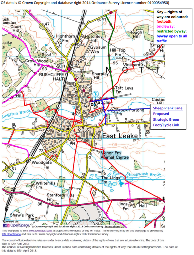
List of Public Rights Of Way in East Leake
On the definitive map of public rights of way, each path in a parish is given an official reference number. The thirty‐two paths in the parish of East Leake are listed below. Most paths continue beyond the parish boundary as a path with a different number in a neighbouring parish. West Leake, Gotham, Bunny, Rempstone, Hoton and Stanford can all be reached from East Leake by public footpaths and bridleways.
Most of these are footpaths (FP) with rights of way on foot only. Numbers 6,15 & 16 are bridleways (BW) with rights of way on foot, cycle and horseback. Numbers 11 and 12 are byways open to all traffic (BOAT’s). No 30 is a Restricted Byway (RB) restricted to pedestrians and non‐motorised vehicles –except for access
- FP1. From the end of Mill Lane (top of Castle Hill) round animal centre towards the site of St Peter’s Churchyard. Meets parish boundary with Rempstone and Costock just beyond the bridge over the Sheepwash Brook. Continues across the field to Rempstone as FP1 (Rempstone) FP2. From top of Castle Hill running west through fields behind Potters Lane to junction with FP5 at kissing gate.
- FP3. From Gypsy Lane round to the right of Home Farm to A6006. Continues to Hoton and Stanford as BW12 (Rempstone).
- FP4. From south of Rempstone Road (continuation of FP5) to Goulds Barn then across the field to the brook at the parish boundary. Continues over the bridge and the next field as FP1 (Stanford) to A6006 at Stanford Crossroads.
- FP5. From Burton Walk. Between Nos 36 & 38 and through the kissing gate into fields. Downhill along hedge side across Sheepwash Brook, through two more fields to emerge on Rempstone Road opposite FP4.
- BW6. From Woodgate Road just beyond the railway bridge to Calke Hall Farm Kennels. Continues to West Leake as BW8 (West Leake)
- FP7. From West Leake Road to Calke Hall Farm to join BW6. This is the access road to Calke Hall Farm, it is also a public footpath.
- FP8. From Birch Lea off West Leake Road (just beyond railway bridge) between houses, through gate into fields, cross field to bridge and uphill to gate which is boundary with West Leake. Continues as FP6 (West Leake) up Foxhill, then to West Leake or Gotham via edge of Golf Course.
- FP9. From Main Street to the right of Manor Farm Meadow to the entrance of Meadow Park. Continues through Meadow Park as Kingfisher Walk to Nixon Walk.
- FP10. From the main entrance to Meadow Park, alongside the recreation field to Gotham Road near the car park.
- BOAT 11. Lantern Lane from junction with Manor Road to the right angled bend to the left.
- BOAT12. Sheep Plank Lane. From Costock Road to Lantern Lane (BOAT 11)
- FP13. From Costock Road between Nos 19 & 21 round the back of No 21 and across the field to junction with Sheep Plank Lane (BOAT 12) at the bridge over Kingston Brook.
- FP 14. From the junction on east side to Sheep Plank Lane to the new path round the School playing field to the junction with Lantern Lane.
- BW15. From parish boundary with Gotham on Gotham Moor, (a footbridge west of the old railway line) to the tunnel under the old railway. Continues west to Gotham as BW8 (Gotham). Continues east to Bunny as BW17 (Gotham) and BW9 (Bunny).
- BW16. Stocking Lane. From Gotham Road, north of the railway bridge uphill past the Golf Club to the parish boundary with West Leake at Crow Hill Wood. Continues to West Leake as BW5 (West Leake and to Gotham as BW11 (Gotham).
- BW17. From Rempstone Road between Nos 27 & 29 to Bley Avenue between Nos 18 & 19.
- FP18. Between The Green and School Green near Brookside School.
- FP19. Along Gypsy Lane from the end of FP3 to the north entrance of Home Farm.
- FP20. From Main Street (to the right of the old Police Station) across the bridge over the Sheepwash brook to join FP 9 before Meadow Park.
- FP21. From the Nook to Potters Lane at No. 55.
- FP22. From Kirk Ley Road between Nos. 41 & 43 to Bley Avenue between Nos. 10 & 11
- FP23. Between Woodgate Road (No. 64) and Orchard Close (No. 17).
- FP24. From Ryholme Close between Nos 11 & 12 to Sharpley Drive between Nos 56 & 58.
- FP25. Frank Kirk Way from Meadow Park (junction with FP9) under the railway, alongside Kingston brook to
junction with FP8. - FP26. From Carlton Crescent (off Stonebridge Drive) between Nos 61 & 63 alongside the boundary fence of the school buildings to the junction with BOAT12 (Sheep Plank Lane).
- FP27. Cuts across the fields from Lantern Lane (BOAT11) opposite the junction with Sheep Plank Lane (No 12) to the junction with Byway 30 opposite Taft Leys.
- FP28. From junction with RB30 at Taft Leys to Hill Top Farm and round the fields to parish boundary with Costock. Continues as FP6 (Costock) to Bunny.
- FP29. Cuts across the field from junction with RB30 at left bend at the bottom of Hotchley Hill. It comes out onto Bunny Lane. Continues to Bunny FP18.
- RB30 (Restricted Byway). Continuation of BOAT11 over Hotchley Hill to Bunny Lane at Welldale Farm.
- FP31. The Nook from Bramley Close to Burton Walk.
- FP32. From Bunny Lane opposite the end of FP29 diagonally across field to parish boundary. Continue as Bunny FP7.
If you find any problem with any of these rights of way then contact the Rights of Way Team at Nottinghamshire County Council quoting the number of the path. Phone 0300 500 80 80.
Other important connecting paths which form part of the strategic network
- The path that goes down the middle of the Trees estate, along the ends of Ash Walk, Poplar Avenue, Willow Close, Beech Avenue, Pine Close and Oak Crescent.
- The connection between Oak Crescent and Brookside Avenue.
- The path along the side of the Village Hall and Parish Office connecting Main street to the Gotham Road car park.
- The path from Station Road alongside the wall by the churchyard. It goes across the end of Church Close alongside numbers 8 and 5. It then goes across the end of Winchester Close by numbers 6 and 9. There is an important connection here between Manor Farm Meadow numbers 44 and 45 and Winchester Close. The path then goes on to the end Southwell Close by numbers 2 and 10. Again there is an important connection between Manor Farm Meadow numbers 34 and 35 and Southwell Close. The path continues from Southwell Close to come out on Bateman Road at number 30.
- The grass track which connects two branches of Manor Farm Meadow. It follows a westerly direction from number 21 to number 26 going along the backs of 22 to 25.
- The path connecting two parts of Bateman Road via the end of Truro Close. It starts between 15 and 17 Bateman Road, goes along the end of Truro Close by numbers 9, 11 and 20 and emerges onto Bateman Road again between numbers 77 and 79.
- A path between Harefield and Brookfields Way on the Gotham Road Estate.
- Connectors off the cul-de-sacs on Stonebridge Drive that lead onto Footpath 10a along the school boundary fence.
- A path at the end of Stonebridge Drive that connects with BOAT12 (Sheep Plank Lane) [note: BOAT – a highway over which the public have a right of way for vehicular and all other kinds of traffic but which is used by the public mainly for the purposes for which footpaths and bridleways are used (i.e. walking, cycling or horse riding)].
4.2 Support for Public Transport
Objectives
4.2.1 Work with Nottinghamshire County Council, Rushcliffe Borough Council, and public transport operators to maximize the new opportunities for travel by public transport offered by the opening of the extension of Nottingham’s tram network and associated park and ride site at Clifton.
4.2.2 Work with relevant Local Authorities and public transport operators to ensure that the current travel opportunities offered by the Nottingham – Loughborough bus service are not reduced.
4.2.3 Work with community transport providers, including the Soar Valley bus and the East Leake Community Care volunteer driver provision to improve the transport network. Recognise the contribution of taxis licensed by the Borough Council.
Key Points
4.2.4 Improvements to evening public transport services for access to social and cultural activities outside the village in Nottingham and Loughborough.
4.2.5 Improvements to public transport links with surrounding villages that use East Leake as a hub; with other centres such as Clifton, Wilford, and Ruddington, and with locations such as East Midlands Airport which lie outside the Nottingham – Loughborough corridor.
Policy T3: ‐ Public Transport
Developments in the plan area will be required to contribute, where appropriate, through Section 106 Agreements, section 278 Agreements, Community Infrastructure Levy and direct investment or works, to secure improvements to public transport services, which provide new travel opportunities to access work, health and other public services, shopping and leisure facilities.
Justification
4.2.6 National Planning Policy Framework [NPPF] paragraph 35 states plans should protect and exploit opportunities for the use of sustainable transport modes for the movement of goods or people.
4.2.7 Nottinghamshire Local Transport Plan 2011‐2026: the transport vision states:
“The long‐term transport vision for Nottinghamshire is at three spatial levels: […]
2. To provide everyone with safe and sustainable transport options for movement within and between our towns and district centres. This will include a fully integrated, high quality public transport network and appropriate parking provision for private cars
3. To connect our towns, district centres and villages to other parts of the Plan area and beyond (including regional and national trip generators). This will include safe and sustainable strategic links by road and rail for both people and goods.”
4.2.8 Rushcliffe Borough Council Core Strategy [RBC, CS]
- Policy 14 seeks to provide improvements to public transport services, walking and cycling facilities that are provided early in the build out period of new developments and that are sufficient to encourage sustainable modes of transport.
4.2.9 Report on East Leake Community Survey (2012) [ELCP]
- 66% rate the frequency of evening bus services as poor
- 76% rated improving local transport links in the top 2 priority categories for allocating financial resources available from new developments in the village.
4.2.10 East Midlands Airport Sustainable Development Plan 2015
- Economy and Surface Access Plan states that the Airport will continue to work in partnership with others to secure improvements to public transport services to the airport including a new route from South Nottingham via East Leake
- The Airport’s Employee Survey records that 404 people working on the Airport site live in Rushcliffe district, which represents 1 in 137 of the Borough’s working population.
4.2.11 Analysis of 2011 Census Neighbourhood Statistics shows high levels of car ownership and a higher than average proportion of people who drive to work, highlighting the unsuitability of public transport for journeys to work.
4.2.12 British Gypsum commissioned an internal commuting survey in July 2013, which indicates that many more of its employees would choose to walk, cycle or get the bus to the site if the routes/safety etc were better. (Report is available on request.)
4.3 Wider Transport Infrastructure Considerations
4.3.1 The following transport infrastructure items need to be addressed by other bodies in the context of future development in and around East Leake:
- The existing congestion at rush hour on the A60 into Nottingham
- The accident record on the A6006 between Hathern and Rempstone
- The traffic impact of the Stanford Hall development (Defence and National Rehabilitation Centre).
- The impact of the Clifton expansion on the travel to work journey into Nottingham from East Leake.
- The impact of East Leake housing on the routes from East Leake to the M1, A453 and the Nottingham ring road, via Bunny, Gotham, West Leake etc.
- Consideration of a mainstream network rail link and station for East Leake.
- Provision for rail and NET2 interchange at Ruddington.
- Provision for long distance and commuter cyclists.
Section 5 - Maintaining the Environment
Vision: We wish to conserve and enhance the rural character of the village, and to preserve the ring of green undeveloped hills surrounding the village. Further, we intend to exploit and enhance the network of informal green spaces within the village, so that they support attractive pedestrian and cycle routes connecting the different parts of the village.
5.1 Containment of the Built Environment
Objectives
5.1.1 Maintain the rural aspect of the village by preserving views of the surrounding ring of green ridges.
5.1.2 Ensure that areas of open countryside surround the village and separate it from neighbouring settlements.
Key Points
5.1.3 It is very clear from the responses to the Community Plan questionnaire [ELCP 2.1, 6.2, 10.1] that a significant proportion of residents value the current rural character of East Leake, and to feel close to open countryside. In that respect the undeveloped ridges surrounding the village to the south, west and north are important in providing views of countryside for many properties. Also, to a
certain extent, the ridges screen sight of East Leake from outside the village. Containing the settlement within this bowl is critical to maintaining the rural aspect. The heights of any buildings within the Parish boundary on the slopes up to the ridges will be limited so as to leave a suitably sized green rim clearly visible from the village and to screen sight of the village from outside. The four ridges are described below and shown on the map at Fig. 5.1/1.
Ridge A
Ridge A runs along Rempstone Road in a WNW direction, and then swings in a more westerly direction past Calke Hall Farm. It is believed that this is the line of an old Roman Road. This ridge is the dominant southern view from the West Leake Road.
Ridge B
Ridge B rises from West Leake in a NE direction, just NW of the Parish boundary. It then swings almost ESE, falling towards British Gypsum works. This ridge, loosely known as Fox Hill, dominates the NW views from the village centre and the northern view from West Leake Road.
Ridge C
Ridge C is the closest to the village centre, and runs almost parallel to Ridge A. It stretches from behind the top of Burton Walk, across the ancient ‘ridge and furrow’ fields by Castle Hill, then just north of Manor Farm towards Rempstone. Because of its height it hides the SE section of Ridge A from the centre of the village. It is a clear southern ridge when viewed from Costock Road.
Ridge D
Ridge D dominates the skyline to the north of Costock Road. It starts well to the east of the parish near Bunny Wood, follows due west along Ash Lane past Hill Top Farm. As it reaches the NE corner of the village, it swings north around Hotchley Hill. This ridge, together with Ridge B, forms an important partial E – W wildlife corridor in the north of the parish.
5.1.4 Of equal importance is the need to maintain clear separation from neighbouring settlements. Notably this applies to Costock to the east, West Leake to the west and Gotham (The Ridgeway) to the north. The amount of undeveloped land remaining within the parish boundary in each of these directions is limited. Some protection in this regard is provided by policy H6(a) (c) in Section 2.5 above, other policies protecting green space, playing fields and allotments, and the green belt protection in the north of the Parish. It is considered unlikely that East Leake will coalesce with adjoining settlements during the plan period.
5.1.5 The network of footpaths and bridleways that provide access into the countryside make it a valuable leisure amenity for residents. (See section 4.1 and policy T1 for more on this).
5.1.6 The railway line to the west of the built up area of East Leake also forms an important green boundary to the village, being mostly visible strong embankment or cutting, and acting as a wildlife corridor. Along much of its length the railway is a boundary to the built up area and Policy E1(b) promotes this for the future. The main exception where there is existing development to the west of the railway line is West Leake Road. The character of the development here is linear and relatively sparse, and this should be a planning consideration in future applications.
Policy E1 – Containment of Built Environment
- The ridges within the Parish boundary marked on the map at Fig. 5.1/1 will remain undeveloped, in order to maintain the rural character of the village and to provide a visual link between the settlement and the countryside. The heights of any buildings within the Parish boundary on the slopes up to the ridges will be limited so as to leave a green rim clearly visible from the village and to screen sight of the village from outside.
- Development to the west of the railway line, other than on West Leake Road, will be permitted only where strong justification is provided. On West Leake Road, any development should have regard to the more linear and sporadic residential character of the area.
Justification
5.1.7 [NPPF] para 110, on allocating land with the least environmental or amenity value for development.
5.1.8 Rushcliffe Borough Council Core Strategy [RBC CS] policy 15, protecting and enhancing green infrastructure, particularly 2(e), protecting landscape character.
5.1.9 The Greater Nottingham Landscape Character Assessment 2009, provides a way of assessing the varied landscapes within Greater Nottingham and contains information about the character and condition of the landscape to provide a greater understanding of what makes the landscape within Greater Nottingham special. Within the Nottinghamshire Wolds character area the relevant assessments for the East Leake are: NW01 Gotham and West Leake Hills and Scarps; and NW02 East Leake Rolling Farmland. These describe the valued features of the landscape, including the following statements:
- large commuter settlements such as Gotham and East Leake … are nestled at the base of the hills
- The strength of character is STRONG. The hills are distinctive and consistent features across the landscape and exert their influence within the surrounding area.
5.1.10 From the East Leake Community Plan Survey report [ELCP]:
- In Fig. 2.1, 50% use Local public footpaths / bridleways often, 40% sometimes
- In Fig. 6.2, 96% agree to some extent that “the network of footpaths/bridleways from East Leake and out into the countryside is important to me”
- In Fig. 10.1, the most popular parting thought on the “best thing about living in East Leake” was “Access to countryside / rural setting” with 107 mentions, 28% of the total for this question.
5.1.11 Policy E1(a) which deals with views of ridges, is supported by a Views Assessment produced by the Neighbourhood Plan Group. This document can be found on the Neighbourhood Plan Web site.
Fig. 5.1/1 Undeveloped Ridges Surrounding East Leake
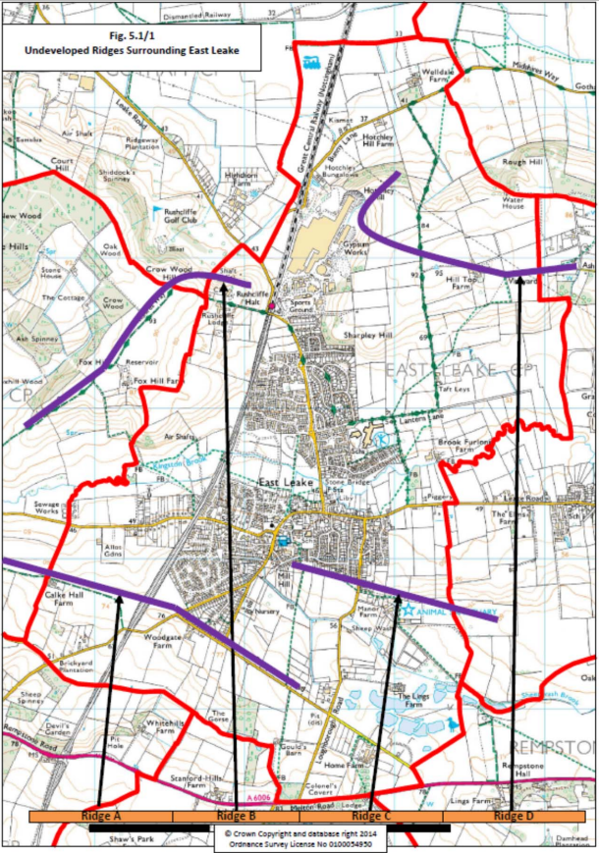
5.2 Preservation of Wildlife and Rural Heritage, Policy
Objectives
5.2.1 Preserve, and where possible enhance, continuous green corridors for the movement of wildlife.
5.2.2 Preserve heritage agricultural features.
5.2.3 Increase the presence of mixed woodland.
5.2.4 Bring wildlife into new housing developments.
Key Points
5.2.5 Implicit in the rural character of the village and its surroundings are the preservation of suitable green corridors for wildlife, and heritage agricultural features. Continuous green corridors are important for the movement of wildlife. Existing green corridors which must be preserved and, where practical, extended or enhanced are:
- the east / west flood plain along Kingston Brook (see Fig. 2.5/2), including the historically significant osier bed along its course through the parish,
- the course of the Sheepwash Brook,
- the Site of Importance for Nature Conservation (SINC) along the railway line (south west / north east), and
a partial east / west corridor starting at Bunny Woods, passing through woods on Ash Lane, linking to Hotchley Hill and Rushcliffe Golf Course (the latter two in the parish). It should be noted that the golf course, although mostly just outside the parish, is a nationally recognised Site of Special Scientific Interest (SSSI).
An important future wetland resource, which will be created as the Cemex gravel extraction at Lings Farm winds down, should also be preserved and enhanced. It will be located close to the abandoned St Peter’s churchyard, which itself has great wildlife potential, albeit just outside the parish boundary.
5.2.6 Equally, heritage features such as mature trees, ancient hedgerows and increasingly rare semi‐improved pastureland, typified by ancient ridge‐and‐furrow, are important habitats which should be protected from development. Ancient ridge and furrow earthworks are a diminishing resource within Rushcliffe’s historic environment and should be preserved both for their historic and biodiversity value.
5.2.7 Discussions with Nottinghamshire Wildlife Trust and feedback from Rushcliffe’s Environmental Sustainability Officer have indicated that mixed native woodland, wetland habitats, and species‐rich grassland are all underrepresented in East Leake’s section of the National Character Area 74 (Leicestershire and South Nottinghamshire Wolds), and opportunities should be sought to rectify this when possible.
Policy E2 – Green Infrastructure: Wildlife and Rural Heritage
- The green corridors and Local Wildlife Sites [note: Local Wildlife Sites, as defined by the Nottinghamshire Local Wildlife Sites Handbook are sites of local importance
for the conservation of biodiversity. Previously known as Sites of Importance for Nature Conservation (SINCs)] marked on map at Fig. 5.2/1, and the flood plain of the Kingston Brook and course of the Sheepwash Brook (see Fig. 2.5/2) will be maintained and enhanced, in order to support the rural character of the village. - Agricultural heritage features will be protected, for the benefit of both residents and wildlife.
- Opportunities will be sought to plant additional mixed woodland (using native tree species of local provenance), wetland habitats and species‐rich grassland.
- Any housing developments should incorporate, where appropriate and practical, roosting opportunities for bats and birds.
Justification
5.2.8 NPPF, para 117 deals with wildlife corridors, para 109 with biodiversity
5.2.9 Rushcliffe Borough Council Core Strategy [RBC CS] policies 15 (green infrastructure) and 16 (biodiversity) and feedback from Rushcliffe’s Environmental Sustainability Officer
5.2.10 Greater Nottinghamshire Landscape Character Assessment ‐ see 5.1.9 above
Fig. 5.2/1 Local Wildlife Sites
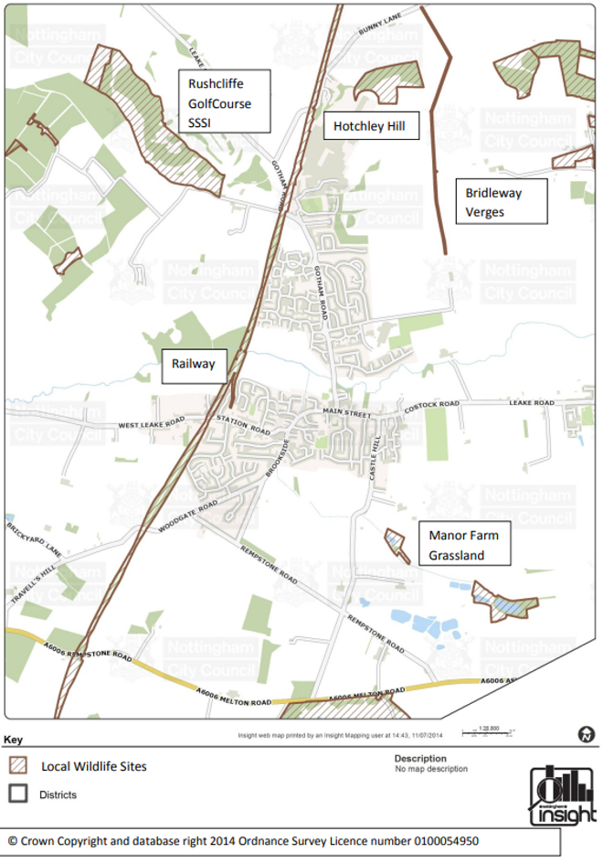
5.3 Green Spaces, Policies
Objectives
5.3.1 Preserve existing green spaces in the village and include green spaces in new developments, ensuring they are maintained.
5.3.2 Bring the countryside into the built environment wherever possible.
5.3.3 Soften the village centre with planting.
Key Points
5.3.4 Rural character, for most people, is defined not only by surrounding countryside but also by the introduction of green spaces and trees within the built environment. This is typified currently by the area around the village green (near the Church), the area along Station Road (including many mature trees), the Rest Garden in the centre of the village, and Meadow Park. Some newer housing
developments have incorporated green spaces which have been planted with trees (e.g. Manor Farm Meadow), and others contain a variety of open green areas (e.g. Trees estate, Bley Avenue, Rushcliffe Estate).
5.3.5 All new housing developments should incorporate imaginative green spaces, with a focus on native tree planting to improve the habitat. Opportunities presented by any redevelopment of the village centre should also incorporate suitable planting to offset the harsher built environment, with a focus on wildflower and native tree planting to improve the habitat.
Policy E3 – Green Infrastructure within the Built Environment
- The value of open spaces within existing housing areas will be rigorously balanced against the gain from any planning applications to develop them.
- All new developments should incorporate suitable green spaces for the benefit of wildlife and the recreation of residents. Suitable arrangements must be incorporated for the costs of future maintenance of these “green lungs”.
- Effort should be made to develop both current and future pedestrian routes between the village and the surrounding countryside into mini green corridors, to help bring the countryside into the built environment.
- All developments within the village centre should seek to incorporate tree and shrub plantings to enhance the appearance. Due regard must also be paid to enhancing planting throughout the Conservation Area where possible.
Policy E4 – Designated “Local Green Spaces”
The following existing green spaces (see Fig. 5.3/1) are designated as “local green space” as defined in the National Planning Policy Framework, paragraphs 76 to 78, and protected accordingly. New development in these spaces will be permitted only in very
special circumstances.
- Meadow Park (for recreation and wildlife)
- Village Green and memorial gardens (history, remembrance, community gatherings, and tranquillity)
- Townlands Trust ridge and furrow field from railway to Gotham road (history, visual amenity)
- Ridge and furrow fields at the back of Potters lane (history and recreation via footpaths 2 and 5)
- Rest Garden (tranquil outdoor community space in village centre)
- The Glebe (tranquil green space at heart of conservation area)
Justification
5.3.6 Further information on the sites is provided in a separate document, “Assessment of Areas Identified as Local Green Space” in the evidence base on the Neighbourhood Plan website.
5.3.7 [NPPF] para 58 on green space as part of developments, paras 76‐78 on local green space designation; para 109 biodiversity, para 114 green infrastructure
5.3.8 Rushcliffe Borough Council Core Strategy [RBC CS] Policy 15, section 2 and3 on green infrastructure, section 4 parks and open space.
Fig. 5.3/1 Local Green Space
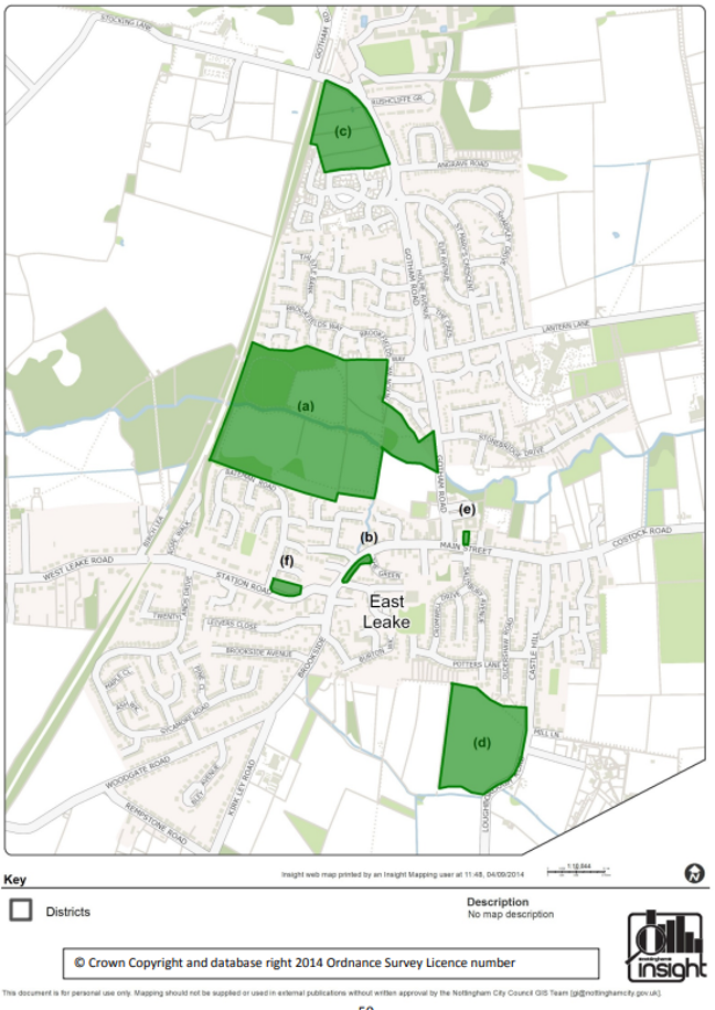
Section 6 - Leisure and Play
Vision: We wish to promote healthy lifestyle choices for all and improve facilities for young people, and in particular
provide more activities for teenagers.
6.1 Playgrounds and Playing Fields
Objectives
6.1.1 Provide neighbourhood and village centre play facilities for young people of all ages and abilities.
6.1.2 Support the continued operation and enhancement of the playing fields at the Leisure Centre, Costock Road and schools as the village grows.
Key Points
6.1.3 East Leake is a thriving community with a range of leisure facilities, clubs, sports etc. for all ages. Most of these fall outside the remit of the Neighbourhood Plan which focuses on planning matters. However sport and children’s playgrounds can be influenced by planning.
6.1.4 The Leisure Centre provides excellent facilities for residents, including a swimming pool, and is operated via a PFI agreement [note: PFI – Private Finance Initiative, i.e. funding public infrastructure projects with private capital]. The Costock Road playing fields are in need of funding for enhancement and extension; this is being catered for via a nominated sum per new home (or other provision, such as providing parking) in S106 agreements for housing developments as they go through planning. The Neighbourhood Plan therefore supports the continuation of this approach, and protects the Costock Road playing fields as open space, but takes no further measures.
6.1.5 Play facilities, however, are seen as being in need of improvement. The Parish Council has a vision for playground facilities in East Leake and is focused on providing a main large, modern and challenging play area in the centre of the village for all ages and abilities. New housing developments should have open play space for free play, kick‐about etc., and possibly a small amount of onsite play equipment provision, particularly for younger children. An equipped and fenced area for under 5s in the central area is needed for groups such as nurseries and playgroups as well as for families.
6.1.6 The vision is for East Leake is to be developed as a “walking village” – with emphasis on footpaths and cycle paths that connect the areas of housing to facilities and services in the centre of the village, to discourage unnecessary use of cars. The Gotham Road play area is in the heart of the village, open and clearly visible, and is provided with public conveniences, shops and cafes for refreshments, and good car parking facilities for those who need them. There is a large area of open space nearby, with future plans to develop seating and further picnic areas for use by families. The play area provides productive activities for older children and teenagers using the facility independently, including a recently constructed skate park, a multi use games area, and an informal sports pitch.
6.1.7 Families pass through the centre of the village on school journeys, for shopping, Health Centre appointments, and use of the Library. A visit to the play area is a natural part of the activity. A social hub develops, where families can meet and interact. This in turn encourages use of the local shops and supports the economy.
6.1.8 Policy L1 (a), therefore, directs the larger share of contributions from developers to fund play equipment provision towards enhancing the central play area.
6.1.9 The Oldershaw Trust playing field on Costock Road is a long standing provision that provides an alternative, quieter, high quality free play area, particularly for children living in that part of the village. The vision is for this to continue to be equipped for ball play with possibly a small amount of play equipment.
6.1.10 Exercise equipment for adults and older people are also important (e.g. trim trail, outdoor gym) and opportunity will be taken where possible to enhance this provision throughout the village.
Policy L1 – Playgrounds
- Housing developer contributions for play equipment will contribute towards the development and upkeep of the main large, modern and challenging play area in the centre of the village for all ages and abilities.
- New housing developments should also have open play space for free play, kick‐about etc., and possibly a small amount of onsite play equipment provision for younger children.
- The following open spaces are important for sport and recreation and protected in line with paragraph 74 of the National planning Policy Framework: Costock Road Playing Fields, Oldershaw Trust Playing Field, Gotham Road Recreation field [note: Excluding the area immediately adjacent to the car park, currently occupied by the infant play area, planned to be used to extend
the car park], schools’ and leisure centre playing fields.
Justification
6.1.11 East Leake Community Plan survey [ELCP]: Fig. 6.2, 70% thought children’s play facilities were in need of improvement, Fig. 11.9 shows 59% of young people responding thought that playground equipment should be improved
6.1.12 Appendix 7 of the East Leake Neighbourhood Plan Statement of Consultation (in a separate file linked from east‐leake.gov.uk/neighbourhood‐plan) documents a separate consultation about playground facilities, undertaken by a Parish Council working party in conjunction with the Community‐led plan. This received 105 responses demonstrating clear support for refurbishment of the Gotham Road playground to provide a stimulating community based play facility. The Parish Council is currently progressing this plan, which will see the current infant play area move within the Recreation Ground, and much needed additional parking provided
for the village centre (see also section 8).
6.1.13 Policy L1 is in accordance with East Leake Parish Council playground policy, approved on 28/1/14.
6.1.14 Paragraphs 73 and 74 of the NPPF deal with open space for leisure and recreation with paragraph 74 describing how it is protected.
6.1.15 Rushcliffe Borough Council’s play strategy is guided by the Fields in Trust National Play Standards, which states: “Provision for children and young people should be located where they will be accessible on foot or by bicycle. The ‘effective catchment’ of a play space may be defined as the distance travelled by 75% of users.”
The standard defines a hierarchy of provision: Local Areas for Play (LAP) within a walking distance of 100m; Local Equipped Areas for Play (LEAP) within 400m; and Neighbourhood Equipped Areas for Play (NEAP) within 1000m. Policy L1, when taken in conjunction with H6(a) which specifies a maximum walking distance for new developments from the village centre, and T1 and T2 which promote safe routes for pedestrians and cyclists, is seen to be consistent with this hierarchical approach.
6.1.16 The following Rushcliffe Borough Council documents are relevant:
6.2 Allotments
Objectives
6.2.1 Protect existing level of allotment provision
6.2.2 Encourage further provision of allotments as the village expands
Key Points
6.2.3 “Allotments are valuable green spaces and community assets providing people with the opportunity to grow their own produce as part of the long‐term promotion of environmental sustainability, health and well‐being, community cohesion and social inclusion.” Note: Andrew Stunell MP, in Standard Note SN/SC/887, Allotments, 22 March 2012.
6.2.4 East Leake allotments lie on the outskirts of the village on West Leake road. There are currently 93 plots varying in size. The allotments are owned and governed by the Diocese of Southwell and Nottingham and managed by East Leake Allotment Association.
6.2.5 In addition to the social, health, and sustainability benefits of allotments in general, this particular site is a tranquil setting for the neighbouring burial ground, provides a pleasing green space at the approach to village, contributing to separation from West Leake.
6.2.6 At least one of the housing sites presently under development is proposing to include provision of allotments, and policy L1(a) encourages future development applications to do likewise.
6.2.7 The Small Holdings and Allotments Act 1908 imposes a duty on councils to provide allotments if six or more people say that they want them. Building on such publicly owned allotment land is only permitted if the allotment holders are offered alternative sites. Policy L1(b) extends similar protection to established allotment sites which are not in public ownership.
Policy L2 – Allotments
- New housing development proposals should, where feasible, and where community demand can be demonstrated, include provision of suitably serviced allotments.
- Proposals that would result in harm to or loss of existing allotments will not normally be permitted unless:
- replacement provision is made, of at least equivalent quality, and located at reasonable convenience for the existing plot holders;
- a significant and ongoing vacancy rate of existing allotments can be demonstrated;
- exceptional significant social, economic and environmental community benefits would be derived from the proposal.
Justification
6.2.8 As of September 2014, there are 3 vacant plots on the allotment site, following a push by the group to encourage people no longer actively using their plots to give them up.
6.2.9 Although not explicit in the NPPF, government emphasises the value of allotments and the role of Neighbourhood Plans in promoting them. Note: Standard Note SN/SC/887, Allotments, 22 March 2012.
6.2.10 Exeter St James and Felpham Neighbourhood Plans (made) are among a number that include similar policies on allotments.
Section 7 - Conservation History and Heritage
Vision: We wish to maintain the character of East Leake as a place with a strong sense of community and history.
Objectives
7.1.1 Conserve the historic centre of East Leake village.
7.1.2 Preserve the rural and agricultural heritage across East Leake parish.
Key Points
7.1.3 The built area of East Leake has an established conservation area and associated management plan. Originally covering only the area around St Mary’s Grade 1 Listed Church and associated roads, it was extended in 2008 to incorporate the remainder of Main Street. This was to accommodate the historic basket‐works cottages on Costock Road at the eastern end of the village centre. Instead of
creating second Conservation Area, the decision was taken to create a single large area. The Conservation Area documents are regularly reviewed (once every 5 years), and all planning applications within the conservation area will be rigorously checked to ensure that they preserve or enhance the character of the area rather than detract from it. No additional policies are necessary in the Neighbourhood Plan to enable this. (Section 8.1.9 below also mentions historic buildings in the Village Centre.)
7.1.4 Rural and agricultural heritage is covered in section 5.2 and in policy E4. Policies E3 and E4 cover green spaces within the conservation area.
Further Information
7.1.5 Further Information is contained in the following:
- East Leake Conservation Area Appraisal and Management Plan,
- East_Leake_Townscape_Appraisal_Plan.pdf
- East Leake Conservation Area Boundary ‐ Map
East Leake Conservation Area
Fig. 7.1/1East Leake Conservation Area
Section 8 - Village Centre
Vision: “We are concerned that at present the shopping centre is something of a muddle. We will endeavour to improve the quality of the entire public area in the village centre by making it more pedestrian‐friendly and safer, resolving car parking problems, reducing traffic dominance and radically improving the quality of building design and materials. We will also encourage retention and widening of
the range of shops and facilities that serve the needs of the community.”
8.1 Priorities for Land Use in the Village Centre
Objectives
8.1.1 Ensure, in the area of the village closest to essential services, priority is given to development that has particular need of this prime location. See Fig. 8.1/1 for the extent of the area in question. Encourage types of development not requiring a village centre location to use parts of the village further out from the centre.
8.1.2 Improve the quality of buildings in this area over time, thus improving the character and atmosphere of the village centre.
Key Points
8.1.3 Retail outlets and other services and businesses requiring a “shop front” are best located in a compact cluster within easy walking distance of each other, to facilitate use via walking journeys by local people, to reduce car journeys, and to provide access by public transport.
8.1.4 Space to develop the village centre is at a premium, and as additional housing is built this will become a pressing need. Space that is close to the village centre, within easy walking distance and at a level gradient, is needed for a variety of purposes.
8.1.5 Redevelopment of the Health Centre building (in situ) or its replacement (on a new site in the village centre) is urgently needed as the existing building has reached end of life and cannot provide the range of healthcare facilities that the village needs. Dentist surgeries and private ancillary health services also need a village centre location, as do the library and community buildings including places of worship.
8.1.6 Additional car parking is needed – the existing car parks are operating at capacity causing problems from inappropriate on‐street parking. Bicycle and motorcycle parking provision needs to be improved, and provision for electric cars will be needed in the future.
8.1.7 As the village grows the population should benefit from a wider range of shops and services, and these need to be accommodated.
8.1.8 Homes for older people and others with reduced mobility need to be close to the village centre with a short level walk to facilities such as shops, post office, Health Centre, dentist, vet, optician, and public transport. Family homes (3 bedrooms and over), on the other hand, are better located out of the immediate village centre area. There is some scope for provision of more mixed residential accommodation in flats above shops, offices and other ground floor services in the village centre, particularly where “living above the shop” would be beneficial.
8.1.9 It is recognized that the area contains a number of historic buildings and green areas which contribute positively to the character of the village; these are valued and should be preserved and/or enhanced.
Policy V1: Priority Uses for Village Centre
- In the area defined as the East Leake Village Centre (see Fig. 8.1/1) the only types of new development permitted will be those that particularly require this village central location. Such development types include: community services, health services (in both cases falling within Use Class D1), retail outlets, other businesses and services requiring a “shop front” (in both cases falling within Use Classes A1, A2 A3, A4), car and bicycle parks, housing for older people, those with mobility problems, and situations where “living over shop” is appropriate (with such use for these homes preserved over time), social and leisure space (i.e. Use Class D2).
- Development proposals, including replacement buildings, in the East Leake Village Centre should be of an appropriately high quality design, using materials sensitive to the local context. The scale and proportions of the buildings should be sympathetic to their surroundings and complement the unique historic character of East Leake, having due regard to the Conservation Area.
- All village centre development proposals that involve change of use should include an assessment of the impact on village centre parking.
- Developments for purposes other than those listed in (a) above, or requests for change of use away from those listed, must provide a strong justification for a village centre location.
Justification
8.1.10 In the East Leake Community Plan survey [ELCP]:
- On transport and the environment and village centre (summarized in Figures 1.8 and 2.4), “car parking emerged as a salient issue with 15% of those who made a comment [on environment] complaining about inadequate parking facilities and inconsiderate parking.” “Other prevalent concerns centred on the standard of landscaping and maintenance of the green areas throughout the village and the appearance of the village centre (in particular the exteriors of shops, which many felt need maintenance and updating).”
- In comments about business, “the vast majority of respondents (96%) said they shop within the village, but 38% disagreed with the statement the village has a good variety of shops and businesses and 30% disagreed that the local shops are well stocked with my daily / weekly requirements.
- In comments about Health and Social care “when asked what additional health and social care services they would like to see in East Leake, a large proportion of respondents (41% of those who made a comment in response to this question) took the opportunity to complain that the existing Health Centre is, in their view, too small and in need of modernization (Figure 8.3). There were also requests for specialist clinics and services such as physiotherapy, diabetes clinics, minor surgery, etc.”
8.1.11 The Rushcliffe Core Strategy [RBC, CS] recognises the importance of access to services and community cohesion in providing sustainable locations for development.
- “The settlements of Bingham, Cotgrave, Ruddington, East Leake, Keyworth, Radcliffe on Trent and West Bridgford will each accommodate new development to maximize their accessibility to services and infrastructure.” [2.4.1 ii]
- “It is important that all centres act as a focus for community life where residents can live, socialize and help to strengthen social cohesion. To maintain this, it is vital to preserve, and where needed, add to the diverse range of (predominantly) retail facilities already present within them.” [3.1.5.2]
8.1.12 In section 2, para 23, “Ensuring the Vitality of Town Centres”, the National Planning Policy Framework [NPPF] states:
“Planning policies should be positive, promote competitive town centre environments and set out policies for the management and growth of centres over the plan period. In drawing up Local Plans, local planning authorities should:
- recognize town centres as the heart of their communities and pursue policies to support their viability and vitality; …
- define the extent of town centres and primary shopping areas, based on a clear definition of primary and secondary frontages in designated centres, and set policies that make clear which uses will be permitted in such locations;
- promote competitive town centres that provide customer choice and a diverse retail offer and which reflect the individuality of town centres;…”
8.1.13 The Evidence Base on the East Leake Neighbourhood Plan Web page includes a report of three surveys undertaken in 2012‐14, showing high occupancy rates of village centre car parks.
Fig. 8.1/1 East Leake Village Centre – Designated Area for Prioritising Village Centre Use
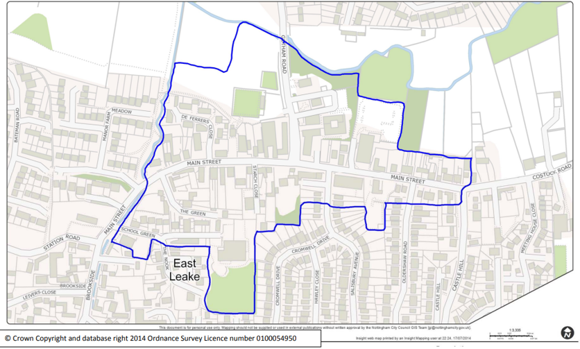
8.2 Improvements to the area of the Gotham Road/Main Street T‐Junction
Objectives
8.2.1 To have in place an agreed set of objectives for the area around the T Junction, against which all planning applications are tested.
8.2.2 Obtain financial contributions, or contributions in kind, from large scale developments to further these objectives, via a scheme to be developed in due course by relevant agencies.
8.2.3 Create a pedestrian‐friendly environment and make the junction less of a barrier and hazard for pedestrians, thereby improving access to all village centre shops and facilities.
8.2.4 Improve the arrangements for pedestrians to cross roads.
8.2.5 Redesign and upgrade the entire public space to create uncluttered spaces surfaced with high quality materials and planting appropriate to a Nottinghamshire village.
8.2.6 Reduce traffic speeds on Main Street, and the number of vehicles on Gotham Road waiting to turn, to enhance safety for pedestrians and cyclists.
8.2.7 Adjust the traffic priority at the T‐junction to favour the dominant traffic flow, thus reducing delays.
8.2.8 If road changes allow this, increase the open pedestrian area on the east side of the shopping area to create a new “village square”, i.e. space for community events, such as Christmas Lights Switch On, Village Fete, markets.
8.2.9 Maintain a village atmosphere and a sense of community to promote social sustainability as the village grows.
Key Points
8.2.10 The village centre does not fully meet the expectations of residents today, and will certainly not be fit for purpose as the village population and traffic continues to grow. Deficiencies in a number of key areas have been identified, namely aesthetic appeal, pedestrian safety and ease of access to shops, traffic management and parking, and safe spaces for community events.
8.2.11 A lively and prosperous village centre, offering the widest possible range of services to residents, is a key ingredient to a sustainable location for housing development.
8.2.12 It is anticipated that a detailed scheme will be produced in conjunction with the relevant agencies and in consultation with retailers and shop owners, at a future time when funding is available to take it forward in full or in part.
8.2.13 Note that any additional space gained would be deliberately concentrated on one side of the road, to provide a useable community space, rather than widening the pavement equally on both sides of the road.
8.2.14 Details such as railings and other street furniture would be considered as part of the detailed scheme.
8.2.15 Complementary developments in the area of the scheme are encouraged. Examples could include:
- Increasing and improving the car parking provision.
- Redeveloping the Health Centre site if a new site is found for the replacement building.
- Moving the entrance to the rear of the shops on the West side of Gotham Road so that it comes through the car park, providing the opportunity to extend the row of shops northwards.
- Improving pedestrian access in the area between the Co‐operative and the Health Centre car parks, round the back of the Health Centre and through the rest garden.
- Relocating the sewage pumping station to a location outside the village centre (long term aim).
Policy V2: East Leake Village Centre Improvement
- All planning applications in the area of Main Street/Gotham Road T‐junction
should further the following objectives, or at least have a neutral effect in this
regard:
• Create a pedestrian‐friendly environment and make the junction less of a barrier and hazard for pedestrians, including those using wheelchairs, mobility scooters, baby buggies etc;
• Improve the arrangements for pedestrians to cross roads;
• Create uncluttered spaces surfaced with high quality materials and appropriate planting;
• Reduce traffic speeds on Main Street, and the number of vehicles on Gotham Road waiting to turn;
• Adjust the traffic priority at the T‐junction to favour the dominant traffic flow;
• Increase the open pedestrian area on the east side of the shopping area to create space for community events. - Developments in East Leake Parish will be required to contribute, (to an extent appropriate to the scale of the development, through Section 106 Agreements, section 278 Agreements, Community Infrastructure Levy, and/or direct investment or works), towards redevelopment of the village centre in accordance with the above objectives.
Justification
8.2.16 The green spot/red spot exercise at the first East Leake Community Plan Drop‐in event in March 2012 [SoC, 3.8] focused a strongly negative response on the T‐junction (i.e. a large cluster of red spots).
8.2.17 More than half of respondents to the East Leake Community Plan survey carried out in 2012 [ELCP] said that additional pedestrian crossings are a ‘high priority’. The most frequently suggested location for an additional crossing was at various points on Gotham Road and among those who specified a particular position along Gotham Road, the most frequently requested location was around the lower end (towards Main Street). A crossing across Brookside/Main Street in the area of “The Offy” has also been mentioned in consultations.
8.2.18 The current priority route at the T‐junction, i.e. along Main Street, does not have the dominant traffic flow. An analysis of peak hours traffic on Friday 20 September 2013, shows this route as the lightest flow (27%), evenly matched with the Main St West/Gotham Road route (29%). 44% of journeys, however, are Gotham Road/Main Street East. Note: See Rushcliffe Borough Council Planning Applications site, application 13/02228/OUT Transport Assessment for the East Leake Costock Road Development. An all day COBA count report on Wednesday 30 September 2009, for Nottinghamshire County Council shows a similar result to above (28%, 28%, 44%). Source: COBA count report for Nottinghamshire County, Communities Department, Traffic Data Collection, Manual Traffic Counts Data for 30 September 2009.
8.2.19 Government guidance on public realm and highway design supports the idea that improvements to the village centre will be beneficial for its economic vitality, and residents’ quality of life. [NPPF, paragraphs 7, 23‐27, 35, 37, 69, 70]
8.2.20 Increasingly, local authorities and others are recognising the benefits of improving the quality of streets for the people who use them. Benefits range from improvements to local economies and quality of life enhancements to encouraging more people to walk and cycle. [SfA]
8.2.21 Manual for Streets [MfS] emphasises that streets should be places in which people want to live and spend time in, and are not just transport corridors. In particular, it aims to reduce the impact of vehicles on residential streets by asking practitioners to plan street design intelligently and proactively, and gives a high priority to the needs of pedestrians, cyclists and users of public transport. Manual for Streets 2 builds on the philosophies set out in Manual for Streets and demonstrates through guidance and case studies how they can be extended beyond residential streets to encompass both urban and rural situations.
Section 9 - References and Abbreviations
9.1 Abbreviations and links for references appearing several times
Footnotes in the sections above give detailed references where necessary, but documents that are referred to several times are listed here and referred in the body of the text by their abbreviation.
BfL
Building for Life 12 ‐ industry standard for design of new housing developments.
ELCP
Report of East Leake Community Plan Survey, 2012.
MfS
Manual for Streets 1 and 2, DfT and Chartered Institution of Highways and Transport.
NCC
Nottinghamshire Local Transport Plan 2011‐2026.
NPPF
National Planning Policy Framework, National Planning Policy Framework, March 2012.
RBC
Rushcliffe Borough Council Core Strategy documents.
RBC CS
Rushcliffe Borough Council Local Plan part 1, Core Strategy, adopted December 2014.
SfA
Streets for All, English Heritage
SoC
East Leake Neighbourhood Plan Statement of Consultation
9.2 Use Classes
The Town and Country Planning (Use Classes) Order 1987 (as amended)77 puts uses of land and buildings into various categories known as 'Use Classes', and these are referred to at various points in this document.
The following list gives an indication of the types of use which may fall within each Use Class. Please note that this is a guide only and it is for local planning authorities to determine, in the first instance, depending on the individual circumstances of each case, which Use Class a particular use falls into. The Use Class Order is subject to periodic change – this summary is from Summer 2014.
| Use Class | Description | Section Mentioning Use in East Leake Neighbourhood Plan |
|---|---|---|
| Class A1 – Shops |
|
3.1 and Policy B1 ‐ Encouraging 3.1.7 – hairdressers already well Policy V1 – Priority Uses for Village |
| Class A2 – Financial and Professional Services |
|
3.1 and Policy B1 ‐ Encouraging Policy V1 – Priority Uses for Village |
| Class A3 – Restaurants and Cafes | For the sale of food and drink for consumption on the premises ‐ restaurants, snack bars and cafes |
- |
| Class A4 – Drinking Establishments |
Public houses, wine bars or other drinking establishments (but not night clubs) |
- |
| Class A5 ‐ Hot food takeaways |
For the sale of hot food for consumption off the premises |
- |
| Class B1 ‐ Business | Offices, Research and Development, Studios, Laboratories, Hi Tech and Light Industry. (Covers a use which can be carried out in any residential area without detriment to the area by reason of noise, vibration, smell, fumes, etc.) |
- |
| Classes B2 – General Industrial |
- | Policy B3 – Support for development of British Gypsum Site |
| Class B3 to B7 ‐ Special Industrial Groups | - | - |
| Class B8 – Storage and Distribution |
|
Policy B3 – Support for development of British Gypsum Site |
| Class C1 – Hotels and Boarding Houses |
Hotels, Bed & Breakfast, Guest Houses, Inns, Motels and Halls of Residence (intended for situations where no significant element of care is provided). |
- |
| Class C2 ‐ Residential Institutions |
|
- |
| Class C3 – Dwelling Houses |
|
Section 2 covers Housing Policy V1 – Priority Uses for Village Centre – para 8.1.9 describes village centre appropriate uses only, i.e. homes for older people and those with mobility problems, flats above shops, but not general family housing |
| Class D1 – Non Residential Institutions |
|
Policy V1 – Priority Uses for Village Centre |
| Class D2 – Assembly and Leisure |
|
Policy V1 – Priority Uses for Village Centre |
| Sui Generis – a class on its own |
|
- |