The process of creating the Colston Bassett Neighbourhood Plan has been driven by Parish Councillors and members of the community and is part of the Government’s approach to planning contained in the Localism Act of 2011. Local people now have a greater say about what happens in the area in which they live by preparing a Neighbourhood Plan that sets out policies that meet the need of the community whilst having regard for local, national and EU policies.
The aim of this Neighbourhood Plan is to put forward the wishes of the community regarding future development and to deliver local aspirations within the context of the strategic planning framework.
Colston Bassett Parish Council has overseen the development of the Neighbourhood Plan but has delegated its preparation to a Working Group.
The Neighbourhood Plan contains a number of policies, including some areas where the Parish Council will support development activity, and other areas such as “Local Green Spaces’ that the community wish to protect. These policies have been drafted following engagement with the residents, service providers and business community of Colston Bassett Parish.
We are grateful to Officers from Rushcliffe Borough Council who have supported us through the process and to our community for engaging so enthusiastically in the process. Many hours of volunteer time and expertise have made this plan possible. The Parish Council wishes to express sincere thanks to all the Parishioners listed here who kindly contributed to the development of the Neighbourhood Plan.
Jill Faulks
Janet Madden
Bunty Fletcher
Suzi McCullough
John Fletcher
Sue Makin
Nick Goddard
Tony Makin
David Lambert
Jane Mayglothling
Jim McGuirk
Nige Mayglothling
Colston Bassett is an attractive and popular place in which to live and the contribution from people who care about their community and want to make it better for generations to come is greatly appreciated.
Cllr Josie McGuirk - Chair Colston Bassett Neighbourhood Plan Working Group
Cllr Richard Jackson - Chair Colston Bassett Parish Council
1. Introduction
The Neighbourhood Plan for Colston Bassett Parish has been prepared by the Colston Bassett Neighbourhood Plan Working Group. This group brings together members of the local community and Parish Councillors and has been led by the Parish Council.
A Neighbourhood Plan is a new type of planning document that gives local people greater control and say over how their community develops and evolves. It is an opportunity for local people to create a framework for delivering a sustainable future for the benefit of all who live or work in that community, or who visit it.
As the Plain English Guide to the Localism Act 2011 states, “Instead of local people being told what to do, the Government thinks that local communities should have genuine opportunities to influence the future of the places where they live”.
It enables a community to create a vision and set clear planning policies for the use and development of land at the neighbourhood level to realise this vision. This includes, for example, where new homes, shops and industrial units should be built, what new buildings and extensions should look like and which areas of land should be protected from development.
Neighbourhood Plans can be general or more detailed, depending on what local people want. They must, however, be in general conformity with Borough-wide planning policies, have regard for national planning policies and must be prepared in a prescribed manner.
Once ‘Made’, the Neighbourhood Plan becomes part of the development plan and each time a planning decision has to be taken by Rushcliffe Borough Council, or any other body, they will be required to refer to the Neighbourhood Plan (alongside the Borough’s own Core Strategy 2009 to 2026 and other relevant documents) and check whether the proposed development is in accordance with the policies the community has developed.
The NPPF (2018) states ‘Where a planning application conflicts with an up-to-date development plan (including any neighbourhood plans that form part of the development plan), permission should not usually be granted’.
2. How the Neighbourhood Plan fits into the planning system
The right for communities to prepare Neighbourhood Plans was established through the Localism Act 2011,which set out the general rules governing their preparation.
A Neighbourhood Plan forms part of the statutory Development Plan for the area in which it is prepared. This statutory status means that it must be taken into account when considering planning decisions affecting that area. It is not prepared in isolation. It also needs to be in general conformity with relevant national and Borough-wide (i.e. Rushcliffe) planning policies.
For Colston Bassett, the most significant planning document is the Rushcliffe Local Plan Parts 1 and 2 which set out the strategic planning framework for the District’s future development up to 2028. They contain a number of policies and objectives which are relevant to Colston Bassett and which the Plan must be in general conformity with. These policies and objectives span issues such as the provision and location of new housing, providing strong and sustainable communities; protecting and enhancing historic character and local distinctiveness whilst protecting and enhancing natural habitats; and providing transport systems that reduce the need to travel. The Neighbourhood Plan is in general conformity with the policies contained in these documents.
Also important is the National Planning Policy Framework (NPPF). This sets out the Government's planning policies for England and how these are expected to be applied. The NPPF requires the planning system (including Neighbourhood Plans) to promote sustainable development and details three dimensions to that development:
An economic dimension – they should contribute to economic development;
A social dimension – they should support strong, vibrant and healthy communities by providing the right supply of housing and creating a high quality-built environment with accessible local services;
An environmental dimension – they should contribute to protecting and enhancing the natural, built and historic environment.
Neighbourhood Plans must also be compatible with European Union (EU) legislation. Relevant EU obligations in relation to the neighbourhood planning process are those relating to Strategic Environmental Assessments, protected European Habitats and Human Rights Legislation.
This Plan and the policies it contains are consistent with the NPPF, Rushcliffe Local Plan and relevant EU legislation. Full details of how the Plan complies with these legislative requirements are set out in the Basic Conditions Statement Furthermore, these policies are specific to Colston Bassett and reflect the needs and aspirations of the community.
It is important to note that not having a Neighbourhood Plan does not mean that development won’t happen. Development will still take place, but without the policies in this Plan, which set out the type of development that is in keeping with our area’s character having any effect. Decisions will be based on the Borough’s Development Plan which comprises both the Local Plan and the Neighbourhood Plan.
3. The Plan, its vision, objectives and what we want it to achieve
The Plan area encompasses the whole of the Parish of Colston Bassett and covers the period up to 2028, a timescale which deliberately mirrors that for the Rushcliffe Local Plan.
Our vision is as follows:
The overall vision for Colston Bassett is to preserve and protect the distinct and attractive rural character and tranquillity of the conservation village. Highly valued green spaces, paddocks, trees, and important views are key to ensuring that the village is maintained for future generations. The countryside landscape, wildlife habitats and biodiversity will be protected and enhanced, and the rural economy will be strongly supported.
The village will remain a good place to live with a high-quality mix of housing serving a diverse multi-generational population. Any new development will be sympathetic in design by acknowledging the existing historic vernacular and materials and will have a positive impact on both sustainability and the environment. Village assets, including listed buildings and heritage buildings, will be maintained.
Road safety is also of paramount importance and the vision is that roads will be safe for all users: traffic, pedestrians, wheelchair users, children and babies, horses.
The vision also strives to ensure that the strong sense of community will be maintained and strengthened. Community facilities will be improved where possible to meet the needs of a diverse population.
Principal objectives
To provide a balanced range of housing choices which meet the diverse needs of all generations, by increasing the supply of smaller homes and homes for elderly‘ down-sizers’;
To encourage high-quality design reflecting the rural character of the village;
To protect and improve the provision of current facilities and assets which contribute to a vibrant community spirit (e.g. Village Hall, Pub, Cricket Pitch, Churches);
To promote the development of new community facilities which enhance and enrich community life;
To safeguard the most valued and ‘special’ open spaces in the parish from inappropriate development;
To enhance the biodiversity characteristics of the parish;
To promote development that is safe and that respects the character of neighbouring properties and preserves the rural aspect of the village providing a strong ‘sense of place’;
To ensure that the village is at the forefront of technological advancements that will support village employment opportunities;
To ensure that all listed buildings and any identified community or environmental heritage ‘assets’ are protected and improved;
To ensure development is compliant within the National Planning Policy Framework and the Local Plan and target growth identified by Rushcliffe Borough Council.
The Plan will be kept under review.
4. How the Plan was prepared
The Parish Council decided to undertake the formulation of a Neighbourhood Plan for Colston Bassett and appointed a Working Group to take the process forward. The Parish Council appointed the consultants ‘Yourlocale’ to advise and assist the Working Group.
The mandate was to drive the process, consult with the local community, gather evidence to support the development of policies and deliver the plan.
The whole of the Parish was designated as a neighbourhood area by Rushcliffe Borough Council on 15 November 2016.
All Parishioners were invited to an initial Consultation Day which was held in March 2017 in the Village Hall. The purpose of the Consultation was to find out which aspects of life in the village were important and highly valued, and which, if any, needed to change.
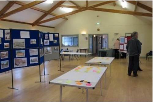
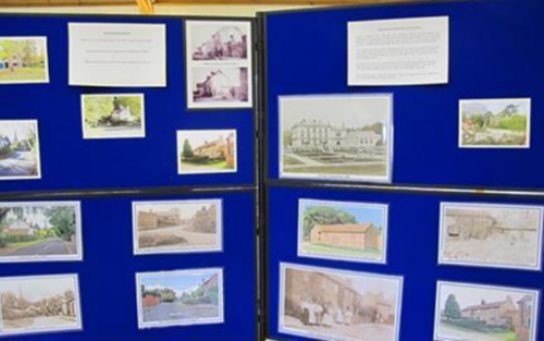
Village Hall Layout for Launch EventDisplay Board
A series of 5 display boards and two large-scale village maps were set out in the hall (see above), each focussing on a topic relating to planning and development.
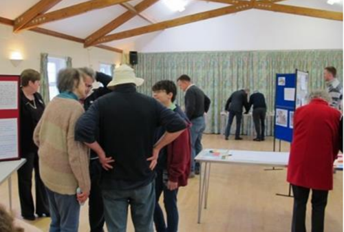
Comments and FeedbackLaunch Event Attendees
The turnout was impressive, with 68 attendees (village population 220) from 39 of the 99 properties in the village, providing important input into the future development of the plan.
In total 864 comments were received. A summary of the responses was distributed to every household.
Theme groups were appointed to gather evidence and formulate draft policy ideas, and these groups and the Working Group met regularly reporting back to the Parish Council.
An open invitation was sent to all businesses in the Parish to attend a meeting in the Village Hall on 17 October 2017.
The theme groups also used output from the March 2017 consultation, plus information gathered from businesses, to develop a detailed questionnaire which was distributed to every household in November 2017. Responses were received from 64% of households and provided very clear direction for the Plan and the future of the Parish.
A summary of the analysis was circulated to every household and an open event was held in the Village Hall on 3 February 2018, at which Parishioners could view all of the analysis and discuss issues. The full analysis was publicised on the Parish Web site.
On 21 May 2018 an open event was held in the Village Hall to allow Parishioners to view draft policy statements and make their comments which contribute to the plan. A total of 51 people attended this session plus a representative from Rushcliffe Borough Council. A wide range of comments was made which have been taken into account when finalising the Neighbourhood Plan.
There was overwhelming support for the draft policies amongst those who attended.
Throughout the process, people were kept informed by the regular monthly email briefing issued by the Parish Clerk, and these were supplemented at key points by leaflet delivery to every household.
5. Our Parish
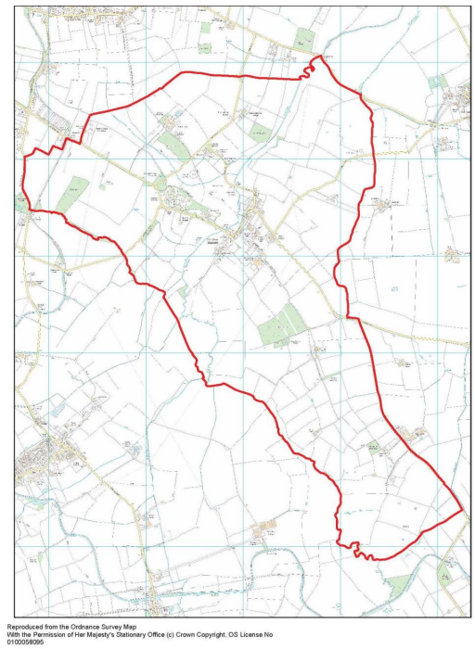
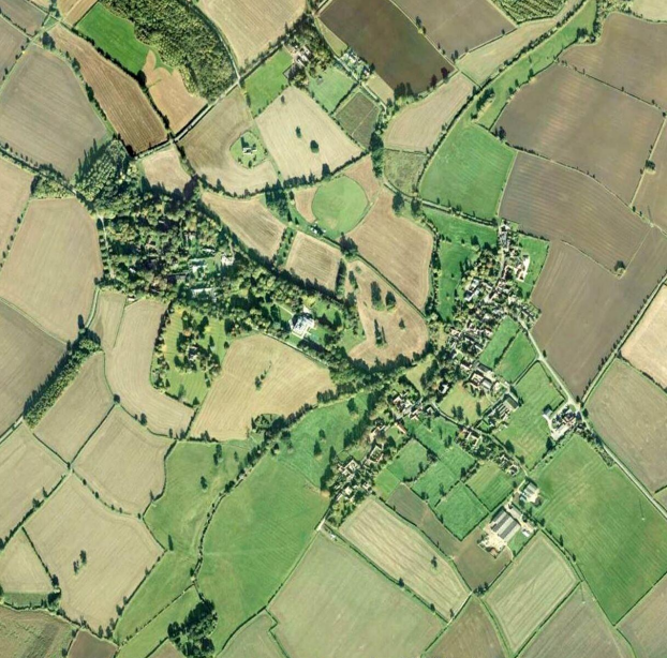
The Plan area comprises the whole of the Parish of Colston Bassett, within the Borough of Rushcliffe, as shown in figure 1. High resolution versions of all figures are available in the supporting information.
The area was formally designated by Rushcliffe Borough Council on 15 November 2016.
5.1 History of Colston Bassett
Colston Bassett is a small village with a wealth of history. Evidence in the form of Roman, Saxon, Viking coinage and pottery has been found in the surrounding fields. The landscape, in and around Colston Bassett, shows evidence of former ridge and furrow fields, deep ditches/dikes and dumbles; all remnants of a long established rural, farming community.
Before the Norman Conquest, there appear to have been two manors, perhaps divided by the River Smite. The origins of the name possibly coming from a Saxon chief named ‘Col’ and ‘ton’ a settlement. The word ‘smita’ means ‘a foul, miry place’, so the River Smite seems to mean a dirty, miry or muddy stream.
Morcaw, the powerful Saxon Earl of Northumberland, held the Manor of Colston. After the Battle of Hastings, Morcaw and his family initially acknowledged William as king and were left undisturbed, holding great swathes of land across England. After taking part in the Insurrection of 1068, his lands were forfeited and the Manor of Colston given to Thirstine the Norman, William’s Chief Falconer. Colston became an estate village from then, until the present time.
Records show that St Mary’s Church was built in 1115 and is the oldest structure in the village, although, according to the Domesday Survey of 1086, the village already had a church and a priest.
Ralph, son of Thirstine, succeeded his father around 1120 (during the reign of King Henry) and seems to be the first to take the name Basset. There followed a dynasty of eight Lord Bassets, all absentee landlords and the village became known by the family name - Colston Basset
In 1604 Colston Bassett suffered from a ‘severe visitation’ of the plague. All communication was cut off from the surrounding villages. The Plague Stone, where monies and necessities were left, is thought to be situated on the corner of Owthorpe Lane, buried by turf.
There is no substantiation in the legend that after the plague the village removed to its present position from the area around St Mary’s Church. The results of a geophysical survey carried out in the area in 2009 and 2010 showed no evidence of buildings or fire pits from a former village.
A copy of an Elizabethan map further indicates the absence of a village around St Mary’s Church in 1600. The village shown in its present location has changed little over the years. The Estate map of 1877 clearly shows the arrangement of the village, the River Smite, ponds, named woods, trees, established hedges, original field names and numbers.
In 1913, Colston Bassett & District Dairy was built and started trading a year later, specialising in the production of Stilton cheese. The Dairy celebrated 100 years of trading in 2013 and is the largest employer in the village.
The Estate has been owned by the Le Marchant family since 1877, and as a consequence, building development has been relatively limited in Colston Bassett, helping to preserve its historic character and wooded, rural landscape.
During the last fifty years Colston Bassett has changed from being a predominantly farming village, to a broader community of farming, commuters and small businesses run from home.
The village was designated a Conservation Area in 1976.
5.2 Colston Bassett today
Colston Bassett is a small rural Conservation village (population 220), substantially untouched by large-scale development due to good stewardship and management by the Estate over many years.
The village is in particular characterised by the many small open paddocks which afford open views to key features such as the Hall, St Mary’s Church, and St John’s Church (all listed buildings). The rural location, with green fields, trees, and beautiful views across the countryside are highly valued by residents. Access to pleasant walks, open green spaces, and living in an ‘unspoilt’ village are key features which make Colston Bassett an excellent place to live. The built environment has to date not been affected by significant large-scale developments, which would detract from the village ambience. A good community spirit, providing welcoming and open access to village social events, church activities, and creating a positive atmosphere for family life, is a key characteristic. The Village Hall and the Martin’s Arms pub provide well-supported community assets at the heart of the village, although in recent times the village has lost the valuable facilities of a shop, a state primary school, a post office, and a café.
Village demographics have undergone significant change over the last 50 years, from a predominantly farming community to one made up primarily of people from a professional background. The main employers are Colston Bassett Dairy (makers of award-winning Colston Bassett Stilton), The Martin’s Arms (award-winning dining pub), the (independent) Colston Bassett Primary School, plus farms and associated diverse farm businesses. A higher than average number of residents work from home or run businesses from home.
The average entry point for a three-bedroomed house in Colston Bassett (in excess of £360,000) combined with the current high proportion of large 4/5-bedroom homes, results in limited housing opportunities for young families and the elderly. Community consultation has confirmed that many residents share this view. Additionally, the tenure of housing in Colston Bassett is not typical of the Borough as a whole. Over 25% of properties are private rental, consisting in the main of cottages owned by the Estate. There is a widely-held opinion that a modest increase in smaller family homes for home ownership is desirable, linked to a clear wish to widen the diversity and age profile of the village.
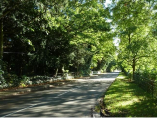
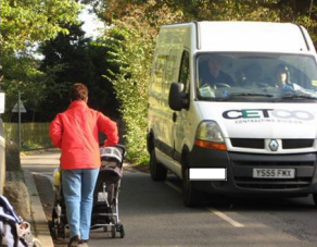
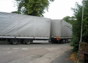
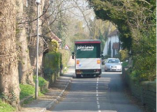
Two of the three approach roads into the village cross listed narrow single-track bridges over the River Smite, and roads are narrow lanes typical of a bygone age. A number of transport issues are a cause of considerable concern for many residents: peak flow through the village is growing and characterised by commuting traffic including to and from neighbouring villages (Harby, Hose, Cropwell Bishop, Cotgrave), along with undesirable HGV traffic, which is small in volume but has considerable impact due to the narrow nature of the village roads. On street parking in the Village centre and along Church Gate which is not only dangerous but also causes difficulties for farm traffic. A very poor bus service makes day to day life for those without a car extremely difficult.
6. Meeting the requirement for sustainable development
The NPPF states that there are three dimensions to sustainable development: social, environmental and economic, all of which are important and interrelated.
Social
We have sought, through the Neighbourhood Plan, to safeguard existing open space for the future enjoyment of residents.
We are also seeking to protect existing community facilities and to deliver a mix of housing types so that we can meet the needs of present and future generations and ensure that we support the community’s needs and its health, social and cultural wellbeing.
Environmental
In order to protect and enhance our natural, built and historic environment, we are seeking to ensure that housing development is of the right type in the right location, so that it does not harm but instead positively reflects the existing historic character of the area in order to:
Protect the village identity and conserve the rural nature of its surroundings;
Recognise the need to protect and, where possible, improve biodiversity and important habitats; and
Provide for improved pedestrian facilities.
Economic
Whilst the built-up parts of the parish of Colston Bassett are primarily residential, there is a small commercial element within the parish and a desire to ensure that appropriate economic activity is maintained as long as the local infrastructure supports it. We therefore wish to encourage employment opportunities in our area by:
Supporting appropriate existing business development and expansion where the local infrastructure would not be adversely affected by the proposals; and
Encourage start-up businesses and home working.
This document sets out local considerations for delivering sustainable development across Colston Bassett Parish. Development proposals should meet the requirements of all relevant policies in the Local Development Plan.
7. Neighbourhood Plan policies
7.1 The Strategic Framework
7.1.1 Introduction
The Colston Bassett Neighbourhood Plan is a key part of securing sustainable development as described in Section 1. The NPPF states that all plans should be based on and reflect the presumption of sustainable development and that neighbourhoods should plan positively to support local development.
When considering development proposals, the Plan takes a positive approach that reflects the presumption in favour of sustainable development.
Through the process of developing a Neighbourhood Plan, consideration has been given to the type and extent of new development required to meet the needs of the local community, where it should be located in the Parish, and how it should be designed.
As the Publication Rushcliffe Local Plan (Part 2: May 2018) states ‘Rushcliffe’s housing target [is] a minimum of 13,150 new homes between 2011 and 2028’.
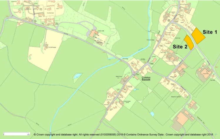
Rushcliffe Core Strategy Spatial strategy 3 describes the spatial strategy as being to support rural housing which contributes to affordable housing where there is a need to protect existing services. Spatial Strategy Policy 3 establishes a hierarchy of settlements across Rushcliffe. It identifies Colston Bassett as an ‘other settlement,’ below Key Settlements, where development should be restricted to infill development, small scale allocations or exception sites. In accordance with the Core Strategy (Part 1 and Part 2), the Neighbourhood Plan establishes the village boundary, within which infill development is in principle acceptable, and allocates two small housing sites.
The Local Plan (Part 2) describes Colston Bassett as amongst “the least sustainable locations for growth and covered by the housing in the countryside policy”. “New housing will be limited to small sites to meet a locally identified need (either through a housing needs survey or Neighbourhood Plan), housing to meet the needs of a rural worker, isolated homes in the countryside in accordance with NPPF paragraph 55, and replacement dwellings”.
Through the Neighbourhood Plan, the opportunity has been taken to positively plan for development within Colston Bassett that meets a local need and helps to support local services. The Limits to Development (see below) have therefore been extended in order to accommodate the potential for housing growth to meet a local need and to support the existing services up to 2028. An additional benefit has been to direct residential development to the most suitable locations.
The allocation of two small scale residential sites will enable the Parish to secure the growth that is recognised as being necessary through small-scale developments in locations that are favoured by the community, reducing the uncertainty that comes with speculative development proposals that threaten the character of the village. After community consultation, there was a clear preference to keep the special nature of the village intact for future generations to enjoy, therefore any new sites and density of development will be kept proportional to the size and character of the Parish. A substantial community questionnaire was undertaken in December 2017 to specifically address the issue of the location and extent of new housing in the Parish.
The Neighbourhood Plan supports two small residential sites and small-scale residential windfall development whilst also supporting limited business and commercial development that does not adversely impact on residential amenity. The Neighbourhood Plan also states how new housing should be designed, the housing mix required, as well as the improvements to the infrastructure that are needed to meet the requirements of the intended new development. In addition, by setting out a number of clear Community Actions, the Plan identifies on-going improvements in support of the land use proposals that will ensure delivery of the aims and objectives of the Neighbourhood Plan.
The Neighbourhood Plan is not intended to replace the policies contained in the Rushcliffe Local Plan or the requirements of the NPPF. It works in conjunction with these requirements to give additional, more detailed, Parish-wide specific policies that help to clarify and achieve the Community’s vision. Where suitable District-wide policies already exist in the Rushcliffe Core Strategy, emerging Local Plan or NPPF they are not duplicated in this Neighbourhood Plan.
In considering development proposals, the Neighbourhood Plan takes a positive and supportive approach with a presumption in favour of the sustainable development contained in the NPPF and Rushcliffe Core Strategy and Local Plan Part 2.
Where there are no specific policies in this Neighbourhood Plan which are relevant to a planning application or a development proposal, the full provisions of relevant National and District-wide planning policies will apply.
7.1.2 Settlement Boundary
Within Rushcliffe, all the ‘other villages’ (Non-Key Settlements) beyond the Green Belt do not have defined settlement boundaries, within which certain developments are, in principle, acceptable. Beyond these boundaries, in the open countryside, residential development is restricted in line with local and national strategic planning requirements’ The downside of such a policy can be that it overly restricts the necessary residential growth required to meet local needs and leads to an increase in house prices, making the Parish even more unaffordable to many.
The purpose of the new Neighbourhood Plan Settlement Boundary policy is to ensure that sufficient land to meet residential and commercial need is available in the right locations. The identified land uses will be supported by the current and proposed transport links and services infrastructure and will therefore be able to avoid encroaching into the local open countryside.
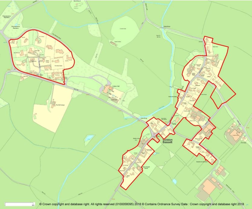
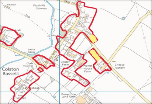
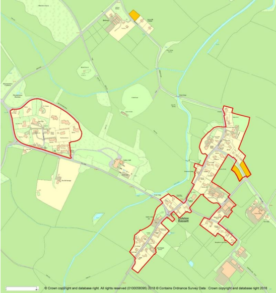
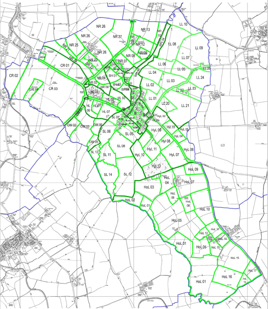
The Neighbourhood Plan has therefore designated a Settlement Boundary policy for the built form of Colston Bassett – as shown below in figure 2. The Settlement Boundary takes into account the housing allocations proposed through the Neighbourhood Plan.
Two distinct Settlement Boundaries are shown. The first contains the original village centre with the Market Cross at its heart. The Village Hall, its two paddocks flanking either side, and The Martin’s arms Public House are the hub of Village activities. Properties in this part of the village are a mixture of Georgian and Victorian houses, brick and pantile cottages and barns, along with some more modern properties developed on infill or back-land sites. The second Settlement Boundary consists of the Colston Hall Grounds area which was developed in the mid 1960’s. Narrow driveways lead to a variety of modern detached properties. In addition there are mews houses, in the design of the listed Hall, which were converted from the Hall’s former stables.
Within each defined Settlement Boundary an appropriate amount of suitably designed types of development in the right location is acceptable in principle, although some sites within the Settlement Boundary are protected from development and all development will be required to take into account the policies within this Neighbourhood Plan.
To re-iterate, focusing development within the agreed Settlement Boundary will support existing services within the village and protect the open countryside setting of Colston Bassett from inappropriate development.
7.1.3 The Methodology used
The community have expressed a clear desire to protect what is special about Colston Bassett for future generations. Its countryside setting, and the quiet pace of rural life are seen as being of particular importance.
In designating the Settlement Boundary, the Colston Bassett Neighbourhood Plan has applied the following methodology:
Defined physical features such as walls, fences, hedgerows, gardens, allotments, streams, formal leisure uses and roads have been used to delineate the boundary;
Non - residential land which is countryside, agricultural land, paddock, meadow, woodland and/or other green-field land has been specifically excluded;
The small residential sites allocated within the Neighbourhood Plan have been included within the Settlement Boundary;
Any development will only be encouraged where the site is wholly within the Settlement Boundary.
In statutory planning terms, land outside a defined Settlement Boundary, including any individual or small groups of buildings and/or small settlements, is treated as open countryside.
It is national and local planning policy that development in the countryside should be carefully controlled. It should only be allowed where it is appropriate to a rural location, such as for the purposes of agriculture, or where it requires a rural location, for recreation, sport or leisure. In addition affordable housing developments may be acceptable beyond the settlement boundary (where open market housing is restricted) as exception sites.
This approach to development in the open countryside is supported by this Neighbourhood Plan, in particular, because it will ensure that any development is focused in the built-up form of Colston Bassett which only has a very limited range of services and facilities.
The following policy (S1) will also help to maintain the special and unique landscape character and setting of Colston Bassett and protect the open countryside for what it is, an attractive, accessible, distinct and non-renewable natural resource.
The settlement boundary defines where Rushcliffe Borough Council Policies 11 (Housing developments on unallocated sites within settlements) and 22 (Development in the Countryside) of Local Plan Part 2 will be applied alongside policy S1. Small scale infill in the context of RBC policy 11 and development in ‘other villages’ will only apply to developments within the settlement boundary.
POLICY S1: SETTLEMENT BOUNDARY - Development proposals within the Neighbourhood Plan area will be supported on the sites within the Settlement Boundary as shown in Figure 2 (above) where the proposal complies with the policies in this Neighbourhood Plan including the need to achieve positive design and amenity standards.
Land outside the defined Settlement Boundary will be treated as open countryside, where development will be carefully controlled in line with local and national strategic planning policies.
7.2 Housing and the Built Environment
7.2.1 Introduction
The core aim of this Neighbourhood Plan is to retain the integrity of Colston Bassett as a small and vibrant rural village. Colston Bassett has been designated a Conservation Area since 1975 with 7 listed buildings and limited community facilities. The Centre of the settlement lies to the West of the River Smite and is concentrated on School Lane and Church Gate. The village is characterised by predominantly cottage style housing with various undeveloped paddocks and gardens giving green open views in and out of the village along Church Gate, School Lane, Bakers Lane, Bunnison Lane and Hall Lane. The aim is to retain this compact, characterful village and to restrict future housing to within the Settlement Boundary.
Under the present Rushcliffe Borough Core Strategy Colston Bassett is classified as an ‘other village’ where development is carefully controlled in order to deliver a sustainable distribution of development and protect the integrity of the landscape, character and settlement pattern. Our aim is to continue to protect the integrity of the village of Colston Bassett for present and future generations.
The demographics of Colston Bassett have undergone significant change over the last 50 years. After the Second World War, it was predominantly a farming community with as many as six farms all with the principal housing and farm buildings within the village boundary. Alongside this principal form of employment was the cooperative cheese making dairy opened in 1913 and still producing nationally award-winning stilton cheese. Over the last 50 years some of the farms have ceased to operate and in many cases the land and buildings have been converted into residential development. As the principal agricultural employment has declined and the buildings replaced with three and four-bedroom houses, the population has changed from a predominantly manual class of workers to one which is now mainly people from a professional background.
The average entry point in Colston Bassett for a three-bedroomed house is in excess of £360,000. The community consultation has shown a demand for smaller and more affordable housing to be provided in the Parish. Through the Neighbourhood Plan the opportunity has therefore been taken to plan positively for housing delivery that meets a local need by allocating sites to help support local services and by supporting affordable housing, particularly home ownership models.
The allocation of the sites shown below under policy H1 will enable the Parish to secure the growth necessary up to 2028 to help to sustain the local community and its limited services, as well as contributing to the District’s housing target through locations that are favoured by the community.
7.2.2 Housing Allocations
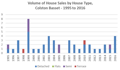
An assessment of the limited options for residential development in the Parish was undertaken by the members of the Housing Theme Group (See Appendix 1). Two sites are put forward in this Neighbourhood Plan as allocations for 10 units. The Colston Bassett Settlement Boundary has therefore been relaxed in order to include these sites – development sites (as shown below in figure 3) as appropriate sites to contribute towards the housing growth required to 2028.
A strong theme from the statistical data and the local consultation activity has been to address the difficulty of young people, or less well-off older people to be able to afford to live in the Parish. The ridge height of dwellings has been restricted to a maximum of one and a half storeys to maintain the aesthetic appearance of the entrance to the village.
Residents expressed a strong preference that a small number of new homes (a range of 0-10 favoured by 68% of respondents to the questionnaire) of modest (2 / 3 bedroom favoured by 78%) lower cost housing be developed for home ownership (freehold properties supported by 86% of respondents). The expressed desire for home ownership is closely linked to the fact that there is currently a high proportion of houses for rent within the Parish (25%) considerably higher that the Borough average (12%).
Advice from Environmental Health highlights that sites 1 and 2 have historically been used for agricultural purposes and it is likely that the land may be contaminated. With this in mind, a site investigation should be carried out as a requirement of any associated planning consent.
As a consequence of the Strategic Environmental Assessment Screening Report undertaken by Rushcliffe Borough Council, a Heritage Assets Assessment was prepared which identified the potential for archaeological remains on site 2. A desktop research exercise and, if necessary, field evaluations should be undertaken at the planning application stage.
POLICY H1: RESIDENTIAL SITE ALLOCATIONS - Land is allocated for residential development at the locations shown above at figure 3 and within the new Settlement Boundary (figure 2). Development will be supported at these locations subject to the following conditions:
Site 1 – Development will be supported / provided:
It is for up to 6 dwellings;
The dwellings to be no larger than 3 bedrooms and of a ridge height no higher than the existing neighbouring properties and to be of no more than one or one and half storeys;
The public footpath be continued along the north side of Harby Lane to serve the development;
The housing provides a mixture of 2 and 3 bedroom dwellings including home ownership models of affordable housing.
Site 2 – Development will be supported / provided:
It is for up to four dwellings which should be single or one and a half storey and constructed to meet the needs of older people
The housing provides for a mix of 2 and 3 bedroom dwellings including home ownership models of affordable housing.
7.2.3 Windfall Development
A windfall site is defined in the NPPF as one which has not been specifically identified in the development plan.
To help protect the village character, development beyond the housing allocation described in H1 above will be restricted to windfall sites wholly within the Settlement Boundary and will be of no greater size than two new properties on any single site.
To meet the need for smaller dwellings, single unit developments will be of a suitable scale to the site but developments of two units will include at least one dwelling that is no more than three bedrooms in size.
The mix of housing proposed within the Neighbourhood Plan is based on the available statistical data and the views of residents obtained through various consultation exercises including open events and a community questionnaire.
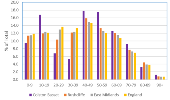
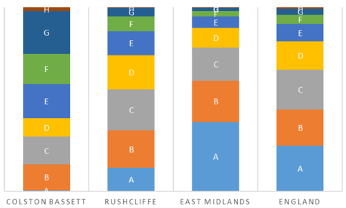
Colston Bassett is a very small parish and at the time of the 2011 Census was home to 220 residents living in 104 households. Analysis of the Census shows that the majority (55%) of residential dwellings are detached which is higher than average for the district and for the region generally (32%). There is evidence that the population is ageing and in line with national trends the local population is likely to live longer and require “old persons friendly” housing provision as average life expectancy continues to rise.
More than 45% of households live in houses with four bedrooms or more, which is higher than the district (33%) and the regional figure of 20%. Around 55% of all occupied households have two or more spare bedrooms and around 32% have one spare bedroom. Under-occupancy is higher than the district, regional (20%) and England (19%),
The specific housing mix required in the allocated sites is stipulated in policy H1.
Policy H2 recognises that further windfall sites may come forward during the Plan period and specifies the housing requirements beyond the residential allocations provided in Policy H1. Further evidence of housing need is provided in the housing needs report (2016) as set out in Appendix 2.
POLICY H2: WINDFALL SITES - Development proposals for infill and redevelopment sites of less than three dwellings will be supported where:
The location is within the Settlement Boundary for Colston Bassett;
It retains existing important natural boundaries such as gardens, trees, hedges and streams;
It provides for a safe vehicular and pedestrian access to the site;
It does not reduce garden space to an extent where it adversely impacts on the character of the area, or the amenity of neighbours and the occupiers of the dwelling(s).
The development provides a mixture of housing types specifically to meet identified local needs in Colston Bassett as evidenced in the Parish Housing Needs Report (2016) or any more recent document updating this report. Dwellings of 3 bedrooms or fewer and single storey accommodation suitable for older people will be supported where in accordance with other policies. Any two-unit development should include at least one dwelling of 3 bedrooms or fewer.
7.2.4 Tandem Development
Consultation has highlighted a lack of support for ‘tandem’ and ‘back land development’ defined as the placing of one dwelling behind another within a single plot and the erection of a dwelling or dwellings on parts of large gardens attached to existing dwellings.
POLICY H3: TANDEM AND BACK LAND DEVELOPMENT - in gardens of existing properties, tandem and back land development will be supported unless it causes harm to residential amenity or harm to the local area. Harm includes where this development reduces existing garden space to such an extent it adversely impacts on the character of the area or provides inadequate levels of private residential amenity of neighbouring and proposed dwelling(s).
7.2.6 Design Standards
It is the view of the Colston Bassett community that the Neighbourhood Plan will ensure that any future development either reflects the village’s architectural character and fully integrates into the village environment or makes a positive high-level architectural contribution to the specific location.
There should be an expectation of high-quality materials and sustainability in any future house building in order to sympathetically integrate with the character and environment of Colston Bassett. The proposed location of any development should not adversely influence any of the Local Green Spaces within the village that make a strong contribution to the overall character and physical form of the Parish.
Design guidance for future development includes:
New dwellings to be set back from front boundaries,
Plots to end clear of lane junctions,
Facing brick to external elevations with no concrete blocks,
Decorative brick stringing and corbel courses to be encouraged,
Roofs to be finished in clay pantiles or slate; other roofing materials to be discouraged,
Windows of timber construction preferred; the use of metal/anodized aluminium discouraged,
New properties should be limited to no more than two stories in height and compatible with surrounding properties.
POLICY D1: DESIGN - Development proposals including one or more houses, replacement dwellings and extensions should have regard to the following building design principles to a degree that is proportionate to the development.
Development will be required to preserve or enhance the local distinctiveness and character of the area in which it is situated, particularly within the Conservation Area, and proposals should clearly show within a Design and Access Statement, where one is required to be submitted, how the general character, scale, mass, density and layout of the site, of the building or extension fits in with the aspect of the surrounding area. In addition:
Care should be taken to ensure that the development does not disrupt the visual amenities of the street scene and impact adversely on any wider landscape views;
Where appropriate at least two off-street car parking spaces should be provided within the curtilage for each new dwelling. Three such spaces should be provided for four-bedroom or larger dwellings;
All new housing should continue to reflect the character and historic context of existing developments within the Parish and incorporate a range of local materials where possible. However, contemporary and innovative materials and design will be supported where positive improvement can be robustly demonstrated without detracting from the historic context;
Development should be enhanced by fostering biodiversity and providing landscaping with existing trees, elevations and hedges preserved whenever possible;
Wherever possible, enclosure of plots should be of native hedging, rural wooden fencing, or brick/stone wall of rural design;
Development should incorporate sustainable design and construction techniques to meet high standards for energy and water efficiency, including the use of renewable and low carbon energy technology, solar panels, rainwater harvesters and photovoltaic glass. These features should not adversely detract from the visual amenity of the current street scene;
Development should incorporate sustainable drainage systems with maintenance regimes to minimise vulnerability to flooding and climate change; ensuring appropriate provision for the storage of waste and recyclable materials.
7.3 Natural and Historical Environment
The natural and historical environment is acknowledged to be an essential component of sustainable development; as such it carries significant weight in a balance against social and economic growth, including new development. This section identifies land and features of environmental significance in Colston Bassett. It includes policies to protect the best of these from loss or damage by allocating them to categories, based on their type, importance, function (as community assets, for example) and intrinsic value.
7.3.1 Introduction
The Parish of Colston Bassett sits on the western end of the Vale of Belvoir in gently undulating countryside close to the Belvoir escarpment, which rises to the south and west. It is bisected by the River Smite which starts on the edge of the escarpment and runs in a north east direction towards the River Trent.
7.3.2 Environmental designations
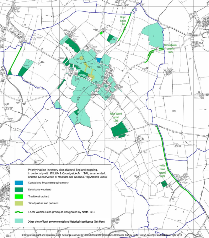
The Neighbourhood Plan area is part of the Trent and Belvoir Vales National Character Area (NCA 48, designated by Natural England). There are over 20 sites of local and national historical significance (Scheduled Monuments, Listed Buildings). For biodiversity, there are 4 designated Local Wildlife Sites (LWS) and a number of Priority Habitats (designated by Natural England) including Deciduous Woodlands, Wood pasture and Parkland, Traditional Orchards and Grazing Marsh.
7.3.3 Geological setting
The gently undulating and low-lying landform of the Parish is largely a result of its geological history and structure.
The underlying bedrock is represented by Triassic and Jurassic mudstones and limestones, dating back 200 million years, with bands running in a predominately north east to south west direction This has given rise to base-rich loamy and clayey soils across much of the area, coupled with silt, sand and gravel deposits, The Jurassic Lias Group includes thin beds of harder rocks such as marlstone which has slowed the weathering of underlying mudstones most clearly seen in the Jurassic Marlstone-capped Belvoir escarpment to the south and west.
Underlying these Triassic and Jurassic rocks are found the Carboniferous mudstones, siltstones and coal seams of the Nottinghamshire coal field.
During the Quaternary period (less than 1 million years ago) the whole area was covered by ice sheets. The Vale was occupied by a large mass of ‘stagnant’ ice. While surrounding areas were being smothered with glacial deposits, the Vale was protected so that Jurassic ‘bedrock’ can be seen close to the surface.
The River Smite flows north east from this escarpment through the centre of the village fed by a number of stream tributaries. The borders of the Smite and these streams are marked by more recent alluvial deposits. The streams, locally known as dumbles and becks, have cut deep narrow ditches in the landscape.
7.3.4 Natural environment
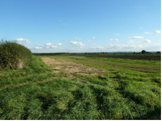
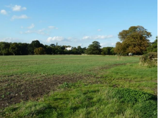
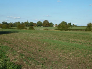
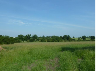
The landscape has a strong rural character, with wide areas retaining a sense of tranquillity and self-containment. The undulating landscape affords a range of open views both into and out of the village, and across open fields towards the surrounding escarpment.
The River Smite and its tributaries provides a strong feature running through the landscape and is the greatest biodiversity resource, being a major corridor for wildlife moving through the area and largely fringed by ancient hedges and trees. The disused Grantham Canal which borders the Parish to the west is another key green infrastructure link in the area. A range of natural ponds allowed by the clay lands are another significant water feature.
The Vale of Belvoir in general has typically low levels of woodland cover. The Parish stands out as an area where old deciduous and mixed woodlands have been preserved, particularly in proximity to the village centre, and this is a strong characteristic of the Parish.
A regular pattern of medium to large fields enclosed by hedgerows, dominates the landscape. This is one of the areas of England most profoundly affected by the early enclosure of open fields and remaining blocks of common land in the late 17th and 18th centuries. Many of the hedgerows seen today date from this period.
The area’s generally fertile clay soils and good quality agricultural land have supported a diversity of farming over a long period but, because of this, little semi-natural habitat remains. Traditionally a mixed farming area, its intrinsic landscape character has been weakened by modern agricultural practices and development. Pasture and ponds have been lost and more intensive agricultural land use means that biodiversity has been diminished.
Remnant ridge and furrow reflect the various stages at which cultivation succumbed to pasture from the later medieval period to late 18th Century. Evidence of these pastures still exists, primarily within the centre and borders of the village which have been less susceptible to more intensive agriculture practices.
The surviving pastureland, woodlands and wildlife sites are therefore of high natural environmental importance to the Parish.
7.3.5Environmental inventory
An environmental inventory (covering the entirety of the Plan area) of Colston Bassett was carried out between February and October 2017. (See Appendix 3). The aim of the inventory is to provide some form of objective assessment for identifying sites of environmental significance for the purposes of the Neighbourhood Plan. The work comprised two elements:
Review of all existing designations and available information, and
Fieldwork to identify sites and features of natural and historical environment significance in the context of the Plan Area.
The review compiled information from many sources, including:
DEFRA
Natural England
Historic England
Nottinghamshire and Rushcliffe Records
Environment Agency
British Geological Survey
Old maps (Ordnance Survey, manuscript)
Local history and archaeology publications
Local knowledge
Local consultation.
The fieldwork reviewed all open and currently undeveloped land in the Plan Area, and significant species, habitats, landscape characteristics, earthworks and other extant features were checked.
The data, along with all relevant site-specific information from the existing information review, were mapped and tabulated, and each site was scored and evaluated using the nine criteria for Local Green Space selection in the National Planning Policy Framework 2012.
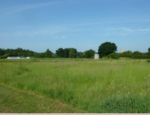
7.3.6 Local Green Spaces
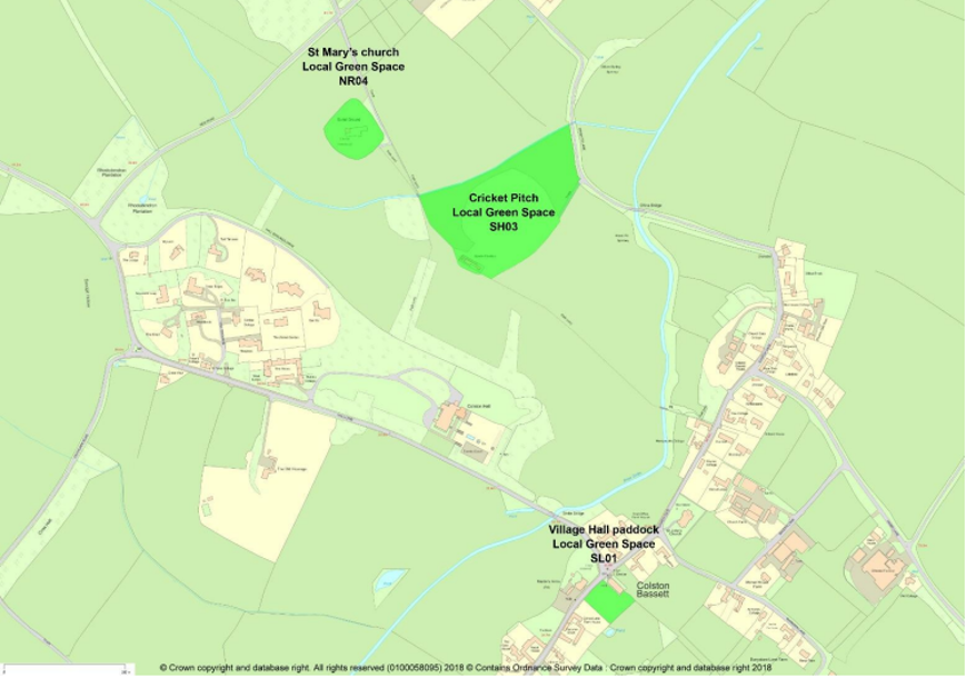
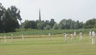
Three areas scoring 75% (25/32) or more are designated as Local Green Spaces (see Appendix 3), comprising a paddock adjacent to the village hall and areas round St Mary’s Church and the Cricket Ground. Their statutory protection will ensure that these most important places in the Plan area’s natural and human environment are protected. The paddock next to the hall was an old orchard and is now an important village amenity when used in conjunction with events in the village hall. The areas around St Mary’s Church and the Cricket Ground are areas of historical significance and of high importance to community amenity; both are well-served by regularly used footpaths providing good access.
Further information relating to the importance of these areas can be seen in Section D - Community facilities.
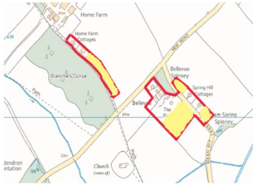
POLICY ENV 1: LOCAL GREEN SPACES – The sites designated as Local Green Spaces are shown above (figure 4) and listed below:
the paddock to the right of the Village Hall (Ref SL01);
the area around St Mary’s Church (NR04); and
the Cricket Pitch and surrounding area (SH03).
Development will only be permitted in these areas in very special circumstances and must not undermine their visual or social importance.
7.3.7 Other sites of environmental and historical significance
A second group of inventory sites are all significant at the neighbourhood level for ‘wildlife’ and/or ‘history’ but, because their community value and accessibility scores are not high enough they are not eligible for Local Green Space designation. The sites included within this category are:
Those recorded as Priority Habitats by Natural England,
Confirmed Local Wildlife Sites (LWS),
Sites identified as being of high biodiversity significance in the context of the Plan Area, in particular grazing paddocks within the village centre
Parcels of land of known local historical significance
Together, these sites are essential for biodiversity conservation in the Parish.
Other environmental topics – trees and woodland and biodiversity and wildlife corridors are identified and dealt with in subject-specific polices elsewhere in the Plan, although it should be noted that occurrence of such biodiversity and historical features on the sites protected here by Policy ENV 2 has been taken into account when evaluating and selecting them for inclusion.
POLICY ENV 2: PROTECTION OF OTHER SITES AND FEATURES OF ENVIRONMENTAL AND HISTORICAL SIGNIFICANCE - The sites identified on the map (figure 5, below) and listed in the environmental inventory (Appendix 3) are identified as sites of important environmental or historic value. Where development is considered acceptable in principle, having regard to other relevant policies in this Plan, it will be supported subject to the following requirements:
An appropriate assessment of environmental impacts has been carried out;
Trees and hedges are preserved wherever possible and replacements are provided on or close to the site for any trees or hedges that cannot be preserved;
Watercourses are protected from erosion and impacts that would lead to a reduction in water quality. Where practical watercourses should be included in any green infrastructure on the site.
7.3.8 Biodiversity and Wildlife Corridors
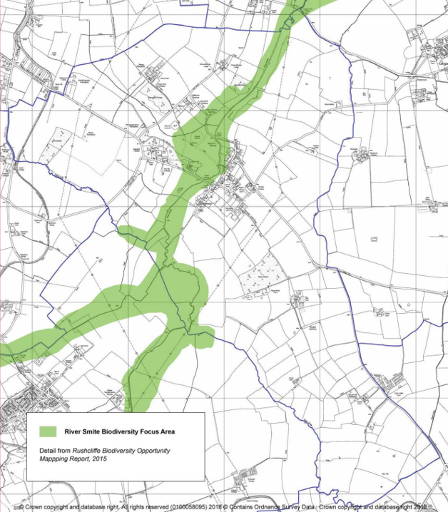
Colston Bassett has a number of priority habitats, primarily deciduous woodlands and wood pasture/parkland. There are also five locally designated wildlife sites. The ‘Rushcliffe Biodiversity Opportunity Mapping Report’ – C Jackson and N Crouch 2015, – published by Nottinghamshire Biodiversity Action Group, identified the Smite and its tributaries as a focal area of particular value (figure 6). The 1877 map of the Parish shows a network of fields and ancient hedgerows that still exist today which provide important wildlife corridors. These are complemented by a network of pastures within the village, many retaining traces of old ridge and furrow, which provide important areas of diversity within the wider arable landscape. Old ponds are scattered throughout the parish are important in supporting biodiversity. There are also a number of bat roosts which support a strong population of bats in the village and a variety of species. Older structures and ancient walls such as those at St Mary’s Church also provide important habitats.
The need for every community to make its own contribution to reversing the current threats to and loss of priority habitats and species is recognised through the consultation responses. Protection and encouragement of wildlife was regarded as important by 93% of respondents.
The parish therefore, is important for its biodiversity and opportunities exist to protect and enhance this network. Developments can assist by incorporating habitat enhancing features such as bird or bat boxes or appropriate native woodlands, planted tree and hedgerow boundaries, ponds, wetlands and meadows or other enhancing features. Biodiversity enhancement (species and habitats) is supported by the National Planning policy Framework and the UK Conservation of Species and Habitats Regulations, 2010, Amended 2012. The Policy and Community Action here provide for proactive measures: having up-to-date information about Parish wildlife; requiring developers to take biodiversity into account in their proposals; and mobilising the community to create new, and manage existing, habitats to enhance biodiversity.
POLICY ENV 3: BIODIVERSITY AND WILDLIFE CORRIDORS – locally significant and locally important habitats and species must be safeguarded, especially those protected by relevant English and European legislation.
New development in the Plan area must seek to promote biodiversity. Where appropriate and practicable, the following measures will be required:
any loss of habitat is mitigated by replacement habitat in locations that enhance the connectivity of habitats;
the design of new development includes new habitats for wildlife, and ensures that wildlife corridors are not severed;
any planting around new development will use native species;
development which is likely to significantly harm a local or nationally-important biodiversity asset will require an ecological assessment;
water-bodies are incorporated into any development as part of the green space to ensure that they can provide important drainage and biodiversity functions.
Community action Env 1: Biodiversity
The Parish Council will seek to engage with community groups, landowners, funders and other organisations to enhance the biodiversity of the Parish.
The Parish Council will seek to preserve and enhance local wildlife sites or potential wildlife sites, including protection of the River Smite corridor and its tributaries.
The Parish Council will encourage initiatives to record wildlife and identification of potential Local Wildlife Sites.
7.3.9 Trees, Woodland and Hedges
Trees have always been an important feature of Colston Bassett and woodlands are regarded as a key characteristic by Colston Bassett (see figure 7) and residents. In consultation 89% of responses considered trees and woodlands an important characteristic and it was ranked as the most important landscape feature with 93 % considering it important.
From 1800, new Estate owner, Henry Martin embarked on a massive programme of tree planting, a tradition continued by George Davy and then Robert Millington Knowles, when he purchased the Estate in 1877.
The village still remains heavily wooded and Colston Bassett currently has twelve Natural England Priority Habitat woodlands, some bearing historical testament to family members, who once owned the Estate: Kaye Wood, Winifred Wood, and Blanche’s Gorse. Many fields, lanes and roadsides contain copses and shelterbelts; there are numerous ancient hedges, some residual ancient, woodland trees and a number of large, rare specimen trees.
Recent years have seen a number of trees felled through development, harvesting or disease, including hedgerow trees, although there has a programme of tree planting in open areas. In the past the Parish Council has initiated community tree planting schemes, along Langar Lane, Harby Lane and Colston Road. More recently, volunteers planted trees along the Jubilee Walk.
Although it is encouraging to see English elm slowly regenerating in parts of the village, it is concerning that foreign pathogens are affecting other species such as horse chestnut and ash trees which present a risk to the current landscape.
This policy ensures that the landscape and ecological value of trees, woods and hedges in the parish is recognised in the Plan, through continuation of both the Tree Preservation Orders process and the protection afforded to trees and hedges within the village’s Conservation Area. It adds to these measures a requirement for developers to retain any significant trees on their land whilst encouraging proactive management of the wooded landscape and hedgerows to ensure necessary felling is matched by appropriate replacement planting.
POLICY ENV 4: IMPORTANT TREES AND WOODLAND - Development proposals that damage or result in the loss of trees, woodland and hedges of arboriculture/ecological significance and amenity value will be not generally be permitted unless there is a clear mitigation proposal close to the site.
Community action Env 2: trees and woodland. The Parish Council should explore the most effective way of maintaining a tree planting programme, exploiting available grants and working with local landowners. Encourage local participation in recording and monitoring trees.
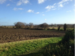
7.3.10 Important Views
Colston Bassett benefits from being situated in undulating countryside on the edge of the Belvoir escarpment and therefore enjoys good long-distance views across the Vale to the escarpment together with views into and within the village. Consultation during the Neighbourhood Plan’s preparation identified a broad range of valued views within the village and toward it from the surrounding countryside. In responses to the consultation questionnaire, 91% rated vistas and views across and around the village as important. Over 70% of respondents regularly use the footpaths around the village and the views are complementary to this important amenity.
The consultation indicated a wide range of views that were valued by the community and this should be taken into account when considering new developments. Views of particular significance are noted below (Figure 8).
Figure 8 - Important views
POLICY ENV 5: IMPORTANT VIEWS - New development should be designed to respect locally important and valued views (see figure 8 above) and where possible enhance those views.
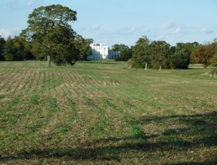
From St Mary’s Church across undulating countryside towards the old Roman road, the Fosse WayFrom St Mary’s Church east across the Vale of Belvoir toward Belvoir Castle, with Colston Bassett cricket ground in the foreground (behind the first hedgerow)From the end of School Lane south across open arable fields to the Belvoir escarpmentFrom the end of School Lane north towards Colston Bassett HallFrom Owthorpe Road footpath looking northeast along remnants of old avenue leading to Colston Bassett HallFrom Owthorpe Road footpath east across the river Smite to the end of School LaneFrom China Bridge (Listed) across cricket ground to St Mary’s Church, with Colston Bassett Hall grounds in the backgroundFrom end of Church Gate north towards Spring Hill across the tree-lined river Smite (at the bottom of the first field)Entrance view southeast into the village from Cotgrave along Hall Lane. Colston Bassett Hall entrance on left
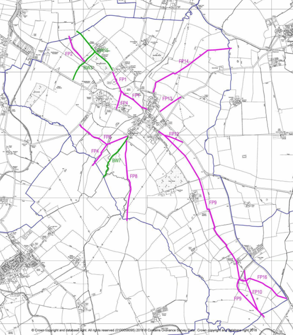
7.3.11 Rights of Way
Public footpaths and bridleways in England are mostly historic rights of way, remnants of the network of ‘ways’ established by use, over centuries, as people walked or rode to the fields, to neighbouring villages or to local markets. Colston Bassett has a relatively good network; they are well-used, 72% of respondents in the consultation use them at least weekly, and residents regard them as important for their recreational (as a contribution to physical and mental health and wellbeing) and for their socio-historical value. The village is also a popular meeting point for walkers from outside of the Parish and these provide important support for community assets such as the Martins Arms pub. The network of local footpaths is therefore an important local amenity (Figure 9).
POLICY ENV 6: FOOTPATHS AND BRIDLEWAYS - New development must protect the existing network of footpaths and bridleways.
Community action Env 3: Footpaths and Bridleways- The Parish Council will work with the Local Authority and local landowners to ensure footpaths and bridleways are properly maintained and marked.
Figure 9 - Footpaths
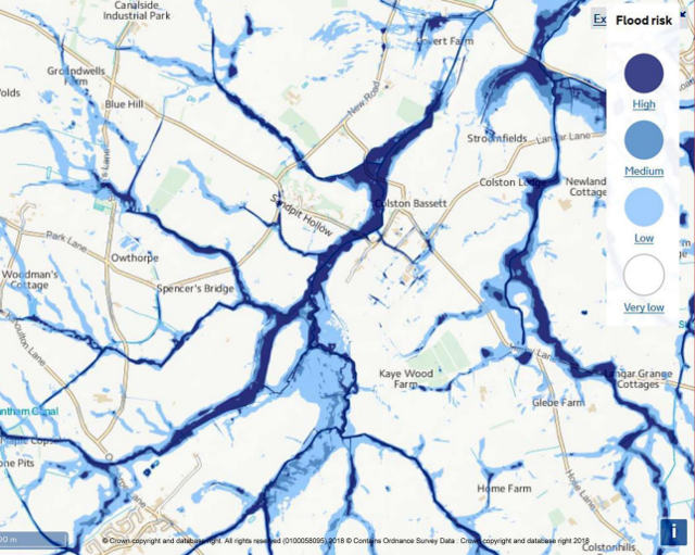
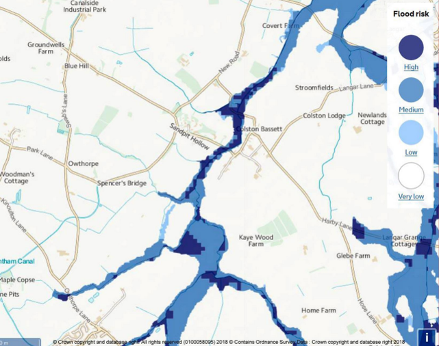
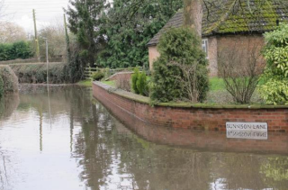
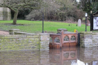
7.3.12 Managing Flood Risk
The parish is located close to the Belvoir escarpments and there are a number of natural watercourses that run off the escarpment and converge as tributaries of the River Smite throughout the Parish. The main River Smite runs through the village. Consequently, there are large areas prone to river and surface water flooding (figures 10 and 11). This rarely affects existing housing but there have been regular instances in recent history of the main roads being impassable due to standing floodwater (see photos below). More irregular climate patterns associated with Climate Change may increase this risk. The intention of this policy is to ensure that current best practice is applied in order new developments are not at risk of flooding and that the risk is not exacerbated further by new development.
Figure 10 – Surface water flooding (Environment Agency mapping)
Figure 11 – Flooding from rivers (Environment Agency mapping)
POLICY ENV 7: MANAGING FLOOD RISK - New development will be required to demonstrate that the site is safe from flooding and does not increase the risk of flooding to third parties, taking climate change projections into account.
Community Action Env 4: Managing Current Flood Risk - The Parish Council will work with the relevant Authorities to address the current flooding problems in the village, particularly the area in proximity to the junction of Church Gate and Bunnison Lane.
Bunnison Lane floodingChurch Gate flooding
7.3.13 Light Pollution
The Parish benefits from a rural location and relatively dark skies which are valued by the community with 84% of consultation responses rating dark skies and low light pollution as an important characteristic. The Campaign for Rural England mapped light pollution in the night skies in 2016 (http://www.nightblight.cpre.org.uk/) and the Parish generally falls into Category 3 with night light emission recorded in the range 0.5 to 1 compared with typical town centres in the range 16 to 32 and the darkest skies in the range below 0.25. Consultation responses indicated that 86% regarded positive steps to limit light pollution as important. This is consistent with the Conservation Area Plan which already states any external lighting should be carefully designed and sited to minimise light pollution and this is extended to the broader impact from new development.
Where there is concern that internal and/or external lighting would have a significant effect on the amenity of local residents, the darkness of the local area or nature conservation, the design of the development and lighting scheme should reduce these effects to acceptable levels. These design measures could entail, the orientation and layout of the property, and the reduction and/or use of special glazing.
POLICY ENV 8: LIGHT POLLUTION - Development must be designed to limit the impact on light pollution and light spillage from artificial externally visible light sources including security lights, through the use of motion sensors, timed lights and softer lighting.
Community Action Env 5: Light Pollution - For existing developments and housing, the Parish Council will encourage action that mitigates light pollution consistent with the policy for new developments.
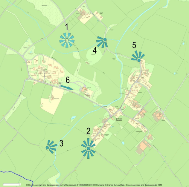
7.3.14 Renewable energy infrastructure
The contribution of renewable energy in combating Climate Change is recognised and there was support for projects that have a limited impact taking into account the importance attached to the open countryside and views.
POLICY ENV 9: RENEWABLE ENERGY INFRASTRUCTURE - Renewable energy developments will only be permitted where any adverse impact on the parish landscape and tranquillity can be mitigated.
7.4 Community Facilities
A wide range of community facilities, amenities and assets exists in Colston Bassett; these make a distinct and significant contribution to the vitality of the Parish. They have a positive impact on the sustainability and quality of life for residents and provide essential opportunities for social interaction, friendship and community support.
To guarantee the on-going prosperity of the Parish, it is essential that existing community facilities are retained, protected and strengthened to ensure they continue to sustain the vitality of the community.
The importance and high value attached to existing community facilities were highlighted in residents’ responses at both the Open Day event and the consultation questionnaire organised to assist preparation of this Neighbourhood Plan. The most important facilities, amenities and assets are briefly described here; more details on many of these may be found in the publication: “The Village of Colston Bassett – A Pictorial History”, Colston Bassett Local History Group, ISBN 978-0-9559629-0-5, 2008.
7.4.1 Current Community Facilities, Amenities and Assets
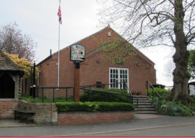
The Village Hall
The Village Hall is a meeting place for many village community events. It is the venue for meetings of the Parish Council and the Women’s Institute. Many clubs and societies use the Hall and its facilities as their base. Charity fund-raising, Village Fetes and Barbeques, private functions and parties, weddings, plus regular drama and musical events take place here. Forthcoming activities at the hall, contact details, and Parish Council meeting minutes are viewable on the exterior notice boards and on the Parish Council website. The present building dates from 1999, replacing a large wooden structure (ex-Army 1st World War hut) erected in 1920. The Village Hall committee (all volunteers) manage the running and maintenance of the building and its facilities. Continued and increasing support by residents, visitors and guests attending events are crucial to ensure the future of this core village asset.
Village Hall
84% of questionnaire respondents considered the Hall to be important/very important to the village.
Village Hall Paddocks
Closely linked to the Village Hall (and its ability to serve as a vital Parish asset) are paddocks located either side of the Hall building. Indeed it should be stressed that the ongoing successful contribution to Parish life made by the Village Hall is strongly dependant on continued availability of these paddocks.
Paddock to the right of the Hall (viewed from The Market Cross)
This land is privately owned, and its use by the village is generously allowed by The Estate and the present lessee. It offers a welcome open space at the very heart of the village, a feature that is repeated in other locations throughout Colston Bassett. Residents consider such open spaces are precious and play a major role in the enhancement of the village. By agreement with the lessee this paddock becomes an outdoor extension of the Hall when required for use in connection with events such as the Village Fete, communal village fund raising events, and wedding receptions.
Paddock to the left of the Hall (viewed from The Market Cross)
This land is similarly privately owned and its use by the village allowed by The Estate and the present lessee. It is maintained by volunteers, who also ensure safe access into the paddock for parking in connection with events being held at the Village Hall and St John the Divine Church (including placement of traffic coning on part of Church Gate to prevent dangerous/illegal parking of vehicles, particularly near to the Market Cross bend). The use of this land as a car park is vitally important to the Village Hall in its endeavours to attract visitors to its functions.
A permanent arrangement for car park use (see sub-section3.2.4) would also directly relieve the issue of dangerous on-road parking. A ‘country park’ style parking surface, along with measures to encourage visitors not to park on the road side would lead to a significant safety improvement and provide more suitable access to School Lane and the nearby Martin’s Arms pub.
Continued access to and use of the Village Hall Paddocks was considered important/very important by 69% of questionnaire respondents, who also considered the use of the left-hand Paddock as a Village Hall Car Park to be important/very important.
Community Action CF1: The Village Hall and the two adjacent paddocks are considered to be essential to maintaining community spirit, vitality and sustainability of village life. The Parish Council will make every endeavour to maintain the current standard and quality of the Village Hall and to retain use of the two adjacent paddocks.
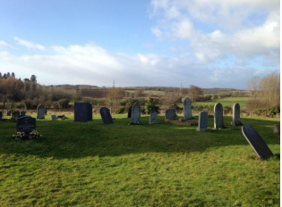
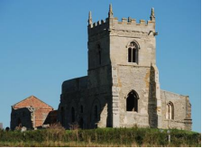
St Mary’s Church and Burial Ground
Originally Norman built (in 1115 on land occupied since Anglo-Saxon times), St Mary’s to its present state. St Mary’s is situated in a prominent position on the periphery of the village (why it was built on this particular site may never be satisfactorily answered). In terms of its more recent history, the church became disused and fell into disrepair when the Church of St John the Divine was built in the centre of the village.
St Mary's Church
However, the grounds of St Mary’s remain consecrated and are used as a final resting place for Colston Bassett residents. In 1994 a small, dedicated group undertook to arrest the decay and restore St Mary's is a Scheduled Ancient Monument and a Grade I listed building. Responsibility for its preservation and upkeep rests with English Heritage who undertake Inspections on an irregular basis (although anyone can report concerns directly to English Heritage). This is an excellent example of local people preserving a treasure they have been gifted for the benefit of future generations; it is clearly important that the Neighbourhood Plan should embrace the same principle. St Mary’s is highly valued by village residents, since its easily accessed location provides villagers with a haven of peace and tranquillity and glorious views over The Vale.
84% of questionnaire respondents felt St Mary’s was important/very important.
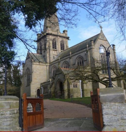
St John the Divine Church
St John the Divine was built in 1892 by Robert Millington Knowles of Colston Bassett Hall in memory of his eldest son and wife. The Church remains at the centre of village life.
St John's Church
Built in white stone in the early perpendicular style it is not ostentatious, but was described by Pevsner as “one of the most beautiful village churches in England” (The Buildings of England – Nottinghamshire, 1st Edition, Penguin Books, 1951). It is a Grade II listed building, standing majestically in a prominent position in the village centre and serving as home to the village war memorial (Grade II listed), commemorating the 14 villagers who lost their lives in the Great War. The church provides a spiritual sanctuary and extends a welcome to the entire village community. Activities organised by the church (usually in the Village Hall) include the ‘Souperbowl’ – a soup lunch offered once per month on Thursdays and a monthly ‘Breakfast in the Village Hall’ on Sundays during the summer, with both open to all.
67% of questionnaire respondents consider the church to be important/very important.
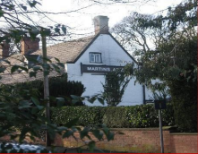
The Martin’s Arms Public House
Whilst at one time the village contained at least 4 public houses, the Martin’s Arms is the sole remaining establishment and is the epitome of an English country pub. Of Tudor origins the current building was originally a working farmhouse (late 17th century), and is another Grade II listed building. The pub was formerly an Estate property, but was acquired by its current owners in 1990. It is highly recommended in Michelin, Sawdays and AA Guides. Possessing an immaculately maintained interior, and located amidst beautiful gardens, it is ideal for meeting friends for good conversation in pleasant surroundings. The Martin’s Arms is also home to an award winning restaurant, and has been recognised as “The Nottinghamshire Dining Pub of the Year” 2012-2017. It represents a much valued and treasured asset. Continued patronage by villagers, their friends and guests, plus the active promotion of tourism are all important if the pub is to thrive.
Martin's Arms
76% of questionnaire respondents considered The Martin’s Arms to be important/very important, with 11 responses also indicating that the pub should be considered for listing as an ‘Asset of Community Value’. Community Action CF2: The Martin’s Arms pub is a key village asset that absolutely needs to be supported and kept open. The Parish Council will consider whether to register the pub as an Asset of Community Value.
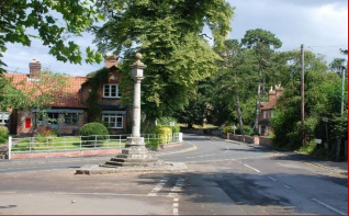
The Market Cross
This iconic structure is a National Trust property - the smallest in the East Midlands - and is situated in the very centre of the village. It marks the grant made to Ralph Bassett by Henry III of the right to hold a weekly market and an annual three day fair (1257). The vertical pillar was restored in 1831 on the original base to commemorate the Coronation of William IV. Repairs were made to the base in the 1980’s and again in 2013. The cross is designated an Ancient Monument (Grade II listed) and is maintained by English Heritage.
Market Cross
78% of questionnaire respondents considered the Market Cross as important/very important
Colston Bassett Dairy Shop
The shop is open for the purchase of beautifully presented, world renowned Colston Bassett Stilton and Shropshire Blue cheese, produced in the adjoining Dairy.
Situated on the south eastern edge of the village the dairy was established by the village doctor (Dr Windley) encouraging local farmers to form a co-operative and build a Dairy; land was purchased from Squire Robert Millington Knowles and the Colston Bassett & District Dairy opened in 1913. Products can be purchased on site; a website (www.colstonbassettdairy.co.uk) is available for more detailed information and online sales.
Dairy Shop logo
75% of questionnaire respondents considered the Dairy Shop as important/very important.
Cricket Pitch and Pavilion
The Cricket Pitch and Pavilion are situated in Washpit Lane on the northern outskirts of the village - a beautiful location, nestling between the renovated St Mary’s church and its modern replacement St John the Divine, and surrounded by wonderful trees and pasture land. In 2005, Colston Bassett Cricket Club was formed to preserve the long cricketing tradition within this idyllic location in the Vale of Belvoir. The pitch is well maintained and forms a pleasant open space for watching a game of cricket. The Estate generously allows the Club use of the land on an annual peppercorn rent basis. The Pavilion, which dates originally from the late 19th century, required extensive work in the early 1960’s to restore it from a derelict state into a serviceable facility.
Cricket match
Unfortunately the present condition of the Pavilion is very poor and it is in need of comprehensive upgrade. The Cricket Club has used several measures to raise money (Race Nights, a 100 club lottery etc.), but these have to date proved insufficient to generate the necessary funds. Plans to apply for grant funding from national sources for upgrades and modernisation, however, are effectively ruled out without first putting in place a much longer lease term agreement (e.g. 10-20 years).
67% of questionnaire respondents felt that the Cricket Pitch and Pavilion were important/very important Community Action CF3: The Parish Council will support the Cricket Club in its quest to obtain a long lease, and also provide support for grant applications in order to secure a sustainable future for the Cricket Pitch and Pavilion.
Telephone Kiosk and Defibrillator
The red telephone box standing in School Lane in a prominent position adjacent to The Martin’s Arms pub is a fine example of a K6 (GPO) telephone kiosk (Grade II listed structure). The kiosk is now the home of the village Defibrillator. Instructions for use are in place inside the kiosk together with the apparatus. However, at a time of high stress, and when very rapid response is required, prior knowledge and familiarity with the equipment is clearly desirable. Offering periodic open instruction sessions for villagers would be an obvious way to ensure that the equipment is used efficiently and effectively should the occasion arise.
K6 telephone kiosk
64% of questionnaire respondents stated this amenity was important/very important Community Action CF4: The Parish Council will facilitate regular training updates to ensure villagers are familiar with use of the defibrillator.
POLICY CF1: RETENTION OF COMMUNITY FACILITIES, AMENITIES, ASSETS - Developments leading to the loss of existing community facilities that are considered essential will not be supported unless it can be demonstrated that:
There is no longer any need or demand for the existing community facility; or
The existing community facility is, demonstrably, not viable using community support such as fundraising and volunteering by parishioners and others; or
The proposal makes alternative provision for the relocation of the existing community facility to an equally or more appropriate and accessible location within the Parish which complies with the other general policies of the Neighbourhood Plan.
The current facilities to which this policy applies are:
The Village Hall and the two adjacent paddocks
The Martin’s Arms Public House
St John the Divine church
The Colston Bassett Dairy
The Cricket Pitch and Pavilion
7.4.2 New and/or Improved Community Facilities, Amenities, Assets
Community consultation has confirmed the importance of enhancing the range of community facilities and amenities within the Parish, recognising their value to the local community. In recent times, however, the village has lost the valuable facilities of a shop, a state primary school, a post office, and a café. This, combined with a poor bus service, makes life difficult for those residents with no car, or those who become unable to drive due to advancing age or illness. Internet services are becoming the ‘normal’ way to access banking, and bank branches in nearby villages have been closed. This trend is likely to continue. Internet shopping is convenient for those who have access to broadband and who are computer literate, however, those residents without a car also tend to be those without I.T. facilities.
Community consultation in the questionnaire identified that 90% would like a Village shop, 80% would like a café, and 60% would like a children’s play area.
The commercial viability of establishing a new shop and/or café are challenging. In 2013 the Store and Café (located in The Old Telegraph Office) closed, as efforts to sell the business as a going concern failed. The Parish would, however, welcome and support any proposals for new facilities in line with Policy CF2.
Neighbourhood Watch
At present there is no Neighbourhood Watch scheme in operation in Colston Bassett. Responses in the consultation questionnaire confirmed that opinion is clearly in favour of such a scheme. A majority of respondents (55%) supported the formation of a Neighbourhood Watch scheme within the Parish, with 45% indicating they were ready to volunteer help if such a scheme were introduced.
Community Action CF5: The Parish Council will encourage and support the formation of a Neighbourhood Watch initiative within the Parish.
POLICY CF2: NEW OR IMPROVED COMMUNITY FACILITIES - Proposals that improve the quality and/or range of community facilities will be supported provided that the development:
Meets the design criteria stated in Policy D1;
Will not result in unacceptable traffic movements or other disturbance to residential properties,
Will not generate a need for parking that cannot be adequately catered for,
Is of a scale appropriate to the needs of the locality and conveniently accessible for residents of the village wishing to walk or cycle,
Takes into full account the needs of people with disabilities.
7.5 Transport and Road Safety
7.5.1 Traffic Management
Colston Bassett is a small rural Parish with a single main road forming the ‘spine’ of the village - Colston Rd/Hall Lane/Church Gate/Harby Lane – and which is also the connecting route between Cotgrave and Harby villages. Three smaller roads lead to nearby villages (Church Gate/Wash Pit Lane/Spring Hill/New Rd to Cropwell Bishop and Owthorpe Rd to Owthorpe), and two smaller roads (School Lane, Bunnison Lane) lead to farm properties. One final, important characteristic of village entry/exit roads is that both pass over single-track bridges, which are also listed structures - Hall Lane over the Smite Bridge and Wash Pit Lane over the China Bridge.
In 2008 a sub-committee of the Parish Council conducted a Traffic Survey in the village, which showed there were on average 1350 traffic movements/day through the village. The majority (94%) were cars/vans, with lorries/HGVs making up 4%, and motor cycles/cyclists 2%. Pedestrians (local residents and visiting walkers) and horses are also regular road users. After the A46 was dualled, with a new bridge over the A46 easing the route through Colston Bassett for Cotgrave/Harby traffic, the Traffic Survey was repeated (September 2017). Traffic volume had increased by 16%,with a daily average of one traffic movement/minute through the village and clear evidence of a commuting pattern (an early morning peak to the A46 and a late afternoon/evening peak away from the A46). The vehicle distribution was still dominated by cars/vans but the lorries/HGV contribution had almost doubled. The currently planned housing growth in the villages of Harby (+103), Hose (+57),Cotgrave (+350), and Cropwell Bishop (+160) will undoubtedly further increase traffic volume.
The National Planning Policy Framework encourages a reduction in greenhouse gas emissions through the introduction of measures which promote a decrease in the number of car journeys. There are several actions that can be taken by individuals and by the public and private sectors to support this objective, although the poor local bus service provision in the village effectively makes car ownership essential.
Both Open Day and Questionnaire consultations provided clear evidence of residents’ strong concerns regarding traffic safety and absence of appropriate traffic management arrangements in the village. Three particular concerns appeared:
Excess traffic speed in several areas, e.g. (i) the sharp, double blind bends close to the New Rd/Owthorpe Rd junction where vehicles often cross the central white line, and (ii) the Smite Bridge - only 4.3m wide with no pedestrian footpath, leading to dangerous situations (see (a) below). A give-way system with priority for vehicles leaving the village is in operation, but vehicles entering the village are often travelling too fast, since the speed limit in this location is (surprisingly) still 60mph; a 60mph speed limit also applies over the single track listed China Bridge.
The 3-way junction in the village centre at the Market Cross is the location of a sharp bend which is blind in both directions, made even more dangerous when cars park close to the bend; it is particularly dangerous when HGVs have to negotiate this bend (see illustration (b) below)
Church Gate near St John’s church is considered by residents to be the most accident prone road in the village. Its width is insufficient for two cars to pass safely and one vehicle often has to mount the pavement (see (c) below). A one-way/priority system as on the Smite Bridge is necessary here, currently often operated voluntarily by residents (see (d) below).
(a) Dangerous narrow Smite bridge(b) HGVs negotiating Market Cross bend(c) Two vehicle crossing on Church Gate requiring mounting of pavement(d) Voluntary operation of Church Gate 1-way system
To address the above concerns, the Questionnaire gathered residents’ opinions on a selection of possible traffic management/calming and speed control measures, which would lead to safer road use:
New speed limit signage – re-location of the 30mph signs on the 3 village entry/exit roads (Hall Lane, Harby Lane and Washpit Lane) much further from the village centre than currently; in addition a 20mph zone in the village centre, extending from just before the Smite Bridge on village entry to between the Harby Rd/Church Gate bend and Baker’s Lane on village exit,
Altered traffic management along Church Gate near St John’s church – e.g. a similar enforced one-way priority system as on the Smite Bridge,
Improved/extra signage for HGVs - additional and larger/clearer signage to inform and warn lorries/HGVs of the single track Smite/China Bridges.
To indicate community support for such measures, the percentage of Questionnaire responses, which were either supportive or strongly supportive were:
Current locations of speed signage inadequate - 84%
Excess traffic speed through the village centre - 72%
For movement of 30 mph signs away from village centre - 86%
For 1-way priority system on Church Gate - 76%
For 20mph zone along Church Gate - 71%
Community Action TRS1: Traffic Management - The Parish Council will develop a coherent action plan to address traffic and parking issues that have been identified in the Neighbourhood Plan including:
Continue to lobby with appropriate authorities for alternative and better-placed speed limit signage within the Parish,
Develop appropriate traffic management/calming measures for roads within the Parish identified in the Neighbourhood Plan as of high community concern, and lobby appropriate authorities for remedial action.
With specific regard to the HGV traffic through the Village, a question asked to gauge the level of community concern produced a ‘split’ response – 45% indicated high/strong concern but 42% indicated low/no concern. The most likely explanation for this is that since the volume of lorry/HGV traffic is low compared to car traffic (but has doubled in the last 8 years as noted above), some residents report not seeing any HGV problem, whereas those that have observed the HGV traffic through the village centre have seen how dangerous this can be (see photos above). Many respondents commented on the lack of “max 7.5 tonne except for access” signage close to the village on the entry/exit roads. The current signs are at the Cropwell Bishop end of Colston Rd and some distance away from the village on Harby Lane; there is no sign on the entry road over the narrow China Bridge. Many believe most HGV traffic is driving straight through the village rather than requiring access to village properties. A question on what measures would be welcomed to reduce HGV traffic produced 47 responses, with the most often occurring suggestions being the following:
Increased level of signage and use of illuminated signage to emphasis narrow bridges,
Enforcement of existing restrictions – perhaps by Parish Council contacting local Police to ask for advice on stricter application/enforcement of HGV ban, and/or to local hauliers/companies whose lorries/HGVs are observed to abuse current restrictions,
Use of a camera system to deter and/or identify regular offenders.
Community Action TRS2: HGVs - The Parish Council will engage transport authorities and, where necessary, the police:
to improve the visibility of signage for the 7.5tonneHGV limit, particularly in connection with the two bridge entries into the village,
to improve enforcement of the 7.5tonne HGV limit by identifying regular offenders and communicating with haulage companies whose lorries are in breach of the weight restrictions and are causing traffic problems within the Parish.
POLICY TRS1: TRAFFIC MANAGEMENT WITH REGARD TO NEW DEVELOPMENT - With particular regard to the rural highway network of the Parish and the need to minimise any increase in vehicular traffic all housing and commercial development must:
Incorporate sufficient off-road parking in line with housing policy D1;
Not remove or compromise the use of any existing off-road parking areas unless a suitable equivalent alternative is provided;
Provide any necessary improvements to site access, communal parking and the highway network either directly or by financial contributions;
Consider, where appropriate, the improvement and where possible the creation of footpaths to key village services.
7.5.2 Public Transport Provision
Local Bus Services - Colston Bassett has very limited bus services (Routes 850 and 852) which are used by very few people. Indeed, for those few residents who have no car of their own or who are unable to drive, carrying out routine day-to-day tasks such as shopping, going to the bank, and attending an appointment at the Cropwell Bishop Surgery is extremely difficult. Although many residents make good use of the internet for access to shopping and banking, it must be stressed that those residents who have no transport of their own are also likely to be those who have no access to the internet.
Observations from the traffic survey (Autumn 2017) recorded only 2 individuals travelling by bus over a monitoring period of three days, and it is a common sight to see the bus completely empty. The questionnaire identified only a very small number of infrequent users. No respondent travels to work by bus. Many residents question the economic viability of maintaining such a service that is clearly not meeting need. When asked for suggestions to make the bus service more attractive, comments focussed on frequency, reliability, but also the need for a service which travels at the right time and to the right destinations. It is clear that a radical re-think is called for.
It is intended to trial a voluntary community transport scheme, taking people to the doctors and the shops etc. 57 people responded in the questionnaire to say that they would help with driving, whereas just 10 said they have a need. In addition to private cars, the scouts at Cropwell Bishop have a minibus, which may be a suitable vehicle and economic option to facilitate small scale outings.
Community Action TRS3: Public Transport - The Parish Council will lobby the County Council to make realistic and economic changes to the service to better match the needs of residents.
7.5.3 Cycling
The Parish and surrounding rural areas are popular with leisure cyclists, particularly at weekends. 85% of respondents to the questionnaire agreed or strongly agreed that cyclists and walkers should be encouraged, however there was concern raised about the influx of large groups of cyclists. It is considered, however, that there is realistically no opportunity to designate cycleways given the nature of the narrow rural roads.
7.5.4 Parking
About 40% of respondents to the 2017 Questionnaire were of the opinion that the lack of village centre parking facilities and associated on-road car parking were causing such serious road safety issues as to require action. On-road car parking close to the blind bend near the Market Cross was mentioned particularly. The suggestion to use double yellow lines in this location produced a finely balanced response (41% in support and 45% against), with several comments that these were inappropriate for a rural location. On the other hand, the enquiry as to where off-road parking for the village centre should be located if it were introduced resulted in 32 suggestions for the paddock to the left hand side of the Village Hall. This is already used on an ad-hoc basis for Village Hall events, and is in exactly the right location to discourage the on-road parking causing most concern. As noted in sub-section 3.1.1, if this were designed as a permanent ‘Country Park’ style parking facility, this might form an acceptable solution.
Community Action TRS4: Parking - The Parish Council will endeavour:
To secure the ongoing use of the village hall left-hand paddock to provide car parking for daily use throughout the year.
To undertake an ongoing awareness exercise to make explicit the negative impact on inconsiderate parking.
7.5.5 Electric Vehicles
The UK government has recently announced its intention to ban sales of new petrol and diesel cars from 2040 to combat rising levels of air pollution (in particular NOx) and address climate change concerns. The implication is that the number of ‘pure’ electric vehicles (EVs) on the road (i.e. not hybrid) will almost certainly soon increase rapidly (there is some evidence this is already starting). If EVs are to have a similar range to today’s petrol/diesel cars, they will need to have large capacity batteries installed (for example, the 2018 Jaguar iPace is designed for a 290-mile range and has a battery capacity of 90kWh). This raises the crucial question of battery recharging. Residential charging is probably the current norm but using a typical generator size of 3.7kW (installed as standard on board current EVs and with similar electrical usage as a domestic kettle), this would take 19 hours to recharge the battery (assuming a typical run-down state of 25% of maximum). The lower capacity (and lower range <100miles) Nissan Leaf would take about 6 hours. The availability of larger capacity on-board generators (7kW) is emerging, which would halve these times, but this is then the maximum that would be possible using current standard domestic electricity supply (single-phase 240 volt). However, residential charging is only allowed where off-road parking is available. This issue is already influencing planning and building regulations; in London for example any new development that includes more than 5 parking spaces must include electric charging points in greater than 5% of these. It would seem wise to include a similar requirement for new developments even in locations such as Colston Bassett if rural communities are not to be left behind. Similarly, commercial rapid charging facilities are growing across the country (making use of 3-phase supply not possible at the domestic level and reducing the 7kW re-charge time by a factor of 3). These could be utilised in Colston Bassett by installation in a permanent parking area as described above, providing recharge possibility for residents with no off-road parking, and allowing opportunity fast re-charge for all residents.
POLICY TRS2: ELECTRIC VEHICLES - Residential development involving new-build or changes of use of one dwelling or more should provide 7kW cabling, or better if feasible, to the most practical point in the home to facilitate subsequent installation of a home electric vehicle charging point.
The provision of communal vehicular charging points within the Parish will be encouraged where there is universal access and their presence does not impact negatively on existing available parking in the Parish.
7.5.6 Pedestrian Paths/Pavements
At the Open Day consultation several comments were made about the poor quality and poor maintenance of roadside pedestrian paths/pavements within the village. The Questionnaire included a request to identify areas of concern. Around 52 specific comments were received, indicating a significant level of community dissatisfaction with the status quo. It would be appropriate if the Neighbourhood Plan contained actions to address the issues raised, particularly seeking to improve aspects such as upgrading areas of paths/pavements considered not fit for purpose, implementation of a regular maintenance programme, and enhancement of the exiting network of pavements/paths were this is needed. The most important (often mentioned) specific issues highlighted in the Community consultation are:
All pavements/paths in the Village Centre require levelling, with many having a steep, uneven camber or containing bad cracks,
Several areas of pavements/paths are narrowed because of outgrowing hedges,
The Colston Rd/Hall Lane pavement between New Road and the Smite Bridge is in urgent need of attention. Parts of the path currently have a poorly maintained part grass verge, which should be removed and the path restored to a full tarmac path,
The stretch on the bend near the Owthorpe Rd. junction is very bad,
The Church Gate path from the Market Cross to the Harby Lane bend requires considerable improvement (widening?) to be brought to an acceptable (safe?) standard,
School Lane from the paddock before the Village Hall to the road end requires considerable attention,
There is no footpath leading from the Village Centre to the bus stop in Harby Lane or to the Dairy – serious omissions,
Generally more frequent pavement sweeping/cleaning is required.
Traffic generation can be minimised by connecting development to the village via footpaths/providing broadband connections to support home working.
POLICY TRS3: PEDESTRIAN PATHS/PAVEMENTS - Developments will be supported where they maintain and where appropriate, upgrade or extend the pedestrian footpath network.
This should be achieved by:
Servicing new developments and connecting them to the existing pedestrian footpath network; and
Providing an improved and more extensive footpath network to support exercise and leisure activities for Colston Bassett Parish residents and visitors. The priorities are as follows:
Church gate – improved footpath for access to St John’s Church and the Village Hall
Harby Lane - New footpath to the Dairy
Sandpit Hollow – Improved accessibility for pedestrians
7.6 Business and Employment
7.6.1 Support for Existing Businesses and Employment
Good employment opportunities in the Parish and the strength of the community go hand in hand. Supporting the growth of employment opportunities in the Parish is therefore recognised as an important theme of the Neighbourhood Plan. 94% of respondents to the Colston Bassett 2017 consultation welcomed more business to the Parish. This response included 94% supporting new cottage industry businesses, 92% new home-based businesses, 91% a shop, 85% a café, 72% farm diversification, and 71% small workshops. Respondents did feel, however, that such new business should be in keeping with and not in detriment to the rural and predominantly residential nature of the Parish.
Colston Bassett is a rural parish but not too distant from several significant employment centres such as Nottingham, Grantham and Newark. Employment opportunities within the Parish are however limited in scale. The types of principal businesses and employers located within the Parish include: 1. Colston Bassett Dairy - Cheese maker 2. Colston Bassett School - Private Primary School 3. The Martin’s Arms Public House 4. Belvoir Boarding Kennels 5. Belle Vue Riding School/Livery Yard (home of Belvoir RDA (Riding for the disabled)) 6. Farms and related diversified businesses.
For most workers resident in the Parish the lack of significant local employment opportunity means that they must work away from the Parish. This impacts particularly on young people for whom the high property values and lack of starter homes, combined with the lack of local employment opportunities make Colston Bassett Parish an unattractive and difficult potential option for residence. Respondents showed a desire to reverse this situation and attract a younger demographic into the Parish.
There is an increasing trend for residents to work from home, whether this is for part of the working week or entirely. 19 individual respondents to the 2017 Consultation work from home. The survey also identified that 14 operate a business within the Parish, 10 employ others in their locally based business, and 19 are self-employed. 11 individual respondents are employed in Colston Bassett. With improving internet connectivity locally and changing employment patterns nationally, the trend for home working is likely to grow, making the Parish a place where a greater percentage of the population are spending their time within the Parish. This could create opportunities – for joint working, business hubs, support groups etc.
The largest employer is the Colston Bassett Dairy, which employs around 35 people most of whom travel from Grantham or Cotgrave. The high cost of housing, combined with the poor public transport was cited as the reason for this employment pattern. Lack of housing which is affordable and lack of public transport was also cited by the Martin’s Arms public house as a barrier to recruitment.
In order to protect and strengthen the economic base within the Parish, where there are buildings dedicated to business use in the Parish they should be protected against being lost to other uses.
POLICY BE1: SUPPORT FOR EXISTING BUSINESSES & EMPLOYMENT OPPORTUNITIES - There will be a strong presumption against the loss of commercial premises or land that provides employment. Applications for a change of use of land or buildings which would involve the loss of an existing employment opportunity will only be supported where:
The commercial premises or land in question has not been in active use for at least 12 months; and
The commercial premises or land in question has no potential for either reoccupation or redevelopment for employment-generating uses, demonstrated through results from both a full valuation report and a marketing campaign lasting for a continuous period of at least 6 months.
7.6.2 Support for New Businesses and Employment
New employment initiatives can help to boost and diversify the local economy, thus providing more local employment opportunities.
However, parishioners have been clear that any new employment initiatives should be small- scale and sensitive to the character of the Parish. Employment proposals should only be approved if they avoid harmful impacts on other matters agreed to be locally important such as increased traffic flows, parking, residential amenity, the preservation of historic/heritage assets and the local environment. In the 2017 Consultation questionnaire, concern was expressed that inappropriate commercial development within the Parish’s tranquil, rural setting could threaten the desirability of developing more appropriate business and employment opportunities.
The questionnaire also identified the desire for a village shop. It is acknowledged, however, that such shops are rarely viable as stand-alone businesses, especially since supermarket outlets, with their economies of scale, are situated in nearby Cropwell Bishop, Cotgrave, and West Bridgford. Consequently, support through fellow parishioners taking carless parishioners on shopping trips or encouraging the use of internet shopping is perhaps a more feasible option.
POLICY BE2: SUPPORT FOR NEW BUSINESSES AND EMPLOYMENT - In supporting additional employment opportunities, new developments will be required to:
Fall within the Settlement Boundary for the Colston Bassett Parish defined in policy S1, unless it relates to small scale leisure and tourism activities, community services and facilities, or small-scale employment generating development, retail and farm diversification;
Where possible development should be sited in existing buildings or on areas of previously developed land;
Be of a size and scale not adversely affecting the character, infrastructure and environment of the village itself and the Neighbourhood Plan area, including the countryside;
Not generally involve the loss of dwellings;
Not increase noise levels or light pollution or introduce any pollution to an extent that they would unacceptably disturb occupants of nearby residential property;
Not generate unacceptable levels of traffic movement and on-road parking, or make appropriate provision for adequate off-road parking;
Contribute to the character, the design of the local built environment and the vitality of the local area.
7.6.3 Home Working
In rural areas such as Colston Bassett Parish, with limited local employment opportunities, one benefit of supporting home working is that it helps to promote local employment activities whilst reducing the dependency of the car for long journeys to employment sites outside the Parish.
However, it is recognised that people may not have a suitable space within their home from which to run a business, or they may wish to distinctly and deliberately separate their work and living spaces. The construction of extensions, the conversion of outbuildings, and the development of new freestanding buildings in gardens from which businesses can operate will be supported. This is intended to maximise the opportunities for entrepreneurial activity and employment in Colston Bassett Parish.
Whilst it is acknowledged that it may not always be possible, there is also a strong desire for new housing to contain a small office space to accommodate home working.
POLICY BE3: HOME WORKING - Proposals for the use of part of a dwelling for office and/or light industrial uses, and for small scale free standing buildings within its curtilage, extensions to the dwelling or conversion of outbuildings for those uses, will be supported where:
Such development will not result in unacceptable traffic movements and that appropriate parking provision is made,
No significant and adverse impact arises to nearby residents or other sensitive land uses from noise, fumes, light pollution, or other nuisance associated with the work activity, and
Any extension or free-standing building shall be designed having regard to policies in this Plan and should not detract from the quality and character of the building to which they must be subservient by reason of height, scale, massing, location or the facing materials used in their construction.
7.6.4 Farm Diversification
Farm diversification can provide opportunities for the establishment and development of small businesses that generate income and employment opportunities for local people. Belvoir Boarding Kennels is an example of how farm buildings have been successfully utilised in a sustainable manner.
Diversification, supported by 73% of respondents to the questionnaire, will be encouraged to maintain a balanced and vibrant community, subject to the proper consideration of the impact on residents of any nearby houses and the broader community, visual or other impact on the countryside and highway safety issues.
New business development in the Parish should therefore: 1. Promote a viable and sustainable farming and rural economy in Colston Bassett Parish 2. Promote the diversification of rural businesses 3. Encourage new businesses to provide a wider range of local produce, services and leisure facilities, to provide local employment and attract visitors to the Parish 4. Maintain and enhance the local environment of rural and agricultural land.
POLICY BE4: FARM DIVERSIFICATION - In order to support farm diversification and the sustainable growth and expansion of businesses, the conversion of existing agricultural and commercial buildings will be supported subject to:
the development respects the local character of the surrounding area;
The development does not have an adverse impact on any archaeological, architectural, historic or environmental features;
The local road system is capable of accommodating the traffic generated by the proposed new use and adequate parking can be accommodated within the site;
There is no significant adverse impact on neighbours through noise, light or other pollution, increased traffic levels or increased flood risk.
7.6.5 Tourism
Colston Bassett is a beautiful rural parish to which walkers, horse riders, cyclists and other visitors are attracted. The Parish is keen to extend a welcome to visitors whilst ensuring that their visit does not have a negative impact on parishioners - for example, in the context of traffic.
The offer to visitors may be enhanced over the lifetime of the Neighbourhood Plan through the development of activities, places to eat and stay, in addition to infrastructure such as signage, seating, parking, information leaflets(walking guides) and other provision to welcome visitors to the Parish.
Community Action BE1: Tourism - The Parish Council will work with the community in developing a coherent action plan to maximise the positive experience of tourism to both Parishioners and visitors to the Parish.
POLICY BE5: TOURISM – Proposals to enhance tourism will be supported where the development:
Does not have a detrimental effect on the distinctive rural character of the Parish;
Does not adversely affect the surrounding infrastructure, particularly local road networks and water supply and sewerage;
Benefits the local community, through for instance, provision of local employment opportunities and improvements to local service provision, and is proportionate to the size of settlement in which it is located; and
Involves, where feasible, the re-use of existing buildings or is part of farm diversification.
7.6.6 Broadband and Mobile Infrastructure
The modern economy increasingly depends on high-quality communications infrastructure to reap maximum benefit from technological advances. High-speed internet connectivity drives business innovation and growth and creates business and employment opportunities. Online searching and transactions facilitate access to information and services, also providing new and easier opportunities for education and learning. The standard of broadband infrastructure is particularly important in rural settings such as Colston Bassett Parish, where high-speed broadband enables access to the ever-increasing number of online applications and services provided by both public and private sectors. Equally, access to a high-quality mobile signal is crucial for the rapid and always-available communication that makes up an increasing component of day-today life. Good broadband and mobile infrastructure can also contribute to reduced social exclusion.
Broadband provision in Colston Bassett was recently improved (mid-2016) by the installation of a BT Openreach FTTC (Fibre-To-The-Cabinet) service. However, the cabinet is located at the end of Owthorpe Road and hence is still some distance from most properties in the village. The need for residual copper connectivity between the cabinet and households reduces the maximum data speeds available typically by as much as 60%. Responses in both the Open Day and the Consultation Questionnaire in 2017, however, revealed that 44% still consider that the broadband service is poor or very poor, although 28% reported the service to be good or very good. This ‘split’ in opinion is probably caused by only some residents having upgraded their service to the highest level (i.e. most expensive) on offer commercially. Those that have will have benefitted from greatly improved broadband speeds; typically speeds of ~30Mbps are then possible (which then deserves the label ‘high-speed’, even though it is much less than the advertised ‘peak’ speed). Others are likely still to be operating in the 1-10Mbps range. In spite of this recent improvement, it is crucial to emphasise that continued progress is still necessary, enabling all businesses and households in Colston Bassett Parish to obtain access to an improved broadband service. New developments in communications technology are inevitable over the life of this plan (genuine ‘superfast’ broadband (>300Mbps) is starting to appear), and it is essential the Parish should take advantage of these for the benefit its Parishioners.
The 2017 questionnaire response to rating the quality of mobile phone service was even worse than for broadband. Over 70% of respondents consider the mobile phone reception is poor or very poor. There is undoubtedly some dependence between particular network service providers (some networks report ‘good outdoors, patchy indoors’), but, unlike broadband, there does not seem to be much evidence of concerted efforts to achieve improvement. The availability of a nearby-located mast is probably the only simple solution (the nearest is currently located just off the A46), but it is unlikely that this would be acceptable to village residents, unless this could be sympathetically located, and certainly must be shared by more than one provider.
POLICY BE6: BROADBAND AND MOBILE INFRASTRUCTURE - Proposals to provide improved access to faster broadband for residential and commercial dwellings will be supported.
Improvements to the mobile telecommunication network that serves all businesses and households within the Parish will be supported. If a new mast is installed, this must be shared where possible by more than one provider.
Any infrastructure improvements requiring above-ground installations must be sympathetically located (or preferably hidden from view), designed to integrate into the local area and not be in or near to open landscapes.
8. Monitoring and Review
The Neighbourhood Plan will last until 2028. During this time, it is likely that the circumstances which the Plan seeks to address will change.
The Neighbourhood Plan will be regularly monitored. This will be led by Colston Bassett Parish Council on at least an annual basis. The policies and measures contained in the Neighbourhood Plan will form the core of the monitoring activity, but other data collected and reported at the Parish level relevant to the delivery of the Neighbourhood Plan will also be included.
The Parish Council proposes to formally review the Neighbourhood Plan in 2023 or to coincide with the review of the Rushcliffe Local Plan if this cycle is different.
Appendix 1: Assessment of options for residential development
Assessment of Options for Residential Development
1. Background Context
To launch the Neighbourhood Plan process a consultation event was held in March 2017. Clear messages from that event were:
“The peace and quiet of the village, the rural location, with green fields, trees, and beautiful views across the countryside are highly valued. Access to pleasant walks, open green spaces, and living in an ‘unspoilt’ village are key features which make Colston Bassett an excellent place to live.”
“Residents of Colston Bassett are very happy with the current rural nature of their lovely village and a key message is a desire to preserve and protect it for future generations. Residents are proud of the local community facilities (Village Hall, paddocks, Market Cross, churches, pub, cricket pitch, open spaces) and value these highly.”
and specifically in respect of housing:
“Many are concerned that the current housing provision is inadequate in that the availability of small and affordable family homes is limited. Most respondents believe that a modest increase in smaller family homes is desirable, and link this to a desire to widen the diversity and age profile of the village.”
“The Village lacks smaller, more affordable homes for younger families. This opinion was linked to comments that the population tends to be mainly older, retired people, and that ‘new blood’ is needed to sustain the Village for the future.”
“There was a preference for a small number of modest family homes, suitable for young families and/or elderly people who may wish to ‘down-size’. This was linked to a desire for the families of local people to be able to remain in the village, and have access to affordable housing for those with a local connection.”
In addition, the ‘Housing Needs Report April 2017’ (Appendix 2) identified that:
59% households own their own homes, which is lower than regional (67%) and national (635) rates. 26.4% live in private rented accommodation, which is significantly higher than district (12%) and region (14%). It is assumed that this represents the estate properties which are privately rented.
The majority (55%) of residential dwellings are detached which is somewhat higher than the district (46%), regional (32%) and national (22%) shares.
More than two fifths (45%) of households live in houses with four or more bedrooms which is somewhat high when compared with the district (33%), regional (20%) and England (19%) rates.
Under-occupancy is higher than district, regional, national rates and the England Rural area average.
Domestic properties with Council Tax band G make up the largest group in the parish (approximately 23% of the total). It has a much higher proportion of properties with high value council tax bands, with 42% of dwellings having a Council Tax Band F or above against 13% for the district, 5% for the region and 9% for England as a whole.
Land Registry price paid data shows around 49 residential property sales were recorded in the Colston Basset Parish between 1995 and 2016. Detached housing accounted for the majority of sales, representing 82% of total sales during this time.
Limited supply of smaller family homes.
These findings largely reflect the responses received from residents at the Open Day launch event.
Subsequently a Questionnaire was issued to all residents in November2017. Key messages from that questionnaire were:
There is greater support for smaller homes for families and for older people, than for larger homes.
A clear preference was expressed for freehold properties, followed by rented housing with a local connection.
Careful, small development, which preserves the character of the village was shown to be important to many respondents.
68% of respondents wish for 10 new homes or fewer during the coming 10 years, and a further 20% favoured up to 15 new homes.
58% support or strongly support smaller sites of 5 houses or less.
There were mixed views on where these developments should be sited with the most popular being development of ‘brown-field’ sites, 74% support or strongly support.
Building on the edge of the village attracted 45% support or strongly support, and 37% support or strongly support infill sites only. 50% support or strongly support development of single dwellings on single plots. 26% support or strongly support building in gardens, whereas 51% demonstrated no or little support for this type of development.
2. Selecting appropriate and available sites for Consultation
The Working Group and all Theme Groups have been fully committed to taking account of both factual statistical data and the opinions of residents as highlighted above. Retaining the rural and open nature of the village, and protecting the environment, whilst finding appropriate sites for extra housing has been key in selection of potential sites.
2.1 Sites within the current Settlement Boundary
Very few sites within the current Settlement Boundary satisfy the criteria identified above, however these have were all included within the proposed new Settlement Boundary and thus continue to be available for windfall development, subject to obtaining planning consent. Indeed it is believed there is a possibility that 4 or 5 homes could be delivered in this way, although there is no guarantee that the owners of these plots of land will wish to develop homes which meet the criteria.
These sites are:
Land adjacent to the Martin’s Arms in School Lane
Land in Bunnison Lane (small Orchard)
Plus several garden spaces (although it should be noted that such sites were not supported by 51% of Questionnaire respondents).
All these sites are covered by the proposed Windfall Policy.
2.2 Additional sites for Consultation
In order to satisfy the clearly identified need for up to 10 additional homes over the Plan period, new sites outside of the original Settlement Boundary and at the edge of the village were considered essential to guaranteeing that this identified need would be deliverable. As there is realistically only one land owner (The Le Marchant Estate), there was no need to open up a landowners-consultation process to ask for potential site-build bids from a range of landowners. The Housing Theme Group took advice from its appointed consultant ‘Yourlocale’ and it was deemed acceptable and appropriate that a small team undertake a negotiation process with the single land owner.
Several meetings were held with the representative of the Estate (Jas Martin). As 74% of respondents to the questionnaire favoured development on ‘brown-field’ sites, it was first established with the Estate that there were no ‘brown-field’ sites available.
Some potential sites were initially put forward by the Estate (Private Road plus top of Spring Hill, see Map 1); members of the Housing Group had also proposed the bottom of Spring Hill (Map 1), a strip of land to the North of Harby Lane, plus a strip of land South of Harby Lane and stretching from Bakers Lane to the Dairy (Map 2). All these sites were considered to be in line with the opinions of residents in that they were all small (4/5 property capacity), edge of village, and largely protecting the open rural nature of the village. Also included was land on Spring Hill contained within The Elms, which was understood to be available for development according to the Conservation Area document (Map 1).
All the areas under consideration in Maps 1 and 2 were presented to the Parish Council at the 26 February 2018 meeting.
Map 1Map 2
2.3 Sites for Consultation
At a subsequent meeting with the Estate representative, some sites were eliminated for various reasons:
Private Road – not available, also not suitable (un-adopted road and difficulties in provision of gas/mains sewerage),
Bottom of Spring Hill – not available, also not suitable (difficulties in provision of gas/mains sewerage),
The Elms – not suitable due to impact on the Listed Building of St Mary’s Church,
South of Harby Lane – not available and not suitable to protect potential future Dairy expansion.
A new site was put forward by the Estate - South of Harby Lane and in the paddock adjoining Harby and Bakers Lanes. Their initial proposal was for an L-shaped site facing both Harby Lane and Bakers Lane. The Housing Theme Group were not in favour of the portion of the proposed site facing Bakers Lane due to road safety issues on this very narrow road, which is regularly used by large farm vehicles. The Theme Group therefore agreed to present the following sites to the Parish Council at its meeting on 16 April 2018, and with their agreement to put these forward to Consultation, see map 3 below.
Top of Spring Hill
North of Harby Lane
South of Harby Lane
Map 3
2.4 Consultation Open Day 21 May 2018
The next step was to present the sites for consultation with residents at the open Day event on 21 May 2018. The outcome of the Consultation event was:
Site 1 (North of Harby Lane) - 94% support
Site 2 (South of Harby Lane) - 76% support
Site 3 (Top of Spring Hill) - 86% support
Residents attending the Open Day were also invited to suggest alternative sites if they did not agree with those proposed. 14 sites were suggested and subsequently considered by the Housing Theme Group.
3 suggestions for various sites along Bakers Lane – These had been previously rejected as Bakers Lane is very narrow and used by farm vehicles. Developments could also impact on the listed Manor Farm.
6 suggestions for various sites along Bunnison Lane – Bunnison Lane regularly suffers from flooding making current properties inaccessible. The grazing paddocks along either side of Bunnison Lane at the centre of the village (BL1 and BL5) have also been identified as sites of Environmental significance (see Appendix 3) and in addition would impact on the listed St John’s Church and listed Manor Farm. One site along Bunnison Lane, a small orchard, has already been included within the proposed Settlement Boundary and is thus available for development as a windfall site.
1 suggestion for a site at the far end of Church Gate (West side) – This site is not available.
1 suggestion for areas next to the Church – Development here would impact on the listed building of St John’s Church. Additionally residents wish to preserve the open aspect and views in the centre of the village
1 suggestion for the other side of Spring Hill – This site is not available
1 suggestion for the area between the Martin’s Arms pub and Ascot House – This site is included in the proposed Settlement Boundary and is thus available for development as a windfall site.
1 suggestion for the end of School Lane – The large garden at the end of School Lane is included in the proposed Settlement Boundary and is thus available for development as a windfall site.
2.5 Opinion of Rushcliffe Borough Council
Rushcliffe Borough Council was consulted on the acceptability of the three proposed sites. The Borough Council considered sites 1 and 2 to be appropriate locations for development subject to meeting development plan policies. The Borough considered site 3 to be an inappropriate location for development as it was beyond the physical edge of the settlement and contrary to Policy 22 of the Publication draft of the Local Plan Part 2 which defines appropriate development in the countryside. This restricts countryside development to uses such as exception sites for affordable housing and those requiring a rural location such as agriculture, equestrian and forestry uses.
3. Feedback from the Estate
The information obtained through the consultation process plus the feedback from Rushcliffe Borough Council was presented to the Estate representative. The Estate made it clear that they would not support development for exception sites for affordable housing or those requiring a rural location such as agriculture, equestrian and forestry uses. In addition, other factors influenced their decision to eliminate site 3 at the top of Spring Hill, including lack of mains sewerage and gas, various complexities and difficulties relating to construction cost which would not be economically viable. He two remaining sites 1 and 2 will be made available by the Estate for development.
Appendix 2: Housing Needs Report
Colston Bassett Parish Council Neighbourhood Plan Housing Needs Report
April 2017 (prepared by YourLocale)
Colston Bassett Parish Neighbourhood Plan Housing Needs
Introduction
This report provides an analysis of housing issues in the Colston Bassett Parish area to support its Neighbourhood Plan policies. The report draws on the latest available data from the Census, Land Registry and Office for National Statistics, small area model-based income estimates and local consultation exercises. The results outlined in this Housing Needs Survey Report and any future Housing Needs Survey will influence the policies of the Colston Bassett Parish Neighbourhood Plan.
It should be noted that Census data for Parishes is built up from output areas which are the smallest geographical unit for which Census data is released, and thus, they act as the basic “building-blocks” for the creation of other “higher” geographies, eg wards, council areas, etc.
Colston Bassett is a very small parish comprising of just one output area (E00144813). This output area also takes in neighbouring Tythby which is situated outside the parish boundary. Figure 1 illustrates the parish and census output area boundaries.
Figure 1 Colston Bassett and Tythby Parish and 2011 Census Output Area Boundaries
Population Age Profile
According to the 2011 Census, Colston Bassett and Tythby had an estimated population of 399 residents living in 163 households dispersed across 1,747 hectares. There were 2 vacant dwellings representing a 1% vacancy rate. Since 2001 the number of residents living in the Parish is estimated to have increased by around 15% (51 people). The number of dwellings (occupied and vacant) also increased, rising by 20 (14%).
At the time of the 2011 Census around 20% of residents were aged under 16 which is slightly higher than the district, regional and national (19%) rates. Around 62% of residents were aged between 16 and 64 which was lower than the district (63%), regional and national (65%) rates. Older people (aged 65+) represented 18% of total residents which is close to the district rate but higher than the regional (17%) and national (16%) rates. The median age of people living in the Parish was 48 which is older than the district (42), region (40) and national (39) rates.
Usual Residents by Age Band 2011
Description
Colston Bassett and Tythby
Number
Colston Bassett and Tythby
Percentage
Rushcliffe
Percentage
East Midlands
Percentage
England
Percentage
Aged 0-4
16
4.0
5.8
6.0
6.3
Aged 5-15
63
15.8
12.8
12.5
12.6
Aged 16-64
248
62.2
63.1
64.5
64.8
Aged 65+
72
18.0
18.4
17.1
16.3
All Usual Residents
399
100.0
100.0
100.0
100.0
Median Age (not percentage)
48
48
42
40
39
A more detailed breakdown of age bands reveal that at the time of the 2011 Census Colston Bassett and Tythby had a somewhat higher proportion of residents aged between 10 to 19, 40 to 49 and 50 to 59.
Colston Bassett population by age band
There is also evidence of an ageing population with the proportion of residents aged 65 and over increasing from 13.2% in 2001 to 18% in 2011. The Census shows that the number of residents aged 65+ rose by 57% (26 people) during this period.
Research shows the number of older people will grow significantly in the future and relative growth will be highest in older cohorts. Latest available population projections1 suggest that Rushcliffe’s 65 plus age group is forecast to grow by around 53% between 2014 and 2034.
Deprivation
The English Indices of Deprivation measure relative levels of deprivation in 32,844 small areas or neighbourhoods, called Lower-layer Super Output Areas (LSOAs) in England. The Colston Bassett parish is situated within LSOA E01028420 which also includes three other villages (Tythby, Langar and Barnstone). The overall Index of Multiple Deprivation Decile (where 1 is most deprived 10% of LSOAs) (IMD) shows this area on the whole displays relatively low levels of deprivation and is ranked within the 8th decile on the overall 2015 Index. However, on closer inspection of the domain indices, the area falls within the 1st decile in terms of barriers to housing and services and is ranked within the most deprived 7% in England. This domain measures the physical and financial accessibility of housing and local services. The indicators fall into two sub-domains: ‘geographical barriers’, which relate to the physical proximity of local services which the area performs fairly badly on and ‘wider barriers’ which includes issues relating to access to housing such as affordability.
Economic Activity
The following table illustrates the working status of usual residents aged 16 to 74. In Colston Bassett and Tythby this accounts for 72% of the population. At 74% Colston Bassett and Tythby’s economic activity rate was higher than the district (72%), regional (69%) and national (70%) rates. When compared to the district, regional and national rates, Colston Bassett and Tythby has a higher than average share of self-employed residents and at the time of the 2011 Census, the unemployment rate was relatively low.
Economic Activity and Inactivity 2011
Description
Colston Bassett and Tythby
Number
Colston Bassett and Tythby
Percentage
Rushcliffe
Percentage
East Midlands
Percentage
England
Percentage
All Usual Residents Aged 16 to 74
287
100.0
100.0
100.0
100.0
Economically Active Total
212
73.9
71.9
69.3
69.9
Employee, Full-time
111
38.7
40.5
38.8
38.6
Employee, Part-time
35
12.2
14.6
14.4
13.7
Self Employed
50
17.4
9.9
8.7
9.8
Unemployed
6
2.1
2.8
4.2
4.4
Full-time Student economically active
10
3.5
3.3
3.3
3.4
Economically Inactive Total
75
26.1
28.1
30.7
30.1
Retired
44
15.3
15.9
15.0
13.7
Student including Full-Time Students
13
4.5
5.5
5.8
5.8
Looking After Home or Family
9
3.1
3.0
4.0
4.4
Long-Term Sick or Disabled
3
1.0
2.2
4.1
4.0
Other
6
2.1
1.5
1.9
2.2
Household Size
At the time of the 2011 Census, the average household size in Colston Bassett and Tythby was 2.4 people which is in line with the district and England rates and slightly below the 2.3 regional rate. The average number of rooms per household stood at 7.1 in line which is higher than the district (6.2), regional (5.6) and England (5.4) averages. The average number of bedrooms per household stood at 3.5 which is higher than the district (3.1), region (2.8) and England (2.7) rates.
Housing Characteristics
Tenure
Home ownership levels are relatively high with around 59% of households owning their homes outright or with a mortgage or loan. However, this is lower than the district (77%), regional (67%) and national (63%) rates. Over a quarter (26.4%) of households live in private rented accommodation which is significantly higher than that of the district (12%), region (14%) and national (15%) rates. Around 8% of households live in social rented accommodation which is in line with the district rate but below regional (16%) and national (18%) rates.
Housing Tenure 2011
Description
Colston Bassett and Tythby
Number
Colston Bassett and Tythby
Percentage
Rushcliffe
Percentage
East Midlands
Percentage
England
Percentage
All occupied Households
163
100.0
100.0
100.0
100.0
Owned; Owned Outright
53
32.5
39.2
32.8
30.6
Owned; Owned with a Mortgage or Loan
43
26.4
37.5
34.5
32.8
Shared Ownership (Part Owned & Part Rented)
5
3.1
0.7
0.7
0.8
Social Rented; Rented from Council (Local Authority)
1
0.6
2.3
10.1
9.4
Social Rented; Other
12
7.4
6.1
5.7
8.3
Private Rented; Private Landlord or Letting Agency
41
25.2
12.2
13.6
15.4
Private Rented; Other
6
3.7
1.1
1.3
1.4
Living Rent Free
2
1.2
0.9
1.3
1.3
Accommodation Type
Data from the 2011 Census shows that the majority (55%) of residential dwellings are detached which is somewhat higher than the district (46%), regional (32%) and national (22%) shares. There is a higher than average share of semi-detached housing which accounts for around 36% of the housing stock against 31% for the district, 35% for the region and 31% nationally. Terraced housing, flats and apartments provide just 8% of accommodation spaces which is significantly below the district (22%), region (32%) and national (47%) shares.
Accommodation Type 2011
Description
Colston Bassett and Tythby
Number
Colston Bassett and Tythby
Percentage
Rushcliffe
Percentage
East Midlands
Percentage
England
Percentage
All household spaces (occupied + vacant)
165
100.0
100.0
100.0
100.0
Detached
91
55.2
46.2
32.2
22.3
Semi-Detached
59
35.8
31.0
35.1
30.7
Terraced
14
8.5
11.4
20.6
24.5
Flat, Maisonette or Apartment
-
0.0
10.6
11.7
22.1
Caravan or Other Mobile or Temporary Structure
-
1.0
0.8
0.4
0.4
Number of Bedrooms and Occupancy Rates
More than two fifths (45%) of households live in houses with four or more bedrooms which is somewhat high when compared with the district (33%), regional (20%) and England (19%) rates. There is an under representation of housing for single people with just 1% of dwellings having one bedroom against 6% for the district, 8% for the region and 12% for England as a whole.
Household size by number of bedrooms 2011
Description
Colston Bassett and Tythby
Number
Colston Bassett and Tythby
Percentage
Rushcliffe
Percentage
East Midlands
Percentage
England
Percentage
All households
1,311
100.0
100.0
100.0
100.0
1 bedroom
35
2.7
6.0
8.3
12.0
2 bedrooms
295
22.5
26.7
26.5
27.9
3 bedrooms
720
54.9
45.5
45.4
41.2
4 or more bedrooms
261
19.9
21.9
19.8
19.0
There is evidence of under occupancy in the parish (having more bedrooms than the notional number recommended by the bedroom standard). Analysis of the 2011 Census shows that around 55% of all occupied households in Colston Bassett and Parish have two or more spare bedrooms and around 32% have one spare bedroom. Under occupancy is higher than district, regional, national rates and the England Rural area average.
Colston Basset
plus 2 or more - 55.2%
plus 1 - 31.9%
0 - 11.0%
minus 1 - 10.8%
minus 2 or more - 0
Rushcliffe
plus 2 or more - 49.5%
plus 1 - 33.9%
0 - 15.0%
minus 1 - 1.5%
minus 2 or more - 0.1%
East Midlands
plus 2 or more - 38.5%
plus 1 - 36.4%
0 - 22.0%
minus 1 - 2.7%
minus 2 or more - 0.4%
England
plus 2 or more - 34.3%
plus 1 - 34.4%
0 - 26.7%
minus 1 - 3.9%
minus 2 or more - 0.7%
England Rural Average
plus 2 or more - 47.3%
plus 1 - 34.4%
0 - 16.5%
minus 1 - 1.6%
minus 2 or more - 0.2%
Under occupancy in the parish is particularly evident in larger properties with more than half (52%) of households with 4 or more bedrooms occupied by just one or two people.
Household with 4 or more bedrooms by household size 2011
Description
Colston Bassett and Tythby
Number
Colston Bassett and Tythby
Percentage
Rushcliffe
Percentage
East Midlands
Percentage
England
Percentage
Households with 4 or more bedrooms
66
100.0
100.0
100.0
100.0
1 person in household
8
12.1
10.2
10.4
106
2 people in household
26
39.4
33.6
32.3
30.3
3 people in household
13
19.7
18.3
18.8
18.3
4 or more people in household
19
28.8
38.0
38.5
40.8
Census data also suggests that older person households are more likely to under-occupy their dwellings. Data from the 2011 Census allows us to investigate this using the bedroom standard. In total, around 81% of pensioner households have an occupancy rating of +2 or more (meaning there are at least two more bedrooms that are technically required by the household) and is somewhat higher than the 48% non-pensioner household rate.
Bedroom Occupancy - Older Persons Households in Colston Bassett and Tythby 2011
All households
plus 2 - 55.2%
plus 1 - 31.9%
0 - 11.0%
minus 1 - 1.8%
Pensioner households
plus 2 - 80.6%
plus 1 - 19.4%
0 - no data
minus 1 - no data
Single pensioner households
plus 2 - 70.6%
plus 1 - 29.4%
0 - no data
minus 1 - no data
Non-pensioner households
plus 2 - 48.0%
plus 1 - 35.4%
0 - no data
minus 1 - no data
Overcrowding is not a significant issue in the parish, however, research shows that households with dependent children are more likely to be overcrowded. The Census implies there is some evidence of a small number of families with dependent children living in overcrowded households in Colston Basset.
Bedroom Occupancy - Family Households in Colston Bassett and Tythby 2011
All households
plus 2 - 55.2%
plus 1 - 31.9%
0 - 11.0%
minus 1 - 1.8%
Households with no children
plus 2 - 78.8%
plus 1 - 21.2%
0 - 0%
minus 1 - 0%
Households with dependent children
plus 2 - 34.6%
plus 1 - 36.5%
0 - 23.1%
minus 1 - 5.8%
Housing Market
Council Tax Bands
The chart below provides a breakdown of the proportion of dwellings in Colston Bassett and Tythby by council tax band compared to the district, region and national averages at 2011. Domestic properties with Council Tax band G make up the largest group (approximately 23% of the total) in the parish. It has a much higher proportion of properties with high value council tax bands with 42% of dwellings having a Council Tax Band F or above against 13% for the district, 5% for the region and 9% for England as a whole.
Dwelling Stock by Council Tax Band
Residential Sales
Land Registry price paid data shows around 49 residential property sales were recorded in Colston Bassett and Tythby between 1995 and 2016. Detached housing accounted for the majority of sales, representing 82% of total sales during this time. Around 14% were semidetached and 4% terraced properties. It should be noted that not all sales are captured by the Land Registry, for example properties that were not full market value, right to buy and compulsory purchase orders will be excluded.
Volume of House Sales by House Type 1995 to 2016
There is very little evidence of new build housing market activity in the parish with just one new build sale occurring in 1999. It should be noted that not all new builds will be captured in the Land Registry price paid data, e.g. some conversions and social housing units will be excluded.
Housing Affordability
The publication of ONS House Price Statistics for Small Areas presents an opportunity for detailed housing affordability analysis.
The data reveals the cost of an entry-level3 property on average across England and Wales has increased by almost 20% in the last decade, to £140,000 (year ending June 2016). For new properties, the price was nearly £180,000. The data4 also shows that home-ownership prospects vary across the country.
In the Colston Bassett Parish area5 a low to mid-priced property costs on average £199,950 which is somewhat higher than the national average. Assuming a 15% deposit6 , those entering the property market in the area would require a household income of £45,394 (£26,444 E&W average) and savings of £33,492 which is a challenge for many households.
With the average cost7 of an entry-level home in the area being £199,950 prospective buyers would require an estimated £2,000 for legal and moving costs, £1,499 for stamp duty and £29,992 for a 15% deposit, coming to £33,492 in total.
Summary of Future Housing Need
At the time of the 2011 Census, Colston Bassett and Tythby was home to around 400 residents living in 163 households. Analysis of the Census suggests that between 2001 and 2011 the parish population increased by around 15% (51 people). During this period the number of dwellings rose by 14% (20).
The area has a higher proportion of residents aged between 10 to 19, 40 to 49 and 50 to 59 but there is also evidence of an ageing population with the share of residents aged 65 and over increasing from 13.2% in 2001 to 18% in 2011. The Census shows that the number of residents aged 65+ rose by 57% during this period. In line with national trends the local population is likely to get older as average life expectancy continues to rise. Around 59% of households own their homes outright or with a mortgage or loan but at 26% the share of households living in private rented accommodation is very when compared with district, regional and national rates.
There is evidence of under occupancy suggesting a need for smaller homes of one to two bedrooms which would be suitable for residents needing to downsize, small families and those entering the housing market. Providing suitable accommodation for elderly residents will enable them to remain in the local community and release under-occupied larger properties onto the market which would be suitable for growing families. There is a predominance of detached housing and high value council tax banded properties.
Land Registry price paid data indicates very little new build housing in the parish over recent years.
Deprivation is not a significant issue in the parish. However, the area is ranked within the most deprived 7% in England in terms of barriers to housing and services which is largely due to its physical proximity to local services. The high price of housing in the area will make it difficult for those on lower and middle incomes to enter the local housing market.
Appendix 3: Environmental Inventory
A full environmental survey was documented in an Environmental Inventory (Appendix 3A). The inventory is accompanied by a map (Appendix 3B) of the whole Parish area broken down into individual plots of land, each plot linked to its respective inventory record.
Environmental inventory: Process
The aim of the environmental inventory is to provide some form of objective assessment for identifying sites of environmental significance for the purposes of the Neighbourhood Plan. An environmental inventory (covering the entirety of the Plan area) of Colston Bassett was carried out between February and October 2017. The work comprised two elements:
Review of all existing designations and available information, and
Fieldwork to identify sites and features of natural and historical environment significance in the context of the Plan Area.
The review compiled information from many sources, including:
DEFRA
Natural England
Historic England
Nottinghamshire and Rushcliffe Records
Environment Agency
British Geological Survey
Old maps (Ordnance Survey, manuscript)
Local history and archaeology publications
Local knowledge
Local consultation.
The fieldwork reviewed all open and currently undeveloped land in the Plan Area, and significant species, habitats and, landscape characteristics. The data, along with all relevant site-specific information from the existing information review, were mapped and tabulated, and each site was scored and evaluated using the nine criteria for Local Green Space selection in the National Planning Policy Framework 2012. See below.
The scoring system was the used to identify sites that would be put forward for designation as Local Green Spaces or Other Sites of Environmental significance.
Generally, sites scoring 75% (24/32) or more were designated as Local Green Spaces. Other sites of environmental significance included those recorded as Priority Habitats by Natural England; Local Wildlife Sites (LWS);sites identified as being of high biodiversity significance in the context of the Plan Area, in particular grazing paddocks within the village centre and parcels of land of known local historical or special significance.
These were then submitted as the consultation day outlining the draft policies, receiving support in the range 94-96% for these designations.
Environmental inventory: Criteria scoring.
Accessibility:
0 - private
1 - public Right of Way along margin
2 - public Right of Way through centre
3 - several public Right of Ways
4 - fully public
Proximity:
0 - distant
1 - 3 or 4 fields away from village
2 - within a couple of fields of village
3 - adjoining village
4 - within village
The boundary for purposes of proximity was defined by the areas of housing.
Bounded:
Typically every parcel of land in your parish is fully bounded - ie easily definable - therefore they all score 4. Scores less than 4 are only for poorly defined sites, which are very rare in heavily farmed and populated areas.
Special:
Valued features defined to a certain extent by the public consultation a. In particular, points added for woods/copses/grazing fields in proximity to the village or if a significant setting e.g. close to St Mary’s Church.
Recreational/Educational use:
Fully public, well used spaces like playgrounds score 4. Most fields are 0. However additional points if there was a public Right of Way and added 2 if it was used frequently.
Beauty (max 2 points):
Partly based on public consultation data, and generally a positive score but marked down if next to working agricultural/factory units.
Tranquillity (max 2 points):
As previous, generally a positive score but marked down if next to working agricultural/factory units and busy roads.
Historical Significance:
A score of 4 for scheduled monuments - a high level of existing designation.
3 for sites where there has been archaeological finds or other significant historical evidence to the village
2 was used mostly for fields with very good ridge and furrow or old orchards
1 was used mainly for fields with remnant ridge and furrow or ponds
Wildlife (out of 4):
4 - any SSSIs, nature reserves, local wildlife sites or areas known to be important for priority species, fields adjoining Smite or Smite tributary (reflecting it’s designation by Rushcliffe as a biodiversity corridor) , special feature e.g. orchids or heronry. 3 - long established grazing lands, significant hedgerows, Priority Habitats identified by Natural England
Below this, aggregated scores for habitat features:
+1 for any water (ditch/pond etc)
+1 for scrub/trees/good sized hedgerow
+1 for each if either extensive
Most of the farmed agricultural fields score 0
Appendix 3A
Local Green Space Areas
Local Green Space Areas - environmental appraisal
Map ref.
Summary Description
Access
Proximity
Bounded
Special
Recreation/ Education
Beauty
Tranquillity
History
Wildlife
Total Score
NR4
Historic churchyard and site of St Mary’s church (Listed). Ivy covered blue lias limestone wall bounded on 4 sides with stile across to field. Small elm tree copse on south east corner. Nesting birds, barn owls and bees in the church walls. Open views over rolling countryside to the NW and towards Belvoir Castle to the SE. Natural England Priority Habitat – Wood pasture and Parkland(NEPH-WP)
4
4
4
4
4
2
2
4
3
31
SH3
Cricket and croquet pitch. Bounded by recently planted hedging behind cricket pavilion and ancient hedging lined by old oak trees along Smite Tributary. Outlying maize crop, wildlife meadow and grazing area by Washpit Lane and Smite. Well used recreational area of importance to community, footpath along one side and access to Cricket Pitch from Washpit Lane. NEPH –WP. High risk of surface water flooding
3
4
4
4
4
2
2
3
4
30
NR3
Jubilee Walk. Public footpath to St Marys Church bounded by unmanaged hedgerow with mature ash trees. Lined with lime trees recently planted by the Jubilee group. Old concrete water trough, open views. Special in context of access to St Mary’s. NEPH-WP
2
4
4
4
4
2
1
3
2
26
NR6
Arable field. Former "park area" now ploughed Mature tree and hedging boundary with Hall Grounds . Recent planting of mixed deciduous trees adjacent to mature plantation of oak trees in one corner. Footpath from Hall to Cricket Ground lined with semi mature trees on one side, joining footpath to St Mary's church on another side. Mature hedgerow bordering Smite tributary. Rich wildlife habitat with wide variety of butterflies. Partial high risk surface water flooding. NEPH-WP
3
4
4
3
3
2
1
2
4
26
SL1
Village paddock used for grazing. Historical orchard with some residual apple trees. Bounded by unmanaged hedging on one side and garden with mature shrubs/trees on another. Important open aspect from pub (listed) and amenity area for village use in association with Village Hall, with permission from the Estate
3
4
4
4
3
2
1
2
3
26
HL3
Arable Field behind CB Hall. Former "park area" now ploughed but with significant pockets of tree clusters and freestanding trees, including some major oak within the ploughed area. Public footpath runs along one side from cricket pitch to Pollards bridge lined by new wildlife hedge, now mature. Mature tree hedging on border with Hall. Heronry. Unmanaged wild areas around tree clusters. Interesting gully from Hall to Cricket pitch lined with mature oak trees. Wide unmanaged field margin along Smite boundary. Partial flood zone 3. Wildlife rich habitat (NEPH – WP)
1
4
4
3
3
2
2
2
4
25
NR5
Arable field. Bounded by a River Smite tributary on the Southern side, managed hedge with a gateway on to New Road and public footpath. Heritage strips for wildlife on two sides of the field. Overgrown wildlife habitat and wild flowers. Water springs and recent mole drainage. Open views towards/from the church, Recent geo-thermal survey revealed Roman Saxon artefacts. Partial high risk surface water flooding. NEPH-WP
2
4
4
3
2
2
1
3
4
25
SH1
Arable field. Open views over the Cricket Pitch towards Belvoir Castle . Mature hedging with ancient woodland belt on one side. River Smite tributary on another side bordered by unmanaged hedging and oak trees and public footpath past the St Mary's church. 3 mature trees in centre of field. Recent geo-thermal survey revealed Roman and Saxon artefacts. Special in context of St Mary’s . NEPH-WP
0
4
4
3
3
2
2
3
4
25
SH4
Arable field. Open views to St John's Church and the River Smite. Bounded by the cricket pitch, the River Smite and recently planted hedging with some ancient trees on the boundary with the public footpath. Small copse of well maintained and recently planted, mixed trees in corner by China Bridge. Heavily wooded and overgrown wide bank margins. Access down one boundary to Cricket Pitch from Washpit Lane. Former "park" area. Special in context of cricket and croquet pitch. Partial flood zone 3. NEPH –WP
2
4
4
2
3
2
2
2
4
25
NR2
Grassland, until recently planted with maize. Bordering Smite tributary. Partial high risk surface water flooding. Tall unmanaged hedges on all sides Border shared with NR6, row of 10+ mature oak trees which marks route of historic track to St Mary's church NEPH-WP
0
4
4
2
2
2
1
2
4
21
Other sites of environmental significance
Other sites of environmental significance - appraisal
Map ref.
Summary Description
Access
Proximity
Bounded
Special
Recreation/ Education
Beauty
Tranquillity
History
Wildlife
Total Score
Church Gate
St John's Church. (Listed) Late 19c church surrounded by mature trees and rookery. Significant bat colony within church
4
4
4
4
4
2
2
4
3
31
China Bridge
Late C18th Grade II Listed. Weak, humpback bridge over the River Smite with single-span arch. Course square stone with brick vault and swept sides. Three course brick voussoirs; north side rendered. Chamfered copings. Autumn survey: colonised by grey and orange, drought resistant lichens and some moss. Vault colonised by molluscs, arachnids and other invertebrates. King fisher sightings
3
3
4
2
2
2
1
4
4
25
HL2
On one side of footpath, part of historic parkland. Public footpath through grounds from HL3 through to Hall Lane. Natural England Priority Habitat Woodpasture and Parkland and Deciduous Woodland (NEPH - WP and DW)
2
4
4
3
2
2
1
4
1
25
SL6
Arable field. Two footpaths regularly used by the community and walkers. Bounded by the River Smite with mixed hedging and trees on one side and managed hedging along the bridleway. Important open views towards the escarpment and surrounding countryside and views back towards village. Partial flood zone 3
3
3
4
3
3
2
2
0
4
24
CG1
Small area of paddock, fenced on three sides, important parking amenity for village events parking with permission from farmer. Managed hedge adjoining road with small hawthorn tree
3
4
4
3
3
2
1
0
1
21
Hol19
Hose Lane Verge. Designated Local Wildlife Site. Verges of varied sward type with a rich unimproved meadow flora. The north west section has a wet ditch (great willowherb is abundant) with meadowsweet and tufted hair-grass suggesting waterlogged conditions
4
0
4
2
4
2
1
0
4
21
SH2
Bellevue Stables. Grazing paddocks and stock proof fencing with ménage. Unmanaged hedging. Mature woodland, Bellevue Spinney on corner of New Road and Spring Hill containing old farm buildings. Historic woodland dating back to early 19c. NEPH-WP
0
4
4
3
4
1
1
1
3
21
CG2
Small copse adjoining Smite, possible historic location of Chapel of St Ivo and graveyard. Evidence of old bridge in river bank. Recently site of heronry although unclear if still in residence. Broad mix of deciduous trees. Partial flood zone 3
0
4
4
2
0
2
1
3
4
20
HL1
The Vicarage. (Listed) Estate fencing to the front. Stock fencing on other boundaries. Mature trees and woodland. Grass paddocks and parkland. Small copse of mature trees adjoining Hall Lane
0
4
4
2
0
2
1
4
3
20
SL13
Deciduous woodland and partial arable field. Old deciduous woodland with rookery. Bounded by Smite on one side with regularly used footpath along edge. Centre recently replanted. Natural England Priority Habitat – Deciduous Woodland (NEPH -DW)
1
2
4
2
2
2
2
0
4
19
HL4
Hall Grounds and Hall Grounds Drive. Open views to St Mary's. Mature woodland with many specimen trees. (NEPH - WP and DW)
2
4
4
2
0
2
1
1
3
19
Langar Lane Verge
From Langar Lane - ancient, mixed, deciduous hedges. LHS - avenue of horse chestnut trees from HyL to LL3. along wide verge - P.C. initiative in the Eighties and planted by volunteers. RHS Maintained dykes on both sides. Mostly, maintained ancient, hedges along field boundaries. Grassed verges vary in width along both sides of Langar Lane. Wider verges have an abundance of established wild flowers. Well-established shelter belts of mixed deciduous trees including blackthorn near public footpath. Considerable wildlife LL7 and LL23 and LL24 unmanaged hedging (mostly elm) and well established shelter belt (larger elm trees) Designated Local Wildlife Site on section adjoining LL25 Risk of surface water flooding
4
2
4
0
2
1
1
0
4
18
NR23
Blanche’s Gorse. Mixed mature woodland. Natural England Priority Habitat – Deciduous Woodland(NEPH – DW). Occasionally used for recreational shooting(pheasants). Mixed conifer and deciduous
0
3
4
2
2
2
2
0
3
18
NR24
Grazing field, recently re-sown. Ridge and furrow still evident. Bridleway down centre. Bordered by Blanche’s Gorse on one side. Managed hedging and freestanding trees elsewhere. Spring marked on western boundary (OS Maps)
2
3
4
0
2
2
1
1
3
18
OW6
Arable field with Smite along one boundary, regularly used footpath along edge. Remnants of old avenue of trees in middle (3 mature trees). Unmanaged hedging on two side, Smite boundary, mixed trees/hedging . Small stream running down to Smite on NE edge
1
2
4
0
2
2
2
1
4
18
SL11
Arable field. Bounded by Smite on one side with mixed hedging and trees, managed hedging on two sides interspersed with mature trees. Footpath, partially, on two sides, both well used.
2
2
4
0
2
2
2
0
4
18
WP lane verge
Wide verges on both sides with old, mature trees, mostly oak. Feeder stream from LHS flows under the lane into River Smite between WL2 and WL3. Flood zone 3
4
3
2
2
2
2
1
0
2
18
CG4
Grazing field, bordered by River Smite on one side and gardens on the other side. Willow trees bordering Smite, unmanaged hedge separating it from footpath down one side. Partial flood zone 3
0
4
4
2
0
2
2
0
4
18
CG5
Grazing field, bordered by River Smite on one side and gardens on the other side. Footpath running along one side, separated by unmanaged hedge. High/medium risk of surface flooding on border of Smite
0
4
4
2
0
2
2
0
4
18
CG6
Grazing field, bordered by River Smite on one side and gardens on the other side. Partial flood zone 3. Grazing field, bordered by River Smite on one side and gardens on the other side. Partial flood zone 3
0
4
4
2
0
2
2
0
4
18
CG7
Grazing field, bordered by River Smite on one side. Mixed hedge and semi mature trees along Church Gate, comprising lime, ash and sycamore. Deep managed hedge along Washpit Lane interspersed with young trees. Mature oak and ash along Smite. Partial flood zone 3
0
4
4
2
0
2
2
0
4
18
HL5
Sandpit Hollow. Small copse and pond on corner of Owthorpe Road and Hall Lane
0
4
4
2
0
2
1
2
3
18
SL7
Grazing paddock. Located behind the Martins Arms(Listed). Bounded by mature trees adjoining River Smite and mature trees along border of gardens backing on from School Lane. Seven substantial freestanding trees, oak, ash and chestnut Remnants of ridge and furrow. Partial flood zone 3
0
3
4
2
0
2
2
1
4
18
BL1
Large grazing field. Mixed boundaries of unmanaged/ managed hedging and gardens/fencing. Three mature free standing ash in middle. Wildlife significance as it forms part of core area of pastureland in centre of village. Trace of old ridge and furrow/undulating
0
4
4
2
0
2
2
1
3
18
CG3
Grazing field, bordered by River Smite on one side and mature trees/unmanaged hedges on three sides. Five mature sycamore and one chestnut in verge bordering road. High/medium risk of surface flooding from Bunnison Lane. Open views towards Colston Bassett Hall
0
4
4
2
0
2
1
0
4
17
LL9
Arable. Field margins, especially wide along the Stroom Dyke. Large, mature hedging on two sides, with fencing along the Stroom Dyke. Previous site of two cottages, demolished in the 1980s, Footpath through middle. Mounded remains include a deep well; large, mature tree, bushes and good wildlife habitat. Field adjacent to dairy pasture; considerable wildlife – skies awash with Hirundiniae in summer months and at least six species of raptor including hobbies/barn owls. Pond on far side. High risk of surface water flooding and flood zone 3 from Stroom
2
0
4
0
2
1
2
2
4
17
NR11
Edmonthorpe Lodge. Grade 2 Listed building. Well maintained orchards. Belvoir Boarding Kennels. Natural England Priority Habitat – Traditional Orchard adjoining house. Small grazing paddock to front
0
2
4
2
0
2
0
4
3
17
OW4
Small arable field, bordered by Smite tributary on one side and containing two small copses in the corners. One copse contains historic pumping station (the Ram) that was used to feed water to Colston Hall. Boundaries mix of unmanaged /managed hedge, interspersed with trees
0
2
4
0
0
2
2
3
4
17
SL2
Paddock and copse. Overgrown grazing paddock with small copse of mature trees (mainly horse chestnut and sycamore). Mature trees bordering one side. Important wildlife area in village centre offering diverse habitats. Brick wall along road viewed as significant
0
4
4
2
0
2
1
1
3
17
WPL2
Small triangular, set aside field. Rich wildlife habitat. Large variety of perennial plant life: thistles, teasels and general wildlife diversity. R. Smite forms one boundary. Flood zone 3. Natural England Priority Habitat – Grazing Marsh
0
3
4
1
1
2
2
0
4
17
HyL9a
Spinney replanted early 2000 with mixed deciduous saplings. Also mixed, unmanaged, deciduous hedging, which has grown well along Harby Lane. Good wildlife habitat includes damson trees; snowdrops; tawny owls, little owls and bats. This area was once the village dump. Backs onto the remains of an old orchard with mixed fruit trees - apple, pear, damson. Risk of surface water flooding. NEPH-DW
0
4
4
2
0
1
1
2
3
17
BL2
Managed mowed paddock, historically grazed. Boundaries mix of managed and unmanaged hedgerows. Managed mowed paddock, historically grazed. Boundaries mix of managed and unmanaged hedgerows
0
4
4
2
0
2
2
0
3
17
BL4
Large grazing field adjoining farm buildings and dairy with managed hedging on two sides, including two mature ash trees on Bunnison lane. Unmanaged hedge on Harby Lane with immature ash and chestnut. Tall leylandii hedge by farm buildings
0
4
4
2
0
2
1
0
3
16
BL7
Grazing field. Unmanaged hedges down two sides. Adjoining farm buildings on one side and gardens on another side. Traces of ridge and furrow
0
4
4
2
0
2
2
1
3
18
OW1
Historic deciduous woodland dating back to early 19c, bordering Owthorpe Road. Mixed conifer and deciduous. Footpath running along one edge. Natural England Priority Habitat – Deciduous Woodland (NEPH – DW)
1
2
4
2
2
2
1
0
3
17
SH6
Grazing field adjoining Bellevue Stables. Small copse of trees and unmanaged hedging along Spring Hill. Wide unmanaged hedge on border with SH5. NEPH-WP
0
4
4
2
0
2
2
0
3
17
SL3
Grazing paddock. Slight ridge and furrow. Wildlife pond installed in last 10 years with abundant newts and sightings of grass snakes. Bounded on 3 sides by unmanaged hedging including one mature ash. Two groupings of trees in corners comprising small copses of semi mature trees planted within last 20 years
0
3
4
2
0
2
2
1
3
17
WPL1
Grazing field Rich pasture land down to the River Smite. Open views. Wide bank margins along the Smite with hedging and mature trees. Steep banks to the river. Flooding. Remains of hedging along other field margins and some mature trees. Small copse in middle and larger copse at end adjoining WPL4
0
3
4
2
0
2
2
0
4
17
NR1
Mature woodland. Bounded by old stone wall for 30 metres. Private road (Hall Grounds Drive) on the other side. NEPH-DW
0
4
4
2
0
1
1
1
3
16
BL3
Grazing paddock adjoining farm, managed hedging on two sides
0
4
4
2
0
2
1
0
3
16
BL5
Grazing paddock Managed hedge down two sides, adjoining churchyard and farm buildings
0
4
4
2
0
2
1
0
3
16
BL6
Grazing field. One managed/two unmanaged hedge down three sides. Adjoining farm buildings on one side. Traces of ridge and furrow
0
4
4
2
0
2
1
1
3
17
SL10
Grazing field. Managed hedgerows and trees. Shallow pond with a variety of trees
0
2
4
2
0
2
2
1
3
16
SL9
Grazing field. Bounded by managed hedging on two sides and unmanaged on one side. Traces of ridge and furrow
0
2
4
2
0
2
2
1
3
16
HyL13
Kaye Wood. Old deciduous woodland, recognised on early 19 century maps. Historically used for recreational shooting. Natural England Priority Habitat – Deciduous Woodlands
0
2
4
0
2
2
2
0
3
15
HyL12
Arable field bordering Kaye Wood on South East with large field strip and old deep pond, Kaye Wood Pond, identified as Designated Local Wildlife Site by Rushcliffe BC.
0
3
4
0
0
2
2
0
4
15
CR6
Mature Woodland on corner of Colston Road and New Road. Part felled recently but now re-established. NEPH- DW. Mixed deciduous and conifer with some specimen sequoia. Wooded area dating back to early 19 c
0
3
4
2
0
2
1
0
3
15
HL7
Arable field, bordered by Smite on one side and tributary on another. Flood zone 3 and large pond/wetland in south east corner marking prior course of Smite. Open view towards Colston Hall from west
0
3
4
0
0
2
1
1
4
15
NR9
Winifred Wood. Wildlife habitat. Sightings of foxes, sparrow hawks and buzzards. Natural England Priority Habitat- Deciduous Woodland
0
2
4
0
2
2
1
0
4
15
SH5
Arable field. Currently maize. Wide strip of unmanaged hedging along Spring Hill. Unmanaged hedging on two more side. NEPH-WP
0
4
4
0
0
2
2
0
3
15
WPL4
Arable field. Narrow field running along Smite, with LL8 on opposite boundary with mixed hedging and trees. Unmanaged hedging and trees along Smite. Smite designated Local Wildlife Site along this section. Small copses north end
0
3
4
0
0
2
2
0
4
15
CR4
Mature woodland (Old Gorse) within CR3. Area defined as important deciduous woodland but mixed conifers/deciduous trees. Bordered by Smite tributary on one side. Associated with recreational shooting. Natural England Priority Habitat – Deciduous Woodland (NEPH – DW)
0
2
4
0
1
2
2
0
4
15
CR2
Arable field bounded by Grantham Canal and Swabs Lane. Managed hedging but mixture of trees and unmanaged hedging alongside Grantham Canal. Grantham canal designated Local Wildlife Site
0
2
4
2
0
2
1
0
4
15
HoL13
Historic deciduous woodland dating back to early 19c, footpath down one side. Natural England Priority Habitat – Deciduous Woodland (NEPH –DW)
1
0
4
0
1
2
2
0
3
13
NR14
Small spinney of mature trees on New road marked on 19c maps as site of Lime Works
0
1
4
0
0
2
1
2
3
13
Sites not designated local green space or of environmental significance
Sites not designated local green space or of environmental significance - appraisal
Map ref.
Summary Description
Access
Proximity
Bounded
Special
Recreation/ Education
Beauty
Tranquillity
History
Wildlife
Total Score
HyL9
Toft Hill. Arable. Pasture until five years ago. Four old, laid and maintained hedges. A few mature trees in hedges, mainly ash, used by owls. Extensive draining during the late early Nineties, destroyed traces of ridge and furrow. Elm in hedging. Open, panoramic view of the Vale and village. Public footpath across field to stile on Harby Lane and towards Hose Lane
2
3
4
0
2
2
1
0
3
17
LL1
Arable. Gated; with well maintained footpath through crop from Harby Lane, across centre of field to Langar Lane. Hedges on three sides. Open views. Stile to footpath through spinney in far corner. Ancient, mixed and maintained hedges, bordering Harby Lane.
2
4
4
0
2
2
1
0
2
17
Harby Lane verge to Dairy
RHS towards Harby. Ancient, well grown, mixed hedge with maintained dyke and naturalised margin. Variety of maturing trees. Wide verge, with some wild life and trees. Mown by volunteers. Bus stop and shelter near corner of Bakers Lane. LHS towards Harby - narrow verges bordering maintained dyke. Accident risk from turning milk lorries/buses/tractors
4
4
4
0
1
1
1
0
2
17
HoL16
Pen Hill, large arable field with good views around vale and pond surrounded by trees. Two footpaths crossing middle
3
0
4
0
3
2
2
0
3
17
SL8
Arable Field. Footpath across the middle. Bounded by managed hedging on all sides. Mixture of willow and ash trees in one hedgerow Footpath well used for recreational purposes. Open views to the escarpment
2
3
4
0
2
2
2
0
2
17
HL8
Small copse of old deciduous trees and pond reflecting old course of Smite. Flood zone 3
0
3
4
2
0
2
1
1
3
16
HyL8
Arable. Old, maintained hedging with some mature trees, mainly ash. Wide field margins. Three gates. Open views across to Kaye Wood, the Vale of Belvoir and village. Risk of surface water flooding. Public footpath across field to stile on Harby Lane
2
2
4
0
2
2
1
0
3
16
LL2
Arable. Four old established hedges. No field margins. Pond and small copse in one corner. Footpath along edge.
1
3
4
0
2
2
2
0
2
16
LL4
Arable. Managed hedges mixed with trees. No field margins. Footpath through middle
2
2
4
0
2
2
2
0
2
16
NR20
Arable. Two maize fields, bordering Smite tributary. Bridleway along common boundary. Mixed hedging and trees along boundaries. Partial high risk surface water flooding
1
2
4
0
1
2
2
0
4
16
NR21
Grazing field. Recently re-sown. Footpath down one side, bordering Smite tributary on one side. Mixed hedging and trees along boundaries. Partial high risk surface water flooding
1
2
4
0
1
2
2
0
4
16
NR25
Arable field: Bridleway towards Cropwell Bishop on north side. Managed hedging with some freestanding trees
1
3
4
0
2
2
2
0
2
16
OW2
Arable field bordered by Owthorpe Road and tributary of Smite. Regularly used footpath along one edge. Managed hedge but unmanaged/trees along tributary
1
2
4
0
2
2
1
0
4
16
OW3
Group of three arable fields with regularly used footpath along boundaries. Mixture of managed/unmanaged hedging with row of trees along footpath. Small section of Smite tributary along SW border, deciduous woodland to NW
1
2
4
0
2
2
2
0
3
16
OW5
Arable field with Smite tributary running down the middle, bordered by Smite on one side and adjoining section of important deciduous woodland. Managed hedging round other borders. Footpath through middle alongside tributary
2
2
2
0
2
2
2
0
4
16
SL12
Arable field. Bounded by Smite on one side with mixed hedging and trees and old deciduous woodland (Kaye Wood) on another. Managed hedging two sides. Well used footpath alongside Smite
1
1
4
0
2
2
2
0
4
16
HoL2
Former grazing field with traces of ridge and furrow, recently ploughed, bounded on one side by Smite and Smite tributary. Managed hedging along one side. Footpath follows Smite in corner towards Hickling
1
0
4
0
2
2
2
0
4
15
HyL7
Arable. Four mature, maintained hedges. Wide field margins. West hedge bounded by Kaye Wood. High risk of surface water flooding. Public footpath across centre of field from HyL 8 to double bend on Harby Lane. Bridge and stile across dyke. Panoramic views
2
1
4
0
2
2
1
0
3
15
LL7
Arable field. Four unmaintained, old hedges full of winter berries. Pond in far corner. 20m wide field margin on Langar Lane side. A few mature trees in hedgerows, mainly ash, some oak. Adjoining solar farm. Track to solar farm, no admittance. Mixed hedging, containing mostly elm, bordering Langar Lane. Good wildlife. Footpath across middle. Risk of surface water flooding
2
1
4
0
2
1
2
0
3
15
NR22
Grazing field. Recently re-sown, bordering Smite tributary on one side. Mixed hedging and trees along three sides. Blanche’s Gorse wood along north side with thick unmanaged hedge border. Partial high risk surface water flooding
0
3
4
0
0
2
2
0
4
15
WPL3
Arable field R. Smite along one side. Copse forms boundary at bottom of Spring Hill. Flood zone 3
0
3
4
0
0
2
2
0
4
15
CG8
Small orchard of semi mature trees. Unmanaged hedge bordering road with three medium ash trees
0
4
4
0
0
2
1
0
3
14
CR1
Two arable fields bordering Colston Road to the south, with footpath running through the middle. Adjoining important deciduous woodland to south east, with managed hedging interspersed with trees, mainly chestnut along Colston Road but three large mature trees on footpath. Wildlife strip on north side interspersed with trees including 5 mature oak specimens
1
2
4
0
1
2
1
0
3
14
CR3
Group of 5 arable fields, bordered by Grantham Canal, Colston Road, Owthorpe Road and tributary of Smite. Narrow coppice of trees alongside Colston Road and tributary with two areas of woodland in the middle, used for recreational shooting, and one small coppice opposite New Road. Small coppice beside Grantham Canal NEPH-DW
0
2
4
0
1
2
1
0
4
14
HoL7
Three grazing fields to east of Hills farm. Remnant of small pond in one, managed hedges. Footpath through middle
2
0
4
0
2
2
1
0
3
14
HyL9b
Pasture - remains of old orchard. Four stock proof fences. Farm access only. Some mature trees along west side; ash and lime, also wild Damson trees. Small flock of Jacob’s sheep. Good insect life
0
4
4
0
0
1
1
1
3
14
LL6
Arable field. East Smite Hill. Adjoining solar farm Footpath through middle. Managed hedging interspersed with trees
2
1
4
0
2
1
2
0
2
14
SL4
School playing field
0
3
4
2
2
1
1
0
1
14
HL6
Arable field. Woods on two sides, high risk of surface flooding on north west side. Smite tributary along one side
0
3
4
0
0
1
1
0
4
13
HoL15
Group of four arable/grazing fields in proximity to Roses Farm and Colston Hills farm, footpaths running through middle
2
0
4
0
2
2
1
0
2
13
HoL17
Two arable fields Managed hedging interspersed with occasional trees. Bordered by Hose Lane. Footpaths across middle
2
0
4
0
2
2
1
0
2
13
Hyl2
Arable. Three ancient, maintained hedges, with some mature trees, mostly ash. Maintained dyke alongside Harby Lane. More mature trees on far side of field and ancient rabbit warren along hedgerow. Large pylon. Wide, maintained field margins. Used by dog walkers and horse riders. Open access to the next field. Good wild life. Open views
0
3
4
0
1
2
1
0
2
13
NR10
3 x interlinked ploughed fields. Bounded by River Smite, Winifred Wood and maintained hedging. Heritage strips. Post and wire fence enclosing woodland. Smite designated Local Wildlife Site bordering fields north of Winifred wood
0
1
4
0
0
2
2
0
4
13
NR27
Two arable fields adjoining New Road. Wide field margin on section from Edmonthorpe Lodge to Spring Hill with mature trees. Unmanaged hedge dividing the two fields. Managed hedging elsewhere
0
3
4
0
0
2
1
0
3
13
NR7
Arable field with set a side wild flower area (includes ragwort). 4 maintained hedges including mature trees at the bottom of the field. Open views across the Vale. Avenue of old horse chestnut trees on New Lane. Field includes sub station and telegraph poles
0
3
4
0
0
2
1
0
3
13
SL14
Partial arable field. Bounded by Smite on one side with mixed hedging and trees. Flood zone 3
0
1
4
0
0
2
2
0
4
13
SL5
Two Arable fields. Bounded by managed hedging interspersed with occasional trees
0
3
4
0
0
2
2
0
2
13
CR5
Grazing field with old hedgerow down middle. Unmanaged hedging on 4 sides. Adjoining Colston Road on one side
0
2
4
0
0
2
1
0
3
12
HoL1
Group of 10 broadly arable fields forming south west boundary of parish running along Smite tributary. Tributary bordered by trees and unmanaged hedging. Managed hedges interspersed with trees elsewhere
0
0
4
0
0
2
2
0
4
12
HyL10
Arable field bordering Bunnison Lane Farm. Managed hedging
0
3
4
0
0
2
1
0
2
12
HyL11
Arable field bordering Kaye Wood on South East with large field strip. Managed hedging on other margins
0
3
4
0
0
2
1
0
2
12
HyL3
Arable. Four, old, maintained hedges. Wide, maintained field margins; good wild life; migratory birdlife; butterflies. Used by dog walkers/hacking
0
2
4
0
1
2
1
0
2
12
HyL5
Arable. Four old, maintained, hedges. Mature trees in hedgerows. Wide field margins; Good wild life. Migratory birds. Open views. Stroom Dyke forms third boundary - steep sided dumble habitat. Risk of surface water flooding.
0
1
4
0
0
2
2
0
3
12
LL21
Arable. Six metre field margins. Mixed, mature hedging on three sides. Two mature trees in hedgerows. Field runs down to the Stroom Dyke and dumbles, which forms the fourth boundary. Stroom devoid of major water life
0
1
4
0
0
2
2
0
3
12
LL24
Arable. Wide hedgerow/shelter belt on Langar Lane with sizeable elm trees - rare in this area. Field boundaries consist of three hedges and Stroom Dyke. Very few mature trees in hedge lines. Open views. Considerable bird life from adjacent, ridge and furrow, dairy herd pastures (Langar)
0
0
4
0
0
2
2
1
3
12
LL3
Arable. Pond in far corner with willow trees. Bounded by mature, maintained hedging along Langar Lane. Large electricity pylon. Horse chestnut plantings on Langar Lane finish. Number of semi-mature ash in hedge line. Birdlife. Recent sightings of English partridge and woodcock
0
2
4
0
0
2
2
0
2
12
NR26
Group of 3 arable fields to west of New Road and adjoining Home Farm, bounded by managed hedging interspersed with freestanding trees. Some wildlife strips
0
3
4
0
0
2
1
0
2
12
NR8
Arable Field with 4 wide heritage strips. 4 maintained hedges and a good selection of mature trees. Deep dyke towards Langar with culvert. Bordering on to Winifred Wood with very tall maintained ancient hedge. Open views across the Vale and to St Johns
0
2
4
0
0
2
1
0
3
12
Hol11
Two grazing fields, bounded by Hose Lane to the east. Footpath running down edges to the west. Managed hedging interspersed with occasional trees. Small pond in northeast corner by road
1
0
4
0
1
1
1
0
3
11
HoL12
Grazing field Managed hedging interspersed with occasional trees but bordered by copse on south side
0
0
4
0
0
2
2
0
3
11
HoL8
Grazing field with linear copse on north side, managed hedging, interspersed with occasional trees
0
0
4
0
0
2
2
0
3
11
HyL4
Arable. Bounded by four old, maintained hedges - maintained dykes; mature trees in hedgerows. Wide field margins. Shelter belt of trees in far corner. Open views
0
2
4
0
0
2
1
0
3
11
HyL6
Arable. Maintained, old hedging, with some mature trees. Two laid hedges along Harby Lane. Stroom Dyke forms third boundary - steep sided dumble habitat; well maintained but bereft of water wild life. High risk of surface water flooding Plenty of birdlife, including winter migrants. Open views across the Vale and Belvoir Castle
0
1
4
0
0
2
1
0
3
11
LL20
Arable. Mature, mixed hedging on four sides – two not maintained and one very patchy. No field margins. Few mature trees. Large electric pylons across centre of the field. Ancient rabbit warren, with fluctuating population, between boundaries of LL20 and HyL2
0
2
4
0
0
1
2
0
2
11
LL23
Private residence. Property, surrounded by a post and rail fence, stands in the middle of the plot, which runs down to the Stroom Dyke. Semi-mature tree planting. Evidence of old orchard. Large, grassed area. Open views. Wildlife, especially hares. Mature, unmanaged mixed hedge runs along Langar Lane
0
0
4
0
0
2
2
0
3
11
LL25
Grazing paddock. Small triangular field Old, unmaintained mixed, deciduous hedging and stock proof fencing. Wild life impact from adjacent ridge and furrow fields
0
0
4
0
0
2
2
0
3
11
NR12
Arable field bordering Edmonthorpe Lodge and Winifred Wood. Managed hedging where not bordering Winifred Wood
0
2
4
0
0
2
1
0
2
11
NR13
Two arable fields bordering Edmonthorpe Lodge with New Lane on eastern side. Managed hedging.
0
1
4
0
0
2
2
0
2
11
HoL10
Three arable fields, bounded by Hose Lane to the east. Footpath running down edges on western side. Managed hedging interspersed with occasional trees
1
0
4
0
1
1
1
0
2
10
HoL18
Arable field. Managed hedging interspersed with occasional trees
0
0
4
0
0
2
2
0
2
10
HoL3
Arable field, bordered by Kaye Wood to North with large pond and copse in NE corner, adjacent to farm buildings. Hills Farm and Kaye Wood Farm
0
0
4
0
0
2
1
0
3
10
HoL5
Group of 14 arable fields. Managed hedging interspersed with trees. Home Farm located in middle
0
0
4
0
0
2
2
0
2
10
HoL6
Grazing field, with remnant of old pond on south side. Managed hedges. Hills farm at one end
0
0
4
0
0
2
1
0
3
10
HoL9
Two grazing fields on corner of Harby/Hose Lanes. Small Copse bordering road. Managed hedges. Farm entrance
0
0
4
0
0
2
1
0
3
10
LL10
Arable. Field runs alongside the River Smite towards the weir. Wide field margins along Smite. Pylons across field. Good mature hedging along Langar Road (Cropwell Bishop) Barbed wire fence runs from the weir along the River Smite. Partial flood zone 3. Adjoins solar farm
0
0
4
0
0
1
1
0
4
10
LL22
Arable. Mature, mixed hedge along Langar Lane – Stroom Dyke and dumble boundary on far side. Post and rail fence to private residence
0
0
4
0
0
1
2
0
3
10
LL5
Arable. Managed hedging, with some trees. No field margins. Risk of surface flooding Farm access only. Langar Lane runs down one side
0
1
4
0
0
1
2
0
2
10
HoL14
Arable field Managed hedging interspersed with occasional trees. Bordered by driveway and Hose Lane
0
0
4
0
0
2
1
0
2
9
HoL4
Arable field, bordered by Kaye wood on N side, farm buildings on two sides. Managed hedging two sides
0
0
4
0
0
2
1
0
2
9
LL8
Solar Farm. Unmaintained hedging on three sides; growth encouraged to disguise solar farm. Small, newly planted copse. Risk of surface water flooding.