Ruddington Neighbourhood Plan
Ruddington Neighbourhood Plan 2011 - 2028
June 2021
Contents
- Introduction
- Background and context
- Engaging the community
- Vision and objectives
- The spatial strategy for Ruddington
- Policy overview and compliance with objectives
- Village centre policies
- Housing policies
- Connectivity policies
- Heritage policies
- Economy policies
- Design and sustainability policies
- Environment policies
- Community infrastructure policies
- Monitoring and review
- Glossary
- Appendices
Appendices
Appendix 1 - Non-designated heritage assets list
Appendix 2 - Green infrastructure network
Appendix 3 - Local green spaces
Appendix 4 - List of community projects to be supported by CIL
Appendix 5 - Ruddington Design Guide: Part 1 Character Assessment
Appendix 6 - Ruddington Design Guide: Part 2 Design codes for minor development
Appendix 7 - Ruddington Design Guide: Part 3 Design codes for major and strategic development
Appendix 8 - Core Documents List
Maps
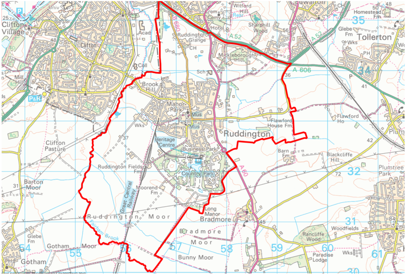
Map 1 - Neighbourhood Plan Area
Map 2 - Spatial strategy – Sub-regional context
Map 3 - Spatial strategy – Parish context
Map 4 - Spatial strategy – Village centre context
Map 5 - Acceptable uses in the village centre
Map 6 - Ruddington Pedestrian Strategy
Map 7 - Key views, landmarks and gateways within the Ruddington Design Guide
1. Introduction
What is Neighbourhood Planning?
1.1. Neighbourhood planning is a central government initiative introduced by the Localism Act 2011 and recognised in the
National Planning Policy Framework (NPPF). Neighbourhood planning aims to empower local communities to use the planning system to promote suitable and sustainable development in their area. Neighbourhood Plans must be in general conformity with the strategic policies of the Development Plan and take into consideration national policy and guidance.
1.2. The Development Plan comprises the Local Planning Authority’s planning policies that set out the strategy for development of
houses, employment land, and other uses over a certain time period, known as the plan period. In the case of Ruddington,
the Development Plan consists of the Rushcliffe Local Plan Part One (2014) and the Rushcliffe Local Plan Part Two (2019). To
assist consistency and conformity the Ruddington Neighbourhood plan period is the same as the Local Plan period and extends to 2028.
1.3. Alongside the Rushcliffe Local Plan the RNP is also part of the Development Plan and a statutory document used to decide if planning applications within the Neighbourhood Plan Area (see Map 1), should be given planning permission. Aspirations within the RNP will be used to drive forward other projects in the village that do not fall within the remit of land use planning.
Preparing the Ruddington Neighbourhood Plan
1.5. In October 2017, Rushcliffe Borough Council designated Ruddington Parish as the Neighbourhood Plan Area, following an application from the Parish Council. Following this, Ruddington Parish Council commenced the preparation of the RNP with the help of a number of volunteer residents, Parish Councillors and other stakeholders. Urban Imprint, a town planning and urban design consultancy, were also commissioned to assist the group with the preparation of the plan.
1.6. In preparing the Neighbourhood Plan, a number of local volunteers gave their time to carry out community consultation and prepare a range of comprehensive documents that form the evidence base and underpin the policies within this plan.
1.7. Creation of a Neighbourhood Plan for Ruddington will give local residents influence in the planning decisions affecting their
local area in terms of the types of development to come forward, as well as setting high standards of design and sustainability.
Who will use the Neighbourhood Plan?
1.8. The RNP seeks to assist a range of stakeholders, including the following:
- Landowners and home owners proposing development (of a range of types and scales) within Ruddington
- Local residents and other stakeholders as they comment on planning applications submitted in Ruddington
- The Parish Council, who will remain a statutory consultee on all planning applications in Ruddington and who will monitor the RNP once made and use the results of consultation to promote key community projects
- The Local Planning Authority (LPA), Rushcliffe Borough Council, who will be using the RNP to determine planning applications in Ruddington.
Map 1 - Neighbourhood Plan Area
2. Background and context
2.1. Ruddington lies within the Borough of Rushcliffe in the county of Nottinghamshire. The Parish lies approximately 5 miles south of the city of Nottingham, offering great accessibility to the city region.
History and townscape
2.2. Ruddington transformed in the 19th century from a predominantly agricultural community into a thriving centre of commerce and industry thanks to the emergence of the framework knitting industry.
2.3. Today the village echoes its industrial heritage and comprises narrow roads with many old workers’ cottages still remaining. A
wealth of listed buildings are located in the village, many of which are related to the framework knitting industry
Socio-economic make-up
2.4. The population of Ruddington at the time of the last Census (2011) was 7,216 and comprised 51.6% female and 48.7% male
residents. Approximately 63% of the population was between the ages of 16 and 64, 19% was 65 or older and 18% was between 0 and 15.
2.5. Historically, the village was a textile manufacturing hub. Today the village offers jobs over a wide range of sectors, including
web development, nursing, sales, property, retail and administration. Ruddington also has a number of smaller independent businesses spread throughout the village, many of which are home-based.
Environment and landscape
2.6. Ruddington falls within the Trent and Belvoir Vales National Character Area (NCA: 48), which is characterised by strongly rural, and predominantly arable farmland, centred on the River Trent.
2.7. Ruddington contains a number of environmental designations in the surrounding countryside, and sections of the disused Great Central Railway (N) corridor are Sites of Importance for Nature Conservation. In addition to this, Rushcliffe Country Park is designated as a Local Nature Reserve.
Services and facilities
2.8. Rushcliffe Borough Council has identified Ruddington as a Local Centre, providing both shops and services for the surrounding
settlements. There are a number of community facilities in the village, including: an active village hall, places of worship, public
houses, children’s play areas, outdoor sports facilities and allotments. The village also contains several health facilities, schools and a range of shops.
Technical baseline and evidence base
2.9. A significant number of evidence-based documents have been produced to support the preparation of the RNP. These form
the Core Documents Library and are available on the Parish Council website.
2.10. A Technical Baseline document was prepared at the start of the project to help draw out key issues that could be addressed
within the RNP. The document is available within the Core Documents Library and explores key baseline issues relevant to
land use planning, including history, socio-economic factors, relevant planning policies (at the borough and national scale)
and local planning activity. This was used in conjunction with a series of community consultation events and exercises to
identify and understand the topics covered by the RNP.
3. Engaging the community
3.1. The Ruddington Neighbourhood Plan and its policies have been shaped by input and feedback from the local community through a series of consultation processes.
3.2. Engagement began in October 2017, when the Neighbourhood Plan Area was designated. A questionnaire was prepared asking
residents and other stakeholders to identify key matters they wanted the RNP to address. This questionnaire was run both online and in hard copy from 21 May to 30 June 2018, in conjunction with a number of consultation events that invited stakeholders to come and find out more about neighbourhood planning and the type of issues the document can seek to address. The following events were held:
- Public consultations on 5 and 9 June 2018, which included presentations and Q&A by UI, a chance to meet the project team, review information display boards and comment on the key themes, children’s activities and a chance to share “wishes” for the village.
- Focus group meetings by members of the project team to gather views of specific parts of the village demographic who were unlikely to attend the public consultations. Groups visited were Scouts, Rangers, Girl Guides, the pensioners’ coffee club, St Peter’s Church, St Peter’s Junior School and Rushcliffe School.
3.3. Following the initial consultation, the project team used the views expressed via the questionnaire and consultation events to shape the emerging neighbourhood plan policies. The Emerging Policies Document (EPD) contained an outline of the RNP policies in order to test the response to the document before each policy was prepared in full.
3.4. Consultation on this document then took place from 3 November to 15 December 2018, with a public consultation event on 10 November 2018. The aim of this period of consultation was to test the ideas and aims of each of the RNP policies with stakeholders – to check the ‘direction of travel’ of the RNP.
3.5. The findings of this consultation informed the production of the first draft RNP. In line with legislation (The Neighbourhood Planning (General) Regulations 2012), the first draft of the RNP must be subjected to public consultation, regulation 14 consultation. This consultation period took place between the 11th November and the 23rd December 2019.
3.6. Following regulation 14 consultation feedback, amendments have been made to the RNP. The RNP has now been submitted
to Rushcliffe Borough Council who will undertake further consultation and submit the RNP for an independent examination.
4. Vision and objectives
4.1. The vision for Ruddington sets out the hopes and aspirations the community has for the future of the village. It aims to identify the role that the Neighbourhood Plan has in achieving this.
Vision
To sustain Ruddington as a thriving village, promoting a well-connected, sustainable, and safe environment whilst protecting its special historic and rural character with an attractive and vibrant Village Centre.
Objectives
4.2. The Ruddington Neighbourhood Plan objectives seek to address specific elements of the overarching vision and issues raised by the community in consultation events to date. The objectives are interrelated and cut across much of the content of the Neighbourhood Plan. Some policies and aspirations may contribute towards more than one objective. The objectives have, however, been used to lead groups of policies and aspirations based on key topics.
Village centre
To improve the village centre, promoting it as a vibrant and varied retail centre, with an attractive and useable public realm. To support improvements to accessibility for pedestrians and parking provision in the village centre.
Housing
To deliver a mix of housing, including affordable housing, to meet the needs of Ruddington, whilst enhancing the character of the village through sensitive, sustainable, and good quality design, without overly burdening the village infrastructure.
Connectivity
To promote sustainable alternatives to use of the private vehicles, with particular focus on improving infrastructure for walking and cycling and encouraging good access for all to public services, facilities, and other local connections.
Heritage
To protect and celebrate Ruddington’s heritage, giving residents and tourists the opportunity to learn more about the area’s history and maintaining key assets and the character of the village.
Economy
To support developments that would lead to increased economic activity and encourage the growth and creation of small and medium enterprises, promoting Ruddington as a diverse business community.
Design and sustainability
To provide design guidance that requires sustainability as well as high quality design that is in keeping with the character of the village. This is supported by the Ruddington Design Guide which the Local Planning Authority will also afford weight in decision making.
Environment
To support and protect green and open spaces in Ruddington, preserving wildlife and enhancing biodiversity and encouraging the development of community initiatives.
Community infrastructure
To ensure all residents have access to high quality services and facilities, promoting healthy communities with an emphasis on wellbeing.
5. The spatial strategy for Ruddington
5.1. National policy and guidance place emphasis on the importance of context in plan making and development design. The following maps and text set out the context and key drivers that will shape the emerging policies of the RNP. They set out the broad aspirations and opportunities alongside which the Neighbourhood Plan policies should be read and interpreted.
Sub-regional context (Map 2)
5.2. Ruddington is one of Rushcliffe’s key settlements. It is inset in the Green Belt, which prevents the village from merging with
the nearby settlements of Clifton, Wilford, and West Bridgford.
5.3. The Spatial Strategy highlights major routes within the region. Most notable is the M1 motorway to the west, connecting the
region with the north and south of the country. The A60 connects the village with Nottingham city centre and the A52 is a direct route to nearby Derby. The A453 (Remembrance Way) follows the river south westwards connecting Ruddington to the M1 motorway, East Midlands Airport, East Midlands Parkway Railway Station and the A50.
5.4. Although the region as a whole is well connected through a variety of different modes of transport, areas to the south of the river lack in the same infrastructure. As shown on the Spatial Strategy, Ruddington does not benefit from a railway network, with the closest station located in Nottingham. The Nottingham Express Transit (NET) tram system has a stop 1.5 miles away in the neighbouring village of Wilford, providing direct access to the City Centre.
5.5. There is a heritage railway running from Rushcliffe Country Park towards Loughborough. At this stage, the line terminates at Rushcliffe Halt (East Leake) and the train returns to Ruddington. This railway attracts many tourists to the village, especially in the summer months.
5.6. Other tourism and leisure attractions are located nearby. The National Water Sports Centre and Attenborough Nature Reserve located to the northeast and southwest along the River Trent and Wollaton Hall Gardens and Deer Park is located to the north in Nottingham.
5.7. Although lacking in rail infrastructure, Ruddington is within close proximity and has great access to strategic employment
areas. Identified on the Spatial Strategy is Nottingham Enterprise Zone (Boots), a designated Enterprise Zone contributing to the growth of both local and national economies. Close to the Boots site are the University of Nottingham, Nottingham Science Park and Queens Medical Centre. Part of Nottingham Trent University is located nearby in Clifton. The visually prominent Ratcliffe-on-Soar Power Station is located along the A453. Within Ruddington, the Mere Way Business Park is a regionally important employer and centre of
economic activity.
5.8. Identified in the Rushcliffe Local Plan Part One are several strategic employment and regeneration areas: Cotgrave Colliery
and Wheatcroft Business Park, among others, are within close proximity to the village.
Map 2 – Spatial strategy – Sub-regional context
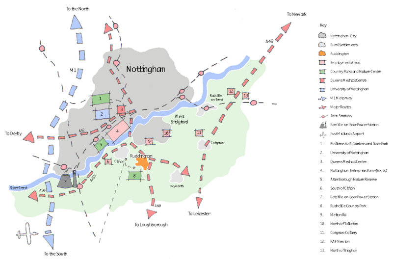
Numbered locations in the map:
- Wollaton Hall
- University of Nottingham
- Queens Medical Centre
- Nottingham Enterprise Zone
- Attenborough Nature Reserve
- South of Clifton
- Ratcliffe on Soar Power Station
- Rushcliffe Country Park
- Melton Road
- North of Tollerton
- Cotgrave Colliery
- RAF Newton
- North of Bingham
Map 3 – Spatial strategy – Parish context
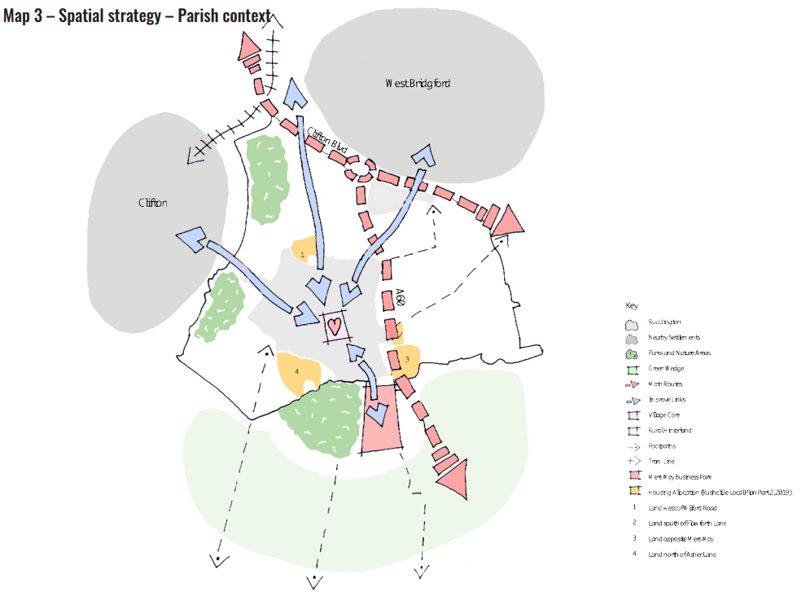
Numbered locations in the map for housing allocations:
- Land west of Wilford Road
- Land south of Flawforth Lane
- Land opposite Mere Way
- Land north of Asher Lane
Parish context (Map 3)
5.9. The village’s context within the parish is set out in Map 3. The surrounding countryside and setting is particularly prized by the community. This is designated Green Belt and its role for leisure and recreation is important for encouraging a better quality of life for residents.
5.10. The Spatial Strategy shows a series of links connecting the village with its surroundings, namely Clifton, West Bridgford and its rural hinterland, via a series of existing paths and links which require improvement.
5.11. Fairham Brook Nature Reserve is within close proximity to the village, due west on the border with Clifton. Rushcliffe Country
Park is located to the south of the village and lies adjacent to Mere Way Business Park, while Wilwell Cutting Nature Reserve lies to the north. The Spatial Strategy emphasises the need for stronger links to connect the village with these assets.
5.12. One important aspect of the Spatial Strategy is the relationship between the village centre and the proposed and existing
development sites on the edge of the settlement. The village centre is the heart of the community, and the creation of sustainable links for walking and cycling to and from the village centre is one of the key elements of the emerging Neighbourhood Plan. The village centre will be the focus for the economic, visitor and leisure facilities.
5.13. Policy 3 of the Rushcliffe Local Plan Core Strategy deals with the spatial strategy for the Borough up to 2028, which is also the
end date for the Ruddington Neighbourhood Plan. Beyond the main built-up area of Nottingham, six “key settlements” are identified for growth, and are expected to accommodate about 5,500 new dwellings. One of these settlements is Ruddington, with its own target of a “minimum” of 250 dwellings.
5.14. Part 2 of the Local Plan, which contains the detailed land and planning policies for the Borough, was adopted after the commencement of work on this neighbourhood plan. Explanatory material at paragraphs 3.76-3.78 says that Ruddington has the
capacity for around 525 new dwellings, and Policies 6.1 to 6.4 allocate four greenfield sites to the north, east and south of the village designed to yield that figure. These sites are land west of Wilford Road, south of Flawforth Lane, opposite Mere Way and north of Asher Lane (see Map 3). All four of the sites now have full planning permission.
5.15. The Ruddington Inset (no.1) in the Local Plan shows the four allocations, together with a modified Green Belt boundary, tightly
drawn around the built-up area of the village (as it is to be extended).
5.16. The context for this neighbourhood plan is therefore that roughly twice as much new housing land has been identified in the village over and above the minimum target set in the Local Plan, and given that this has been adopted relatively recently, there is no
obvious justification for any further housing land allocations within the RNP’s timeframe (ie up to 2028). Development within the
Green Belt is severely restricted, in accordance with Local Plan Policy 21 and section 13 of the NPPF.
5.17. Nevertheless, the Parish and Borough Councils consider it prudent to be in a position to respond to any proposals for housing which do come forward (over and above limited infill, small-scale redevelopment or development which might be considered
acceptable in the Green Belt). In addition, all new planning applications would continue to be assessed on their merits against the development management policies contained within the Local Plan (together with policies in the NPPF, if appropriate), and the RNP’s overall objectives would continue to be a “material consideration” to be taken into account.
Village centre context (Map 4)
5.18. Ruddington’s village centre (as identified on Map 4) forms the heart of the Neighbourhood Plan and the Spatial Strategy seeks
to promote a strong and vibrant village centre. The centre contains most of the village’s shops, offering a wide range of services that are attractive to both residents and shoppers. Key active frontages reside along the village’s main routes, creating a retail core containing a mix of A1 (shops), A3 (food and drink), A4 (drinking establishments) and A5 (hot food takeaways) uses. The Spatial Strategy identifies how appropriate uses should be concentrated within the primary shopping frontage to support a vibrant and active streetscene.
5.19. Consultation revealed that traffic congestion is a major issue in the centre, especially along its key routes. This is exacerbated by
on-street car parking and HGV movement through the village centre. The Neighbourhood Plan seeks to prioritise improvements to pedestrian movement through the village centre and beyond to the wider neighbourhoods of the village. This will aid in encouraging footfall through the village centre, stimulating the local economy.
5.20. Also highlighted on the Spatial Strategy are the village’s valued open spaces and historically significant buildings, including St
Peter’s Church and the Green, attracting visitors from the wider area in to Ruddington. Improving links through the village to the
centre, connecting the village’s key buildings and managing traffic along the key routes are the main issues the emerging neighbourhood Plan seeks to address.
Map 4 – Spatial strategy – Village centre context
6. Policy overview and compliance with objectives
For full Vision and Objective descriptions.
Village Centre Policies
| Policy |
Vision | Village Centre | Housing | Connectivity |
Heritage | Economy | Design and Sustainability |
Environment | Community Infrastructure |
|---|---|---|---|---|---|---|---|---|---|
| Policy 1 Public areas | Yes | Yes | - | Yes | - | Yes | Yes | Yes | Yes |
| Aspiration 1 Public areas | Yes | Yes | - | Yes | - | Yes | Yes | Yes | Yes |
| Policy 2 Acceptable uses in the village centre | Yes | Yes | Yes | Yes | Yes | - | Yes | - | Yes |
| Policy 3 Shop fronts | Yes | Yes | - | - | Yes | Yes | Yes | - | - |
| Aspiration 2 Independent businesses | Yes | Yes | - | - | - | Yes | Yes | - | - |
Housing Policies
| Policy |
Vision | Village Centre | Housing | Connectivity |
Heritage | Economy | Design and Sustainability |
Environment | Community Infrastructure |
|---|---|---|---|---|---|---|---|---|---|
| Policy 4 Custom and self-build | Yes | - | Yes | Yes | - | - | Yes | - | - |
| Aspiration 3 Community right to build | Yes | Yes | Yes | Yes | - | Yes | Yes | Yes | Yes |
Connectivity Policies
| Policy |
Vision | Village Centre | Housing | Connectivity |
Heritage | Economy | Design and Sustainability |
Environment | Community Infrastructure |
|---|---|---|---|---|---|---|---|---|---|
| Policy 5 Pedestrian network | Yes | Yes | - | Yes | - | - | - | - | - |
| Policy 6 Cycle network | Yes | - | - | Yes | - | - | - | - | - |
| Policy 7 Connection to new development | Yes | - | Yes | Yes | - | - | - | - | - |
| Aspiration 4 Safe routes to schools | Yes | Yes | Yes | Yes | - | - | - | - | - |
| Policy 8 Traffic and new development | Yes | - | Yes | Yes | - | - | - | - | - |
| Aspiration 5 Highways measures | Yes | Yes | - | Yes | - | Yes | Yes | - | - |
| Policy 9 Parking | Yes | Yes | Yes | Yes | - | Yes | Yes | - | Yes |
Heritage Policies
| Policy |
Vision | Village Centre | Housing | Connectivity |
Heritage | Economy | Design and Sustainability |
Environment | Community Infrastructure |
|---|---|---|---|---|---|---|---|---|---|
| Policy 10 Conservation area | Yes | - | - | - | Yes | - | Yes | Yes | - |
| Policy 11 Non-designated heritage assets | Yes | Yes | - | - | Yes | Yes | Yes | - | Yes |
| Policy 12 Views, vistas, landmarks and gateways | Yes | - | - | - | Yes | - | Yes | Yes | Yes |
Economy Policies
| Policy |
Vision | Village Centre | Housing | Connectivity |
Heritage | Economy | Design and Sustainability |
Environment | Community Infrastructure |
|---|---|---|---|---|---|---|---|---|---|
| Policy 13 Business Park | Yes | Yes | - | Yes | Yes | Yes | Yes | Yes | Yes |
| Policy 14 Home working | Yes | Yes | Yes | Yes | Yes | Yes | Yes | - | - |
| Policy 15 Digital access | Yes | Yes | - | - | Yes | Yes | - | - | - |
Design and Sustainability Policies
| Policy |
Vision | Village Centre | Housing | Connectivity |
Heritage | Economy | Design and Sustainability |
Environment | Community Infrastructure |
|---|---|---|---|---|---|---|---|---|---|
| Policy 16 Ruddington Design Guide | - | Yes | Yes | Yes | Yes | Yes | Yes | Yes | Yes |
| Policy 17 Sustainable design | - | - | - | - | Yes | - | Yes | - | - |
| Aspiration 6 Future proof design | - | - | - | - | Yes | - | Yes | - | - |
| Policy 18 Landscape in new developments | - | Yes | Yes | - | - | - | Yes | - | - |
| Policy 19 Biodiversity in new developments | - | - | Yes | - | - | - | Yes | Yes | - |
Environment Policies
| Policy |
Vision | Village Centre | Housing | Connectivity |
Heritage | Economy | Design and Sustainability |
Environment | Community Infrastructure |
|---|---|---|---|---|---|---|---|---|---|
| Policy 20 Village setting | Yes | Yes | - | - | - | - | Yes | Yes | - |
| Policy 21 Green infrastructure network | Yes | - | Yes | - | - | - | - | Yes | - |
| Aspiration 7 Management of wildlife and habitats | Yes | - | Yes | - | - | - | - | Yes | - |
Community Infrastructure Policies
| Policy |
Vision | Village Centre | Housing | Connectivity |
Heritage | Economy | Design and Sustainability |
Environment | Community Infrastructure |
|---|---|---|---|---|---|---|---|---|---|
| Policy 22 Community facilities | Yes | Yes | - | - | - | - | - | - | Yes |
| Policy 23 Local green space | Yes | - | Yes | - | - | - | Yes | Yes | Yes |
| Aspiration 8 Accommodating growth | Yes | Yes | Yes | - | - | - | - | - | Yes |
7. Village centre policies
Policy 1 – Public areas
Policy
Development proposals will be supported where they singularly or cumulatively improve the public realm within the village centre, including areas such as The Green. Proposals should purposefully prioritise pedestrians within road and junction layout design using
high quality, robust materials that are sympathetic to the village centre’s historic context. Where it is realistically feasible to do so, these improvements should focus on delivery of the following elements:
- Improved pedestrian infrastructure to create a pedestrian friendly village centre
- Improved integrated parking provision
- Improved accessibility for those with reduced mobility or visual impairment (disabled bays, ramps and additional seating)
- Green infrastructure, including open green space and appropriate planting for aesthetic and environmental benefit.
Schemes within the village centre should, where appropriate, contribute to the improvement of the public realm, including ensuring that pavements and forecourts are reinstated to a high quality in line with the criteria set out above. Schemes in the village centre that seek to provide improved spaces suitable for events and village activities will be supported.
In order to gain understanding of local context, developers should refer to Part 1 of the Ruddington Design Guide which sets out the context for the Village’s 21 character areas.
Justification
7.1.This policy seeks to improve public areas around the village centre, including the preparation of a strategy for the village centre as a
whole. It focuses on improving existing streets, pavements and spaces and promotes improvements to street furniture and signage. In addition, it promotes greater use of planting and green infrastructure in the village centre.
Evidence base
Ruddington Design Guide - Appendix 6, 7 and 8
Aspiration 1 – Public Areas
Aspiration
The Parish Council will work with partners to arrive at a strategy for the village centre that: improves and reduces street signage; incorporates improvements for all transport modes, with priority to non-vehicular modes of transport (walking and cycling) and public transport; and delivers appropriate parking provision. This strategy will also facilitate the regeneration at the corner of the High Street
and the Green, and the Community Centre.
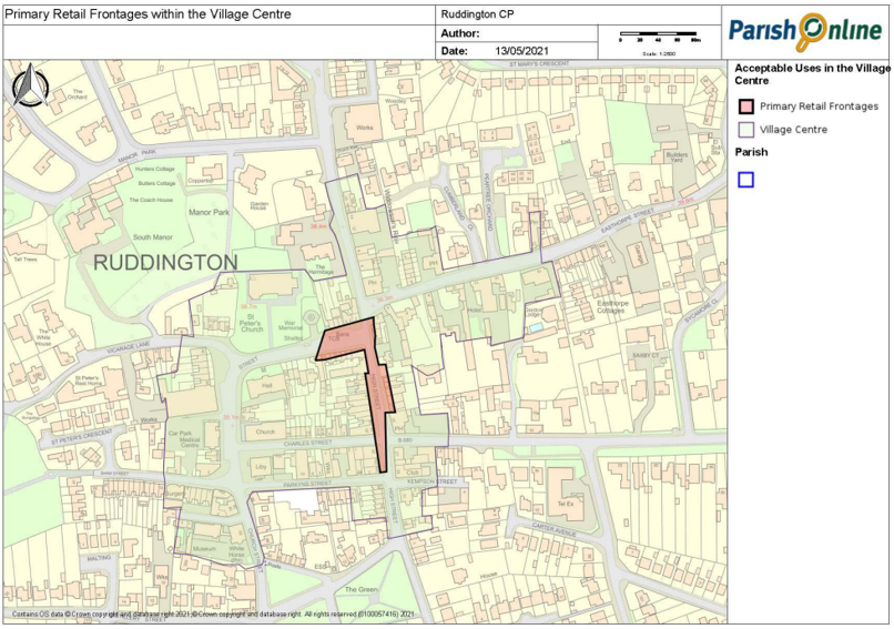
Policy 2 – Acceptable uses in the village centre
Policy
Within the Primary Retail Frontages, as defined on Map 5, where planning permission is required, applications for retail development at ground floor level within class E will be supported. Where planning permission is required, applications for other forms of development at ground floor level must comply with District and Local Centre policies within the Rushcliffe Local Plan.
The design of retail frontages should comply with the Ruddington Design Guide and Policy 5 - Shop fronts. Where planning permission is required, applications within the village centre boundary but outside of these primary shopping frontages for non-retail uses at ground floor level will be supported where they can demonstrate enhancement of the vitality of the village centre. These include residential, entertainment, cultural, leisure and community uses, such as spaces for youth groups or for community learning.
Justification
7.2. The aim of this policy is to ensure that within the village centre, retail and community uses are promoted and protected. The aim is to ensure a concentration of business in the village centre. Maintaining the cluster of retail uses should result in fewer empty units. The
conversion of retail to other commercial uses within the same Use Class however does not require planning permission (in addition to retail Use Class E comprises financial services, cafes and restaurants, offices, research and development, and industrial processes). Where planning permission is required, the conversion of ground floor retail units to non-retail uses within the primary shopping frontages should accord with the Rushcliffe Local Plan, including Policy 25. This allows for a limited number of non-retail uses within the primary retail frontage. Across the village centre, including land outside the primary retail frontage, it is also essential to bring vacant properties back into community or commercial use as they have an adverse effect on the visual amenity and commercial viability.
Policy 3 – Shop fronts
Policy
Where planning permission is required for the refurbishment or replacement of existing shop frontages and the installation of new shop fronts, applicants must demonstrate how they have considered and addressed the following design criteria:
- Consideration of the architectural styles of adjoining buildings and shop fronts and the wider street scene, including where appropriate, contemporary design
- Fascias should be of a scale proportionate to the rest of the building; they should not obscure windows and other architectural detailing; they should align with other fascias in the parade. Box fascias and box lighting will not be permitted.
- The subdivision and proportions of windows should relate to the character of the building and its neighbours
- Signage should respect the character of the individual building and adjoining properties.
- Solid shutters will not be supported. Security measures should maintain a level of transparency to and from the street, such as laminated glazing, lattice grilles and perforated shutters.
- Projecting boxes and external shutters are also considered to be inappropriate and will be resisted.
Further detail on the design of shop fronts is provided in Part 2 of the Ruddington Design Guide.
Justification
7.3. This policy sets out criteria for how new shop frontages should be designed. It includes details of proportion, glazing and street displays as well as how the frontage will be secured when the premises are closed.
7.4. The village centre has special heritage and conservation value, recognised by its status as a conservation area and its listed buildings. The design of shop frontages should make a positive contribution to the sense of place and local character and be in line with the Ruddington Design Guide and Conservation Area Appraisal.
Evidence base
- Ruddington Design Guide - Appendix 6, 7 and 8
- Ruddington Conservation Area Appraisal and Management Plan
Aspiration 2 – Independent businesses
Aspiration
The Parish Council strongly supports the role of new and existing independent business within the village and will work with local
business owners to continue to devise campaigns, events and activities that promote locally owned businesses.
Justification
7.5. This aspiration sets out the Parish Council’s commitment to encouraging independent businesses in Ruddington. Schemes to encourage the use of local and independent business form a crucial element of the Parish Council’s plan for the village. Such schemes however, fall outside the planning system and so are included under this aspiration.
Map 5 – Acceptable uses in the village centre
8. Housing policies
Policy 4 – Custom and self-build
Policy
Applications seeking to deliver custom or self-build residential properties will be supported in principle by the Neighbourhood Plan. Proposals seeking custom or self-build projects should demonstrate that they have been informed by the Rushcliffe Borough Council’s self and custom build register. Custom and self-build projects seeking to deliver dwellings of a type and scale that reflect and complement existing character will be encouraged.
All custom or self-build development proposals should take into consideration the criteria set out in the Ruddington Design Guide
and demonstrate how they meet the guidance within other design-based policies set out within this Neighbourhood Plan. Where appropriate, all proposed developments must supply sufficient parking provision in accordance with Policy 12 - Parking and servicing, of the Neighbourhood Plan.
Justification
8.1. In accordance with the Self and Custom Housebuilding Act (2015), Rushcliffe Borough Council maintains a register of those seeking to acquire land to build their own homes. This provides evidence of demand within the Borough. The Council must have regard to the register when carrying out planning, housing, disposal of land and regeneration functions. Within Ruddington, this evidence should be used to inform the development of self or custom build plots.
8.2. The community have expressed that all residential development, including custom or self-build plots, should seek to deliver proposals that reflect the local character and meet the requirements within the design policies in this Neighbourhood Plan.
Aspiration 3 – Community right to build order
Aspiration
Ruddington Parish Council will work with local community organisations to bring forward a ‘community right to build order’ in order to deliver specific types of development identified by the community such as new homes, shops, businesses, community facilities or playgrounds, which comply with the order. The Parish Council will lead such projects and seek to work with the Borough Council to utilise the ‘community right to build order’ and incorporate it into the Neighbourhood Plan.
Justification
8.3. The Localism Act allows for community organisation to bring forward a ‘community right to build order’, which is a type of neighbourhood development order. This will allow members of the community to bring forward smaller-scale development on a specific site, without the need for planning permission. This gives communities the freedom to develop, for instance, small-scale housing, and other facilities that they want as a Parish Council led project.
8.4. Any benefit from this development stays within the community to be used for the community's benefit, for example, to maintain affordable housing stock or to provide and maintain local facilities such as playgrounds and village halls.
9. Connectivity policies
Policy 5 – Pedestrian network
Policy
Where appropriate new development, excluding householder planning applications, should be supported where they contribute to the creation of a network of safe and well-surfaced footpaths. Developments that would reduce or undermine the network through the stopping up or diversion of footpaths, public rights of way or permissive routes, without acceptable alternative routes being provided, will not be supported.
All new routes should be designed with safety in mind and should, where appropriate, be well overlooked to ensure they benefit
from passive surveillance.
Developments that include new footpaths, streets or spaces, or improved or new links to the wider public footpath network and
which are designed to cater for a wide range of ages and abilities will be supported. Developments that enhance a footpath, public
right of way or permissive route to ensure access for a wider range of ages and abilities will also be supported.
Developments on larger sites (greater than 50 units, or 1,000 square metres of commercial space) must ensure continuous pedestrian routes are provided between the development site and residential areas, local shops, services, and facilities.
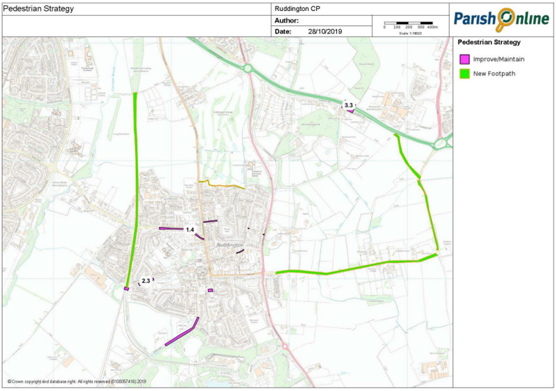
Development that contributes towards the provision and enhancement of the links within the village, wider area and whole parish, specified in the Ruddington Pedestrian Strategy Core Document 11, will be supported.
Justification
9.1. Planning applications are required by this policy to invest in public footpaths and pavements. This can be by simply ensuring that a new access point is reinstated appropriately, or by delivering new links within new development sites both on and off site. Schemes should use, upgrade, and connect, where possible, the existing network of public rights of way and permissive routes. The pedestrian strategy referred to in Policy 5 was produced by the Parish Council. It supports the Neighbourhood Plan, identifying pedestrian
infrastructure projects which the Parish Council believe are necessary to improve pedestrian accessibility within the plan area. These are shown within Map 6.
9.2. It is important that in designing new pedestrian routes, applicants take into account a wide range of users, including but not limited to the elderly, those with disabilities and those with young children. The policy also requires that routes are well overlooked, which means that they should be in front of homes, shops, and offices rather than as alleys. Alleys are narrow and unattractive to walk along, especially after dark.
Evidence base
Ruddington Pedestrian strategy v3 (Core document 11)
Map 6 – Ruddington Pedestrian Strategy
Policy 6 – Cycle network
Policy
Where appropriate, new development, excluding householder planning applications, will be required to demonstrate how it will seek to support cycling within the village for all ages and abilities. For residential development, cycle parking spaces should be under cover and secure. For developments with common facilities, such as flats, one space should be provided for every five dwellings. For individual dwellings, one space should be provided per dwelling.
The design of all streets and spaces within developments should be cycle friendly and provide connections to the main shops, services and facilities. A cycle strategy has been prepared to guide the implementation of this policy and identifies key cycle routes for creation and improvement as part of a wider network, which should include segregated, continuous cycle routes. Applicants will be required to demonstrate how they have contributed to these elements, where relevant, and have provided cycle infrastructure such as cycle storage.
Justification
9.3. Planning applications, are required by this policy to invest in the cycle network and supporting infrastructure. Schemes should use, upgrade, and connect where possible, the existing network. The cycle strategy referred to in Policy 6 was produced by the Parish
Council. It supports the Neighbourhood Plan, identifying a number of objectives that improve the quantity and quality of cycle routes and infrastructure. It also includes specific proposals which the Parish Council believe are necessary to increase cycling within the plan area.
9.4. All developments can support cycling through the provision of secure cycle parking, whilst larger developments (greater than 50 homes or 1,000 square metres) should provide more substantial infrastructure including new cycle routes or highways designed to be
cycle friendly.
Evidence base
- Cycle Strategy (Core Document 3)
Policy 7 – Connection to new development
Policy
All major residential, employment, retail, leisure and recreational or community developments should demonstrate how residents or users will access key village services, facilities and public transport services via existing routes. Where existing routes do not provide adequate access, these developments should either enhance or create new routes. Contributions will be sought to ensure these routes are provided to serve new development.
Justification
9.5. Where new development results in increased demand for services and facilities or provides a facility that existing residents wish to use, measures should be taken to encourage access via sustainable modes of transport. The key aim is to discourage use of the private vehicle and to encourage increased physical activity and use of public transport. Contributions will be sought from new development, where appropriate, to ensure routes are of a high quality and provide useable, safe routes for a range of users and modes.
Aspiration 4 – Safe routes to schools
Aspiration
Applications for all major developments (greater than 50 homes or 1,000 square metres) should demonstrate how they can ensure
appropriate access to schools via safe and well-lit sustainable transport routes, such as for walking and cycling. Contributions may be sought to achieve this. Such routes should also join to existing footpaths, bridleways and permissive routes in the village and where possible, existing footpaths, bridleways and permissive routes will be upgraded to facilitate these school routes.
Where appropriate, applications for new and expanded educational buildings should include facilities for cycling and changing and will be required to prepare a travel plan demonstrating how they will encourage access by cycling and walking with reference to the Ruddington Pedestrian and Cycle Strategies (Core Documents 3 and 11).
Justification
9.6. Congestion around schools at the start and end of the school day has been recognised as a concern by residents. This aspiration requires that major developments demonstrate how they have considered this matter.
9.7. School developments will be encouraged to look at a variety of measures to mitigate the above identified issues, which would include the following:
- Encouraging users to walk or use bicycles
- Providing school buses or walking buses
- Providing more onsite parking and waiting space
- Changing the pattern of the school day to reduce peak congestion.
Evidence base
- Cycle Strategy (Core Document 3)
- Ruddington Pedestrian strategy v3 (Core document 11)
Policy 8 – Traffic and new development
Policy
All developments, where relevant, will be required to demonstrate how they have ensured they can be accessed via sustainable
transport modes (walking, cycling and bus) for all ages and abilities.
All development proposals, regardless of scale should demonstrate, where appropriate, that they have:
- Integrated the proposed development seamlessly into the existing walking and cycling routes or created new connections
where this is required or desirable, to encourage active travel - Provided safe cycle storage as an integral part of the proposed development, including appropriate changing and showering
facilities where appropriate - Sited the proposed development to take advantage of public transport facilities within the village.
All new developments, which would increase demand for car parking, should ensure that they provide appropriate facilities for electric vehicles, including the provision of charging points. Development which supports or proposes community transport or shared transport options will be strongly supported.
Justification
9.8. The community has identified that traffic and congestion within the village is a key issue that ought to be addressed. Every effort needs to be made to challenge the use of the private car and make it more attractive to use the sustainable transport modes.
9.9. This policy affects all developments, regardless of type, and ensures that they are sustainably located and maximise the opportunities to connect to walking, cycling and public transport networks.
9.10. This will not only address a desire for a reduction in vehicle movements but will target the overall environmental goals, reducing pollution from private vehicles, and assisting health and wellbeing by encouraging active travel.
Aspiration 5 – Highways measures
Aspiration
The impact of traffic through the village is an issue that needs to be carefully managed and monitored. The Parish Council and other community organisations are committed to working with the highways authority to monitor traffic travelling through the village in order to design and develop solutions. Parking enforcement, parking schemes and one way systems may be explored as part of this strategy.
Justification
9.11. This aspiration sets out the Parish Council’s aim to assess the impact of parking and traffic on the village and work with relevant partners and stakeholders to put measures in place to address matters such as parking and traffic flow. Whilst the neighbourhood plan seeks to encourage reduced use of private vehicles, it is recognised that some people do need to drive.
9.12. This may involve the adoption of measures such as a one-way system, parking, weight and speed restrictions and pedestrian facilities. The steering group has consulted on these matters and has prepared a document that sets out key aims and aspirations for these interlinked issues.
Policy 9 – Parking
Policy
Applications will be expected to demonstrate how they have met the following design criteria for parking spaces:
- All parking will, wherever possible, be on plot, without impacting or protruding onto surrounding streets and pavements
- Schemes should provide sufficient parking, in line with the highways authority standards
- Parking spaces should measure a minimum of 2.4 m x 5.5 m with 0.5 m added to the width if the space is adjacent to a boundary (1 m to be added if the space is bounded on both sides)
- Garages will not be counted towards parking provision unless it can be demonstrated that they are sufficient in size in line with guidance
- Tandem parking should be avoided where alternative solutions are available.
Justification
9.13. Dependency on the private car is an ever-increasing issue. This is particularly relevant in residential and retail areas, where on-street parking can lead to traffic congestion. This issue has been highlighted by residents in consultation events.
9.14. This policy seeks to ensure that where new parking is provided, it is of sufficient size to fit a modern car and is on-plot to avoid pressure on existing streets. It also seeks to avoid the construction of garages counted towards parking provision but are too small or never used by occupants. Nottinghamshire County Council is the Highways Authority within Ruddington, they have published parking standards alongside other highways standards within the Highway Design Guide. The Highways Design Guide alongside national standards such as the Manual for Streets and Design Manual for Roads and Bridges are important material considerations when assessing the highways and parking implications of planning applications.”
10. Heritage policies
Policy 10 – Conservation area
Policy
Applications within or adjacent to the Conservation Area will be supported in principle only where they preserve or enhance its character or appearance and its heritage assets and follow the guidance stated within the Conservation Area Appraisal Management Plan, which includes the following considerations:
- building design
- boundary treatment
- landscaping
- materials
- street furniture
- signage
Schemes will be required to demonstrate that they have had regard to relevant guidance contained within the CAAMP and the Ruddington Design Guide.
Justification
10.1. Ruddington benefits from a number of historic buildings, spaces, street patterns, and architectural detailing, which together
contribute to the village’s local character. This policy supports the approach to protecting heritage assets and their setting, as set out
under chapter 16 of the NPPF, and policy 11 of the Rushcliffe Local Plan Part One.
10.2. At consultation, residents highlighted that the protection and enhancement of the Conservation Area should be a priority and
that proposals must be of high quality design to ensure the development makes a positive contribution to the special character of
the Conservation Area.
10.3. The Neighbourhood Plan will look favourably on new developments and alterations to existing properties that utilise good design and contribute to the protection and enhancement of the special character of the Parish. The Ruddington CAAMP and the Ruddington Design Guide are key documents that provide guidance for new developments (including alterations and extensions) on sites within, or adjacent to the Conservation Area. The Ruddington CAAMP was produced by Rushcliffe Borough Council (CAAMPs have been produced for all conservation areas in the Borough). It identifies key conservation area characteristics and issues, important buildings, different character areas, and management proposals. The CAAMP is a material consideration that informs decisions on a development’s impacts on the conservation area and its compliance with policies that seek to preserve and enhance them. The Ruddington Design Guide has
been produced by Ruddington Parish (Policy 17 and it supporting justification explains the content and status of this guide).
Policy 11 – Non-designated heritage assets
Policy
Planning applications must take into account the impact of development on non-designated heritage assets in the village, seeking to protect and, where appropriate, enhance them. Proposals must demonstrate that they have considered guidance for proposals affecting non-designated assets and consulted the Conservation Area Appraisal Management Plan and the Ruddington Design Guide.
Justification
10.4. This policy supports the approach to protecting non-designated heritage assets and their setting, as set out under chapter 16 of the NPPF, and policy 11 of the Rushcliffe Local Plan Part One. The buildings listed in Appendix 1 have been identified by the Parish Council as buildings of local importance. These heritage assets help to define the village’s character and portray much of its history.
10.5. It is important that non-designated heritage assets are accounted for and covered within this policy as their value to the community is significant.
Policy 12 – Views, vistas, landmarks and gateways
Policy
All new development should, where relevant, demonstrate how it protects and enhances key views, vistas, landmarks, and gateways, identified within the Ruddington Design Guide, through meeting the following criteria:
- Views and vistas should be protected from inappropriate development and landscape planting. The closing of views due to excessive scale, or mass, and planting of inappropriate species is to be avoided. Development that uses planting and buildings to frame key views will be looked on favourably.
- The loss of landmark structures will be strongly resisted in accordance with Policy - 13 Conservation area and Policy 14 - Non-designated heritage assets.
- Planning applications that adversely affect a gateway into the village will not be supported. In some instances, it may be appropriate to extend or create a new gateway into the village.
In all cases, applicants must demonstrate how they meet the requirements set out in the Ruddington Design Guide and demonstrate how they meet the guidance within other design-based policies set out within this Neighbourhood Plan. Furthermore, where appropriate, all proposed developments must supply sufficient parking provision in accordance with Policy 12 - Parking and servicing.
Justification
10.6. This policy recognises the important contribution that landmarks, views, vistas, and gateways make to the character of the village. These have been identified within the Ruddington Design Guide and are shown within Map 7. Development will be required to respond to these identified features through their building and landscape design. These features are important to the setting and character of Ruddington, its Conservation Area, and its overall landscape setting and are strongly valued by the community, as demonstrated during consultation. Landmarks and gateways that help with local wayfinding and give a sense of arrival in the village and should be carefully considered.
Map 7 – Key views, vistas, landmarks and gateways within the Ruddington Design Guide
11. Economy policies
Policy 13 – Business Park
Policy
New employment development (Use classes B1 and B2) will be permitted within the existing Mere Way Business Park where it relates to the replacement or enhancement of the accommodation. New specialist engineering, research, and development uses will be supported. The loss of employment uses will be resisted.
All new development should meet the following criteria:
- The site provides and retains sufficient parking in line with the guidance within the Local Plan, avoiding impermeable surfaces and integrating sustainable drainage.
- New development is well integrated within the existing landscape and planting in the area – specifically the adjacent country park – preserving mature vegetation where possible.
- Traffic is managed, where appropriate, through the use of a travel plan which includes, but is not limited to, HGV routing
and employee travel to work as well as regular review mechanisms. - Contributes, where appropriate, to increased provision of pedestrian and cycle links between the village core and the business park.
- Make reasonable effort to incorporate renewable energy generation such as solar panels, micro wind turbines and grey water recycling.
Justification
11.1. Mere Way Business Park, adjacent to the country park is an existing employment asset providing jobs for the local area and further afield. Currently it is occupied by a range of office based, research, development, and industrial uses, across a series of units that are between 10 and 20 years old.
11.2. Whilst this policy does not promote an increase in size, it acknowledges that businesses may change and grow at Mere Way Business Park over the plan period and therefore there will likely be planning applications for either the extension of premises and/or replacement buildings.
11.3. Consultation on this policy revealed that whilst economic growth was supported by the community, this should not be at the expense of residential amenity or the environment. As a result, and based on the matters raised by the community, a series of clear criteria have been included to manage this development within the Neighbourhood Plan. Whilst much of this is covered in part by the Rushcliffe Borough Local Plan, the specific relationship of the business park to both the village centre and the country park require detailed policy consideration, which is provided by this policy.
Policy 14 – Home working
Policy
Where planning permission is required for ancillary employment uses as part of dwelling houses (including separate office or workshop space within the residential curtilage), permission will be granted where the proposal meets the following criteria:
- The use is commensurate with a residential area and will not negatively impact on residential amenity through noise, vibration, fumes, smells or other emissions
- The use does not impact negatively on the visual character or amenity of the area, through large areas of external hard standing, parking or storage
- The use does not rely on regular additional staff members or clients/customers visiting the site on a day-to-day basis without provision of appropriate on-site parking
- The use does not intensify the vehicular comings and goings from the residential property as a result of visitors/staff, deliveries or other servicing requirements.
Justification
11.4. Home working is becoming an ever-increasing reality in the 21st century. With advancements in communications and technology it is becoming increasingly common that people work from home and run businesses online. The Neighbourhood Plan wishes to support
this, ensuring that economic growth and diversity can happen throughout the parish at all levels. In most cases this is acceptable, but where the intensity or scale of development increases, this becomes an issue for residential amenity and quality of life.
11.5. Planning permission is not necessarily needed to provide accommodation for working from home. The key test is whether the overall character of the dwelling will change as a result of the business, something which it would be for the Borough Council to decide in each case.
11.6. Based on the feedback from the community and considering the key tests for employment set by national guidance and Local Plan policy, the policy sets out four tests to determine the acceptability of employment uses in a residential area associated with home
working. It also introduces an important requirement for adaptability of rooms within a new dwelling to be able to accommodate home
office requirements, which will allow new homes to benefit and encourage home working and the benefits that provides.
Policy 15 – Digital access
Policy
High capacity and high speed digital communication networks (including broadband, mobile telephone and the most up to date
connectivity) will be supported throughout Ruddington to meet the needs of businesses and local people, subject to ensuring radio and telecommunications infrastructure is appropriately located and the number of masts minimised to ensure the efficient operation of the network.
Developers will be required to work with appropriate providers to deliver the necessary physical infrastructure to accommodate
information and digital communications (ICT) networks as an integral part of all appropriate new developments. Where technically feasible, conditions will be imposed to ensure broadband connection can be achieved prior to occupation of new developments.
Justification
11.7. Throughout the various consultations of this plan, the matter of digital communication was considered important to the overall success and wellbeing of the parish. Many respondents commented on the poor mobile reception in the village centre and the lack of
broadband connectivity in the Parish as a whole. In many cases, the infrastructure required to deliver such improvements requires planning permission, and this policy sets out a general encouragement for this type of development, subject to it being appropriately located.
11.8. The second part of the policy ensures that new development is connected to high speed broadband. The introduction of a 5G broadband connection will require the Parish Council to review and update this policy in advance of a complete review of the Neighbourhood Plan.
12. Design and sustainability policies
Policy 16 – Ruddington Design Guide
Policy
All development, regardless of size or type, will be supported in principle where it demonstrates how it has contributed towards
delivering contextually responsive design, as outlined within the Ruddington Design Guide, an appendix to this Neighbourhood Plan. The Ruddington Design Guide has been completed in consultation with the local community and in accordance with the National Design Guide. Applicants will be expected to have regard relevant parts of the Ruddington Design Guide and if a different design approach has been taken justify this as part of their planning submissions (usually within a Design and Access Statement) why they have taken a different design approach. The Ruddington Design Guide does not seek to stifle innovative or contemporary design, which will be supported where delivered to a high standard. Development proposals of all sizes should ensure that they respect the local character in terms of density, scale, and mass, materials and landscape, and boundary treatments. Major developments, which are submitted for outline permission, will be expected to develop design codes and detailed parameters to help meet high quality design required by the Ruddington Design Guide parts 1 and 3. Such codes and guides will be conditioned where appropriate to ensure high design standards.
Applicants should seek to integrate sustainable design features into any proposed development, in accordance with Policy 20 -
Sustainable design.
Justification
12.1. National planning policy sets out that design quality is an important element of achieving sustainable development, and that neighbourhood plans have a vital role to play in setting out the important qualities of a local area and how they should be reflected in new development. In support of the Framework, a National Design Guide was published September 19 with the purpose of aiding local planning authorities and councillors in their decision making, helping applicants to prepare planning applications and people in local communities to make representations. As part of this push for greater consideration of good design, the Ruddington Design Guide has been prepared, coupled with its supporting character study. The Ruddington Design Guide sets out a series of design considerations
for developments both within the existing built up area (including the conservation area) and also for the larger allocated sites within Local Plan Part Two prepared by Rushcliffe Borough Council.
12.2. The character assessment and the Ruddington Design Guide support this Neighbourhood Plan and the operation of this policy. It has considered independent assessments of character undertaken by the supporting consultants and the conservation officer (as part of the conservation area appraisal). Work associated with the Ruddington Design Guide has included a series of community walkovers (summer 2019) to determine what the people of Ruddington truly value about their environment.
12.3. This policy sets out that major developments, which are commonly delivered through the two stage process of outline planning applications followed by more detailed reserved matters applications, will be expected to be supported by a series of detailed site parameters and codes to ensure that design quality remains at the heart of the planning process. So often, larger schemes result in a
‘dumbing-down’ of design quality between outline and detailed design stages as sites change ownership and consultants. By conditioning these elements as part of any outline approval, the design qualities are secured during the detailed design stage.
Policy 17 – Sustainable design
Policy
All new development (excepting householder applications) should demonstrate how it has met, and where possible exceeded, the
minimum standards for energy efficiency and construction quality. Applicants should demonstrate how they have embraced and where possible delivered, the following features as part of their applications:
- The use of innovative design techniques that reduce the demand for energy, including, but not limited to, the incorporation of passive solar gain, passive cooling and ventilation, heat pumps and neutral design
- The use of on-site energy generation technologies to reduce the demand for energy
- Where appropriate, the inclusion of electric vehicle charging points.
- Technologies which minimise the use of water
- The end of life plan for the building including the ability to recycle materials used
Justification
12.4. Policy 2 within the Rushcliffe Local Plan Part 1 Core Strategy outlines borough wide sustainable design considerations and requirements. The design of our buildings and spaces can have a very important role to play in mitigating the effects of climate change and addressing wider sustainability goals such as managing energy and other resources. This policy is developed based on guidance and research from the UK Green Building Council and their work with the housebuilders and policy makers in the UK to create policies that will drive improvements in sustainable design. The government has set a target to reduce greenhouse gas emissions to net zero by 2050 (Climate Change Act 2008). In response Rushcliffe Council have declared a climate emergency placing matters of climate change higher up the local agenda. This involves setting carbon neutral targets and widespread carbon reductions across the borough. This policy provides a response at the village level to that declaration and seeks to contribute towards the Borough Council and government’s work to encourage local action against climate change.
12.5. The policy, based on the guidance (that includes policies from elsewhere in the UK), is designed to set higher standards for sustainable design and construction. The policy seeks to ensure that sustainable design is considered for the lifetime of the building and a 'cradle to grave' approach is taken when making decisions about the use of materials and technologies.
Aspiration 6 – Future proof design
Aspiration
The Neighbourhood Plan seeks to encourage future proof and
sustainable design for developments of all scales and uses.
Projects which promote the following methods, technologies and
practices will be strongly supported:
- The use of sustainably sourced and energy efficient materials as part of the building’s construction, which seek to reduce the overall carbon footprint of the building
- The siting and orientation of buildings and spaces for passive solar gain
- The use of thermally efficient, durable, recyclable and environmentally sustainable building materials
- The avoidance of mains gas connection, to prevent the use of non-renewable fossil fuels by new properties for heating
- The reduction of water usage through use of water saving technologies, for example, bubble taps, grey water usage and rainwater harvesting
- The retrofitting of historic and older buildings to improve energy efficiency (whilst protecting their historic significance)
- The incorporation of green roofs, walls and street trees into the fabric of the village
- Community owned or led renewable energy production
- Connection to a district heating system if available in the future
All schemes should demonstrate how they are appropriate and sensitive to the local character and appearance of the village with
reference to the Ruddington Design Guide.
Justification
12.6. Some elements of the village’s vision for sustainable design fall outside the remit of neighbourhood planning and so this aspiration seeks to encourage those proposing development to consider a range of factors which will help limit environmental impact. A number of techniques are suggested however, this is not an exhaustive list. Projects which seek to limit energy use and promote renewable
energy production in innovative and sensitive ways are strongly encouraged and welcomed within the village.
Policy 18 – Landscape in new developments
Policy
Where its character and scale realistically permit, new developments should seek to enhance the contribution that the site can make to the wider green and blue infrastructure network (see Policy 24 - Green infrastructure network). In doing so, they should seek to provide high quality external spaces and features, based around the following key principles:
- Avoid the loss of mature trees, hedgerows, and other planted features, or mitigate for any unavoidable loss through replacement
planting of a mixture of native species and types. - Avoid hard features as part of boundary treatments, where this is practicable, in favour of natural planted features, including hedges (in line with guidance in Policy 22 - Biodiversity in new developments)
- Ensure green infrastructure is integral in the design of the buildings, in the form of green roofs, green walls and appropriate private gardens and semi-private amenity spaces.
- Integrate the provision of sustainable urban drainage as part of hard surfacing to reduce surface run-off, seeking to ensure that surface run-off is managed within the boundary of the application site.
- Where appropriate, provision or enhancement of blue and green corridors should be considered. Where a householder application is submitted, applicants should be expected as a minimum to demonstrate how they have retained and/or enhanced the green landscaped features and ensured that all surface water drainage is sustainably managed within the property boundary.
Justification
12.7. New developments, especially those on larger sites, have an important role to play in improving preserving and enhancing the environmental qualities of the parish. The national planning policy guidance and design guidance identify the importance of networks of habitats and biodiversity, which have been studied as part of the evidence behind this plan (see policy 24 - Green infrastructure
network). In order to do this, the qualities of the external environments – gardens, spaces, boundary treatments, parking areas – are all important elements in achieving the overarching goals.
12.8. Planning applications, regardless of scale or type, are required to include detailed landscape proposals (where as part of the application or via condition that must be discharged), and details of how existing trees, hedgerows and other natural elements on the
site will be protected and enhanced. This policy is simply designed to provide guidance as to how such details should be considered, based on best practice design considerations and feedback from the community.
12.9. The criteria included in this policy focus on four ways in which the careful design of the exterior spaces of a building can help achieve sustainable design, supporting biodiversity, wildlife, and overall quality of life for those who use them.
Policy 19 – Biodiversity in new developments
Policy
Where its character and scale realistically permit, new development should seek to provide net gain for local biodiversity and human health and wellbeing. Net gain in biodiversity should be demonstrated through the use of appropriate evaluation and delivery methodologies. Compensation through biodiversity off-setting will be sought where there is an unavoidable net loss of biodiversity.
Where appropriate, all new proposals should address the following six points though their landscape design and planting proposals;
- Inclusion of native (or native hybrid) species as part of planting schemes including, where appropriate species that offer nectar, fruit or berries for wildlife. Where native species cannot be used justification for use of non-native alternatives will be required.
- Inclusion of new habitats or facilities for amphibians and insects, including, where appropriate, unmanaged areas of native grassland and planting and open water features and marginal water habitats Inclusion of plants and planting suitable for encouraging butterflies, bees and other pollinating insects, especially species to support insects all year round.
- Inclusion of bird and bat boxes for a variety of species, beyond any mitigation requirements.
- Inclusion of ‘hedgehog holes’ in fences, to allow hedgehogs to travel between gardens.
- Inclusion of sufficient soil depth in garden areas for the growing of a variety of plants and shrubs, including the growing of vegetables.
Justification
12.10. National policy is keen to ensure that new developments deliver biodiversity net gain. In reality. This means that new development should take every opportunity to improve opportunities for wildlife and habitats when they are developed. This policy, tying into Local Plan policies at the Borough level, sets out a series of design criteria that can collectively help to deliver this net gain.
12.11. The choice of species and the landscape proposals delivered for any site can operate at a number of scales from the smallest residential extension, where new hedgerows and bird boxes can work, right up to larger strategic schemes, where new planted features and unmanaged habitats can also be introduced as part of the network of green and blue spaces. Guidance and best practise examples
available from the Construction Industry Research and Information Association (CIRIA) recommend how sustainable urban drainage systems (SuDS) can be designed to maximise the potential for wildlife (CIRIA C753 The SuDS Manual).
13. Environment policies
Policy 20 – Village setting
Policy
Applications that affect the visual amenity of the main gateways or the settlement edge of Ruddington should follow guidance provided
within the Ruddington Design Guide (parts 1, 2 and 3) and Policy 19 Ruddington Design Guide, Policy 21 - Landscape in new
developments and Policy 22 - Biodiversity in new developments. Development proposals at the settlement edge must demonstrate
how their design takes into account the rural setting and character and provides a positive transition between the built form and the
wider landscape. In all cases development proposals should be well landscaped with native species, developed to a lower density and
should not create a townscape that ‘backs onto’ the landscape. Applications beyond the settlement should seek to reflect guidance
within the Nottinghamshire Landscape Character Assessment (2009) (or any subsequent replacement document), and ensure they
address the following principles:
- To the north and east of the parish, applications should recognise and respond to the important mature landscape character, and seek to restore and enhance the landscape patterns of this area.
- To the south and west of the parish, applications should recognise the importance of the pattern of woodlands and wetlands associated with the Fairham Brook.
Justification
13.1. Green infrastructure refers to features such as trees, hedgerows, woodlands and other natural planted features or habitats. Blue infrastructure refers to waterbodies and watercourses. Collectively these features combine to form a network of nature features
known as the green and blue infrastructure network and act as important wildlife and biodiversity corridors.
13.2. The 2018 Green Infrastructure Background Paper (Rushcliffe Borough Council) identifies Ruddington as sitting within the urban fringe landscape environment around Greater Nottingham. This means that there is an important relationship between the built form (the villages, settlements, and urban area) and the wider landscape that needs to be carefully managed.
13.3. Land beyond the village boundary is within the Green Belt (Ruddington is inset from the Green Belt), and in accordance with the Rushcliffe Local Plan, planning applications submitted within the Green Belt must comply with national Green Belt policy in the National Planning Policy Framework. National policy identifies circumstances where built development is appropriate (such as agricultural
buildings, outdoor sports and recreation, replacement of existing buildings, and affordable housing to meet local community needs). Other developments (such as open market housing or employment) are inappropriate development and can only be permitted in very special circumstances. These circumstances will not exist unless the harm to the Green Belt (which is given substantial weight) and
any other harm is outweighed by other considerations. The four housing sites on the edge of Ruddington which are identified in the Rushcliffe Local Plan were removed from the Green Belt when the plan was adopted. The Green Belt inset boundary was extended to include these allocated housing sites within the village.
13.4. The four housing sites on the edge of Ruddington which are identified in the Rushcliffe Local Plan were removed from the Green Belt when the plan was adopted. The Green Belt inset boundary was extended to include these allocated housing sites within the
village.
13.5. The 2009 Landscape Character Assessment (Nottinghamshire County Council/The Environment Partnership) further identifies that there are two important landscape characters surrounding Ruddington, including a mature landscape to the north and east that should be preserved and enhanced wherever possible through careful management and development. It also identifies an important landscape of woodlands and wetlands alongside Fairham Brook and its tributaries which criss-cross Ruddington Moor to the south and west.
Policy 21 – Green infrastructure network
Policy
All planning applications, except householder applications, will be supported where they demonstrate, as part of detailed landscape
schemes (or strategies if an outline proposal), that they have preserved or enhanced the network of blue and green infrastructure within Ruddington as set out in appendix 3. Schemes that would result in the loss of any features which make a significant contribution to elements of the green or blue infrastructure network will normally be refused planning permission.
Despite being outside the Parish, proposals within Ruddington Parish that are likely to adversely affect the Fairham Brook or its setting should reflect its importance as a significant piece of blue and green infrastructure. Proposals to the south and west of the parish should seek to enhance its role through appropriate landscape design.
Planning applications should demonstrate how they have preserved existing features into their developments in accordance with Policy 21 - Landscape in new developments and Policy 22 - Biodiversity in new developments. Where practical, development proposals should enhance the network of green and blue infrastructure, making reference to the framework set out in appendix 3.
Justification
13.6. Appendix 3 identifies the key open spaces and assets that make up the Green Infrastructure network within Ruddington. These have been identified within Core Documents CD04 to CD10 which support of this Neighbourhood Plan.(see Appendix 9). Only those areas or features which form part of the Green Infrastructure network within Appendix 3 are the subject of Policy 24. This includes Local Green Spaces which are identified in Appendix 4 as well as Appendix 3. In addition to Policy 24, developments that would affect Local Green Spaces should also comply with Policy 26. Proposals which might affect other Green Infrastructure assets are considered against other relevant polices in the Plan.
13.7. The strategy also identifies opportunities to enhance the network, through improved natural habitats. By following the design
criteria in Policy 22 - Biodiversity in new developments, even the smallest schemes are able to introduce new features that can contribute to the network. The network identifies important connections that can be made through strategic sites that are identified as part of the Borough’s Local Plan housing allocations.
13.8. The landscape to the south and west is a regionally important piece of green and blue infrastructure, being a mixture of wetlands, ponds and woodland associated with the Fairham Brook. The Nottinghamshire city region landscape strategy identifies this important
element. The policy identifies important features that should be enhanced and connected to by any developments. Further details of
specific improvements are set out in the strategy.
Aspiration 7 – Management of wildlife and habitats
Aspiration
The Parish Council and other community groups and organisations, including the Nottinghamshire Wildlife Trust, will work together to develop a comprehensive strategy to protect and enhance the existing wildlife assets within the Parish. This includes Priority Habitats which are generally concentrated to the north east of the village and adjacent to the southern boundary. Focus will be placed on the extant Local Wildlife Sites (LWS) at:
- Rushcliffe Country Park to the south
- Ruddington Disused Railway to the west
- Ruddington Moor Drain to the southwest
- Wilwell Farm Cutting Nature Reserve to the north
The strategy should also look to enhance the role of the existing local
green spaces, many of which are in public ownership, through the
introduction or diversification of new wildlife habitats.
The strategy should focus on ways to manage the wetland landscape to
the west and south of Ruddington Parish (including Ruddington Moor),
recognising its importance as a potential woodland and wetland landscape
focused on the Fairham Brook and seek ways to address the damage
caused by modern agricultural methods to the overall landscape integrity.
Justification
13.9. There are many improvements to the wider landscape character and the network of habitats and wildlife that cannot be delivered through developments alone (via financial or ‘in kind’ contributions). Some will need to be undertaken by community groups and organisations. As part of this, and following on from the work of the green and blue infrastructure strategy, this piece of work has the role of ensuring that the wider benefits are delivered.
14. Community infrastructure policies
Policy 22 – Community facilities
Policy
Applications that seek to deliver the provision of new community facilities, extend, enhance, or re-purpose existing community
facilities and spaces, will be supported by the Neighbourhood Plan. This includes, but is not limited to:
- Care homes
- Open spaces
- Sport and recreation facilities
- Public houses
- Heritage and museum facilities
- Educational and religious facilities
- Health facilities
Applications must demonstrate how they have considered the criteria set out in the Ruddington Design Guide and other design-based policies within this Neighbourhood Plan.
Justification
14.1. Ruddington possesses several community places that are of significant value to the community. Community facilities are important assets for residents for a variety of reasons and the increase in population generated from new residential development will increase the demand for community facilities in the village. Consultation revealed a need to protect existing facilities, as well as provide for additional facilities for all.
14.2. This policy supports any application that would result in an increase in the capacity of these facilities, or the development of new ones. Existing facilities will be safeguarded from future development to prevent the loss of these services.
14.3. In addition to the support given to the provision of new facilities, their extension, enhancing or re-purposing, the Parish Council can, if required, designate an existing facility as an Asset of Community Value and where necessary use funds provided though the Community Infrastructure Levy to improve them and their viability. Section 106 contributions can also be used to provide new or
improved facilities, where these contributions are required to make a development acceptable.
Policy 23 – Local green space
Policy
The sites identified in appendix 4 are designated as Local Green Spaces (LGS) due to their special character, significance, and community value. The sites will be protected from inappropriate development that will lead to the loss or degradation of these green spaces.
Flood alleviation schemes within areas of open space will generally be supported provided that they do not have an adverse impact on the primary function of the open space.
Justification
14.4. Many open and green spaces within built environments have special value or purpose for the communities they serve. These include, but are not limited to, activities and functions which may be regularly held in the area, or regular recreational use.
14.5. Paragraphs 99-101 of the National Planning Policy Framework gives neighbourhood plans the power to designate important areas of open and green space within their boundaries as Local Green Space. Once designated, these areas are afforded strong protection against any further development which may be proposed for them.
14.6. These sites have been assessed against the criteria for LGS as set out under Paragraph 100 of the NPPF. Detailed assessment of these sites is provided within the evidence base of the Neighbourhood Plan. This assessment demonstrates that the LGS sites fulfil the requirements of the criteria in the NPPF:
- Where the green space is in close proximity to the community it serves
- Where the green area is demonstrably special to a local community and has local significance, for example because of its beauty, historic significance, recreational value (including as a playing field), tranquillity or richness in wildlife
- Where the green area concerned is local in character and is not an extensive tract of land.
14.7. It is clear that due to new strategic development around the village, new open spaces and habitat areas may evolve. The Parish Council will continue to review these spaces as they are created, and if necessary review and update this policy to include their
protection.
Aspiration 8 – Accommodating Growth
Aspiration
Working with Rushcliffe Borough Council, contributions from Section 106 (S.106) or funds provided through the Community
Infrastructure Levy (CIL), the Parish Council has aspiration to prioritise proposals that benefit the local community, especially the
provision of community infrastructure and facilities. A list of these improvements is available at Appendix 4 and includes:
- Funding for the new community centre on The Green
- New footpaths and cycle paths
- Sports facilities and play equipment
- A new library and Scout Hut
- Improvements to St Peter’s church
- Improved road crossings
- Tree planting and green space maintenance
15. Monitoring and review
Monitoring
15.1. The Neighbourhood Plan, once made, will form part of the Development Plan for Rushcliffe, and will be subject to the Council’s Local Plan Annual Monitoring Report (AMR) regime. The AMR provides many of the monitoring and review mechanisms relevant to Neighbourhood Plan policies, as they sit within the wider Strategic Policies of the Local Plan, including matters of housing and employment delivery.
15.2. Consequently, it is considered that the existing monitoring arrangements for the strategic policies of the Local Plan Part One and Part Two will be sufficient for most of the Neighbourhood Plan policies.
15.3. It may be necessary for the Ruddington Parish Council, in conjunction with Rushcliffe Borough Council, to monitor specified indicators or to agree to a certain time period for review. These indicators will establish whether the policies are having the desired outcomes and will highlight policies requiring immediate or timely review to align them with their original purpose.
15.4. Subsequently, key indicators from approved planning applications and relevant policies (although other policies in the Plan should also be taken into account) covering applications only within Ruddington relating to the Neighbourhood Plan are (but not limited to):
- Revisions to national policy and guidance
- Revision to the Local Plan or its evidence base
- The list of designated and non-designated heritage assets in the Parish (set out under policies 13 and 14) should any new sites or structures be required to be added to the lists of both designated and non-designated heritage assets
- Changes to the Local Green Spaces in Ruddington, as set out in Policy 26 Local Green Space.
Review
15.5. The Neighbourhood Plan has been prepared to guide development up to 2028. This is in line with the Rushcliffe Local Plan Part One – the document which provides the strategic context for the Neighbourhood Plan.
15.6. There are a number of circumstances under which a partial review of the Neighbourhood Plan may be necessary. These may include a revision of the existing local planning documents or if the policies highlighted for review are not adequately addressed in the Objectives set out for the Neighbourhood Plan.
16. Glossary
Affordable Housing
Housing for sale or rent, for those whose needs are not met by the market (including housing that provides a subsidised route to home
ownership and/or is for essential local workers); and which complies with one or more of the following definitions:
A. Affordable housing for rent: meets all of the following conditions:
- the rent is set in accordance with the Government’s rent policy for Social Rent or Affordable Rent, or is at least 20% below local
market rents (including service charges where applicable); - the landlord is a registered provider, except where it is included as part of a Build to Rent scheme (in which case the landlord need not be a registered provider); and
- it includes provisions to remain at an affordable price for future eligible households, or for the subsidy to be recycled for alternative affordable housing provision. For Build to Rent schemes affordable housing for rent is expected to be the normal form of affordable housing provision (and, in this context, is known as Affordable Private Rent).
B. Starter homes: is as specified in Sections 2 and 3 of the Housing and Planning Act 2016 and any secondary legislation made under
these sections. The definition of a starter home should reflect the meaning set out in statute and any such secondary legislation at
the time of plan-preparation or decision-making. Where secondary legislation has the effect of limiting a household’s eligibility to purchase a starter home to those with a particular maximum level of household income, those restrictions should be used.
C. Discounted market sales housing: is that sold at a discount of at least 20% below local market value. Eligibility is determined with
regard to local incomes and local house prices. Provisions should be in place to ensure housing remains at a discount for future
eligible households.
D. Other affordable routes to home ownership: is housing provided for sale that provides a route to ownership for those who could not
achieve home ownership through the market. It includes shared ownership, relevant equity loans, other low cost homes for sale (at
a price equivalent to at least 20% below local market value) and rent to buy (which includes a period of intermediate rent). Where
public grant funding is provided, there should be provisions for the homes to remain at an affordable price for future eligible
households, or for any receipts to be recycled for alternative affordable housing provision, or refunded to Government or the
relevant authority specified in the funding agreement. (National Planning Policy Framework 2019)
Air Source Heat Pumps
A system that transfers heat from outside to inside a building, or vice versa. It uses a refrigerant system to absorb heat at one place and release it at another. In domestic use, heat is absorbed from the outside air and released into the building as hot air, commonly
through radiators or under-floor heating.
Biodiversity
The number and types of plants and animals that exist in a particular area, or in the world generally, or the problem of protecting this.
(Cambridge Dictionary)
Biophilic Points
Biophilic Points systems are designed to encourage developments which deliver green and blue infrastructure as part of development for
the benefit of local ecology and human wellbeing. These have been developed and refined through schemes in the UK and Europe based
on advice from the Town and Country Planning Association. Applicants should demonstrate how they have incorporated as many of the points as possible into the design of their new development.
Conservation Area Appraisal and Management Plan (CAAMP)
A Conservation Area Appraisal and Management Plan defines the areas of special architectural or historic interest. The appraisal and
management evaluates the contribution made by these features to the character of an area and how to manage the protection of these areas.
Community Facilities
An area of public space, designed, built or installed to serve the local community.
Conservation Area
An area considered worthy of preservation or enhancement due to its heritage or environmental assets.
Design Guide
Design Guides are used to promote the importance of good quality design in a specific area. They include guidelines for developers and
communities that can be used to improve the standard of design in any development.
Green and Blue Spaces
Green space is used to refer to open areas of vegetation. Blue space refers to areas of visible water.
Green Belt
Land around a settlement where development is restricted to prevent the merging of settlements. Green belt have five purposes:
- to check the unrestricted sprawl of large built-up areas;
- to prevent neighbouring towns merging into one another;
- to assist in safeguarding the countryside from encroachment;
- to preserve the setting and special character of historic towns; and
- to assist in urban regeneration, by encouraging the recycling of derelict and other urban land (NPPF).
Heritage Assets
A building, monument, site, place, area or landscape identified as having a degree of significance meriting consideration in planning
decisions, because of its heritage interest. Heritage assets include designated heritage assets and assets identified by the local planning
authority (including local listing).
Infrastructure
The term infrastructure refers to the basic physical organisation of structures and facilities needed for the operation of a society or
community.
Local Green Spaces
The National Planning Policy Framework (NPPF) introduced a new concept of Local Green Space designation. This is a discretionary
designation to be made by the inclusion within a local development plan or neighbourhood development plan. The designation should
only be used where the land is not extensive, is local in character and reasonable close to the community and where it is demonstrably
special, for example because of its beauty, historic significance, recreational value, tranquillity or richness of its wildlife. (NPPF
Paragraph 77).
Localism Act 2011
The Localism Act sets out a series of measurements intended to transfer power from the central government to local authorities or
communities.
Local Plan
The Local Plan expresses the vision, objectives, overall planning strategy, and policies for implementing these, for the whole Borough. It
is the policy against which development requiring planning consent in local authorities is determined.
National Planning Policy Framework (NPPF)
Guidance provided from central government for local planning authorities and decision-makers, on drawing up plans and making
decisions about planning applications.
Neighbourhood Development Order
An Order made by a local planning authority (under the Town and Country Planning Act 1990) through which parish councils and
neighbourhood forums can grant planning permission for a specific development proposal or class of development (NPPF).
Neighbourhood Plan
A plan prepared by a Parish Council or Neighbourhood Forum for a particular neighbourhood area (made under the Planning and
Compulsory Act 2044), which sets out specific planning policies for the parish which are the primary policies for determining planning
applications within that parish.
Neutral Design
(Energy) Neutral Design promotes low energy consumption and considers the environmental impacts at all stages of planning.
Passive Cooling and Ventilation
Refers to the use of heat gain control and heat dissipation to improve the indoor thermal comfort and lower energy consumption.
Passive Solar Gain
Passive solar design tries to optimise the amount of solar energy that can be derived through sun exposure. This includes the careful
planning of building orientation and use of materials.
Public Realm
The space between buildings comprising of the highways, land, footpaths and verges.
Ruddington Design Guide
A two part document that consists of a study of the existing character with design guidance for smaller scale development as well as specific guidance for large scale housing developments. The document was created in conjunction to the community to respond to local needs and also supports the Neighbourhood Plan.
Spatial Strategy
A plan containing strategic policies which establishes a vision to improve the balance of economic, social and physical development
specific to a region.
Sustainable Development
The Bruntland Report provides the accepted definition of sustainable development as ‘Development that meets the needs of the present
without compromising the ability of future generations to meet their own needs’ (WCED, 1987). The principles of sustainable development may be broadly described as encompassing social, environmental and economic issues, and also entailing concern with intra-generational and inter-generational themes.
Tandem Parking
Two car parking spaces that are configured so that one space is in front of the other.
Use Class Order
The framework that determines the various categories of land and buildings. Use Class Order states what a particular area may be used
for (Town and Country Planning (Use Classes) Order 1987).
17. Appendices
Appendix 1 - Non-designated heritage assets list
| Ref. |
Asset | Comments |
|---|---|---|
| 1 | Ruddington Grange, Ruddington | Parkland thereof, as the house was demolished in the 1930s. |
| 2 | Ruddington Hall, Ruddington | The house is listed. Include existing parkland and ancillary buildings. |
| 3 | Grounds of Easthorpe House, Ruddington | No comment |
| 4 | Basford Dyers, Ruddington | Latterly Beeva Garments and now Victoria Court. |
| 5 | Red Lion Cottage, Vicarage Lane | No comment |
| 6 | 21-25, Church Street, Ruddington | No comment |
| 7 | Hosiery Works, Kirk Lane, Ruddington | Now occupied by John Hallam Carpets |
| 8 | 10, Asher Lane, Ruddington | Former Framework Knitters Cottage |
| 9 | Fifty Steps Bridge | No comment |
| 10 | The Rookery, behind Easthorpe Cottages, Ruddington | No comment |
| 11 | Original Manor Park properties, including Bulwell stone walls, Ruddington | No comment |
| 12 | Top Road, Ruddington | Original 1-up 1-down Framework Knitters' cottages c 1800 with the frame housed in the living room. |
| 13 | Savages Row, Ruddington | Framework Knitters cottages built in Flemish bond by a bag hosier (Savage), c1840, built for workers in large communal frame shops. |
| 14 | Fuller Street , Ruddington (West Side) | Terrace of houses for Framework Knitters' with one small frame shop for every four properties in rear gardens. |
Appendix 2 - Green infrastructure network
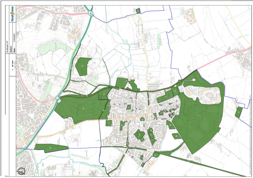
Green Infrastructure
Public Parks and Gardens
| Ref. |
Name | Proximity to Village | Beauty | Historic Significance |
Recreation Value |
Tranquillity | Wildlife | Size |
|---|---|---|---|---|---|---|---|---|
| 1 | Village Green |
Centre of village |
Enclosed with many historic buildings |
In Conservation Area, near museums |
Community Activities Public amenity |
No | No | 4558 sq.m |
| 2 | Elms Park |
Houses to 3 sides |
No | Donated to village |
Sports Children’s play Public amenity |
Away from main roads |
No | 39318 sq. m |
| 3 | Jubilee Field |
Houses to 2 sides | No | Provided by local fundraising |
Sports Children’s play Public amenity |
Away from main roads |
No | 18436 sq. m |
| 4 | Sellors Field |
Edge of village |
No | Donated to village |
Sports Children’s play Public amenity |
No | No | 11373 sq. m |
| 5 | St. Mary’s Park |
Surrounded by houses |
No | No | Sports Children’s play Public amenity |
Away from main roads |
No | 5953 sq.m |
| 6 | Rushcliffe Country Park |
Edge of village |
Woodland, lake, meadows Views of countryside |
Site of GCRN Railway Museum |
Sports Children’s play Public amenity Trails |
Away Has quiet gardens |
Rich mosaic of habitats. Local Nature Reserve |
873917 sq .m |
| 7 | Vicarage Lane Park |
Surrounded by houses |
No | No | Sports Children’s play Public amenity |
Away from main roads |
No | 11143 sq. m |
| 8 | Tongue Way | Surrounded by houses Should be combined |
Includes wetland |
No | Children’s play Public amenity |
Away from main roads |
Some wetland | 1743 sq.m |
| 9 | Churchill Drive Green |
Surrounded by houses |
No | No | Public amenity | Away from main roads |
No | 5354 sq.m |
| 10 | Martin Crescent |
Surrounded by houses |
Includes wetland |
No | Children’s play Public amenity |
Away from main roads |
Some wetland | 2231 sq.m |
Local Allotments
| Ref. |
Name | Proximity to Village | Beauty | Historic Significance |
Recreation Value |
Tranquillity | Wildlife | Size |
|---|---|---|---|---|---|---|---|---|
| 11 | Wilford Road Allotments |
Surrounded by houses |
Gives open outlook for houses |
No | Public amenity for growing crops |
Away from main roads |
No | 10092 sq. m |
| 12 | Hareham Gardens |
Edge of village | Gives open outlook for houses |
Village Charity Est. 1641 |
Public amenity for growing crops |
Away from main roads |
Wooded stream banks, hedges |
17391 sq. m |
| 13 | Buttercup Gardens |
Within 100m of village |
No | No | Public amenity for growing crops |
Away from main roads |
Hedges | 15663 sq. m |
| 14 | Clifton Road Allotments |
Surrounded by houses |
Gives open outlook for houses |
No | Allotments | Away from main roads |
No | 1437 sq.m |
Green Spaces in the main village
| Ref. |
Name | Proximity to Village | Beauty | Historic Significance |
Recreation Value |
Tranquillity | Wildlife | Size |
|---|---|---|---|---|---|---|---|---|
| 15 | St. Peter’s Church yard |
Centre of village | Mature trees | Historic Graves | No | Away from main roads |
No | Reasonable Size, 2900 sq.m |
| 16 | Vicarage Lane Cemetery |
Centre of village | Mature trees | No | Public amenity | Away from main roads |
Trees and hedges |
Reasonable Size, 11705 sq.m |
| 17 | Shaw Street Cemetery |
Centre of village | Mature trees | Rorke's Drift Graves |
Public amenity | Away from main roads |
Trees and hedges |
Reasonable size, 5327 sq.m |
| 18 | St Peter’s school |
Edge of village | No | No | School children’s Sports and play Community events |
No | Habitat areas, woodland |
Reasonable Size, 39227 sq.m |
| 19 | James Peacock school |
Centre of village | Mature trees | No | School children’s Sports and play Community events |
Away from main roads |
No | Reasonable Size, 23249 sq.m |
| 20 | British Gypsum nature area and footpath |
Edge of village | New planting with mature trees and hedges by footpath |
No | Private with footpath adjacent |
Away from main roads |
Still to colonise new areas. Good habitat near footpath |
Reasonable Size, 12924 sq.m |
| 21 | Former railway line |
Between houses | Mature trees | No | Private | Away from roads |
Wild area | Reasonable Size, 14334 sq.m |
Green space beyond the main village
| Ref. |
Name | Proximity to Village | Beauty | Historic Significance |
Recreation Value |
Tranquillity | Wildlife | Size |
|---|---|---|---|---|---|---|---|---|
| 22 | Flawforth churchyard |
1km from village | Mature trees | Historic graves Archaeology |
Public amenity Country views |
Away from main roads |
Trees and hedges | Reasonable Size, 6240 sq.m |
| 23 | Wilwell Cutting |
1km from village | Mature trees and habitat |
No | Public amenity | Away from main roads |
Local Nature Reserve |
Reasonable Size, 76597 sq.m |
| 24 | Ruddington Golf Course |
Edge of village | Mature landscape | No | Golf | Away from roads |
Mixed habitat areas |
Reasonable Size, 410287 sq.m |
| 25 | The Spinney | 1km from village | Woodland Prominent landscape feature |
No | Private Footpaths around edge |
Away from roads |
Priority Habitat Inventor |
Reasonable Size, 90230 sq.m |
| 26 | GCR railway line |
From edge of village to edge of parish |
Linear green feature, views |
Museum railway |
To public as passengers. Footpath adjacent |
No | Habitat on cutting banks |
Reasonable Size, 3788m in length |
| 27 | Course of Packman Dyke |
0-800m from edge of village |
Linear landscape feature |
No | Potential for footpath |
Away from roads |
Aquatic and bankside habitats |
Reasonable Size, 1433m in length |
| 28 | The Bridle path |
0-1100m from edge of village |
Line of mature trees |
No | Public amenity Bridleway |
Away from roads |
Trees and bushes | Reasonable Size, 585m in length |
| 29 | Easthorpe House and field |
Edge of village | Mature trees | No | Private | No | BAP Priority Habitat |
Reasonable Size, 79126 sq.m |
| 30 | Fairham Brook east bank |
500-2500m from edge of village |
Mature trees | No | Private | Away from roads |
Trees, adjacent to Local Nature Reserve |
Reasonable Size, 1745m in length |
| 31 | Long Manor Wood |
1000m from edge of village |
Woodland |
No | Private | Away from roads |
Priority Habitat Inventory |
Reasonable Size, 19987 sq.m |
Tree and hedge lined street
| Ref. |
Name | Proximity to Village | Beauty | Historic Significance |
Recreation Value |
Tranquillity | Wildlife |
|---|---|---|---|---|---|---|---|
| 32 | Loughborough Road | Edge of village | Mature trees and hedges |
No | No | No | Linear habitat |
| 33 | Old Loughborough Road | 0-800m from edge of village | Mature trees and hedges |
No | No | Yes | Linear habitat |
| 34 | Clifton Lane | Within village | Mature trees and hedges |
No | No | No | Linear habitat |
| 35 | Clifton Road south side | Within village | Mature trees and hedges |
No | No | No | Linear habitat |
| 36 | Landmere Lane-Old Road | 500-1000m from edge of village |
Mature trees and hedges |
No | No | No | Linear habitat |
| 37 | Old Road | 500-1000m from edge of village |
Mature trees and hedges |
No | No | No | Linear habitat |
| 38 | Kirk Lane | Within village | Mature trees and hedges |
No | No | No | Linear habitat |
Green verges, islands and open spaces
| Ref. |
Name | Amenity | Tree and Grass | Notes |
|---|---|---|---|---|
| 39 | Vicarage Lane | Yes | Yes | Mature trees in gardens |
| 40 | Asher Lane | Yes | Yes | Verge |
| 41 | Barleylands | Yes | Yes | Open areas around flats |
| 42 | Leys Road | Yes | Yes | Open areas around flats |
| 43 | Sellars Avenue | Yes | Yes | Open areas around flats |
| 44 | Dunblane Road | Yes | Yes | Open areas around flats |
| 45 | Leys Court | Yes | Yes | Open areas around flats |
| 46 | Sheepfold Lane | Yes | Yes | Verges |
| 47 | Elms Park | Yes | Yes | Island |
| 48 | Pear Tree Orchard | Yes | Yes | Verges |
| 49 | Maclaren Gardens | Yes | - | Open area |
| 50 | Shrimpton Court | Yes | Yes | Open areas around dwellings |
| 51 | Easthorpe Street | Yes | - | Verge at east end |
| 52 | Rufford Road | Yes | Yes | Island |
| 53 | St Mary’s Crescent | Yes | - | Verges |
| 54 | Packman Drive | Yes | - | Island |
| 55 | Ashworth Avenue | Yes | Yes | Open areas around dwellings |
| 56 | Clifton Road/Camelot Street | Yes | - | Embankments |
| 57 | Woodhouse Gardens | Yes | - | Open areas |
| 58 | Old Station Drive | Yes | - | Open areas |
| 59 | Pasture Lane/Tongue Way | Yes | Yes | Rain pond |
| 60 | Cooper Gardens | Yes | Yes | Open area by railway |
| 61 | Roe Gardens | Yes | - | Rain pond |
Appendix 3 - Local green spaces
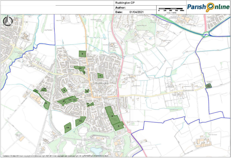
| Map Ref. |
Name | Criteria 1 Proximity to Village | Criteria 2 Beauty | Historic Significance |
Recreation Value |
Tranquillity | Wildlife | Criteria.3 Not being large tracts of land |
Fulfilling LGS Criteria |
|---|---|---|---|---|---|---|---|---|---|
| 1 | Village Green |
Centre of village |
Enclosed with many historic buildings |
In Conservation Area, near museums |
Community Activities Public amenity |
No | No | Reasonable Size, 2735 square metres |
Yes |
| 2 | Village Green |
Centre of village |
Enclosed with many historic buildings |
In Conservation Area, near museums |
Community Activities Public amenity |
No | No | Reasonable Size, 1083 square metres |
Yes |
| 3 | Village Green |
Centre of village |
Enclosed with many historic buildings |
In Conservation Area, near museums |
Community Activities Public amenity |
No | No | Reasonable Size, 740 square metres |
Yes |
| 4 | Elms Park |
Houses to 3 sides |
No | Donated to village |
Sports Children’s play Public amenity |
Away from main roads |
No | Reasonable Size, 39318 square metres |
Yes |
| 5 | Jubilee Field |
Houses to 2 sides |
No | Provided by local fundraising |
Sports Children’s play Public amenity |
Away from main roads |
No | Reasonable Size, 18436 square metres |
Yes |
| 6 | Sellors Field |
Edge of village |
No | Donated to village |
Sports Children’s play Public amenity |
No | No | Reasonable Size, 11373 square metres |
Yes |
| 7 | St. Mary’s Park |
Surrounded by houses |
No | No | Sports Children’s play Public amenity |
Away from main roads |
No | Reasonable Size, 5953 square metres |
Yes |
| 8 | Vicarage Lane Park |
Surrounded by houses |
No | No | Sports Children’s play Public amenity |
Away from main roads |
No | Reasonable Size, 11143 square metres |
Yes |
| 9 | Churchill Drive Green |
Surrounded by houses |
No | No | Public amenity | Away from main roads |
No | Reasonable Size, 5354 square metres |
Yes |
| 10 | Martin’s Crescent |
Surrounded by houses Should be combined |
Includes wetland | No | Children’s play Public amenity |
Away from main roads |
Some wetland | Reasonable Size 2231 square metres |
Yes |
| 11 | Tongue Way | Surrounded by houses Should be combined |
Includes wetland | No | Children’s play Public amenity |
Away from main roads |
Some wetland | Reasonable Size 1743 square metres |
Yes |
| 12 | Wilford Road Allotments |
Surrounded by houses |
Gives open outlook for houses |
No | Public amenity for growing crops |
Away from main roads |
No |
Reasonable 10092 square metres |
Yes |
| 13 | Hareham Gardens |
Edge of village |
Gives open outlook for houses |
Village Charity Est. 1641 |
Public amenity for growing crops |
Away from main roads |
Wooded stream banks, hedges |
Reasonable Size, 17391 square metres |
Yes |
| 14 | Buttercup Gardens |
Within 100m of village |
No | No | Public amenity for growing crops |
Away from main roads |
Hedges | Reasonable Size, 15663 square metres |
Yes |
| 15 | Clifton Road Allotments |
Surrounded by houses |
Gives open outlook for houses |
No | Allotments | Away from main roads |
No | Reasonable size, 1437 square metres |
Yes |
| 16 | St. Peter’s Church yard |
Centre of village |
Mature trees | Historic graves | No | Away from main roads |
No | Reasonable Size, 2900 square metres |
Yes |
| 17 | Vicarage Lane Cemetery |
Centre of village |
Mature trees | No | Public amenity | Away from main roads |
Trees and hedges |
Reasonable Size, 11705 square metres |
Yes |
| 18 | Shaw Street Cemetery |
Centre of village |
Mature trees | Rorke's Drift Graves |
Public amenity | Away from main roads |
Trees and hedges |
Reasonable size, 5327 square metres |
Yes |
| 19 | British Gypsum nature area and footpath |
Edge of village | New planting with mature trees and hedges by footpath |
No | Private with footpath adjacent |
Away from main roads |
Still to colonise new areas. Good habitat near footpath |
Reasonable Size, 12924 square metres |
Yes |
| 20 | Flawforth churchyard |
1km from village |
Mature trees | Historic graves Archaeology |
Public amenity Country views |
Away from main roads |
Trees and hedges |
Reasonable Size, 6240 square metres |
Yes |
| 21 | Pasture Lane/ Tongue Way |
Edge of village |
No | No | Yes | Yes | Yes | 2787 square metres | Yes |
Appendix 4 - List of community projects to be supported by CIL
- Funding for re-building of the new Community Centre on The Green.
- Create new parking within the village centre.
- Purchase of land from Ruddington Grange Golf Club to build a footpath / cycle path connecting Sellors’ Field Estate to St Peter’s School. Toucan crossing at this location, across Wilford Road. (One person supported extending the footpath past Sellors’ Field, possibly along the railway cutting to Old Station Drive).
- Tarmac path to join 50 steps to Vicarage Lane path.
- A press button crossing on Easthorpe Street where the school crossing used to be to cater for the additional school children
which will be coming from the Asher Lane development. - Connect all new estates with footpath/cycle access to village centre.
- Upgrading of grass path between Jubilee Field and Elms Park playing fields to provide tarmacked footpath / cycle path, connecting the Mere Way and Flawforth Lane developments to the village. Provision of Toucan crossing at this location, across Loughborough Road.
- Wheelchair/buggy ramped access over railway line.
- Provide improved mobile phone reception in village centre
- Widen the section of footway on Easthorpe Street beside the barn and narrow this section of roadway to a single lane with an Eastbound priority.
- Provide new and improved Scout Hut.
- Invest in improved left turn from Kirk Lane north on A60 (widen junction). Add repeater signal to assist cars turning right
southbound from A60. - Contributions to heritage railway.
- Produce a footpath map showing the whole Parish and also the Village Centre available as a handout to new residents and visitors.
- New signs with the locations and destinations of footpaths passing through the village.
- Remove the fence between the Tongue Way and Martin Crescent open spaces.
- New play equipment at Vicarage Lane playground.
- Build new library.
- Provide roof repairs and solar panels for St Peter's church.
- Invest in beautifying The Green and corner of Church Street by Co-op.
- Move manhole on edge of cycle path on Wilford Lane.
- Improved traffic lights at Kirk Lane to aid the Mere Way development including pedestrian push buttons.
- Asher Lane development should provide a number of car parking spaces/small car park on its site, to alleviate the loss of car parking along Asher Lane, for the use of residents on Asher Lane and also the visitors to Rushcliffe Country Park or, alternatively, Asher Lane Developers should build/ provide funds for car parking spaces to be made alongside the recycling area on Asher Lane (number to be decided) to alleviate the inevitable loss of car parking along Asher Lane. Spaces to be for the use of residents on Asher Lane and also the visitors to Rushcliffe Country Park.
- A pedestrian crossing on St Mary’s Crescent opposite the footpath entrance.
- Paint footway signage to show the end of the shared pavement on Duttons Hill.
- Replace the sign for the footpath connecting Rufford Road and Loughborough Road.
- Connect end of the 9 stiles footpath (NT.6176) and the Stoney Gate bridle path (NT.5343) as anyone wanting to do a circular walk has to use the verge of the A52 to connect the two, which is unsafe and unpleasant to walk along. This could be achieved by a concessionary footpath at the edge of the adjacent field.
- Provide a footway on Flawforth Lane between Flawforth Avenue and Flawforth Church site.
- Provide a footway on Flawforth Lane between the Flawforth Church site and the stream. This will link footpaths NT.5358 and
NT.6176 to create a circular walk. - New tree planting on - Old Station Drive 2 open areas, Clifton Road/Camelot Street embankments, Ashworth Avenue open areas, Easthorpe Street verge east end, Leys Road open areas.
- Tennis courts (dedicated, not shared use with other sports), a MUGA and a full size petanque piste.
Ruddington Design Guide
The design guide is available separately and is divided as follows.
- Appendix 5: Ruddington Design Guide: Part 1 – Character Assessment
- Appendix 6: Ruddington Design Guide: Part 2 – Design codes for minor development
- Appendix 7: Ruddington Design Guide: Part 3 – Design codes for major and strategic development
Appendix 8 – Core Documents List
CD01 Community facilities list 2019
CD02 Communities facilities map 2019
CD03 Cycle strategy 2019
CD04 Green spaces beyond the main village 2019
CD05 Green spaces in the main village 2019
CD06 Green verges, islands and open areas 2019
CD07 Public parks and gardens 2019
CD08 Tree and hedge lined streets 2019
CD09 Allotments 2019
CD10 Local green spaces (v4) 2019
CD11 Pedestrian Strategy (v3) 2019
CD12 Village Centre Strategy 2019
CD13 Village centre acceptable uses map 2019
CD14 Housing Site Selection Interim Report Local Plan Part 2 2017
CD15 Local List - Rushcliffe 2018
CD16 Nottinghamshire Local Transport Plan Strategy 2011-2026
CD17 Natural England National Landscape Areas 2013
CD18 Rushcliffe Residential Design Guide 2009
CD19 Ruddington Conservation Area Boundary Map
CD20 Ruddington Conversation Area Appraisal 2009
CD21 Ruddington townscape appraisal map
CD22 Rushcliffe Nature Conservation Strategy_2016-2020 2016
CD23 Rushcliffe Local Plan Part 1: Core Strategy 2014
CD24 Rushcliffe Local Plan Part 2: Land and Planning Policies 2019
CD25 Rushcliffe Climate Change Action Plan 2014 - 2020
CD26 CIRIA C753 The SuDS Manual
CD27 The 6Cs Design Guide
CD28 Nottinghamshire Landscape Character Areas 2009
CD29 Neighbourhood Planning and the Historic Environment, Historic England
CD30 Non designated Heritage assets
CD31 Natural England, National Character Areas
CD32 Neighbourhood Plan area designation
CD33 Initial Consultation Poster
CD34 Initial Consultation Questionnaire
CD35 Initial consultation Issues and Options Presentation
CD36 Initial consultation Key Issues Paper (1)
CD37 Initial consultation Key Issues Paper (2)
CD38 Emerging Policies Consultation Poster
CD39 Emerging Policies Questionnaire
CD40 consultation mood boards
CD41 Emerging Policies Document
CD42 Emerging policies consultation exhibition boards
CD43 Emerging Policies Recommendations Report
CD44 Regulation 14 consultation letter
CD45 Draft Neighbourhood Plan (Regulation 14)
CD46 Ruddington Design Guide Part 1, introduction and character assessment
CD47 Ruddington Design Guide Part 2, design code for minor development
CD48 Ruddington Design Guide Part 3, Design code for major strategic development
CD49 Regulation 14 Recommendation Report
CD50 Ruddington Neighbourhood Plan SEA