Radcliffe on Trent Neighbourhood Plan
Radcliffe-on-Trent Neighbourhood Development Plan 2014 - 2028
Contents
- Introduction
- Key Issues and Opportunities in Radcliffe-on-Trent
- Our Vision and Objectives for Radcliffe-on-Trent
- A Spatial Framework for Radcliffe-on-Trent
- The Neighbourhood Plan Policies
- Monitoring and Review
- Appendices
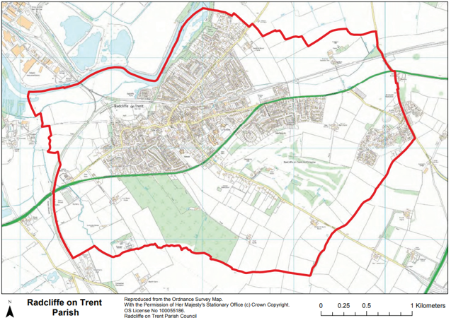
- Appendix 1: Proposals Map 1
- Appendix 2: Proposals Map 2 - Village Centre
- Appendix 3: Strategic Flood Risk Mapping for Radcliffe-on-Trent
- Appendix 4: Glossary
Acknowledgements
This Neighbourhood Plan was promoted by the Radcliffe-on-Trent Parish Council in 2014 and managed by a Steering Committee with professional assistance from Urban Imprint (formally BPUD Ltd, Town Planning & Urban Design Consultants) and the support of Rural Communities Action Nottinghamshire (RCAN) and in consultation with the residents of Radcliffe-on-Trent. The Steering Committee acknowledges the significant help that was given by the Radcliffe-on-Trent Community Plan Group and especially the residents’ survey 2013 which was delivered to every household in the parish and which had a 52% response rate.
The Steering Committee comprised the following members (in alphabetical order):
- Keith Agar (Vice Chairman)
- Rodney Brears
- Paul Collins
- Sue Clegg
- Martin Culshaw
- Kay Cutts
- David Eggleston
- Jacki Grice (Committee Clerk)
- Maggy Holmes
- Sally Horn (Treasurer)
- Jenny Kirkwood
- Philip Marshall
- Georgia Moore
- Alex Raynor
- Martin Ryder
- Mark Shardlow
- Jo Spencer
- Paul Spencer
- Jean Smith
- Hollie Thacker
- Mike Tomlinson
- Roger Upton (Chairman)
- Alison Williams
The Steering Committee would also like to acknowledge the help and assistance given by Cllr Kay Cutts, Cllr Neil Clarke, Cllr Roger Upton and officers from Radcliffe-on-Trent Parish Council, Rushcliffe Borough Council and Nottinghamshire County Council along with the many volunteers and organisations who have all contributed in many different ways towards this Neighbourhood Plan.
1. Introduction
What is the Radcliffe-on-Trent Neighbourhood Plan?
1.1. Neighbourhood Plans are documents which give local people real powers to shape the future of their neighbourhoods. They contain policies written by the community to shape how their local area may change over the Plan period.
1.2. Neighbourhood Planning was introduced by the Localism Act 2011 and is recognised in the National Planning Policy Framework (NPPF), March 2012. The aim of the legislation is to empower local communities to use the planning system to promote appropriate and sustainable development in their area. Neighbourhood Development Plans (Neighbourhood Plan, NDP) must be in general conformity with the Strategic Policies of the Local Planning Authority’s (LPA) Rushcliffe Borough Council Local Plan.
1.3. The designated Neighbourhood Plan area is the Radcliffe-on-Trent parish boundary. The Parish Council sought to ensure the Neighbourhood Plan represented the wishes of the whole community and so established a Steering Committee to facilitate the project and make recommendations on the content of the Plan. The Steering Committee commissioned Town Planning and Urban Design consultancy BPUD to assist as specialist advisors, particularly in the technical writing of the policies. The Steering Committee is
made up of local County, Borough and Parish Councillors, local residents and other stakeholders who have considerable knowledge of and interests in, the life and future of the village, and have managed the project, working closely with BPUD on the background and content of the final document.
1.4. Neighbourhood Plans are to be shaped by the local community. The role of the Steering Committee and Parish Council is to act as facilitators in enabling local interests to determine the focus of their Neighbourhood Plan and devise policies to tackle local issues. The Neighbourhood Plan has been subject to discussion and comments from Nottinghamshire County Council, Rushcliffe Borough Council, Statutory Consultees, other organisations with an interest in the parish, local residents and neighbouring parish councils.
How to use this document
1.5. This Plan contains policies and guidance that are intended to shape development in Radcliffe-on-Trent Parish concurrently with the Rushcliffe Borough Council Local Plan Part 1: Rushcliffe Core Strategy 2014-2028.
1.6. The Plan can be used by different people, but it is likely that it will be most relevant to:
- Local residents and business owners
- Property owners and developers
- The Local Planning Authority (Rushcliffe Borough Council)
1.7. Guidance on how these people are responsible for the implementation of the Plan follows.
- Local residents and businesses can refer to the Plan when consulted on planning applications for new development proposals in Radcliffe-on-Trent. Local people can refer to the Plan when developers carry out early public consultation when drawing up proposals for new development. The wishes and concerns for the future of the parish are expressed in clearly defined policies with legal weight in the planning system. Local people should be pro-active in engaging with the planning system, by checking that the Plan is being properly implemented by developers and Rushcliffe Borough Council when new development comes forward.
- Property owners and developers proposing development in the parish must ensure that their proposals comply with the policies, as relevant to the nature of the development. Developers will find that Neighbourhood Plan policies are a strong reflection of other planning policy at the local and national level, adding additional detail relevant to local circumstances and issues. Planning
applications should, where appropriate, demonstrate how proposed development accords with the policies to contribute to achieving the Plan objectives. - Rushcliffe Borough Council is responsible for implementing the Plan, by considering development proposals against the policies. Proposals that accord with the Plan (and with other relevant planning policies) should be approved, subject to all other relevant concerns. Proposals that do not accord with the policies should not be approved, except where the policies are outweighed by other material considerations.
2. Key Issues and Opportunities in Radcliffe-on-Trent
2.1. In developing this Neighbourhood Plan care has been taken to investigate and balance a number of issues and opportunities identified for the parish of Radcliffe-on-Trent. Some of these key points have been highlighted through the public consultation undertaken (much of which was associated with the Community Plan) and other material identified from a thorough assessment of the plans and policies developed by other agencies, including the Local Planning Authority.
2.2. This chapter should be read alongside the much more detailed and comprehensive baseline assessment which covers a whole range of topics as outlined above. From this seven themes have emerged, which link directly to the objectives in the following chapter of this Plan. A brief introduction to each theme is set out below.
The Village Centre
2.3. Radcliffe-on-Trent benefits from a wide range of shops and services within the Village Centre - a broadly triangular area around Main Road, Shelford Road and New Road. This area includes a range of convenience (daily shopping for food etc.) and comparison (specialist, non-daily items such as household and clothing) retailing. This area also includes the majority of the historical and traditional buildings within the settlement. The centre has a high proportion of independent or privately-owned shops, cafes and businesses which demonstrates the strength of the retail centre. This centre not only services the parish but a wider rural hinterland including Holme Pierrepoint, Shelford, Cropwell Butler and Upper Saxondale.
2.4. Some of the Village Centre has arguably poor architectural and building quality, especially an area to the south of Main Road where a shopping parade, surface car parks and the health centre are located, and there may be opportunities to rejuvenate this area during the Neighbourhood Plan period to help improve the vitality and viability of the Village Centre. This is considered to be a key aspiration of the Radcliffe-on-Trent Neighbourhood Plan.
Public Realm
2.5. The proximity of shops, services and public transport to the homes and businesses in the parish means that the use of sustainable transport is a real possibility. Some of the key detractors from the quality of the village is the lack of adequate car parking, narrow pavements and congested roads within the centre of the village. Much of the centre of the village retains its historical street pattern which, with the coming of motor vehicles has eroded the pedestrian realm.
2.6. The Community Plan clearly set out to improve the quality of the centre of the village in terms of its pavements, streets and the provision of parking, as it is important that the village supports the overall commercial and retail elements within this area.
Transport and Access
2.7. On initial analysis Radcliffe-on-Trent is well served by a variety of transport modes. It has good access to the strategic road networks and a number of public transport options. Rail services from the village are however substandard, both in quality and frequency and are not coupled with an attractive station environment. Access to the eastbound platform for people with physical disabilities is poor and the waiting facilities on both platforms need to be improved. The station car park is in need of major investment to create a modern, secure and attractive facility.
2.8. Bus services linking Nottingham and West Bridgford are good but despite this there are still comparatively low numbers of people within the parish using the bus to travel to work. In this respect, the parish is a typical car-borne community with over 75% of the population using a car or van for the daily commute as opposed to 65% nationally (Source: Census 2011). Parking facilities within the Village Centre, whilst very well-used, are insufficient for the needs of the Village Centre. National Cycle Route 15 runs through the
village but needs significant investment in its infrastructure as it is neither a specific off-road route nor delineated within the road space.
Housing
2.9. The Local Plan Part 1: Rushcliffe Core Strategy requires that a minimum of 400 new homes will need to be built on greenfield land around Radcliffe-on-Trent, with sites to be identified in Local Plan Part 2. The community has acknowledged that there is a clear need for smaller homes for younger families and older people. This is a key issue for the parish with nearly half of the population being in the over 49 age group. Housing delivery in the last ten years has focused on 3- and 4-bedroomed houses, and as a result there is a
need to rebalance the housing mix to meet new and future demands.
2.10. However, the community remains concerned about the impact that new housing on greenfield sites will have on the setting and character of their parish. The Plan seeks to positively address these issues. A number of developers and landowners are actively pursuing planning applications and pre-application discussions on a number of sites in and around the Radcliffe-on-Trent village.
Business and Enterprise
2.11. Rushcliffe Borough Council’s core strategy identifies that improving economic prosperity for all should be a key aim of planning within the Borough. There is a good variety of retail services within the Village Centre, including convenience goods stores, financial and professional services, pharmacies, cafes and eateries and specialist retail stores. These include a high proportion of independent retailers (Baseline survey 2015). There are a very few offices or office based companies in the parish but those that do exist are based heavily on the service sector.
2.12. There is also an increasing growth in residents working from home which further diversifies the employment opportunities within the Parish (Source: Census 2011). In recent years there have been applications for the diversification of farms to rural employment including offices and small workshops. There is little secondary (manufacturing) employment within Radcliffe-on-Trent parish, and primary employment is restricted mainly to agriculture (Source: Census 2011).
2.13. The growth of the parish, in terms of new homes, should be supported by appropriate new economic development within the parish. The Greater Nottingham Sustainable Locations for Growth Strategy identifies Radcliffe-on-Trent as being very attractive for economic development due to its many and varied transport links. More recently there has been a wider discussion about the potential role that Radcliffe-on-Trent could have in helping to create economic development along a corridor stretching from West Bridgford (west) to the neighbouring settlement of Bingham (east), discussed as part of the ongoing strategy development prepared by the local growth board. This collectively offers support for a policy focused on new and improved business and enterprise facilities as part of the parish’s growth.
Design and Heritage
2.14. The parish’s built form is predominantly residential in character apart from the concentration of commercial, civic and retail uses within the centre of Radcliffe-on-Trent. The village has had some post-war growth (1950 – 1970’s estates) although, in the latter part of the 20th Century the village has been more contained as a result of planning policies and the designation of the Greenbelt. Most of the townscape is two or three storeys and there are no high-rise elements.
2.15. There are no Conservation Areas within Radcliffe-on-Trent village, but Upper Saxondale, built in the grounds of a former hospital dating from the first decade of the 20th Century, is so designated. The centre of the village has a number of listed buildings most of which are 19th Century, including St. Mary’s Church which dominates both the skyline and the townscape with its stone tower. Few buildings are given any statutory protection so it is important that the Neighbourhood Plan seeks to retain and enhance the village’s unique characteristics through appropriate policies.
Environment
2.16. The wider countryside of Radcliffe-on-Trent is highly valued by its community. It is identified as being within the South Nottinghamshire Farmlands Character Area (NCC designation) and is described as being a rolling arable farmland landscape. Its protection and enhancement is a key goal for the Neighbourhood Plan as outlined by the community. A number of landscape features have some importance but none are statutorily protected but the landscape and local environment has some benefit for wildlife, specifically farmland birds. In addition, a number of Local Wildlife Sites (LWS) are identified within the parish.
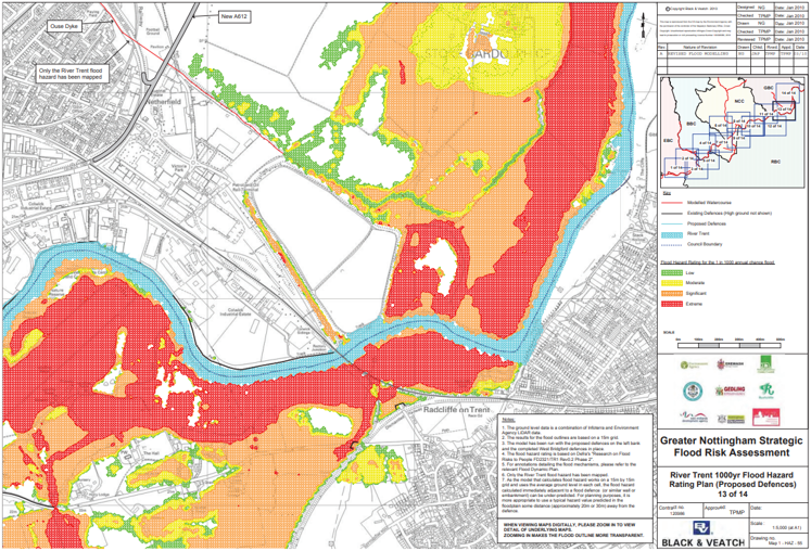
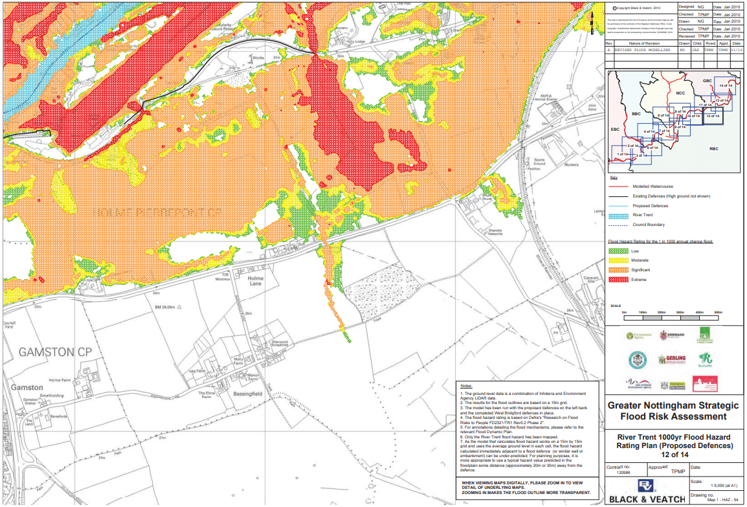
2.17. Proximity to the River Trent not only offers a wide range of opportunities for recreation and leisure, but also means that some areas of the parish are unsuitable for development given their designation at risk of flooding (see appendix 4 for the most up-to-date flood-risk mapping). This is mainly to the north and west of the parish, predominantly north of the railway embankment, on low-lying land adjacent to the River Trent. There are no directly relevant air quality issues within the parish, but further along the A52 towards
Nottingham City Centre there are Air Quality Management Zones.
3. Our Vision and Objectives for Radcliffe-on-Trent
3.1. The following vision has been developed to guide development of the objectives and policies for the Neighbourhood Plan. The vision takes forward the goals and aspirations of the Community Plan where they are relevant to land-use planning.
“Radcliffe-on-Trent aspires to be a vibrant and sustainable village with a pedestrian-focused approach to land-use planning whilst continually endeavouring to protect its strong sense of rural identity and community cohesion and enhance its rich and distinctive architectural, social and historical assets.”
Objectives
3.2. The following objectives have been developed to assist with the delivery of the policies and strategies that form this Neighbourhood Plan:
- Village Centre - To promote Radcliffe-on-Trent Village Centre as a thriving, attractive and safe retail and service area supporting a range of independent shops.
- Public Realm – To deliver a more pedestrian-friendly Village Centre, with improved pedestrian and cycle routes and high quality, safe and well-designed streets and spaces as part of new developments.
- Transport and Services - To prioritise sustainable modes of transport, with particular focus on improving bus and rail provision, and promote good access for all to public services and facilities.
- Leisure – To significantly improve the sports and leisure facilities for all residents by providing for new facilities (including places for young and old to socialise), whilst protecting those that exist.
- Housing – To ensure that a balanced supply of housing is achieved in Radcliffe-on-Trent, focussing on improving choices for different age groups whilst promoting sustainable location of new houses and setting high standards of eco-design and energy efficiency.
- Employment – To ensure that the existing businesses within the parish are supported in their operation and growth, whilst offering sustainably located opportunities for new development encouraging the creation of small and medium sized enterprises and their investment in the parish.
- Design and Heritage – To protect and enhance heritage and architectural assets whilst promoting high quality design in all new development in the parish contributing to the village sense of place and identity.
- Environment –To protect and enhance the rural setting and local biodiversity of the village and parish and promote a network of green spaces and wildlife corridors connecting the village, the River Trent and the countryside.
4. A Spatial Framework for Radcliffe-on-Trent
Sub-Regional Framework
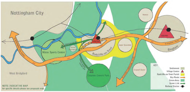
4.1. The Sub-Regional Framework presents the village of Radcliffe-on-Trent within the wider context of the Growth Corridor linking West Bridgford, Radcliffe-on-Trent and Bingham. The diagram demonstrates how well connected Radcliffe-on-Trent is within a wider sub-regional setting and how this allows it to contribute singularly to a wider economic renaissance. Intersected by key arterial road and rail routes, Radcliffe-on-Trent is conveniently located to provide valuable opportunities for living, working and spending leisure time in the area.
4.2. In addition, this diagram demonstrates Radcliffe-on-Trent’s location within a wider landscape setting. Two green areas play a key role in preventing coalescence between Radcliffe and Nottingham and Radcliffe and Bingham. It is important that these are preserved as part of any ongoing Greenbelt review to maintain the identity and distinctiveness of the settlements within this area. The diagram also highlights opportunities to link Radcliffe-on-Trent to nearby leisure and recreation resources at Cotgrave Country Park and the Water Sports Centre - both valuable sub-regional recreational resources - via existing walking and cycling links along the Trent Valley Way and a new link along the disused Cotgrave Mineral Railway.
4.3. Overall this strategic diagram highlights the importance for the Neighbourhood Plan to recognise, promote and encourage the role that Radcliffe-on-Trent plays within the wider sub-regional context. The village should be outward looking, contributing to the local area, whilst maximising the wider benefits provided by the corridor to the settlement. It demonstrates the crucial role of key links such as Radcliffe Railway Station, frequent bus services and the Trent Valley Way and National Cycle Route 15, in providing residents with
alternative sustainable modes of transport to key local and regional destinations. As a result, limited economic development, coupled with housing growth are, if sensitively delivered, able to contribute to the ongoing future of the village.
Radcliffe-on-Trent Parish Framework
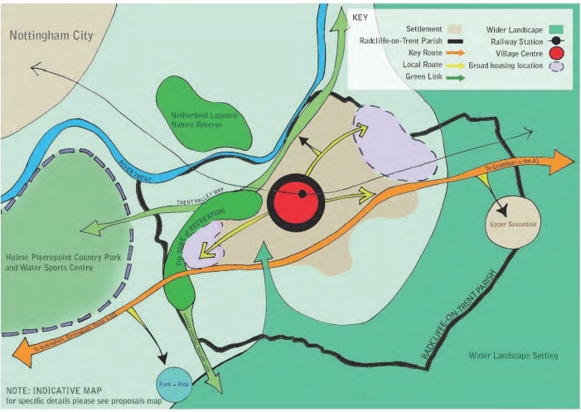
4.4. The spatial strategy for the parish of Radcliffe-on-Trent is shown in the above diagram. The village has a historical relationship with the rural hinterland, which remains important to residents and local businesses today. The Village Centre is the point from which key routes through the village intersect and the location for the clustering of shops and services which serve the population. This diagram also demonstrates how the Neighbourhood Plan will seek to reinforce existing green links and the clustering of sports and recreation facilities. The Zone of Recreation is identified as the broad location in which new sports and recreation facilities will be considered appropriate.
4.5. The Neighbourhood Plan will not allocate specific housing sites but the spatial strategy indicates the broad locations where housing may be considered acceptable in meeting the need identified by the Rushcliffe Local Plan: Part 1. A key consideration of the Neighbourhood Plan is to ensure the ‘walkability’ of the village is maintained. The appropriate density of housing in these broad locations is indicated by the shade of purple. In order to meet the housing targets assigned to Radcliffe, a review of the Greenbelt will be required. The spatial strategy proposes the majority of the release to the east and the west, allowing gaps in the settlement boundary to be ‘infilled’, preserving the separation between settlements to the east and west.
4.6. The Village Framework is based around the centre of the village, which includes a broad selection of facilities. Community facilities, transport routes and key shopping areas all play key roles in making the Village Centre vibrant and a key resource for residents of the wider parish. The Neighbourhood Plan focuses on making this Village Centre a pedestrian-friendly area with improvements in the area’s general quality and appearance. Wholesale improvements are identified for an area south of Main Road adjacent to the
shopping area, an area that has strategic as well as local benefits.
4.7. The Village Centre is the focus of main community, commercial and retail uses. Green stars indicate the points where key transport links intersect and interchange. These make up three corners of a triangle of economic activity comprising the heart of the village. The Village Centre is the area within the purple dashed line. It is important that the railway station plays an increasingly central role in the future of the economic, environmental and social success of the village.
5. The Neighbourhood Plan Policies
5.1. The following table demonstrates how all the policies set out in the Neighbourhood Plan meet the objectives set out in Chapter 3. In each case the policy developed should address more than one of the objectives, although there are some very specific policies designed to deliver targeted and specialist elements of the objectives which may not address more than one.
A - The Village Centre
| Policy | Objective 1 | Objective 2 | Objective 3 | Objective 4 | Objective 5 | Objective 6 | Objective 7 | Objective 8 |
|---|---|---|---|---|---|---|---|---|
| Policy 1: Village Centre First | Yes | - | - | - | Yes | - | Yes | - |
| Policy 2: Public Space | Yes | Yes | Yes | - | - | - | Yes | Yes |
| Policy 3: Main Road Regeneration Area | Yes | Yes | - | - | Yes | Yes | Yes | Yes |
B - Recreation and Environment
| Policy | Objective 1 | Objective 2 | Objective 3 | Objective 4 | Objective 5 | Objective 6 | Objective 7 | Objective 8 |
|---|---|---|---|---|---|---|---|---|
| Policy 4: Local Green Space | - | Yes | - | Yes | - | - | Yes | Yes |
| Policy 5: Local Leisure Provision | - | - | - | Yes | Yes | - | Yes | Yes |
| Policy 6: Biodiversity Network | - | Yes | - | Yes | - | - | - | Yes |
C - Transportation and Connectivity
| Policy | Objective 1 | Objective 2 | Objective 3 | Objective 4 | Objective 5 | Objective 6 | Objective 7 | Objective 8 |
|---|---|---|---|---|---|---|---|---|
| Policy 7: Pedestrian Focused Development | - | Yes | Yes | - | Yes | Yes | Yes | - |
| Policy 8: Public Transport | Yes | - | Yes | - | Yes | - | - | Yes |
| Policy 9: Railway Station | Yes | - | Yes | - | - | Yes | - | - |
D - The Village Centre
| Policy | Objective 1 | Objective 2 | Objective 3 | Objective 4 | Objective 5 | Objective 6 | Objective 7 | Objective 8 |
|---|---|---|---|---|---|---|---|---|
| Policy 10: Residential Development Strategy | - | Yes | - | - | Yes | - | Yes | - |
| Policy 11: Infill Development | - | - | - | - | Yes | - | Yes | - |
| Policy 12: Housing Mix and Density | Yes | - | - | - | Yes | - | Yes | Yes |
| Policy 13: Business & Enterprise | - | - | Yes | - | - | Yes | Yes | - |
E - Design and Heritage
| Policy | Objective 1 | Objective 2 | Objective 3 | Objective 4 | Objective 5 | Objective 6 | Objective 7 | Objective 8 |
|---|---|---|---|---|---|---|---|---|
| Policy 14: Design and Layout | - | Yes | - | Yes | Yes | Yes | Yes | Yes |
| Policy 15: Local Architectural Styles | - | - | - | - | Yes | Yes | Yes | Yes |
A. The Village Centre Policies
Introduction
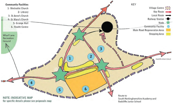
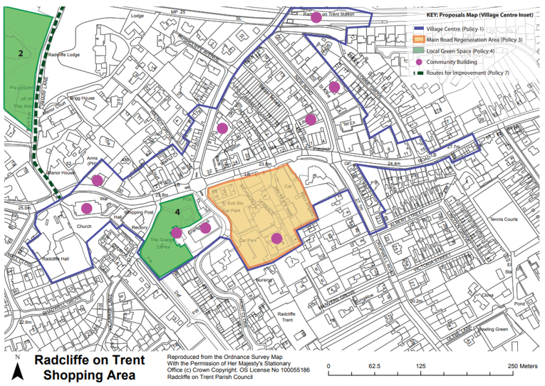
5.2. Enhancement of the Village Centre of Radcliffe-on-Trent is key in drawing together the aspirations of the Neighbourhood Plan. Consequently, many other issues and resultant policies in the Neighbourhood Plan are linked to the role of the Village Centre, including a triangle bounded by Main Road, Shelford Road and New Road and also encompassing key services and facilities such as the railway station, library, health centre and The Grange / Grange Hall Community Centre. The Village Centre is the pivot of many aspirations,
from increasing pedestrian priority through improvements to public realm, traffic and parking, to protecting and heightening the vibrancy of the parish
Policy 1: Village Centre First
The Neighbourhood Plan encourages the clustering of retail, commercial and community services within, or adjacent to, the Village Centre as identified on the proposals map subject to ensuring adjacent access and parking. Outside the Village Centre, applications which will result in over 280sq/m of retail space will be resisted unless it can be demonstrated that they meet the sequential and impact tests. Within the Village Centre the diversification of existing public buildings for additional community uses will also be supported and
encouraged.
Within the Village Centre, the development of new shops (Use Classes A1-4) and other retail and commercial uses are encouraged, particularly where they can contribute to a strong active frontage. At ground floor level, proposed change from retail / commercial to residential within the identified retail frontages will be resisted unless it can be demonstrated that there is no viable retail use. Applications for proposals that involve takeaways (Use Class A5) will be determined on a case-by-case basis, taking special account of the impacts on local parking and amenity.
Development, wherever located, that is able to positively contribute to reducing traffic flows and impacts through the Village Centre, or mitigating traffic impacts on the Village Centre, will be looked upon favourably.
Justification
5.3. This policy will focus upon new retail, commercial and community services (such as the health centre developments), with priority given to sites which can contribute towards the creation of an attractive and vibrant Village Centre and benefit from the sustainable transport modes in that location. This policy is designed to support the vitality and viability of the shops and services within the Village Centre. The policy also limits retail development outside the Village Centre, to only 280sq/m (a size for a small retail store of a size that is exempt Sunday trading laws as it provides the function of a convenience store as defined by HMRC). Further, the policy discourages loss of retail units on the ground floor within the Village Centre through resisting their conversion to residential use. This policy also supports the diversification of uses of existing community buildings and spaces for wider / other community uses or to support retention of existing services. Whilst in principle new takeaways (A5 Use Class) are not discouraged by the Neighbourhood Plan, care needs to be taken that the impacts (noise, smells) on amenity and the impacts on local parking, including fly-parking, are properly considered.
Policy 2: Public Space
Where required, planning permission will normally be granted for schemes which singularly or cumulatively improve the public realm within the Village Centre. Such schemes should purposefully prioritise pedestrians within road and junction layout design using high quality, robust materials.
These improvements should focus on delivery of the following elements:
- Public realm improvements and improved pedestrian crossings
- Improved integrated parking provision
- Improved accessibility for those with reduced mobility or visual impairment (disabled bays, ramps and additional seating areas)
- Ensuring that designs and proposals consider access for all, including the visually impaired and those of impaired mobility.
Schemes within the Village Centre should, where appropriate, contribute to the improvement of the public realm, including ensuring that pavements and forecourts are reinstated to a high quality in line with the criteria set out above. The Neighbourhood Plan supports the creation and enhancement of spaces for markets and community events along Main Road or adjacent to existing community facilities.
Justification
5.4. This policy supports improvements to the public realm of the centre of the village by promoting a ‘pedestrian first’ approach to road and junction layout. Revitalisation of existing spaces is encouraged through use of innovatively designed shelters and seating areas in addition to public realm improvements and changes to ensure excellent access for all. This policy also seeks to provide new spaces within the Village Centre for residents to socialise, community events to be held and markets and fayres to take place.
5.5. The Parish Council and its partners will continue to work closely with the NCC Highways and Rushcliffe Borough Council to deliver wider public realm improvements. It is hoped that this policy will work in partnership with their efforts, coordinating works by developers and investors.
Policy 3: Main Road Regeneration Area
The Neighbourhood Plan supports the regeneration of an area identified to the south of Main Road for mixed use redevelopment. Schemes which focus on retail and community uses with appropriate parking provision will be supported subject to ensuring long term viability of new and existing uses. Where appropriate, schemes should contribute to create a pedestrian friendly environment along Main Road, limiting traffic flow and ensuring appropriate parking and servicing.
All schemes, whether for all or part of the regeneration area, should ensure that they contribute to the delivery of strong links between this site and other areas within the Village Centre (including Main Road) through well designed pedestrian and cycle routes and that they are responsive to the scale, form and layout of the surrounding townscape.
Justification
5.6. An area to the south of Main Road has been identified as a key area for regeneration within the Village Centre. The area is identified for possible redevelopment during the Plan period with a focus on retail and community uses. Support will be given for mixed use schemes which include new or improved community uses, demonstrating high quality design.
5.7. The area is currently occupied by surface car parks, large under-developed sites and the health centre which is identified as requiring upgrading. Some buildings are poor quality in terms of design, detracting from the overall character of the Village Centre. This policy supports development schemes in this area to help lift the quality of the urban environment and make best use of previously developed land within this area.
B. Recreation and Environment Policies
Introduction
5.8. Radcliffe-on-Trent benefits from being located in the Nottinghamshire countryside with many outdoor and indoor recreation and leisure facilities, although gaps in this provision have been identified. The Neighbourhood Plan seeks to protect and enhance these assets, placing special value on elements which offer biodiversity and wildlife benefit whilst seeking access to these facilities for all residents.
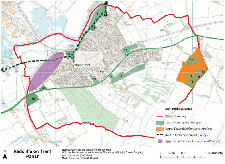
Policy 4: Local Green Space
The Neighbourhood Plan designates the following areas as Local Green Spaces due to their special character
and significance and recreational value as identified on the proposals map. These sites will be protected from
inappropriate development. Where appropriate new or extensions to existing recreational facilities, will be
supported.
- Malkin Hill and Cliff Walk (Trent Valley Way)
- Wharf Lane Recreation Ground
- Dewberry Hill
- The Grange Grounds
- Rockley Memorial Park
- The Lily Ponds
- Allotments, Grantham Road
- Allotments, Nottingham Road
- Bowling Greens at Cropwell Road and Upper Saxondale
- Cricket Club, Radcliffe Road
- South Nottinghamshire Academy Bingham Road Playing Field
- Radcliffe Junior School Playing Field
- Copse/Triangle at Bingham Road
- Valley Road Play Area
- Amenity Space and gardens at the former hospital at Upper Saxondale
Justification
5.9. This policy designates several Local Green Spaces. These must meet certain criteria as set out within the National Planning Policy Framework paragraph 77 which states that designation should only be used where the green space is in reasonably close proximity to the community it serves, is demonstrably special to a local community and holds particular significance, local in character, and is not an extensive tract of land. The areas identified in this policy have been chosen for Local Green Space designation due to their contribution to the parish in a number of ways. Other areas do exist but are covered by landscape designations, already being afforded sufficient protection. The Golf Club is not included as this is considered to be an extensive tract of land and so does not meet the appropriate tests.
Policy 5: Local Leisure Provision
The Neighbourhood Plan identifies the priority for the improvement of the Village’s formal sports facilities for all ages. Where appropriate, financial contributions may be sought from developers, in lieu of on-site provision. These contributions should be targeted towards enhancement of existing, and provision of new, off-site facilities within the recreational zone as marked on the proposals map, to enhance and create the sports and recreation hub for use by the wider community.
New facilities, located adjacent to existing ones, should focus on the provision of new sports pitches and associated requirements such as changing rooms, security fencing and lighting. Applications for these will be supported providing that they do not erode nearby residential amenities and are located to benefit from sustainable transport links (walking, cycling and public transport). The Neighbourhood Plan supports the provision of small scale children’s play and ancillary open space as an integral part of new developments where it is not appropriate for them to be co-located with the sports and recreation hub.
Justification
5.10. The recreation zone (as identified within the spatial strategy) spans an area between the Cricket Club and The Wharf Lane Recreation Ground and is an area where there is an existing concentration of leisure and recreational facilities. The Neighbourhood Plan seeks to focus these here to encourage a hub of such activities within accessible distance of the Village Centre. Policy 5, in parallel with Policy 4 of the Neighbourhood Plan, seeks to protect and enhance existing recreation facilities such as the Bingham Road Playing Fields.
5.11. Developers and applicants are encouraged to make off-site contributions to larger-scale recreational facilities within the zone identified for recreation which is located to the north west of the settlement adjacent to the disused mineral railway line to Cotgrave. This will allow new facilities to link or share with other recreational activities nearby, including other links with Holme Pierrepoint to the west. The focus will be on playing pitches and the creation of a linear park linked with a new footpath and cycle route along the
disused mineral railway line to Cotgrave. This strategy (set out within the Spatial Strategy) is designed to make best use of existing facilities but to also address any deficiencies identified by the community.
5.12. New residential development should have small scale active leisure facilities provided on-site, such as playgrounds for young children, to enhance the sustainability and attractiveness of these living and working locations. It may be appropriate for developers to offer a financial contribution towards off site provision for larger sports and recreational facilities as part of planning applications for larger schemes.
Policy 6: Biodiversity Network
Developments which include provision for, or contribute to, the establishment and retention of a network of green and blue infrastructure within the parish will be looked on favourably. Proposals which contribute towards new links and / or enhancement of the existing green infrastructure network will be supported, both in and out of the parish. Proposals should consider opportunities to retain, enhance and incorporate features which are beneficial for wildlife and habitat creation through their landscape proposals and design.
Justification
5.13. Radcliffe-on-Trent Parish includes two Biodiversity Focal Areas (Cotgrave Forest and Trent Valley(Lady Bay to Stoke Bardolph)) identified within the ‘Rushcliffe Biodiversity Opportunity Mapping Report’ – C Jackson and N Crouch 2015 – published by Nottinghamshire Biodiversity Action Group. The parish, therefore, is important for its biodiversity and opportunities exist to protect and enhance this network, including by providing new linkages between sites and ensuring the appropriate management of existing sites and green spaces. This policy promotes a network of green spaces to support local wildlife and its habitat offer both inside and beyond the parish. It refers to a proposed green and blue infrastructure network which identifies key biodiversity corridors (hedgerows, rivers, footpaths) and green spaces (parkland) and highlights areas where development can contribute to this. Developments can assist by incorporating habitat enhancing features such as bird or bat boxes or appropriate native woodlands, planted tree and hedgerow boundaries, ponds, wetlands and meadows or other enhancing features.
C. Transportation and Connectivity Policies
Introduction
5.14. Radcliffe-on-Trent benefits from bus and rail services and is a village generally walkable for most residents, although there is still a heavy reliance upon the car. The ability of parish residents to access facilities within the village and the ease with which they can move around the area are key to promoting a sustainable future and the wellbeing of the community over the Plan period. In connection with these policies it is important that traffic through the village is discouraged wherever possible and that pedestrian safety is enhanced through appropriate speed reduction measures.
Policy 7: Pedestrian Focused Development
All residential schemes should provide a clear hierarchy of new streets and spaces as set out within the Rushcliffe residential design guide SPD (2009). Developments which take a pedestrian first approach to the design of streets and spaces and road layout, such as delivering ‘home zone’ designs will be looked upon favourably.
Schemes should be designed with particular attention given to provision or improvement of off-road routes between the site and surrounding open spaces and facilities, the wider footpath network and where appropriate, key community facilities, specifically routes to the east of the village linking across the railway line. Schemes that do not take opportunities to improve or enhance this network may not be supported.
The following key routes are identified on the proposals map for protection and enhancement and where appropriate, may benefit from developer or other contributions:
- The Trent Valley Way – including Malkin Hill Cliff Walk / Holme Lane
- Disused mineral railway line to Cotgrave
- Public footpaths to the south and west of the village leading to Cotgrave Country Park
- National Cycle Route 15
Justification
5.15. This policy reflects the clear hierarchy of modes of transport as identified by national policy and guidance (including Manual for Streets 1 and 2) which is as follows: pedestrians and the disabled, cyclists, public transport services (bus and train), with private cars having last priority. This approach is also supported by the Design Councils ‘Building for Life 12’ scheme as outlined in policy 14 of this document. The policy identifies key routes for enhancement and investment with particular focus on ‘safe corridors’ of travel and
making use of existing assets such as the river bank and the former mineral railway line. Developer contributions may be sought to invest in these corridors. Improvement to off-road routes for pedestrians and cyclists are encouraged, as these will make it more attractive for new and existing residents to use sustainable modes, as outlined above, to access key services. The community, through consultation, has identified that a pedestrian crossing of Shelford Road between Queens Road and Clumber Drive, would be supported. A new link across the railway line to the east of the village would also be beneficial.
Policy 8: Public Transport
The Neighbourhood Plan seeks to encourage improvement to the parish’s transport network making key services and facilities more accessible without the use of a car. All new housing developments should be located wherever appropriate, to take maximum advantage of existing services and facilities. Proposals for new residential development should demonstrate that most new development will be located within walking distance of public transport, equating to 400m/¼ Mile from the site’s furthest point and 1600m or 1 mile to community facilities and the Village Centre from the centre of the site. Where developments are significantly outside these distances, new development is unlikely to be considered acceptable. Account will be taken of development which includes new community facilities and services when assessing a potential development’s accessibility.
Where Travel Plans are required in line with the County Council ‘Guidance on Transportation Assessment’ or any subsequent document, they should demonstrate clearly how workers and residents will commute to and from the site.
Justification
5.16. The Neighbourhood Plan will focus on access to services and facilities and improving connectivity in the transport network for all members of the community, to services and facilities and neighbouring settlements. New developments should seek to encourage walking and cycling and use of public transport. The policy encourages sites within 400m (¼ Mile) of a bus stop and 1.6 km (1 mile) from local facilities, such as the railway station, library and health centre, as this is considered in best practice to be an appropriate
walking distance for residents (as set out in the Guidance for Transport Assessments standards prepared by the Department for Transport).
Policy 9: Radcliffe-on-Trent Railway Station
The Neighbourhood Plan supports the retention and enhancement of the Radcliffe-on-Trent railway station. Development which contributes towards or seeks to establish improved and formalised parking provision, access arrangements, waiting and information facilities (where these require planning permission) will be supported. The Neighbourhood Plan particularly support schemes which increase or improve car parking provision at the station.
Schemes that would undermine the ability to access for people of all abilities, or use the station facilities both now and in the future, will be resisted.
Justification
5.17. A key priority for the village is the protection and enhancement of the railway station both in terms of striving to retain and increase the services which currently stop at the village station, and promoting the village’s role within the growth corridor identified by Rushcliffe Borough Council. Additionally, the Neighbourhood Plan supports schemes which improve parking and access arrangements designed to encourage the use of this sustainable transport mode.
D. Housing Policies
Introduction
5.18. Radcliffe-on-Trent village has a housing target of a minimum of 400 homes to be provided over the Rushcliffe Local Plan period. The Neighbourhood Plan does not allocate specific sites to meet this need, but instead details a broad strategy for how the distribution of new dwellings across the parish is to be approached.
5.19. The Neighbourhood Plan also seeks to encourage a balance of new and revitalised employment to support this housing growth in a sustainable manner.
5.20. The policies in this section also set out the requirements for housing infill, depending on their proximity to the Village Centre.
5.21. In this section, the Neighbourhood Plan sets out the types and density of housing to be provided by new housing developments.
5.22. Collectively these policies will help guide decisions on housing proposals within the parish.
5.23. The policies in this section are designed to ensure that development delivers, as far as possible, the spatial strategy set out in chapter 3 of this Neighbourhood Plan (the diagram which focuses on Radcliffe-on-Trent village is repeated below).
MAP
Policy 10: New Residential Development (Locational Strategy)
The Neighbourhood Plan makes the provision for the delivery of a minimum of 400 dwellings on greenfield sites outside the existing built up area of the village of Radcliffe-on-Trent, to meet the requirement set by the Rushcliffe Borough Council Local Plan: Part 1.
The following criteria should be used to determine the acceptability of any application for new homes (or allocations as part of the Local Plan: Part 2) which come forward adjacent to the settlement boundary of Radcliffe-on-Trent. These ensure that new development reflects the overall spatial strategy for the parish set out as part of the Neighbourhood Plan. Schemes which meet all of the following 10 criteria will be looked upon favourably.
Residential development sites should be:
- Located directly adjacent to the existing settlement edge with priority given to sites which border the existing settlement boundary on two or more sides.
- Located where the centre of the site is accessible by walking, cycling and public transport in accordance with the standards set out in policy 8 of the Neighbourhood Plan.
- Located where there is reasonably good access to the strategic highways network (specifically the A52 Nottingham Road), without causing significant congestion to the village roads.
- Located to avoid those areas of the parish which are unsuitable for development given their designation as being at risk of flooding (see Appendix 4 for the most up-to-date flood risk mapping). This is mainly to the north and west of the parish on low-lying land adjacent to the River Trent.
- Designed to deliver development on a number of sites (cumulatively over the plan period to 2028) so that the direct impacts of development are spread across the village.
- Designed to include an element of commercial office space alongside residential development, where this is appropriate, as set out in policy 13 of the Neighbourhood Plan.
- Designed to ensure that a logical and defensible settlement boundary to the landscape and wider Greenbelt is created by the new development (e.g. to a road, footpath, hedgerow or watercourse).
- Designed to accommodate appropriate open space and parkland in line with policy 5 and the Local Plan: Part 1 and ensure access to existing facilities is maintained and/or enhanced.
- Designed to deliver the overall mix and density as set out by policy 12 of the Neighbourhood Plan.
- Designed sensitively so that they do not negatively impact any built or natural environment designations at the national, local and neighbourhood level.
Justification
5.24. This is an important policy within the Neighbourhood Plan given that it will guide the acceptability of new housing in the parish as well as the preparation of future planning policy documents. The policy has been developed following a thorough test of 8 different options and strategies as part of the Sustainability Assessment which accompanies this Plan. The policy is based around 10 key tests, or criteria, which are designed to act as a guide for any decision maker or developer / housebuilder in determining the acceptability of any residential proposal. The most appropriate proposals are likely to be able to meet all of the criteria set out above and should be supported. If faced with two or more competing sites this policy would help the decision makers to determine the most appropriate of these schemes.
5.25. The paragraphs below provide a short summary of the way that these criteria may be used. The numbers refer directly to each criterion / requirement.
- A well located site should have a common boundary with existing development at the edge of Radcliffe-on-Trent village. To ensure that sites don’t ‘stick out’ from the edge in an awkward manner, potentially to the detriment of the Greenbelt and landscape, schemes that have existing development on two or more sides will be able to better fulfil this goal.
- Policy 8 of the Neighbourhood Plan states that sites should be within 1.6km or 1 mile of the Village Centre as is shown on the proposals map (edged blue). This means that any site would be approximately 20 minutes walk from the shops, services and facilities around the centre of the village. This is important to ensure that new development benefits from the facilities and shops on offer and in turn, supports their viability.
- Traffic is a key issue for the community and it is important that any traffic generated by the development can easily access the strategic highways network and not cause unnecessary congestion on local roads. The A52 is specifically mentioned as it is the most important vehicular route within the parish and connects places of work, education and larger shopping opportunities.
- Planning policy should seek to avoid the risk of flooding. This policy ensures that in making decisions about flooding the most up to date flood risk mapping is available. It is likely that this will be periodically updated and so decisions will be made on the most recent information available. The principal risk is to the far west of the parish adjacent to the River Trent (the most recent flood risk map is in the Appendix 4).
- Community consultation has emphasized that locating all 400 new houses on one site would be detrimental to local character and amenity (e.g. effects upon landscape and traffic). Disaggregating the total number, whilst ensuring that sites are large enough to deliver necessary infrastructure, addresses this issue.
- It is important that jobs are created alongside new homes. Policy 13 supports new office and starter-units for small and new businesses and this requirement ensures that at the very early stage the implications and benefits of this are effectively considered.
- Any new development will create a new ‘edge’ to the settlement and will remove some land from the Greenbelt. It is important that the new settlement edge created is of high quality and has a physical presence, being a defensible boundary, to prevent the settlement boundary from ‘creeping’ over time. Field boundaries, water courses and other landscape features would be most appropriate.
- Policy 5 and the Local Plan: Part 1 offer some clear requirements for open space and parks. Ensuring good access to new and existing open spaces and recreation is an important aspect of this Neighbourhood Plan.
- There are some very clear requirements within the Neighbourhood Plan for new residential development in terms of the type of houses and their density. Depending on the size and location of the site, the scheme’s ability to respond positively to these, will determine the overall acceptability of any site that comes forward.
- It is vitally important that, regardless of any other factors, any new development does not negatively impact on any formally designated area. These might include protected habitats or species, heritage buildings or landscape features. In some cases, appropriate mitigation could be suggested, but without this, a scheme is unlikely to be acceptable in planning terms.
Policy 11: Infill Development
The Neighbourhood Plan considers that infill development within the settlement boundary may be appropriate. A site constitutes infill development when it is bounded by existing development on two or more sides and is within the existing settlement boundary (as defined by the Local Plan: Part 1).
The design and layout of infill development requires careful attention to relate to its existing settlement context and character. Infill development should respect the existing massing, building form and heights of buildings within their immediately locality. Front and rear building lines should be continued where these are well established and clearly defined as part of the existing settlement pattern. The side spacing to neighbouring properties should be maintained where a consistent and regular arrangement already exists. Overshadowing or overlooking of both new and existing dwellings should be avoided or minimised through careful attention to design privacy and there should be a clear distinction between public and private areas.
Schemes which propose new development on a previously developed site will also be supported where it can be demonstrated that the design and density reflects the immediate local surroundings subject to compliance with other development plan policies (specifically policies 14 and 15 of this Plan). Within the Village Centre a higher proportion of affordable houses and smaller, higher density units may be supported subject to compliance with other development plan policies.
Justification
5.26. This policy specifically deals with residential schemes considered to be infill plots. For a site to be considered infill development it must adjoin the settlement on at least two of its boundaries. It also states that infill sites located within the Village Centre will be required to make a greater contribution to the provision of affordable housing and will be able to provide smaller higher density units due to their more sustainable location.
Policy 12: Housing Mix and Density
On all residential schemes in excess of 10 dwellings the following broad mix of types will be sought subject to viability, deliverability and the location of development:
- 25% 1 & 2 bed properties for older persons either as retirement apartments or as bungalows
- 30% 2 bedroomed homes
- 25% 3 bedroomed homes
- 20% 4+ bedroomed homes
Schemes of fewer than 10 dwellings should seek to provide 2-bed starter homes, bungalows for the elderly, and/or 1 and 2 bedroomed flat accommodation, suitable for a variety of occupiers.
The eventual mix will be defined by its proximity to public transport routes, local shops and facilities and the location within the settlement reflecting local built character and density, ensuring that higher densities are placed adjacent to arterial routes and within the centre of the settlement. Schemes which form a new edge to the settlement must ensure that densities are commensurate with the surrounding townscape and landscape character and may result in lower densities. The design and layout of schemes should ensure that where possible the above mix is achieved.
Affordable Housing
In line with the Local Plan Part 1, any residential scheme of 5 or more units, regardless of mix or location, will seek the provision of 30% affordable housing where viable with particular focus on providing homes for young people and young families.
Justification
5.27. This policy seeks to ensure a mix of market housing types which is based on evidence gathered from a series of sources. The Rushcliffe Borough Council Local Plan (Part 1) sets a framework for setting out appropriate housing mixes based on local needs and the evidence within their Strategic Housing Market Assessment (SHMA) and Housing Strategy, as well as considering locational factors and demographics. It is abundantly clear from these sources that there is an overwhelming need for smaller properties for first time buyers
and the elderly who wish to downsize. With a large proportion of the population being over 50 (see chapter 2) the pressures for older persons’ housing, bungalows and sheltered accommodation is an increasing possibility. The ward profile also indicates that the majority of recent building in the parish (since 2001) were 3 and 4 bed housing. The proposed housing mix seeks to redress the balance in part by targeting a greater proportion of dwellings into these categories.
5.28. The policy supports the Local Plan target of achieving 30% to be affordable but sets out the target need based on the Local Planning Authority’s Strategic Housing Market Assessment targeted for young people and the elderly. Provision of bungalows is also a high priority for the people of Radcliffe-on-Trent and this is prioritised within the policy, with a focus on larger market bungalows to which existing residents can downsize. There are some broad goals for the type of housing required based on the Strategic Housing
Market Assessment findings and the Rushcliffe Housing Strategy (2009).
Policy 13: Business and Enterprise
The Neighbourhood Plan supports planning applications which encourage economic development and enterprise (including facilities for education and training). Applications for the expansion and diversification of existing business and employment uses within the parish will be supported subject to compliance with other development plan policies.
The Neighbourhood Plan also supports the development of new small and medium scale employment uses, specifically offices, research and development, small workshops and starter / incubator uses (B1 Use Class). Applications on previously developed land or as part of a mixed use development on a greenfield residential led site will be looked upon favourably.
In all cases, applications for new or expanded employment and economic development must demonstrate:
- Safe and convenient access to the strategic highways network;
- Appropriate space for parking and servicing of the development within the application site;
- Adequate access from public transport and other sustainable transport modes;
- New or altered buildings meeting good design standards and spaces that are reflective of the surroundings;
- Landscape proposals that cover the whole site and its boundaries to ensure that appropriate green infrastructure is delivered, where appropriate;
- Applications which undermine nearby residential amenity, where appropriate mitigation is not possible by virtue of noise, smells, vibration or hours of operation, are unlikely to be acceptable.
Justification
5.31. The community has identified that it is not sufficient to simply deliver new housing within the parish as to do so would result in the development of a commuter / dormitory village. Alongside residential and leisure growth as outlined in previous policies, this policy also seeks to support the growth and establishment of new types of employment. The policy also seeks to support and help shape the objectives of the Strategic Growth Board for the West Bridgford, Radcliffe-on-Trent, Cotgrave and Bingham Growth Corridor.
5.32. It is important that economic development does not undermine the objectives and goals of the other policies and therefore some specific criteria have been developed to ensure that new offices and starter units contribute to, rather than detract from, the overall quality of the parish. Industrial type development is unlikely to be acceptable in Radcliffe as a result of the environmental and amenity issues it would cause, although smaller scale workshops, offices and business starter units are all possible ways to increase the
economic strength of the parish.
E. Design and Heritage Policies
Introduction
5.33. Radcliffe-on-Trent contains a number of listed assets, non-designated heritage assets (as set out in the Historic Environment Register) and a Conservation Area, as well as an attractive and unique townscape. The community wants to protect these assets and to ensure that new development which takes place makes a positive contribution to the identity of the parish. The Neighbourhood Plan seeks to achieve this through both protecting and preserving existing assets and character but also by promoting high quality design in
any new development.
Policy 14: Design and Layout
Where appropriate all planning applications should demonstrate how the design of the new development will make a positive contribution towards the identity and character of the village and the parish and respond, where relevant, to the following criteria;
- To provide a strong network of new and enhanced green and blue infrastructure, where appropriate, and a strategy which seeks to improve biodiversity, and accommodating a Sustainable Drainage System (SuDS) hierarchy, in line with the Construction Industry Research and Information Association (CIRIA) Good Practice Guide.
- To ensure that the landscape proposals positively respond to the landscape condition and sensitivity actions as outlined within the Landscape Character Assessment (2009) or any subsequent document.
- To propose a road and pedestrian route layout which integrates well with the surrounding network demonstrating a clear hierarchy of streets and spaces where pedestrian access is the priority and discouraging vehicular ‘rat-running’.
- To create a public realm which is welcoming, attractive and promotes a feeling of safety which enables access for all.
- To ensure that new development has a positive relationship with the highway and public footpaths and where appropriate, the surrounding landscape setting, avoiding rear boundaries to key routes and / or public areas and the surrounding landscape.
- To create a layout and design which is consistent with ‘Secured by Design’ (the official police secure initiative) guidance and best practice.
For proposed residential development, regardless of scale but especially on schemes in excess of 10 dwellings, developers and applicants will be expected to use the ‘Building for Life 12’ guidance (or any successor standards) to demonstrate the design approach taken.
Justification
5.34. The policy will set the standard of good design according to the 7 Objectives of Urban Design set out in the seminal text, By Design: Urban Design and the Planning System - character, continuity and enclosure, ease of movement, legibility, adaptability and diversity. The policy also seeks to support the overall objectives of the design policies of the Local Plan: Part 1 and the design guide prepared by the Local Planning Authority.
5.35. Building for Life 12, mentioned as one of the specific criteria, is a practical way of measuring and ensuring the delivery of the above criteria for residential developments. It uses a simple traffic light system to ensure that new homes and neighbourhoods are highly sustainable and attractive places to live. The process is already acknowledged as an important component of Rushcliffe Borough Council’s design review process (as outlined in the Local Plan: Part 1). Measures to minimise the production of carbon emissions through
sustainable construction techniques, the reuse of materials and to integrate renewable and low energy design solutions will be sought through Building Regulations, having regard for viability and deliverability in particular cases. SUDS features should be included within the design and layout of new developments at an early stage to secure the best outcome for flood risk management, and enhancements to biodiversity, landscape and recreational areas.
Policy 15: Local Architectural Styles
The Neighbourhood Plan seeks to ensure that the character and identity of the parish is reinforced through locally distinctive design and architecture by taking account of the scale, mass, layout, design and materials found elsewhere within the parish and other nearby settlements.
The following points summarise the key design elements that should be considered as part of developing both a layout and architectural design for future development in the parish.
- Roofs should be pitched or hipped, with gables used where consistent with the surrounding context.
- Inclusion of bay and bow windows as a key feature of principal elevation(s).
- Design of residential properties mostly at two storeys, with one or three storey dwellings in suitable locations where good design principles are followed.
- Use of symmetrical design for semi-detached houses and terraces whereas asymmetrical designs should be encouraged for detached properties and flats.
- Inclusion of archways, especially above doorways and pathways.
The use of natural building materials such as clay (bricks and tiles), stone, slate and timber should be encouraged, but this should not preclude the use of contemporary or innovative design. Where rendering is used on the whole or part of buildings, white and cream shades should be used for consistency with the local vernacular.
Development which proposes creation, replacement or alteration to a shop frontage (including installation of grilles or shutters), applicants must demonstrate how they have considered surrounding architectural styles, used proportionate fascias and windows. Solid shutters, overbearing signs and obscure windows are to be avoided.
Justification
5.36. Radcliffe-on-Trent is characterized by a human scale streetscape that has developed organically over time. New and old buildings reflect the changing styles of residential architecture from the 19th Century through to the present day. The varying styles are knitted together by consistency of materials, building size and density of development. Buildings that stand out in terms of size and materials (for example, churches and pubs) are distinguished by their public function. This policy seeks to identify key features within the local
vernacular in order to guide design. This will also suggest key features already identified as part of a townscape and landscape assessment of the parish and its built form, helping to integrate new development within the context of the parish. This policy seeks to ensure that new residential and non-residential developments, including new and alterations to shop frontages, in the village reflect and respect the existing vernacular, making a positive contribution and reinforcing the settlement’s distinctiveness. The items set out within this policy are based on a vernacular study of the parish and in consultation with local residents.
6. Monitoring and Review
Monitoring
6.1. The Neighbourhood Plan, once made, will form part of the Development Plan for Rushcliffe Borough, and will be subject to the Borough Council’s Local Plan Annual Monitoring Report (AMR) regime. The AMR provides many of the monitoring and review mechanisms relevant to Neighbourhood Plan policies, as they sit within the wider Strategic Policies of the Local Plan, including matters of housing and employment delivery.
6.2. Consequently, it is considered that the existing monitoring arrangements for the strategic policies of the Local Plan: Part 1 - and any developed as part of Part 2 – will be sufficient for most of the Neighbourhood Plan policies.
6.3. It may be necessary to monitor separately a number of other specific indicators which should be conducted in partnership with the borough council and the Parish Council on a bi-annual basis. These indicators will establish whether the policies are having the desired outcomes and will highlight policies requiring immediate or timely review to align them with their original purpose.
6.4. Subsequently, key indicators from approved planning applications and relevant policies, covering application only within Radcliffe-on-Trent relating to the Neighbourhood Plan are:
- Schemes and scale of retail, commercial and community services development within the Village Centre and outside the Village Centre, i.e. that which is to meet localised need (Policy 1).
- Planning applications, pre-application, submitted and/or permitted, within the Main Road Regeneration Area (Policy 3).
- Development proposals submitted and/or permitted on sites designed as Local Green Spaces and their outcome (Policy 4).
- New sports and recreation facilities provided within the Recreation Zone (Policy 5).
- Quantum of new residential development permitted and set against the locational strategy; a rolling cumulative assessment for the Plan period (Policy 10).
- The type of housing permitted as a percentage split; a rolling cumulative assessment for the Plan period (Policy 12).
Review
6.5. The Neighbourhood Plan has been prepared to guide development up to 2028. This is in line with the Local Plan: Part 1 for Rushcliffe Borough Council – the document which provides the strategic context for the Neighbourhood Plan. It is unlikely that the Neighbourhood Plan will remain current and completely relevant for the entire Plan period and may, in whole or in part, require some amendments before 2028.
6.6. There are a number of circumstances under which a partial review of the plan may be necessary. These may include revision of the following existing local planning documents or in the event that the monitoring of the policies listed under para 6.4 are not adequately addressing the objectives set for the Plan. In all cases, the Parish Council and its partners should consider undertaking a partial review of the Neighbourhood Plan in five to six years from adoption (around 2020-21) and then a full review should be no later than 2025.
Appendices
Appendix 1: The Proposals Map 1
Appendix 2: Proposals Map 2 - Village Centre
Appendix 3: Strategic Flood Risk Mapping for Radcliffe-on-Trent
Appendix 4: Glossary
Radcliffe-on-Trent Neighbourhood Plan Glossary.
Affordable Housing
Affordable housing is sub-divided into three distinct types of housing:
- Social Rented
- Affordable Rented; and
- Intermediate Housing
Affordable Housing: Social Rented, Affordable Rented and Intermediate housing which is provided to eligible households whose needs are not met by the market and which will remain affordable unless the subsidy us recycled for alternative affordable housing provision.
Affordable Rented Housing: Housing which is let by a Registered Provider of Social Housing to a person allocated that dwelling in accordance with the Council’s Allocation Scheme at a controlled rent of no more than 80% of the local market rent.
Intermediate Housing: Discounted Sale housing and Shared Ownership housing. Social Rented Housing: Housing let by a Registered Provided of Social Housing to a person allocated that dwelling in accordance with the Council’s Allocation Scheme.
Annual Monitoring Report (AMR)
This report monitors the Local Planning Authority’s progress towards production of its Local Development Framework and the implementation of the strategies and policies already produced specifically those in the Core Strategy and the Allocations and Development Management DPD.
Blue Infrastructure
The network of rivers, streams, ponds and other water bodies which collectively form an interconnected network for the benefit for ecology and for public enjoyment.
Developer Contribution
Developer contributions are often referred to as Section 106 planning obligations but may not always be so. In many cases, these planning obligations provide a means of ensuring that developers contribute towards the infrastructure and services needed to make proposed developments acceptable in land use planning terms. Contributions may be made as financial payments or as direct works on or off-site.
Development
Development is defined in planning terms under the 1990 Town and country Planning Act. Broadly, it is considered to be ‘the carrying out of building, engineering, mining or other operation in, on, over or under land, or the making of any material change in the use of any building or other land’. Most, but not all, forms of development require planning permission.
Community Plan
The Community Plan precedes the Neighbourhood Plan. It addresses matters of greatest concern to residents, and gives the village a collective voice. Although it cannot dictate national or local government policy, it can make a positive contribution to debates about wider issues such as the environment, transport and roads, youth, local housing & planning initiatives, health, welfare and leisure. It also has the potential to influence powerful forces that impact upon village life, such as Councils, Planners, Developers and Traders.
Conservation Area
Areas of special architectural or historic interest within which is it desirable to preserve or enhance the character or appearance. Within conservation areas there is extra control over a range of planning and design matters.
Greenbelt
The fundamental aim of Green Belt policy is to prevent urban sprawl by keeping land permanently open; the essential characteristics of Green Belts are their openness and their permanence. Green Belt serves five purposes: to check the unrestricted sprawl of large built-up areas; to prevent neighbouring towns merging into one another; to assist in safeguarding the countryside from encroachment; to
preserve the setting and special character of historic towns; and to assist in urban regeneration, by encouraging the recycling of derelict and other urban land.
Greenfield
Land which has not previously been used for any type of previous use with the exception of agricultural use and forestry. In most cases this refers to ‘green’ fields at the edge of settlements formerly used as arable or pastoral farming. National policy guides development to previously developed or brownfield site first before greenfield will be released for development.
Green Infrastructure
Green Infrastructure is a network or collection of quality green spaces and other environmental features that interlink and serve both nature conservation and health & wellbeing purposes.
Heritage Assets
A building, monument, site, place, area or landscape identified as having a degree of significance meriting consideration in planning decisions, because of its heritage interest. Heritage asset includes designated heritage assets and assets identified by the local planning authority (including local listing).
Infill Plots
Plots of land located within a built-up area that is currently not developed on for further construction, especially as part of a community redevelopment or growth management program.
Listed Buildings
A building or structure which is considered to be of ‘special architectural or historic interest’ and merits consideration in planning decisions.
Local Green Space
It is a designation which provides special protection against development on a particular green area which is important to local communities.
Localism Act
The Localism Act (2011) was a feature introduced by central government containing a number of proposals to give local authorities new freedoms and flexibility. Devolving power from local government to the community level.
Local Plan
The Local Plan expresses the vision, objectives, overall planning strategy, and policies for implementing these, for the whole Borough. It is the policy against which development requiring planning consent in local authorities is determined.
Local Planning Authority (LPA)
A Local Planning Authority is the local authority of council that is empowered by law to exercise statutory town planning functions for a particular area.
Market Housing
Open market housing is housing which has no occupancy restriction or legal tie and that can be bought by anyone.
National Planning Policy Framework (NPPF)
Guidance provided from central government for Local Planning Authorities and decision-takers, on drawing up plans and making decisions about planning applications.
Neighbourhood Plan
A Plan prepared by a Parish Council or Neighbourhood Forum for a particular neighbourhood area (made under the Planning and Compulsory Act 2004) which sets out specific planning policies for the parish which are the primary policies for determining planning applications within that parish.
Previously Developed Land
This refers to land or buildings that have previously been used prior to their current or proposed use. In many cases this is known as brownfield land and may be despoilt or contaminated depending on the nature of its former use.
Public Realm
The space between buildings comprising the highways land, footpaths and verges.
Sustainable Development
The Brundtland Report provides the accepted definition of sustainable development as ‘Development that meets the needs of the present without compromising the ability of future generations to meet their own needs’ (WCED, 1987). The principle of sustainable development may be broadly described as encompassing social, environmental and economic issues, and also entailing concern with intra-generational and inter-generational themes.
Sustainable Modes
Transportation types or modes which do not rely on the use of the private car. Walking, cycling and public transport are all sustainable modes, with pedestrians and cyclists being counted as the most sustainable.
Use Classes Orders/ Change of Use
The Town and Country Planning (Use Classes) Order 1987 (as amended) puts uses of land and buildings into various categories known as 'Use Classes'. Examples of use classes include Shops (A1), General Industry (B2) and Dwelling House (C3).