Keyworth Neighbourhood Plan
Keyworth Neighbourhood Development Plan
Adopted 2014 - 2028
Contents
- Introduction
- Background to the Parish
- Vision and Objectives
- Keyworth Neighbourhood Development Plan Overview
- Economic Development
- Community Facilities
- Leisure and Recreation
- Shops and Retail
- Transport and Access
- Housing
- Environment
- Heritage and Conservation
Appendices
Appendix 3 - The Development Strategy
1. Introduction
1.0 Neighbourhood Planning is a central government initiative introduced by the Localism Act 2011 and recognised in the National Planning Policy Framework (NPPF) in March 2012. The aim of the legislation is to empower local communities to use the planning system to promote appropriate and sustainable development in their area. Neighbourhood Development Plans (NDPs) must be
in conformity with the Local Planning Authority’s (LPAs) Development Plan, in this case the Rushcliffe Local Plan 2014.
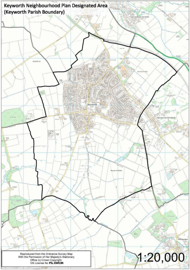
1.1 The government has financially supported over 200 ‘Frontrunner’ projects to help produce the first NDPs and provide guidance and insight for other communities and local authorities wishing to undertake their own. Keyworth Parish Council, as the qualifying body, won its bid to undertake a ‘Frontrunner’ project in 2011. The designated NDP area is Keyworth Parish. The parish council wished to ensure the Keyworth Neighbourhood Development Plan (KNDP) represented the wishes of the whole community and so established a Steering Group to facilitate the project and make recommendations on the content of the KNDP.
1.2 NDPs are to be shaped by the local community. The role of the steering group and parish council has been to act as facilitators in enabling local residents and representatives from the Rural Community Action Network (RCAN), Nottingham County Council and Rushcliffe Borough Council, to determine the focus of their NDP and devise policies to tackle local issues.
Status of the Neighbourhood Development Plan
1.3 Once adopted, the NDP will form a new tier of the Development Plan at the local level under the adopted Rushcliffe Local Plan (December 2014). It will be used to determine applications in accordance with the Planning and Compulsory Purchase Act 2004 Section 38 (6), in that the determination of planning applications ‘must be made in accordance with the Plan unless material considerations indicate otherwise’.
1.4 Neighbourhood Development Plans must be in conformity with the Local Planning Authority’s Development Plan. In the case of Keyworth parish this will be the Rushcliffe Local Plan. Part 1: Core Strategy. The first stage of consultation for Local Plan Part 2: Land and Planning Policies, was undertaken in early 2016 and once adopted will work alongside this Neighbourhood Plan and the Part 1 Local Plan.
1.5 The KNDP is a new tier of development plan policy and it will be used in the determination of planning applications within the parish boundary (see page 2 for boundary). It should be noted that this Neighbourhood Plan does not allocate any land adjacent to the village for development. Instead, a number of sites are recommended to Rushcliffe Borough Council for allocation in the Local Plan Part 2, which the Borough Council is currently preparing. These are the following sites:
- land north of Bunny Lane – recommended for housing development;
- land off Nicker Hill – recommended for housing development;
- land between Station Road and Platt Lane – recommended for housing development;
- land to the north of Debdale Lane – recommended as safeguarded land for potential future housing development; and
- land at Shelton Farm / Hill Top Farm, Platt Lane – recommended for employment development.
These recommended sites are set out in Appendix 3. It should be noted that, unlike the rest of the Neighbourhood Plan, Appendix 3 does not form part of the development plan, as defined by Section 38 of the Planning and Compulsory Purchase Act 2004. Accordingly, while these sites are identified on the Neighbourhood Plan’s Proposals Map, this is for illustrative purposes only.
It will be for the Borough Council and its Local Plan Part 2 to determine which, if any, of the recommended sites at Appendix 3 are ultimately allocated for development.
1.6 The KNDP has been prepared for the Keyworth parish community by the Keyworth parish community themselves. A series of consultation events and techniques has been used to gauge the community and key stakeholder’s hopes and aspirations for the future of the parish.
1.7 Rushcliffe Borough Council has meanwhile prepared a draft Local Plan Part 2 and Green Belt Review and carried out a consultation on them. That documentation and the comments received have also been taken into account in developing this plan.
1.8 A new Housing and Planning Act was approved in 2016 which may require the approach to affordable housing to be reviewed.
1.9 The table below provides a brief outline of the community consultation events held to date:
| Consultation Exercise | Date |
|---|---|
| Keyworth Village Plan – Consultation | July 2009 |
| Fresh Approach Consultation events – LPA Core Strategy | March - July 2011 |
| South Wolds School, Sixth Form Consultation event | October 2011 |
| Community Consultation SWOT Analysis (Site Selection Process) | April 201 |
| Community Questionnaire | April - September 2012 |
| Housing Sites Map comments sheet | April - September 2012 |
| Consultation with University of 3rd Age | May 2012 |
| Primary Schools Consultation | May 2012 |
| Drop-in Consultation at British Geological Survey | July 2012 |
| Digital Kiosk | July - September 2012 |
| Consultation with School Governors | Summer 2012 |
| Consultation with Keyworth Business Groups | January 2013 |
| Community Questionnaire | January 2013 |
| Main Statutory Body Response – Preliminary Consultation | May - June 2013 |
| Written submission from developers about their prospective development sites | June 2013 |
| Developer Presentations | February 2014 |
| Community consultation on developer schemes | April 2014 |
| Issues and Options Consultation with community at the Keyworth Show | July 2014 |
| Meeting with Keyworth Women’s Institute | September 2014 |
| Meeting with British Geological Survey | October 2014 |
| Regulation 14 consultation | December 2014 - January 2015 |
| Further consultation with statutory consultees (various) | April - August 2015 |
| Further engagement with Nottinghamshire County Council (highways representatives) | September 2015 |
| Engagement with key developers | November 2015 - January 2016 |
Development Strategies
1.10 The planning consultants assisting with the Plan (BPUD Ltd) analysed the results of the extensive consultation that had been carried out, presenting findings in a Consultation Report. The key results of this report and the findings of the Technical Baseline Report pointed clearly to a number of key issues which the community and key stakeholders felt the Neighbourhood Plan needed to address.
1.11 Throughout this project there have been two aspects to the preparation of the Keyworth NDP: the site specific detail, and the remainder of the key planning issues which the KNDP has the opportunity to address. These two elements are inextricably linked but have been formulated using slightly different methods. Key issues and supporting evidence have been gathered and policies dealing with each topic in turn, prepared. Site specific factors, in terms of the proposed allocation of residential and employment sites, were prepared through testing a series of options, details of which are given as part of Appendix 3. However, the proposed development
allocations identified at Appendix 3 are now only recommendations to Rushcliffe Borough Council and do not form part of the development plan. It will be for the Borough Council and its Local Plan Part 2 to determine which, if any, of the recommended sites at Appendix 3 are ultimately allocated for development.
1.12 The final development strategy brought forward by the KNDP, illustrated by the Proposals Map in Appendix 1, is a combination of Option 1a and 2, as set out in the original series of options. The Housing (H) and Economic Development (ED) policies set out the KNDP Development Strategy which will support the forthcoming allocation of sites as part of the Local Plan: Part 2. The preferred sites, which are supported and which in ideal circumstances would form part of that document, are set out in Appendix 3 of this document.
2. Background to the Parish
2.0 Keyworth village lies within the borough of Rushcliffe within the county of Nottinghamshire and is a large village with a population of roughly 7000 people. The village is surrounded by the Nottingham-Derby green belt. The borough lies in the south of Nottinghamshire, close to the border with Leicestershire, in the heart of the Midlands. The surrounding area is predominantly rural with a mixture of small towns and villages, with the nearest city being Nottingham, located 8 miles away to the north of Keyworth.
2.1 There is a significant retired population in Keyworth, with low numbers of young people and working age people. The high number of retired people in Keyworth accounts for a relatively low level of economic activity, but unemployment levels are low and overall Keyworth has a well-functioning economy and is considered highly sustainable in terms of provision of shops and services.
2.2 The population is generally highly skilled with high levels of educational attainment and qualifications. There are above average numbers of people who work from home and travel to work on foot. Keyworth has very low levels of deprivation (scored as the 28,411th least deprived neighbourhood out of 32,482 neighbourhoods nationwide) although this is considered to hide some pockets of deprivation.
3. Vision and Objectives
3.0 The community in Keyworth has developed a vision to guide the development of this Plan. All planning applications should be required to demonstrate how they have addressed the Vision as well as the policies and objectives which have been developed from it.
The Vision:
"To sustain a safe, friendly, inclusive environment in Keyworth"
3.1 The eight objectives set out overleaf, in no order of preference, aim to support the Keyworth Neighbourhood Development Plan vision. They have been produced with reference to consultation feedback provided by the residents of Keyworth and key stakeholders.
The objectives: Keyworth Neighbourhood Development Plan will aim to:
Objective 1 – Economic Development
Protect the existing businesses of Keyworth, whilst promoting new opportunities, specifically encouraging entrepreneurial activity and businesses in the high-skills, knowledge- based and tourist sectors.
Objective 2 – Community Facilities
Retain and enhance existing services and facilities whilst identifying opportunities to build on the village’s role as a rural hub through responding to local need.
Objective 3 – Leisure and Recreation
Improve the quantum and quality of, and access to, all types of recreation and leisure provision, including access to the countryside, for all ages and abilities.
Objective 4 – Shops and Retail
Retain, improve and promote retail opportunities within identified areas and encourage new, limited retail development to meet the needs of new housing schemes.
Objective 5 –Transport and Access
Reduce reliance on the private car by supporting proposals which encourage sustainable travel, including improvement and promotion of new and existing walking and cycling routes, and to deliver high quality targeted transport infrastructure improvements.
Objective 6 - Housing
Deliver 450 to 480 homes in order to meet the housing growth requirement for Keyworth up to 2028 whilst helping to create a sensitively designed and sustainable community.
Objective 7 - Environment
Protect and enhance environmental assets and biodiversity; supporting sustainable community led schemes and new development that relates well to the landscape and natural environment.
Objective 8 – Heritage and Conservation Area
Value and conserve the Keyworth Conservation Area and heritage assets through contextually responsive and sensitive design which reinforces Keyworth’s unique character.
4. Keyworth Neighbourhood Development Plan Overview
4.0 The following table demonstrates how all of the policies set out in the KNDP meet the objectives set out in Chapter 3. Generally, the policies address at least two objectives. However, there are some very specific policies intended to deliver targeted and specialist aspects of the objectives, which only address one.
Economic Development (ED)
ED1 – Major Employment Site
- Objective 1
- Objective 2
- Objective 5
- Objective 7
ED2 – Other Employment Schemes
- Objective 1
- Objective 2
- Objective 5
- Objective 8
ED3 – Entrepreneurial Enterprises
- Objective 1
- Objective 2
- Objective 5
- Objective 6
- Objective 8
Community Facilities (CF)
CF1 – Protection and Enhancement of Community Assets
- Objective 1
- Objective 2
- Objective 3
- Objective 5
- Objective 8
CF2 – New Community Facilities
- Objective 1
- Objective 2
- Objective 3
- Objective 6
- Objective 8
CF3 – Design of Community Buildings
- Objective 2
- Objective 3
- Objective 5
- Objective 6
- Objective 7
- Objective 8
Leisure and Recreation (LR)
LR1 (A) – Local Green Spaces; and L1(B) – Provision of New Open Spaces
- Objective 2
- Objective 3
- Objective 6
- Objective 7
- Objective 8
LR2 – Improved Pedestrian and Cycle Access
- Objective 1
- Objective 2
- Objective 3
- Objective 4
- Objective 5
- Objective 6
- Objective 7
Shops and Retail (SR)
SR1 – Active Retail Frontages
- Objective 1
- Objective 2
- Objective 4
- Objective 5
- Objective 6
- Objective 8
SR2 – Public Realm Strategy for Retail Areas
- Objective 1
- Objective 4
- Objective 5
- Objective 7
- Objective 8
SR3 – Design of Shop Fronts
- Objective 1
- Objective 2
- Objective 4
- Objective 7
- Objective 8
Transport and Access (TA)
TA1 – Sustainable Modes
- Objective 1
- Objective 2
- Objective 3
- Objective 4
- Objective 5
- Objective 6
- Objective 7
- Objective 8
TA2 – Highways and Access
- Objective 1
- Objective 2
- Objective 3
- Objective 5
TA3 – Parking Standards
- Objective 5
- Objective 6
Housing (H)
H1 – Housing Strategy
- Objective 2
- Objective 3
- Objective 4
- Objective 5
- Objective 6
- Objective 7
H2 – Type and Tenure
- Objective 6
H3 – Design Requirements for New Development
- Objective 5
- Objective 6
- Objective 7
- Objective 8
Environment (E)
E1 – Green and Blue Infrastructure
- Objective 2
- Objective 3
- Objective 7
- Objective 8
E2 – Protection of the Environment
- Objective 3
- Objective 6
- Objective 7
- Objective 8
Heritage and Conservation (HC)
HC1 – Public Realm (Within the Conservation Area)
- Objective 4
- Objective 7
- Objective 8
HC2 – Conservation Area Building Design
- Objective 2
- Objective 4
- Objective 8
HC3 – Key Views
- Objective 2
- Objective 7
- Objective 8
HC4 – Heritage Assets
- Objective 8
5. Economic Development
Policy ED1 - Major Employment Site
5.0 The British Geological Survey (BGS) premises is a site of scientific excellence which has forged strong links with the community and is a significant employer within Keyworth. The BGS is identified on the KNDP proposal map as a major employment site. Its continued growth and operation here is not only important to the area’s economic activity and wealth but also to the community’s identity and overall vision for the future.
Policy ED1 - Major Employment Site
New development or redevelopment of buildings at the BGS site (as shown on the proposals map) which supports existing and future operations (in use classes B1a-c or ancillary activities in other use classes) will be supported.
Additionally, proposals for limited infilling within the BGS complex for uses other than those set out above and for any other ancillary uses will be supported.
Where appropriate new development will be required to meet the following criteria:
- Being of a scale appropriate to that of the existing complex.
- Not exceeding the height of the tallest existing building on the complex.
- The nature and appearance of the existing parkland is to be retained at all times unless a landscape assessment supports appropriate mitigation and enhancement proposals.
- Not conflicting with other policies of the KNDP or the Rushcliffe Local Plan.
Development proposals which would result in a net loss of employment space in use classes B1a-c, either by demolition or a change of use, will be resisted unless supported by adequate justification.
Where a loss is justifiable, development proposing creation of employment opportunities (use classes B1a-c only) will be considered preferable to other uses.
Explanatory
5.1 This policy encourages development at the BGS site which safeguards existing employment opportunities and supports continued growth of site operations, thereby responding to the government’s need to promote economic growth. It provides opportunities to support activities relating to the BGS, and also supports diversification of activities on the site.
5.2 This policy encourages the establishment of a hub for small and medium scientific enterprises, which support and/or complement ongoing BGS activities to create an environment which promotes the sharing of business ideas and drives scientific development and achievement. This is supported by the BGS which is seeking to diversify and make better use of their asset.
5.3 Located on the edge of the green belt, it is essential to balance the design and extent of future development with the rural nature of the landscape, specifically in the east. It is therefore critical that the site does not become over developed. Development proposals should be informed by: relevant sections of the landscape analysis (PGLA) which has informed the production of the KNDP and provides part of the evidence base, the National Area Character Profile within which Keyworth falls, and other relevant authority landscape assessments, in order to design buildings which are appropriate within the parkland and are not incongruous when viewed from the surrounding countryside.
5.4 The KNDP encourages development which enhances the existing park landscape character, specifically through the planting of native trees to screen proposed development where desirable.
5.5 In addition, the Keyworth Neighbourhood Development Plan supports proposals for employment purposes on a small allocation of land to the north-east of the BGS site. This utilises land which is a mixture of a current farmstead and outbuildings and an area of previously developed land used for informal storage. This site has been put forward to Rushcliffe Borough Council as part of their ongoing allocations process which will result in the Local Plan: Part 2. Only a local plan can take land out of the green belt. It is envisaged that this new employment site adjacent to the BGS site, would allow for sensible expansion of employment opportunities in
Keyworth. A formal allocation would be made under the Local Plan: Part 2. Full details are provided at Appendix 3.
Policy ED2 Other Employment Scheme
5.6 Whilst the previous policy addressed the possibility of larger scale employment and commercial growth at the BGS site, there will undoubtedly be a great number of smaller schemes which occur throughout the parish over the Plan period. These often take the form of conversions of existing buildings, farm diversification and redevelopment of existing employment sites, such as the Debdale Lane Trading Estate. This policy seeks to support this diversification and redevelopment without harming local amenity. The community considered it was important to ensure the preservation of existing employment uses within the parish. The community highly values opportunities to live and work in Keyworth and care must be taken to limit any loss of existing employment facilities. This policy sets the criteria against which the loss of existing facilities should be tested.
Policy ED2 Other Employment Scheme
Outside the major employment site and the allocated sites, planning permission will be supported for B1a-c employment use where it contributes to the economic diversification of Keyworth and where it can be demonstrated that:
- It is of a suitable scale and the character and appearance of the surrounding area will be
preserved - Visual and residential amenity will be preserved
- The development will not have an unacceptable cumulative adverse impact on highway capacity and safety
- Appropriate car parking will be provided
- The proposal will not conflict with other policies of the KNDP or Rushcliffe Local Plan.
Within the Green Belt planning permission will not be supported for inappropriate development harmful to the Green Belt unless very special circumstances can be demonstrated.
Where a building is used for existing employment use, its conversion to a non-employment use or, where relevant, its redevelopment, will be resisted unless it can be demonstrated reasonable attempts have been made to secure an employment use or its continued employment use is no longer viable.
Explanatory
5.7 The above policy seeks to encourage small scale employment development, restricted to that which is appropriate within the predominantly residential area of Keyworth and its surrounding countryside. It also puts in place checks to ensure that neighbouring amenity is not compromised, in line with local and national planning policy. By restricting the economic development within the green belt to those uses commensurate with the green belt designation, this allows the principle focus of development to be placed upon the built up area of Keyworth, and to a lesser extent the urban areas of the Nottingham conurbation. It also further enhances its overall sustainability and viability, allowing businesses to make use of the existing transport links, services and shops within the settlement.
5.8 Medium and large scale employment activities outside the settlement and the industrial estate at Debdale Lane, are unlikely to be acceptable unless they can demonstrate a specific locational need.
Policy ED3 - Entrepreneurial Enterprises
5.9 The KNDP supports economic development and the benefits derived by the community from its delivery. This policy encourages facilities which enable sole-traders and start-up companies to prosper within Keyworth. These are often set up as ancillary units to residential dwelling houses and therefore are predominantly in residential areas. Consequently, the potential for conflict means that careful controls on economic activity in residential areas are required.
5.10 Tourism uses, such as bed and breakfasts and holiday lets, are also considered to help contribute to the overall economic diversity of the parish. The community wishes to support tourism uses such as these, which are also often in existing residential houses. In many cases this does not involve operational development, only a change of use which would necessitate planning permission being sought.
Policy ED3 - Entrepreneurial Enterprises
Planning permission for the conversion of residential dwelling houses, residential garages, or similar curtilage buildings (and the operational development reasonably necessary) for business or tourism uses, will be supported provided that, where appropriate, all the following criteria are met:
- The use of the building will not be a bad neighbour use
- Amenity of neighbouring occupants, including visual amenity, will be preserved
- Development will be acceptable in highways terms and sufficient parking is provided for the proposed use, in line with other development plan policies
- The conversion and use of buildings for business/tourism use will be acceptable in all other respects
- The proposal will not conflict with other policies of the KNDP or the Rushcliffe Local Plan.
In addition, proposals for the conversion of rural buildings or farmsteads to create employment opportunities will be supported by the KNDP, subject to accordance with the above relevant criteria. New residential schemes which provide or support opportunities to work from home will be encouraged.
Explanatory
5.11 The KNDP encourages entrepreneurial activity within Keyworth, and will support within the Plan area development proposals which deliver the facilities and services which enable sole-traders and start-up companies to work from home, or which support existing or new tourist facilities.
5.12 The provision of new business premises can be an affordable means by which to develop and grow new start-up businesses and support the economic objectives of the Local Plan. However, such development may have unintended consequences. This policy provides specific criteria to avoid adverse harm. Development which adversely impacts neighbouring amenity in terms of noise, hours of operation, traffic generation and visual impact, will be resisted.
5.13 New residential schemes which support the objectives of this policy will be encouraged; for example, through the inclusion of standalone garden office space, provision of flexible residential accommodation or the provision of suitable facilities by adding to any design additional plug sockets or broadband and networking infrastructure.
5.14 Encouraging sustainable tourism to Keyworth has the potential to provide significant benefits in terms of the inward investment it attracts to the village, and the opportunities it provides individuals to establish small-scale tourist services, such as B&Bs. In this regard the KNDP supports improvements to existing and provision of new tourism infrastructure, and to improve the tourist economy of Keyworth.
6. Community Facilities
Policy CF1 - Protection and Enhancement of Community Facilities
6.0 Community facilities such as schools, health facilities and even public houses are important in encouraging social interaction between members of the local community, encouraging wellbeing and creating the overall social capital within Keyworth. The preservation and enhancement of these types of facilities is important in building a strong and sustainable community for the retention and enhancement of community assets.
Policy CF1 - Protection and Enhancement of Community Facilities
Development which results in the improvement of the following community assets, in terms of overall capacity and the breadth of services, will be supported:
- Schools (Keyworth Primary and Nursery School, Crossdale Drive Primary School, South Wolds Academy and Sixth Form)
- Pubs (Keyworth Tavern, Fairway; Salutation, Main Street; Plough, Selby Lane; The Pear Tree, Nottingham Road)
- Health Centre (Bunny Lane)
- Leisure Centre (Bunny Lane)
- Village Hall Complex (Elm Avenue)
- Allotment (Willow Brook / Widmerpool Lane)
- Churches (Keyworth Baptist Church, Nottingham Road; Keyworth Methodist Church, Selby Lane; United Reform Church, Nottingham Road; St Mary Magdalene, Nottingham Road)
- Library (Church Drive)
- Leisure Centre and swimming pool (Church Drive)
- Rectory Field and Bowls, Tennis Clubs
- Platt Lane Playing Fields and pavilions
- Keyworth Meadow Nature Reserve
Development which would result in the loss of any of the above assets will be resisted, unless:
- The asset would be replaced by equivalent or superior provision in a suitable location, as agreed through negotiation between Rushcliffe BC and the developer, or
- If it can be demonstrated that there is no longer any need for the facility or that it is financially unviable.
Explanatory
6.1. It is recognised that Keyworth has numerous services and facilities which together assist in shaping the sustainable community of Keyworth. Nevertheless, these assets are vulnerable to economic pressure, change of use and/or redevelopment. This policy therefore seeks to recognise their importance. There is a presumption in favour of their retention. Proposals for their enhancement will be supported.
6.2. This policy sets out the broad targets for maintaining and supporting the current levels of community assets within the parish. Keyworth has a wide variety of excellent facilities which partly account for its ability to accommodate development in both housing and employment terms. It is vitally important that these facilities remain viable and protected, and that they are enhanced to further accommodate growth supported by the planning system.
6.3. Importantly, this policy adds in protection against the removal or loss of community facilities (and that may include the loss of a certain element within an existing building or complex). The onus is therefore on the applicant to demonstrate why the facility is either no longer needed or to ensure that there is a process for its replacement elsewhere. This can be done through the use of legal agreements.
6.4. The parish council welcomes any discussions with applicants at either the application or pre-application stage to help shape the future of local community facilities
Policy CF2 - New Community Facilities
6.5 Notwithstanding the excellent range of facilities protected under policy CF1, there remain facilities which the community would still like to see delivered. This policy seeks to ensure their delivery through removing planning barriers, or to support developers delivering them alongside other proposals for housing and employment.
Policy CF2 - New Community Facilities
New development proposing to deliver the following new community assets will be looked on favourably:
- Adult Education Centre
- Indoor Leisure facilities
Where possible these should be in the form of multi-use spaces, combined with existing facilities and services that allow for multiple uses. In developing proposals for new community facilities, early engagement with the community, the parish council and other local interest groups is encouraged.
Contributions may be sought from all strategic residential schemes (as set out in policy H1) for the delivery of these assets where proposals for their delivery have been identified, where it is necessary to mitigate the impacts of development, and provided that the viability of the development proposals are given consideration.
Explanatory
6.6 In order to develop social capital within the neighbourhood it is important that the Plan strives to deliver a greater range of activities for the community. Adult education is important to help the overall educational attainment of the population. Many of the residents are within the professional sector and therefore continued professional development as well as social (night school) courses are seen as important to delivering a higher quality of life.
6.7 Whilst the leisure centre at Keyworth offers a range of facilities, there is a limit on the indoor sports provision. Currently there are no squash courts and only a single multi-use gymnasium, limiting the number and range of activities that can be offered at any one time. Additional gymnasiums and specialist courts are sought by the community, made clear from the consultation undertaken during the development of this Neighbourhood Plan. Where feasible, to enable new community facilities to be utilised effectively by a broad spectrum of the community, buildings must be designed to provide flexibility of use. In addition, the Keyworth swimming pool is a smaller 20m sized pool with additional learner pool. More extensive use of the pools could be supported by longer opening hours.
6.8 Given the increased pressure placed on the leisure centre and the other sports and leisure facilities within Keyworth caused by new residential development, contributions will be sought to assist in funding these improvements. Offering these facilities locally, within walking and cycling distance, means that the need to travel is reduced, improving the overall social sustainability of the community.
Policy CF3 - Design of Community Buildings
6.9 Well-designed development is critical to the establishment of sustainable communities. It is expected that all new development should positively contribute to the built environment. Development should respond in an environmentally and locally responsive manner. Examples exist within Keyworth of community assets which have not been sympathetically designed and impact negatively upon the street scene or are incongruous within the wider landscape. The design of new community assets must be of the highest order to set a design standard within the parish.
Policy CF3 - Design of Community Buildings
Planning permission will be granted for new or improved community buildings, where it can be demonstrated they will appropriately address the following aspects:
- Development layout takes into consideration its relationship with the immediate and wider environment and traditional settlement patterns, and protected views.
- The development provides equal access to everyone.
- Where relevant, design should be contextually responsive. Flexibility may be given for proposals that achieve an exceptional standard of design quality.
- Neighbouring residential amenity must be preserved at all times, in terms of space, light and overbearing.
- Where relevant, landscape schemes should seek to include native species of tree and plants.
- Material selections should be complementary to one another and to the wider built environment.
- Parking provision within new proposals should be proportionate to the scale and function of development.
Proposals which include low carbon or carbon-neutral buildings and achieve decentralisation of energy production will be supported, subject to avoiding appearing incongruous or visually prominent within the wider landscape. This should not preclude high quality, innovative design. Where appropriate, community buildings should be subject to a design review.
Explanatory
6.10 The community of Keyworth has recognised a number of community buildings which exhibited poor design, including the new medical centre at the heart of the village. This policy places the design of new development at the forefront of the determination process and provides a baseline which must inform all future development, where relevant.
6.11 It is expected that new development will consider the relevance of design and be contextually responsive to the wider environment. Notwithstanding this, the policy does not seek to promote only a vernacular design approach; new design techniques and material choice which benefits the immediate and wider environment will be supported.
6.12 The policy also identifies the importance of ensuring the buildings reflect long term sustainable criteria, in an appropriate and attractive style and seeking to embrace low / zero carbon design solutions. This does not preclude innovative contemporary design, but ensures that designs have been carefully considered to ensure that they sit comfortably within the fabric of the built environment.
7. Leisure and Recreation
Policy LR1(A) - Local Green Spaces and Policy LR1(B) - Provision of New Open Spaces
7.0 These two policies seek to ensure that all residents have ready access to existing open space provision within the urban area of Keyworth and its surrounding countryside. Additional demand for open space provision has been identified (Rushcliffe Borough Council Open Space Audit, 2010) and therefore the KNDP encourages new provision to meet this requirement. This is especially pertinent in light of the residential development allocated by the KNDP over its Plan period.
Policy LR1(A) - Local Green Spaces
Existing open spaces and formal and informal open spaces, listed below and defined on the Proposals Map, will be designated as Local Green Spaces and protected from inappropriate development:
- footpath and woodland off Platt Lane;
- skate park off Platt Lane;
- triangular playing field behind houses on Plantation Road and Croft Road;
- Rectory Field and Bowls, Tennis Clubs;
- Platt Lane Playing Fields.
Development resulting in the loss of Local Green Space will be resisted unless there are exceptional circumstances justifying its loss and/or the applicant provides equivalent or better provision elsewhere, in terms of its quality and quantum, and which is equally accessible to the community.
Policy LR1(B) - Provision of New Open Spaces
The following provision of open space will be sought in respect of new development:
- Where new residential development above 25 units is proposed, suitable provision for formal and informal open space should be made in accordance with the standards set down by the RBC Leisure Facilities Strategy and Playing Pitch Strategy (or any subsequent strategy);
• All new commercial office space should be provided with adequate outdoor areas for the enjoyment of occupiers and to ensure the landscape is not dominated by car parking areas;
• Development will be supported which contributes to the creation of a green trail network that has been identified by the Parish Council and which is viable and deliverable. New provision should provide links to the existing green networks and existing or proposed public green spaces. Contributions may be sought towards the long term management of provision on land over which the developer has control.
Explanatory
7.1 The Plan is clear that the protection of existing green spaces is a priority, although it makes provision of leisure development on these to be converted to indoor leisure in support of the Community facilities policies. Given the documented shortage of recreation and open space and children’s play facilities, any loss must result in a replacement facility that can be easily accessed by the community.
7.2 The policy also sets the standards for new residential development and its provision within new developments. These standards are set in relation to the standards set out in the RBC Leisure Facilities Strategy which has been used as the determining factor of ensuring adequate outdoor formal and informal open space since its adoption in 2006. Formal children’s play may take the form of either one single space or disaggregated to allow it to be more easily accessible to all.
7.3 The Plan encourages the formation of a new network of green spaces and trails, responding directly to hierarchical planning policy and guidance which seeks to promote the health benefits associated with outdoor leisure activities. The community has highlighted the importance of making the most of surrounding countryside assets; consequently, improving access to these is seen as an alternative to new provision.
7.4 The creation of a green trail network, providing and encouraging access throughout Keyworth and its surrounding landscape, for the benefit of the local community is an aspiration of the Parish Council. Therefore, it is proposed that development which makes a contribution towards the achievement of the network, using up to 50% of the required provision of open space in the standard set out in the Policy, will be supported subject to it meeting the requirements of other relevant policies in the Local Development Plan.
Policy LR2 - Improved Pedestrian and Cycle Access
7.5 The health benefits of utilising walking and cycle ways are well recognised and the planning system should make every effort to support these. Supporting sustainable transport modes is a key aspect of this Neighbourhood Plan and new development should ensure that it makes a reasonable contribution to this, linking new residential and commercial development to health, education, recreation and leisure opportunities throughout the settlement.
7.6 There is currently a documented under provision of these routes within the Keyworth area. Many of the existing routes are poorly surfaced and are secluded, not benefitting from homes overlooking the route, which makes them unattractive for pedestrians. It is important that new routes link to existing routes. The Plan aims to create safe, well lit, off road routes.
Policy LR2 - Improved Pedestrian and Cycle Access
Proposals which seek to improve existing pedestrian and cycle networks within the Plan area will be supported. Development proposals which will result in the loss of existing provision will be resisted.
Proposed residential and commercial development should seek to deliver new walking and cycling routes, specifically where there are no or limited routes between existing and future community assets (as set out in Policy CF1) and bus stops. Where it is necessary to mitigate the impact of new development and subject to viability consideration, contributions may be sought to ensure that these routes are delivered.
Explanatory
7.7 Preservation of existing and creation of new pedestrian and cycle networks will provide a sustainable means by which residents of Keyworth can travel throughout the settlement and accordingly reduce the need to use the private car. Such networks provide a safe, alternative to travelling on the highway network to recreational areas and places of interest.
7.8 When considering possible new network routes, developers should have regard to the location of the community assets set out in policy CF1 and link to them. The parish council and Rushcliffe Borough Council will enter into negotiation with local developers to ensure that appropriate, high quality routes are delivered which are not detrimental to the free-flow of existing traffic provision and retained in perpetuity.
8. Shops and Retail
Policy SR1 - Active Retail Frontages
8.0 Keyworth is designated a Key Settlement within the Rushcliffe Borough Council Local Plan and well serviced. Three shopping areas exist within it; Keyworth Square (Main Street), the precinct on Wolds Drive, including Budgens, and a smaller collection of shops at the junction of Debdale Lane and Nottingham Road. The community highly values these shopping areas and wants to protect and reinforce their role by encouraging their clustering and by resisting retail development outside the identified retail areas.
Policy SR1 - Active Retail Frontages
The Neighbourhood Plan identifies three key shopping areas within Keyworth, as noted on the Proposals Map. These include two Local Centres at The Square and Wolds Drive and an area on Nottingham Road / Debdale Lane identified as an Area of Neighbourhood Importance. The final boundaries of these areas will be defined by the Local Plan: Part 2.
Retail development (use classes A1 -A5) in excess of 75sq/m (gross) outside these designated shopping areas will be resisted, unless as part of a large residential development where convenience retail can be provided to meet an identified localised need arising from new
development.
Within these areas development proposals in Use Classes A1-A4 is encouraged, particularly those which achieve a strong active frontage during the day. Planning applications (including changes of use) that will result in a significant portion of the frontage being unused in the daytime will be resisted, unless it can be demonstrated that the scheme is necessary to maintain vitality and viability of the shopping area.
Proposed changes of use from retail to residential within the identified retail areas will be resisted where the retail premises form part of an active shopping frontage. Applications for offices (B1a) ‘above shop living’ and mixed use buildings will be supported within the retail areas, where they maintain an active ground floor non-residential use within the frontage.
Explanatory
8.1 The Local Plan: Part 1 identifies the retail areas at the Square and at Wolds Drive as being the focus for shopping in Keyworth. In addition, the Neighbourhood Plan identifies the cluster of shops and services at Nottingham Road as being of importance to the local neighbourhood. The Local Plan: Part 2 will set the extent of the retail areas within the settlement and define shopping frontages, including formally designating areas of Neighbourhood Importance for areas such as Nottingham Road. This policy seeks to ensure that new and existing shopping uses are focused towards these areas and supported by the designations in the Local Plan: Part 2.
8.2 The role of these shopping areas, in particular the primary area, the Square, is reinforced through the concentration of retail and associated uses should they exceed the size of a typical corner shop. Furthermore, it allows for the impacts of retail areas (parking, deliveries, litter and neighbour amenity) to be focused and controlled effectively.
8.3 It is hoped by focusing retail within these key frontages, the vitality and viability of these areas can be sustainably maintained. However, for larger allocated housing sites, a smaller convenience retail use may be appropriate to ensure that more of the community has access to local shopping facilities.
8.4 Within the retail frontages, residential development will be resisted, unless it is in the form of a flat above a unit or part of another mixed use scheme. Flats / apartments above shops are considered not to detract from the retail area and in fact add to the vitality and vibrancy of such centres and make best use of land.
8.5 Retail uses within the Use Classes A1 – A5 (shops, cafes, hairdressers and Hot Food Takeaway) are permitted.
Policy SR2 - Public Realm Strategy For Retail Areas
8.6 The Keyworth Conservation Area Appraisal and Management Plan (2010) identifies the appearance of unsympathetic shop fronts, street furniture and hard landscaping in The Square area as a key weakness within Keyworth. Whilst the other retail areas are not within the Conservation Area they too are considered by residents, to be making a poor contribution to the settlement as a whole.
8.7 Keyworth’s retail areas are therefore in need of environmental improvements both aesthetically and in terms of their functionality (such as parking and deliveries) and also in their effectiveness in serving the community. This includes improved access for all, making retail areas attractive to consumers and to business investment. The overall aim of this policy is to seek contributions from developments to deliver environmental improvements for the benefit of residents and businesses and to secure their long term vitality and vibrancy.
Policy SR2 - Public Realm Strategy For Retail Areas
A Public Realm Strategy is proposed, setting out desirable improvements within the Policy SR1 shopping areas, focusing on the delivery of the following elements:
- Shared surfaces and crossings, where appropriate;
- Improved parking provision, in particular short stay;
Improved accessibility including disabled bays, ramped access to shops and additional seating areas.
Developments or community led projects which seek to provide or contribute to the improvements proposed by the Public Realm Strategy will be supported, subject to compliance with all other policies within the Development Plan. Where such developments affect the Conservation Area, they will be subject to compliance with policies HC1-HC4 (Heritage and Conservation) and Policy 11 in the Rushcliffe Local Plan Part1.
Contributions towards achieving elements of the Public Realm Strategy through specific schemes may be sought, where appropriate and subject to negotiation and viability considerations, from developments on allocated sites, and those providing more than 10 residential units or 500 square metres of commercial floorspace.
Landscape schemes associated with the improvements should use an appropriate and robust palette of materials and planting, including the use of natural stone. The incorporation of forecourts, allowing retail uses to spill out and create an active street scene will be encouraged.
Explanatory
8.8 This policy focuses on making the retail areas more attractive, visible and viable through delivery of public realm improvements. The aim is to create spaces in which people want to spend time, visit and invest. The policy details how retail units can offer an improved active retail frontage. Contributions may be sought to cover the cost of survey and overall design, in addition to physical delivery. The retail uses are important for both local residents and people working in Keyworth and as such appropriate contributions should be negotiated by the LPA in consultation with the parish council.
8.9 The Public Realm strategy set out in the policy should look to improve the quality and durability of surfaces, improve shop fronts (policy SR3) and shop forecourts and introduce more attractive seating areas, whilst addressing parking and surfacing. This will be achieved through improved short stay parking, disabled parking and general accessibility of the shops and seating areas, such as removing any unnecessary changes in levels.
8.10 The design of shop fronts is dealt with specifically by policy SR4. Further guidance on the public realm within the Conservation Area (some of which is designated as retail frontage) is contained in policy CF1 and HC1 - HC4.
Policy SR3 - Design of Shop Fronts
8.11 Good shop front design promotes not only the individual shop but also contributes to its location and raises the quality of the street. Policy SR4 deals specifically with the design of shop fronts within the retail areas in Keyworth. It not only covers shops and retail within the identified shopping frontages (SP1) but also those outside these areas. Some of this guidance will also be relevant to applications for advertisement consent if they are of a scale and type not allowed by permitted development.
8.12 The Keyworth Conservation Area Appraisal and Management Plan (2010) identifies the appearance of unsympathetic shop fronts as a key weakness within Keyworth Square. However, evidence suggests that the other remaining retail areas are suffering from similar issues of poor shop front design. This policy sets out criteria which new and existing shops should follow in order to comply with best practice to improve the overall aesthetic appearance of these areas.
Policy SR3 - Design of Shop Fronts
Where planning permission is required for the refurbishment or replacement of existing shop frontages and installation of new shop fronts (as part of new development proposals), applicants must demonstrate how they have considered and addressed the following design criteria:
Consideration of the architectural styles of adjoining buildings and shop fronts and the wider street scene.
- Fascias should: be of a scale proportionate to the rest of the building; not obscure windows and other architectural detailing; align with other fascias in the parade. Box fascias and box lighting will not normally be permitted.
- The subdivision and proportions of windows should relate to the character of the building and its neighbours.
- Signage should respect the character of the individual building and adjoining properties. Only one hanging sign will be permitted per shopfront.
- In all circumstances solid shutters are unacceptable. Only security measures which maintain a level of transparency to and from the street will be permitted, such as laminated glazing, lattice grilles and perforated shutters.
- Within the Conservation Area projecting boxes and external shutters are also inappropriate and will be resisted.
Explanatory
8.13 This policy seeks best practice in new and existing shop fronts by making sure retail units interact well with and make a positive contribution towards the street scene. This is achieved via the set of criteria which should be used to guide the specific design of shop fronts. These criteria deal with transparency, proportion, activity and consistency in shop front design.
8.14 .Shutters and other security measures are often the cause of inappropriately scaled and designed shop fronts and therefore solid shutters and external shutters will be resisted within the Conservation Area.
8.15 The Keyworth Square retail area is predominantly within the Keyworth Conservation Area and is therefore subject to additional restrictions to ensure that shop front design enhances and preserves the setting of listed buildings and heritage assets in accordance with other policies within the Plan.
9. Transport and Access
Policy TA1 - Sustainable Modes
9.0 Keyworth is a highly sustainable settlement and the NDP seeks to further promote and expand sustainable modes of transport and high quality design which offers people real choice and has benefits for health and wellbeing as well as wider environmental issues.
9.1 The NDP supports the creation of an integrated transport network (including footpaths and cycle ways), enhancing interchange between key modes and enhancing Keyworth’s role as a ‘rural hub’ for both transport and for local shops and services.
Policy TA1 - Sustainable Modes
All new residential development should be located to take advantage of existing services and facilities (as outlined in policy CF1) as well as being within easy walking distance (400m) of a bus route. Transport Assessments supporting planning applications should consider how they intend to provide new, or where appropriate improve existing, connections and encourage their use through good design.
The size and type of new developments will determine the type of transportation assessment that is required, and whether a travel plan is necessary. The thresholds for these requirements are set out in guidance published by the Government and by the local transport authority. Where applicants are required to prepare and implement travel plans, they should demonstrate how the scheme proactively seeks to encourage residents and workers to choose sustainable alternative modes to the car when accessing employment opportunities, key services and facilities.
Explanatory
9.2 This policy seeks a commitment from developers to provide those using their sites real options to use sustainable transport rather than rely on the private car. This means, ensuring they are within realistic walking distances for the majority of people and proximity to public transport, walking and cycling routes. Some of this policy supports the hard infrastructure necessary to support policy LR2.
9.3 It is recommended that all new residential development is placed within 400m of a bus route. 400m is defined within ‘By Design’ and the ‘Urban Design Compendium’ as the maximum distance that can be considered reasonable to expect residents to walk to services and facilities.
9.4 Larger schemes are required to prepare travel plans (as set out in the DfT publication Guidance on Transportation Assessments (2007) and within the NCC Guidance on the Preparation of Travel Plans (2010)) to encourage people to use sustainable modes of travel. This is important in reducing the number of cars that may be used at peak hours. These should be implemented to ensure that where possible day-to-day travel patterns are changed so as not rely so heavily on the private car. This should be undertaken in parallel with including the infrastructure to support sustainable transport, such as improved bus waiting facilities and new safe cycle storage at bus
termini, and that safe footpaths link these facilities with employment, leisure and retail opportunities.
Policy TA2 - Highways and Access
9.5 Highways safety is a key aspect of delivering sustainable development. The impact of new development on the highways network in Keyworth has been a key concern for many residents and businesses operating within the settlement. In addition to ensuring that overall highways safety is accommodated within new development, certain highways junctions have consistently been the cause of concern. The policy seeks to target intervention on these.
Policy TA2 - Highways and Access
All new development should ensure that it includes suitable measures to accommodate traffic entering and leaving the development, and contribute to improving the overall safety and attractiveness of the highways network.
When designing highways interventions, applicants should consider the implications of changing lifestyle patterns, accommodating vehicles such as grocery delivery vans, removals vehicles and other HGV deliveries. The collection of rubbish and recycling should also be considered.
Where necessary to mitigate the impact of new developments (residential and non-residential), and subject to viability considerations, contributions will be sought towards the following improvements:
- Carriageway and crossing improvements to Platt Lane including the delivery of appropriate safe footpaths on either side of the road.
- Improvements to the junction of Platt Lane, Nicker Hill, Normanton Lane and Station Road to reduce speeds and increase visibility.
- Enhancement to the junction of Nottingham Road and Debdale Lane to improve access for larger vehicles and to enhance the pedestrian environment.
- Gateways into the settlement, including speed reduction treatment (not including carriageway narrowing (pinch points) or speed humps, which interrupt the free flow of traffic), at Bunny Lane, Station Road, Platt Lane, Stanton Lane, Selby Lane and Wysall Lane.
Contributions will only be sought for improvements where a specific scheme has been identified by the appropriate statutory body.
Explanatory
9.6 This policy introduced the tests for assessing the acceptability of highways schemes with new developments. The final decision on these matters will rest with the highways authority (Notts. CC), however, the policy ensures they consider the appropriate factors when considering the highways impact of new development.
9.7 In addition, it is evident that there is a requirement for off-site highways works to accommodate the growth in traffic which will in the main, leave the village to the north along Station Road and Platt Lane. This will result in improvements to these routes, highlighting highways and pedestrian safety and contributions will be required from the allocated sites to deliver these where appropriate. A strong focus on the Platt Lane, Nicker Hill, and Station road area of the network is highlighted since a good deal of the commercial and residential development is placed in and around this area, and it is anticipated that up to 65% of the traffic generated by any site will leave in the direction of the A606 / A52 (see P10 highways assessment of sites and traffic).
Policy TA3 - Parking Standards
9.8 Parking and the impacts of parking on surrounding neighbourhoods need to be carefully considered as part of a new development. Insufficient parking causes overspill into streets surrounding a neighbourhood, adds to highways safety issues and delivers unattractively designed neighbourhoods. Residential development has very specific parking requirements (for residents and visitors), although commercial and retail development is considerably more complex with a number of variables determining the acceptable number of spaces.
Policy TA3 - Parking Standards
The following on-site parking standards are sought for new market residential development providing more than 10 dwellings:
- For dwellings of 3 bedrooms or fewer – a minimum of 2 spaces to be provided
- For dwellings of 4 bedrooms or more – a minimum of 3 spaces are to be provided
- Include appropriate parking and safe storage of up to 2 bicycles
Visitor parking should be provided at a rate of 1 space for every four dwellings proposed and parking needs should be met within the confines of the site.
Affordable housing schemes should demonstrate that sufficient car parking has been provided on site for occupiers and visitors. Developers will be encouraged to provide garages of a scale to accommodate modern larger vehicles.
Proposals for schemes of 10 or less dwellings or for non-residential development, or for all development within the Conservation Area, should demonstrate an appropriate level of parking based on consideration of the following, and may be provided by way of improvements to existing public car parking facilities:
- Accessibility and location
- Type of development
- Availability of public transport
- Likely peak time number of visitors and local employees
- Local car ownership levels
Explanatory
9.9 The community has been increasingly concerned about the impact of parking from any new development on surrounding streets and neighbourhoods. The policy seeks to address this concern and ensure that parking for any new development is provided comfortably within any given development. A wide range of parking types should be provided including; off street, on-plot, and garaging and should be fully integrated with the design for the overall site. Suitable provision within the streets and spaces of a proposed development may also be considered acceptable subject to ensuring that it does not impact negatively on the street scene.
9.10 .The standards for residential development are based on the numbers of cars associated with larger households, many having more than two vehicles. If the intention is to increase the use of public transport, these vehicles need to be safely and conveniently stored within the development during the day and overnight.
9.11 All new development will be expected to be delivered to set parking standards, or contribute to the delivery of new car parking as part of the identified shopping areas where this is appropriate. The criteria set for non-residential development, and the determination of appropriate parking numbers, have been adapted from national guidance in the NPPF.
10. Housing
Policy H1 - Housing Strategy
10.0 The Rushcliffe Borough Local Plan overall housing strategy (Policy 2) seeks the provision of a minimum of 450 residential dwellings in or adjacent to Keyworth in addition to those already identified as being within the existing settlement boundary (identified in the 2013 SHLAA). Keyworth is defined as a Key Settlement given its range of shops and services and regular public transport connections. Following careful consideration of the available sites, their impact on traffic generation, the Green Belt and the landscape character, and responding to the community consultation, the Neighbourhood Plan recommends to Rushcliffe Borough Council for potential inclusion in its Local Plan Part 2 an aspirational housing strategy which has been developed and which seeks the allocation of 450 to 480 dwellings across three sites. A further site is recommended as safeguarded land for future development should the allocated sites not come forward, or to meet need during the next Plan period totalling another 200 dwellings. Full details of this aspirational strategy is included in Appendix 3. The development strategy is a recommendation to the Borough Council and, therefore, it and Appendix 3 as a whole, does not form part of the development plan. It will be for the Borough Council and its Local Plan Part 2 to determine which, if any, of the recommended sites at Appendix 3 are ultimately allocated for development.
10.1 The Neighbourhood Plan is unable to specifically allocate sites for housing, as this would mean releasing land from the green belt designation – something that only the Local Planning Authority can do through a Local Plan process. However, in arriving at the Neighbourhood Plan Strategy and the policies which are contained within, a considerable amount of consultation and engagement has indicated a prepared housing strategy and preferred sites.
10.2 The choice of these sites has been informed by extensive consideration by independent consultants considering highways and access, landscape and visual impact, heritage, conservation and sustainability, and access to services as well as submission by all site owners / promoters. All of the sites are within the green belt as no sites of sufficient size exist within Keyworth without resorting to green belt land. Consequently, thorough tests of the green belt, both independently and also by Rushcliffe Borough Council, have also formed part of the site selection process. Full details of the choice of sites is included in Appendix 3 of this Plan.
10.3 The Keyworth community’s preferred housing strategy is based around three key sites, each of which are for 150 to 160 dwellings, although formal allocations will be made as part of the Rushcliffe Borough Council Local Plan Part 2:
- Land off Nicker Hill (7.6 Hectares)
- Land to the north of Bunny Lane (9.8 Hectares)
- Land between Platt Lane and Station Road (8.9 Hectares)
10.4 In addition to the three proposed allocations, there is a recommended safeguarded site identified for development beyond 2028 (the Plan period) or in the event that there are issues of deliverability. This is land north of Debdale Lane (5 hectares). As with the proposed allocated sites, the safeguarded site would hopefully be identified as part of the Local Plan: Part 2.
Policy H1 - Housing Strategy
The Keyworth Neighbourhood Plan recommends the delivery of between 450 and 480 residential dwellings to meet the strategic targets set out in the Rushcliffe Local Plan. Housing should be developed at the densities set out in policy H3, subject to compliance with the Rushcliffe Local Plan and its proposals for the number of dwellings on individual allocated sites.
It is recommended that sites should be delivered (either as a result of planning permissions or allocated through the Local Plan: Part 2) to ensure that housing delivery is divided between the east and west of the settlement, to ensure that impacts on the landscape setting of the settlement are minimized and that traffic generation is spread throughout the network. The development of sites should ensure that through detailed design they relate well to the existing built form and deliver an appropriate new settlement edge and transition to the wider landscape.
All of these schemes should ensure that they deliver the broad mix of housing types set out in policy H2 and appropriate landscape and open space requirements in line with other policies within the Development Plan. Where housing for older people (regardless of tenure) is proposed, applicants should demonstrate how these ensure safe and commodious access to shops, services and public transport.
Where necessary to mitigate the impact of development, and subject to viability considerations, contributions for improvements to local road junctions and pedestrian and cycle links to the shopping areas will be negotiated. Developments on allocated sites will be encouraged to make provision for localised convenience retail needs and appropriate highways and access arrangements, both on and off-site.
Applications for infill development, or on previously developed sites within the settlement boundary, will be supported subject to compliance with other Development Plan policies and provision of suitable vehicular access and sustainable links to shops and services.
Development on other sites, beyond the settlement boundary, which do not contribute to the delivery of the housing strategy, are unlikely to be supported.
Explanatory
10.5 This policy is designed to signpost the delivery of the Local Plan housing targets for Keyworth. Whilst the Neighbourhood Plan cannot allocate sites, given the need for strategic green belt release at the borough level, the Neighbourhood Plan has involved considerable work on setting out the community’s aspirations for housing growth. The community’s choices, as they meet the requirements set out in the above policy are contained within the Appendix 3 and will contribute towards the preparation of the Local Plan: Part 2 which will allocate sites. These sites form an integral part of the preferred housing sites document prepared in support of this emerging policy document. The parish council and the steering group remain heavily involved with developers to ensure that the preferred sites are brought forward effectively and in line with the aspirations of the Neighbourhood Plan. It is however recognised that it will be the role of Local Plan Part 2 to ultimately determine the overall level of residential development on greenfield sites adjacent to the existing built up area of the village, in which directions around the village development is focused and which specific sites are allocated for development.
10.6 In addition, the Plan also supports smaller scale development within the settlement boundary (as defined on the proposals map) which may deliver residential dwellings. A number of sites have been identified in the SHLAA and from site walkover that may deliver a small number of dwellings. It is considered that schemes of this type will ensure that brownfield and previously developed land is used to best advantage but does not undermine the overall delivery strategy.
10.7 Outside the development boundary and the allocated sites as determined by the Local Plan: Part 2, all other residential development will be resisted in order to protect the landscape character, the green belt and to focus the delivery and improvements to services in a targeted manner. This does not affect the statutory instruments regarding the conversion of redundant farm buildings.
Policy H2 - Type and Tenure
10.8 Whilst the delivery of elderly persons’ homes has been considered as part of the overall spatial strategy, there are still other unmet needs for housing delivery that have been highlighted by consultation or by the Rushcliffe Housing Needs Survey. This policy seeks to set out an appropriate percentage mix of housing (whether affordable or otherwise) to meet this need. It also reflects the need to ensure that young people and young families have an opportunity to move to Keyworth to support local businesses and ensure that schools and leisure facilities remain viable.
Policy H2 - Type and Tenure
The following mix of market housing types will be sought from all new developments in excess of 10 dwellings, subject to viability considerations:
| Dwellings Type and Size | Percentage Mix |
|---|---|
| Two-bed homes | 25 - 30% |
| Two-bed bungalows | 15 - 20% |
| Three-bed family homes | 20 - 25% |
| Four or more bed family homes. No more than 10% of the total market homes should be larger than 5 or more bedrooms | 30 - 40% |
Flat and apartment development on green field sites will be resisted except where it meets a specific identified need such as affordable housing, sheltered housing facilities, or where it forms dwellings over shops, subject to providing appropriate parking, refuse storage and amenity space. All properties should be provided with private gardens. For dwellings of 2 bedrooms these should measure not less than 40 sq./m and for all larger properties this should be in excess of 80 square metres. Sheltered homes and extra care facilities should provide private or semi-private (shared) outside amenity space of not less than 10 square metres per dwelling. Parking areas (to the front or rear) may not be counted as private garden space.
Subject to viability, a total of 20% affordable housing (including social rented, affordable rented and intermediate housing) should besought through negotiation on sites of 5 dwellings or more than 0.2 hectares. Affordable housing should be designed and delivered to be indistinguishable from market housing.
The Neighbourhood Plan strongly supports the provision of elderly person’s accommodation in a variety of forms including, but not limited to, bungalows, retirement apartments, sheltered housing and warden controlled housing in locations within 400m of shops and services, including public transport. Specialist elderly persons accommodation (nursing homes, extra and palliative care) will be supported where there is an identifiable need.
Explanatory
10.9 The current housing stock in Keyworth is mostly comprised of 3 and 4 bed detached housing with gardens. However, the population mix shown by the 2011 census indicates the presence of an aging population (50+) without children, meaning this house type is not suitable for their needs. The mix of dwellings set out by this policy focuses heavily on the family homes mix, as well as medium sized bungalows. In response to this ageing population, a specific reference within the policy refers to support for a variety of accommodation types suitable for those who are fifty and over.
10.10 The community have expressed a strong desire to encourage development of suitable housing for the elderly. A range of housing types are needed for the elderly population depending on their needs and therefore the KNDP supports provision of sheltered accommodation, assisted living and extra care units where there is an identifiable need. In addition the KNDP seeks to encourage development of housing suitable for the population as they grow older – in particular 2 bedroom bungalows.
10.11 The identified need for medium sized bungalows is a reflection of consultation where some residents desired to move to smaller 2 bed bungalows with gardens instead of living in larger three and four bed homes (which make up the majority of the housing mix) which could be used for families. The focus on smaller properties is a strategic desire to attract young people to the village to diversify the population structure and to make it easier for young families to live in suitable housing in the village. Nevertheless, there is a provision for larger housing to ensure that schemes still strive to deliver mixed communities to ensure their overall sustainability.
10.12 Standards within this policy are also set for garden size to ensure that appropriate private space is delivered for all new properties. The size of the sites and the densities proposed allow for this to be easily achieved and reflect the local vernacular and built character as well as allowing for properties to be subject to extension and alteration to meet changing needs for the occupiers, helping to meet lifetime homes standards.
10.13 Affordable housing is provided by this policy to ensure that it is targeted where there is appropriate need. These should be indistinguishable from other properties in line with government guidance.
Policy H3 - Design Requirement For New Development
10.14 The design of new residential properties is important for the creation of sustainable community. The NPPF states that ‘Good design is indivisible from good planning’ and as a result the following policy has been drafted. The community, in their response to the site selection process and the overall role of the Plan has highlighted matters of local character, provision of open space, densities, landscape and planting. The policy addresses all these along with some of the wider design issues highlighted as a result of the baseline and sustainability appraisal process.
Policy H3 - Design Requirement For New Development
For any scheme over 10 houses the following design criteria will be applied to assist in delivering new residential development of the very highest design quality. Where appropriate, these schemes should seek to:
- Deliver a strong network of green and blue infrastructure, improving biodiversity, accommodating sustainable urban drainage systems and appropriate public and private spaces, including recreation spaces.
- Reinforce character and identity through locally distinctive design and architecture.
- Present a layout for new development which integrates well with the surroundings.
- Establish a clear hierarchy of streets and spaces that includes the use of shared surface and pedestrian priority routes, where it is safe and practicable to do so.
- Deliver appropriate densities commensurate with the surrounding townscape and local built character. Where sites are green field or create a new settlement edge, density should not exceed 30 dwellings per hectare (dph) with densities at the urban edge being no more than 20dph. On, brownfield sites or sites adjacent to or within the Conservation Area, they should not exceed 40dph.
- Ensure that buffer planting is provided adjacent to existing properties where appropriate and that this is retained and managed in accordance with an agreed management plan.
- Minimise carbon emissions through the use of sustainable construction techniques, reuse of materials and promotion of integrated renewable and low energy design solutions.
- Use sustainable drainage and water management, to avoid increasing surface water run-off into watercourses
Where appropriate applicants should demonstrate how they have addressed these criteria through the use of masterplans, design coding and design briefs for specific sites. Conditions may be imposed to ensure that design codes or briefs are delivered and adhered to.
Explanatory
10.15 This criterion-based policy sets clear statements of intent for any design solution on a scheme of more than 10 dwellings in Keyworth. Below that number of units, the holistic design process has little or no effect, although the policy still offers some useful guidance.
10.16 With larger sites there is the opportunity to deliver a comprehensive landscape package which addresses matters of biodiversity, public and private space and other soft design elements. The integration of SUDs will assist greatly in dealing with runoff and localised flooding issues.
10.17 The policy focuses on local integration and local identity. It is important that planning applications demonstrate how they have considered the surrounding area and the surrounding townscape and used these to shape the design solution presented. This may include an assessment of urban form, densities, materials, or even design details. Where appropriate applicants may consider demonstrating this through a vernacular study or architectural workbook, ensuring that they consider the findings and recommendations of the Keyworth Village Design Statement and the Conservation Area Appraisal.
10.18 The density indication given in this policy is entirely deliverable given the scale of the allocated sites and demonstrates a reflection of the local townscape. It is also intended that this will limit the over-development of large single plots with multiple smaller dwellings which would undermine the overall townscape quality. This has been a specific issue raised by the community in consultation.
10.19 Allocated sites should be subject to a design review process. The regional design review panel OPUN have recently introduced the concept of Community Design Review which is supported on all the allocated sites. Smaller schemes will benefit from a simpler process. In all cases, the standards set by the Building for Life 12, Lifetime Homes and Secured by Design process should be used as a guide, and accreditation of all allocated sites is sought.
11. Environment
Policy E1 - Green and Blue Infrastructure
11.0 The landscape surrounding the village of Keyworth is of great importance to the community and an important asset to the parish. The protection and enhancement of the landscape is encouraged throughout the KNDP and the establishment of a strong green and blue
infrastructure network throughout the parish will aid in ensuring these measures. This includes considering the role of hedgerows, watercourses, woodland and scrub areas and any other designated asset (such as the Keyworth Nature Reserve or Local Wildlife Sites).
Policy E1 - Green and Blue Infrastructure
Development proposals which promote the establishment and enhancement of green and blue infrastructure within the parish will be looked on favourably. Proposals which include the provision of new green space and provide high quality landscape solutions will be supported. Development which takes opportunities to incorporate habitats, including but not limited to bird nests, bat roosts and wildflower meadows, will be supported.
Where possible and appropriate, developments should seek opportunities to create or contribute to a network of green and blue infrastructure, taking account of assets both on and off the site. Measures to protect and enhance wildlife habitats as part of developments will be secured by planning conditions. Applicants should clearly demonstrate how their proposals will contribute to
and restore the overall biodiversity and green and blue infrastructure network within the Plan area.
Development proposals which would have a significant adverse impact on the existing green and blue infrastructure will be resisted and alternative proposals reducing or eliminating impact should be considered. As a last resort, or where adequate mitigation is not possible, permission will be refused.
Explanatory
11.1 The joining up of Local Green Spaces with each other but also with the wider countryside (see Policy LR1 - New and Existing Open Spaces and Parks) is vital in ensuring a high quality environment and landscape for the residents of the parish.
11.2 Blue and green infrastructure (GI), should be planned and managed to deliver the widest range of linked environmental and social benefits, including conserving and enhancing biodiversity. GI should be multifunctional, delivering improved water and flood risk management and a positive contribution to climate change through adaptation to and minimising of, associated impacts. Biodiversity should be protected and enhanced through GI, mitigating for the impacts of new development.
11.3 New green infrastructure created through new development should link coherently with existing open space and into the countryside beyond. New green infrastructure should aim to buffer existing ecological features and improve habitat connectivity, avoiding fragmentation of ecological features.
11.4 The delivery of high quality landscaping schemes and provision of environmental enhancement measures must be demonstrated in all new development proposals. The use of high quality environmental approaches within a given development such as Sustainable Urban Drainage (SUDs) and Soakaway technology will be looked upon favourably by the Plan.
11.5 It is important for proposals to address the guidelines of the local character assessment and to pay special attention to effects that any new green and blue infrastructure may have on existing sensitive environments within the parish and Conservation Area. The reestablishment of field boundaries, hedgerows and trees within the parish is of importance and new development must make an effort to contribute to the enhancement and conservation of the landscape within the parish of Keyworth.
11.6 Natural England recommends general principles for the provision of green and natural spaces:
“local communities should have access to an appropriate mix of green spaces with at least 2 hectares of accessible natural green space per 1000 population with the following accessibility criteria: No person should live more than 300m from their nearest area of natural green space; At least one hectare of Local Nature Reserve should be provided per 1000 population; There should be at least one accessible 20 hectare site with 2 km; There should be one accessible 500 ha site within 10 km.”
11.7 Green infrastructure may include improvements and enhancement of the parish’s footpaths as well as using the parish’s waterways as an asset. New development linking to existing footpaths within the parish as well as development proposing new links and infrastructure will be looked upon favourably by the KNDP. Policy LR2 (Access to the Open Countryside) explains in further detail the need for new development to provide access to the surrounding landscape and the importance of public access throughout the parish.
Policy E2 - Environment and Habits
11.8 The landscape surrounding Keyworth is a rich, diverse landscape pivotal to the village setting and quality of life for Keyworth residents. Consequently, new development must be seen to place importance on the landscape and the existing designations throughout the parish.
Policy E2 - Environment and Habits
The landscape surrounding the settlement of Keyworth is of high value and any proposals should demonstrate that they have included measures to protect and enhance this landscape. Where this is not possible, proposals should set out suitable landscape mitigation, which reflects the local landscape character and assists with supporting local biodiversity.
The protection and enhancement of the existing Keyworth Meadow Nature Reserve and of other identified sites of biological and landscape importance (as defined on the proposals map), and development proposals which respond positively and sensitively to them, will be supported.
Explanatory
11.9 Keyworth Meadow Nature Reserve is a local nature reserve owned by the parish council and run by local volunteers. New development which provides links to the nature reserve and/or contributes to the enhancement and protection of the area will be looked upon favourably. This may include the introduction and contribution of interpretation boards and educational resources which in turn also provide a valuable tourism asset for those visiting the parish. The use of similar educational methods throughout the parish landscape and village is supported by the Plan.
11.10 Local Wildlife Sites (LWS) are present throughout the landscape of Keyworth and these designations must be recognised and protected by new development. Designated sites within the landscape such as the LWS are equally as important as non-designated landscape features and existing green space within the parish. Landscape features include mature trees and woodland, hedgerows, field boundaries, ditches, ponds, woodland and pasture. Contributions from development which support enhancement of the landscape and its features throughout the parish will be sought and development which creates harm to the environment and undermines the landscape setting of the village will be resisted by the KNDP.
11.11 The Rushcliffe Conservation Strategy has been published and it identifies opportunities across Rushcliffe, including in Keyworth. Applicants are encouraged to engage with this process and its strategy to maximize the benefits delivered.
12. Heritage and Conservation
Policy HC1 - Public Realm (within the Conservation Area)
12.0 In order to create a better quality environment within the central area of the village, public realm and street-scene improvements are needed. A better environment within the Conservation Area will in turn create a better environment for shopping and for the public of Keyworth. Preserving and enhancing the heritage assets and the local vernacular of the Conservation Area is key and maintaining this character is an overarching theme within this policy.
Policy HC1 - Public Realm (within the Conservation Area)
Improvement to the public realm within the Conservation Area (CA) is a priority and support will be given to housing developments that contribute to the delivery of public realm improvements.
Development proposals for the public realm should:
- Be of the highest quality and design in order to minimise negative impact on the CA.
- Preserve and enhance the historic and traditional vernacular of the CA.
- Consider materials and colours to complement and enhance the character of the CA.
- Seek to enhance the visual quality of the existing bus terminus / turning circle whilst maintaining its usability.
Explanatory
12.1 Improvement to the Public Realm within the centre of the village within the Conservation Area will be supported by the Neighbourhood Plan with the above considerations. Preserve and enhance the character of the Conservation Area is key and any improvements must be carried out with this in mind. Development proposals which assist in the delivery of public realm improvements through capital works or contributions will be supported by the Plan.
12.2 Improvements will be expected to be undertaken with the public in mind and community engagement and consultation will be required when presenting public realm improvement proposals and other general improvements within the Conservation Area, e.g. creation of a shared surface traffic management scheme. All public realm improvements must consider the use of materials and colours in order to enhance and be in keeping with the local vernacular and must not undermine the Conservation Area design.
Policy HC2 - Conservation Area Building Design
12.3 The Conservation Area in Keyworth is located in the historic core of the village. Due to the historic nature of this part of the village, the design of new development and of improvements, such as extensions or alterations, to existing buildings must be contextually responsive to the nature of the Conservation Area. The following policy deals specifically with how new development is to achieve this.
Policy HC2 - Conservation Area Building Design
New development should preserve or enhance the character of the Conservation Area. Development proposals both within and adjacent to the Conservation Area which demonstrate high quality design, understanding of the Conservation Area and consideration of the
Conservation Area Appraisal, will be supported. Any proposals which include features that erode the character of the Conservation Area will be resisted.
Proposals which include contemporary design may be supported where the use of appropriate materials, layout or key details reflect the unique characteristics of the conservation area. In designing new development within the CA, applicants should demonstrate consideration of the following design features:
- Scale and mass of new development to be appropriate for local area.
- Aspects of the local vernacular including the use of building detail, design and materials.
- Relationship with the public realm and consideration of key views identified by policy HC3.
Explanatory
12.4 Within Keyworth’s Conservation Area respect must be given to materials, boundary treatments, frontages, landscaping and all other features that have an effect upon the public realm and streetscape.
12.5 Applicants should seek to ensure that they propose a sensitive palette of materials (both typologies and colours) that will reflect and contribute to the existing buildings and building methods found within the Conservation Area. Whilst also taking account of brick materials used within the local vernacular, proposals for development within and around the Conservation Area must also demonstrate how their design has taken account of local roofing materials and features, local window design (typically sash windows within the Conservation Area) and door materials and designs. The Keyworth Conservation Area Appraisal provides detail on the requirement for good contemporary design and the need to respect the local character within the area. Further advice is provided within the Village Design Statement and the Conservation Area Appraisal regarding specific details such as street furniture, key views and key heritage
assets.
Policy HC3 - Key Views
12.6 This policy sets out and identifies important views of the Conservation Area, as well as key views elsewhere in the parish, offering a visual link between the village and the wider countryside. As mentioned throughout this document, the landscape within Keyworth and around is inherently important to the setting of the village and the enjoyment of the village as a rural hub. Views into and out of the settlement and the Conservation Area and views within the Conservation Area are identified on the Proposals Map and are protected from inappropriately obstructive development as set out in the policy below.
Policy HC3 - Key Views
Proposals for new development in Keyworth must respond to the interaction between the built environment and the surrounding landscape. Proposals which negatively impact or interrupt views in and out of the Conservation Area, to and from the church as well as Key Views (identified on the Proposals Map) into the surrounding landscape will be resisted.
St Mary Magdalene church in the centre of the village provides a key focal point and is important to the setting of the village. Development which enhances and takes measures to protect these views, as well as glimpsed views throughout the Conservation Area, will be supported by the Plan. Development which leads to the loss of, or inappropriate impacts on, significant views throughout the village and parish will be resisted. In respect of areas outside the Conservation Area, key views are illustrated on the Proposals Map.
Explanatory
12.7 The setting of the Conservation Area, located in the heart of the village, is extremely important to local people. The church of Mary St Magdalene provides a main focal point within the village and from it, a key view of the Conservation Area. The church also offers a ‘visual stop’ at the north end of Main Street. Development which undermines views of the church or its role as a visual stop will be resisted strongly by the Plan. Key views from the village outwards into the surrounding countryside are a crucial element of the Keyworth Conservation Area, and of the wider village’s character, making it a desirable place to live.
12.8 .The scale and mass of new development must be in keeping with the surrounding area and take care not to interfere with key views into, out of or around the village. The long distance views should instead by framed by any new development, as well as opening up access to the countryside (see policy LR1). Development design must be of the highest quality centring on the protection and enhancement of the key views identified on the proposals maps. The key views and features identified have been drawn from the Village Design Statement and Conservation Appraisal. Both of these community-led documents support the development of schemes which
complement and reinforce the character and appearance of the village and protected heritage and conservation assets.
12.9 Protection of overall landscape character is a major theme throughout this policy. Inappropriate development with reference to this policy is described as any development with excessive scale or mass at the edge of key views which closes views and does not instigate appropriate landscaping measures in order to maintain existing landscape features. All issues regarding key views must be taken into account during the design stage of new development.
Policy HC4 - Heritage Assets
12.10 The following policy seeks the protection of heritage assets within the village of Keyworth. These features are important to the setting and character of the village and it is therefore vital for new development and proposals to take account of these heritage assets and provide for their protection and enhancement.
Policy HC4 - Heritage Assets
Designated heritage assets
All new developments must take account of their impact on designated heritage assets and seek their protection and enhancement. Development which helps to enhance heritage features within the parish which demonstrate evidential, historical, aesthetic (architectural) and communal (cultural) value will be supported by the Plan.
Non-designated heritage assets
There are a number of non-designated heritage assets which make a positive contribution to the character and appearance of the Conservation Area. The significance of these assets will be taken into account in the consideration of planning applications for development and the following buildings are identified for particular protection from the impact of development proposals:
- United Reform Church, Nottingham Road;
- Methodist Church, Selby Lane;
- The Old Forge, Main Street;
- Parochial Church Hall, Selby Lane;
- Old Rectory, Nottingham Road.
A record of the non-designated assets in the Conservation Area is included as Appendix 2 of the Keyworth Conservation Area Appraisal and Management Plan (Rushcliffe Borough Council, October 2010).
Explanatory
12.11 There are many buildings within the village of Keyworth which provide an excellent contribution to the character and appearance of the built form throughout the parish. In particular, those located within the Conservation Area, due to their age and historical/cultural
value are of high importance. There are many non-designated buildings within the village which contribute to character yet are not afforded full listed status. Where non-designated buildings and heritage assets are locally listed it is important for the Plan to protect them in order to ensure that new development pays careful attention to the local vernacular.
12.12 New developments which do not take account of locally listed non-designated buildings and in turn impose unsympathetically on such buildings will be resisted by the Plan. Support will be given to proposals that provide sensitive design and enhance the setting of the heritage assets within the village.
12.13 Heritage and culture has been listed repeatedly by residents of Keyworth as vital to the overall village setting and its success. Where there is public concern that a developer has not properly understood or accounted for the impact of their proposals upon the historic environment, public consultation within the local community can ensure that all measures to enhance these buildings have been taken.
Appendices
Appendix 1 - Proposals Map
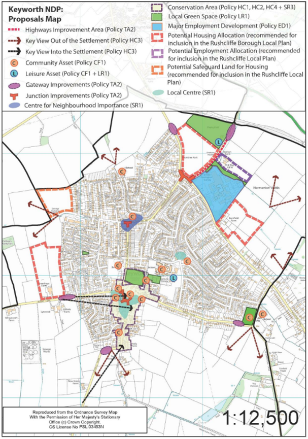
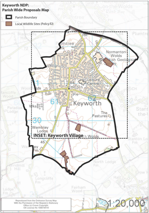
Appendix 2 - Glossary
Affordable Housing
Affordable housing is sub-divided into three distinct types of housing:
- Social Rented
- Affordable Rented; and
- Intermediate Housing
Affordable Housing: Social Rented, Affordable Rented and Intermediate housing which is provided to eligible households whose needs are not met by the market and which will remain affordable unless the subsidy is recycled for alternative affordable housing provision.
Affordable Rented Housing: Housing which meets the Housing Corporation’s Design and Quality Standards (or replacement standards) and which is let by a Registered Provider of Social Housing to a person allocated that dwelling in accordance with the Council’s Allocation Scheme at a controlled rent of no more than 80% of the local market rent.
Intermediate Housing: Discounted Sale housing and Shared Ownership housing.
Social Rented Housing: Housing which meets the Housing Corporation’s Design and Quality Standards (or replacement standards) and which is let by a Registered Provided of Social Housing to a person allocated that dwelling in accordance with the Council’s Allocation Scheme at a rent determined through the national rent regime (Rent Influencing Regime Guidance).
Allocated Site
Allocated sites are identified on a Policy [Proposals] Map within a Local Plan and illustrate the delivery of spatial policies and objectives of planning authorities.
Community Asset
A building or service which is deemed to be of importance for the community and for the use and benefit of the community.
Contextually Responsive Design/Vernacular
Design which takes account of its surrounding settings and existing development.
Development
Development is defined in planning terms under the 1990 Town and Country Planning Act. Broadly, it is considered to be ‘the carrying out of building, engineering, mining or other operation in, on, over or under land, or the making of any material change in the use of any building or other land’. Most, but not all, forms of development require planning permission.
Infill Development
Use of land located within a built-up area that is currently not developed, for further construction, especially as part of a community redevelopment or growth management program.
Infrastructure
The term infrastructure refers to the basic physical characteristics and organization of structures and facilities needed for the operation of a society or community.
Landscape Character Area
The distinct and recognizable pattern of elements which occur consistently in a particular type of landscape. It is commonly associated with forms of geology, landform, soils, vegetation, land use and human settlement.
Localism Act
The Localism Act (2011) was a feature introduced by central government containing a number of proposals to give local authorities new freedoms and flexibility, devolving power from local government to the community level.
Local Plan
The Local Plan expresses the vision, objectives, overall planning strategy, and policies for implementing these, for the whole borough. It is the policy against which development requiring planning consent in local authorities is determined.
Local Planning Authority (LPA)
A local planning authority is the local authority of council that is empower by law to exercise statutory town planning functions for a particular area.
Landscape Scheme
The manner in which the landscape associated with development is to be treated.
National Planning Policy Framework (NPPF)
Government for local planning authorities and decision-takers, on drawing up plans and making decisions about planning applications.
Neighbourhood Plans
A plan prepared by a parish council or neighbourhood forum for a particular neighbourhood area (made under the Localism Act 2011) which sets out specific planning policies for the parish which are the primary policies for determining planning applications within that
parish.
Public Realm
The space between buildings comprising the highways land, footpaths and verges.
Shared Surface
An urban design approach which removes the barriers between vehicle and pedestrian space by removing edges and restrictive features (such as road markings and pavements).
Street Scene
Elements which comprise the street environment, including roadways, pavements, street furniture.
Street Trees
Trees found within the street scene.
Sustainable Development
The Brundtland Report provides the accepted definition of sustainable development as ‘Development that meets the needs of the present without compromising the ability of future generations to meet their own needs’ (WCED, 1987). The principle of sustainable
development may be broadly described as encompassing social, environmental and economic issues, and also entailing concern with intra-generational and inter-generational themes.
Sustainable Urban Drainage (SUDs)
A series of processes and design features to drain away surface water in a sustainable manner.
Use Classes Orders/Use Classes
The Town and Country Planning (Use Classes) Order 1987 (as amended) puts uses of land and buildings into various categories known as ‘Use Classes’. Examples of use classes, include Shops (A1), General Industry (B2) and Dwelling House (C3).
Appendix 3 - The Development Strategy
(note: this appendix does not form part of the development plan, as defined by Section 38 of the Planning and Compulsory Purchase Act 2004).
A. The Development Strategy
A.1 The Keyworth Development Strategy has evolved over a period of three years based on the feedback from residents, community groups and environmental organisations. It aims to guide the delivery of the Keyworth Neighbourhood Plan and preparation of the Rushcliffe Local Plan Part 2. It should be noted that, unlike the rest of the Neighbourhood Plan, this appendix does not form part of the development plan, as defined by Section 38 of the Planning and Compulsory Purchase Act 2004.
A.2 The Development Strategy has been prepared to consider how the village, and parish, will grow over the Neighbourhood Plan period until 2028. It is not envisaged that all the development identified by the strategy would happen concurrently, but that it would be delivered incrementally over the next 12 years.
A.3 This includes identifying the sites and locations for development including the local shopping areas, the community assets and of course, key preferred sites for residential and employment growth. These have to be linked with environmental protection, conservation and highways interventions which will mitigate any negative impacts.
B. The Role of the Development Strategy
B.1 The Keyworth Neighbourhood Plan is unable to allocate any specific sites to fulfil the housing and employment growth proposed by the Rushcliffe Local Plan: Part 1 (Core Strategy) as this would require the release of greenfield land around the settlement, all of which is currently designated as Green Belt. Only Rushcliffe Borough Council’s Local Plan can remove land from the Green Belt designation. This process is scheduled to be undertaken as part of the emerging Local Plan: Part 2 (Allocations) document.
Therefore the Neighbourhood Plan’s recommended Development Strategy, which seeks the release of Green Belt sites, is now located within this Appendix of the Neighbourhood Plan and does not form part of the development plan.
B.2 It is vitally important that the Neighbourhood Plan is based around an integrated land-use strategy so that the policies satisfactorily contribute to the overall objectives of achieving sustainable development and meet the Local Plan growth targets. The Development Strategy offers this integrated approach and seeks to link the appropriate release of land in conjunction with targeted mitigation and interventions focused on delivering quality of life improvement for new and existing residents.
B.3 The Development Strategy will act as an advocate for the right type of development, in the right place, reflecting the community’s views and aspirations. It is not itself Neighbourhood Plan policy but will be used as the basis for the Local Plan: Part 2 – Allocations and has been used to shape the policies contained within the Keyworth Neighbourhood Plan.
B.4 In that regard, it is perhaps the most important component of the Neighbourhood Plan, acting as a strong material consideration in determining planning applications that come forward.
C. Developing a robust Housing Delivery Strategy
C.1 The Development Strategy is a preferred option which has been prepared in support of the Plan. The paragraphs below provide a short summary of the process with regard to the delivery of housing.
C.2 This process examined five different options for the Development Strategy all of which followed a specific overarching approach. It was not considered an option to take a ‘do nothing’ approach as the Local Plan: Part 1 requires greenfield development to meet the housing strategy it proposed (minimum of 450 new dwellings). The strategy also includes consideration of employment growth as it was clear from community consultation that jobs should be provided alongside homes.
C.3 In order to secure the delivery of the housing target, as set out in the Local Plan Part 1, the Neighbourhood Plan recommends that the Local Plan Part 2 allocates 450 to 480 new dwellings within the period of the plan, i.e. by 2028.
C.4 To support this, an independent review of the green belt has been undertaken. This noted that development to the north and south was likely to have an increased impact on the purposes of the designation of the green belt, and as such, this ensured the development proposed focused on land to the east and west of the settlement of Keyworth. This process is now being taken further by the Local
Planning Authority as part of their own Local Plan: Part 2. As part of this process Rushcliffe Borough Council has also performed their own Green Belt Review and consulted on it which has also been taken into account.
C.5 Each of the options for the Development Strategy (and the sites involved) were subject to independent testing by highways, town planning and landscape experts not affiliated with local developers or the Local Planning Authority. In addition to this, these options were presented to members of the community who provided feedback at the 2014 Keyworth Show. It was clear from this that a ‘balanced approach, which sought to ensure that new homes and employment were equally located to the east and west would be most effective at delivering the community’s aspirations.
C.6 The preferred option, presented here, and used as the basis for the Plan and the proposals map, is a mixture of two of the options. This option accommodates less employment growth than originally planned as at consultation the community sought a smaller proportion of new employment land. Given that there are three different housing sites and a single safeguarded site, the spatial strategy is considered to be deliverable, i.e. it does not rely on one single developer or landowner.
C.7 The recommended development sites are spread around the periphery of the village of Keyworth. The Development Strategy utilises four sites from within the Local Planning Authority’s Strategic Housing Land Availability Assessment. The discounted sites were not supported by the community as they were considered to impact negatively on traffic, the landscape and historic environment. In addition to this they received higher scores in some of the Green Belt assessments, i.e. they were considered more valuable sites in terms of contribution to the Green Belt.
D. The Components of the Development Strategy
D.1 As noted, the Development Strategy was first prepared and presented as part of the consultation draft of the Keyworth Neighbourhood Plan and was the subject of consultation between December 2014 and January 2015. It has since been modified based on feedback from the consultation and benefitted from further consultation with the County Council (highways and landscape), the Borough Council (local Policy and development Management) and the key developers and land owners involved.
D.2 The Development Strategy seeks to co-locate different uses into groups so that residential and employment uses (both new and existing) can support each other, new and improved infrastructure can be targeted and existing sports and recreational facilitates can benefit all users – including visitors, workers and the community. The Development Strategy has been designed to ensure that all new and existing residents are within 15 minutes’ walk of convenience retailing and 5 – 10 minutes’ walk of the ‘Keyworth Connection’ bus route. This approach is in line with guidance within national and local planning policy.
D.3 There are three elements to the strategy which are detailed in subsequent sections of this document and are shown on the accompanying Development Strategy diagram:
- Housing Allocations (including new playing fields and open space)
- Employment Allocations and Sites
- Retail and Shopping Designations
E. Proposed Housing Allocations
E.1 The Development Strategy proposes three principle allocations for new housing. These allocations are in addition to any smaller sites that may come forward from windfall applications within the settlement boundary or on brownfield sites elsewhere in the parish. Collectively these three sites are proposed to deliver at least the 450 homes identified by the Rushcliffe Local Plan: Part 1 (Core Strategy). The approximate number of new dwellings identified in the Neighbourhood Plan is around 450 to 480 homes, split between locations east and west of the settlement.
E.2 Details of these particular recommended allocations are included below and are based on the submissions made by the site owners and their agents in response to the draft Plan proposals. The number of properties has been worked out based on the site area and average density of between 20 - 30 dwellings per hectare which is considered appropriate at the settlement edge. This density excludes
any parkland that is proposed to help the development meet the requirement of Local Plan and Neighbourhood Plan policy and to integrate the development with the surrounding landscape.
E.3 Land north of Bunny Lane, Keyworth (9.8 hectares) – 150 - 160 homes. This is the single largest allocation recommended by the Development Strategy but has the benefit of more than one access point, although both will not be suitable for vehicles. It is in close proximity to the Local Centre at The Square. The development site is large enough to offer affordable housing as well as a mix of housing types, including family homes and starter homes as well as those for the elderly as specified in policy H2.
E.4 The size of the site also allows for appropriate landscape planting adjacent to existing properties and the retention of the hedgerows and mature trees on the site. Initial consultation responses from the landowner / developer demonstrate that this approach is both achievable and deliverable.
E.5 A series of design and development principles for this site is included below, to demonstrate the acceptability of the proposed allocation, and should be used to assess the acceptability of any development coming forward:
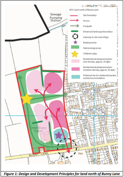
E.6 Land off Nicker Hill, Keyworth (7.6 hectares) – 150 - 160 homes. This is a small portion of a much larger site which was put forward for consideration. Developing the whole site would likely cause traffic and landscape issues that could not be satisfactorily mitigated. This recommended allocation is only accessible from Nicker Hill, but is well connected to the wider public footpath network and is close to a number of local bus routes with the opportunity to provide a route running past the site. As noted it is well related to the existing and proposed employment sites at the British Geological Survey (BGS). This means that it is bounded on two sides by existing development. The development is large enough to offer affordable housing as well as a mix of house types including family homes as specified in policy H2.
E.7 This site is located close to a Local Wildlife Site. Design should therefore seek to minimise the possibility of disturbance to that site.
E.8 A series of design and development principles for this site is included below and should be used to assess the acceptability of the proposed allocation and any other development coming forward.
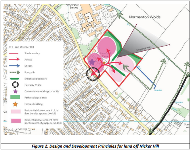
E.9 Land between Station Road and Platt Lane (8.9 Hectares) – Approx. 150 to 160 homes. The recommended development is large enough to offer a variety of housing types including affordable housing, family homes and those for the elderly as specified in policy H2.
E.10 This site can be accessed from both Platt Lane and Station Road. As the link between the two could be used as a “rat run”, mitigation should be sought.
E.11 The open space that forms part of this site shall include the trees and hedges along both Station Road and Platt Lane to a depth of 10 meters in order to maintain the attractive entrances to the village. It is also anticipated that an attractive “Village Green2 aspect can be created behind the junction of Station Road, Nicker Hill and Normanton Lane.
E.12 There is a public footpath across the site which will need to be sensitively rerouted.
E.13 The site adjoins the Platt Lane Playing Fields, a leisure hub of significance beyond Keyworth.
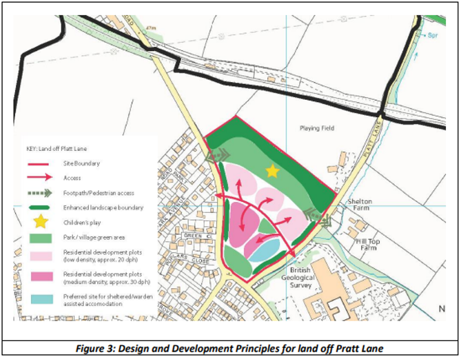
E.14 A series of design and development principles for this site is included below and should be used to assess the acceptability of the proposed allocation and any further development coming forward.
E.15 Land to the north of Debdale Lane, Keyworth (5.24 hectares) – This site has been identified as recommended safeguarded land by the development strategy. It may contribute to the growth of the village and Parish beyond this plan period to 2028. It could be suitable for approx.100 homes plus open space. This site can be accessed from Debdale Lane and the open space sited to higher ground at the north and western edges to link with the parkland delivered, associated with the land west of Keyworth.
F. The Proposed Employment Allocations
F.1 Only one small employment allocation is proposed by the spatial strategy. The majority of local employment is focused around the retail centres and the larger BGS complex (the major employment site identified in the Neighbourhood Plan) to the north-east of the village of Keyworth. The north-east corner of the village also has best access to the strategic highways network for larger vehicles, avoiding the centre of the village, which means that it is sensible to locate new employment development in this area.
F.2 Land at Shelton Farm / Hill Top Farm, Platt Lane, Keyworth (2.66 hectares) – This is largely a previously developed site occupying much of the existing farm complex and a portion of despoil land to the rear of the farm complex. It is separated from the BGS complex by a small stream and woodland area which is protected by other Neighbourhood Plan policies. It also links well with two of the principal residential development sites at Nicker Hill and Platt Lane, easily accessed by walking and cycling
F.3 It is anticipated that this site can be developed in line with the complementary uses proposed for the major employment site. In that regard B1a and B1b uses will be supported (office and research and development) alongside other ancillary uses. It is hoped that along with the BGS this can form a wider science park or technology hub offering a range of employment opportunities for residents, many who are employed in the health, science and engineering sectors (Census 2011).
F.4 Buildings should be of a similar scale and mass to those at the BGS and would have to reflect the carefully landscaped nature of that site (which includes an arboretum, geological garden and areas of grass and planting) to respond positively to the policies of the Neighbourhood Plan. Access to the site would most likely be shared with the residential development on Platt Lane.
G. Retail and Shopping Designations
G.1 Three areas have been identified within the Development Strategy as being the focus for retail. Each is considered in turn below, but is designed to ensure that new and existing residents and businesses can benefit from being within 10 – 15 minutes’ walk of a local shop and facilities. The larger allocation may benefit from a local shopping facility but for most, access to and the enhancement of, these retail centres is an important part of creating a sustainable settlement.
G.2 Local Centre at The Square, Keyworth – The traditional centre of the village includes the Parish Church and a variety of convenience retailing and some specialist stores arranged around The Square and along Main Street. The area also includes a number of community facilities including the health centre and a number of public houses. This area should be the focus of public realm improvements for the benefit of new and existing residents, as all will be using some of the services and facilities in this location.
G.3 Local Centre at Wolds Drive, Keyworth – This is a slightly smaller local shopping area comprising a small parade of shops on Wold Drive opposite a medium sized food store (currently occupied by the Co-Operative) and a public house. This area is in close proximity to the library, leisure centre (identified as a leisure hub) and secondary school and again is an important location offering retail and services to the local population.
G.4 Centre of Neighbourhood Importance at Nottingham Road, Keyworth – This is a much smaller retail area arranged around the junction of Nottingham Road and Debdale Lane. This offers convenience retailing, a public house and some speciality shopping services to the north-west of the village. Without this area much of the northern area of the town would be devoid of shopping facilities. Whilst of neighbourhood importance, the low number of services and facilities means that it is not considered to be a local centre.