Gotham Neighbourhood Plan
Gotham Neighbourhood Plan 2017 - 2028 - Adopted
Contents
- Introduction
- The Scope and Context of the Gotham Neighbourhood Plan
- Policy Context
- Objectives
- Green Network Strategy
- Housing
- Employment
- Transport
- The Village Centre
- Flooding
- Finance
Housing Appendices
- Appendix 1 – Priority Housing Sites
- Appendix 2 – Draft Design Brief GOT01
- Appendix 3 – Draft Design Brief GOT10
Background Papers (separate documents)
- One Summary of the responses to the village consultation on the first draft of the Neighbourhood Plan held in October 2017
- Two Submission on behalf of Gotham Parish Council on the 'Further Options' Document for the Rushcliffe Local Plan Part 2
- Three Summary of the responses of Gotham residents to the Rushcliffe BC Part 2 Local Plan 'Further Options' consultation (as published by RBC).
- Four Submission on behalf of Gotham Parish Council on the 'Preferred Options' Document for the Rushcliffe Local Plan Part 2
- Five Latest Housing Needs Survey
- Six Gotham Population and Housing Statistics
- Seven Housing Site Assessments
- Eight Traffic Survey Data
- Nine Locally Designated Green Spaces and the Green Infrastructure Network
1. Introduction
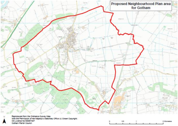
1.1 This Gotham Neighbourhood Plan has been commissioned by Gotham Parish Council (GPC) and covers the area administered by GPC, shown outlined in red in the map below. The Neighbourhood Plan forms part of the development plan for Rushcliffe in so far as it relates to Gotham Parish, being in general conformity with the RBC Local Plan Part1 Core Strategy. The Core Strategy proposes that Gotham should no longer be 'washed over' by the Green Belt but should be an 'inset' village where housing should be for local needs only.
1.2 Rushcliffe Borough Council is now preparing Part 2 of the Local Plan. The Part 2 Local Plan will fix the boundary of the Green Belt around Gotham in order that a level of development can be sustained over the period covered by the Plan. The Parish Council has made and will continue to make submissions on the contents of that Plan so as to increase the protection and conservation of the environment in the village as well as to allow sustainable development. That Plan will also need to take account of the proposals and policies in this Neighbourhood Plan.
1.3 The Neighbourhood Plan does not repeat in full policies that are already in the adopted Core Strategy or are proposed to be included in the Part 2 Local Plan, for example development within the Green Belt, the protection of open space, design and amenity etc. The Parish Council will also monitor the effectiveness of policies in the Rushcliffe Local Plan. It may periodically review its Neighbourhood Plan where policies in the local Plan have not been effective having regard to local circumstances.
1.4 The Neighbourhood Plan will form part of the context for planning decisions. The National Planning Policy Framework (NPPF) says:
“They (local planning authorities) should also, where they think this would be beneficial, encourage any applicants who are not already required to do so by law to engage with the local community before submitting their applications.”
1.5 The Plan is based on a number of background documents and these are available on the village website www.gothamvillage.org.uk under ‘Neighbourhood Plan.’. The Plan builds on and further develops the studies carried out by a number of working parties made up of members of the Parish Council and members of the public. The results of these studies are incorporated in the background papers.
1.6 This Neighbourhood Plan balances the need for housing for our local people with the rural and historic character of the village. It recognises the demand for a mix of housing that match the needs for younger and older people in particular. It does so within the legal and planning constraints and follows full and appropriate consultation.
1.7 The Plan follows from similar studies produced by the Parish Council in past years. In 2004, the Council produced a Parish Plan and a Village Design Statement (VDS), both of these made statements of principle about the village and the aspirations of the residents. The VDS was reviewed and amended in 2010. In 2015, a Community Benefit Society was set up to make a bid for the former Royal British
Legion site on Nottingham Road. While this bid did not go forward, various public meetings were held which established and reinforced the aspirations and way of life that the villagers had for their community.
1.8 These earlier initiatives enabled the Neighbourhood Plan Advisory Committee of the Parish Council to make a quick and strong start in developing the plan. In addition, planning consultant Ken Mafham Associates has been working for the village since 2008, knows the village well and has continued to support the GPC through the development of the plan.
1.9 The previous documents were produced by keen villagers and their content reflects the passion and enthusiasm of a thriving community for its environment, tradition and future prosperity. This Neighbourhood Plan is a formal planning document and therefore necessarily some of this personal input is missing. To make this document relevant to our parishioners we feel that there is still a place for some views in this introduction.
1.10 Key statements from previous studies:
Village Design Statement (2010)
The key findings from this statement are these expressed values of the residents:
- The importance the residents give to the rural roots of the village and the traditions that have built up with it.
- The status of the village, as defined by RBC, as a ‘green wash’ village situated within the Green Belt.
- The setting of the village within the hills and its position on the edge of the alluvial plain.
- The strength of this community and the preservation of this spirit within its architecture and infrastructure.
- The preservation of valuable open spaces both within and around the perimeter of the village.
Parish Plan (2005)
This showed the following key statements, values and action points:
- People like living in Gotham. Many of the population have lived in the village a long time and family units are strong.
- Review housing needs (particularly the proven need of the existing population) and liaise with appropriate outside agencies.
- Improved planning guidance (Village Design Statement).
- The visual aspect of the village buildings and open spaces.
- The preservation of Gotham as a free-standing village surrounded by green fields.
1.11 Particular statements were made in previous studies in support of the views around the village of the hills and the rural aspect as you enter Gotham from any direction. The ridge and furrow field by the old school, identified later as GOT02, is particularly valued in this way. The bridleways and footpaths provide a much valued access to the hills and surrounding countryside for walkers and horse riders alike.
1.12 This plan sets out with great care and detail a Green infrastructure Network Policy as a set of Designated Local Green Spaces which include designated areas, e.g. the Gotham Nature Reserve (GNR) and SSSI, the allotments, the Recreation Ground, the churchyard and cemetery, the local Rights of Way as well as the wildlife corridor covered by the Biodiversity Opportunity Map Focal Area for Gotham Hills
and West Leake Hills as produced by Nottinghamshire County Council. This reflects the strong feeling that Gotham residents feel for their rural setting and the local wild life.
1.13 Historically there were only 12 different surnames at the local primary school. There are many more now, but significantly those 12 still remain. This is evidence that Gotham is a strong community based on the generations of families who have lived here. They are proud of their village and its rural setting and wish to see that preserved.
2. The Scope and Context of the Gotham Neighbourhood Plan
2.1 This Plan is to do with the physical development of Gotham in the period 2017 to 2028. There are important issues to do with the future of Gotham such as education, health, social service provision and the creation of jobs. These will only be dealt with in this Plan so far as they generate land requirements or where the capacity of services may act as a constraint on future growth of housing. The main focus of the Plan is on the following topic areas.
- A Green Space Strategy
- Housing allocations
- Affordable housing
- Development Briefs for committed sites and proposed housing and employment sites
- Employment including existing and future employment sites
- A plan for the regeneration of Gotham’s historic core including the Royal British Legion Site
- Flooding and sewerage
- Dealing with any adverse effects from the development of housing at Clifton South.
2.2 The Plan includes recommended allocations which are supported by the local community. These recommended sites are set out in Appendix One. It should be noted that, unlike the rest of the Neighbourhood Plan, Appendix One does not form part of the development plan, as defined by Section 38 of the Planning and Compulsory Purchase Act 2004. These sites are identified on Maps 1 and 4 and in Chapter 6. It will be for either the Parish Council or Borough Council and the review of either the Neighbourhood Plan or Local Plan to determine which, if any, of the recommended sites at Appendix One are ultimately allocated for development.
2.3 The Context for the Neighbourhood Plan
The Parish Council and the residents see Gotham as a pleasant place to live and work. The village is certainly not without planning issues and these include environmental conditions in the village centre, along Leake Road, the empty Royal British Legion Building and a shortage of suitable housing for some groups such as the elderly or young people looking to set up home for the first time. Nevertheless, the environment in most of the village is of a good quality and the setting of the village within an area of landscape which is unspoilt at the present time is a valuable feature, even though the housing proposals at Clifton South bring the city ever closer. These
perspectives were confirmed during the recent consultation on the first draft of the Neighbourhood Plan (see Background Paper One for a full summary). To quote some respondents:
(Gotham) 'Needs to remain a village'
'I am fairly new to the village .. but I do like living here and I do not want a lot of change'
'It is essential that we have our own Neighbourhood Plan'
The village has great assets including the Memorial Hall (which houses the doctors’ surgery and library) and the associated playing fields and sports facilities. There is a thriving primary school and church, a good bus service to Nottingham and Loughborough via East Leake and a 'by pass' Gypsum Way which keeps HGVs out of the village centre. Also, the village is at the centre of a network of bridleways and
footpaths, including the recently opened Logan Trail along the site of the former railway.
Services include the doctor's surgery, the garage, a shop and post office, a fish and chip shop, 3 thriving pubs, a nursery and 2 hairdressing salons. The map below shows the parish boundary as documented by RBC in the proposal to develop the Neighbourhood Plan.
2.4 We deal with new housing sites in detail further on in the text but part of the context is the large housing allocation at Clifton South close to the village. The site was granted outline planning permission in January 2018. That site will accommodate up to 3000 dwellings and 20 hectares (50 acres) of employment land and this will inevitably affect traffic, the environment and service capacity in Gotham.
3. Policy Context
3.1 The policy context is important for the opportunities and limitations of the Neighbourhood Plan. The spatial strategy of the adopted Rushcliffe Core Strategy says:
- The sustainable development of Rushcliffe will be achieved through a strategy that supports a policy of urban concentration with regeneration for the whole of Greater Nottingham to 2028. The settlement hierarchy for Rushcliffe to accommodate this sustainable development is defined on the Key Diagram and consists of:
- the main built up area of Nottingham; and
- Key Settlements identified for growth of Bingham, Cotgrave, East Leake, Keyworth, Radcliffe on Trent and Ruddington.
In other settlements (not shown on the Key Diagram), with the exception of Newton and the redevelopment of the former RAF Newton, development will be for local needs only.
In other settlements (not shown on the Key Diagram), with the exception of Newton and the redevelopment of the former RAF Newton, development will be for local needs only.
3.2 The starting point for considering the numbers of new houses in the village is the policy that housing in Gotham should be for local needs only. Rushcliffe Borough Council has produced a number of option reports that appear to countenance numbers of new houses in Gotham that are clearly in excess of local needs. Attached as Background Paper Two are the representations made by the Parish Council to RBC on this matter. A summary of the representations made by the parishioners to the RBC 'Further Options' document can be found in Background Paper Three.
3.3 Gotham has a very limited number of sites that are Brownfield (previously used land). All of the surrounding countryside is protected by the Green Belt. An important issue is the balance to be struck between the need to provide houses and the need to
conserve the Green Belt. The latest Government policy on the Green Belt is set out in a White Paper on Housing published earlier this year. That document said on page 20 that the planning system should:
make more land available for homes in the right places, by maximising the contribution from brownfield and surplus public land, regenerating estates, releasing more small and medium sized sites, allowing rural communities to grow and making it easier to build new settlements;
maintain existing strong protections for the Green Belt, and clarify that Green Belt boundaries should be amended only in exceptional circumstances when local authorities can demonstrate that they have fully examined all other reasonable options for meeting their identified housing requirements;
The context, therefore, is that Green Belt land should only be given up for housing where exceptional circumstances exist. Provision for local need is recognised by the Parish Council as meeting that test. Making a contribution to wider needs in the Borough or greater Nottingham does not meet that test.
4. Objectives
To identify a Green Network made up of the most valuable footpaths and bridle ways, areas of biodiversity particularly the Gotham Hill Pasture SSSI, the Hill Road grassland area, wildlife corridors and open spaces and areas of green belt that serve an important planning function that warrant protection over and above Green Belt designation.
To develop policies to protect, conserve and enhance the green network identified including the proper maintenance of existing footpaths and bridleways and where appropriate locally designated green spaces.
To identify opportunities for new housing compatible with the green strategy set out above and to set out the context for affordable housing provision.
To identify new areas for employment compatible with the green strategy set out above with an emphasis on employment for local residents.
To set out design policies and prepare development briefs for new housing and employment sites.
To improve the sustainability the village historic core through traffic management, traffic calming and environmental improvements and limit environmental damage from through traffic and ensure a safe pattern of movement within the village through land use policy, traffic regulation orders and physical improvements to the road network.
To create a sustainable transport network by improving, enhancing and developing footpath, cycle and bus routes to shopping, jobs, schools in the village and elsewhere and the wider transport network including a cycle link across Clifton Pastures as part of the National Cycle Network.
To mitigate the effects of flooding and sewerage overflows on the village.
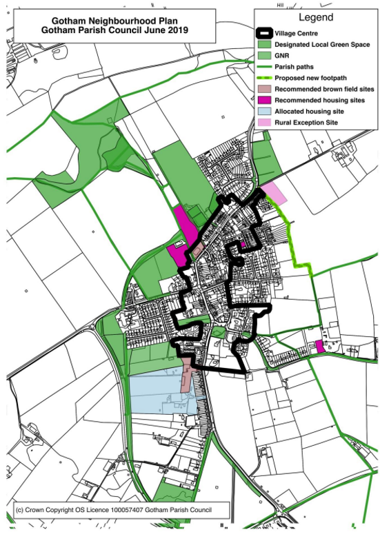
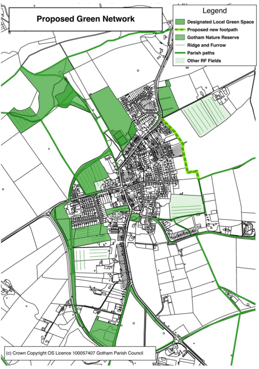
The objectives are met through the policies in the following sections. The impact of key policies on the Green Network, Housing and the Village Centre can be seen in the Gotham Neighbourhood Plan Map below which shows an integrated view.
5. A Green Infrastructure Network Strategy
5.1 The Gotham Neighbourhood Plan proposes a Green Infrastructure Network. This is a key proposal to conserve and enhance what is best in the village and to encourage sustainable forms of transport within the village. The components of the Green Infrastructure Network; made up of designated local green spaces and the links between them are dealt with below.
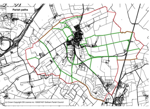
Footpaths and bridleways
5.2 There are significant health benefits from the use of Rights of Way (RoW) and footpaths for walking, cycling and horse riding. These need to be safe, attractive and convenient. The Rushcliffe Residential Design guidelines show how this can be achieved. They are the strands in the green network that are of special value where they;
- lead from the village into the countryside through sites of importance for bio diversity some of which are or may be threatened,
- are used to connect components of recreation provision such as playing fields and allotments and the residential areas they serve,
- function as pathways as a way of sustainable travel within the village particularly to schools, shops, community centres, employment centres and areas used for active recreation, such as allotments and playing fields.
Areas of Biodiversity
5.3 The National Planning Policy Framework says:
The planning system should contribute to and enhance the natural and local environment by:
- protecting and enhancing valued landscapes, geological conservation interests and soils;
- recognising the wider benefits of ecosystem services;
- minimising impacts on biodiversity and providing net gains in biodiversity
- where possible, contributing to the Government’s commitment to halt the overall decline in biodiversity, including by establishing coherent ecological networks that are more resilient to current and future pressures;
5.4 The Rushcliffe Local Plan Pt.1 Core Strategy under Policy 17 states:
- The biodiversity of Rushcliffe will be increased over the Core Strategy period
by:- protecting, restoring, expanding and enhancing existing areas of biodiversity interest, including areas and networks of priority habitats and species listed in the UK and Nottinghamshire Local Biodiversity Action Plans;
- ensuring that fragmentation of the Green Infrastructure network is avoided wherever possible and improvements to the network benefit biodiversity, including at a landscape scale, through the incorporation of existing habitats and the creation of new habitats;
- seeking to ensure new development provides new biodiversity features, and improves existing biodiversity features wherever appropriate; supporting the need for the appropriate management and maintenance of existing and created habitats through the use of planning conditions, planning obligations and management agreements; and
- ensuring that where harm to biodiversity is unavoidable, and it has been demonstrated that no alternative sites or scheme designs are suitable, development should as a minimum firstly mitigate and if not possible compensate at a level equivalent to the biodiversity value of the habitat lost.
and
- Development on or affecting other, non-designated sites or wildlife corridors with biodiversity value will only be permitted where it can be demonstrated that there is an overriding need for the development and that adequate mitigation measures are put in place.
5.5 Gotham parish contains part of one of the biodiversity Focal Areas (Gotham Hills, West Leake to Bunny ridgeline) identified within the ‘Rushcliffe Biodiversity Opportunity Mapping Report’ – C Jackson and N Crouch 2015 – published by Nottinghamshire Biodiversity Action Group. The Parish therefore, is an important component of the overall Rushcliffe biodiversity network. The report states that the
Gotham Hills and West Leake to Bunny ridgeline is an existing network of woodland and grassland that can be enhanced and buffered, and concludes that there is great potential for creating important links between existing habitats. Also, opportunities exist to protect and enhance this network, including providing new linkages between sites and ensuring the appropriate management of existing sites and green spaces.
5.6 Policy GS1 below promotes a green infrastructure network to support local wildlife and its habitat both inside and beyond the parish, especially to support the Rushcliffe Nature Conservation Strategy and the priority habitats and species. The network consists of corridors (the former railway, field margins, hedgerows, footpaths, streams and dykes, and wetland and pond habitats), and green spaces (pastures, parklands, native woodlands and species rich grasslands) and highlights the need to preserve and enhance these.
5.7 Where development is acceptable the aim will be to achieve a form of development that can assist the protection of wildlife by incorporating habitat enhancing features such as bird or bat boxes or appropriate native woodlands, planted tree and hedgerow
boundaries, ponds, wetlands and meadows or other enhancing features.
Green Belt
5.8 The five aims are
- to check the unrestricted sprawl of large built-up areas;
- to prevent neighbouring towns merging into one another;
- to assist in safeguarding the countryside from encroachment;
- to preserve the setting and special character of historic towns; and
- to assist in urban regeneration, by encouraging the recycling of derelict and other urban land.
5.9 The Further Options document published by Rushcliffe BC in February 2017 mapped a number of suggestions from landowners and developers as to sites in the Green Belt that could be developed for housing. We have looked at those areas of the Green Belt and a number of others and identified for inclusion in the Green Network areas that meet one or more of the five aims to a very significant extent. Rushcliffe has published a revised assessment of the value of the sites in terms of their importance to the Green Belt. While locals and the Parish Council would assess these sites as being more important, the revised assessment is closer to the situation on the
ground than the earlier assessments.
Designated local green space
5.10 Designated local green spaces are a policy recently introduced by Government with the purpose of allowing the community to identify areas of open space that need an extra layer of protection. The NPPF says they are appropriate:
- where the green space is in reasonably close proximity to the community it serves;
- where the green area is demonstrably special to a local community and holds a particular local significance, for example because of its beauty, historic significance, recreational value (including as a playing field), tranquillity or richness of its wildlife; and where the green area concerned is local in character and is not an extensive tract of land.
- Local policy for managing development within a Local Green Space should be consistent with policy for Green Belts.
5.11 Para 10 of the National Planning Practice Guidance makes it clear that land can be covered by both green belt and local green space designations. Members of the Parish Council have undertaken a systematic assessment to identify green areas of special value. Background Paper 9 documents the detail of each of the designations and shows the assessment against the criteria in the NPPF (paragraph 77). Landowners were contacted during the Section 15(2) consultation and comments have been incorporated in the background paper.
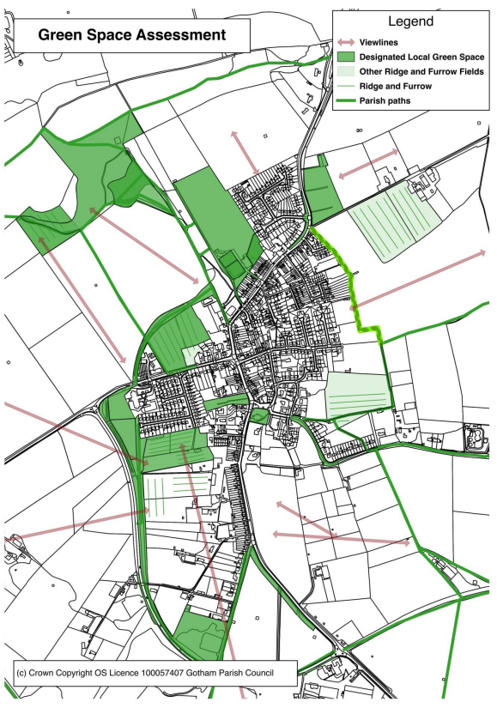
5.12 The results of the analysis work are shown on Map 2b Green Space Assessment. Key features are views into and out of the village and landscapes that have intrinsic historic value particularly surviving mediaeval ridge and furrow. There are also several footpaths and bridleways not only valuable for sustainable journeys but also of significant biodiversity value. The biodiversity of others could be improved with the right sort of management regime.
5.13 The village consultation on the first draft of the Neighbourhood Plan was overwhelmingly in favour of the proposed Green Infrastructure Network policy.
5.14 Taking all these criteria into account the Parish Council are proposing a Green Infrastructure Network as shown on Map 3. Within the Network the following policies will apply:
Policy GS1 Protective and Enhancement Measures for a Green Network
Footpaths and Bridleways
Within the Green Network shown on Map 3, footpaths and bridleways will be given a high priority for maintenance and enhancement. The bio diversity of hedges and woodlands adjacent to sustainable route-ways will be conserved. Planning applications which will result in closure and diversion of a public right of way will not be permitted unless it can be demonstrated that satisfactory alternative provision can be made.
Areas of biodiversity value
Developments which harm designated wildlife sites and ancient woodlands in the Plan area will not be supported. Other developments which include provision for, or contribute to, the establishment and retention of a network of green infrastructure within the parish will be looked on favourably. Proposals which contribute towards new links and/or enhancement of the existing green infrastructure network will be supported. Proposals should consider opportunities to retain, enhance and incorporate features which are beneficial for wildlife and habitat creation through their landscape proposals and design.
Locally designated green-spaces
Within designated local green-spaces the protective policies set out in Green Belt policies will be applied and very special circumstances would need to be demonstrated for inappropriate uses to be allowed.
Recreation uses
Where development is proposed for recreation or other uses acceptable within the Green Belt; planning permission will be granted for well designed proposals that are sympathetic to the character of the village.
6. Housing
6.1 As we have said in the section on context, the Core Strategy states that housing in Gotham should be for local needs only. The Core Strategy does not define local needs. It suggests the scale of development will be small:
3.3.17 in other settlements, development will meet local needs only. Local needs will be delivered through small scale infill development or on exception sites (see Policy 8). Beyond this, where small scale allocations are appropriate to provide further for local needs, these will be included in the Local Plan Part 2: Land and Planning Policies Development Plan Document, including
Neighbourhood Plans.
Based on this context material our conclusions are
-
- Neighbourhood Plans have a key role
- The first port of call will be infill sites
- Any allocations will be small scale
- Densities appropriate to a rural village and in line the Residential Design Guide published by Rushcliffe BC.
6.2 We have looked at the practice in a number of other areas and it is clear that, whilst local needs are broader in scope than affordable housing on rural exception sites (because it includes market housing and takes a longer term view), nevertheless
the two concepts are alike in that the starting point is the need for housing of residents in Gotham, both now and over the Plan period.
6.3 After a period during which housing need was given priority over Green Belt and other protective policies the Government has signalled in the Housing White Paper a change of direction. On page 20 that document said the planning system should:
make more land available for homes in the right places, by maximising the contribution from brownfield and surplus public land, regenerating estates, releasing more small and medium sized sites, allowing rural communities to grow and making it easier to build new settlements;
maintain existing strong protections for the Green Belt, and clarify that Green Belt boundaries should be amended only in exceptional circumstances when local authorities can demonstrate that they have fully examined all other reasonable options for meeting their identified housing requirements;
6.4 Against this background and bearing in mind the adopted Core Strategy for Rushcliffe this Neighbourhood Plan, in looking at housing allocations, takes as its starting point the Green Network set out in policy GS1.
6.5 In accordance with planning legislation, the Plan recommends housing sites which may be allocated within future reviews of the Neighbourhood Plan or Local Plan. These do not form part of the development plan as defined by Section 38 of the Planning and Compulsory Purchase Act 2004, but are identified in this chapter and in Appendix One.
6.6 Affordable housing
This is not the same as housing for local needs. Local needs have to do with the source of demand whereas 'affordable housing' is to do with ability to meet market house costs. The definition of affordable housing is social rented, affordable rented and intermediate housing, provided to eligible households whose needs are not met by the market.
6.7 The Parish Council has for some time supported the development of an area of land behind the former Royal British Legion building for an affordable housing scheme. Four developments suggest the restriction of this site to affordable housing should now be reconsidered:
- During the Rushcliffe BC Further Options consultation a significant proportion of respondents supported the development of the site for general housing There has been no progress whatsoever in bringing the land forward for affordable housing development.
- The site was considered suitable under the “Rural Exception Regime” whereas the current exercise is part of main stream housing provision.
- The British Legion building has now remained empty for three years and there are no proposals for its use in the public domain and it may be that the part conversion and part redevelopment of the site for housing and the inclusion of a limited part of the site known as GOT 1 will prove the best option.
6.8 Self Build and Custom Build housing
Government gives a high priority to increasing numbers of custom built and self built houses. Custom build and self build is where design is in the hands of the client. Self build is where the client either purchases or leases a plot of land and carries out the building scheme or commissions the work directly. Rushcliffe BC has a legal obligation to keep a register of people with an interest in such an initiative. Local residents are registered as seeking self build plots. The fact that the housing sites in Gotham are small and are not in the hands of volume house builders suggests there is potential in Gotham for custom and self build. Policy H2 proposes that the Parish Council with other stakeholders prepares a brief for each housing site. If a more general requirement for custom/self build plots is recognised, then a requirement could be incorporated in one or more such briefs.
6.9 Housing provision by type of dwelling
The Neighbourhood Plan covers a period of around eleven years and so needs to look at local and affordable housing needs over that period. People currently living in Gotham, who wish to remain may need to change the size and type of dwelling as their circumstances change over the next eleven years. We attach as part of Background Paper Six a study of the dwelling size and the age distribution of residents of Gotham as at 2011.
6.10 The assessment of housing need is not an exact science because there are too many imponderables. In very broad terms an increase of between 10 and 15% by 2028 on the base figure of 700 households in 2011 would seem about right. The Housing Needs Survey, Background Paper Five, showed 12% of responding household with people wishing to set up their own home in the next five years. If that percent were applied to the total of 700 or so dwellings it would be around 70 households. Spread over the period 2017 to 2028, the average would be 7 dwellings per year although clearly the actual annual rate would vary. The proposals in the Neighbourhood Plan are allowing around 25% on top of this for flexibility. We are emphatically not saying Gotham can contribute sites for 100 dwellings to any shortfall of housing land that may exist in Rushcliffe at the present time. These figures are slightly higher than the amount of growth favoured in the response of Gotham residents to the Rushcliffe Further Options consultation, Background Paper Three, but the local needs context and the long phasing were not set out in the same way at that time. Background Paper Three shows the results of the village consultation which showed overwhelming support for the rate of growth proposed in this plan.
6.11 The figures in Background Paper Six show that the proportion of one bedroom accommodation in Gotham is much lower than in either Rushcliffe as a whole or in the East Midlands. In the Gotham Housing Needs survey also attached as Background Paper Five, of the 168 (21%) replies almost 60% said that more small family homes were needed. 67% said more homes were needed for elderly people. Young persons and the very elderly both tend to need or be able to afford one bed accommodation; in the latter case the amount of support provided is changing quite rapidly. In broad terms the future provision of housing should include a significant number of one bedroom accommodation.
6.12 Conversely the amount of three bed accommodation in the housing stock of Gotham is high and so we would expect only a modest proportion of the new additions to be in that size category.
6.13 The affordable housing need study that was carried out shows around 10 units are required but this is simply a snapshot in time and the need over the period to 2028 is likely to be a lot higher.
6.14 Potential housing Sites
Our starting point is that housing allocations should be decided on what is best for the village and for future residents. The Green Network proposed in Policy GS2 will be a key consideration. Other criteria are:
- Proximity to services
- Effect on the quality of life in existing housing including privacy and outlook
- Effect on the ability to function effectively of services, such as education and health
- The extent to which a development will allow the village to fit at least as well into the surrounding landscape as it does now
- Defensible Green Belt boundaries
- Vulnerability to flooding and effect on the risk of flooding in other areas of the village
- Impact on the capacity of the sewerage works
6.15 As set out in paragraph 6.5, this Neighbourhood Plan only recommends housing sites which will be allocated through the future review of either this Neighbourhood Plan or the Local Plan. Therefore, until they are allocated they do not form part of the development plan.
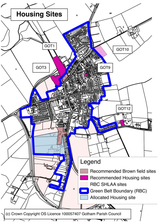
6.16 In the past, sites tended to be suggested for allocation through the Strategic Housing Land Availability Assessment (SHLAA) as entire fields or aggregations of entire fields. This is sometimes called planning by field boundaries. These are carried through into local plans and eventually developed on the ground. The boundaries thus formed then make no real sense in planning or design terms. The Neighbourhood Plan recommends a different approach. Given the context for numbers and type of housing, the Green Space Network and the structure of the village we see parts of the recommended housing sites in Appendix One having the potential for housing
(numbers refer to the Rushcliffe Further Options document). A Plan extract from the Rushcliffe BC document is included in Background Paper Seven. We see a real advantage in having a number of small sites in terms of choice and steady delivery through the plan period.
6.17 The priority is the development of brownfield sites. One site is already in the process of being put forward for development:
- The former Royal British Legion Building and site.
In addition the following sites could be brought forward as possible future sites depending on current owners’ business plans.
- The NCT Bus Depot (included in the plan)
- The Machins Industrial Estate (not included in the plan)
6.18 To supplement this resource the 'Further Option' sites have been looked at in detail to see if they are appropriate for allocation in the Rushcliffe Local Plan. The results of the exercise are set out in Background Paper Seven. There are two main greenfield sites GOT 01 an GOT 03, supplemented by known infill sites GOT 09 and GOT12. All sites are vacant, available (in the SHLAA) and can be delivered in the next 5 years. The following sites should be a priority for allocation for development in any future review of the Neighbourhood Plan or Local Plan.
- GOT 01 Land behind the Royal British Legion Building
- GOT 03 Land north of Kegworth Road/Home Farm (East)
- GOT 09 Land at Gladstone Avenue
- GOT 12 Ashcroft – Moor Lane
6.19 Rural Exception Scheme
A Rural Exception Scheme is where affordable housing is allowed on a site in rural areas that would not normally be given planning permission. One scheme has been identified as follows:
- GOT 10 Part of Glebe Land Nottingham Road.
The site will remain in the Green Belt but the Neighbourhood Plan supports an initiative for the construction of up to 15 houses for affordable housing needs of Gotham residents as revealed by the Housing Need Survey to local families as well as the elderly. As with all of the allocated housing sites a development brief will be prepared in conjunction with residents and incorporated in the Neighbourhood Plan.
6.20. Listed Buildings. There are five listed buildings in Gotham: The church (Grade 1), the Well House, the old Primary School building, the Manor House and the Tithe Barn (all Grade 2). The Tithe Barn is the only one affected in the housing sites as it is part of the NCT Bus Depot. If this site is developed its management will be part of the matters to consider.
6.21 These sites together with the brownfield resource, have a total capacity of around 85 dwellings and so there is plenty of scope at the design brief stage for limiting the building envelope on the sites so that the development is of positive benefit to the village. We see this as fully in accord with policy set out in the National Planning Policy Framework:
- Pursuing sustainable development involves seeking positive improvements in the quality of the built, natural and historic environment, as well as in people’s quality of life, including (but not limited to):
- making it easier for jobs to be created in cities, towns and villages;
- moving from a net loss of bio-diversity to achieving net gains for nature;
- replacing poor design with better design;
- improving the conditions in which people live, work, travel and take leisure; and
- widening the choice of high quality homes.
- Plans and decisions need to take local circumstances into account, so that they respond to the different opportunities for achieving sustainable development in different areas
6.22 The design brief approach to site capacity is also in accordance with local policy, in particular the statement on page 9 of the Rushcliffe Design Guide that context is a major theme and the relevant design policies in the Core Strategy. Policy 10 of the
Core Strategy is entitled Design and Enhancing Local Identity.
6.23 The village consultation on the first draft of the Neighbourhood Plan agreed overwhelmingly that the proposed number of new dwellings at about 60 to 70 over the timeframe of the plan was the right level of development and could be sustainable in keeping with the stated RBS policy to keep the newly inset villages as villages.
6.24 The consultation and subsequent consultations confirmed the prioritisation of plots as laid out in this section as well as re-confirming the need for smaller dwellings to enable older residents to downsize (one level homes), and also for starter homes.
Affordable housing was also a key aspect of the consultation responses.
H 1 Sites
The Neighbourhood Plan will recommend the allocation of land for housing made up of parts or the whole of sites as shown in Map 4. The sites listed in Appendix One are those to which priority should be given in any review of the Part Two Rushcliffe Local Plan or any review of the Neighbourhood Plan.
H2 Design Briefs
Development of the sites will be in accordance with development briefs that will be prepared. The briefs will include:
- Layout and density
- Links to the Open Space Network
- Landscaping and bio diversity
- Building materials, form and massing
- Effect on neighbouring properties
H 3 Affordable Housing
The priorities for affordable housing are the provision of bungalows and one bed room flats. In the light of the likely mismatch between demand and supply in Gotham, priority for allocation of affordable housing in Gotham should, where possible, be given to Gotham residents where this is possible, for instance within exception sites.
Design Briefs
At the time of submission design briefs have been started for the RES scheme GOT 10 and for the biodiversity mediation measures around GOT1. This is the preferred site for housing development by the villagers and although adjacent to an important link in the Green Infrastructure Network has been shown through an ecological survey to have little ecological value. (The ecological survey contains sensitive information about a protected species and can be obtained by applying to the Parish Council.)
6.25 The early drafts of these Design Briefs are included as Appendices. Along with the design briefs for the other plots, these will be further developed over the lifetime of the plan and will be subject to ongoing consultations with residents.
7. Employment
7.1 The first Neighbourhood Plan consultation (see summary in Background Paper One) indicated a need for the provision for employment for local people. This plan recognises that Gotham wishes to be a balanced community and that appropriate employment provision as part of any development would be welcomed, provided appropriate development briefs are in place. If the Machin's industrial estate were to be developed in whole or part for housing then this should only be done if there were alternative facilities especially the provision of small units for starter businesses.
7.2 St Gobain, formerly British Gypsum, has facilities on the southern edge of the village and is seeking to expand these (BG reference SG1). It also owns other land in the village which they have put forward as potential development sites (BG reference SG2 (GOT7), SG3 & SG4 (GOT1). Of these GOT1 is supported within his plan for housing. There is no objection in principle to the expansion of SG1 but Gotham is not a suitable location for large scale industrial and/or storage sites that do not have a connection to local activities already taking place and/or provides significant numbers of jobs suitable for local residents. The need for land related to plaster board
manufacture in or close to Gotham village depends on the space available at the main St Gobain site at East Leake.
Policy E 1 – Employment
A development brief will be prepared for any employment development and will be included in a future draft of the Neighbourhood Plan. It will include:
- Layout and density
- Links to the Open Space Network
- Landscaping and bio diversity
- Building materials, form and massing
The expansion and intensification of the British Gypsum site in the south of the village will be supported subject to it being demonstrated that any non B1 business activity is directly related to the operation of British Gypsum at East Leake and that there are not more sustainable sites available at East Leake.
8. Transport
8.1 Gotham has the benefit of an excellent bus service and would like to see improved links to the tram service at Clifton, the train services at East Midlands Parkway and the East Midlands Airport. We would seek dedicated cycleways to link with the communities and facilities of East Leake and Clifton and if possible incorporate them into the wider national cycle network.
8.2 We would support improvements to the public transport infrastructure and would help to negotiate contributions from any village development towards this. We would also include access to these facilities as part of any development design brief.
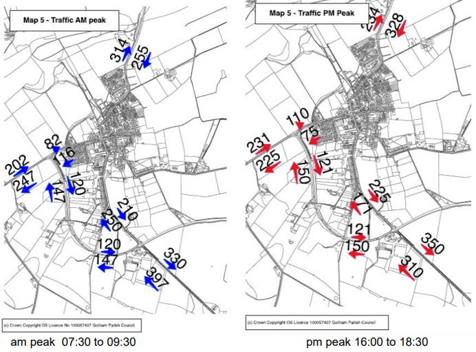
8.3 As regards car traffic, the Parish Council has collected extensive information on the pattern of movement in the village and this is attached as Background Paper Eight. The Council has also requested detail of the likely flows of traffic as a result of the development of housing at Clifton South but so far this has not been forthcoming.
8.4 The village consultation on the draft of the Neighbourhood Plan identified many issues to do with traffic as well as parking. Problems identified include: congestion and parking on Kegworth Rd/Hall Drive and around the primary school at the beginning and end of the school day, congestion and parking issues along Leake Road from the NCT depot to Hill Road, congestion along Nottingham Road including several narrow side road entrances. Further consultations also identified blind corners on Moor Lane and congestion at certain times in the centre of the village around the Square and the cemetery.
8.5 The following maps show the results of a traffic survey carried out in the summer of 2017 whilst it was still term time at the primary school. For more details refer to Background Paper Eight.
Policy T 1 – Traffic Calming, Congestion and Parking
The priority within the village is the safety and convenience of residents. Traffic speed will be restricted to defined limits by traffic calming at such sites as the entrance to the village at Nottingham Road, the Curzon St/Kegworth Rd junction, the Square and the entrance to the village from East Leake.
The amount of traffic passing through the village and the existing issues with parking will be a consideration in assessing development proposals and will take into account wider cumulative impacts.
Traffic Regulation Orders and other means may be used to deal with congestion and parking on Leake Road and Kegworth Road/Hall Drive at school arrival and departure times.
Policy T 2 – Sustainable transport
Support development proposals that provide for improvements to foot, cycle and public transport provision between the village, the wider national networks and the Greater Nottingham conurbation. In particular, a dedicated cycle route is supported from Gotham to the new development at Clifton South to enable safe access to the National Cycle Network as well as the tram terminus and cycle routes into the greater Nottingham area.
9. The Village Centre
9.1 It is not easy to define a village centre for Gotham. Community services such as
the primary school, the church, the Memorial Hall and the shop are some distance
apart. In architectural terms the 'centre' is low density and of a linear character.
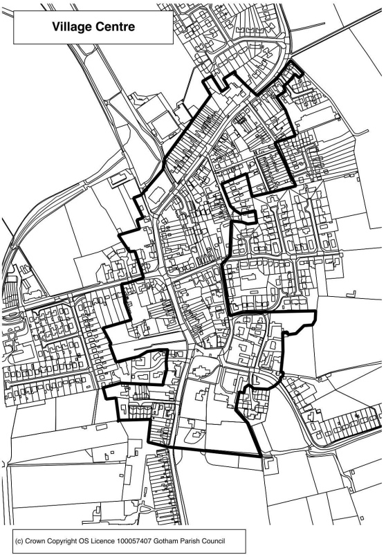
9.2 Map 6 below outlines the main historic area of the village and the policies define
the Square, the former Royal British Legion building and the area between them as
an area within which regeneration and improvement will be a high priority.
9.3 The exact planning character of the centre is difficult to define and will develop as
opportunities for development and planning applications occur.
Policy VC 1
Within the whole Village Centre Regeneration Area shown on Map 6 a high standard of design will be required including landscaping schemes that will make a positive contribution to the village.
The former Royal British Legion site has a negative effect on the street scene and has been identified as a brownfield opportunity for new housing in Policy H1. A development brief will be drawn up in accordance with Policy H3. Should
development be delayed then a suitable interim treatment of the site will be sought.
Around the Square the emphasis will be on conservation of the existing character. However, the Parish Council will seek funding for further tree planting and additions to / improvement of street furniture.
10. Flooding
10.1 Presently, parts of the village flood during heavy rainfall. Whilst this is partly due to the drainage system not functioning effectively because of blockage due to leaves and other rubbish, in other cases the problem is due to limited capacity in the system. Para 110 of the National Planning Policy Guidance requires that Local Plans should “ manage flood risk from all sources, taking account of advice from the Environment Agency and other relevant flood risk management bodies, such as lead local flood authorities and internal drainage boards “. Since the Neighbourhood Plan will form part of the development we are adopting the same approach.
10.2 There is evidence that the sewerage works serving the village is operating at capacity and that there are occasional untreated discharges. In the section on housing we refer to the need to release sites so that development, justified solely on local housing needs, proceeds at a steady pace through the Plan period. This provides an opportunity to ensure that the increased load on the sewerage works does not exceed capacity at any point in time
Policy FL 1 - Sewerage
Where required, applications for development shall be accompanied with documentation demonstrating that there will be no adverse impact on the existing sewage capacity of the village or specify the measures that will be taken to ensure
that its impacts can be adequately addressed.
11. Finance
Proposals in the Plan, such as the improvement of the village centre and the enhancement of the proposed Open Space Network, have spending implications. These can be funded by Section 106 Orders or by a Community Infrastructure Levy (CIL) on new developments. We estimate that over the Plan period this would produce a capital receipt for Gotham Parish of around £100,000 from residential development spread fairly evenly over the Plan period. It may be that this money can be used to lever additional funds from other sources. The priority will be spending on capital schemes that do not involve ongoing maintenance costs or even reduce such costs.
Any CIL from industrial or commercial development would be additional to this amount.
Appendix 1: Housing Sites to which priority should be given in any review of the LPP2 or Neighbourhood Plan
Brownfield
- The former Royal British Legion Building up to 11 dwellings (Any development must include provision to create viable access
to GOT1 and GOT3)
Possible brownfield sites depending on owners future business plans NCT Bus Depot (included in the plan) up to 19 dwellings
Greenfield
- Got 1 Land behind the Royal British Legion Building - up to 20 dwellings
- Got 3 Land north of Kegworth Road/Home Farm (east) - up to 20 dwellings
- Got 9 Land at Gladstone Av. (extant planning permission) - 3 dwellings
- Got 10 Glebe land at Nottingham Road (part thereof) - up to 12 dwellings
- Got 12 Ashcroft – Moor Lane (self build) - 1 dwelling
Appendix 2: Draft Development Brief for GOT01 (site behind the former RBL building)
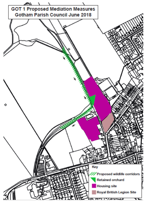
1. Context
The support in the Neighbourhood Plan for market housing on the site known as GOT01 on the Neighbourhood Plan Map is conditional on suitable mitigation measures to minimise any harmful effects on wildlife and to conserve bio diversity.
A report on the site was commissioned from Ecology Consultants and is available via the
Gotham PC web site.
The approach taken has been to achieve no net loss to biodiversity or to the function of this
part of Gotham as a wild life corridor.
2. Mitigation measures
The proposed mitigation measures are shown on Plan One. They are
- Provision of an alternative wildlife corridor along the eastern edge of agricultural land
to the West of GOT01 - Retention of the traditional orchard on GOT01
- Retention of the existing hedges along the NE and SW boundaries of the site
3. Wildlife Corridor
The alternative corridor should be sown with wildflower seed and subsequently manage to
produce a species mix similar to that currently on GOT01 which is:
abundant/locally dominant red fescue, soft brome, false oat grass and Yorkshire fog, with
vegetation height at approximately 40 cm. Broad-leaved herb species in the sward
comprised (amongst others) red clover, common vetch, dandelion, cut leaf cranesbill, dove
foot cranesbill, creeping cinquefoil, forget me not, ribwort plantain and ragwort.
4. Orchard
The Ecological report describes the traditional orchard as comprised of:
apple, wild cherry, dog rose and hawthorn. The understorey was densely vegetated with dominant bramble, abundant common nettle and occasional wood avens The management regime should, as a minimum, retain this amount of bio diversity.
5. Hedgerows
The Ecological report describes the hedge rows as being:
comprised of hawthorn, apple, common lime, elder, rose sp., wild cherry and rowan. As the hedgerow contains 7 woody species it is likely to qualify as an ‘important hedgerow’ under the Hedgerow Regulations (1997). The understorey of the hedgerows consisted of plant species including forget me not, cleavers, common nettle, white-dead nettle, garlic mustard, bluebell, periwinkle and hedgerow cranes bill.
The management regime should, as a minimum, retain this amount of bio diversity.
6. Finance and management
The items set out above will in due course need to be incorporated in a S106 agreement. It will be the responsibility of the owner/ developer to negotiate the terms under which the alternative wildlife corridor is provided on adjacent land.
If those negotiations are not successful then the corridor will have to be provided within GOT01 although we accept this would reduce the capacity.
The Parish Council would be willing to use its knowledge and contacts in an enabling role.
7. Further work
The Ecological Report identifies further work that would be needed prior to any planning permission:
The findings of this assessment establish the need for protected species surveys that are required to achieve compliance with relevant legislation. Surveys are commonly required for widespread species such as bats, great crested newt, reptiles and badger; but may be necessary for other species if suitable habitat is present.
Appendix 3. Draft Development Brief for the Rural Exception Site at Nottingham Rd. (GOT10)
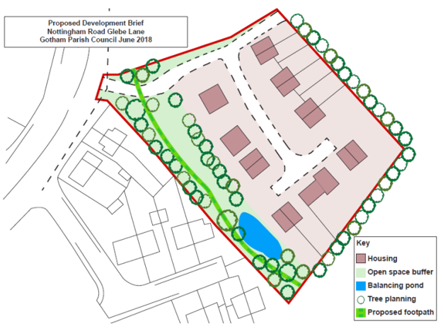
1. Context
The Neighbourhood Plan supports the proposal for housing at the Glebe Land Nottingham Road under the Rural Exception Site regime.
The opportunity at Nottingham Road emerged fairly late in the Neighbourhood Plan process and was the subject of an additional consultation exercise late in 2017. Nearby residents had a number of concerns that are set out in the Consultation Statement. This Development Brief addresses those concerns.
This Development Brief should be read in conjunction with the policies in the Neighbourhood Plan and the emerging Part Two Local Plan for Rushcliffe as well as Supplementary Planning Documents particularly the Residential Design Guide.
2. Land Use
The majority of the site is proposed for housing but a larger proportion of a larger site is now proposed as buffer strip/wild life area and balancing pond.
3. Access
The development will be served by a single access from Nottingham Road currently used for farm traffic. The access will need to be designed to the standards laid down in the guidance published by the highways Authority; Nottinghamshire County Council.
4. House Type and Layout
The draft layout and housing mix prepared by GEDA (the Contractor) has been retained but translated some distance to the NE.
5. Landscaping
A wider strip of open space will be provided between the development and existing houses to the west. The strip will accommodate and extension of the public footpath network on the east side of the village as shown on the Neighbourhood Plan Map. The area will be seeded with a mix appropriate for neutral grassland. Trees to be planted as shown in Plan One; species mix to include oak, silver birch and ash.
On the eastern and southern boundaries screen planting is to be undertaken. It is felt that a hawthorn hedge with some of the hawthorn to be allowed to grow into standards would be appropriate together with some oak standards among the hedge.
The buffer strip will need some minimal maintenance to safeguard against invasive species. It is suggested that the same body that maintains the balancing bond undertakes maintenance of the landscape strip.