Upper Broughton Neighbourhood Plan
Upper Broughton Neighbourhood Plan 2011-2028
Contents
- Introduction
- Protecting Green Areas and Views
- Traffic and Parking
- Services, Facilities and Infrastructure
- Heritage and Design
- Rural Character
- Housing
- Employment
Appendix 1: Non-planning Issues
Appendix 2: Local Green Spaces: Summary of Reasons for Designation
Appendix 3: Important Views Summary
1. Introduction
Neighbourhood Plans
1.1 The 2011 Localism Act has given communities the right to draw up a Neighbourhood Plan. This right is aimed at giving local communities genuine opportunities to influence the future of the places where they live.
1.2 The Upper Broughton Neighbourhood Plan will allow people, who live, work and have a business in the parish to have a say where they think new houses and businesses should be located and what they should look like. A Neighbourhood Plan can also identify and protect important Local Green Spaces, conserve local heritage and protect areas of nature conservation interest. The Upper Broughton
Neighbourhood Plan will be a statutory plan which means that once it has been finalised, it will be used to determine planning applications in the parish.
The Upper Broughton Neighbourhood Area
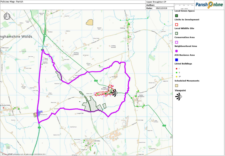
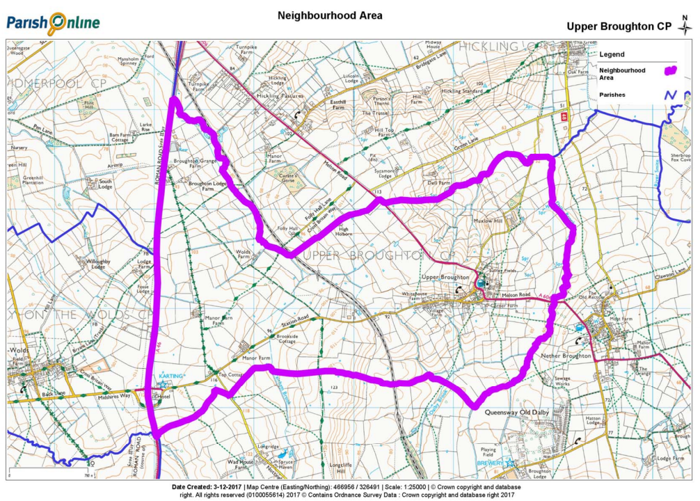
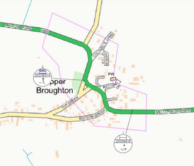
1.3 The Neighbourhood Area comprises the parish of Upper Broughton which is located within the Rushcliffe Borough Council area of Nottinghamshire. Upper Broughton is a rural parish (792.4 hectares) in the Vale of Belvoir with a population of 327 and 135
homes (2011 Census). It is located on the border with Leicestershire, approximately 9km (5.6 miles) northwest of Melton Mowbray.
1.4 The parish contains the settlement of Upper Broughton which is located on the southern slope of a broad hill facing the Belvoir escarpment. The neighbouring Leicestershire village of Nether Broughton lies around 0.8km (½ mile) to the south east. Once a farming stronghold, Upper Broughton is now mainly a commuter village, well situated for Leicester, Nottingham, Melton Mowbray, Loughborough and surrounding areas.
1.5 Upper Broughton was designated as a Neighbourhood Area on 5 November 2016. The Plan is being prepared by Upper Broughton
Council, supported by the Upper Broughton Neighbourhood Plan Steering Group. The Plan covers the period 2011 to 2028.
1.6 The Upper Broughton website provides information and updates about Neighbourhood Plan preparation and its progress.
Basic Conditions
1.7 Only a draft Neighbourhood Plan that meets each of a set of basic conditions can be put to a referendum and be adopted. This means that there is not an entirely free hand over how the Plan is prepared. In particular, a Neighbourhood Plan must have regard to the National Planning Policy Framework (NPPF) and the Development Plan for the area.
Rushcliffe Local Plan
1.8 The relevant Development Plan for the area is the Rushcliffe Local Plan. For the purposes of this Neighbourhood Plan, the relevant parts of the Local Plan 2011-2028 are:
Local Plan Part 1: Core Strategy
1.9 The Core Strategy adopted on 22 December 2014, provides the vision and spatial strategy for Rushcliffe Borough. Most new development will be directed to the main built up area of Nottingham and the Key Settlements of Bingham, Cotgrave, East Leake,
Keyworth, Radcliffe on Trent and Ruddington.
1.10 Upper Broughton is not expected to accommodate development other than to meet local needs.
Local Plan Part 2: Land and Planning Policies
1.11 The Local Plan Part 2: Land and Planning Policies Document sets out the non-strategic development allocations and detailed policies for managing new development, following on from the strategic framework set out in the Core Strategy. On 10 August 2018, the Rushcliffe Local Plan Part 2 was submitted to the Secretary of State to be examined by an independent planning inspector. The public
hearings into the soundness of the Rushcliffe Local Plan: Part 2 commenced on 27 November 2018.
1.12 When adopted, the Local Plan Part 2 will, alongside the Core Strategy, constitute the statutory development plan for the whole of the Borough and will replace all former Local Plans. The Local Plan Part 2 will run to 2028 to align with the plan period of the Core Strategy.
What has been done so far?
1.13 Initial consultation in the form of drop-in sessions were held on Saturday 20 and Tuesday 23 February 2016. Feedback from this consultation helped us to identify some of the key issues that our Neighbourhood Plan needs to address.
1.14 In the Autumn of 2017 we undertook a questionnaire survey to seek views on these issues, including how much housing to plan for. There were 100 responses to the questionnaire, a summary of the results is available on the Upper Broughton website.
1.15 Throughout the plan preparation process, local people have been informed of progress through the website, Parish Council Meetings, newsletters and the parish magazine.
1.16 The process of preparing the Upper Broughton Neighbourhood Plan has highlighted non-planning issues or the need for community projects. This includes things like speeding traffic or inconsiderate car parking. These matters are set out in Appendix 1 and are being considered by the Parish Council. They do not form part of the statutory Plan, so are not subject to the independent examination nor
referendum.
1.17 The feedback from consultation events, the questionnaire results and information about the area helped us to prepare a (Pre-Submission) Draft version of the Upper Broughton Neighbourhood Plan. Under Regulation 14 of the Neighbourhood Planning (General) Regulations 2012, pre-submission consultation on the proposed Neighbourhood Plan for Upper Broughton ran from Monday 11 June to
Monday 30 July 2018.
1.18 A leaflet publicising the Pre-Submission Draft of the Plan was delivered to all premises within the Parish. A copy of the Pre-Submission Draft of the Plan was be available to download on the Neighbourhood Plan Webpage of the village website. A hardcopy
of the Plan was available for inspection at the Church, the Golden Fleece pub (as it was known at that time) and the telephone box. There was also a drop-in session at the Village Hall on Saturday 30 June.
1.19 All the representations and comments received have been considered by Upper Broughton Parish Council and used to amend the Pre-Submission Draft of the Plan. A Consultation Statement, including a summary of all comments received and how these were considered, will be made available on the Upper Broughton website.
1.20 The most significant amendment concerned the identification of heritage assets. To ensure residents were aware of this change an article about this change was placed in the December 2018 edition of the Parish magazine.
Status of the plan
1.21 The Plan was submitted to Rushcliffe Borough Council in March 2019.
1.22 The Examiner appointed concluded that the Plan, subject to the proposed modifications set out his report, met the “Basic Conditions” and recommended that it proceed to Referendum.
1.23 This Referendum draft of the plan incorporates the Examiner’s recommendations.
1.24 When the Plan is made it will form part of the Statutory Development Plan for Upper Broughton alongside the Borough Council’s Local Plan. Rushcliffe Borough Council will continue to be responsible for determining planning applications in the parish and will base decisions on policies contained within both the Local Plan and the Neighbourhood Plan. In accordance with planning legislation, planning decisions will be taken in accordance with the Development Plan unless material considerations indicate otherwise.
Note, when considering a development proposal, ALL the relevant policies of the Neighbourhood Plan will be applied.
Sustainable Development
1.25 The Plan must contribute to the achievement of sustainable development. The planning system has three overarching objectives, which are interdependent and need to be pursued in mutually supportive ways (so that opportunities can be taken to secure net gains across each of the different objectives):
- an economic objective – to help build a strong, responsive and competitive economy, by ensuring that sufficient land of the right
types is available in the right places and at the right time to support growth, innovation and improved productivity; and by identifying and coordinating the provision of infrastructure; - a social objective – to support strong, vibrant and healthy communities, by ensuring that a sufficient number and range of homes can be provided to meet the needs of present and future generations; and by fostering a well-designed and safe built environment, with accessible services and open spaces that reflect current and future needs and support communities’ health, social and cultural well-being; and
- an environmental objective – to contribute to protecting and enhancing our natural, built and historic environment; including making effective use of land, helping to improve biodiversity, using natural resources prudently, minimising waste and pollution, and mitigating and adapting to climate change, including moving to a low carbon economy.
1.26 This Plan shows what sustainable development in Upper Broughton means in practice.
Key issues
1.27 Feedback from community consultation has identified the key issues that the Upper Broughton Neighbourhood Plan needs to address (in order of importance with most important first):
- Protecting green areas in the village and local views
- The impact of vehicular traffic on village life
- Improving or retaining local services and facilities
- Conserving local heritage and village identity
- Protecting the character of the countryside and access to it
- Meeting local housing needs
- Noise and disturbance
- Development growth near the A46
These are explored in greater detail in the following chapters.
Vision
1.28 In setting out the aims for the Plan it is vital to consider how the Parish should be at the end of the plan period. The plan needs to be aspirational, but realistic. The vision statement set out on the below has helped guide the preparation of the Upper Broughton Neighbourhood Plan and makes it clear what the Plan is aiming to achieve. After each of the Plan’s policies we set out how the policy
contributes to achieving this vision.
This Plan seeks to ensure that future development makes Upper Broughton a stronger more vibrant community, with enhanced environmental impact and better provision for economic activities, whilst maintaining the "special feel" of a character, semi-rural village. this means:
- Important open spaces and views are protected
- Local services and facilities are retained
- heritage is conserved
- The character and beauty of the countryside is safeguarded
- housing development reflects local needs
- The parish is home to a range of small-scale businesses
2. Protecting Green Areas and Views
Local Green Spaces
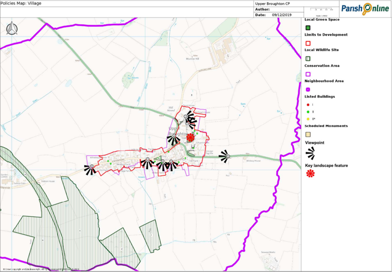
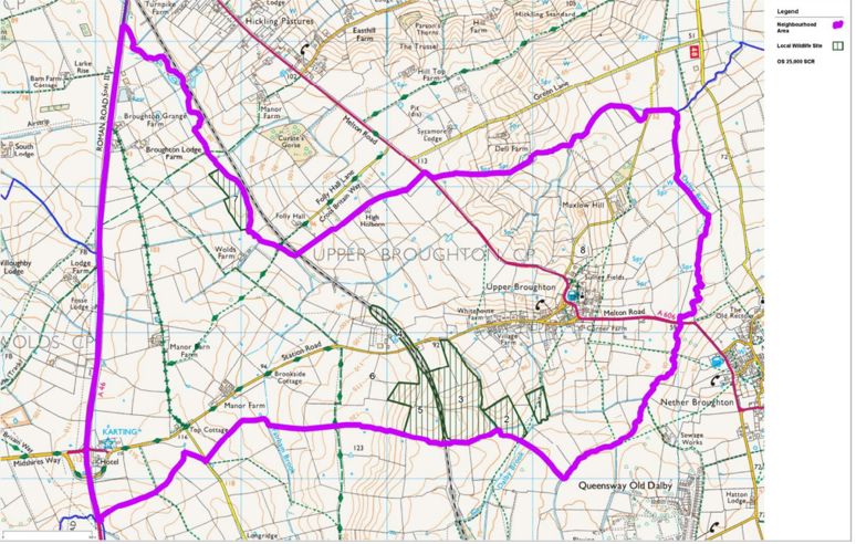
2.1 National policy makes provision for local communities to identify green areas of importance to those communities, where development will not be permitted except in very special circumstances. A full assessment of potential Local Green Spaces has been undertaken and their importance is summarised in Appendix 2.
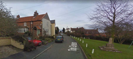
2.2 Of particular importance are the two small village greens at either end of Top Green which provide key focal points in the village with Bottom Green containing the remains of a historic stone cross. The results of our 2017 Questionnaire, showed that around 97% wanted to see Top (Daffodil) and Bottom (Cross) Greens protected. Over 50% of respondents wanted to see all six green areas
protected.
2.3 With the exception of St Luke's churchyard and the burial ground at the Baptists Chapel, which are consecrated land, these areas are already registered as common land and so various rights and restrictions already apply.
Policy UB1: Local Green Spaces
The following sites have been designated as Local Green Spaces:
- Top/Daffodil Green
- Bottom/Cross Green
- St Luke’s churchyard
- Land in front of Mill House
- Land fronting the South side of Chapel Lane and also between the North side of the A606 and the boundary fence of The Paddock
- Land in front of Hill Farm
- Burial ground of the former Baptist Chapel
Development that would harm the openness or special character of a Local Green Space (as designated on the Polices Map) or its significance and value to the local community will not be permitted unless there are very special circumstances which outweigh the harm to the Local Green Space.
- Important open spaces and views are protected
- Heritage is conserved
- The character and beauty of the countryside is safeguarded
Important Views
2.4 We want to protect the views of the surrounding countryside and we identified some of the key views in our 2017 questionnaire. A full assessment of important local views has been undertaken and this is summarised in Appendix 3.
2.5 Open space and gaps between properties to the south of Station Road provide a strong visual link with the surrounding agricultural land and beautiful views of the Belvoir escarpment, whilst the flanks of the hill to the north of the village provide a backdrop of grassy slopes and mature trees. Elsewhere the A606 Melton Road sweeps downhill through the eastern part of the village, its many turns providing a pleasing sequence of views.
2.6 St Luke’s Church tower is a local landmark that contributes to the historic character and scenic quality of the area and it important that it remains the key landmark feature.
Policy UB2: Locally Important Views
Development proposals should respect the open views and vistas as shown on the Policies Map and set out in Appendix 3. Proposals which would have a significantly detrimental impact on these views and vistas will not be supported:
- From Colonel's Lane looking east
- From the north of Church Lane towards the north-east
- Views of the village from the A606
- Views of Top Green from the A606
- From Bottom Green, opposite the Old Saddlery, looking south
- From Bottom Green, either side of The Barn, looking south
- From Station Road, across the tennis courts, looking south
- From the western edge of the village looking south and west
- Other open space and gaps between properties to the south of Station Road
Development should protect views of St Luke's Church.
- Important open spaces and views are protected
- Heritage is conserved
- The character and beauty of the countryside is safeguarded
3. Traffic and Parking
3.1 Traffic (particularly HGVs), road safety, speeding and inconsiderate parking were all concerns for local people. Many of these issues are outside the scope of the Neighbourhood Plan and are set out at Appendix 1.
Traffic
A606 Melton Road
3.2 There are particular concerns about traffic speeds through the village on the busy A606 Melton Road. On a scale of 0 to 10, (where 0 is not a problem) on average respondents to our 2017 survey scored speeding traffic on the A606 through the village as 8. There have been ten recorded accidents along this stretch of road over the period 2013-2017, including five serious accidents- two of which were
within the village.
3.3 The Highway Authority, Nottinghamshire County Council, has looked at different traffic management options in the past, but none have progressed.
Station Road
3.4 Around 70% of respondents to our 2017 Questionnaire identified other areas where speeding traffic was a concern. All of them
identified a problem on Station Road. Residents have also expressed concern over Station Road being used as a rat-run between the A606 and A46.
Parking
3.5 Just over a half (52%) of the respondents to our 2017 Questionnaire said that they had not experienced problems associated with inconsiderate parking. Those that did, identified car parking problems associated with Top and Bottom Greens, the church, village hall and tennis club. There were also concerns about cars obstructing the pavement throughout the village.
4. Services, Facilities and Infrastructure
4.1 The National Planning Policy Framework promotes the retention and development of local services and community facilities in villages, such as local shops, meeting places, sports venues, cultural buildings, public houses and places of worship. However, the provision of such services and facilities in Upper Broughton is limited. There is a church, the Tap & Run Public House, village hall, a cricket club and a tennis club.
4.2 Upper Broughton is served by the Centrebus Number 19 bus service between Nottingham and Melton Mowbray. This is a two-hourly, daytime service with no evening nor Sunday service.
4.3 Our 2017 Questionnaire showed that most (78%) local people would like to see a general store and 67% wanted to see better bus services.
4.4 The loss of even the limited services and facilities that residents currently enjoy can have a significant impact on people’s quality of life and the overall viability of the community. With an increasing proportion of older people in the population, access to locally based services will become increasingly important due to lower mobility levels. Almost all the respondents (97%) to our 2017 Questionnaire supported the retention of services and facilities.
Policy UB3: Community Services and Facilities Development that would result in the loss of the Tap & Run Public House, Cricket Club, Tennis Club or Village Hall will not be supported, unless it can be demonstrated that:
- All reasonable efforts have been made to preserve the facility, but it has been demonstrated that it would not be economically viable, feasible or practicable to retain the building for its existing use;
- The property has been marketed for a 12 month period and that there is no realistic interest in its retention for the current use or for an alternative community use; and
- It is no longer needed by the local community or that the facility is being replaced by equivalent or better provision in terms of
quantity, quality and location.
- Local services and facilities are retained
Tap and Run Public House
4.5 The site of today’s pub is shown as being occupied on the map of the village dated 1818, and it is believed that it was trading as a pub at that time. The site was redeveloped at some point later in the 19th century to largely the built form seen today.
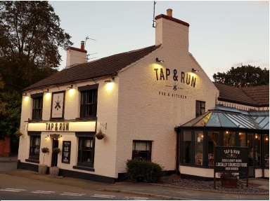
4.6 It traded for many years under the name ‘The Golden Fleece’. It closed in 2017 for major refurbishment works, which were completed in September 2018 when it reopened under the current name of the Tap & Run.
4.7 The Tap & Run is the only retail outlet left trading in the village and following the high-quality refurbishment of the pub it is hoped that it will again become a focal meeting point for the villagers of Upper Broughton.
Upper Broughton Cricket Club
4.8 The cricket club owns its own ground, on the A606 a hundred metres south of the village. The ground is very well maintained by the chairman and long-time resident of Upper Broughton, Alan Bailey, who has been a mainstay of the club for over fifty years. He is helped in this task by four or five other players. Between 1950 and 1995 Upper Broughton were a successful team playing in local village leagues, both at the weekends and latterly as an evening league side. However, since 1996 insufficient numbers have been available to field a full eleven on Saturdays and the team has had to withdraw from the Notts Amateur Cricket League, though the evening league team is still playing. At the weekend the ground is still well used, being let out as a facility to a club that is currently without a home pitch and staging around 50 games a year. With the facility in good order, it is still hoped and planned that more players can be attracted to the club, and thus maintain the well-established contribution of this local community asset.
Upper Broughton Tennis Club
4.9 Upper Broughton tennis club, formally Upper Broughton Youth and Social Club, was established in 1952. It was built by members of the village on land donated by a neighbour. The club membership in 2017 was its highest ever, at 80 adults and 60 juniors. Junior tennis is a particular interest, and organised coaching continues to be provided for them throughout the year. The facilities are two courts, in a rural setting. The beautiful view from south east to south west is an especial joy, enjoyed by all, and is a key feature of the offering.
New all-weather carpet courts were installed in 2013, followed by low cost but effective floodlights in 2017. The club thus provides a facility that is enjoyed by a wide range of local players throughout the year.
Upper Broughton Village Hall
4.10 Upper Broughton Village Hall was built in 1899. Over the years it has been maintained and modernised to a high standard and includes a fully equipped kitchen. Adjoining the Village Hall there is a cottage used by the Parish Council for meetings and other lettings like the Art Class and Tapestry Group. The main hall is used for weekly Yoga Classes and a Mothers and Babies Group. It is also used by the History Group and for Business Meetings, Coffee Mornings, Social Events and Children’s Parties. It hosts the Village’s Harvest Lunch, Upper Broughton Youth & Social Club Dinner, the Senior’s Lunch, and the Annual Art Show which is now in its 36th year.
Infrastructure
4.11 Developers may be asked to provide contributions for infrastructure in several ways. This may be by way of the Community Infrastructure Levy and planning obligations in the form of section 106 agreements and section 278 highway agreements. Developers will also have to comply with any conditions attached to their planning permission. We must ensure that the combined total impact of
such requests does not threaten the viability of the sites and scale of development identified in our Plan.
4.12 There are specific circumstances where contributions for affordable housing and tariff style planning obligations (section 106 planning obligations) should not be sought from small-scale and self-build development. As we are not planning for anything other than small-scale development, our Plan does not set-out policies for seeking planning obligations towards infrastructure provision.
5. Heritage and Design
Historical Development
5.1 Upper Broughton was Broughton Sulney for official purposes until the end of the 19th century and remains so ecclesiastically. The name Over Broughton has been used as far back as 1400 to distinguish the village from Nether Broughton.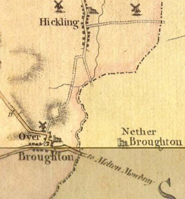
5.2 Historically, Upper Broughton has been a farming community, and the ridge and furrow of the communal fields of the middle ages has been evident until recently. The manor was sold by the Clifton family in 1623, though there seems to have been some land in other hands before that time. After 1623 the diversification of land ownership seems to have increased, though Parliamentary Enclosure of the entire parish did not take place until 1760. Most of the present fields and hedges were laid out at this time, and over the next 50 years outlying farmhouses were built. The original village may date from the late 9th century and was sited around the stock well, which is opposite the Golden Fleece. The village seems to have been extended westwards at the beginning of the 13th century, possibly as a result of an attempt to start a market at Cross Green. The former ‘main’ road through the village ran along Bottom Green and Station Road, and much of the present A606 was not constructed until the end of the 17th century. The location of the village is dictated by water sources, from the base of the glacial till at the top of the village, and from a sandy layer in the Lias lower down.
5.3 Many houses appear to date from the early 18th century, but there is widespread evidence of earlier buildings which have been rebuilt or more commonly re-faced in brick later. Several buildings have timber frames or traces of frames. Many buildings show evidence of their former thatched rooves being raised once tiles became available. Some slate rooves may date from the arrival of the
Grantham Canal at the end of the 18th century. Post-enclosure, three farmhouses were rebuilt or extended according to ‘pattern book’ designs (as statements of wealth and fashion), though the majority of buildings follow the vernacular design of the East Midlands. There was some redevelopment and gentrification of houses to accommodate wealthy commuters from Nottingham when the railway came in 1880. There was very little further development until the second half of the 20th century, when mains drainage and water became
available.
5.4 To the west of the village is the former Midland Railway route which linked Nottingham and Kettering. The line was opened for goods traffic in November 1879 and for passengers in February 1880. It was closed in 1968 and today it is used as a rail test track. The line would have supplied the Welsh slate which is commonly used for roofing in the village.
Listed Buildings
5.5 A listed building is a building which has been designated because of its special architectural or historic interest. The older a building is, the more likely it is to be Listed. All buildings built before 1700 which survive in anything like their original condition are Listed, as are most of those built between 1700 and 1840.
- Grade I buildings are of exceptional interest, nationally only 2.5% of Listed buildings are Grade I
- Grade II* buildings are particularly important buildings of more than special interest; 5.5% of Listed buildings are Grade II*
- Grade II buildings are of special interest; 92% of all Listed buildings are in this class and it is the most likely grade of listing for a home owner.

5.6 There are 16 Listed buildings in Upper Broughton. The Church of St Luke is the only Grade I Listed Building, all the rest are Grade II. The Church is mostly 13th Century, with 14th Century work in the tower. Remains of the south arcade from 1200 can also be seen. It is constructed from a buff coloured sandstone which has weathered substantially in certain areas. Of interest in the porch is a carving,
which shows St Oswald, king and martyr. This appears to pre-date the present building. It seems to have been a Calvary from the chancel arch which was evicted in a fit of Protestantism in 1733.
Scheduled Monuments
5.7 Scheduling is shorthand for the process through which nationally important sites and monuments are given legal protection. There is one Scheduled Monuments in Upper Broughton although there is also a Scheduled Saxon cemetery south-west of Broughton Lodge on the western boundary of the parish
The Village Cross
5.8 The cross on Cross Green is likely to have been a market cross of circa 1240. The remains comprise a base of two steps beneath a moulded pedestal and square socket stone surmounted by the lower portion of a square sectioned shaft. Originally the shaft would have been at least twice its present height and would have been surmounted by a carved cross head, but these items are now missing. The cross is also Listed Grade II.
Upper Broughton Conservation Area
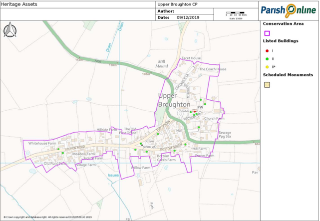
5.9 A conservation area is an area which has been designated because of its special architectural or historic interest, the character or appearance of which it is desirable to preserve or enhance. The Upper Broughton Conservation Area was designated in 1973 and includes nearly all the built-up area of the village and many of the immediately adjoining open spaces.
5.10 Buildings within the village are loosely grouped but harmoniously linked by walls, fences, mature hedges and trees. Typical of South Nottinghamshire, the predominant building materials are red brick walls and slate or clay pantile roofs.
Local Heritage Assets
5.11 There are buildings and sites in the parish that make a positive contribution to local character and sense of place because of their heritage value. Although such heritage features may not be nationally designated, they may be offered some level of protection through the Neighbourhood Plan.
Policy UB4: Local Heritage Assets
In considering planning applications which directly or indirectly affect non-designated heritage assets, a balanced judgement will be required having regard to the scale of any harm or loss and the significance of the heritage asset.
- Heritage is conserved
Design
5.12 We expect all development to contribute positively to the creation of well-designed buildings and spaces. Through good design we want to maintain and enhance the unique character of Upper Broughton and create places that work well for both occupants and users and are built to last.
5.13 The results of our 2017 Questionnaire show that 83% of respondents wanted to see design guidance included in our Neighbourhood Plan. Based on the Upper Broughton Conservation Area Appraisal and Management Plan, we have prepared design
guidance (Appendix 4) which describes the distinctive character of Upper Broughton and highlights the qualities valued by its residents. From these qualities, design principles, based on the distinctive local character of the village, have been drawn up to guide development.
Policy UB5: Local Design and Amenity
All new developments should reflect the distinctive character of Upper Broughton or be of exceptional quality or innovative design. Development should reflect the guidance set out in the Design Statement (Appendix 4). Development must also:
- Be in keeping with the scale, form and character of its surroundings unless smaller scale development is required to conform to
Policy UB13; - Protect important features such as traditional walls, hedgerows and trees;
- Not result in the loss of residential garden space to the detriment of the character of the village;
- Not significantly adversely affect the amenities of residents in the area, including daylight/sunlight, privacy, air quality, noise and
light pollution; - Not significantly increase the volume of traffic through the village; and
- Have safe and suitable access.
- Heritage is conserved
- Important open spaces and views are protected
6. Rural Character
6.1 Upper Broughton is a rural parish consisting of largely undeveloped open, pastoral farmland.
6.2 Local people value the intrinsic character and beauty of the countryside. Maintaining the character of the landscape, wildlife habitats, trees and hedgerows, and village boundaries are extremely important to local people as they help to preserve the rural characteristics of the area.
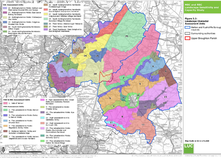
Landscape Character
6.3 The Greater Nottingham Landscape Character Assessment (2009) provides a county-level classification of landscape character types and areas across six local authority areas, including Rushcliffe, set broadly within the framework of National Character Areas. Five landscape character areas have been identified within Rushcliffe Borough, which are sub-divided into 14 Draft Policy Zones (DPZs). The east of the parish, including Upper Broughton village, lies in the Vale of Belvoir Draft Policy Zone. However, most of the parish lies in the Nottinghamshire Wolds: Widmerpool Clay and Vale of Belvoir Draft Policy Zones.
Vale of Belvoir
6.4 The Vale of Belvoir is an area of natural beauty on the borders of Leicestershire, Nottinghamshire and Lincolnshire in England. The name derives from the Norman-French for ‘beautiful view’. The Vale has a predominantly flat, low-lying landform with very gentle undulations, enclosed by rolling hills such as the Belvoir Ridge in Leicestershire to the south. The Grantham Canal is a local feature and an ongoing restoration project.
6.5 Upper Broughton village is located on the southern slope of a broad hill facing the Belvoir escarpment.
6.6 The Vale of Belvoir has a mostly remote, tranquil and undeveloped character, with occasional views to scattered villages and individual farms. The main land use is a mix of arable and pasture. There is a tradition of dairy farming in the area and the Vale is
the historic centre for Stilton cheese production.
Nottinghamshire Wolds: Widmerpool Clay Wolds
6.7 The Widmerpool Clay Wolds has a rolling landscape which forms part of a wider glacial plateau of chalky boulder clay overlying lower lias and Rhaetic beds. Undulations in the landscape are formed by small streams and tributaries which have cut through softer mudstones and clays. The area has a remote rural character.
6.8 There are several small nucleated villages which have a remote and rural character with concentrations of distinctive vernacular buildings. Farm buildings are frequent within the landscape, often containing a large red brick and pantile roofed farmstead with modern timber or metal outbuildings.
The Countryside
6.9 The countryside that we enjoy is managed by farmers and other land managers. They look after the environment through activities such as woodland and hedgerow management, conserving and restoring wildlife habitats, preserving features of importance to the local
landscape and maintaining drainage systems. The rural setting is highly valued by local people so, within the countryside, development will be limited to agriculture, forestry, recreation, tourism and other developments that are suitable for a rural location in accordance with Rushcliffe Local Plan Part 2 Policy 22.
Policy UB6: Countryside
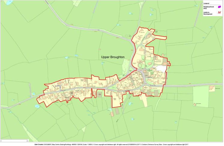
For the purposes of Rushcliffe Local Plan Part 2 Policy 22, the Countryside is land outside the Upper Broughton Limits to Development as defined on the Policies Map.
- Important open spaces and views are protected
- The character and beauty of the countryside is safeguarded
Renewable Energy
6.10 Increasing the amount of energy from renewable and low carbon technologies will help ensure the UK has a secure energy supply, reduce greenhouse gas emissions to slow down climate change and stimulate investment in new jobs and businesses. Planning has an important role in the delivery of new renewable and low carbon energy infrastructure in locations where the local environmental impact is acceptable.
Solar Farms
6.11 Solar farms (sometimes known as solar parks or solar fields) are the large-scale application of solar PV panels to generate green, clean electricity at scale, usually to feed into the grid or local distribution system. Solar farms can cover anything between 1 acre and 100 acres or more. In our 2017 Questionnaire, 41% of respondents supported solar farms.
Wind Energy
6.12 One of the key factors determining the acceptability or otherwise of wind turbines is their potential impacts on the local landscape – this is due to their height and the movement they introduce into the landscape (i.e. rotating blades). In June 2015, Rushcliffe Borough Council adopted a Wind Energy Supplementary Planning Document that assists the interpretation and application of those policies within the Core Strategy that concern wind turbine proposals. The Supplementary Planning Document refers to the Melton and Rushcliffe Landscape Sensitivity Study (MRLSS) as important in determining the acceptability of different types of wind turbine development within
the Borough. The landscape sensitivity assessment identifies that the Vale of Belvoir landscape is of low-medium sensitivity to turbines below 25 metres in height (to tip), of medium sensitivity to turbines between 26 metres and 50, of medium-high sensitivity to turbines between 50 and 74 metres and highly sensitive to turbines over 75 metres. It also notes that the landscape is likely to be highly sensitive to clusters of turbines over 3 in size. The Widmerpool Clay Wolds landscape is of low to medium sensitivity to turbines below 25 metres in height (to tip), of medium sensitivity to turbines between 26 metres and 75 metres, of medium-high sensitivity to turbines between 76 and 110 metres and highly sensitive to turbines over 111 metres. The Widmerpool Clay Wolds landscape is likely to be
highly sensitive to clusters of more than two to three turbines.
6.13 National planning policy now allows local people to have the final say on wind farm applications. When determining planning applications for wind energy development involving one or more wind turbines, local planning authorities should only grant planning permission if the development site is in an area identified as suitable for wind energy development in a Local or Neighbourhood Plan. In our 2017 Questionnaire, only 24% of respondents supported wind turbines.
Biomass
6.14 The term "biomass" refers to organic matter that has stored energy through the process of photosynthesis. It exists in one form as plants and may be transferred through the food chain to animals' bodies and their wastes, all of which can be converted for everyday human use through processes such as combustion, which releases the carbon dioxide stored in the plant material. Many of the biomass fuels used today come in the form of wood products, dried vegetation, crop residues, and aquatic plants.
6.15 The John Brooke Sawmills site on the A46 contains a seven-megawatt wood-fuelled biomass plant.
Microgeneration Technologies
6.16 Many microgeneration technologies projects, such as domestic solar PV panels, ground source and air source heat pumps are often permitted development which means they do not require planning permission providing certain limits and conditions are met. Most of the respondents to our 2017 Questionnaire (81%) supported small-scale renewable energy technologies.
Policy UB7: Renewable Energy
Ground-mounted solar photovoltaic farms will only be supported where:
- Their location is selected sensitively and well planned so that the proposals do not impact on any features of local heritage or wildlife interest;
- The proposal’s visual impact has been fully assessed and addressed in accordance with Planning Practice Guidance on landscape
assessment (Planning Practice Guidance ref: 5-013-20150327); and - The installations are removed when no longer in use.
Proposals for wind turbines over 25 metres in height would not be supported. Proposals for wind turbines of a height less than 25 metres may be considered suitable if:
- Following consultation with the local community it can be demonstrated that any planning impacts have been fully addressed; and
- The proposal has the backing of the local community.
- The character and beauty of the countryside is safeguarded
Ecology and Biodiversity
6.17 Although there are no nationally designated ecology sites, there are several wildlife sites in Upper Broughton.
6.18 The Neighbourhood Plan provides an opportunity to protect other broad habitat types, such as other wetlands, grasslands and woodland. 92% of respondents to our 2017 Questionnaire thought that our Neighbourhood Plan should identify, protect and where possible enhance local biodiversity.
Local Wildlife Sites
6.19 Local Wildlife Sites (previously known as Bio Sincs) are identified and selected locally using robust, scientifically-determined criteria and detailed ecological surveys. These special and often secret spaces have a huge part to play in the natural green fabric of our countryside. There are eight Local Wildlife Sites in Upper Broughton:
- Upper Broughton Meadow II: A fine neutral grassland
- Upper Broughton Meadow: A well-established and locally characteristic grassland community
- Upper Broughton Pasture: A sequence of species-rich unimproved grasslands
- Railway, Upper Broughton: A valuable railway containing calcicolous species
- Upper Broughton Meadows: Traditionally managed species-rich unimproved grasslands
- Upper Broughton Pond
- Broughton Wolds Grasslands: A series of species-rich neutral grasslands
6.20 Additionally, Upper Broughton lies within the South Rushcliffe Pondscape focal area identified within the Rushcliffe Biodiversity Opportunity Mapping Report. The Parish is therefore important for ponds, a habitat of particularly important for great crested newts (great crested newts are a protected species and have been recorded within the parish and in neighbouring Nether Broughton).
6.21 Opportunities within the parish to maintain and enhance existing ponds and create new ponds to improve connectivity across the landscape should be considered. Other wetland and grassland linkages should also be retained and developed along with farmland habitats (field margins, arable flowers etc.).
Policy UB8: Ecology and Biodiversity
- The following Local Wildlife Sites are defined on the Policies Map: Upper Broughton Meadow II
- Upper Broughton Meadow
- Upper Broughton Pasture
- Railway, Upper Broughton Standard Meadow
- Upper Broughton Meadows
- Upper Broughton Pond
- Broughton Wolds Grasslands
- Upper Broughton Pond
Development likely to have a significant adverse effect on the Local Wildlife Sites and other valuable local ecological features and habitats will be considered by the methodology expressed in Policy 36 of the Local Plan Part 2.
New development will be expected to provide net gains for biodiversity for example by:
- Enhancing existing ecological corridors and landscape features (such as watercourses, grassland, hedgerows and tree-lines) for
biodiversity; - Enhancement of existing and creation of new ponds;
- Incorporating built-in bat and bird boxes into buildings; and
- The inclusion of Sustainable Urban Drainage System components that make a significant contribution to biodiversity.
- Important open spaces and views are protected
- The character and beauty of the countryside is safeguarded
Trees and Hedges
6.22 Mature trees and hedgerows play an important part in the character of Upper Broughton. Along Melton Road they greatly enhance the rural approaches to the village centre. Throughout the village, many properties are hidden behind established hedgerows and banks of trees.
6.23 Most of Upper Broughton village lies within a Conservation area and consequently, any tree over 75mm in diameter at 1.5m above ground level is given automatic protection. No cutting, removal, wilful damage or destruction of such trees is allowed without giving prior notification to Rushcliffe Borough Council.
6.24 Most (98%) of the respondents to our 2017 Questionnaire wanted to see important trees in Upper Broughton protected.
Policy UB9: Trees and Hedges
Development that damages or results in the loss of ancient trees, or hedgerows or trees of good arboricultural and amenity value, will not be supported. Proposals should be designed to retain ancient trees, or hedgerows or trees of arboricultural and amenity value as they help to define the character of the area. Planning applications affecting trees or hedgerows should be accompanied by a tree survey that establishes the health and longevity of any affected trees and indicates replanting where appropriate. Replanting should be with native species of local origin and provenance.
- Important open spaces and views are protected
- The character and beauty of the countryside is safeguarded
7. Housing
Local Plan Part 1: Core Strategy
7.1 The Upper Broughton Neighbourhood Plan must be in general conformity with the strategic policies of the Rushcliffe Core Strategy. and it should not promote less development or undermine its strategic policies.
7.2 The Core Strategy plans for 13,150 new homes over the period 2011 to 2028. Most of this new development is directed to the edge of the built-up area of West Bridgford and the Key Settlements of Bingham, Cotgrave, East Leake, Keyworth, Radcliffe on Trent and Ruddington.
7.3 The Local Plan Part 2: Land and Planning Policies Document will set out the non-strategic development allocations and detailed policies for managing new development, following on from the strategic framework set out in the Core Strategy. Rushcliffe Borough Council have now identified where more homes should be built and consulted on these proposals in Autumn 2017. The sites, which
in total would deliver over 2,500 new homes, are at the following locations: Bunny, Cotgrave, Cropwell Bishop, East Bridgford, Gotham, Keyworth, Radcliffe on Trent, Ruddington and West Bridgford.
7.4 Upper Broughton is not expected to accommodate development other than to meet local needs.
Meeting Local Housing Needs
7.5 Since 2011, five houses have been built (net of demolitions) in the Parish (to 31st March 2017) and a further three homes had planning permission. Of these eight new homes, six had four bedrooms or more.
7.6 In our 2017 Questionnaire, we invited local people to set out how many new homes we should plan for. The majority of respondents indicated between 1 and 10 (1 to 5 = 38% and 6 to 10 = 29%).
7.7 We also asked existing households to identify any housing needs that they expected to have over the coming ten years. In Upper Broughton, 13 households said that someone in their household would need to move. 77% wanted a two or three bed house. Five wanted to move because their existing house was too large, four were from young people looking to live independently. In most cases
these needs could be met by market housing or self-build housing. Only two were interested in Local Authority or Housing Association housing.
7.8 Not all this housing need must be met in Upper Broughton. Some younger people will move away for work or to study, while housing for older people could free-up existing homes for new households. Nonetheless, up to ten new homes are needed and our 2017 Questionnaire shows that many local people support small-scale development.
7.9 We also asked local people how we should plan for housing growth. There was good support for the conversion of rural buildings, brownfield and infill development.
7.10 To meet the need for new homes, our Plan allows for the conversion of existing rural buildings and infill housing development. To clarify where infill development would be acceptable, our Neighbourhood Plan defines Limits to Development for Upper Broughton village which takes account of the character the village. In the remainder of the Parish new residential development will normally be limited to the conversion of existing buildings.
Policy UB10: Housing Provision
Applications for housing development within the Upper Broughton Limits to Development, as defined on the Policies Map, will be supported subject to meeting the other policies of the Neighbourhood Plan.
Outside the Upper Broughton Limits to Development, permission for housing development will be limited to:
- The re-use and adaptation of redundant rural buildings in accordance with Policy UB11; and
- Replacement dwellings in accordance with Policy UB12.
- Housing development reflects local needs
Residential Conversion of Rural Buildings
7.11 On 6 April 2014, new permitted development rights were introduced which allow for the conversion of agricultural buildings to dwellings without the need for planning permission. However, various conditions and restrictions apply and before starting development, there is a requirement to submit an application to the local planning authority for prior approval. The rules mean that not all rural buildings benefit from these permitted development rights so, in accordance with local support, our Plan provides further flexibility for the conversion of rural buildings to residential use.
7.12 Many buildings in the countryside are attractive, frequently constructed from local materials and often reflect the local vernacular, which in turn contribute significantly towards the character and diversity of the Parish. The conversion of these rural buildings to provide new homes can make the best possible use of existing buildings and reduce the demand for new buildings in the countryside.
7.13 Not all buildings in the countryside are suitable for conversion or adaptation to housing as they may be of modern materials, poorly designed or constructed. Redundant buildings proposed for re-use should be structurally sound to ensure they are able and appropriate for conversion. This should be demonstrated through an up to date structural survey submitted with any planning application.
Demolition should be avoided to retain the character of traditional buildings.
7.14 Any extensions or alterations should respect the form and character of the existing building and not extend beyond the existing curtilage. Modern additions which detract from the scale and form of the existing building will be resisted.
Policy UB11: Residential Conversion of Rural Buildings
The re-use and adaptation of redundant or disused rural buildings for residential use will be supported where:
- The building is structurally sound and capable of conversion without significant rebuild or alteration;
- The development will maintain the character of the building, including the retention of important features;
- The use of the building by protected species is surveyed and mitigation measures are approved where necessary; and
- Any proposed extension(s) or alterations are proportionate to the size, scale, mass and footprint of the original building and situated within the original curtilage.
- Heritage is conserved
- The character and beauty of the countryside is safeguarded
Replacement Dwellings
7.15 It is recognised that the replacement of a dwelling in the rural area can result in significant benefits to the local area. It can lead to improved architectural appeal and modern design and construction standards leading to better energy efficiency. It can also overcome poor construction techniques employed with the original dwelling and can provide accommodation and facilities which more appropriately accord with modern life.
7.16 Due to these significant potential benefits, where development would result in an enhancement to the area, replacement dwellings in the rural area will often be acceptable. However, where dwellings are replaced, the new dwelling should be sympathetic to the size and appearance of the original. Modest increases in size from the original dwelling will normally be acceptable but we are keen to ensure that the limited stock of small and single-storey housing is not reduced. It is also important that the replacement dwelling is compatible with its surroundings in terms of size, scale, mass and footprint and sited within the pre-existing residential curtilage. To manage the future impact on the landscape and rural character of the area, it may be necessary to impose a condition to the planning permission to remove permitted development rights to prevent replacement dwellings from being extended disproportionately in the future.
7.17 Any proposals to replace a dwelling should not lead to an increase in the number of residential units on the site. Conditions will be attached to any planning permission for replacement dwellings to ensure that demolition of the existing dwelling is carried out.
Policy UB12: Replacement Dwellings
Outside Limits to Development proposals for the demolition and rebuild of an existing dwelling will be supported where:
- It leads to an enhancement of the immediate setting and general character of the area;
- It does not lead to a reduction in the stock of smaller or single-storey dwellings;
- The new dwelling is proportionate to the size, scale, mass and footprint of the original dwelling and situated within the original
curtilage.
- Housing development reflects local needs
- The character and beauty of the countryside is safeguarded
Housing Mix
7.18 In planning for new homes, the type of housing should meet the needs of people living locally. New housing should take into consideration the housing profile of the area and the views of local people:
- There is already a high proportion of detached dwellings - 68% of dwellings in the Parish are detached compared with 46% in Rushcliffe Borough and 22% in England (2011 Census).
- Significant levels of under-occupancy currently exist - 63% of dwellings in the parish have an occupancy1
rating of 2+ compared with 50% in Rushcliffe Borough
and 34% in England (2011 Census). - House prices are high - The average property value in Upper Broughton is £510,187 compared with £380,049 in Nether Broughton, £306,979 in Old Dalby and £393,547 in Hickling (Zoopla December 2017)
- The people in need want smaller houses - 38.5% of households needing to move within the Parish within the next ten years’ say they need a 2 bed property and 38.5% want a 3 bed home.
- Local people would like to see a mix of housing types and sizes - Responses to our 2017 Questionnaire showed that the
top three priorities for new housing were:- 3bed houses (e.g. for families with children)
- 2bed houses (e.g. for couples, smaller families, single parents, singles with child access and frequent visitors)
- 2/3bed bungalows for downsizing older people
7.19 Upper Broughton Council will review the evidence of housing need once local data from the 2021 Census has been published and thereafter every five years to ensure that the Plan continues to meet the needs of people living locally. Evidence of a significant change in circumstance may trigger a full or partial review of the Plan.
7.20 In 2015, the Government published nationally described space standards. Using these standards, we would expect the Gross Internal (floor) Area of a new, three-bed house to be 84-102 square metres. Larger homes should only be allowed in exceptional circumstances.
Policy UB13: Housing Mix
Applicants for the development of new dwellings will need to demonstrate how their proposals will meet the housing needs of older households and/or the need for smaller, affordable homes for sale or rent. The development of housing with four bedrooms or more will only be supported if:
- It is demonstrated that the development would otherwise be undeliverable; or
- It is necessary to make best use of a redundant or disused rural buildings in accordance with Policy UB11.
- Housing development reflects local needs
Affordable Housing
7.21 Affordable housing is housing for sale or rent, for those whose needs are not met by the market (including housing that provides a subsidised route to home ownership and/or is for essential local workers). Affordable housing can include affordable housing for rent, starter homes, discounted market sales housing and other affordable routes to home ownership.
7.22 Our 2017 Questionnaire identifies a need for local housing, but this need can largely be met by market housing. The need for Local Authority or Housing Association property to rent or for shared-ownership was just two homes. The limited need for additional affordable homes means that there is no immediate requirement to allow planning permission to be granted for affordable housing on
a ‘Rural Exception Site’, i.e. a site that would not normally be released for private market housing. In our 2017 Questionnaire, 54% of respondents said that they would not support a Rural Exception Site for affordable housing.
8. Employment
Economic Activity
8.1 The 2011 Census shows that of the 234 parish residents aged 16 to 74, 172 were economically active. Of those economically active, 53% were in full-time employment, 23% were in part-time jobs and 24% were self-employed. In March 2017, the Job Seekers Allowance claimant count in Nevile ward (which includes Kinoulton, Owthorpe and Hickling) was 1.2%.
8.2 The 2011 Census shows that a particularly high proportion of working residents were managers, directors or senior officials– 38 people or 22.5% compared with 14% in Rushcliffe Borough.
8.3 Historically, agriculture provided the bulk of local employment and it remains part of village life and the local economy. However, in 2011 (Census) only 3% of the Parish’s workers were employed in agriculture, forestry or fishing.
8.4 Five local businesses responded to our 2017 Questionnaire. All these businesses were micro-businesses employing less than ten people. For all these businesses, their premises were also their home.
8.5 Although there is limited demand for new business space, nor many residents intending to set-up new businesses, we want to support small-scale economic growth in Upper Broughton to create jobs and prosperity, reduce the need for people to travel to work by car, and provide opportunities for the expansion and growth of local enterprise.
Home Working
8.6 Planning permission is not normally required to home work or to run a business from home, if a house remains a private residence first and business second. Rushcliffe Borough Council is responsible for deciding whether planning permission is required and will determine this based on individual facts. Issues which they may consider include whether home working or a business leads to notable
increases in traffic, disturbance to neighbours, abnormal noise or smells or the need for any major structural changes or major renovations. Our 2017 Questionnaire showed that 90% of respondents supported home working.
Business Conversion of Rural Buildings
8.7 We want to expand the diversity of the rural economy while preserving and enhancing the environment of the countryside. Our 2017
Questionnaire demonstrates that local people support (71% of respondents) the conversion of existing rural buildings to business use. However, the proposed uses must be appropriate in scale, form, impact, character and siting to their location in the countryside. To allow farming to accommodate change and support the rural economy our Plan gives more flexibility over the reuse of rural buildings
for business rather than residential purposes.
Policy UB14: The re-use of rural buildings for business use
The re-use, adaptation or extension of rural buildings for business use will be supported where:
- The existing buildings are suitable for the proposed new use(s);
- Any enlargement is proportionate to the size, scale, mass and footprint of the original building;
- The development would not have a detrimental effect on the fabric, character and setting of historic buildings;
- The development respects local building styles
and materials; - The use of the building by protected species is surveyed and mitigation measures are approved where necessary;
- The proposed development would not have an unacceptable impact on highway safety, or the residual cumulative impacts on the road network would be severe; and
- The proposed development would not materially harm the character of the surrounding rural area.
- Heritage is conserved
- The character and beauty of the countryside is safeguarded
- The parish is home to a range of small-scale businesses
A46 Businesses
8.8 There are a range of businesses and other activities located alongside the A46 on the western edge of the parish. Most are located on the A46/Station Road junction and include:
Prince Petroleum: fuel and oil supplies for domestic, commercial, industrial or agricultural use;
Vale Scaffold Services: scaffolding hire, erection and dismantling;
Nottingham Raceway Karting: one of the oldest established public karting tracks in the country;
Teen Challenge UK: a registered charity that helps individuals who have developed life controlling problems, especially drug and alcohol addictions.
As part of our strategy for generating new and better jobs for local people we want to support the retention and growth of these businesses.
Policy UB15: A46 Business Area
The A46 Business Area, as defined on the Polices Map, will be safeguarded for employment development (uses falling within class B of the Use Classes Order including offices (B1) manufacturing (B2) and small-scale warehousing and distribution (B8)). The expansion of existing businesses and the existing residential institution, together with new employment development within the A46 Business
Area will be supported.
- The parish is home to a range of small-scale businesses
Live/Work Units
8.9 Many people have historically had business premises and residential accommodation which are connected or attached in some way, such as homes with workshops attached and farmhouses. During more recent decades, due to changing employment and living trends, this has altered, and new developments are normally exclusively for either residential or employment purposes with people typically commuting from their home to their place of work.
8.10 However, changing patterns of employment in recent years together with improvements in information technology means that often people can work or operate a business without the need to travel to premises some distance away.
8.11 A live/work unit is a property that is designed primarily for employment purposes, but which also includes ancillary residential space connected to the employment premises. Live/work units allow more people to work from home, but we are keen to ensure that there are controls to prevent proposals becoming a wholly residential use.
Policy UB16: Live/Work Units
Within or adjoining the A46 Business Area, as defined on the Polices Map, Live/Work units will be supported where the ratio between living space and work space does not exceed 50:50. In addition conditions preventing sub-division and restricting residential occupation to those employed in the linked workspace will be imposed.
- The parish is home to a range of small-scale businesses
Nottingham Heliport
8.12 Further north along the A46 at Broughton Lodge Farm is the base for Central Helicopters. After starting out life predominantly as a flying school, Central Helicopters still trains students, but also provides pleasure flights, trial lessons and a broad selection of charter services. Despite local concerns about noise, planning permission was granted for the helicopter base (Ref: 12/01396/FUL) in 2012,
subject to a variety of conditions including restrictions on the number of flights, flight pattern and hours of operation.
8.13 Noise remains an ongoing issue for residents. Our 2017 Questionnaire showed that about half of respondents had concerns relating to helicopter noise and disturbance. It is the largest source of noise problems in the parish, despite the proximity of East Midlands Airport, the A46 and the rail test track.
8.14 John Brooke Sawmills is located directly east of the A46 and north of Nottingham Heliport. The site contains a seven-megawatt wood-fuelled biomass plant along with wood chipping, shredding, wood recycling and composting operations.
8.15 The combustion of waste wood generates heat which raises steam to turn turbines to produce electricity. The biomass plant operates 24 hours a day, subject to the availability of a constant fuel supply. However, all other operations associated with the biomass plant, such as the receipt of wood fuel, would place between 7am and 7pm Monday to Saturday and between 8am and 4pm on Sundays.
8.16 Waste development is explicitly excluded from the issues within the jurisdiction of a Neighbourhood Plan.
Appendix 1: Non-planning Issues
Introduction
1.1 The process of preparing the Upper Broughton Neighbourhood Plan has highlighted non-planning, local traffic and transport issues. Most of these matters were raised in response to the 2017 Questionnaire and are being considered by Upper Broughton Parish Council. They do not form part of the statutory Neighbourhood Plan, so are not subject to the independent examination nor referendum.
1.2 The clear opinion of local residents is that speeding traffic on the key roads through the village is detrimental to its peaceful character, rural setting and Conservation Area designation. Our contention is that the issues of speeding traffic along key roads in the village are material considerations that should not be overlooked when new development within the Parish, and in neighbouring areas, are considered through the planning process. As such we have sought to explore in greater detail and evidence (using survey response analysis and secondary data) the key transport issues and opportunities that might be pursued to improve the current situation and/or
prevent it from worsening.
Survey insights and other evidence
2.1 The impact of vehicular traffic on village life was identified as one of the three most important issues for the Neighbourhood Plan by over 60% of the 99 respondents to the survey. It was the second most frequently cited ‘key issue’ for the Neighbourhood Plan by people who live in the Parish, after protecting green areas in the village and local views.
The A606 through Upper Broughton
2.2 A total of 93 Neighbourhood Plan respondents identified speeding traffic on the A606 as a problem – rating it an average of ‘8 out of 10’ as an issue (where 0 = ‘no problem’). As shown in Figure 4, the A606 is a strategic local road that provides a link between Nottingham, Melton Mowbray and Oakham. Beyond Oakham, to the south, it also provides a secondary route between Nottingham
and the A1.
2.3 The A606 has a speed limit of 30 mph through the village, which is reasonably clearly signed on approaches from the north (from Nottingham) and south (from Melton Mowbray). There are modest entry treatments into the village, with a speed activated ’30mph – slow down’ sign on the northern approach to the village. Anecdotal evidence suggests a significant amount of traffic is still decelerating as it enters the village, in preparation for negotiating the series of bends that characterise the road’s presence through the village. These bends do, themselves, help to slow down approaching traffic as it enters the village from both north/south directions.
2.4 The A606 bisects well-established linear development to the west of the village (along Top Green / Bottom Green, which becomes Station Road as it heads out of the village towards the A46 and Willoughby) and concentrated development focused on Upper Broughton’s Church and the Golden Fleece public house. The A606 is crossed by four public footpaths (see Figure 7) that are popular with both villagers and ramblers visiting the area. They provide access to surrounding countryside, as well as traffic-free paths to
neighbouring villages of Nether Broughton, Old Dalby and Hickling.
2.5 In the centre of the village the A606 feels like quite a wide road, which may be a legacy of the swept path required for Heavy Goods Vehicles (HGVs), buses and other larger vehicles (e.g. agricultural machinery) to pass through the village at higher speeds. Approaching the Golden Fleece pub from the south, the carriageway is approximately 9.6 metres wide, which is substantially wider than might
typically be required in a 30-mph speed limit area (The Design Manual for Roads and Bridges specifies a standard width of 7.3 metres).
2.6 While the width of the carriageway at this point respects the presence of the village’s two bus stops, which are slightly offset (and visible in Figure 8), it also does little to discourage higher traffic speeds through the village and provides a wide crossing point for people to negotiate. The sight lines for pedestrians and drivers are also not ideal in this location, being a function of the A606’s alignment as it climbs towards the northern extent of the village - sweeping left, right and then left again to lessen the gradient.
Traffic flows
2.7 Automated traffic counts from 2016 estimate that the A606 carries a daily average of just over 5,000 vehicles, around 6.5% of which (320 vehicles per day) are HGVs. Although not inconsiderable, this is significantly less traffic than the A606 carries elsewhere along its length (~15,000 vehicles per day pass through Stanton-on-the-Wolds, to the north of the A46) and consistent with other rural A-roads elsewhere in South Nottinghamshire (7,300 vehicles per day pass through Rempstone close to the A6006 junction).
2.8 The five-day (weekday) average vehicle flow through Upper Broughton on the A606 is calculated at between 7am and 8am is 232 vehicles southeast bound, and 245 vehicles travelling northwest bound. Taken together, the total of 477 vehicles per hour passing through the village on the A606 during this AM peak hour substantially exceeds the 250 vehicles per hour flow that is one of the
requirements for traffic calming, based on criteria defined by Nottinghamshire County Council. However, the County Council’s Highway Network Management Plan states that “traffic calming will be introduced in urban areas in appropriate circumstance as a measure to reduce road accident casualties [and] assist accident reduction. In exceptional circumstances it may also be used to address community concerns arising from inappropriate speed or through traffic”. Unfortunately, there is little possibility of monies being spent on calming unless it offers a measurable benefit in terms of casualty reduction.
2.9 The Management Plan also suggests that calming should not be installed on primary routes. As the road connecting Nottingham and Melton, the A606 fall into this category.
Traffic speeds
2.10 The latest available traffic speed dataset for the A606 in Upper Broughton is less recent (dating from April 2008), and warrants updating. The available data, collected at Rectory Rd, suggest that over a 24-hour period:
- Around 10% of motorists are exceeding the 30mph speed limit on the A606 in Upper Broughton by an amount that would result in
enforcement action according to the Association of Chief Police Officer’s (ACPO) guidance. - Nottinghamshire County Council’s guidance on traffic calming suggests this figure needs to be over 50% of vehicle flow before traffic calming will be considered.
- Around 40% of motorists using the A606 through Upper Broughton exceed the speed limit by up to 10% (3 mph over the 30mph limit) which is typically below the threshold for a Fixed Penalty enforcement notice being issued.
Reported road traffic incidents and other safety concerns
2.11 Notwithstanding resident’s concerns over speeding traffic, there have been relatively few road traffic incidents in the last five years. In this time approximately 8-9 million vehicle trips will have been completed through Upper Broughton on the A606, which have yielded a total of seven accidents. While regrettable, in statistical terms this is understood to be broadly consistent with other A-roads of a similar nature in South Nottinghamshire.
2.12 Of the seven reported incidents, two were within the 30mph section of the village and both were classified as ‘serious’ .
2.13 One of these incidents (2D056616) involved a horse and cart, and resulted from the horse being spooked by a passing vehicle at the southern end of the village. The other (2D236514) resulted from a vehicle turning from the A606 (south-bound) into Top Green across the path of a vehicle coming around the bend. While the curves and limited sight lines into the village may have been a factor
in the second incident, these are not on their own likely to provide sufficient evidence to justify traffic calming measures. Perhaps critically, neither of the reported incidents involved pedestrians.
Station Road, Bottom Green and Top Green
2.14 Over 70% of respondents to the Neighbourhood Plan indicated that speeding road traffic is also perceived as a problem elsewhere in the village. A total of 65 responses indicated the locations where this is perceived to be a problem, and they almost universally identified some combination of Station Road, Bottom Green and Top Green.
2.15 Further context was provided in some responses, which highlighted perceived higher speeds of farm contractors driving larger agricultural/plant machinery and vehicles passing through the village to use Station Road as a point of access to the A46. A total of 93 people rated the issue of Station Road being used as a rat run between the A46 and A606 as an average of ‘7 out of 10’ (where 0 = ‘no
problem’). This suggests local residents consider the issue of speeding traffic along Station Road/Bottom Green/Top Green as marginally less significant than the issue of speeding traffic along the A606 through the village.
Traffic speeds and flows on Station Road
2.16 Data on traffic flows and speeds along Station Road were recorded at the western edge of the village, near its junction with Sulney Close, in December 2014. The counts found that the road is lightly trafficked, carrying an average of 1,000 vehicles per day, with the busiest times of day being 8am-9am (~90 vehicles in each direction) and between 4pm-6pm (~100 vehicles in each direction, per hour) on a weekday.
2.17 In speed terms, the surveys found that around a quarter of all vehicles travelling along Station Road at Sulney Close are doing so above the ACPO threshold for issuing a fixed penalty notice (~35mph). National guidance suggests that speed limits should not be lowered in an attempt to reduce speeds, as this approach general doesn’t work. If people are speeding when the limit is 30 mph, lowering the limit to 20 mph will likely result in more people speeding. Nonetheless, the County Council are obliged to consider all speed limit reduction requests if the Parish Council and the community want the speed limit lowering.
Reported road traffic incidents and other concerns
2.18 No road traffic incidents have been reported on Station Road, but just over half (52%) of respondents to the Neighbourhood Plan survey identified that inconsiderate or insufficient parking is a problem in Upper Broughton. Top Green and the Village Hall were the sites where greatest parking pressure appears to exist, but on-street and pavement parking were general concerns for village residents.
Locations identified as having parking issues (percentage of respondents)
- Top Green = 49%
- Village Hall = 21%
- Bottom Green = 12%
- On-road or pavement = 12%
- Church = 7%
- Chapel Lane = 7%
- Tennis Courts = 5%
2.19 Limited availability of off-street parking at homes along Top Green, a relatively narrow lane adjacent to the village green, is a key factor behind these responses.
Public transport links
2.20 Upper Broughton is currently served by the number 19 bus, operated by Centrebus. It runs Monday to Saturday between Nottingham (43-minute journey time) and Melton Mowbray (20 minute journey time) with five services in each direction per-day.
Holders of English National Concessionary Travel Scheme passes, which are available for older and disabled people, can travel for free on the bus service after 9:30am.
2.21 While a total of 67% of respondents would like there to be a better bus service to the village, the current service is understood to operate on a commercial basis- without subsidy from the County Council. In the current context of local government budget cuts and cost-saving activities, we recognise that improvements to existing service frequencies or services to new destinations (e.g. Loughborough /Leicester) are unlikely given the relatively small scale of the village.
Summary
2.22 There appears to be relatively limited scope for the Neighbourhood Plan to improve the identified parking issues on Top Green, aside perhaps from ensuring adequate off-street parking is provided for any new developments in this area of the village. However, the available evidence (although partially outdated at the time of writing) suggests that residents’ concerns over excess speeding on
the A606 and, particularly, Station Road, appear to be reasonably well-founded. In particular, the issue of traffic calming and speed reduction measures may warrant further consideration.
2.23 The table below compares the County Council’s traffic calming thresholds with key metrics discussed earlier in this section for the A606 and Station Road. It shows that while neither location in the village exceeds all of the risk factors that might automatically trigger the implementation of traffic calming measures, resident’s perceptions (as identified through the Neighbourhood Plan survey) are that the problem is greater than the quantitative evidence might suggest.
| Notts County Council traffic calming thresholds | A606 |
Station Road |
|---|---|---|
| Accident record within the village | 2 collisions in five years [Not met] | 0 collisions in five years [Not met] |
| Road category (calming on major roads only considered in response to accidents) |
Major road, but with 30mph section through village centre by pub [Not met] | Minor road [Met] |
| Vehicle flow over 250 vehicles during peak hour | 477 in the AM peak [Met] | 100 in PM peak [Not met] |
| Speed limit exceeded by 20% or more, by majority of peak vehicle flow | Around 10% of vehicles travelling over 36 mph [Not met] | Around 25% of vehicles travelling over 36 mph [Not met] |
| Houses front more than half of affected road | Houses and pub front road in village centre [Met] |
Houses front full extent of the road [Met] |
| Substantial public support for traffic calming measures |
Problem rated at 8/10 by all Neighbourhood Plan survey respondents [Met] |
Problem rated at 7/10 by survey respondents [Met] 70% identified Station Rd/ Bottom Green/ Top Green as places where |
2.24 In analysing these findings, it is important to note:
- The averaging of traffic speeds by the hour will mask some much higher actual speeds, by a small proportion of vehicles, which are anticipated to be the source of village resident’s concerns.
- Around half (50%) of all motorists passing through the village are doing so within the 30mph speed limit along the A606.
- The community facilities (pub, church, village hall, bus stops) and residential properties located along the alignment of the A606
through the centre of the village mean that perceptions of speeding and traffic flow are heightened in this location. - The configuration of the A606, with sharp bends on entry to the village from both the south east and north west directions, also
means that mean average speeds recorded for traffic flows in the village (30mph - 31mph) can also feel a lot quicker. However, the road configuration probably also serves to slow vehicle speeds through the village centre.
Key issues and opportunities
3.1 Drawing together the evidence discussed in this note, the table below sets out key transport issues and opportunities that could be explored through further work by Upper Broughton Parish Council in partnership with Nottinghamshire County Council:
| Issues | Opportunities |
|---|---|
| Outdated speed survey for A606/ no post-implementation survey for Station Road |
Collect and re-analyse fresh survey data to update the evidence base documented in this note |
| Insufficient level of accidents / speeding on the A606 and Station Road to warrant significant traffic calming measures |
More regular enforcement activity could Modest traffic calming measures could have significant impact Highway infrastructure may be out of |
| Perceptions of inconsiderate speeding on the A606 / Station Road and impact of HGV traffic passing through the village |
Subject to fresh speed survey data and
|
Appendix 2: Local Green Spaces: Summary of Reasons for Designation
| Reference | Local Green Space |
Holds a Particular Local Significance, Because of it's Beauty |
Holds a Particular Local Significance, Because of it's Historic Significance |
Holds a Particular Local Significance, Because of it's Recreational Value |
Holds a Particular Local Significance, Because of it's Tranquillity |
Holds a Particular Local Significance, Because of the Richness of it's Wildlife |
Holds a Particular Local Significance, For Any Other Reason |
|---|---|---|---|---|---|---|---|
| 1 | Top / Daffodil Green | Yes | - | - | Yes | Yes | - |
| 2 | Bottom / Cross Green | Yes | Yes | Yes | Yes | - | - |
| 3 | St Luke's churchyard | Yes | Yes | - | Yes | - | - |
| 4 | Land in front of Mill House | Yes | - | - | - | - | - |
| 5 | Land fronting the South side of Chapel Lane and also between the North side of the A606 and the boundary fence of The Paddock |
- | - | - | - | - | Yes |
| 6 | Land in front of Hill Farm | Yes | - | - | - | - | Yes |
| 7 | Burial ground of the former Baptist Chapel | Yes | Yes | - | Yes | - | Yes |
Appendix 3: Important Views Summary
The views described in this Neighbourhood Plan have been identified as important in defining the character of the
Parish. Open space and gaps between properties to the south of Station Road provide a strong visual link with the
surrounding agricultural land and beautiful views of the Belvoir escarpment, whilst the flanks of the hill to the north of the
village provide a backdrop of grassy slopes and mature trees. Along Station Road the gaps in the properties which
allow views out are as important as the properties themselves. Elsewhere the A606 Melton Road sweeps downhill
through the eastern part of the village, its many turns providing a pleasing sequence of views. The views highlight the
open countryside and extensive vistas enjoyed across the Parish.
View 1
From Colonel's Lane looking east. The view is located off Colonel’s Lane and looks east across the Vale of Belvoir, over Nether Broughton, to the ridge. The view takes in the surrounding fields and woodland. The view is important as it links the village to the Vale of Belvoir of which it forms the eastern boundary.
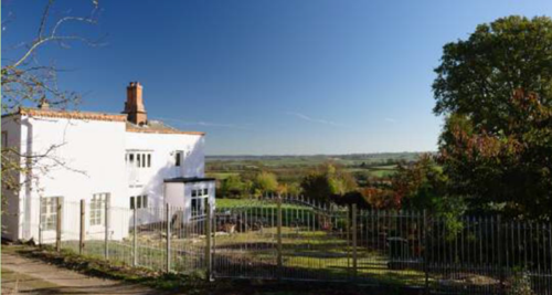
View 2
From the north of Church Lane towards the north-east. This view can be seen from Church Lane, an unadopted road to the
northwest of the village. This panoramic view affords extensive and uninterrupted views south and east from Nether Broughton to the south, as far as Belvoir Castle at the tip of the eastern ridge of the Vale of Belvoir. The view covers the route of the old Drovers Way across the south western part of the Vale of Belvoir. It is important because the panoramic view is a life enhancing part of the street-scene of the village, thoroughly demonstrating the context of a village named “Upper” that sits above valley below.
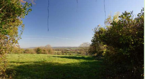
View 3
Views of the village from the A606 from the south. This view can be seen from the A606 to the south of the village as it enters into the built-up area. It shows the green rural streetscape which confines the conservation village. The view is important as it shows the extent of ribbon development down the A606 and indicates how the conservation village is defined by the rural setting.
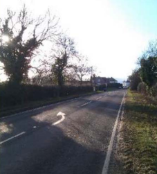
View 4
Views of Top Green from the A606. This view can be seen from the A606 as it leaves the north of the village. It shows the view looking
south towards Top/Daffodil Green the start of the built-up area in Top green heading west. The view is important as it shows the rural
context of the village to the west of the A606, setting off the beauty of the Green as a key feature of the village.
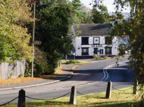
View 5
From Bottom Green, opposite the Old Saddlery, looking south. These views can be seen from Station Road. The view south from
Bottom Green across to Old Dalby and Dalby Woods is a panorama from south east to south west of arable land.
It shows the ridge above Old Dalby, and the valley between the two villages.
The view is important as it shows the view of the end of the Vale of Belvoir and the relationship between the village and the surrounding countryside. This view is one of several named, and unnamed, in this Plan which are seen from the roads through the
village and show the spaces between the buildings which individually and in aggregate deliver the substantial visual asset of linking the built-up area to the surrounding countryside These views are important because they differentiate the rural streetscape from an urban
environment. Only by maintaining these visual links to beyond the village can the essential rural feel of the architecture be conserved.
They demonstrate how the countryside and village sit side by side and reveal the agricultural heritage of the area.
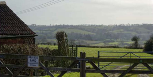
View 6
From Bottom Green, either side of The Barn, looking south. These views can be seen from Station Road. The view south from Bottom Green across to Old Dalby and Dalby Woods is a panorama from south east to south west of arable land.
It shows the ridge above Old Dalby, and the valley between the two villages.
The view is important as it shows the view of the end of the Vale of Belvoir and the relationship between the village and the surrounding countryside. This view is one of several named, and unnamed, in this Plan which are seen from the roads through the village and show the spaces between the buildings which individually and in aggregate deliver the substantial visual asset of linking the built-up area to the surrounding countryside.
These views are important because they differentiate the rural streetscape from an urban environment. Only by maintaining these visual links to beyond the village can the essential rural feel of the architecture be conserved. They demonstrate how the countryside and village sit side by side and reveal the agricultural heritage of the area.
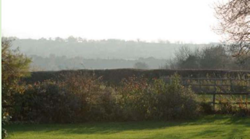
View 7
From Station Road, across the tennis courts, looking south. These views are taken from Station Road. They show the vista south
from the tennis club giving a wide panorama stretching from the south east to the south west of the village sets this important
recreational facility and community asset in a context linking the village within the surrounding countryside. The view is important as it shows the view of the end of the Vale of Belvoir and the relationship between the village and the surrounding countryside. This view is
one of several named, and unnamed, in this Plan which are seen from the roads through the village and show the spaces between the buildings which individually and in aggregate deliver the substantial visual asset of linking the built-up area to the surrounding countryside. These views are important because they differentiate the rural streetscape from an urban environment. Only by maintaining these visual links to beyond the village can the essential rural feel of the architecture be conserved. They demonstrate how the countryside and village sit side by side and reveal the agricultural heritage of the area.
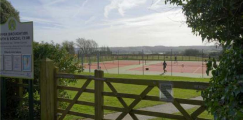
View 8
From western edge of the village looking south and north. This view is taken from Station Road at the western edge of the built-up
area. It shows the view south towards Old Dalby and west towards Six Hills. This view is seen from Station Road at the western edge of the built-up area of the village. The view is important as it shows how the countryside and village sit side by side and reveal the
agricultural heritage of the area.
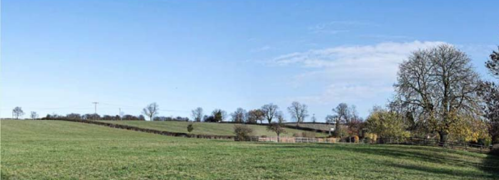
View 9
From Station Road looking south. These views can be seen from Station Road. The view south from Bottom Green across to Old Dalby
and Dalby Woods is a panorama from south east to south west of arable land. It shows the ridge above Old Dalby, and the valley
between the two villages. The view is important as it shows the view of the end of the Vale of Belvoir and the relationship between the village and the surrounding countryside. This view is one of several named, and unnamed, in this Plan which are seen from the roads through the village and show the spaces between the buildings which individually and in aggregate deliver the substantial visual asset
of linking the built up area to the surrounding countryside. These views are important because they differentiate the rural streetscape from an urban environment. Only by maintaining these visual links to beyond the village can the essential rural feel of the architecture be conserved. They demonstrate how the countryside and village sit side by side and reveal the agricultural heritage of the area.
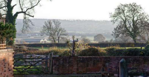
View 10
Upper Broughton from the south west. The view is taken from the public footpath along Longcliffe Hill and shows how Upper Broughton
nestles snugly into the rural and wooded hillside above and below the buildings. The view east into the Belvoir valley is maintained, linking the village into the surrounding countryside. The view is important as it shows the open and rolling countryside; the agricultural
heritage with pasture land, ancient hedgerows and trees that are typically across the Parish.
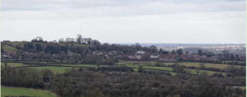
View 11
Upper Broughton from the southeast showing St Luke’s church. This view is taken on A606 at Nether Broughton, looking from the southeast towards Upper Broughton. The view shows how the village sits snugly beneath the Upper Broughton hill, framed above and
below by arable land and woodland. The view is important as it illustrates the open and diverse countryside, and the beautiful vistas enjoyed across the parish. It is particularly important as a view of St Luke’s church, defined in the Neighbourhood Plan as a local
landmark that contributes to the historic character and scenic quality of the area and a key landmark feature.
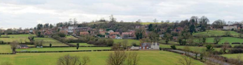
Appendix 4: Design Statement
Plan form and layout
1. Upper Broughton’s plan form is roughly T-shaped. In the west of the village a large variety of property types are found informally arranged on both sides of Station Road. In the centre of the village Station Road splits in two where it meets a village green. The two lanes, Bottom Green and Top Green, then head east to Melton Road (A606) which heads south downhill to Nether Broughton. The area
bordered by these three roads forms the central core of the village, which has a relatively high building density and includes the grounds and outbuildings of Broughton House, a substantial Georgian property. On the east side of Melton Road, the pattern of development is more dispersed with substantial buildings such as Yew Tree House and The Old Rectory standing in private grounds. The Church of St Luke, the former Baptist Chapel (now a private house), and the Golden Fleece Public House are also found on the eastern
side of the village. Chapman’s map (p.15) shows a street layout that has existed since long before 1774 and since 1900 the village has not expanded to any great extent. Apart from Sulney Close most of the infill development consists of scattered individual properties rather than small estates or streets. This has allowed Upper Broughton to retain its informal layout of loosely grouped buildings.
Gentrification
2. A new rectory was built by a wealthy Rector in 1855, designed by the same architect who updated Sandringham for Queen Victoria. Yew Tree House was extended several times in the 19th century around an early mediaeval structure which is believed to have been the village Manor House. On the arrival of the railway new residents with money from the city moved in and extended and enhanced several houses. The old farmhouse part of The Lodge is on the right side, dwarfed by the grand accommodation added on the left. Sulney
Fields (extended 1880 in an urban Georgian style) has or had an old farmhouse within it, as does Broughton House. The only ‘new’ house of that period appears to be Orchard Lea. A second wave of gentrification has taken place over the last 40 years, when redundant farm buildings have been converted to residences and detached infill housing has been built. Most of these houses have at least four bedrooms. Small houses of the 19th or earlier centuries have been reduced in number, either by being joined together as at Stone Cross
Cottage (formerly Barrack Yard) or by demolition. Five went to make way for the village hall and one for the bus shelter. Others went when the main road was widened in 1932. They were not replaced. After years of controversy, four council houses and six old people’s bungalows were built in 1974. These were intended to be for farm workers retiring from tied accommodation, some of which are now
privately owned following the introduction of ‘right to buy’ in the 1980s.
Recent development
3. Development in recent years has almost exclusively been large detached houses, comparatively over-developing their plot, of various pastiche designs. They have had little reference to the vernacular of the village but are typical of “up market” development seen across the country, thus bringing the danger of a sense of anonymity to the village.
Public realm
4. The village is defined by the presence of two village greens, and four other green spaces which the plan protects. This, together with a high proportion of houses set in large gardens, provides a sense of spaciousness. The intimacy of smaller properties and the spaciousness of the public spaces and larger houses combine to deliver a key component of the special character defining the village. The village contains a wide variety of different boundary treatments including walls, timber fencing, metal railings and hedges. Most of these contribute to the informal rural character of the village and often combine with grass verges to complement the properties behind. Boundary walls tend to be low brick structures with a stone or brick coping and hedges generally consist of a native mix of plants,
predominantly Hawthorn (the use of Leylandii hedging in places detracts from the character of the village). By contrast, some properties simply have open front gardens while others are positioned with their walls right up against the pavement or highway edge. Grass verges and mature hedgerows are a particularly strong feature on the approaches to the village where they line the road. In the village centre features such as the water pump on Rectory Drive and the stone cross on the village green add historic interest to the public realm.
Building types
5. The older buildings in Upper Broughton mainly consist of a mixture of farmhouses, cottages, Victorian and Georgian houses and outbuildings. There is a considerable variety in size, layout and design based on a common palette of materials. Equally important to the village’s special character are the random layout and the spaces between these properties.
Building materials and local details
6. There are buildings of stone, timber, cob and brick in the village, reflecting the prosperity of the village and the builder at various times. There is a lot of history contained in buildings which have not been listed. Traditional building materials were largely locally sourced. Bricks for example, were not transported far from where they were made, with most villages having their own brick pit and yard. The traditional building materials and details within the village are as follows:
7. Walls: 18th and 19th century buildings are almost always of red brick in a variety of bond patterns including random, Flemish and English garden wall. Brick walls on 18th century buildings usually have dentil corbelling at eaves level and often include embellishments such as ashlar windowsills and lintels and dentil corbelling at eaves level. Some examples of earlier stone walls and 17th century
timber framing (with brick or roughcast infill panels) exist. Several houses are finished in painted stucco or roughcast render.
8. Stone: Dressed ironstone blocks, probably quarried locally at Wartnaby, are only found in the manorial buildings and the church, probably dating from 1190 onwards. Ironstone rubble together with quartzite boulders washed out of the boulder clay were used as footings for timber-framed and cob buildings. Several cases are known where the stone was left in place when the timber or cob was
replaced with brick. A grey micritic limestone, originating as a thin layer in the village brick pits, was used for outbuildings and barns, but not houses, as it is not very frost-resistant, but was a cheap by-product. Where it is seen in houses, such as Greystone Cottage, the buildings can be shown to have originated as farm buildings.
9. Timber: No cruck-framed buildings which pre-date 1450 survive intact, but traces of frames, now replaced, can be found. Box-framed buildings of a later date have survived, notably Willow Cottage and Tudor Cottage (formerly Pond Farm). Sunny Cottage and Yew Tree House are known to contain ancient timber frames, and there are likely to be more to be discovered. Both are likely to have
originated as hall houses on the evidence of the position of their main chimneys and blocked entrances. Surviving partially cob buildings are in the rear part of the butcher’s shop and a rear wall in Church View, but other examples have been removed in recent years.
10. Brick: The brick yards in Hickling Lane seem to have started circa 1700 and finished about 1904, probably due to competition from industrially-made bricks brought on the railway (typically 27/8 inches thick). Some timber or cob houses had their walls replaced
with brick in a piecemeal fashion, e.g. The Golden Fleece where there are interior walls are of the earliest bricks (21/4 inches thick) but the outer walls are 19th century (25/8 inches thick). Some houses retain beamed ceilings supporting rush and plaster floors above which may be older than the walls now supporting them. Several farmhouses were built or rebuilt of brick in the 18th century. It is hard to find modern bricks which match the village bricks, but those used in building Vale View are a good approximation.
11. Roofs: Dominated by a mixture of Welsh slate and locally made orange/red clay pantiles. Eaves projecting perhaps one foot beyond the wall are often supported by corbelling – usually dentil but saw-tooth in the mid-19th century. This gives emphasis to the roof line. Some later eaves are narrower, and do not improve the look of the building. Gable ends are most commonly plain close verge where the tiles run to the edge of the brick gables, but a few examples of parapet gables exist, where thatch has been replaced. Brick chimneys are found on most properties in the either as ridge stacks or gable stacks with clay chimney pots.
12. Windows: Most Georgian and Victorian properties have timber horizontal sliding sashes, with many creating a symmetrical façade and having glazing bars. Cottages and historic agricultural buildings in the vernacular style typically have timber casement windows or horizontal sliding sashes.
13. Doors: Georgian and Victorian properties have panelled doors often combined with decorative fanlights, canopies or doorcases. Lower status buildings typically have timber plank and batten doors.
Design Guidance
Location and setting
14. The visual impact of Upper Broughton is more than the sum of its parts. It is a pleasing combination of many factors that delivers the context against which all development should be assessed. Some factors which define the environment are: the siting of the village snuggling below the top of the hill provides a pleasing aspect when viewed from distance; the range of styles, designs, sizes and
situations of the houses that gives interest and variety to the built environment; the visual links into the surrounding countryside provided by gaps between the buildings seats the village into the semi-rural setting.
15. Development which reduces visual links between the built-up part of the village and the surrounding countryside should be resisted. Developments which by virtue of scale or design disrespect the architectural relationship between buildings should be resisted.
16. The vernacular of 1700 –1850 is simple but elegant and is a good basis for the design principles of future developments. It is the most abundant style of pre-modern house in the village. It should be noted that all dwellings of this period, except basic cottages, tended to have main rooms which are about 14’ square, which is a very practical size for a room. Several houses were built end on to the road, which is another very practical East Midlands feature. These houses are very plain, but with well-proportioned doors and windows and corbelling. Together with the delightful tone of the red bricks they give rise to a streetscape which is very pleasing.
17. Understanding context is vitally important for all good design solutions. Recognising the roofscape, streetscape and landscape setting and reflecting the built form, proportions, features and materials of the original or surrounding buildings is important. This does not limit design proposals to mimicking existing buildings, and pastiche is to be discouraged. It is possible for modern designs and the use of modern materials to complement and enhance the existing environment. This will continue the spirit of evolution created by the different styles of houses that have been built over the years.
18. With every application the quality of design will be assessed with the rigour applied by Rushcliffe Borough Council’s conservation officer in a recent application. The following are examples of his comments : “The proposed squat mock Georgian replacement dwellings are generic in form and appearance and not rooted in a scholarly understanding of the rules of proportion which underpin this style of architecture….the proportions of window openings (too short for their width as drawn) all eschew the rules of proportion which apply to them….the design of the attached garage element with a prominent and steep roof slope is then completely contrary to the parapet approach on the main part of the building. Given the harm arising from the complete loss of a non-designated heritage asset, compounded by the weaknesses in the proposed designs of the replacements I cannot support this application.” This approach emphasises the importance of the design and setting for every application to ensure the environment of the village is not compromised.
19. As part of recognising the local distinctive characters, any new infill development should respect the existing pattern and density of
surrounding development. In particular, garden areas are recognised as making an important contribution to the character and appearance of an area, providing visual amenity benefits for local residents, contributing to both the spatial character and to the green infrastructure of the neighbourhood. Any proposal to develop on garden areas will be resisted and assessed against the impact the development will have on these characteristics and the impact on both the site itself and the wider locality.
Buildings and design
20. Development should reflect the scale, dominant building/house type and spaces between buildings in the adjoining streetscape. This will include will echo the scale of many of the dwellings existing in the village.
21. Extensions, including garages, should not dominate the original building and should be set back from the original frontage. Closure of the spaces between houses will not generally be acceptable, and all extensions should be designed to minimise the risk of overshadowing, visual dominance and overlooking of neighbouring areas.
22. Privacy is another issue to consider in order to prevent overlooking of adjoining houses.
23. Building design that minimises the environmental impact through the construction and on-going use of the house will be supported.
Building materials
24. Generally, materials should be chosen from the palette of materials described above. Again, the imaginative and sensitive use of modern materials will be encouraged when used together with high quality building design.
Roofs
25. There should be no dormers on main/ principle frontages i.e. facing streets or public spaces.
Doors, Windows & Porches
26. The proportions and patterns of doors and windows are critical features. Any alteration or extension should strive to reflect the style of the original building or its neighbours in this respect e.g. door architraves, window styles (casement, sash, mullioned etc.) and frames (sills and lintels). Those of new build proposals should either reflect neighbouring properties or be justified as part of the
overall design proposal.
Other Features
27. Infill development should incorporate traditional local treatments of boundaries such as walls, fences, grass verges, hedges, and other planting, as appropriate to the size and type of building being built. In some cases, this may reflect an existing ‘open plan’ layout. Existing boundary should be retained.
28. All new developments should provide for off street parking. Extension proposals that lose off street parking will be resisted.
29. Front gardens should be retained wherever possible and hard standing should be made of permeable materials, to prevent excessive water run-off.