Aslockton Conservation Area
Aslockton Conservation Area Appraisal and Management Plan August 2023

Contents
1.1 Conservation Areas
1.2 The Purpose of a Conservation Area Character Appraisal
1.3 The Planning Policy Context
2 Aslockton Location and Landscape Setting
3 Historical Contexts and their Perceptibility
3.1 Location and Historic Activities
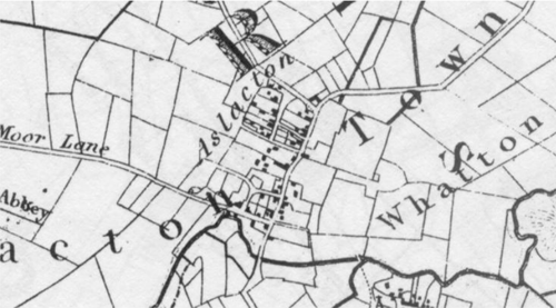
3.2 Historical Mapping
4.1 Plan, Form and Layout
4.2 Landmarks, Focal Points and Views
4.3 Open Spaces, Trees and Landscape
4.4 Public Realm
5 Buildings of the Conservation Area and Key Characteristics
5.1 Building Types and Activity
5.2 Key Characteristics and Building Materials
5.2.1 Key Characteristics: Entrance vial Mill Lane (Character Zone 1)
5.2.2 Key Characteristics: Narrow Lanes (Character Zone 2)
5.2.3 Key Characteristics: Southern Main Street (Character Zone 3)
5.2.4 Key Characteristics: Northern Main Street (Character Zone 4)
5.2.5 Key Characteristics: Chapel Lane (Character Zone 5)
5.3 Listed Buildings
5.4 Key Unlisted Buildings
6.1 Introduction
6.2 National and Local Policies and Guidance
6.3 Article 4 Directions
6.4 Building Design
6.5 Publicity and Knowledge Transfer
6.6 Public Realm
6.7 Boundary Treatments
6.7.1 Walls and Fences
6.7.2 Hedges
6.8 Buildings at risk
6.9 Enforcement
7 Appendix 1 – Listed Buildings
8 Appendix 2 – Conservation Area Boundary and Townscape Appraisal Map
1 Introduction
1.1 Conservation Areas
Rushcliffe Borough Council has an obligation under Section 69 of the Planning (Listed Buildings and Conservation Areas) Act 1990 to review, from time to time, its Conservation Area designations.
A Conservation Area, as defined under Section 69, is ‘an area of special architectural or historic interest the character or appearance of which it is desirable to preserve or enhance’.
Aslockton Conservation Area was designated in 2007. The Aslockton Conservation Area was reviewed in 2018 however; due to the pandemic the there were delays in the consultation. The appraisal document was updated to reflect the area’s recent developments and was adopted after consultation in August 2023.
Section 71 of the Planning (Listed Buildings and Conservation Areas) Act 1990 highlights the local planning authority’s duty to formulate and publish proposals for the preservation and enhancement of the conservation areas. This document, therefore, aims to identify and
reaffirm (or redefine) the special architectural or historic interest of the area which warrants its designation.
Conservation Area Appraisals are not, and never have been, tools for to fossilise a place against change, instead, the processes of change which allow places to grow and evolve are recognised as being unavoidable, and it is also recognised that change can be a positive and desirable force. The designation instead allows greater scrutiny and control to manage change to positive effect and to ensure that any changes which require planning permission do not harm, and ideally serve to actively enhance, the existing character of the place.
Aslockton Conservation Area: Summary of Special Interest
A linear village with a strong rural character.
Many of the roads have an enclosed feel, particularly the dense Main Road with walls and properties abutting the road. The
approaches to the village are dominated by hedgerows.
Many of the smaller side streets in the village have their own unique character such as the narrow Dawns Lane.
An archaeologically important village with strong historical associations with Thomas Cranmer who was born in the village and became Archbishop of Canterbury.
Many positive buildings which reflect the pre 1900 style of vernacular architecture in the Borough.
1.2 The Purpose of a Conservation Area Character Appraisal
The purpose of a Conservation Area Character Appraisal is to:
- Identify and record the special interest of the Conservation Area to ensure there is public awareness and understanding of what is
worthy of preservation. - To define and reassess current boundaries to accurately reflect what is now perceived to be of special interest.
- To identify opportunities to safeguard and enhance the special interest of the Conservation Area.
It should be noted that the content in this document is not a comprehensive account of every significant building, structure, tree, wall, feature, or space. Therefore, any omission should not be assumed to imply that they are of no interest.
Generally, the character and appearance of a Conservation Area will be preserved or enhanced by:
- Providing controls and regulating development through the planning system.
- Applying the extra controls that designation provides over demolition, minor development, and the protection of trees.
- Environmental enhancement schemes and possibly providing financial assistance for the repair and restoration of specific buildings.
- Encouraging public bodies such as the local highways authority or utility companies to take opportunities to improve the street scene through the appropriate design and sensitive sighting of street furniture (and retention of historic features of interest), or the removal of eyesores and street features that have a negative impact such as overhead wires.
1.3 The Planning Policy Context
This appraisal provides a firm basis on which applications for development within the Aslockton Conservation Area would be
assessed. It should be read alongside the wider development plan policy framework produced by Rushcliffe Borough Council and other
National Planning Policy Guidance documents. The relevant documents include:
- Rushcliffe Local Plan Part 1: Core Strategy, with a specific focus on:
- Policy 10 (Design and Enhancing Local Identity) [in part]
- Policy 11 (Historic Environment)
- Rushcliffe Local Plan Part 2: Development Policies, with a specific focus on:
- Policy 28 (Conserving and Enhancing Heritage Assets)
- Policy 29 (Development Affecting Archaeological Sites)
- The National Planning Policy Framework (NPPF) (Revised -2021)
- The National Planning Practice Guidance (2015 - Subject to Continual Review)
- By Design: Urban Design in the Planning System – Towards Better Practice (2000)
- The Planning (Listed Buildings and Conservation Areas) Act 1990
2 Aslockton Location and Landscape Setting
Rushcliffe Borough forms the southern tip of Nottinghamshire, which borders Leicestershire. It is predominantly a rural Borough that contains a mixture of city suburbs, market towns and villages. Rushcliffe is located about half a mile South of Nottingham city centre, with the River Trent forming the majority of its northern boundary and the River Soar defining its western boundary.
The A46 (Fosse Way), a distinctive Roman Road, runs through the centre of the Borough and leads to Newark in the North and Leicester in the South. In the northern half of the Borough, the A52 forms Nottingham’s primary transport link to Grantham and the East of England. Junction 24 of the M1 and East Midlands Airport are located about 1 mile from the western border.
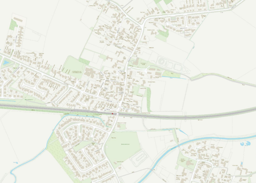
Aslockton is located to the North of the A52 due East of Nottingham and lies along the rail line from Nottingham to Grantham. The village is separated from Whatton by a watercourse which was a previous line of the River Smite. The village contains a primary school, a church, a post office/shop and a public house along with several other small businesses.

2.1 The Aslockton Conservation Area
The conservation area predominantly covers the parts of the village occupied before 1900. Since then, the village has increased through ribbon development along the main roads out of the village. The Conservation Area does not include the site identified as Cranmer’s Mound which was the site of a Motte and Bailey Castle with moated fishponds. This area is a Scheduled Ancient Monument and as such already receives statutory protection to a far greater degree. The boundary of the Conservation Area does not set out to try and include all open space around the village but where appropriate it does include open space within a logical boundary. For instance, the western
boundary follows for much of its length the western edge of the public footpath, to include a viewpoint over undeveloped land to the west and towards the former Maltings.
The setting of the conservation area contributes greatly to it by providing a strong connection to the village's rural origins. Most development in Aslockton has been low level ribbon development along the approach roads, thus the conservation area is mostly bordered by open fields, not urban development.
The village only has 2 listed buildings but the main body of the village contains a large number of high quality traditional buildings which make a positive contribution to the special character of the village.
At the time of the 2017 review of the conservation area appraisal a re-survey of the boundary was undertaken to determine whether the adopted boundary was still considered appropriate or whether any amendments were desirable.
On this occasion one property, Whiteways on Cliffhill Lane, has been identified which was previously just outside of the conservation area boundary but which makes a strong positive contribution to the character of the area such as to warrant its inclusion inside the boundary. This positive contribution had been previously acknowledged within the townscape appraisal.
The viewpoint immediately south of the railway crossing identified in the Townscape Appraisal also warrants inclusion.
There were no areas around the periphery of the conservation area which, as a result of changes or alterations, are no longer appropriate for inclusion and as such there are no reductions in the existing boundary proposed.
As a result of this re-assessment it is considered appropriate for the appraisal to be re-adopted with minor boundary changes to extend the conservation area and include within its boundary:
- Whiteways
- The viewpoint immediately south of the railway crossing
- Conservation Area Boundary covers: 14.5 hectares (approximate)
- Number of Grade I listed buildings: 0
- Number of Grade II* listed buildings: 0
- Number of Grade II listed buildings: 2
A full list of Aslockton Conservation Area’s Listed buildings can be found in Appendix 1.
3 Historical Contexts
3.1 Location and Historic Activities
Aslockton is first recorded in Domesday Book and would have been an agricultural community; this was the case even after the train station was built in 1850. The 1881 census shows that 45% of the population were farmers or agricultural labourers. The village would have been originally farmed on an open field system with a small number of large open fields surrounding the village. There is remaining evidence of this early agriculture in the form of ridge and furrow paddocks located to the north west of Cliffhill Lane. In Aslockton and Scarrington an Enclosure Act was made between 1779 and 1780 with the actual enclosure taking place in 1781. This resulted in the formation of many of the field boundaries we see today. Even where fields have been subsequently enlarged or combined
to accommodate larger agricultural machinery they often have at least one boundary which reflects the field pattern created in 1781, which itself would have retained at least some sections of boundary relating to the open fields, usually identifiable as having curving boundaries, such as some of the fields to the north side of Abbey Lane.
The village was a chapelry within the parish of Whatton until 1891. Within large and sparsely populated parishes it was common to find settlements with a ‘chapel of ease’ created so that the residents did not have to walk considerable distances to the Parish Church on Sundays, in this case the distance to the church at Whatton was not large via the ford but anyone wishing to arrive at church dry would have had to walk a considerable distance to the nearest bridge. In most cases a Chapel of Ease is still administered by the parish, but in this case the Aslockton Chapel was a ‘peculiar’ of Southwell Minster. In the 15th Century Nottinghamshire was within the Diocese of York
and all its parishes under the control of the Archbishop of York. The collegiate church at Southwell was a notable exception, being self-governing and independent of control from York. It was this collegiate church which established the chapel at Aslockton, as such it was not under the control of the Archbishop but the pre-bendal college at Southwell.
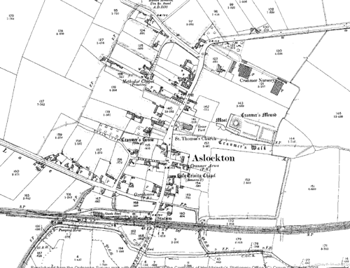
The present day parish church of St Thomas was built in 1891. The church cost £3000 and was paid for by Mrs Sophia Hall of Whatton Manor in memory of her son Thomas Kendrick Hall (former Vicar of Whatton who had died in a shipwreck). A Methodist Chapel was located on Chapel Lane the site of which has since been developed. The 15th Century Holy Trinity Chapel was located on Main Street, and the remains of it can still be seen incorporated into Cranmer’s Cottage.
Prior to 1891 church worship and burial between the villages of Aslockton and Whatton had always been joined, utilising the churchyard in Whatton. However residents of Aslockton were excluded from being buried in Whatton Churchyard in the 1860’s, this lead the village to buy a piece of land for use as a cemetery to the northwest of Aslockton. It is likely that the reasons related to overcrowding of the Whatton graveyard. Within 30 years Aslockton was granted status as a separate parish.
Aslockton has connections with Thomas Cranmer (1489-1556) who was born in the village and spent the first 14 years of his life here. He later became Archbishop of Canterbury, appointed by Henry VIII. He played a central role in the Reformation and was responsible for producing the 'Book of Common Prayer', for use in the Church of England and the Anglican Church worldwide. The original house belonging to the Cranmer family has disappeared (the site is now occupied by ‘Cranmer House’ to the North-West of the village centre). However a series of earthworks, behind St Thomas’s Church, known as Cranmer’s Mound, are thought to be the remains of sixteenth
Century gardens and watercourses, originally belonging to the family, and possibly occupying the site of a small Norman motte and bailey castle.
3.2 Archaeology
There is archaeological evidence of Iron Age and Roman occupation within Aslockton. The Key to English Place Names identifies the name Aslockton as having Norse Origins, and this is supported by recent academic research by the University of Nottingham. It has been suggested that the name is a hybrid name from the Old Norse male personal name Áslákr combined with the Old English element tun ‘farm, settlement’. The agricultural settlement has a low lying relatively flat surroundings being readily adapted to agriculture once cleared of woodland, with the nearby River Smite acting as a source of water rather than transportation (the river was crossable via a ford between Aslockton and Whatton).
Scheduled Monument - Cranmer’s Mound a Scheduled Ancient Monument located North of Saucer Farm to the East of Main Street. Grid Ref: SK 744 401.
In 1893 the grave of a warrior with sword and spear was discovered at Aslockton, the location of this is shown at the North of the 1900 plan above. Although the settlement of the village itself is thought to date back to the Saxon Period archaeological remains indicate sporadic occupation within the parish, as far back as the 5th century BC.
The settlement is not in a readily defendable landscape and would not have been founded in this location for any reason other than to exploit the surrounding good quality agricultural land.
3.3 Historical Mapping
4 Spatial Analysis
The relationship between open spaces and the built form within a conservation area can be central to its character. This section describes the village’s layout, highlighting the significant views, landmarks and historical focal points. The contribution of open green spaces, trees and other natural elements to the conservation area’s character is also described within this section.
4.1 Plan, Form and Layout
The village has maintained its linear form, with late 20th-century ribbon development extending along Abbey Lane (formerly Moor Lane), Mill Lane, and Cliffhill Lane. This layout offers occasional views into the surrounding fields and paddocks, reinforcing the village’s rural setting and historical roots.
The River Smite has historically acted as a natural boundary between the village and Whatton, a separation further emphasised by the later addition of the railway line. Despite some modest housing developments introducing parallel access roads, the overall road layout has remained largely unchanged since the 1784 enclosure map.
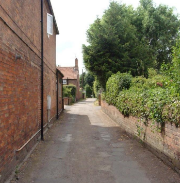
The streetscape of the village features several more intimate lanes and rights of way, often well enclosed by buildings, walls and hedging to create intimate a hierarchy of spaces within the public realm adding to the character and variety of the conservation area.
Below is a map that describes the current plan, form and layout of the village/town.
This map is reproduced from Ordnance Survey material with the permission of Ordnance Survey on behalf of the Controller of His Majesty’s Stationary Office © Crown Copyright. Unauthorised reproduction infringes Crown Copyright and may lead to prosecution or civil proceedings.
Rushcliffe Borough Council - 100019419
4.2 Landmarks, Focal Points and Views
The Townscape Appraisal map illustrates these key views along with the many other views and vistas that reveal the rural location of the village. The village doesn’t have many focal points, the enclosed nature of many of the streets focus views along the roads. Many of these enclosed lanes have a distinctly rural feel. As an example Abbey Lane from Main Road starts as a tightly enclosed lane with a high proportion of enclosure hedges and trees suggesting an imminent departure from the village into the countryside. This character changes after a few hundred yards as modern development takes over, showing the transition between the pre-1900 village and its modern expansion.
4.3 Open Spaces, Trees and Landscape
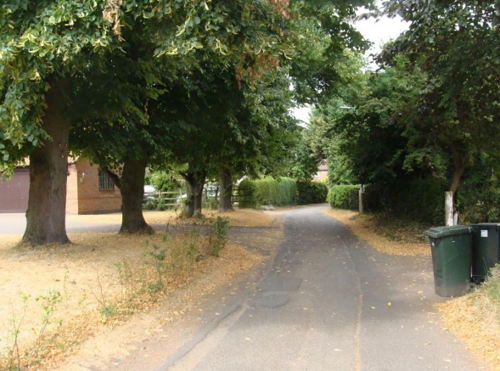
Areas within the conservation area are strongly influenced by trees and hedge planting which enclose the public realm and create a less formal rural character such as in Figure 5, Chapel Lane.
Elsewhere, such as in the eastern section of Abbey Lane mature trees and hedging enclose the public realm and give the lane a more enclosed and intimate character than in its more open western section.
The most significant trees, hedges, open spaces, grass verges and gardens are marked on the Townscape Appraisal map. There is no significant public open space within the Conservation Area, but there are areas to the South of the village. Whilst parts of the village have an enclosed feel there is still sufficient space in gardens for trees to make an important contribution to the character of the village and give it a mature setting.
Works to Trees
You must contact the Local Planning Authority (LPA), Rushcliffe Borough Council before any works (cutting OR pruning) are carried out to trees within the Aslockton Conservation Area.
Six weeks’ notice is required before any works to trees within the Conservation Area is carried out, even if they are not protected by a Tree Preservation Order (TPO).
If there is a tree which undergoes annual maintenance, include this information with the notice. It may be possible, upon agreement with the tree officer, that only one notice is required to cover the future annual maintenance.
Standard notification forms (a section 211 notice), further information and contact details.
A flow chart of the decision-making process regarding works to trees.
4.4 Public Realm
The village has a strong rural feel and this is predominantly characterised by Hawthorn hedges which help link the main body of the village along the rural approaches with the countryside beyond. Main Street has a mixture of boundary treatments dominated by brick walls and Hawthorn hedges. Significant walls and hedges are marked on the Townscape Appraisal map.
View looking North along Main Street with a typical mix of hedgerows and walls and one of the rural approached to the village dominated by hedgerows.
5 Buildings of the Conservation Area and Key Characteristics
5.1 Building Types and Activity
The building types in Aslockton reflect its origins as a small agricultural village and are surprisingly varied despite the settlement’s modest size. The most common forms are:
Vernacular Cottages
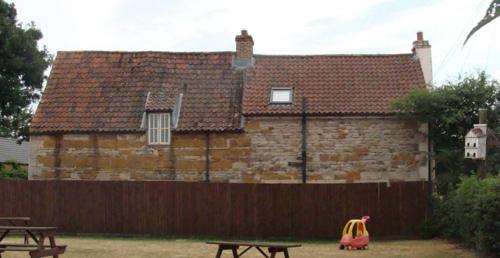
Typically one‑and‑a‑half or two‑storey, two‑ to three‑bay dwellings, originally housing farm workers and craftsmen. They are usually constructed of local red brick or coursed limestone, under plain tile or pantile roofs, with simple stone or brick dressings. A few retain timber‑framed casement windows, low doorways and gabled porches, contributing to the intimate street scene.
Traditional Farm Buildings
Scattered throughout the Conservation Area are small courtyarded complexes comprising former barns, stables, cart sheds and granaries. These outbuildings, often grouped around a yard, were originally laid in Flemish‑bond brick with large segmental‑arched openings, many have now been sympathetically converted to residential or home‑office use.
Victorian and Edwardian Infill
From the late 19th and early 20th centuries come a handful of larger houses set back behind front gardens. Built of stretcher‑bond brick with decorative bargeboards, timber sash windows and slate or tile roofs, these properties introduce modest ornamentation while respecting the village’s prevailing scale.
5.2 Key Characteristics and Building Materials
Prior to the arrival of the railway in 1850, building materials were largely locally sourced. Bricks did not often travel far from where they were made, leading to interesting village specific sizes, colours and styles. After 1784 the total volume of a brick was standardised (as the result of the introduction of a ‘brick tax’ levied as 4s per 1000 bricks –the tax was being undermined by brickmakers who simply started making larger bricks, forcing the government to legislate a maximum size for bricks) as such after the late 18th century local
variations in brick sizes cease.
Many buildings were also timber framed. Roofs would have been made from local materials such as thatch, stone and clay. This leads to a local vernacular architecture with a range of styles and materials.
The traditional building materials within the Conservation Area are as follows:
Walls: Reddy brown bricks dominate, although a number of properties have been rendered or painted cream.
Roofs: Predominantly clay pantiles and with some Welsh slate with plain closed eaves.
Windows: Timber sliding sashes, with many creating a symmetrical façade and having glazing bars, often set below a shallow brick arch. First floor windows are set just below the eaves.
Many windows not topped by arches have chamfered reveals, cills and hood lintels.
Doors: Traditional doors remain Timber.
Chimneys: The majority are located within the gable wall.
Although a wealth of vernacular cottages and farmhouses form the bulk of the buildings within the conservation area there are also a number of more formally designed buildings.
The parish Church is the most notable of these, built during the high Victorian Period in the scholarly Gothic Revival style. The Thomas Cranmer centre, begun 2008, represents a successful modern addition to the church and an example of how careful modern design can respect historic character.
5.2.1 Key Characteristics: Entrance via Mill Lane (Character Zone 1)
Key Characteristics / Architectural Features:
The village is approached through a distinctly rural landscape, where narrow lanes are flanked by traditional Hawthorn hedgerows. These natural boundaries define the edges of the road and contribute to the countryside character of the setting.
This arrangement provides a soft transition between the open fields and the built environment, reinforcing the village’s rural identity and sense of openness.
5.2.2 Key Characteristics: Narrow lanes (Character Zone 2)
Key Characteristics / Architectural Features:
This character area is defined by narrow lanes closely bordered by residential properties, creating an immediate sense of enclosure and intimacy. The lanes are lined with a mix of boundary treatments, including traditional Hawthorn hedges, brick walls, and timber fences, which contribute to the area's varied yet cohesive rural character.
Gardens, combined with the boundary treatments, form a layered edge between the public realm and private space, enhancing both privacy and visual interest.
5.2.3 Key Characteristics: Southern Main Street (Character Zone 3)
Key Characteristics / Architectural Features:
The southern half of Main Street forms a distinct character area, defined by its more enclosed and urban feel compared to the village’s generally rural character. Here, properties typically sit directly against the back edge of the pavement or road, with little or no front garden space. This close relationship between buildings and the street creates a strong sense of enclosure and a more continuous built frontage.
5.2.4 Key Characteristics: Northern Main Street (Character Zone 4)
Key Characteristics / Architectural Features:
The northern half of Main Street marks a subtle transition from the enclosed, urban character of the southern half to a more rural village feel. While a number of properties still front directly onto the road—maintaining a degree of enclosure—the overall impression is more open and informal.
Where buildings are set back from the street, the spaces are typically defined by brick boundary walls, which provide a sense of continuity and structure without fully enclosing the public realm.
These boundary treatments are often softened by vegetation, with hedges, or small garden plots adding greenery and contributing to the area's rural charm.
5.2.5 Key Characteristics: Chapel Lane (Character Zone 5)
Key Characteristics / Architectural Features:
Chapel Lane has a distinctly rural character, reinforced by its verdant setting and informal layout. The approach is marked by a strong sense of arrival, defined by mature trees and significant hedgerows that frame the entrance and establish the lane’s green, enclosed quality from the outset.
5.3 Listed Buildings
Buildings on the Government’s List of Buildings of Special Architectural or Historic Interest are called “Listed” buildings and are protected by law. Consent is required from Rushcliffe Borough Council before any works of alteration, extension, or demolition can be carried out on any listed building.
Further information can be found in Rushcliffe Borough Council’s publication Listed Buildings in Rushcliffe.
The complete list of the Secretary of State’s Statutory List of Buildings of Special Architectural Interest or Historic Interest can be accessed online.
5.4 Key Unlisted Buildings
Contribution to the established character of the place can also come from buildings which are not recognised via listing or are not old. A plan with all of the positive contributions to the area can be found in Appendix 2 - Conservation Area Boundary and Townscape Appraisal Map Almost 50 unlisted cottages, farmhouses and outbuildings have been identified on the Townscape Appraisal map as having a positive impact on the character of the Conservation Area. The majority of these 18th and 19th Century buildings have a strong relationship with Main Street and other side roads, with many gable walls facing onto the street. This creates a strong sense of place and, in a number of instances, of enclosure.
Before the creation of a separate parish of Aslockton the village had a chapel of ease. The unusual stone wall of the unlisted Cranmer’s Cottage may represent remnants of that 15th century chapel.
A distinctive stone wall now part of Cranmer’s Cottage, could be the remains of the 15th century Holy Trinity Chapel.
Since the conservation area was designated in 2008 the greatest change has been the construction of the Thomas Cranmer Centre attached to the north side of the Parish Church.
Outside the conservation area positive buildings such as the Aslockton Bake House and Mill on Mill Lane, Belmont House and Lilac Cottage on Cliffhill Lane, the Maltings on Abbey Lane and the Railway Villa on Vale Close, make strong contributions to the approaches and setting of the conservation area.
6 Generic Management Plan for Conservation Areas in Rushcliffe
6.1 Introduction
In carrying out its planning functions, the Borough Council is required in law to give special attention to the desirability of preserving or enhancing the character or appearance of Conservation Areas. The Management Plan for a Conservation Area is a tool to ensure the special character of the area is preserved and enhanced. The management plans aim to:
- Outline a strategic management proposal for the preservation and enhancement of the Aslockton Conservation Area.
- Act as a guide for professionals and residents alike regarding:
- features of value, worthy of preservation;
- characteristics worthy of preservation;
- opportunities for enhancement;
- development proposals which preserve and enhance the special character of the area.
- Inspire community commitment to conservation principles and reporting.
6.2 National and Local Policies and Guidance
There is a duty to formulate and publish management plans setting out policies and proposals for the preservation and enhancement of Conservation Areas. Many of these policies and proposals are common to all Conservation Areas, and these are set out in this document. The Central Government Guidance and Local policies applicable to Conservation Areas include:
- Rushcliffe Local Plan Part 1: Core Strategy, with a specific focus on:
- Design and Enhancing Local Identity [in part]
- Historic Environment
- Rushcliffe Local Plan Part 2: Development Policies, with a specific focus on:
- Conserving and Enhancing Heritage Assets
- Development Affecting Archaeological Sites
- The National Planning Policy Framework (NPPF), particularly, but not exclusively the chapter on Conserving and Enhancing the Historic Environment.
- The National Planning Practice Guidance (NPPG) (updated 2021 and subject to continual review)
- By Design: Urban Design in the Planning System – Towards Better Practice (2000)
- The Planning (Listed Buildings and Conservation Areas) Act 1990
- Historic England “Historic England Advice Note 1: Conservation Area Designation, Appraisal and Management”
The council will utilise the full range of strategic policy and guidance documents to ensure that development in Aslockton Conservation Area is of a standard that enhances the amenity of the local area. The council will always look to use the most up-to-date versions of the document.
Supplementary documents may be issued for individual Conservation Areas where specific policies or proposals are needed.
6.3 Article 4 Directions
There are extra consents required in Conservation Areas. For example, in addition to the general control of development, you will
need to get permission for
- Any additions or alterations to the roof (for example, dormer windows)
- The installation of satellite dishes on chimneys, roofs or walls fronting a highway
- Any extension which extends beyond the side of the original dwelling house
- Any extension of more than one storey that extends beyond the rear wall of the original dwelling house
- Cladding the exterior of the dwelling
- Any demolishing of a building or part of a building that has a volume over 115 cubic metres
Article 4 of the Town and Country Planning (General Permitted Development) Order 1995, allows planning authorities to restrict
some permitted development rights within particular areas. This does not necessarily prevent development or change taking place
but enables the Local Authority to manage the design and detailing of the works, and potentially grant permission subject to appropriate conditions. The use of Article 4 Directions will be proposed where it is considered appropriate following the completion of each Area Appraisal across the Borough.
Details of Article 4 Directions for Aslockton Conservation Area
There are currently no Article 4 Directions for Aslockton Conservation Area.
6.4 Building Design
Mimicking the local vernacular is not the only way to ‘fit in’ with the character of a conservation area. National policy makes clear that contemporary designed, provided it is sympathetically designed, cannot be dismissed as an option. Therefore, good contemporary design will be encouraged where it respects the context’s character, scale and massing. This must be demonstrated in the Design and Access Statement submitted with any planning application.
Extensions to buildings in Conservation Areas should respect:
- The key characteristics of the original building, including scale, mass, materials and proportions
- The contextual setting and character of the Conservation Area
Copying like for like can devalue and destroy the ability to “read” historic change, and dilutes our historic heritage. Pastiche designs, incorporating poor imitations of other styles, will be resisted, particularly where they incorporate details which are not locally appropriate. Careful high-quality replication may be required in a few very sensitive locations.
In particularly sensitive locations, such as uniform terraces, exact replication may be necessary to maintain compositional unity. In that case, attention to details, choice of materials and high-quality workmanship are the keynotes. However, in some cases, a direct relationship is not impossible. For example, Flemish Bond brickwork cannot be replicated in cavity walls, and narrow lime mortar joints cannot be replicated in modern metric brickwork.
Where a new building is appropriate, on infill sites or where an existing building detracts from the character of the area, the opportunity should be taken to re-establish the streetscape, reinforce enclosure, open up distant vistas or views of landmarks or hide unsightly views.
“New and old buildings can coexist happily without disguising one as the other, if the design of the new is a response to urban design objectives” (DETR – “By Design”, p19).
As with extensions, good contemporary design which respects local character, and the context of the site will be encouraged.
All new buildings should respond appropriately to the existing frontage and normally follow the established building line. Development or redevelopment will normally be resisted if:
“it blocks important views identified in the individual appraisals, uses important open spaces identified in the appraisals, adversely affects the setting of any Listed or key buildings, fails to maintain or re-establish the streetscape where appropriate dominates its Conservation Area background fails to recognise the context of
the site destroys important features identified in the individual appraisals such as boundary walls, fences,
hedgerows or trees”
Where the quantity of contemporary schemes in a small area becomes significant and outnumbers older buildings within the area, further contemporary schemes could fundamentally shift the architectural character of the area and thus be harmful, even if well designed as an individual project.
New development that stands out from the background of buildings may be appropriate in exceptional circumstances if it contributes positively as a landmark to enhance the street scene, to highlight a corner or to signal a visual change of direction such as along a curving vista.
Any external lighting should be carefully designed and sited to minimise light pollution. Energy producing or saving devices are generally welcomed by the Council, but careful consideration is required when these are to be located in a Conservation Area and some may require planning permission. In particular, they should be positioned to minimise their impact on the building and on the local amenity.
6.5 Publicity and Knowledge Transfer
Ambiguity about additional controls within a Conservation Area raises the likelihood of inappropriate developments occurring which
may damage the integrity of the conservation area designations.
Efforts have been made to engage local community groups in the development and review of the character appraisals. Empowering
communities to define the special architectural and historic interest of the Conservation Area aims to raise awareness.
Whether the appraisal took a community-led or a council-led approach, upon reviewing all Conservation Areas, the public were invited to ask questions and comment during a public consultation. A consultation event also aimed to diminish any ambiguity about
restrictions within a Conservation Area and increase the likelihood of sensitive and appropriate developments, maintaining the character
of the area.
The council recognise the potential issues of turnover in residency and ownership of properties in the conservation area. Therefore,
Rushcliffe Borough Council will periodically use their media outlets to highlight conservation area designations and the significant,
related planning controls.
The approach taken within Aslockton Conservation Area was Community Led.
The consultation period took place between the following dates - 23/01/2023 and 13/02/2023
The date of the Consultation Event was 04/02/2023.
If there are any queries about conservation areas, please email conservationareas@rushcliffe.gov.uk
6.6 Public Realm
General maintenance and upkeep to the public realm may include fixing damage to roads and pavements, and fixing issues with street lighting. Issues such as these can impact the quality of the Conservation Area.
The council aims to encourage works to the public realm that are in keeping with, or actively enhance the conservation area. Rushcliffe Borough Council can only advise on work within the public realm that does not require planning permission (for example work completed by statutory undertakers, such as the Highways Authority). In these instances, Rushcliffe borough council cannot prevent such work.
Nottinghamshire County Council are responsible for repairs to roads, pavements and street lighting. Report issues of repairs to roads, pavements and street lighting to Nottinghamshire County Council online.
Rushcliffe Borough Council will continue to undertake their duties in maintaining the public realm. Vandalism, fly tipping and street cleaning are all the responsibility of Rushcliffe Borough Council. Report issues to Rushcliffe Borough Council online.
You must contact the Local Planning Authority (LPA), Rushcliffe Borough Council, before any works (cutting OR pruning) are carried out to trees within the Aslockton Conservation Area
Six weeks’ notice is required before any works to trees within the Conservation Area is carried out, even if they are not protected by Tree Preservation Order (TPO).
Standard notification forms (a section 211 notice) - further information and contact details.
A flow chart of the decision-making process regarding works to trees.
6.7 Boundary Treatments
Where there is a proposal for a new boundary treatment to be installed, the council would encourage the use of boundary treatments within the area.
Within conservation areas, planning permission is required to alter, maintain, improve, take down or build any new gate, fence, wall or other enclosure with:
- A height of one metre or more if next to a highway (including a public footpath or bridleway), waterway or open space; or
- A height of two metres or more elsewhere.
Where planning permission is required to remove a wall, Rushcliffe Borough Council will aim to protect those boundary walls and fences that have been identified as positively contributing to the area.
Hedgerows are significant habitats for wildlife in lowland Britain. Regulations are intended to protect important hedges in the countryside. The policy applies to hedges that are more than 20m long, (or less if connected to another hedge) on or adjacent to:
- Land used for agriculture or forestry, including the keeping of horses or donkeys
- Registered common land and village greens
- Local Nature Reserves and Sites of Special Scientific Interest.
The policy does not apply if the hedge is within or on the boundary of the curtilage of a house.
6.8 Buildings at Risk
A few of the important buildings across the various Conservation Areas are currently vacant or not in regular use, which may lead to some being “at risk” of neglect or decay.
The Council will encourage and advise on renovation and repair work that is sensitive to the original or traditional historic character of the building and retains original features. The council will monitor the opportunity and potential for grant aid schemes to encourage the basic maintenance work necessary to ensure that key buildings within the conservation area are structurally sound and weather tight. However, given the current financial climate and outlook, such schemes are unlikely in the short to medium term.
There is a presumption against the demolition of buildings which contribute to the character of the area unless there are exceptional circumstances. It would benefit both the physical form and the function of the Conservation Area if these buildings were repaired, maintained and brought back into use.
Where the poor condition of a building or structure is as a result of neglect and lack of maintenance by its owner there is no requirement for the Borough Council to take its deteriorated condition into account when deciding whether demolition is appropriate. This is to avoid rewarding the deliberate neglect of buildings by representing such action as a way to obtain planning permission for demolition and redevelopment.
6.9 Enforcement
Rushcliffe Borough Council will, from time to time, assess and monitor changes in the appearance and condition of Aslockton Conservation Area. This will ensure that where necessary enforcement action can be taken promptly to deal with problems as they arise.
Where co-operation cannot be gained by any other means, Rushcliffe Borough Council has the ability to use additional enforcement powers to tackle particular issues within conservation areas. The Council may take formal action if the condition of any building (listed or unlisted) which makes a positive contribution to the character of the Conservation Area is considered to be at risk.
The council will work in accordance with their enforcement policy, which aims to provide an efficient enforcement service in support of the Council’s statutory planning service. Rushcliffe Borough Council’s enforcement actions will remain transparent, consistent, and proportionate, as it is recognised that effective controls over unauthorised development assists in conserving the natural and built environment whilst helping to protect the quality of people’s lives and maintaining the Council’s integrity.
7 Appendix 1 – Listed Buildings
Grade: II
Listing entry number: 1370146
National grid reference: SK 74245 40161
Location: Church Of St Thomas, Main Street
Shelter at Aslockton Railway Station
Grade: II
Listing entry number: 1245029
National grid reference: SK 74131 39910
Location: Shelter at Aslockton Railway Station, Main Street
*The titles of these listings may not make it clear that all listed buildings always include all attached structures and extensions, regardless of age, and all detached outbuildings built before 1 June 1948 which are, or were at the time of listing, ancillary to the function of the primary listed building and were in the same ownership at the time of listing.
For example, when a house is listed, the listing will apply to extensions, porches, detached historic stables, barns, wash houses, privies etc. Such outbuildings and extensions are only exempt from the provisions of listing where the listing specifically excludes them. Appendix 2 - Conservation Area Boundary and Townscape Appraisal Map.
8 Appendix 2 – Conservation Area Boundary and Townscape Appraisal Map

Conservation Areas
- Bingham Conservation Area
- East Bridgford Conservation Area
- East Leake Conservation Area
- Hawksworth Conservation Area
- Hickling Conservation Area
- Ruddington Conservation Area
- Thoroton Conservation Area
- Wiverton Conservation Area
- Langar Conservation Area
- West Leake Conservation Area
- Whatton in the Vale Conservation Area
- Costock Conservation Area
- Sutton Bonington Conservation Area
- Upper Saxondale Conservation Area
- Wysall Conservation Area
- Bradmore Conservation Area
- Car Colston Conservation Area
- Scarrington Conservation Area
- Orston Conservation Area
- Flintham Conservation Area
- Edwalton Conservation Area
- Aslockton Conservation Area
- Bunny Conservation Area
- Granby Conservation Area
- Keyworth Conservation Area
- Thrumpton Conservation Area
- Normanton on the Wolds Conservation Area
- Upper Broughton Conservation Area
- Kneeton Conservation Area
- Colston Bassett Conservation Area
- Cropwell Bishop Conservation Area