Tollerton Neighbourhood Plan 2025
Tollerton Neighbourhood Plan
Tollerton Parish Council
Plan period 2016-2030
Adopted February 2025.
Contents
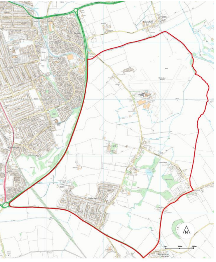
The designated neighbourhood plan area
What is neighbourhood planning?
Background and context
Vision and objectives
The spatial strategy for Tollerton
Policy overview and compliance with objectives
- Strategic policy
- Rural economy
- Community facilities
- Character and heritage
- Landscape and biodiversity
- Connectivity and transport
- Local housing and design
- Monitoring and review
- Maps
- Appendices
- Appendix A – Shop front design guidance
- Appendix B – Character summary
- Appendix C – Heritage assets list
- Appendix D –
- Appendix E – Local Green Space table
- Appendix F –
The designated neighbourhood plan area
What is neighbourhood planning?
1.1.1 Introduced by the 2011 Localism Act, neighbourhood planning aims to empower local communities to engage with the planning system to shape development in their area. This is done by the completion of a neighbourhood plan, a document recognised under the National Planning Policy Framework (NPPF). This neighbourhood plan must be in general conformity with the strategic policies of the Rushcliffe Local Plan Part One (2014) and Part Two (2019) and take into consideration relevant national policy and guidance.
1.1.2 The Development Plan comprises Rushcliffe Borough Council’s planning policies that set out the strategy for the development of houses, employment land, leisure uses and shops and services up until 2028. The Tollerton Neighbourhood Plan (TNP) will have a plan period up until 2030.
1.1.3 The Rushcliffe Local Plan Part One sets out the strategic planning policy for the whole Borough. This includes the allocation of sites for development. One of these allocated sites is within the Tollerton Neighbourhood Plan Area. This site is known as Land East of Gamston / North of Tollerton (the Sustainable Urban Extension). The Tollerton Neighbourhood Plan does not have the ability to remove or alter this site allocation. This Neighbourhood Plan therefore instead seeks to ensure that development that comes forward within Tollerton is of a high design standard and prioritises improvement of connections, enhancement of services and protection of landscape and green space.
1.1.4 The key topics that the TNP will focus on are:
- Sustainability
- The rural economy
- Community facilities
- Character and heritage
- Landscape and biodiversity
- Connectivity and transport
- Local housing and design
How will this neighbourhood plan benefit Tollerton?
1.1.5 The creation of the TNP will give local residents influence in the planning decisions affecting their local area in terms of the types of development to come forward, as well as setting high standards of design and sustainability. Neighbourhood planning will provide the residents of Tollerton with the opportunity to set out a framework for how development should take place in the village.
Who will use the neighbourhood plan?
The TNP seeks to assist a range of stakeholders, including the following:
- Landowners and homeowners proposing development (of a range of types and scales) within Tollerton
- Local residents and other stakeholders as they comment on planning applications submitted in Tollerton
- The Parish Council, who will remain a statutory consultee on all planning applications in Tollerton and who will monitor the neighbourhood plan once made and promote key community projects
- Rushcliffe Borough Council, who will be using the neighbourhood plan to determine planning applications in Tollerton.
Background and context
Geography / key features
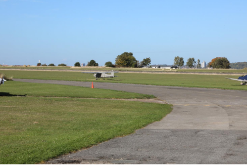
1.2.1 Tollerton lies within the Borough of Rushcliffe in the county of Nottinghamshire. The Parish lies approximately 4 miles south of the city of Nottingham, offering great accessibility to the city region. Tollerton grew in popularity thanks to the creation of Nottingham Airport (1930-present). It became more developed during the 1940’s. Tollerton Hall, located to the north of the village off Tollerton Lane, dates back to 1792. It has had several different uses since then including educational use as St Hugh’s College but is now a private residence.
1.2.2 The neighbourhood plan area follows the same boundary as Tollerton Parish. It comprises the historic core of Tollerton, along Tollerton Lane, dwellings on Cotgrave Lane, park homes at Tollerton Park and the largest area of housing, which centres on Burnside Grove and contains the majority of the area’s amenities. Nottingham City Airport is located within the north of the parish.
Census data
1.2.3 Tollerton falls within Rushcliffe, the population of which has increased by 7.1% from 111,100 since the last Census (2011) to 119,000 (2021), which is higher than the overall increase for England (6.6%). The population of Tollerton at the last Census (2011) was 1,883 with 944 males (50.1%) and 939 females (49.9%). Approximately 17% of the population was between the ages of 0 and 15, 56% between the ages of 16 and 64, and 27% aged 65 or older. The population of Tollerton’s built up area has increased since the last census (2011) from 1,544 to 1,634 in 2021 with 830 females (50.8%) and 804 males (49.2%).
Links to Rushcliffe Local Plan
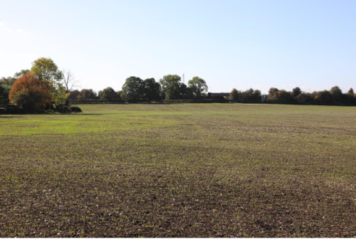
1.2.4 Tollerton is located within the Green Belt, with the exception of the strategic site East of Gamston / North of Tollerton allocated under Policy 25 of the Local Plan Part 1: Rushcliffe Core Strategy (referred to in this document as the Sustainable Urban Extension) to the north of the parish, which was removed from the Green Belt when the Local Plan Part One was adopted in 2014. This is the site of the existing Nottingham City Airport.
1.2.5 The Sustainable Urban Extension is an allocation for 4000 new houses and new employment space. This site was allocated by the Rushcliffe Local Plan and outline applications for development of parts of the site have been submitted but not yet decided. Policies within the TNP seek to influence the development of the site as it comes forward.
Preparation of the Tollerton Neighbourhood Plan
1.2.6 The and its policies have been shaped by input and feedback from the local community through a series of consultation processes in addition to work completed in Tollerton in 2016 to create the Tollerton Parish Community Plan. The vision and objectives within the Parish Plan have formed the basis of the vision and objectives for the TNP. The process began in spring of 2016. Firstly, the parish council established whether a neighbourhood plan was wanted by Tollerton residents. 97% of people who attended this consultation were in favour of creating one.
1.2.7 The second stage took place throughout the summer and autumn of 2016. This involved designating the area that the plan would encompass. An application was sent to Rushcliffe Borough Council for all of Tollerton parish to be included in the neighbourhood plan area. This application was approved.
Vision and objectives
Vision
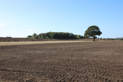
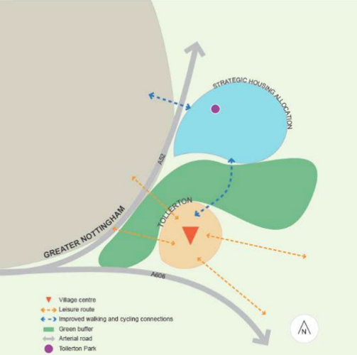
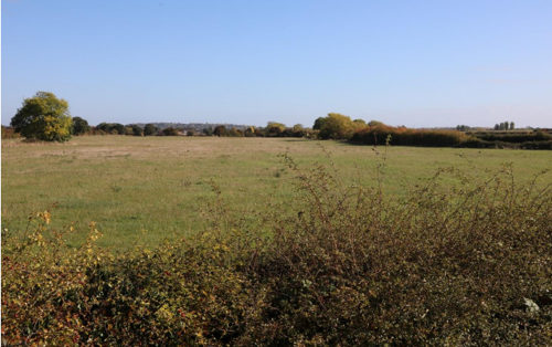
1.3.1 Tollerton is a vibrant community with a rich history and heritage surrounded by farmland with views of open countryside, hills and woodland. This Neighbourhood Plan seeks to protect this special character and safeguard it for existing and future residents. Key assets, valued by residents, are given protection whilst opportunities for sympathetic enhancement and development are identified and encouraged. The parish will need to evolve in response to climate change and the proposed Sustainable Urban Extension to the east of Gamston/north of Tollerton. This plan aims to make the most of these opportunities for the parish whilst conserving its rural setting.
Objectives
1.3.2 For the Vision to be implemented and effective, it must be broken down further into key objectives, all of which contribute to the delivery of the Vision. The draft objectives are presented below that address a specific issue identified from the questionnaire and consultation with key groups and organisations. To ensure that the vision can be implemented and is effective, it must be broken down further into objectives that contribute to the delivery of the vision. These objectives form the outline of the Neighbourhood Plan and are delivered through the policies.
- To celebrate and look after the tranquillity, landscape and heritage within our parish whilst keeping community at its heart.
- To create a village hub with shops, services and community spaces that the parish can be proud of.
- To ensure that the design and appearance of any new development make a positive contribution to local character and sense of place.
- To promote healthy and sustainable living habits by encouraging the use of ‘green’ modes of travel around the parish to reduce the parish’s emissions and reliance on the car.
- To protect existing areas of green space, including the green buffer to the north of the village, and ensure future development contributes to the creation of a strong network of green biodiverse spaces and corridors.
- To ensure road and transport improvements create streets and spaces that are safe, attractive and prioritise the most vulnerable road users first.
- To support existing businesses and encourage start-ups and independents that will contribute to the green economy and are sympathetic to the rural setting of the parish.
- To encourage the delivery of community facilities and services to meet the needs of the parish today and in the future.
- To encourage the self-contained Sustainable Urban Extension to come forward as a new and successful settlement that remains well connected with Tollerton through good infrastructure and community links.
The spatial strategy for Tollerton
1.4.1 The aim of the spatial strategy is to show the vision for Tollerton parish in a visual way. All the policies work towards this strategy. Whilst Tollerton village and the Sustainable Urban Extension to the east of Gamston/north of Tollerton are within the same parish, the aim is to ensure that both function as self-sufficient settlements meeting the needs of existing and future residents. Key to this vision is that the two settlements will be separate but well connected, particularly by foot and bicycle. The existing green buffer between the two settlements will be maintained and enhanced.
Policy overview and compliance with objectives
| Policy | Objective |
|---|---|
| Policy 1: Climate Change | Objective: 1, 4, 5, 6, 7 |
| Policy 2: The Village Centre | Objective: 1, 2, 4, 7, 8 |
| Policy 3: Supporting the Local Economy | Objective: 1, 2, 4, 7, 8 |
| Policy 4: Existing Community Facilities | Objective: 1, 2, 4, 7, 8 |
| Policy 5: New Community and Retail Facilities | Objective: 1, 4, 7, 8 |
| Policy 6: The Green Buffer | Objective: 1, 3, 4, 5, 9 |
| Policy 7: Local Character and Historic Environment | Objective: 1, 3, 5 |
| Policy 8: Landscape Character | Objective: 1, 5 |
| Policy 9: Local Green Spaces | Objective: 1, 5 |
| Policy 10: Biodiversity Enhancement | Objective: 1, 5 |
| Policy 11: Sustainable Modes of Transport and Movement | Objective: 1, 4, 6 |
| Policy 12: Tollerton Housing Strategy | Objective: 3, 4 |
| Policy 13: Design in New Development | Objective: 1, 3, 4, 6, 8 |
1. Strategic policy
Policy 1: Climate Change
All development proposals will be expected to contribute towards the mitigation of, and adaption to climate change, and to comply with national and local targets on reducing carbon emissions and energy use, unless it can be clearly demonstrated that full compliance with the policy is not viable or feasible. This is in accordance with Policy 2(1) of the adopted Local Plan Part 1: Rushcliffe Core Strategy. Applicants for planning permission will be expected to show that the detailed provisions of Core Strategy Policy 2 have been taken into account when submitting their proposals.
The Parish Council encourages applicants to demonstrate through a statement submitted with the planning application how proposals meet the following objectives:
- located nearby existing services and facilities to reduce the need to travel
- designed to encourage working from home to reduce the need to travel
- designed to encourage the use of sustainable modes of transport including walking, cycling and public transport
- designed to be accessible for everyone particularly those with reduced mobility including consideration of all ages including the very young, elderly and those with wheelchairs and prams
- designed to use all resources more efficiently during construction
- proposed building materials are sustainable, recyclable and locally sourced where possible
- designed to reduce carbon emissions and the use of water and energy for the lifetime of the development adopting green energy measures, where possible
- encourages the use of electric vehicles through the provision of electric vehicle charging points
- avoids demolition of existing structures but, if demolition is demonstrably necessary, reuses materials that exist on site where practicable
- takes a proactive approach to encourage biodiversity and wildlife
The Parish Council strongly encourages applicants to carefully consider the above factors in the design of proposals and to pursue development that is capable of climate adaptation and crucially encourages use of sustainable movement patterns. The sourcing of building materials locally contributes positively to new development in terms of reducing the distances materials have been transported and also helps reinforce local character by using facing, roofing and surfacing materials available locally. The Parish Council also wants applicants to carefully consider whether demolition of existing buildings can be avoided and if not, that materials can be reused on site.
Explanation
2.1.1 Tollerton as a community is committed to reducing the carbon footprint of the parish and working towards carbon neutrality. The Parish Council wants climate adaptation to be considered carefully by all those proposing development in the parish whether it is a residential extension or new dwellings or services.
2.1.2 The above measures will be encouraged alongside campaigns and programmes led by the community and Parish Council to raise awareness of how small actions can cumulatively make a significant impact on the fight against climate change.
2. Rural economy
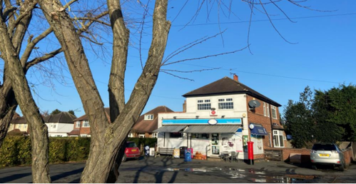
Policy 2: The Village Centre
The junction of Burnside Grove and Stansted Avenue has been identified as a Village Centre as shown in Map 1a. Within this area, uses, businesses and activities that support the growth of this as a village centre, including but not limited to, food, retail, community uses, social uses, and pop-up events and shops, will be considered appropriate subject to their impact on local amenity. The design of shop fronts should make a positive contribution to the area, following guidance in Appendix A, and ensuring that premises are accessible for all.
Planning applications that enhance the area to create spacesthat are better suited for public events and pop-ups by way of public realm and environmental improvements will be supported subject to amenity impacts.
Aspiration - Methodist Church
Tollerton Methodist Church is located in the centre of the village on Stanstead Avenue adjacent to the hugely successful community owned Air Hostess Pub. It is increasingly likely that the Methodist Church site will become vacant during the plan period of the Neighbourhood Plan. The Parish Council will seek to ensure that the site continues to benefit the community and will expect community consultation to be undertaken prior to submission of a planning application.
Explanation
2.2.1 This policy seeks to better establish a local centre of community activity within the village. Tollerton Parish Council is keen to encourage development that will further establish this area as a hub for events and activities run by and for the community. Using the success of the community owned Air Hostess as a catalyst, the aim is to guide further development in this area that would support the vitality of the village and create a central focus for activity. Working alongside Policy 6, this policy seeks to ensure that such new development is well-considered and fills the existing gaps that exist in the village. Facilities that have been requested by the community, such as a café, will be encouraged through this policy but directed towards the village centre.
Policy 3: Supporting Existing Businesses
Development t involving new business or the expansion of existing ones (including homeworking) will be supported in principle, subject to account being taken of other relevant policies of this Plan and Policies 1 and 15 of the Local Plan Part 2: Land and Planning Policies. In particular, proposals will be required to demonstrate that:
- There is adequate provision for parking and servicing
- There is no harmful impact in residential amenity
- There is no harmful impact on the visual qualities of the Parish
In addition:
- A travel plan and car parking strategy will be required to accompany planning applications for all major developments (as defined by the Development Management Procedure Order).
Explanation
2.2.2 Through this policy, the Parish Council seeks to protect and support the Local Economy of Tollerton, allowing existing businesses to not only survive but grow, and supporting people who wish to set up new businesses within the Parish. Homeworking is common across the parish and looks set to become more common. This policy additionally seeks to create a mechanism that supports those who wish to work from home.
2.2.3 The TNP recognises and values the contribution that local businesses make to the local economy and how important they are in providing employment and services to the community. It is crucial however that these businesses, and any new proposed premises, complement the existing character and setting of Tollerton. This policy therefore requires proposals to consider the other policies within the TNP and policies 1 and 15 of the Local Plan Part 2: Land and Planning Policies.
2.2.4 Finally, the Parish Council wishes to support development that encourages and supports residents who want to ‘work from home’ either at their house or in a shared premises. Proposals for shared workspaces that provide meeting rooms or desks within or near the village centre will be welcomed.
3. Community facilities
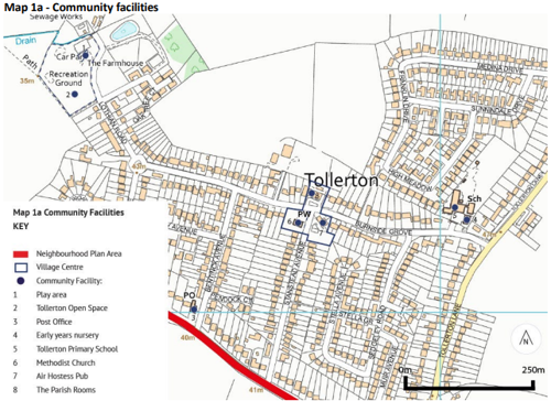
Policy 4: Existing Community Facilities
Development that would result in the loss of, or have a negative impact on, the existing community facilities listed in the explanation to this policy, and whose locations are shown on Maps 1a and 1b, will not be granted unless the criteria set out in Policy 30 of the Local Plan Part 2: Land and Planning Policies are met. Community-led schemes to provide or retain such facilities will be particularly encouraged.
Explanation
2.3.1 Tollerton has a strong base of independent and locally run community services and facilities. These all contribute significantly to Tollerton’s strong sense of community and place. This policy seeks to both support and future-proof these facilities to secure their long term local role. By recognising that demand may change over time, this policy aims to ensure that these sites are retained for use by the community and can adapt to the needs of those who live in the parish.
2.3.2 The identified existing facilities to be protected include:
Map 1a
- Play area, Lothian Road
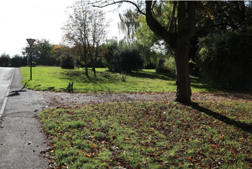
- Tollerton Open Space, Lothian Road
- Post Office, Melton Road
- Early years building, Burnside Grove
- Tollerton Primary School, Burnside Grove
- Methodist Church and Grounds, Stanstead Avenue
- Air Hostess Pub, Stanstead Avenue
- The Parish Rooms, Burnside Grove
Map 1b
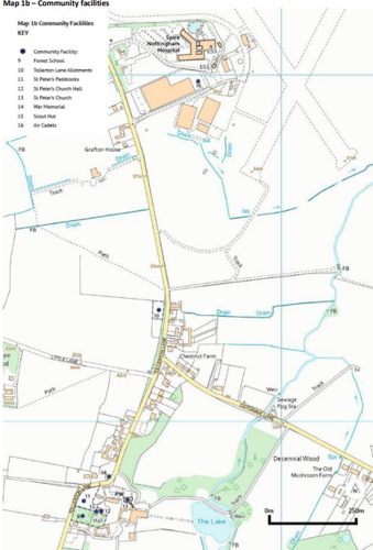
- Forest School, Tollerton Lane
- Tollerton Lane Allotments, Tollerton Lane
- Paddock, Tollerton Lane
- St Peter’s Church Hall, Tollerton Lane
- St Peter’s Church, Tollerton Lane
- War Memorial, Tollerton Lane
- Scout Hut, Tollerton Lane
- Air Cadets Headquarters building, Tollerton Lane
2.3.3 The criteria set out in Policy 30 of the Local Plan Part 2: Land and Planning Policies should be met. The criteria are listed below:
- alternative provision exists with sufficient capacity, which can be reasonably accessed by walking, cycling or public transport and would not result in a significant increase in car journeys;
- alternative provision will be provided as part of the redevelopment of the site;
- alternative provision will be provided in an appropriate location, which can be reasonably accessed by walking, cycling or public transport and would not result in a significant increase in car journeys; or
- it has been satisfactory demonstrated that it is no longer economically viable, feasible or practicable to retain the existing community use and its continued use has been fully explored.
Policy 5: New Community and Retail Facilities
Proposals for new or expanded shops, services and community facilities will be supported in principle, subject to compliance with other relevant policies of the Plan. Particular encouragement is given to proposals located within or adjacent to the village centre.
Aspiration - Welcoming new services to the village centre
The Parish Council welcomes new services and facilities in the village centre and in the historic core of the village. Consultation throughout the production of the TNP has found that residents are keen for there to be a greater cluster of services, particularly in the village centre. The following services would be considered to positively enhance the offer of the parish for residents and visitors:
- Cafés
- Social meeting spaces for all age groups
- Grocers / local produce store
- Pop-up uses and events
- Outdoor play areas and spaces
- Sports and recreation
- Changing rooms at the Tollerton Open Space
- Public transport facilities
- Facilities for cyclists
Explanation
2.3.4 Tollerton currently has some provision of amenities. However, the parish lacks some key facilities that would improve people’s quality of life and limit the need to leave the village for certain everyday needs. This aspiration therefore seeks to support development that would encourage new facilities in the parish.
Policy 6: The Green Buffer
Proposals for development should not reduce or diminish the physical and visual separation established by the Green Buffer between the settlement of Tollerton and the sustainable urban extension Land East of Gamston/North of Tollerton (illustrated on Diagram 1). In making this assessment, consideration will be given to the individual effects of the proposal and the cumulative effects when considered with other existing and proposed development.
Explanation
2.3.5. The TNP seeks to retain the separation between Tollerton and the Sustainable Urban Extension Land East of Gamston/North of Tollerton through the establishment of a Green Buffer (illustrated on Diagram 1). Within the Green Buffer, the development of larger scale development and incremental, piecemeal smaller scale development which could result in the merging of Tollerton and the Sustainable Urban Extension will be resisted. It is important to the community that the separate identities of the two settlements are retained and coalescence avoided. This is reinforced by the existing topography that rises between the current airfield and Tollerton village.
2.3.6. There is also a further aim for this area to make a positive contribution to the biodiversity of the parish in addition to protecting natural water systems so that surface water can safely travel to nearby watercourses. Where possible, opportunities to enhance the quality and biodiversity of these areas should also be considered to improve water quality and amenity.
4. Character and heritage
Policy 7: Local Character and the Historic Environment
All new development will be expected to respect, and where practicable, enhance the physical attributes and historic assets and local built and cultural character of the Parish, in accordance with other relevant policies within the Plan and the relevant parts of Policy 1: Development Requirements and Policy 28: Conserving and Enhancing Heritage Assets of the Local Plan Part 2: Land and Planning
Policies. The designated and non-designated heritage assets located in the TNP area are identified in Appendix C.
Innovative and contemporary design will be supported where it is sensitive to this local character. Applicants will be expected to set out how their design proposals contribute positively to this local character through:
- plot sizes, building lines and density
- architectural style, use of materials and detailing
- boundary treatments and other landscape features
Schemes that seek to ensure that heritage assets remain in long-term active and viable use, and/or seek to bring existing heritage assets back into use, will be strongly supported. Applications that are sensitive to their heritage and cultural value will be encouraged.
Explanation
2.4.1 The Parish has a mixed but unique local built character. Appendix B contains a character summary of the basic elements of Tollerton’s characteristics, heritage and natural environment that the TNP aims to maintain and enhance. This policy seeks to ensure that all future development is designed to be in keeping with and reflective of this local built character.
2.4.2 Tollerton contains many heritage assets, both designated and non- designated, as identified in Appendix C, that are all central to defining the character of the parish. Proposals that seek to secure the long-term use or protection of a heritage asset will be supported where it can be demonstrated that the significance of the asset is retained, as per the requirements of the NPPF. In all proposals affecting heritage assets, their significance should be consciously considered at the concept stage of an application putting Tollerton’s heritage at the forefront of the process.
2.4.3 The Parish Council is keen to protect cultural features that cumulatively contribute to the unique character of Tollerton. Proposals are encouraged to consider how cultural features (including the non-physical) have been carefully taken into account. Integration of the cultural heritage of the parish into development proposals can be achieved through interpretation boards, signage, street and place names and public art.
Policy 8: Landscape Character
All new development will be expected to respect, and where practicable, enhance the key identified features that contribute to the landscape character of the parish in accordance with other policies within the Plan and the relevant parts of Policy 1 Development Requirements, Policy 34 Green Infrastructure and Open Space Assets and Policy 37 Trees and Woodlands of the Local Plan Part 2: Land and Planning Policies.
Appendix B lists several key features that contribute towards the landscape character of Tollerton. The list at Appendix B has been expanded upon, but is not limited to, the below:
- Areas of woodland
- Field boundaries
- Mature trees and hedgerows
- Landscape views and vistas
- Watercourses and waterbodies
- Grass verges
- Green spaces / paddocks
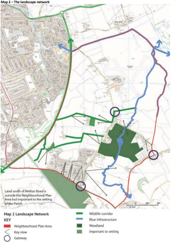
The following features are identified on Map 2 as they contribute towards the landscape character and identity of the Parish. Applications that result in the loss or harm to these features will be resisted:
- Key green and open spaces
- Views and vistas as listed at Appendix D
- Gateways into the settlements
Explanation
This policy seeks to define the key features that make up the local landscape character, which is so important to the setting of the parish. These features have been suggested by the community and tested through site work. The policy also seeks to protect and enhance these features including woodland, field patterns and important trees and will resist their loss.
5. Landscape and biodiversity
Policy 10: Landscape Character
Development proposals should seek to retain, and where possible enhance, key identified features that contribute to the landscape character of the parish.
These key features include but are not limited to:
- Areas of woodland
- Field boundaries
- Mature trees and hedgerows
- Landscape views and vistas
- Watercourses and waterbodies
- Grass verges
- Green spaces / paddocks
Specific features identified on Map 4 are considered to make particularly important contributions to the landscape setting of Tollerton and applications that result in loss or harm will be resisted. Many of these features also make important contributions to local water management and biodiversity.
Where development proposals will impact negatively or result in the loss of one of the above listed features, applications should be accompanied by hard and soft landscape plans that propose and set out appropriate mitigation or replacement. Where a key view is to be affected, an assessment on the impact of that view will be required to support the proposal.
The following features are identified on Map 4 as they contribute to the local character and identity:
- Key green and open spaces
- Views and vistas
- Gateways into the settlements
Explanation
2.5.1 This policy seeks to define the key features that make up the local landscape character, which is so important to the setting of the parish. These features have been suggested by the community and tested through site work. The policy also seeks to protect and enhance these features including woodland, field patterns and important trees and will resist their loss.
Policy 9: Local Green Spaces
The Neighbourhood Plan designates the following sites within Tollerton as Local Green Spaces in accordance with paragraph 105 of the NPPF, see Map 3 and Appendix E for a full assessment of each against the criteria:
- Tollerton Lane Allotment, opposite North End Cottage
- Brookers Bank, Tollerton Lane
- Huntsman Green, junction of Cotgrave Lane and Cotgrave Road
- St Peters Paddock, Tollerton Lane
- Tollerton Open Space and playing fields, Lothian Road
- Priory Circus
- Lenton Circus
- Methodist Church grounds, Stanstead Avenue
- Pinfold, junction of Tollerton Lane and Cotgrave Lane
- Wildflower verges, Burnside Grove
- Burnside Grove – grass verges
- Grantham Canal
Inappropriate development on these sites or their loss for community use will be strongly resisted. Development of flood resilience schemes within local green spaces will be supported provided the schemes do not adversely impact the primary function of the green space.
Explanation
Local Green Spaces are a land allocation set out within the NPPF intended to protect green areas of particular importance to a community from inappropriate development. The green space must meet certain criteria to qualify; it should be in close proximity to the community it serves, special and of local significance (beauty, history, recreational value, tranquillity or wildlife). The sites listed and mapped have been suggested by the community as of particular value locally. Appendix E sets out how each of the spaces listed meets the criteria of the NPPF. Some of these local green spaces are located within highways land and are considered to make a key contribution to local amenity and character.
Policy 10: Biodiversity Enhancement
Proposals that incorporate the protection and enhancement of the green and blue infrastructure network identified in Map 2 will be supported. The loss or fragmentation of the identified network will be resisted.
Planning applications, regardless of scale, should actively promote biodiversity enhancement to create new habitats or protect and enhance existing habitats. Proposed development that incorporates the creation of new spaces and planting specifically for wildlife will be supported. Proposals of all scales will be expected to deliver a minimum of 10% biodiversity net gain and the implementation of measures beyond this will be encouraged.
Explanation
2.5.3 The parish’s existing network of green infrastructure is shown in Map 2. This includes important wildlife corridors and identifies gaps within the network where improvements could be made. This policy requires new development to contribute positively to this network and not lead to its loss or fragmentation. Proposals that seek to enhance biodiversity and rewilding of sites in the village or allocated sites will be supported.
2.5.4 This policy also encourages local scale interventions that promote and enhance biodiversity within the parish through campaigns to encourage measures in people’s gardens and strategies for specific areas of land or facilities. Community support exists for biodiversity interventions such as a village pond and areas of wildlife and tree planting.
6. Connectivity and transport
Policy 11: Sustainable Modes of Transport and Movement
Where practicable, and as appropriate to its scale and character, development should seek to reduce reliance on the private car and encourage more sustainable and active types of transport. Whilst recognising the rural location of the parish, development that takes opportunities to make walking, cycling and horse-riding a practical and safe option should be encouraged.
Proposals that enhance existing routes through improved quality or connecting/creation of the network will be supported. The enhancement of the routes identified on Map 4 will be encouraged. The provision of electric vehicle infrastructure throughout the village, for example public charging points, will be encouraged and, for major schemes, considered mandatory.
Aspiration - Developer contributions
Developer contributions will be sought to support the enhanced running of bus services, including night time services, serving the village of Tollerton and the Sustainable Urban Extension to the east of Gamston / north of Tollerton from major developments. .
Explanation
2.6.1 This policy seeks to establish a safe network of walking and cycling routes across the parish. It will identify these important routes within the parish (including safe off road cycling to the Grantham Canal, neighbouring settlements and east-west bridleways and footpaths) and support their improvement. New developments in Tollerton should take existing and proposed links into consideration in seeking to improve connections. This includes the new foot-cycle bridge that is to be built by 2024 by Nottingham City Council between Lady Bay and Trent Basin (Poulton Drive) across the River Trent.
2.6.2 This policy is accompanied by an aspiration that seeks to support and safeguard the existing public transport routes that run through the parish connecting nearby villages and other services. This is linked to but beyond the role of the planning system however, developer contributions should focus on improving these connections.
Aspiration – The Tollerton Movement Strategy
The improvement of the parish’s streets is encouraged through works that prioritise more vulnerable road users. Development will be required to consider the needs of the most vulnerable road users first, using the following road user hierarchy:
- Pedestrians
- Cyclists and scooters
- Horse riders
- Public transport
- Goods traffic
- Motorbikes
- Long-distance freight and private car traffic
A strategy for the whole parish has been prepared that combines multiple transport modes, see Map 4. The Parish Council will also work to achieve these aims. This strategy includes ‘green lanes’ where cyclists and pedestrians have priority and may incorporate traffic calming measures.
The improvement of the key junctions and roads listed within Appendix F will be prioritised, subject to discussions with the local highway authority and Highways England.
Explanation
2.6.3 This aspiration identifies key junctions and highways that the TNP has identified as being in need of improvement associated with the strategic growth in the parish, subject to discussions with the local highway authority and Highways England. This includes specific reference to ‘green lanes’ where cyclists and pedestrians have priority, and may include traffic calming measures. In all cases non-road users will be a priority. This policy works in conjunction with policies on walking, cycling and public transport that seek to secure their safety and ensure they are kept as the priority. Overall, these policies seek to improve sustainable and active modes of travel for residents across the parish.
2.6.4 It is recognised that the responsibility for these highways and transport infrastructure belongs to Nottingham County Council and Highways England, but the role of the Parish Council and local groups is crucial in bringing forward positive changes to the areas that need it most.
7. Local housing and design
Policy 12: Tollerton Housing Strategy
The design of all new housing (including extensions and alterations) in the parish should provide a high standard of internal and external living space. A mix of different types of housing is encouraged to diversify the offer of housing in the parish. In line with this, where development seeks to replace an existing bungalow with a significantly larger dwelling, this will be resisted.
Affordable dwellings are welcomed and should be indistinguishable from market dwellings in their design and amenity space provision. A range of types of affordable units should be sought and groupings according to tenure should be avoided.
All new homes in the parish are to be built to reduce emissions and energy usage through construction to occupancy. Materials used should be sustainably sourced locally, particularly timber used during construction. Dwellings should be designed to encourage passive solar gain, passive cooling and water reduction techniques.
Proposals must demonstrate how they are providing occupants with home working options. On site energy generation will be encouraged and electric vehicle charging points will be required for all new buildings.
Previously developed sites and conversions will be preferred forms of development.
Explanation
2.7.1 This policy sets out a strategy for the design of all proposals that affect residential dwellings, whether extensions and alterations or the creation of new homes. The policy seeks to retain a good mix of types and sizes of houses in the parish and ensure that proposals are making the most of opportunities to reduce emissions and energy usage, including encouraging appropriate spaces for working from home.
2.7.2 The policy also includes reference to the provision of affordable housing that will be required when proposed developments meet the thresholds set by Rushcliffe Borough’s Local Plan policies. Affordable housing is encouraged and should be of a high standard so as to be indistinguishable from the scheme’s market housing.
2.7.3 The policy seeks to avoid the reduction in availability of single storey accommodation (specifically bungalows) through extension or the adding of an additional storey, where permitted development rights do not apply.
2.7.4 The loss of bungalows was a recurring issue raised by residents who consider the provision of single storey dwellings to be important for those who wish to remain in the community as they age.
Policy 13: Design in New Development
All new development (including extensions and alterations) should actively reinforce the existing natural and built character of the parish. Proposals within existing built up areas should seek to identify and respond to local character through appropriate scale, mass and plot sizes in addition to use of materials and landscaping. Where appropriate to their scale and location, all new proposals should have regard to the guidance set out in Appendices A and B of this Plan.
New major development should ensure the following matters are considered:
- Retention or creation of a gateway into the site and settlement to reinforce sense of place
- Ensuring a clear hierarchy of streets and spaces – including routes for pedestrians and cyclists
- Maintaining a sensitive transition into the wider landscape
- Incorporating sustainable drainage systems and green spaces to promote biodiversity and alleviate flooding
Explanation
2.7.5 This policy provides high level guidance on how key design principles for development should be considered. These core principles relate to how proposals should reinforce local character whilst avoiding its fragmentation and loss.
2.7.6 Policy 25 – ‘Strategic Allocation East of Gamston/North of Tollerton’ of the Rushcliffe Local Plan Part 1: Core Strategy provides a design brief for the Sustainable Urban Extension. This covers design criteria related to housing mix, employment provision, creation of a new Neighbourhood Centre, transport connections, protection of heritage assets, drainage, character, open space and community facilities. The policy clearly requires that the design and layout of the Sustainable Urban Extension will be arrived at through a masterplanning process.
2.7.7 The TNP fully supports the requirement of a masterplan for the Sustainable Urban Extension and the Parish Council will be providing comments and encouraging residents to comment when consultation takes place.
2.7.8 Resources for sustainable urban drainage systems design:
Local Government Association - sustainable drainage systems
8. Monitoring and review
2.8.1 The Neighbourhood Plan, once made, will form part of the Development Plan for Rushcliffe, and will be subject to the Council’s Local Plan Annual Monitoring Report (AMR) regime. The AMR provides many of the monitoring and review mechanisms relevant to Neighbourhood Plan policies, as they sit within the wider Strategic Policies of the Local Plan, including matters of housing and employment delivery.
2.8.2 Consequently, it is considered that the existing monitoring arrangements for the strategic policies of the Local Plan Part One and Part Two will be sufficient for most of the Neighbourhood Plan policies.
2.8.3 It may be necessary for Tollerton Parish Council, in conjunction with Rushcliffe Borough Council, to monitor specified indicators or to agree to a certain time period for review. These indicators will establish whether the policies are having the desired outcomes and will highlight policies requiring immediate or timely review to align them with their original purpose.
2.8.4 Subsequently, key indicators from approved planning applications and relevant policies (although other policies in the Plan should also be taken into account) covering applications only within Tollerton relating to the Neighbourhood Plan are (but not limited to):
- Revisions to national policy and guidance
- Revision to the Local Plan or its evidence base
- The list of designated and non-designated heritage assets in the Parish should any new sites or structures be required to be added to the lists of both designated and non-designated heritage assets
- Changes to the Local Green Spaces in Tollerton
2.8.5 The Neighbourhood Plan has been prepared to guide development up to 2030.
2.8.6 There are a number of circumstances under which a partial review of the Neighbourhood Plan may be necessary. These may include a revision of the existing local planning documents or if the policies highlighted for review are not adequately addressed in the objectives set out for the Neighbourhood Plan.
2.8.7 Once the TNP is formally ‘made’ the Parish Council will review planning applications that come forward within the neighbourhood plan area and provide comment on proposals as to whether they comply with the policies, vision and objectives of the TNP. This group will also be responsible for monitoring the TNP and determining if the document in whole or in part needs to be reviewing or updated.
9. Maps
- Maps 1a and 1b – Community facilities
- Map 2 – The landscape network
- Maps 3 – Local green spaces
- Map 4 – Movement strategy
Maps 1a, 1b – Community facilities
Map 2 – The landscape network

Map 3 - Local green spaces

Map 4 – Movement strategy
10. Appendices
- Appendix A – Shop front design guidance
- Appendix B – Character summary
- Appendix C – Heritage assets list
- Appendix D – Viewpoints
- Appendix E – Local Green Space table
- Appendix F – Junction improvements
Appendix A – Shop front design guidance
Where shop fronts are to be replaced or refurbished, it is recommended that the following design guidance is followed to help achieve a cohesive and attractive contribution towards local character:
- Consider the architectural styles of neighbouring buildings and be sensitive to them
- Fascias should be in proportion with the building in terms of height, width and depth
- Fascias should not obscure windows or other architectural features and should align with neighbouring fascias where possible
- Box fascias and box lighting are not encouraged
- Windows and openings should be in proportion to the building
- One hanging sign only per shop
- Solid shutters should be avoided and a transparency into the shop should be retained
- Projecting boxes and external shutters should be avoided
Appendix B – Character summary
This summary sets out the basic elements of Tollerton’s characteristics, heritage and natural environment to maintain and enhance. It provides an overview of the findings of the following studies; Tollerton Parish Council’s Strategy for Character, Heritage and Conservation 2017, The Tollerton Design Guidelines 2017 and the Tollerton Heritage and Character Assessment 2017 prepared by AECOM. Those proposing development in the parish should review these documents in full.
For much of its history, Tollerton has remained a distinctly agricultural settlement with a core of houses focused around two manor houses and a number of satellite farms dispersed throughout the parish. A polyfocal settlement pattern emerged after development shifted south of the historic core of the village in the 1930s. Successive phases of development from the 1930s to 1960s have moved the greater proportion of the village’s populations towards the new settlement.
The following elements are considered key in contributing to the unique character of Tollerton as a parish:
- A rural and sparsely settled area
- The village centre and suburban development patterns
- The historic village and Tollerton Hall estate
- Buildings of character and heritage and their setting
- Traditional architectural styles
- Use of red brick and pantiles (19th century dwellings)
- One and two storey dwellings with pitched or hipped rooflines
- Chimneys
- Gabled dormers
- The openness of the village
- Key views through and out of the village to the open countryside
- Wildlife and planted areas
- Mature trees
Landscape character is an important contribution to identity and sense of place. In summary key features identified are:
- A gently undulating landscape with part of the village located upon a local high point
- Dense vegetation along Tollerton Lane and within residential gardens
- Agricultural land separating the village from Nottingham
- Variable sized arable fields
- Large individual trees
- Hedgerows
- Woodland blocks
Appendix C – Heritage assets list
Listed buildings
- Roclaveston Manor St Hugh’s College /Tollerton Hall
- Church of St Peter and Adjoining Wall
- The Old Rectory
- War Memorial
- 198, Tollerton Lane (Bassingfield House)
- The Lodge and Attached Gateway and Wall
- Multiple Grade II listed pillboxes
| Non-designated heritage assets | Meeting of RBC local list checklist |
|---|---|
| North End Cottages, 232, 224, 226 Tollerton Lane | A prominent row of dwellings at the northern access to the village. Comply with criteria b, c, d and e in the RBC checklist. |
| Chestnut Farm, Tollerton Lane | Adjacent to North End Cottages and a prominent building on the junction of Tollerton Lane and Cotgrave Lane. Several of the outbuildings of the farm have been sympathetically converted into dwellings. Complies with checklist criteria b, c and d |
|
All these dwellings are part of ‘old’ Tollerton and face or are adjacent to Tollerton Hall, the Church of St Peter, the estate walls, 198 Tollerton Lane and the War Memorial, all of which are listed buildings or structures. They all comply with checklist criteria b, c and d. |
| The Pinfold, junction of Tollerton Lane and Cotgrave Lane (cultural heritage asset) |
Rebuilt in recent times as a link to the history of Tollerton. Its proximity to all the assets listed above and the village sign at the northern entrance to the village makes it a significant asset and symbol of Tollerton’s history. Complies with checklist criteria b, c and d. |
| Grantham Canal |
Marks the northern boundary of the village and is Complies with checklist criteria d and e. |
Map 2 indicates a number of viewpoints. This appendix is a key to those viewpoints:
- Tollerton Skate Park with views South across open fields, mature trees and hedges to the railway line, Plumtree, Plumtree Church (lit at night), Keyworth and Keyworth hills
- Bentinck and Stansted Avenues with views along the avenues to open fields, mature trees and hedges towards the railway line
- Village Centre with views South to the gateway at Melton Road/Tollerton Lane, across open fields, mature trees and hedges to the railway line, Plumtree Church (lit at night) and Keyworth hills
- Tollerton Lane with views East across open fields, mature trees and hedges to Hoe Hill and woodland
- Tollerton Lane with views North West over open fields and city night sky
- Cotgrave Lane with views North across open field, South with views across pasture land to Tollerton Hall
- Cotgrave Lane with views East to the gateway at Cotgrave Lane/Cotgrave Road, across open fields, mature trees and hedges to Hoe Hill and woodland
- Public Footpath past Homestead Farm with views east towards Tollerton Hall, across open fields and west across open fields and woodland
Appendix E – Local Green Space table
| Green space number | Name | Criteria 1 Proximity to community |
Criteria 2 Beauty |
Criteria 2 Historic significance |
Criteria 2 Recreational value |
Criteria 2 Tranquillity |
Criteria 2 Rich in wildlife |
Criteria 3 Not an extensive |
Fulfilling criteria? |
|---|---|---|---|---|---|---|---|---|---|
| 1 | Allotments – Tollerton Lane |
On northern edge of village |
- | - | Provide space for growing crops and fruit. All plots are well used by residents. |
- | Supports biodiversity |
Reasonable in scale for current use |
Yes |
| 2 | Brookers Bank |
By the roadside on the northern edge of the village |
Particularly attractive in the spring when the daffodils are out |
Long established at an important village gateway |
- | - | Supports biodiversity in conjunction with the adjoining allotments |
An attractive bank of a proportionate scale given its location |
Yes |
| 3 | Huntsman’s Green |
At the junction of Cotgrave Road and Cotgrave Lane, which is an important gateway to the village |
An attractive open space with trees, a wildflower area and grass |
Historically important in the context of the village as an agricultural community |
Has been used as a location for community activity as, for example, the Tour of Britain cycle race came along Cotgrave Road. |
A quiet area beside two roads that can get busy at times |
Supports biodiversity |
An attractive area of a proportionate scale given its location |
Yes |
| 4 | St Peter’s paddock |
Adjacent to the church |
An important open green space with adjoining woods |
A piece of glebe land linked to the church |
It is well used by the Scouts, whose hut is next to the paddock, the Forest school group that is based there and other users of both the Scout Hut and the Church Centre. |
- | The paddock and woods support a wide range of wildlife and contribute to local biodiversity |
Reasonable in scale for its current uses | Yes |
| 5 | Tollerton Open Space Park and playing field |
Located at the end of Lothian Road |
- | - | Provides extensive facilities for both formal and informal recreation across all age ranges and all the year round. The site for the annual ‘village event’ |
Playpark area provides a space for children to play safely and creatively while remaining under parental supervision |
The boundaries of the site provide good habitat for a variety of wildlife |
Reasonable in scale for current uses in a community the size of Tollerton |
Yes |
| 6 | Priory Circus | In the middle of a ‘banjo’ of houses in the heart of the village |
Visually attractive green space in a residential area |
- | Provides a visual amenity for people living next to it and people walking through the village |
- | - | In proportion to its setting and unsuitable for any other use |
Yes |
| 7 | Lenton Circus |
In the middle of a ‘banjo’ of houses in the heart of the village |
Visually attractive green space in a residential area |
- | Provides a visual amenity for people living next to it and people walking through the village |
- | - | In proportion to its setting and unsuitable for any other use |
Yes |
| 8 | Green space beside the Methodist Church |
In the centre of the village |
- | Long established open space in the middle of the village |
- | Provides a green space in the middle of a developed area |
- | Reasonable in scale in the context of the village centre | Yes |
| 9 | Pinfold | At the north end of Tollerton Lane at a major gateway to the village |
An attractive and unusual feature |
Historically important in the context of the village as an agricultural community |
Provides an item of interest for visitors to the village. It was restored by the Parish Council some years ago and has an interpretation board. |
- | The pinfold and surrounding area provide opportunities for wildlife to flourish |
Reasonable in scale for current use |
Yes |
| 10 | Wildflower verges |
A number of locations around the village, particularly at gateway sites |
Provide a good level of visual amenity and help maintain the feeling of Tollerton as a village |
Long established and an important feature of the village |
- | - | Support biodiversity in and around the village |
In proportion to its setting and unsuitable for any other use |
Yes |
| 11 | Verges on Burnside Grove |
Burnside Grove is a major access route into the centre of the village from Tollerton Lane |
Provide a green edged corridor in a built up residential area |
- | Improve the visual amenity of this part of the village |
Prevents this road looking like an urban street and helps to maintain a village feel |
- | The verges are linear strips of grass proportionate to the width of the road |
Yes |
| 12 | Canal – linear route |
Runs along the northern boundary of the parish |
A peaceful and attractive pathway that is well used and appreciated by walkers and cyclists |
The Grantham canal was once a major waterway between Nottingham and Grantham |
Well used by walkers and cyclists both for recreational and commuting purposes |
- | The canal and its banks support a wide range of wildlife |
A linear strip of land that provides a clear and important demarcation at the edge of the parish. |
Yes |
Appendix F – Junction improvements
- Melton Road/Tollerton Lane – traffic light controlled but Tollerton Lane is narrow on the approach to the junction sometimes causing congestion, particularly close to the exit from the petrol station.
- Bentinck Avenue/A606 – poor visibility to the right. Turning either way but particularly to the right out of Bentinck Avenue can be difficult due to traffic volume.
- Stanstead Avenue/A606 – poor visibility to the right. Turning either way but particularly right out of Stanstead Avenue can be difficult due to traffic volume.
- Lenton Avenue/A606 – poor visibility to the right. Turning either way but particularly to the right out of Lenton Avenue can be difficult due to traffic volume.
- Tollerton Lane bend – a tight double bend with adverse cambers. There have been several serious accidents on this bend although road surface improvements and the imposition of a 30mph speed limit have helped reduce these.
- Medina Drive/Tollerton Lane – very poor visibility in both directions although particularly to the left where there is the brow of a hill.
- Sedgley Road/Burnside Grove – poor visibility, often made worse by parked cars associated with school dropping off and pick up times.
- Cotgrave Lane/Cotgrave Road – poor visibility to the left for traffic turning right out of Cotgrave Lane caused by high hedges and proximity to the brow of a hill to the left.
- A52/Tollerton Lane – difficult to turn out of Tollerton Lane at times as the A52 is a busy dual carriageway. Turning right can be problematic and hazardous despite the road configuration with a central refuge area between the carriageways due to the volume of traffic coming from the left and difficulties caused by cars turning right from the A52 up Tollerton Lane.
- Lings Bar Road (A52) crossings (four) – none of these crossings has any formal crossing points controlled by traffic lights or by other means. There is one traffic light controlled crossing to the north beyond the parish boundary.
- Junctions associated with the development of the strategic allocation to the east of Gamston/north of Tollerton – careful attention will be required to ensure that these are suitable as and when detailed proposals are put forward for this development.