Thoroton
Information and a map of Thoroton Conservation Area.
This small, linear village of 140 people lies alongside the River Smite and is surrounded by open countryside. It was granted Conservation Area status in 1974.
Thoroton is a traditional Nottinghamshire village in character, with the predominant building materials being red brick and pantiles. The buildings themselves closely define the street but wide grass verges edge the lanes on the main approaches.
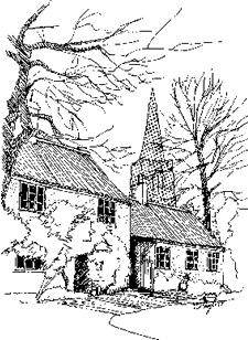
The parish church of St Helena is mostly 14th century but work from the 13th, 12th and even 11th centuries can still clearly be seen. Major restoration work took place in 1869. To the north is the mid 17th century Manor Farmhouse, whilst in a farmyard to the south of The Hall is a 14th century circular dovecote which is very similar to that at nearby Sibthorpe; these are three of six Grade II Listed buildings in the village.
Despite the simplicity of the single street form, subtle curves in the street, individual buildings and trees create an attractive sequence of views and give Thoroton a particular character of its own.
There was an expansion of the Conservation area boundary during the 2009 review. The most recent appraisal of the Conservation Area was undertaken in 2022 and formally adopted in July 2023
For further advice, contact Design and Conservation.
Documents to download
Conservation Areas in Rushcliffe
- Aslockton
- Bingham
- Bradmore
- Bunny
- Car Colston
- Colston Bassett
- Costock
- Cropwell Bishop
- Cropwell Butler
- East Bridgford
- East Leake
- Edwalton
- Flintham
- Granby
- Hawksworth
- Hickling
- Keyworth
- Kneeton
- Langar
- Normanton on the Wolds
- Orston
- Ruddington
- Scarrington
- Screveton
- Sutton Bonington
- Thoroton
- Thrumpton
- Upper Broughton
- Upper Saxondale
- West Leake
- Whatton in the Vale
- Wiverton
- Wysall