Rushcliffe Nature Conservation Strategy
Rushcliffe Nature Conservation Strategy 2026 - 2030
Foreword
We are in a global biodiversity crisis. The UK Environment Secretary in 2024, Steve Reed, in a speech said: “…we face a crisis – nature is dying, our rivers are polluted, and urgent action is paramount…Just as seeds take time to grow, we can’t fix our environment or clean up our rivers overnight – but, together, over the next weeks, months and years, we can nurture our countryside, restore nature, and build our rural economies so they bloom once more”. (DEFRA, 2024)
“England is ranked as one of the most nature-depleted countries in the world in terms of how well it has retained natural animals and plants”. (Lusardi, et al., 2024)
“Biodiversity has declined in the East Midlands… to the lowest level for any English region” (Regional Spatial Strategy for the East Midlands RSS8) (Natural England, 2009).
Rushcliffe however has amongst the lowest biodiversity of even these poor comparators.
The Environment Agency and Nottinghamshire County Council produced Environmental Scorecards for Nottinghamshire and Derbyshire in 2023, the Environmental Inequalities section of the scorecard (page 18), provides a matrix of environmental inequality indicators; for the breadth and protection of Plants and Animals, Rushcliffe scores 295 (the higher the score the worst the result), this is the worst score in Nottinghamshire and Derbyshire, with the average score across Nottinghamshire of 209 and the best score in Nottinghamshire with a score of 152 for Ashfield district (Environment Agency and Nottinghamshire County Council, 2023).
The reason for the poor biodiversity is however likely to be due to the success of the borough for farm production, leading to a long history of intensive agriculture.
Mayor of the East Midlands, Claire Ward, said: “Our region has fantastic green spaces, countryside and parks but we know that we must protect that biodiversity and our local environment not just for this generation but for the future. ( East Midlands Combined County Authority, 2024)
Section 40 of the Natural Environment and Rural Communities Act 2006 as amended by the Environment Act 2021, Section 102, states “A public authority… must… consider what action the authority can properly take… to further… the conservation and enhancement of biodiversity in England” (GOV.UK, 2021). The public bodies operating in Rushcliffe (including Nottinghamshire County Council, Rushcliffe Borough Council, Parish Council’s, Environment Agency, Highways England and others) therefore must seek to enhance biodiversity.
Local Authorities (Borough and County) must additionally publish a biodiversity report periodically, to document the policies and actions they have carried out to comply with their biodiversity duty.
The community have a great deal of interest in the natural environment of Rushcliffe, when residents are aware that sensitive wildlife sites are threatened, they are quick to show their concern. Public interest must be translated from words to action. Everyone has a responsibility to do their bit and this strategy outlines actions that statutory and voluntary organisations, businesses and individuals working together can implement.
This strategy not only sets out to try to safeguard existing known species, habitats and sites of interest, but also to encourage the creation of new sites supporting species and habitats, while seeking to address the Climate Emergency and Biodiversity Crisis. The strategy also seeks to preserve the existing links between wildlife sites and to establish new links to allow the spread of wild native plants and animals.
The objective of the strategy is not only to benefit wildlife; visitors and residents will also benefit through the opportunities to observe and enjoy nature. A wildlife-rich environment has been shown to provide health benefits and economic benefits. Properly pursued, the strategy will benefit not only those who live and work in Rushcliffe now, but also future generations.
This strategy replaces previous strategies produced between 2003 and 2020. The strategy has been developed by the Rushcliffe Nature Conservation Strategy Implementation Group (RNCSIG), which brings together statutory agencies and voluntary bodies, with the Borough Council and Nottinghamshire Wildlife Trust playing leading roles, in partnership with a wide group of groups, organisations and individuals.
This strategy supports the work of the Nottinghamshire Local Nature Recovery Strategy led by Nottinghamshire County Council (See more in section 4. Nature Recovery Network (NRN)) and the county Biodiversity Action Plan led by Nottinghamshire Biodiversity Action Group (see section 5. Nottinghamshire Local Biodiversity Action Plan (LBAP)), along with the Nottinghamshire Wildlife Trusts “Creating a Wilder Nottinghamshire by 2030” strategy (NWT, 2019).
The major organisations shown below commend this strategy. We will do our bit, please also do yours.
Rushcliffe Borough Council
Nottinghamshire Wildlife Trust
Nottinghamshire Biodiversity Action Group
Nottinghamshire County Council
Contents
- Executive Summary
- Overview of Rushcliffe's Wildlife
- Success of the Strategy 2021-2025
- Nature Recovery Network
- Nottinghamshire Local Biodiversity Action Plan (LBAP)
- Priorities for Habitats
- 6.1 Species Rich Grassland
- 6.2 Amenity Grassland
- 6.3 Rivers, Standing Water and Marsh
- 6.4 Woodland and Trees
- 6.5 Orchards
- 6.6 Hedgerows
- 6.7 Farmland
- 6.8 Garden and Urban Habitats
- Designated Wildlife Sites and Nature Reserves
- Rushcliffe Landscapes
- Landscape Ecology
- Mature Landscapes
- Trent Washlands
- Nottinghamshire Wolds - Village Farmlands
- Nottinghamshire Wolds - Wooded Hills and Farms
- Nottinghamshire Wolds - Wooded Clay Wolds
- South Nottinghamshire Wolds - Alluvial Farmland
- South Nottinghamshire Wolds - Village Farmland
- Vale of Belvoir
- Green-Blue Infrastructure
- Climate Change
- Rewilding
- Community Involvement
- Planning Policies and the Protection of Wildlife and Habitats
- Aims and Objectives
- Strategic Aim
- Objectivesl
- Key Target Indicators
- References
Appendix 1 - Rushcliffe Sites Regarded as Nature Reserves 2025
Appendix 2 - Nature Conservation Projects and Activities 2020
Appendix 4 - Other Policy Drivers
Acronyms and abbreviations used in this document
| Acronym | Description |
|---|---|
| BSI | British Standards Institute |
| CIEEM | Chartered Institute of Ecology and Environmental Management |
| CLA | Country Land & Business Association |
| CPRE | Campaign to Protect Rural England |
| CRT | Canal & River Trust (Previously British Waterways) |
| DEFRA | Department of Environment, Food and Rural Affairs |
| EA | Environment Agency |
| FWAC | Forestry and Woodlands Advisory Committees |
| GBI | Green-Blue Infrastructure |
| GNPP | Greater Nottingham Planning Partnership |
| IPCC | Intergovernmental Panel on Climate Change |
| JNCC | Joint Nature Conservation Committee |
| LBAP | Local Biodiversity Action Plan |
| LNR | Local Nature Reserve |
| LWS | Local Wildlife Site (Previously: Sites of Interest for Nature Conservation) (SINCs)) |
| MHCLG | The Ministry of Housing, Communities and Local Government’s |
| NBAG | Nottinghamshire Biodiversity Action Group |
| NBGRC | Nottinghamshire Biological & Geological Records Centre |
| NBW | Nottinghamshire Birdwatchers |
| NCC | Nottinghamshire County Council |
| NE | Natural England |
| NFU | National Farmers Union |
| NFaW | Nottinghamshire Farming and Wildlife |
| NPPF | National Planning Policy Framework |
| NRN | Nature Recovery Network |
| NWT | Nottinghamshire Wildlife Trust |
| PCs | Parish/Town Councils |
| RBC | Rushcliffe Borough Council |
| RNCSIG | Rushcliffe Nature Conservation Strategy Implementation Group |
| RuBOP | Rushcliffe Barn Owl Project (A project of Notts Birders) |
| SNG | South Notts Group (of the Nottinghamshire Wildlife Trust) |
| SSSI | Site of Special Scientific Interest |
| STW | Severn Trent Water |
| TCV | The Conservation Volunteers (Previously BTCV) |
| TVIDB | Trent Valley Internal Drainage Board |
| Vol's | Volunteers |
| WT | Woodland Trust |
1. Executive Summary
The aim of this strategy is to protect and enhance nature conservation in Rushcliffe, help mitigate the effects of climate change on wildlife and provide ready public access to wildlife rich green spaces. There will be a particular emphasis on habitats traditionally found in the borough including species-rich grassland, wetland, trees and woodland habitats, orchards, and species characteristic of the Borough such as barn owl, grizzled skipper butterflies, great crested newts, black poplar, water voles and brown hare. This will be achieved through forming effective partnerships, brought together through the Rushcliffe Nature Conservation Strategy Implementation Group (RNCSIG).
The strategy identifies a wide range of issues that affect Rushcliffe’s wildlife. It identifies that Rushcliffe’s most important wildlife is found in a scattered network of Sites of Special Scientific Interest (SSSIs) and Local Wildlife Sites (LWS).
The strategy considers the importance of the wider countryside (not just nature reserves) and urban areas in supporting our wildlife. It examines the variety of habitats and species and seeks opportunities for community involvement. The role of the planning system in conserving our natural heritage is considered. There is scope for enhancing the Borough for wildlife with appropriate long-term funding, and whether it is the creation and management of a nature reserve or the construction of a garden pond, every action has a value in enhancing Rushcliffe's wildlife resource.
Over recent decades, progress has been made on developing nature conservation projects in a co-ordinated way. Land management constraints, plus the small size and isolation of the wildlife sites, are major factors limiting wildlife in Rushcliffe. The aim of this strategy is to develop an approach to nature conservation that targets specific areas, habitats and species, to gain maximum benefit.
The strategy proposes action to promote good management of sites, habitat creation and improved green infrastructure. Such projects are not only beneficial for wildlife but provide an impetus for greater community involvement in nature conservation and improved quality of life.
Ongoing monitoring of wildlife is very important and in recent years the Phase 1 ecological survey data for Rushcliffe has been updated and digitised, however we cannot effectively protect what we do not know about, therefore continuing to survey and monitor the borough’s wildlife is vital.
The principal objectives for this strategy are to:
- Promote ‘Landscape Scale Conservation’ to create a more resilient natural environment.
- Promote the maintenance and enhancement of nature reserves.
- Promote sympathetic land management for wildlife in rural and urban areas.
- Support monitoring of Rushcliffe’s biodiversity.
- Raise awareness of nature conservation issues.
- Seek to ensure positive impacts (Biodiversity Net Gain) of development for wildlife and biodiversity whilst eliminating negative impact.
- Support and develop Nature Conservation in Rushcliffe.
The role of the Rushcliffe Nature Conservation Strategy Implementation Group (RNCSIG) is to ensure that the strategy becomes more than a list of good intentions; it produces an annual report on the progress made towards improving nature conservation in Rushcliffe. Progress requires the co-operation of a variety of organisations, groups and individuals.
2. Overview of Rushcliffe's Wildlife
An overview of Rushcliffe’s nature conservation resources is provided in the interactive online “Nature in Rushcliffe” storymap, with background detail, narrative, photos and maps covering the habitats, landscapes and species found in Rushcliffe – the storymap can be viewed, or alternatively a pdf storymap version can be downloaded.
3. Success of the Strategy 2021 - 2025
Please see details of our achievements in the annual reports published by RNCSIG and online on our Nature Conservation webpage.
Please also see the Rushcliffe Borough Council’s Biodiversity Duty report 2026 online (due to be published early 2026).
4.0 Nature Recovery Network (NRN)
The concept of Nature Recovery Networks advocates making more space for nature in both our rural and urban environments, with nature being accessible wherever people live. Whilst Nature Reserves, Local Wildlife Sites and Wildlife Corridors are central to the NRN philosophy, the linkages (hedgerows, road verges and stepping stone habitats) allowing wildlife to move, migrate and filter into urban areas are crucial. Much of this has been implicit in the thinking behind the Rushcliffe Nature Conservation Strategy for the last 20 years. But the scale envisaged for NRN`s are ambitious and delivery will be a key issue.
The Nottinghamshire Wildlife Trust report ‘Wilder Nottinghamshire’ (NWT, 2019) demonstrates this approach at a county level.
DEFRA and Natural England are promoting the creation of a Nature Recover Network across England. This “will be a national network of wildlife-rich places” connected from our towns and “cities to countryside” and “supported by green and blue spaces that buffer and connect these wildlife-rich sites” (DEFRA, 2019-22).
The Environment Act 2021 establishes a requirement for Local Nature Recovery Strategies to cover the whole of England (Crown Copyright, 2022). Nottinghamshire County Council is leading on a Nottinghamshire Local Nature Recovery Strategy (LNRS) for the whole of Nottinghamshire including the City of Nottingham. The Nottinghamshire and Nottingham LNRS will be the county’s “map for nature's recovery in Nottinghamshire and will contribute to the National Recovery Network”. (Nottinghamshire County Council, 2025). Further details are available online at Nottinghamshire and Nottingham Local Nature Recovery Strategy (LNRS)
We will seek to: Support the implementation of the national Nature Recovery Network and the Nottinghamshire and Nottingham Local Nature Recovery Strategy.
5. Nottinghamshire Local Biodiversity Action Plan (LBAP)
![]() Since 1998 the Nottinghamshire Biodiversity Action Group; a partnership of over 50 organisations working to protect and enhance biodiversity across Nottinghamshire; have worked to implement the Biodiversity Action Plan (LBAP). The plan identifies rare, important and threatened habitats and species in Nottinghamshire and provides action plans for their conservation.
Since 1998 the Nottinghamshire Biodiversity Action Group; a partnership of over 50 organisations working to protect and enhance biodiversity across Nottinghamshire; have worked to implement the Biodiversity Action Plan (LBAP). The plan identifies rare, important and threatened habitats and species in Nottinghamshire and provides action plans for their conservation.
In 2013, work was undertaken to identify and map the best opportunities to enhance areas of existing biodiversity value within Rushcliffe.
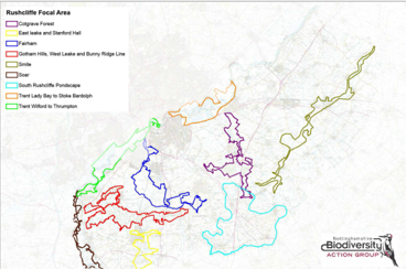
This was part of a county wide project being delivered by the BAG. This Biodiversity Opportunity Map (BOM), used existing biodiversity data alongside local amateur and professional ecological knowledge to identify locations where opportunities existed in Rushcliffe to enhance biodiversity. These enhancements included improvements to existing sites, creating buffers around these sites, creating links between these sites and creating new sites. Where a concentration of biodiversity opportunities existed, these were identified as Biodiversity Focal areas. This work will guide where future work is focused, guide planning policy, assist in the development of new projects and grant applications; it was used in preparing this nature conservation strategy.
The full Biodiversity Opportunity Mapping report is available from the Nottinghamshire Biodiversity Action Group website
We will seek to:
- Support the implementation of the Biodiversity Action Plan.
- Support the implementation of the opportunities identified in the Biodiversity Opportunity Mapping project.
6. Priorities for Habitats
The following are the priorities for habitats in Rushcliffe. For each habitat, this strategy will seek to:
6.1 Species Rich Grassland
- Protect and manage remaining fragments of species-rich grassland.
- Encourage sympathetic management of other grassland and examine options to create/extend species rich grassland.
- Work proactively with landowners / managers in the borough to develop and implement wildlife sensitive management plans.
- Encourage the public to develop wildflower grasslands through provision of appropriate wildflower seed.
- Support the enhanced management and extension of the County Notified Road Verge scheme and other important roadside verges.
- Promote appropriate mowing regimes on road verges and protection from excessive winter salting.
- Raise awareness of the need to use local species / sub species seed, especially in rural areas and on sensitive wildlife sites.
6.2 Amenity Grassland
- Ensure grasslands owned by public bodies are managed as wildflower rich grasslands wherever appropriate.
- Encourage communities to develop wildflower grasslands through provision of appropriate wildflower seed.
- See also section 6.8 Garden and Urban Habitats
6.3 Rivers, Standing Water and Marsh
- Protect the remaining marshland fragments and encourage the development and management of wetland sites.
- Carefully consider and liaise over the future redevelopment of the Grantham Canal and its surroundings; 'Work with the CRT, riparian authorities, landowners and local groups to address water loss and improve the ecology along the Grantham Canal.
- Promote farm and garden pond creation and management.
- Work to stop the decline of water voles and to support the return of the otter.
- Control invasive, non-native species.
- Work towards ‘good ecological status’ of our rivers, streams and waterbodies.
- Encourage riparian owners to slow water ingress to water courses by use of Natural Flood Management techniques where appropriate.
6.4 Woodland and Trees
The UK Government has a target to increase tree cover in England to 16.5% by 2050 (Stanford & Spain, 2023).
The Woodland Trust - Woodland Access Standard recommends that everyone should live within 500m of an accessible woodland of at least 2 hectares and within 4km of an accessible 20 hectares wood (WT, 2015).
We recommend in any woodland and tree work that is carried out, you follow the councils policies.
Additionally advice on suitable trees and shrubs for planting within Rushcliffe is provided online.
Further policies in relation to new developments are provided in the Rushcliffe Local Plan Part 2:
Land and Planning Policies – Section 12, especially Policy 37, online (please note the Local Plan may be updated within the life of this Strategy) and the Rushcliffe Design Code online.
Advice on the management of new trees.
Dead wood has ecological value, the UK Woodland Assurance Standard (UKWAS) makes recommendations for deadwood management. (WT, 2019)
This strategy will seek to:
- Work torwards achieving the national targets for tree cover and woodland access. Achieve at least 20 hectares of new woodland cover (approx. 20,000 trees) within this plan period
- Promote appropriate new woodland planting and / or regeneration, particularly linked to existing woods.
- Ensure planning policies on trees and woodland are implemented and work toward national targets.
- Promote sympathetic woodland management, including retaining ivy where appropriate.
- Retain standing dead wood and lying dead wood where possible, (considering health and safety constraints and, reducing the canopy of standing dead wood as necessary).
- Consider creating dead wood habitat by veteranisation of trees.
- Establishing new and managing existing woodlands and trees outside woodlands for carbon offset.
- Continue / develop schemes to establish new trees outside woodlands (including the use of resident and community tree schemes).
- Protect veteran trees and use tree preservation orders for threatened valuable amenity trees.
- Enable Rushcliffe tree wardens to protect and enhance trees.
- Encourage use of locally sourced and locally native trees.
6.5 Orchards
- Promote the good management of traditional orchards.
- Develop schemes to support management existing traditional orchards and establish new sympathetically managed community orchards.
- Use planning policy and BNG encourage the retention and management of traditional orchards.
6.6 Hedgerows
- Promote conservation, replanting and appropriate management of hedgerows.
- Increase the length of hedgerows in Rushcliffe by 40% (increase by 626km from 2021 baseline estimate of 1,564km)
- Use planning and BNG regulations to ensure new and improved hedgerows are provided on new developments.
- Use the Hedgerow Regulations as appropriate to retain important hedgerows.
- Undertake surveys of the condition of hedgerows in the borough.
6.7 Farmland
- Encourage farmers and other landowners to develop sympathetic management practices and increase the take up of schemes that support this.
- Protect and develop farm ponds, ditches, the margins of arable farm fields, hedgerows and other habitat enhancements.
- Encourage farmers to retain traditional pasture, meadows and autumn arable stubble.
- Encourage the appropriate use of agro-forestry.
- Support the National Pollinator Strategy and implement local pollinator actions.
- Reduce agricultural pollution, including nature based diffuse pollution control measures such as buffer strips alongside sensitive features including watercourses.
- Raise awareness of urban wildlife, protected species and invasive non-native species.
- Protect and enhance urban wildlife sites, including wildlife rich ‘brown-field’ sites.
- Encourage recreational use of urban nature sites where appropriate.
- Encourage wildlife-friendly gardening by providing advice and Tree and Wildflower Seed schemes
- Enhance the potential of both new and existing buildings for use by wildlife, through advice and policies as appropriate.
7. Designated Wildlife Sites and Nature Reserves
The UK has signed up to a pledge to protect at least 30% of the planet's land and waters by 2030 to halt and reverse nature loss (the 30x30 pledge).
Designated sites are those sites that have been declared important for their wildlife, these may be by statutory designations such as Sites of Special Scientific Interest (SSSIs) or Local Nature Reserve (LNR’s); or by non-statutory designations such as Local Wildlife Sites (LWS).
No internationally designated sites are found in Rushcliffe.
Detail on designated sites found in Rushcliffe can be viewed in the “Nature in Rushcliffe” storymap.
Nature reserves are those sites managed with nature conservation as a primary objective. Sites we are aware of that are managed as nature reserves are listed in the annual reports published by RNCSIG.
The Countryside and Rights of Way Act 2000 impose a duty for public authorities to show regard for conserving biodiversity in all their actions including the conservation and enhancement of Sites of Special Scientific Interest (SSSI). National Planning Policy Framework (2019) - Part 15 – ‘Conserving and enhancing the natural environment’ makes specific reference to the need to safeguard ‘locally designated sites’, which includes Local Wildlife Sites (LWS).
All of these sites are important and need protecting. Targeting the areas with the greatest numbers of important sites can help to protect them, ensuring their long-term survival and development.
Finance can also be an issue; obtaining grant funding can be difficult and time consuming. Rushcliffe Borough Council, with oversight from partners provides grants to provide small amounts of money, simply.
Comparing the area managed as nature reserves (552 hectares) with the total coverage of LWS (1,900 hectares) or of Rushcliffe (41,000 hectares), then 1.3% of Rushcliffe is managed as nature reserve; while the total coverage of LWS (1,900 hectares) has 4.6% of Rushcliffe designated as LWS, this shows that management of nature reserves, whilst important, cannot be regarded in isolation. The wider management of land and networks linking reserves, LWS and SSSIs is essential.
Some sites are publicly owned, and some are privately owned, nature conservation may be a secondary purpose or in some cases of little interest to the owners.
We will seek to:
- Ensure protected sites and reserves are well managed; with management agreements and plans, advice and grants.
- Identify and designate new sites.
- Extend existing sites to provide buffer zones and reduce isolation.
- Monitor sites to prevent degradation, using regulations where necessary.
- Ensure sufficient resources are available (both financial and volunteer) to support implementation of plans.
- Seek to build the capacity of the nature conservation sector in Rushcliffe (both professional and voluntary).
- Develop large (landscape scale) sites and reserves in Rushcliffe.
8. Rushcliffe's Landscapes
Landscape Ecology
Landscape affects species viability, of particular concern is the ability of species to move through the landscape and the size of wildlife sites and habitat within the particular landscape.
Landscape ecology suggests the greatest value for wildlife can be gained by developing further similar habitats to those already present. Woodland planting is best concentrated into areas of existing woodland; in Rushcliffe, this would be the Nottinghamshire Wolds and in the Cotgrave area. In the South Nottinghamshire Farmland and the Vale of Belvoir it would be more important to improve farmland habitats by for example developing wildflower rich grasslands, native farm hedgerows, hedgerow trees and field corner plantations, field margins, beetle banks, overwinter stubble, lapwing lawns, barn owl boxes and farm ponds.
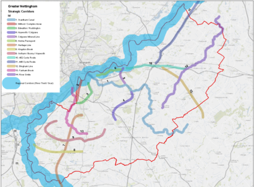
Areas that allow wildlife to move through the Borough are known as green corridors. Green corridor maps help to focus efforts to reduce fragmentation (see also Green Infrastructure).
We will seek to:
- Update and maintain Green Corridor maps for the borough, clearly defining important corridors.
- Protect existing green corridors.
- Seek appropriate farmland enhancement and woodland creation.
- Pursue opportunities to enhance the corridor network and encourage land managers to improve connections between habitat sites.
- Identify clusters of wildlife sites and seek to improve connection and reduce fragmentation and isolation of sites.
Mature Landscapes
Areas with landscape features that have been long established tend to be better for wildlife. Nottinghamshire County Council’s Mature Landscape Survey, reviewed in 1997, identifies landscapes considered to be amongst the most precious and relatively unchanged since the mid-19th century.
Ridge and Furrow grasslands are a feature often found in mature landscapes and often have good species diversity.
Further information on historical features is provided on the county council Historic Environment Record, online.
We will seek to:
Protect mature landscape areas as far as possible from adverse development.
Landscape Character

Landscape character areas have been identified across the borough as shown in the map above (more detail about landscape character is given in the storymap).
Wildlife including tree species varies according to the character area; the most appropriate tree and shrub species for the landscape character area should be used for planting schemes wherever possible. Recommended tree planting species for each Landscape Character Area are provided online.
More details about the landscape character assessment.
Key actions for each Landscape Character area in Rushcliffe are set out below:
Trent Washlands
- Encourage the protection and restoration of mixed hedgerows and field margins, hedgerow and riparian habitats and trees including willow pollards.
- Protect pastures and meadows where they survive.
- Consider recreating grassland (especially wet pasture) and marsh.
- Protect the parkland landscape around Kingston Hall.
- Maintain and develop woodlands on steep bluffs and create small wet woodlands within the river valleys.
Nottinghamshire Wolds
Village Farmlands
- Encourage field hedgerows and trees.
- Encourage calcareous grasslands on gypsum areas.
- Protect woodland and veteran trees in the parkland landscape at Stanford Hall.
- Encourage riparian habitats and trees (especially willow pollards) and shrubs along with grassland along the Kingston Brook corridor and discourage arable farming to the brook edge.
- Install natural flood defences and nature based diffuse pollution control measures on stream headlands.
Wooded Hills and Farms
- Encourage field hedgerows and trees.
- Develop grasslands on gypsum.
- Protect woodland and veteran trees in the parkland landscape at Stanford Hall.
- Encourage riparian habitats and trees (especially willow pollards) and shrubs along with grassland along the Kingston Brook corridor and discourage arable farming to the brook edge.
- Install natural flood defences and nature based diffuse pollution control measures on stream headlands.
Wooded Clay Wolds
- Increase broadleaved woodland cover especially on hilltops using field patterns as a guide.
- Look to diversify the woodland around Cotgrave.
- Encourage hedgerow management.
- Protect remaining grasslands especially ridge and furrow.
South Nottinghamshire Farmland
Alluvial Farmland
- Seek improvements to the River Smite (re-profiling and encouraging aquatic and emergent vegetation).
- Improve riparian structure along the rivers Smite and Devon.
- Consider enlarging copse and repairing remaining hedgerows.
- Consider the creation of wet grassland especially within Ruddington Moor.
- Encourage the creation of beetle banks, game cover strips, headlands and maintenance of winter stubble on arable farmland.
- Encourage pond creation and management to help support wetland species.
- Install natural flood defences and nature based diffuse pollution control measures on stream headlands.
Village Farmland
- Protect and develop hedgerows and hedgerow trees.
- Encourage the creation of beetle banks, game cover strips, headlands and winter stubble on arable farmland.
- Encourage ponds creation and management.
- Protect and enhance parkland habitats.
- Protect and enhance the Grantham Canal and disused railway habitats.
Vale of Belvoir
- Promote pasture and hay meadows especially along the river edges, grass headlands, hedgerows, hedgerow trees, riparian buffer strips and trees.
- Encourage wood planting on escarpments.
- Seek improvements to the River Smite (re-profiling and encouraging aquatic and emergent vegetation).
- Install natural flood defences and livestock control measures on stream headlands.
- Protect and enhance parkland habitats.
9. Green-Blue Infrastructure
Green-Blue Infrastructure (GBI) is used to describe the land around us which has not been built on or cultivated. This may be recreational, landscape and ecological in nature, but in the same way as roads and electricity wires are called infrastructure because they benefit people, these areas can also provide a range of benefits. This includes aquatic or blue infrastructure features.
Natural England defines Green Infrastructure as “a strategically planned and delivered network comprising the broadest range of high-quality green spaces and other environmental features”. It identifies key benefits as “able to deliver multiple environmental functions, and to play a key part in adapting to and mitigating climate change” and “support healthier lifestyles by providing green routes for walking and cycling, and green spaces for exercise and play” (Natural England, 2009).
Green and Blue Infrastructure covers a wide variety of open spaces, including water and wetland environments. There is a clear overlap between GBI and ecological networks which seek to prevent the ecological isolation of sites through the creation of wildlife corridors and stepping stones. These provide habitats for species and enable their migration.
Green-Blue infrastructure can range from small green spaces, such as domestic gardens and street tree avenues, to playing pitches and recreation grounds, river corridors, canals and lakes, cycle routes, local nature reserves and woodlands.
Multi-functionality is a key element of Green and Blue Infrastructure… providing accessible sport and recreational opportunities, wildlife habitats and an ecological corridor, reduces local temperatures, and offers non-motorised transport opportunities… provide flood water storage during periods of heavy rainfall, reducing risks of flooding. (GNPP, 2022).
By looking at the Green-Blue Infrastructure we already have, it is possible to identify what needs to be maintained and enhanced, as well as identify where there are gaps and opportunities to improve our GBI. A coherent GBI strategy helps reduce biodiversity loss and habitat fragmentation. The pressure for new housing developments in Rushcliffe highlights the importance of planning our GBI.
Greater Nottingham Green Blue Infrastructure Strategy 2022
- Maintain an inventory of our Green-Blue Infrastructure.
- Implement a strategy on managing and enhancing this resource and develop projects to improve the Green-Blue Infrastructure of Rushcliffe.
- Work with the planning authorities and developers to avoid development that destroys or damages GI and to ensure wildlife friendly Green-Blue Infrastructure is included in all new strategies and developments.
10. Climate Change
The climate of our world is changing due to man's activities, and this will impact on both our society and the natural world. For example, in the UK oak trees are opening their leaves up to a fortnight earlier than 50 years ago, species that are dependent on oak trees which cannot adapt to this change will struggle to survive. Similarly, it has been shown that “Britain’s climate zones are moving northwards by up to five kilometres a year due to climate heating” … “according to the IPCC, carnivorous mammals can disperse at 6km/year (median estimate), while split-hoofed mammals (like deer) can shift their ranges at 9 km/year. Rodents are less mobile, however, generally shifting at less than 1km/year... butterflies in North America and the UK have shifted at 2-4 km per year” (Rewilding Britain, 2020) .
We all have a responsibility to reduce our impact on the environment, but we must also help our wildlife to adapt to the changing climate. This means there needs to be a range of good quality and varied habitats for species to live in, supported by good linkages to allow movement where required – a coherent GI strategy. “Enhancing the scale, quality and connectedness of our native habitats would enable more species and communities to adapt and adjust their ranges as climate zones shift, by the creation of core rewilding areas across at least 5% of Britain and the establishment of ‘natural dispersal corridors’ across at least 25% of Britain. This could save… Britain’s species from climate-driven habitat loss, species decline or even extinction (Rewilding Britain, 2020)”.
We must also seek to minimise the stresses on wildlife which when added to climate change could lead at the very least to local extinctions or worse. But we must also be prepared for new species to become part of Rushcliffe’s biodiversity.
Mitigation of climate change needs to take place in the built environment in existing and new developments to achieve net zero emissions. Climate change mitigation in buildings includes very high standards of insulation, micro and community renewable energy and infrastructure to encourage walking, cycling and the use of low carbon public transport.
It is likely however that carbon emissions will still be produced, ecosystems can absorb carbon, known as carbon sinks, allowing emissions to reach net zero. Carbon sinks include trees and woodlands, hedgerows, long term diverse grasslands and some wetlands, rewilding is one method for increasing these habitats.
We will seek to:
- Maintain as diverse an environment as we can to support the widest opportunities for our biodiversity to survive.
- Increase linkages between habitats to allow movement of species.
- Be prepared to adapt our efforts as the climate changes.
- Support efforts to mitigate climate change, by all partners, including the use of nature based solutions to act as carbon ‘sinks’, for example by tree planting and rewilding and to support the aim to meet Net Zero emissions before 2050 as a borough.
11. Rewilding
"Rewilding is the large-scale restoration of ecosystems to a point where nature can take care of itself. It seeks to reinstate natural processes and, where appropriate, missing species – allowing them to shape the landscape and the habitats within...rewilding can provide a cost-effective solution for the mitigation of climate heating with its ability to draw down millions of tonnes of carbon from the atmosphere”
CIEEM states rewilding is part of a wider ‘conservation toolkit’ that can be used alongside traditional management techniques (CIEEM, 2020). Opportunities are limited in Rushcliffe due to the intensity of land use, but agricultural land and riversides may provide possibilities.
We will seek to:
- Find opportunities to create rewilding areas.
12. Community Involvement
Public bodies and various community organisations carry out valuable nature conservation work in the Borough, but individuals (especially landowners) also carry out large scale work which benefits wildlife in the wider countryside. It is vital to include farmers in nature conservation as they manage most of the land and there are many examples of good stewardship in Rushcliffe.
Nottinghamshire Biological and Geological Records Centre (NBGRC) maintain records of survey work and undertakes much survey work. The NBGRC is responsible for holding, interpreting and updating all data associated with the LWS system. Charities like Nottinghamshire Wildlife Trust, Notts Birders and Butterfly Conservation are also active in the area, along with Nottinghamshire Biodiversity Action Group.
Access to nature conservation sites and the wider countryside develops awareness of our natural heritage, while also providing other ecosystem service benefits, appropriate access should be encouraged and managed, without putting too much pressure on these sites. Natural England advocates ‘Access to Natural Greenspace Standards’ (ANGSt) (Natural England, 2003) so that that everyone, wherever they live, should have an accessible natural greenspace.
Education, both formally (where taught) and informally (for example using information panels on nature reserves, walks and talks), helps to raise awareness of nature conservation issues. It is important to educate as widely as possible, addressing both adults and young people and by publicising conservation issues and activities locally.
Community involvement in nature is important; nature conservation work improves our natural heritage, our social wellbeing, health and economy. Public involvement is limited by the availability of organisers (voluntary and professional) and funding. Although there is already much community involvement in Rushcliffe, there is potential for engaging with new individuals and groups. Examples of such engagement include Friends of Groups, South Notts Local Group, Forest Schools, Rushcliffe Wildlife Watch and Rushcliffe Rangers.
Friends of Groups are valuable community groups that care for particular sites and carry out a large range of activities, from practical habitat management, survey and monitoring, educational activities, fundraising, through to leading guided walks and encouraging new members of the community to become involved with activities on these sites. In addition, groups such as Rushcliffe Barn Owl Project
(part of Nottinghamshire Birdwatchers) and the South Notts Ringing Group carry out more specialised activities.
The widest possible variety of media and communications methods, including social media platforms helps to reach as many residents as possible. Appendix 3 provides the communications plan for the strategy group.
The nature strategy has contributed to a steady growth of local community action by committed groups and individuals over the years and we must continue to support existing local action, as well as the development of additional initiatives, both big and small. We will also continue promoting volunteer involvement in county based and national projects that will benefit our local wildlife. Actions in this area particularly contribute to Strategic Objectives 2, 4, 5.
We will seek to:
- Support community involvement in nature conservation in Rushcliffe, through voluntary conservation work, wildlife surveying and awareness raising, this requires funding to be sought; training and interpretative material to be provided and activities to attract the public.
- Support existing ‘friends of groups’ and seek to develop new groups.
- Provide access to wildlife sites and support initiatives that care for the environment.
- Implement Natural England’s ANGSt standards.
- Take care that activity is carried out on sites across the whole Borough, not just popular areas.
13. Planning Principles and the Protection of Wildlife and Habitats
The National Planning Policy Framework (NPPF) was first published on 27 March 2012 and has been updated, the last update was published on 7 February 2025 (MHCLG, 2024). This sets out the Government’s planning policies for England and how these are expected to be applied. A principle set out in the NPPF is that “The purpose of the planning system is to contribute to the achievement of sustainable development, including… to protect and enhance our natural, built and historic environment; including making effective use of land, improving biodiversity, using natural resources prudently, minimising waste and pollution, and mitigating and adapting to climate change, including moving to a low carbon economy”. (MHCLG, 2024)
There is major pressure at a national and regional level for significant housing development to occur. In order to meet the housing needs of Nottingham and outlying settlements, it is likely that pressure for significant development within Rushcliffe will continue including 11,960 homes to be sited across Rushcliffe between 2023 and 2041 (GNSP, 2025), thus Rushcliffe`s wildlife sites in both urban and rural areas will come under pressure from development in the coming years. A degree of protection is provided by national and local planning policies. National regulations also require additional environmental assessments for those developments likely to have a significant environmental impact.
The local planning policy documents created by the local planning authority set out where and how development will be allocated, they also identify areas where certain developments are constrained, for example by legally protected species and important trees, woodlands and hedgerows. These documents also include policies relating to planting schemes that emphasise appropriate local species. In accordance with national policy, the Local Plan also identifies important ecological networks (based on Biodiversity Opportunity Maps). Within these areas developments must ensure the network of habitats is maintained and enhanced.
The Rushcliffe Local Plan forms the statutory development plan for the Borough, Part 1 covers the core strategy (RBC, 2014). and Part 2 - Land and Planning Policies (LAPP), including details of identified sites. The Part 2 document also states, “Policies in this Local Plan Part 2 regarding nature conservation should be read alongside … Rushcliffe’s Nature Conservation Strategy”. (RBC, 2019)
The concept of Biodiversity NET Gain is a key part of both NPPF and Rushcliffe Local Plan policy documents, which commit to “Protecting and improving natural Assets” including ensuring an increase in biodiversity, enhancing and developing the network of green spaces, protecting ancient and veteran trees and replacing any lost trees”. The documents set out where and how development will be allowed, identify protected areas, legally protected species and important trees, woodlands and hedgerows. These documents also include policies relating to planting schemes that emphasise appropriate local species. New developments are expected to contribute to green infrastructure networks and open space provision.
It is important to ensure that where development is permitted, in addition to Biodiversity Net Gain, valuable sites (SSSI, LWS and LNR) and other hard to replace sites, habitats (including ancient woodland and traditional meadows) and species are protected from direct development and a ‘mitigation hierarchy’ is followed, that seeks to avoid ecological harm, and where necessary mitigates or compensates for losses (Section 193, NPPF).
Biodiversity Net Gain is development that leaves biodiversity in a better state than before. Biodiversity net gain complements and works with the biodiversity mitigation hierarchy set out in the NPPF at paragraph 193. It does not override the protection for designated sites, protected or priority species and irreplaceable or priority habitats set out in the NPPF. Local planning authorities need to ensure that
habitat improvement will be a genuine additional benefit and go further than measures already required to implement a compensation strategy.
The majority of Town and Countryside Planning Act planning applications require assessment for their provision of Biodiversity Net Gain from 12 February 2024 for major developments and 2 April 2024 for small sites. Developers must deliver a minimum of 10% BNG where the development is not exempt. The Greater Nottingham Strategic Plan draft strategy proposes a higher target of 20% applies in Rushcliffe Borough (See 3.17.12 (GNSP, 2025)), this should be introduced through the replacement Rushcliffe Local Plan.
Where the gains are significant (i.e. more than 0.5 units of medium or higher distinctiveness) a planning obligation will be required to secure the delivery.
All sites identified in the Nottinghamshire and Nottingham Local Nature Recovery Strategy as “Areas that Could Become of Particular Importance for Biodiversity” (ACBs) and all sites with habitats listed in the Nottinghamshire and Nottingham Local Nature Recovery Strategy with ‘proposed Measures’ (even where those measures are not mapped); will be considered as “Formally identified in local strategy” for strategic significance in BNG metrics.
More detail is provided on the Biodiversity Net Gain webpage.
In addition to habitat gains, it is expected that developments should usually include built enhancements including artificial bird nests (including for swifts and swallows and house sparrows and where appropriate barn owls) and bat roosts; these should be permanent or long-life enhancements, either built into the fabric of the development or of a woodcrete type fabric. Hedgehog gates should be included in fences and hibernacula created where appropriate for reptiles and amphibians. Insect boxes / hotels are also recommended. See Natural Environment paragraph 23 and section T2.10 of the Biodiversity Net Gain Good Practice Principles for Development and Ecological Standing Advice for Planning Applications in Rushcliffe - Protection of species, sites and habitats.
Local Sites should be buffered from developments Green Infrastructure should be included in developments reducing the threat of isolation and bringing wildlife into new developments.Sustainable Urban Drainage schemes (SUDs) where required should be designed to provide ecological benefit. Further guidance is provided on the Rushcliffe Design Code page.
Care is required in determining the importance of habitats. Brownfield sites can in some cases be valuable wildlife habitats (i.e. disused railways and pitheads). Green field sites may be intensively managed arable and pasture with limited current wildlife value, however they may also have a considerable potential for wildlife habitat creation.
The government attaches great importance to Green Belts. The fundamental aim of Green Belt policy is to prevent urban sprawl by keeping land permanently open; the essential characteristics of Green Belts are their openness and their permanence (MHCLG, 2019c). A large part of the Borough (40%) falls within the defined Nottingham-Derby Green Belt that encircles Greater Nottingham. Greenbelt boundaries should only be altered in exceptional circumstances and make as much use as possible of previously-developed or ‘brownfield’ land, except where this would cause harm to designated sites of importance for biodiversity. Before concluding that exceptional circumstances exist to justify changes to Green Belt boundaries and removal of further land from the greenbelt, the strategic policy-making authority should be able to demonstrate that it has examined fully all other reasonable options for meeting its identified need for development, including explicit consideration of the factors outlined in paragraph 137.
Local communities are encouraged to consider producing a Neighbourhood Plan for villages that don't yet have one. Once adopted these form part of the Development Plan for the Borough and allow local insights into the biodiversity, Green Infrastructure and local, ecologically valuable sites, they can also highlight appropriate sites for development. National guidance (MHCLG, 2020) sets out what
Neighbourhood Planning is and what it can do. Rushcliffe Borough Council publishes Neighbourhood Plans on its website.
Developers should be encouraged to meet the highest standards of development for nature conservation, for example British Standard 42020, Biodiversity – Code of practice for planning and development (BSI, 2013) or the Building with Nature standards and accreditation scheme. (Building with Nature, 2020).
Developers should always provide an ecological construction method statement incorporating reasonable avoidance measures (RAMs).
The use of external lighting (during construction and post construction) should be appropriate to avoid adverse impacts on bat populations, see Bat Conservation Trust - artificial lighting guidance and CIEEM bat mitigation guidelines for advice and a wildlife sensitive lighting scheme should be developed and implemented.
It is recommended that developers check their sites using the free online tool for householders and small to medium-scale developers to check whether they will need expert ecological advice before submitting a planning application, the report produced by this tool can be used to support the planning application. (This tool is not intended for large development projects where formal Environmental Impact Assessments (EIA) are required according to EIA regulations).
See GOV.UK - Natural Environment for national guidance on planning and environmental issues.
Where levels of pollution (including light and noise pollution) may be detrimental to wildlife, sources should be traced and if possible reduced to acceptable levels. Various organisations have specific roles in controlling levels of environmental pollution, principally the Environment Agency and Rushcliffe Borough Council.
We will seek to:
- Ensure wildlife issues in planning policies are updated as required and implemented, with appropriate guidance and supplementary documents.
- Support the use of biodiversity opportunity maps to guide planning policies to improve biodiversity in the borough.
- Ensure planning applications are fully assessed and considered with respect to wildlife protection regulations and policies. Follow good practice on planning and biodiversity, particularly following the ‘mitigation hierarchy’ where compensation for habitat loss should be a last resort.
- Include measurable Biodiversity Net Gain in all new developments unless the development is exempt.
- Encourage the development of Biodiversity Gain sites for offsite BNG within Rushcliffe.
- Minimise the need to use important nature conservation sites for development.
- Keep nature conservation on the agenda at county, regional, national and international levels.
- Work with Parish and Town Councils to promote the inclusion of wildlife friendly policies with Neighbourhood Plans and support their implementation.
- Encourage developers to use the highest nature conservation standards.
- Enforce pollution regulations and support policies to reduce environmental pollution, including seeking to achieve “good ecological status” for waterbodies.
- Encourage individuals and companies to adopt safe and sustainable working practices to avoid harm to wildlife.
14. Aims and Objectives
To protect and enhance nature conservation in Rushcliffe, help mitigate the effects of climate change on wildlife and provide ready access to wildlife rich green spaces. There will be a particular emphasis on species-rich grassland, wetland, orchards and woodland habitats, and species characteristic of the Borough such as barn owl, grizzled skipper butterflies, great crested newts, black poplar, water voles and brown hare. This will be achieved through forming effective partnerships, brought together through the Rushcliffe Nature Conservation Strategy Implementation Group (RNCSIG).
- Promote Landscape Scale Conservation to create a more resilient natural environment, by:
- Continue using the Focal Areas identified in the Biodiversity Opportunity Matching Mapping exercise and also the Areas that Could Become of Particular Importance for Biodiversity (ACBs) identified in the Nottinghamshire Local Nature Recovery Strategy to target action for landscape scale nature conservation projects. (Partners: RNCSIG, NWT, RBC)
- Seeking opportunities for delivery of aspirational large-scale projects, with particular emphasis on improving connectivity across the landscape or catchments. (Partners: RNCSIG, NWT, RBC, PCs)
- Provide advice and support to organisations whose land holdings or interests have a significant role in nature conservation in Rushcliffe. These might be private landowners, businesses, parish councils, Friends groups and other organisations. (Partners: NWT, RNCSIG, RBC, NCC, CRT, NBAG, TVIDB)
- Support the development of the holistic Nature Recovery Network concept and plans for Rushcliffe and the county in order to make our wildlife sites better, bigger and more connected. Partners: NWT, NCC, RBC, RNCSIG, Friends Groups)
- Promote the maintenance and enhancement of nature reserves, by:
- Seeking to ensure that all nature reserves have a current Management Plan. (Partners: NWT, RBC, PCs, Friends Groups)
- Seeking to ensure that all nature reserves have sufficient resources available to deliver the management plan and assist with provision of resources wherever possible. (Partners: NWT, RBC, NCC, NE, EA, Businesses, PCs, Friends Groups)
- Encouraging local community involvement in the management of nature reserves. (Partners: NWT, RBC, Friends Groups, PCs, TCV, SNG)
- Support local communities in establishing and designating Local Nature Reserves (Partners: NWT, RBC, Friends Groups, PCs)
- Promote sympathetic land management for wildlife in rural and urban areas, by:
- The sympathetic protection and management of Local Wildlife Sites (LWS) through provision of advice and / or signposting to useful resources. (Partners: NWT, NFaW, NFU, DEFRA, NBW, CLA, NE)
- Encouraging farmers to develop sympathetic management practices and increase the take up of agri-environment schemes through provision of advice or signposting to useful resources. (Partners: NFaW, NWT, NFU, RuBOP / NBW, CLA, NE)
- Encouraging wildlife friendly management of buildings, corporate landscaping, public open space, school grounds and private gardens by provision of advice or signposting. (Partners: RBC, NCC, NWT, CRT, EA)
- Supporting programmes to benefit national priority species and habitats, Nottinghamshire Biodiversity Action Plan Priority species and habitats, habitats identified in the LNRS Statement of Biodiversity Priorities and LNRS Species Priorities List species (especially neutral and calcareous grasslands, native woodlands and wetlands) as appropriate. (Partners: NWT, NBW, RBC, EA, NBAG, TVIDB)
- Promoting the management of the existing Notified Road Verges and work with partners to maintain existing habitat and create additional habitats alongside our transport corridors. (Partners: NCC, Via East Mids, Highways England, Network Rail, RBC, NWT, CRT, TRT)
- Protect enhance and expand appropriate tree and woodland cover in Rushcliffe working towards achieving the national targets for woodland and urban tree cover and woodland access. (Partners: RBC, NWT, Tree Wardens, PCs, Friends Groups. EA and Landowners)
- Supporting projects that benefit our freshwater environment (rivers, ditches, ponds, lakes, canals and reservoirs), tackling water quality issues and benefiting aquatic habitats and species. This will involve working on a catchment level, engaging with relevant catchment partnerships (Partners: RBC, EA, CRT, GCS, STW, NCC, NWT, TRT, PCs, Friends Groups and Landowners)
- Support monitoring of Rushcliffe’s biodiversity, by:
- Liaising with and working in closer partnership with NBGRC in relation to species monitoring and the Local Wildlife Site network. (Partners: NWT, RBC, NCC, NBGRC, Friends groups)
- Promoting participation in species survey programmes, as well as encouraging local initiatives to record wildlife, ensuring that records are submitted to the relevant recorders or groups. (Partners: NBGRC, NWT, RBC, specialist wildlife groups)
- Supporting the work of the Notts Biodiversity Action Group by promoting BAG activities and reporting against LBAP targets. (Partners: NWT, RBC, SNG, NCC, NBAG)
- Raise awareness of nature conservation issues by:
- Publicising the work of partners and local nature conservation groups, as well as wildlife related issues through news releases and social media posts. (Partners: NWT, RBC, RCC, NBW, NCC, TCV, Friends Groups)
- Extending wildlife education opportunities by supporting youth wildlife groups and enhancing wildlife education programmes in schools, colleges, universities and Adult Education. (Partners: NWT, RBC, NCC, educational providers, uniformed groups)
- Promoting contacts, exchange of knowledge and resource sharing amongst groups and organisations associated with nature conservation locally by running events such as the Conservation Volunteer’s Forum. (Partners: RBC, NWT, SNG, NBAG, Friends Groups)
- Promoting access to wildlife and countryside, specifically promoting disabled access where appropriate by circulating promotional materials and maintaining relevant websites. (Partners: RBC, NCC, NWT, SNG)
- Seek to ensure positive impact (Biodiversity Net Gain) of development on wildlife and biodiversity whilst eliminating negative impact, by:
- Ensuring that local planning policies relating to biodiversity and environmental issues are based on the principles set out in the National Policy Planning Framework, Environment Act 2021 and national best practice in terms of protection, mitigation and enhancement. (Partners: RBC, NWT, CPRE, PCs, NCC, NBAG, EA)
- Ensuring that opportunities are taken to benefit people and wildlife through the design of buildings and green blue infrastructure and seek to implement Natural England’s ANGSt standards and national best practice. (Partners: RBC, NCC, CLA, NFU, NE)
- Using Hedgerow Regulations and Tree Preservation Orders to help protect important features. (Partners: RBC, NCC, NWT)
- Implementing policies to reduce levels of environmental pollution; seek to achieve good ecological status for rivers; and to mitigate and adapt to climate change. (Partners: RBC, Catchment partners, NCC, EA, NWT, TVIDB)
- Seeking to influence Regional, National and International decision making to promote wildlife friendly policies by commenting on relevant consultations. (Partners: NCC, RBC, NE, NWT, EA, NDLNP, TRT)
- Promoting the use of native local provenance planting by signposting to current best practice guidelines (Partners: RBC, NCC, NWT)
- Supporting the Rushcliffe Nature Conservation Strategy, by:
- Continued support for the Rushcliffe Nature Conservation Strategy Implementation Group (RNCSIG) in helping deliver the strategy's objectives. (Partners: RBC, NWT, NBAG, Friends Groups)
- Producing an annual report on what has been achieved to progress nature conservation in Rushcliffe and the deficiencies that need to be addressed. (Partners: RNCSIG)
- Reviewing the strategy during 2030, or sooner if appropriate. (Partners: RNCSIG)
15. Key Target Indicators
The following criteria are indicators of progress made in the various sections of the Aims and Objectives and are intended to be measurable and achievable:
- Percentage of nature reserves (as listed in Appendix 1) with current management plans. Target = 100% sites (Objective 2).
- Hours of practical work carried out on nature reserves by volunteers. (Baseline in 2024 = 9,844 hrs. Target = Maintain year on year across the Borough (Objective 2).
- Number of barn owl boxes installed and available for use and number of barn owl chicks raised in boxes. Target = maintain number of boxes available for use and sustain the number of barn owl chicks raised (Objectives 3, 6).
- Percentage of nature reserves with wildlife related public events (at least one per year). Target = 70% of sites with at least one event per year (Objective 5).
- Percentage of Parishes / West Bridgford Wards with publicly accessible natural green spaces (from a base of 48% in 2018). Target = 1 more parish / ward with at least one accessible natural green space by 2030. (Objective 6)
- Number of Local Wildlife Sites (LWS). Target = No net loss of Local Wildlife Sites (Objectives 1, 2, 3, 4, 6).
- Percentage of Tree cover in Rushcliffe. Target = increase up to a minimum of 16.5% across Rushcliffe from a base of 11.1% in 2020 and 12.27% in 2025 (Objective 3).
- Area of BAP habitat created, restored or bought under active conservation management in order to link or buffer existing wildlife habitat. Target = 30 hectares of grassland, 10 hectares of woodland, 10 hectares of wetland between 2020 and 2025 (Objectives 1, 2, 3, 4).
- Management of SSSI units to achieve a favourable condition according to Natural England assessment. Target = 95% of SSSI`s managed to a favourable or recovering condition. (Objectives 2 and 3).
- Percentage of available Rushcliffe Biodiversity Support Grant allocated each year. Target = 100% of grant (Objectives 1 and 2).
16. References
East Midlands Combined County Authority. (2024, 11 4). Ensuring Nature Can Thrive In The East Midlands.Retrieved from East Midlands Combined County Authority - News.
BSI. (2013). Pioneering biodiversity management standard is published. Retrieved from BSI Press Releases.
BSI. (2020). New Standard on Biodiversity Net Gain for Development Projects. Retrieved from BSI Webinars.
Building with Nature. (2020). Retrieved from Building with Nature.
CIEEM. (2020, June). CIEEM Rewilding Position Statement. Retrieved from CIEEM.
Crown Copyright. (2022, 4 20). Environment Act 2021 - Part 6. Retrieved from legislation.gov.uk
DEFRA. (2011, Aug 19). Biodiversity 2020: A strategy for England’s wildlife and ecosystem services. Retrieved from GOV.UK.
DEFRA. (2019-22). Nature Recovery Network. Retrieved from OPEN.GOV.
DEFRA. (2024) Speech - Defra Secretary of State at Summer Stakeholder Reception. Retrieved from OpenGov.uk
Environment Agency. (2020). Smite / Devon from Stroom Dyke to Cotham. Retrieved from Catchment data Explorer.
Forestry Commission. (2020, June 11). Government Supported New Planting Of Trees In England Report For 2019-20. Retrieved from Gov.UK.
Forestry Commission. (2020). Grassland habitats. Retrieved from Forest Research.
FWAC. (2018, Aug 3). England’s Urban Forests - Using tree canopy cover data to secure the benefits of the urban forest. Retrieved from Forest Research.
GNPP (2022). Greater Nottingham Blue Green Infrastructure Strategy 2022. Retrieved from Greater Nottingham Planning Partership
GNSP (2025). Greater Nottingham Strategic Plan draft-March-2025. Retrieved from Greater Nottingham Planning Partnership
GOV.UK. (2021). Environment Act 2021 S102. Retrieved from Legislation.gov.uk
JNCC. (1995). Biodiversity: The UK Steering Group Report Volume 1: Meeting the Rio Challenge. Retrieved from JNCC.
Lusardi, J. Rice, P., Craven, J., Hinson, C., Bell, F., Morgan, A., . . . Waters, R. (2024). State of Natural Capital Report for England
2024. Retrieved from Natural England - Access to Evidence:
MHCLG. (2019b). NPPF 15. Conserving and Enhancing the Natural Environment. Retrieved from Gov.uk - National Planning Policy Framework.
MHCLG. (2019c). NPPF 13. Protecting Green Belt Land. Retrieved from Gov.uk - National Planning Policy Framework.
MHCLG. (2020). Guidance - Neighbourhood Planning. Retrieved from Gov.uk.
MHCLG. (2020, July 16). Land Use Statistics England 2018.
MHCLG. (2024). National Planning Policy Framework. Retrieved from Gov.uk
Natural England. (2003). Accessible Natural Green Space Standards in Towns and Cities. Retrieved from Publications Natural England.
Natural England. (2009). Natural England’s Green Infrastructure Guidance. Retrieved from Natural England’s Green Infrastructure Guidance
Natural England. (2009). State of the natural. Retrieved from Natural England - Access to Evidence
Natural England. (2020, July 27). Ancient Woodland (England). Retrieved from Opendata NE.
NBGRC. (2019). Rushcliffe_LWS_Autumn_2019. Nottingham: Nottinghamshire Biological and Geological Record Centre, Nottingham City Council.
Nottinghamshire County Council. Local Nature Recovery Strategy for Nottinghamshire and Nottingham. Retrieved from Nottinghamshire County Council
NWT. (2019). Wilder Nottinghamshire. Retrieved from Nottinghamshire Wildlife Trust.
Phillips, P. (2020). Rushcliffe Borough Council Property Portfolio Habitat Survey 2020. Rushcliffe Borough Council.
Pinder, N. (2020, Aug). The Wildlife of Rushcliffe. Retrieved from rushcliffewildlife.co.uk.
RBC. (2014). Local Plan Part 1: Core Strategy. Retrieved from Rushcliffe Borough Council - Planning Policy.
RBC. (2019). Local Plan Part 2: Land and Planning Policies. Retrieved from RBC - Planning policies:
RBC. (2020). Rushcliffe Tree Canopy Study 2019-2020. West Bridgford: Rushcliffe Borough Council.
Rewilding Britain. (2020). Adapting to Climate Heating: How rewilding can help save Britain’s wildlife from extinction during the climate emergency. Retrieved from Rewilding Britain.
Rewilding Britain. (accessed online 30/7/2020). Rewilding And Climate Breakdown: How Restoring Nature Can Help Decarbonise The UK. Retrieved from rewildingbritain.org.uk.
Stanford, R. Policy Paper - Natural England and Forestry Commission: Our position on woodland creation. Retrieved from GOV.UK
The Wildlife Trusts. (2018). Towards a Wilder Britain. Retrieved from The Wildlife Trusts.
WT. (2015). Residential developments and trees: a guide for planners and developers. Retrieved from Woodland Trust.
WT. (2019). Woodwise Life in Dead Wood. Retrieved from Woodland Trust.
WT. (2020). Ivy. Retrieved from Woodland Trust.
Rushcliffe Borough Council
The Borough Council first published a Nature Conservation Strategy in 1995 and published an updated strategy in 2003 and 2010. This strategy seeks to further protect and enhance our natural environment, building on the work that has already been done. The borough council is committed to working towards the objectives in this strategy.
The Borough is a significant landowner of public open spaces in the area. This includes several wildlife sites (including Wilwell Cutting, Wilford Claypits, Meadow Covert, Sharphill Wood and Rushcliffe Country Park). The Borough is also the Planning Authority for the area.
Rushcliffe Borough Council
Rushcliffe Arena
Rugby Road
West Bridgford
Nottingham
NG2 7YG
(0115) 981 9911
environmentalissues@rushcliffe.gov.uk (Environmental Sustainability Officer)
Nature Conservation webpage
Nottinghamshire Wildlife Trust
Part of a national network of county-based Wildlife Trusts, NWT exists to protect the biodiversity of the county. It is a charity with a professional staff and a lot of voluntary effort from its 11,000 members. It manages over 2,200 hectares of habitat and is a key player in many nature conservation activities across the county.
In Rushcliffe, the Trust owns or manages 5 nature reserves. The South Notts local members group, whose activities are purely voluntary, drives much of the activity in the area. Local members manage nature reserves, organise walks and talks, monitor planning applications and are involved in a wide range of projects.
Nottinghamshire Wildlife Trust
The Old Ragged School
Brook Street
Nottingham
NG1 1EA
(0115) 958 8242
info@nottswt.co.uk
nottinghamshirewildlife.org
Local group website:
South Notts Wildlife | South Nottinghamshire's Wildlife Website
Published on behalf of the Rushcliffe Nature Conservation Strategy Implementation Group (facebook.com/RNCSIG)
Please see our nature conservation webpages for our ‘Nature of Rushcliffe’ Annual Reports, which includes current nature reserves, current projects, achievements and key indicator monitoring.
Appendices
Contents
Appendix 1 - Rushcliffe Sites Regarded as Nature Reserves
Appendix 2 - Nature Conservation Projects and Activities 2020
Appendix 4 - Other Policy Drivers
Appendix 1 - Rushcliffe Sites regarded as Nature Reserves 2025
For the purposes of the strategy nature reserves are described as sites with a reasonable wildlife value that are managed with nature conservation as a major priority and generally with some degree of public or education access.
Reserves deliver Objective 2 + Objective 5 of the Strategies Aims & Objectives.
| Site | Ownership (Management) |
Area Hectares |
Designation | Habitats | Management Plan (last update) |
Public Access |
|---|---|---|---|---|---|---|
| Bingham - Archer's Lake | Barratt and David Wilson Homes, Encore Estate Management | 24.06 | - | Grass, Wood Lake, Pond, Reedbed |
Yes (2021) | Yes |
| Bingham Linear Walk | Bingham Town Council (Friends Group) | 12 | LWS; LNR | Grass; Wood | Yes (2018) | Yes |
| Bingham - Warners Paddock | Bingham Town Council / Crown Estate | 1.8 | - | Grass | - | - |
| Bridgford Street Wildflower Meadow, East Bridgford | Southwell Diocese, East Bridgford Parish Council (East Bridgford Wildlife and Biodiversity Group) | 0.5 | - | Grass | Yes (2020) | Yes |
| Bridgford Street Copse, East Bridgford | East Bridgford Council (East Bridgford Wildlife and Biodiversity Group) | 0.5 | - | Wood | Yes (2020) | Yes |
| Bunny Old Wood | Nottinghamshire Wildlife Trust | 16 | LWS | Wood | Yes (2019) |
Yes |
| Collington Common, West Bridgford | Rushcliffe Borough Council | 1.4 | - | Grass | Yes (ongoing) | Yes |
| Costock Pond | Costock Parish Council | 0.8 | - | Pond; Grass | Yes (2017) | Yes |
| Cotgrave Country Park | Nottinghamshire County Council (Friends Group) | 60 | LWS | Grass; Pond; Lake; Wood; Reedbed | Yes (2004?) | Yes |
| Dewberry Hill, Radcliffe-on-Trent | Nottinghamshire County Council (Radcliffe-on-Trent Parish Council / Radcliffe on Trent Conservation Group) | 8.6 | LWS | Grass; Wood | Yes (2024) | Yes |
| Fairham Green | Bloor Homes / Management Company | 11.27 | - | Grass, Wood, Pond, Lake, Reedbed |
Yes (2020) | Not known |
| Gotham Railway Path | Gotham Parish Council | 0.9 | - | Wood; Grass | Not known | Yes |
| Gotham Sandbanks Nature Reserve | British Gypsum (Gotham Nature Reserve Trust) | 1.05 | SSSI; LWS | Grass; Wood | Yes | Yes |
| Grantham Canal | Canal & River Trust | 25 | SSSI; LWS | Pond; Marsh; Reedbed | Yes | Yes |
| Green Line, West Bridgford | Rushcliffe Borough Council | 1.4 | LWS | Grass; Wood | Yes (2018) | Yes |
| Gresham Marsh, West Bridgford | Environment Agency | 8.8 | LWS | Grass; Marsh; Reedbed | Yes (2018) | Yes |
| Greythorne Dyke Open Space, West Bridgford | Rushcliffe Borough Council | 2.67 | - | Grass; Marsh; Wood; Reedbed | Yes (2020) | Yes |
| Holme Pierrepont Country Park | Nottinghamshire County Council (Holme Pierrepont Leisure Trust /Serco) | 109 | Part LWS | Grass; Wood; Pond | Not known | Yes |
| Keyworth Burial Ground | Keyworth PC | 1.05 | - | Grass | Yes | Yes |
| Keyworth Meadows | Keyworth PC (Friends Group) | 1.25 | LWS; LNR | Grass; Pond | Yes | Yes |
| Langar Community Wood | Naturescape | 4.7 | - | Wood | Yes | Yes |
| Langar Village Pond | Langar Parish Council | 0.02 | - | Pond | Not known | Yes |
| Lily Ponds, Radcliffe-on-Trent | Radcliffe-on-Trent Parish Council (Radcliffe on Trent Conservation Group | 4.7 | Part LWS | Grass; Pond | Yes (2025) | Yes |
| Meadow Covert Wood, West Bridgford | Rushcliffe Borough Council | 2 | LNR | Wood | Yes (2016) | No |
| Meadow Park, East Leake | Rushcliffe Borough Council (ELPC / Friends Group) | 18 | - | Grass; Stream | Yes (2017) | Yes |
| Orston Millennium Green | Orston Parish Council | 1 | - | Grass; Pond | Yes | Yes |
| Orston Plaster Pits | Girl Guides | 4.72 | SSSI | Pond; Grass; Woodland | Yes | Guides |
| Queens Wood | Whatton in the Vale Parish Council | 0.3 | - | Woodland | Yes (2019) | Yes |
| Rushcliffe Country Park, Ruddington | Rushcliffe Borough Council | 85 | LWS; LNR | Pond; Grass; Wood; Lake; Reedbed | Yes (2020) | Yes |
| Sharphill Wood, Edwalton | Rushcliffe Borough Council (Friends Group) | 9.6 | LWS; LNR | Wood | Yes (2025) | Yes |
| Sharpley Hill, East Leake | Barratt Homes and Premier Estates | 4.83 | - | Grass, Hedgerows, Wood, Ditch | Yes (2024) | Yes |
| Sheldon Field, Cropwell Butler | National Playing Field Association (Sheldon Field Management Committee) | 10.4 | - | Grass | Yes (2018) | Yes |
| Silverdale | Rushcliffe Borough Council | 3.72 | - | Grass, Trees | Yes (2020) | Yes |
| Skylarks, Holme Pierrepont | Notts Wildlife Trust | 47 | LWS | Grass; Wood; Lake; Reedbed | Yes (2016) | Yes |
| Springdale Wood, East Bridgford | Woodland Trust (Friends Group) | 1.4 | - | Wood | Yes (2021) | Yes |
| Stone Pit Wood, Gotham | Rushcliffe Scout District | 3.1 | LWS | Wood; Grass | Yes | Scouts |
| Sutton Bonington Diamond Wood, Pasture Lane | Nottingham University / Woodland Trust | 19 | - | Wood | Yes | Yes |
| Sutton Bonington Diamond Wood, Soar Lane | Nottingham University / Woodland Trust | 10 | - | Wood | Yes | Yes |
| Sutton Bonington Spinney and Meadow | Sutton Bonington Parish Council | 2.5 | LNR | Grass; Wood | Yes (2020) | Yes |
| The Hook, Lady Bay | Rushcliffe Borough Council (Friends Group) | 15 | LNR | Grass; Stream | Yes (2025) | Yes |
| Upper Saxondale Community Nature Reserve | Upper Saxondale Resident Association | 3.2 | - | Grass; Wood | Yes | Yes |
| Wilford Claypits, West Bridgford | Rushcliffe Borough Council (Notts Wildlife Trust) | 4.3 | SSSI; LWS | Pond; Marsh; Grass; Wood; Reedbed | Yes (2013) | Yes |
| Willoughby Wood, Willoughby on the Wolds | Woodland Trust | 2.5 | - | Wood | Yes (2016) now out of date | Yes |
| Wilwell Farm Cutting, Ruddington | Rushcliffe Borough Council (Notts Wildlife Trust) | 7.5 | SSSI; part LWS, LNR | Marsh; Grass; Wood; Reedbed | Yes (2013) | Yes |
Total Area in hectares (Ha) = 552.54
Appendix 2 - Nature Conservation Projects and Activities 2020
(items with an * pre-date the start of the Conservation Strategy in 2003)
River Based Conservation (Objective 1, 3, 4, 5)
Village Based Conservation (Objective 1, 3, 4, 5)
- East Bridgford Wildlife Project (EBWG)
- Wild Things Keyworth (Hedgehogs) (Volunteers)
- East Leake Hedgehogs (Volunteers)
- Kinoulton Swift Project (Volunteers)
- Wild Things Sutton Bonnington (Volunteers)
- Radcliffe on Trent Conservation Volunteers
Farming Projects (Objective 1, 3, 4, 5)
Strategic Wildlife Friendly Sites (Objective 3)
563 hectares - see also, nature reserves in Appendix 1
- FarmEco, Screveton - 172 hectares wildlife friendly farmland / woodland / grassland / ponds (private)
- Golf Courses (contain grassland, scrub and woodland habitats)
- Edwalton Golf Course – golf course including 17 hectares Woodland, Wet woodland, scrub, ponds and ruderal habitats (Public)
- Rushcliffe District Golf Course – 27 hectares of golf course with calcareous and neutral grassland, together with valuable, mixed scrub and woodland – SSSI and LWS (Private)
- Stanton on the Wolds Golf Course – 46 hectares of golf course with roughs and damp areas –
LWS (Private) - Other golf courses without known wildlife features are:
- Ruddington Grange Golf Club;
- The Nottinghamshire Golf and County Club;
- Stragglethorpe and Radcliffe on Trent Solar Farm.
- Gotham Hill Wood - 78 hectares woodland and grassland – LWS (private)
- Gypsum Way road verge - 0.3 hectares grassland
- Hoe Hill Wood 5.5 hectares of woodland (private)
- Hollygate Memorial Woodlands, Cotgrave - a conservation woodland (8.7 hectares) and memorial / burial ground
- Holy Cross Convent, Costock - woodland / orchard / grassland- 10 hectares (private)
- Logans Trail, Gotham - 4 hectares woodland and grassland
- Mere Meadow, Bradmore 3.2 hectares grassland (private but public access)
- Notified Road Verges (Nottinghamshire County Council)
- Station Road, Widmerpool (LWS) - 0.9 hectares grassland
- Bridegate Lane, Hickling LWS) - 1.3 hectares grassland
- Hose Lane, Colston Bassett (LWS) - 3.2 hectares grassland
- Langar Lane, Colston Bassett LWS) - 0.2 hectares grassland
- Owthorpe Fishpond - 4 hectares woodland and ponds - LWS (private)
- Rough Hill - 17.3 hectares of woodland and grassland (private)
- Rushcliffe No Mow Grasslands (RBC) – 3.2 hectares
- Quercus Woodland, Rushcliffe Oaks, Stagglethorpe – 1 hectare of wildflower meadows and native broadleaf trees and woodland, within the wider crematorium grounds (public access)
- Silver Seal Mine, Bunny - 2.6 hectares (St Gobain - private)
- Stanford Hall Rehabilitation Estate - circa 80 hectares of parkland grassland, woodland and lake - LWS (private)
- Southern (Wilford Hill) Cemetery – 16 hectares or grassland and trees, providing an important butterfly habitat – LWS (Public access)
- Wheatcroft (Rosebush) Plantation, Radcliffe - 58 hectares of woodland (privately owned)
- Wilford Hill Wood - 7.8 hectares woodland - LWS (private)
Existing Solar Farm sites (supporting areas of grassland habitat) - 89.12 hectares
- Blackberry Solar Farm North, Stragglethorpe – 9.8 hectares including panels
- Blackberry Solar Farm South, Cotgrave – 12.2 hectares including panels
- Langar Lane, Colston Bassett – 19.43 hectares including panels
- Lodge Farm Longhedge Lane Orston – 25.1 hectares including panels
- Elton Solar Farm – Tussock grass and grazing pasture.10.16 hectares including panels
Proposed major Residential Development Sites with new habitats as Planning Gain (Objectives 2 and 6)
24.5 hectares - see also, nature reserves in Appendix 1
- Edwalton Community Park – approximately 10 hectares of grassland and woodland (developer)
- Fairham Pasture Housing development - creation of 72 hectares of wildlife habitat, including grassland and wetland (developer)
- Newton Park (Airfield) – approximately 14.5 hectares of grassland and woodland habitats, including 7.5 hectares of woodland (developer)
Proposed Solar PV Developments (most claim to provide wildflower grassland under solar panels) (Objectives 2 and 6) - 514.74 hectares
- Church Farm Solar Farm, Gotham Road Kingston On Soar, 59.84 hectares including panels
- Fair Oaks Renewables, Asher Lane, Ruddington – 75.94 hectares including panels
- Heron, Stragglethorpe – 51 hectares including panels
- Highfields Farm Solar Farm, Bunny Hill, Costock – 94.67 hectares including panels
- Longhedge Solar Farm, Hawksworth – 87.73 hectares of which 2.3 hectares for wildflower grassland / woodland
- Old Wood Energy Park – 73.46 hectares including panels
- Ratcliffe on Soar Solar – 60.67 hectares including panels
- Sharpley Hill Solar, East Leake – 11.43 hectares including panels
Other Proposed Developments (31 hectares within this strategy dates) (Objectives 2 and 6)
- Ratcliffe on Soar Power Station Gypsum Quarry – 11.85 hectares of woodland, grassland and hedgerows to be delivered beyond this strategy date.
- Lings Farm Gravel Pit, East Leake – 31 hectares of lake and grassland to be delivered from 2029 (CEMEX)
- A pending decision is outstanding for a proposed development of Mill Hill Quary, Barton in Fabis, 133 hectares of which 40.9 hectares to be excavated and site restored too open water, wetland, scrub and wildflower grassland, to be delivered beyond this strategy date.
Habitats & Species (Objectives 3 and 4)
- Grizzled Skipper Project (NCC / Butterfly Conservation / NBAG)
- Rushcliffe Barn Owl Project (Notts Birders)
- Rushcliffe Tree Scheme (RBC)
- Green Mower Scheme (RBC/NWT)
- Black Poplar Project Group (org/vols)
- Tree Warden Scheme (RBC)
Species Recording (Objective 4)
See also Biological Recording in Nottinghamshire
- South Notts Ringing Group - Rushcliffe Country Park, Skylarks (volunteers)
- Butterfly Transects - Bingham linear park, Cotgrave Country Park, Wilwell Rose Wood (Butterfly Conservation)
- Moth Recording - (Dewberry Hill, Shelton Fields, Cotgrave Forest, The Hook, Wilwell) (volunteers)
- Bird Recording (Notts Birders)
- Wildflowers (volunteers)
- Slow worms (volunteers)
- Sharphill Wood (volunteers) - Earthworms, Spring Birds, Nest Box, Flora
- Rushcliffe Country Park – 14 regular monitoring sites
Invasive Species Control (Objective 3)
- River Soar floating pennywort removal – EA
- Himalayan Balsam pulling The Hook & Trentside (NBAG, EA, NCC, RBC)
Wildlife Educational Activities (Objective 5)
- Rushcliffe Wildlife Watch Group – Volunteers / NWT
- Forest Schools at
- Hollygate Scout Camp, Cotgrave, used by The Wild Kids Club
- Manor Farm Park, East Leake
- Meadow Park, East Leake - Brookside Primary & Lantern Lane Primary Schools
- Rushcliffe Country Park – used by Little White Cloud Forest School
- Sharphill Wood – used by three primary schools
- Tollerton - Boots and Bramble Forest School
- Willoughby Wood – used by Willoughby Wood Forest School
Many schools and nurseries also operate forest schools on their own sites, please talk to providers to find out more.
- South Notts Local Group (Walks, talks, summer fetes, web site etc) – Volunteers / NWT
- U3A Wildlife Sections:
- Soar Valley - Bird Watchers Groups (Volunteers)
- West Bridgford - Bird Watching Group (Volunteers)
- Gotham Woods Bushcraft courses etc
- Rushcliffe Wildlife Web Site (Volunteers) (Objectives 4 and 5)
- Rushcliffe Volunteer Forum & Training Days (NWT, RBC) (Objectives 2 and 5)
Miscellaneous
- Rushcliffe Nature Conservation Service Level Agreement (RBC, NWT) (Objectives 2, 3, 5)
- Rushcliffe Biodiversity Support Grant (RBC) (Objective 2)
- Celebrating Rushcliffe Awards – Environment category (RBC) (Objective 5)
- ‘Rushcliffe Wildlife’ Web Site (Rushcliffe Wildlife) – (Volunteers) (Objectives 4 and 5)
- Rushcliffe Nature Conservation Strategy Implementation Group (RNCSIG) (Objectives 1, 2, 3, 4, 5, 6)
Appendix 3 - Rushcliffe Nature Conservation Strategy Implementation Group (RNCSIG) Communications Plan
Introduction
This plan seeks to enhance communication within the group and to external key audiences. The plan is for partners and officers.
The plan recognises the limited resources available to the RNCSIG group and seeks to improve existing working practices and prioritise methods of communication whilst minimising funding needs. The annual key action points help to direct communications requirements over the year.
Background
The Rushcliffe Nature Conservation Strategy 2021-2025 seeks to raise awareness of Nature Conservation in Rushcliffe and highlights the importance of working with partners and the community of Rushcliffe. This requires good communication, education, awareness raising and encouragement.
Objectives
Raise awareness of nature conservation issues by:
- Publicising the work of partners and local nature conservation groups, as well as wildlife related issues through news releases and social media posts. (Partners: NWT, RBC, RCC, NBW, NCC, TCV, Friends Groups)
- Extending wildlife education opportunities by supporting youth wildlife groups and enhancing wildlife education programmes in schools, colleges, universities and Adult Education. (Partners: NWT, RBC, NCC, educational providers, uniformed groups)
- Promoting contacts, exchange of knowledge and resource sharing amongst groups and organisations associated with nature conservation locally by running events such as the Conservation Volunteer’s Forum. (Partners: RBC, NWT, SNG, NBAG, Friends Groups)
- Promoting access to wildlife and countryside, specifically promoting disabled access where appropriate by circulating promotional materials and maintaining relevant websites. (Partners: RBC, NCC, NWT, SNG)
Additional objectives include:
- Promote ‘Landscape Scale Conservation’ to create a more resilient natural environment.
- Promote the maintenance and enhancement of nature reserves.
- Promote sympathetic land management for wildlife in rural and urban areas.
- Support monitoring of Rushcliffe’s biodiversity.
- Seek to positively influence the impact of development on wildlife and biodiversity.
- Support and develop Nature Conservation in Rushcliffe.
This communications plan seeks:
- To encourage the ongoing commitment and support from partners of the RNCSIG to implementing the Rushcliffe Nature Conservation Strategy.
- To improve communication of the Rushcliffe Nature Conservation Strategy to the wide variety of stakeholders taking action for nature in Rushcliffe (who may or may not be partners).
- To seek to engage with new audiences that currently may be undertaking work for nature conservation within the borough but are not currently engaged with the Rushcliffe Nature Conservation Strategy process.
- To publicise and promote the work of the group to the wider public who may currently be unaware of or not involved in the Rushcliffe Nature Conservation Strategy process.
- Support community involvement in nature conservation in Rushcliffe, through voluntary conservation work, wildlife surveying and awareness raising, this requires funding to be sought and training and interpretative material to be provided and activities to attract the public.
Public marketing messages should be worded/created according to the intended audience, avoid jargon and abbreviations.
Action Plan
Internet presence / social media
- Actions: Develop and maintain an internet presence to demonstrate RNCSIG and partner action in Rushcliffe and encourage further action by partners and the wider community. Ensure this is kept up to date publications, news, and how others can get involved. Provide links to and from partner websites and links to other relevant websites.
- Who by: RBC Ecology Officers
- When: Ongoing
Document Store
- Actions: Provide a store for the group documents accessible by partners and the community.
- Who by: Ecology Officers
- When: Ongoing
Partners Websites
- Actions: Partners to provide links and statement of support for the Rushcliffe Nature Conservation Strategy on their website.
- Who by: Partners
- When: Ongoing
Partner Publications
- Actions: Use partner publications including Rushcliffe Reports and ‘Nottinghamshire Wildlife’ magazine to promote action in Rushcliffe and encourage readers to take action.
- Who by: Partners
- When: Ongoing
RNCSIG Meetings
- Actions: Ensure minutes of steering group and other meetings are distributed to relevant members and uploaded to the Document Store.
- Who by: RNCSIG Chair / Ecology Officers
- When: Ongoing
Annual Report
- Actions: A summary of the group’s activities, successes and monitoring to be published annually.
- Who by: Ecology Officers
- When: March - annually
Annual Forum Event
- Actions: The RNCSIG annual showcase event. We will seek to develop this event to provide, learning and networking opportunities for partners.
- Who by: RNCSIG Chair
- When: Autumn - annually
Other Events
- Actions: We will look to host and support other events were appropriate (for example Bioblitz and training workshops), to engage with partners and the wider public and to increase our knowledge of biodiversity in the Borough.
- Who by: Partners
- When: As required
News and Information Updates
- Actions: We will seek to keep partners up to date with news and information, updates may be provided as emails, social media bulletins or as e-newsletters as appropriate. Partners are requested to share newsworthy items and encouraged to share news via the group
- Who by: Ecology Officers / RNCSIG Chair.
- When: Ongoing
Talks and Presentations
- Actions: Partners are encouraged to offer to provide talks and requested to promote the work of RNCSIG within their own talks and presentations.
- Who by: Partners
- When: As required
Wildlife Surveys
- Actions: We will use public surveys of wildlife as appropriate, guided by the Steering Group, to encouraging more widespread participation in nature conservation; increase the general public’s knowledge about wildlife issues and to increase our understanding of biodiversity in the borough. We will publish results where appropriate for our surveys and share with the biological records office.
- Who by: Ecology Officers, NWT, NBAG and Partners
- When: As required
Leaflets and Publications
- Actions: Leaflets and publications are produced for a range of audiences (e.g. gardening leaflets, site leaflet etc.), to share knowledge, encourage participation and promote the group. Further documents will be developed as appropriate. Documents will be made available at RNCSIG and partners events and published electronically for use on the RNCSIG and partner websites.
- Who by: Ecology Officers
- When: As required
Press Releases and Other Media
- Actions: Press releases will be issued where appropriate eg for the Annual Forum and other events. RNCSIG partner press releases should refer to ‘work contributing towards the Rushcliffe Nature Conservation Strategy and Nottinghamshire Biodiversity Action Plan targets.
- Who by: Ecology Officers and Partners
- When: Ongoing
Appendix 4 - Other Policy Drivers
‘Making space for nature’ (the Lawton Review) was published by DEFRA in 2010. This reviewed England’s wildlife sites and the connections between them, with recommendations to help achieve a healthy natural environment that will allow our plants and animals to thrive.
It recommends establishing a strong and connected natural environment:
- That we better protect and manage our designated wildlife sites;
- That we establish new Ecological Restoration Zones;
- That we better protect our non-designated wildlife sites;
These recommendations are often summarised as ensuring our wildlife sites are bigger, better and more connected.
The paper recognised society’s need to maintain water-quality, manage inland flooding, deal with coastal erosion and enhance carbon storage and help deliver a more effective ecological network.
Making Space for Nature (GOV.UK).
UK National Biodiversity Strategy and Action Plan
The UK National Biodiversity Strategy and Action Plan (NBSAP) for 2030 draws on the commitments made by the UK and the UK’s Overseas Territories and Crown Dependencies to summarise and emphasise our collective ambition and determination to work together to address biodiversity loss.
The UK NBSAP commits the UK to achieving all 23 of the Kunming-Montreal Global Biodiversity Framework (GBF) targets at home.
The Water Environment (Water Framework Directive) (England and Wales) Regulations 2017 - is the UK's primary legislation for managing the water environment in England and Wales, transposing the European Union's Water Framework Directive. These regulations replaced the 2003 version and require river basin management plans to be created for each district to set objectives for water quality and implement measures to achieve them, ultimately aiming to protect and improve the ecological and chemical status of surface and groundwater bodies.
The status of waters in Rushcliffe can be found on:
Conservation of Habitats and Species (Amendment) (EU Exit) Regulations 2019
- Conservation of Habitats and Species (Amendment) (EU Exit) Regulations 2019 - draft explanatory memorandum
- Conservation of Habitats and Species (Amendment) (EU Exit) Regulations 2019 - whole instrument
Ensure habitat and species protection and standards as set out under the Nature Directives are implemented in the same way or an equivalent way when the UK exits the EU, particularly the Habitats Directive and Birds Directive.
The Birds Directive provides a framework for the conservation and management of, and human interactions with, wild birds in Europe. It sets broad objectives for a wide range of activities; in the UK this is delivered through several different statutes.
The Habitats Directive was adopted in 1992. The main aim of the Directive is to promote the maintenance of biodiversity by requiring measures to maintain or restore natural habitats and wild species listed on the Annexes to the Directive at a favourable conservation status, introducing robust protection for those habitats and species of European importance. In applying these measures Member States are required to take account of economic, social and cultural requirements, as well as regional and local characteristics; in the UK this is delivered through several different statutes.
The Invasive Non-native Species Framework Strategy, launched on 28 May 2008 seeks to meet the challenge posed by invasive non-native species in Great Britain.
EU Regulation 1143/2014 was retained in domestic law under the European Union (Withdrawal) Act 2018. It was amended through several statutory instruments, including The Invasive Non-native Species (Amendment etc.) (EU Exit) Regulations 2019, to ensure operability following the UK’s exit from the EU but applies to Great Britain only. See also Invasive Non-native Species Framework Strategy
In January 2018 the government published 'A Green Future: Our 25 Year Plan to Improve the Environment'. This drew together many existing governmental environmental targets as well as extending ambition in some areas. Alongside the plan, the government has published technical annexes and an outcome indicator framework.
The plan seeks to achieve ten overarching environmental goals; including:
- Thriving plants and wildlife;
- Using resources from nature more sustainably and efficiently;
- Enhanced beauty, heritage and engagement with the natural environment, and
- Mitigating and adapting to climate change.
Defra has published its first progress report covering January 2018 to March 2019
A Green Future: Our 25 Year Plan to Improve the Environment
Environmental Improvement Plans
The first Environmental Improvement Plans (EIP), released in 2023, built on the 25-year environmental strategy, and the EIP25 was published in July 2025, outlining actions to meet environmental goals for the period 2024-2029.
The Agriculture Act 2020 makes provision about payments for agricultural and rural development including Agri-Environment schemes and setting standards and requirement in agriculture and food production and supply following the United Kingdom’s departure from the European Union
Planning and Infrastructure Bill - currently passing through parliament.
A Bill:
- to make provision about infrastructure;
- to make provision about town and country planning;
- to make provision for a scheme, administered by Natural England, for a nature restoration levy payable by developers;
- to make provision about development corporations;
- to make provision about the compulsory purchase of land;
- to make provision about environmental outcomes reports; and
- for connected purposes.
Accessible Documents
- Air Quality Action Plan 2021
- Annual Air Quality Reports
- Air Quality Strategy for Nottingham and Notts
- Annual Governance Statement 2023-24
- Annual Governance Statement 2021-22
- Annual Governance Statement 2020-21
- Asset Management Strategy
- Auditor's Annual Report 2021
- Internal Audit Annual Report 2021/22
- Auditor's Annual Report 2021-22
- Become a Councillor 2022
- Budget and Financial Strategy
- Capital and Investment Strategy
- Climate Change Strategy 2021-2030
- Complaints Policy
- Compulsory Purchase Order Procedure Protocol
- Confidential Reporting Code
- Council Constitution
- Contaminated Land
- Corporate Enforcement Policy
- Corporate Strategy 2024-2027
- Council Tax Recovery and Enforcement Policy 2026
- Customer Access Strategy
- Design Code Baseline Appraisal
- Discretionary Housing Payments Policy 2024-2025
- Disabled Facilities Grant Policy
- Disclosure and Barring Service Policy
- Economic Growth Strategy 2024
- Empty Homes Strategy
- Environment Policy 2023
- Equalities Scheme 2021-25
- External Audit Completion Report 2024
- External Audit Completion Report 2023
- External and Internal Communications Strategy
- Freedom Of Information Policy
- HB Recovery and Enforcement Policy
- Homelessness and Rough Sleeping Strategy
- Housing Allocations Policy
- Housing Enforcement Policy
- ICT Strategy 2022 -25
- Information Management and Governance Strategy 2022-25
- Rushcliffe Borough Council Information Retention Schedule
- Internal Audit Annual Report 2023/24
- Leisure Strategy 2021-2027 review
- Local Code of Corporate Governance 2026/27
- Local Plan Part 1: Core Strategy
- Local Plan Part 2: Land and Planning Policies
- Local Plan Monitoring Report
- Local Scheme of Validation
- Off-street Car Parking Strategy
- Pay Policy Statement 2026/27
- People Strategy 2021-26
- Planning Enforcement Policy
- Play Strategy
- Procurement Strategy
- Playing Pitch Strategy 2022
- 2021-22 Public Inspection Notice
- RIPA Policy and Guidance
- Risk Management Strategy 2026-29
- Rushcliffe Nature Conservation Strategy
- Solar Farm Landscape Sensitivity and Capacity Study
- Statement of Gambling Licensing Principles
- Statement of Accounts
- Statement of Licensing Policy
- Street Trading Policy
- Supplementary Planning Documents
- Tenancy Strategy 2019
- Transformation Strategy and Efficiency Plan
- Tree Management and Protection Policy 2023
- WISE Agreement
- Conservation Areas
- Neighbourhood Plans
- The Nature of Rushcliffe 2021
- The Nature of Rushcliffe 2019
- Anti-Slavery Policy
- Modern Slavery & Human Trafficking Transparency Statement 2024-2025
- Annual Infrastructure Funding Statements
- Anti-Fraud & Corruption Policy 2025
- Communications and Engagement Strategy 2025-28
- Rushcliffe Design Code
- Technology, Digital and Customer Access Strategy
- Annual Governance Statement 2024-25
- Rushcliffe Nature Conservation Strategy
- Strategic Housing Land Availability Assessment Report 2024
- Biodiversity Duty Report January 2024 to December 2025
- Hackney Carriage and Private Hire Licensing Policy 2025 - 2030
- Playing Pitch Strategy 2025-28
- Collecting Unpaid Non Domestic Rates - Recovery and Enforcement Policy 2026