Rushcliffe Design Code

Image by Ellastrated
Adopted 1 September 2025
Rushcliffe Design Code
Contents
- Planning and Design Process
- Street Hierarchy and Servicing
- Infill and Intensification
- Multi-dwellings and Taller Buildings
- Landscape
- Householder
- Rural
- High Streets and Retail
Appendix 2 - Glossary of terms
Appendix 3 - Area type geographies
Introduction
What is a design code?
The Rushcliffe Design Code Supplementary Planning Document (SPD) is an authority wide design code that sets design requirements regarding the expectations for design quality across the Borough of Rushcliffe. The design code has been created with local stakeholders, communities and their representatives to establish a vision for new development in their area. The aim of the design
code is to provide clarity through rules, which are supported by good practice design guidance, to allow applicants to bring forward
proposals with confidence.
Why do we need a design code
Design Codes are a requirement of the Levelling Up & Regeneration Act (LURA). The Act makes it a requirement for every local planning authority in England to prepare a design code for its area. The Rushcliffe Design Code supersedes the Rushcliffe Residential Design Guide Supplementary Planning Document. The Design Guide is therefore withdrawn from use.
What are benefits of a design code
The design code has been prepared to assist residents, architects, developers, builders and planning professionals when designing development proposals of all scales. The design code will be used by Rushcliffe Borough Council to set clear design expectations to support development proposals and aid the determination of planning applications.
The design code will also outline the process, considerations, qualities, and opportunities that will help to deliver high quality new development in Rushcliffe. The design code is not drafted as a substitution for design talent and does not intend to impose any particular tastes. The code is about promoting process and design rigour that lead to good design practice and proposals. In this way it aims to provide certainty in relation to design approaches likely to be deemed acceptable and consistency when determining design quality.
What the Design Code will and won’t do
A design code can be used to provide clarity on what is expected of applicants when submitting a design proposal, in some areas setting out the minimum requirements to achieve design quality. It may also set mandatory requirements and discretionary guidance.
It is relevant to all scales of development such as medium to large scale residential schemes, mixed-use developments and large regeneration sites across the Borough. Whilst parts of a code may also be important considerations for smaller sites, and homeowners wishing to extend their properties, and for other uses such as commercial development.
A design code cannot introduce new areas of planning policy, nor can it make new land allocations.
We acknowledge there are limitations to the code which are beyond its control and are managed through statutory or regulatory bodies. These include, but are not exclusive to:
- Energy: Energy conservation is currently established through Building Regulations set by central government using Approved Documents. Approved Document L: Conservation of fuel power sets minimum values for thermal transmittance (U-values), air permeability and efficiency of heating systems.
- Highways: The local highways authority is Nottinghamshire County Council who manage and set their own design standards.
Engagement Process - Summary
The findings were wide reaching (as to be expected given the wide geographic nature of the borough) but broadly consistent, with many common themes emerging between officers, elected members and the general public.
Overall, sustainability, better design quality and access to good quality open space was high on the agenda. Threading these together was a strong emphasis on active travel and movement to create more enjoyable places to walk and bike, as opposed to default to the car. Respondents highlighted the existing landscape and access to green space as key strengths. Alongside this was the unique architectural character and heritage of the existing settlements. However, participants highlighted car parking and the design of parking as a weakness that detracted from the enjoyment of new and existing communities. This was followed by high levels of traffic negatively impacting the quality of high streets, towns and villages, as well as being inhibitive to promoting active travel.
A more detailed summary of our findings can be found in the Baseline Appraisal.
Vision and Area Types
The consultant team alongside the council originally developed seven area types from their analysis of the wider borough. From this process, the team focused on urban form as the defining factor. Through a consultation process, this was simplified further down to five area types which define the broad geographical areas of Rushcliffe
In parallel, vision statements for each area type were developed and consulted upon to establish the focus of the code. The overall vision for Rushcliffe is:
'To secure well-designed, high-quality and sustainable development that reflects and enhances the local character of the Borough of Rushcliffe and supports vibrant and healthy communities.’
From this, the five area types and their visions are:
Urban (West Bridgford)
'To create new opportunities to live sustainably and increase the amenity for residents of the Borough’s principal urban area, including through improved connectivity.’
Riverside
‘To offer design approaches that find their distinction in the unique setting, challenges, and development pressures along the urban river front, by ensuring development respects and engages with the waterfront location, provides accessibility and connectivity to the riverside and connects with existing public rights of way, highways and cycleways.’
Key Settlements
'Integrate new development so that it belongs, captures the distinctiveness and best qualities of place, whilst adding something new and sought after.’
High Streets
'To promote vibrant high streets as places for investment and for people to spend time in, with a variety of reasons to visit. To ensure our high streets are safe, accessible and easy to visit, as well as being positive places to live in and around.’
Rural
'To keep villages as villages in scale and appearance, whilst adding new qualities to the local character. To maintain the agricultural character of the countryside and avoid urbanising ‘creep’ into rural and farming areas, including an appropriate and sensitive approach
to the conversion of rural buildings. Continue a tradition of conserving, restoring and enhancing the diversity of landscapes, historic
farmsteads, wildlife and the wealth of natural resources, ensuring it may be enjoyed by all.’
Site Specific Design Codes
Excluded from the authority wide Design Code are the following three sites:
- Strategic Allocation South of Clifton;
- Strategic Allocation East of Gamston/North of Tollerton; and
- Ratcliffe on Soar Power Station (land covered by the Local Development Order)
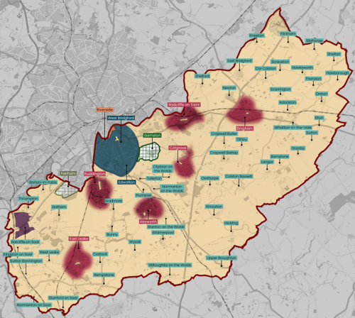
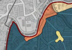
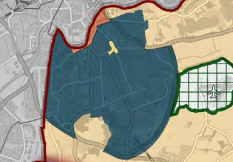
Key
Urban = dark blue
High streets = light green (within Bingham, Cotgrave, East Leake, Keyworth, Radcliffe on Trent, Ruddington and West Bridgford)
Riverside = orange
Key settlements = dark red
Fairham - Site Specific Design Code = light green hatched
Gamston - Site Specific Design Code = dark green hatched
Local Development Order (LDO) - Site Specific Design Code = purple
Rural = cream
A site specific design code has, or is being developed, for the two strategic allocations. These site specific design codes will be the only code applied to the strategic allocations. The site specific design codes contain a comprehensive development framework for the two strategic allocations, providing guidance for the preparation and determination of planning applications for the strategic allocations and to ensure the co-ordination of key infrastructure.
As part of the Local Development Order for the Ratcliffe on Soar Power Station, a site specific Design Guide was produced and approved. The Design Guide sets out the key design principles which applicants will need to demonstrate following as part of an application for a certificate of compliance under the Local Development Order. The Design Code will not apply to the Local Development Order for the Ratcliffe on Soar Power Station.
Area Type Geographies
The area covered by each of the area types are describe in more detail at Appendix 3.
If you are unsure which area type applies to your planning application, you should check with the Borough Council’s Planning and Growth team.
How to use the design code
The design code is a set of rules that describe what must or must not be included as part of a planning application. The design code is collated at Appendix 1 and as a downloadable table. Depending upon application type and scale, the table can be filtered to clearly set out which codes are relevant to your application.
Applicants are required to submit as part of a planning application a compliance statement to demonstrate their compliance or non-compliance with the design code. The submission of a compliance statement will form part of the validation requirements to register a planning application.
The codes are structured around eight key topics, each supported by a detailed ‘design note’. These are:
- 0. Planning and Design Processes
- 1. Street Hierarchy and Servicing
- 2. Infill and Intensification
- 3. Multi-dwelling and taller buildings
- 4. Landscape
- 5. Householder
- 6. Rural
- 7. High Streets and Retail
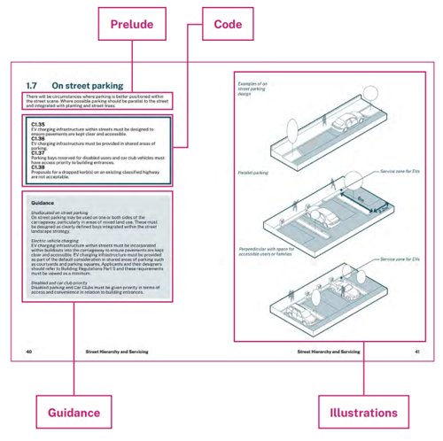
Each design note is divided into sub-topics. A typical page may include the following:
- A prelude: why is this subject important.
- Code: what are the rules – the musts and must nots.
- Guidance: promoting good design practice, they set out the should and should nots.
- Illustrations or case studies: demonstrating how to apply code or guidance and presenting examples of UK wide good practice. All visuals are indicative, offering an example of how the code or guidance might be implemented.
- Further supporting information: where topics are more complex or require situating, further detail is provided.
0. Planning and Design Process
When to apply this design note
Experience has shown that when applicants and their design teams follow a robust planning and design process design quality is understood at planning stages and can be upheld after permission has been granted.
Planning applications, including Section 73 applications, will not be recommended for approval unless they can demonstrate how they have followed the Planning and Design Process design note and meet the relevant requirements of the Design Code.
Proposals for major applications must be accompanied by a Design and Access Statement (DAS) that includes a detailed account of how the proposal has been developed following each of the nine stages of the Planning and Design Process design note.
Minor applications are not required to follow the Planning and Design Process design note but are advised to consult the document and use it as a best practice guide.
Purpose
To help speed up the planning process and improve the quality of design in Rushcliffe.
Following these nine stages will help applicants and their design teams to adopt good design principles and practices.
It outlines the planning and design process and considerations that will help to deliver high quality new development in Rushcliffe.
1. Context
During this first stage applicants should undertake research and fieldwork to develop their understanding of the role of the application site in its wider context through:
- Its history.
- Any cultural aspects, the importance of the place to local people and the social networks of the area.
- Its role as part of the economic landscape.
- Its role as part of the larger natural ecosystem and climate, and the wider Blue and Green Infrastructure network.
- The wider movement networks.
- Historic environment and the need to consider the significance of any heritage assets, including their setting.
Preparation
Understanding the context and setting
(RIBA 0 - 2)
- Context
- Stakeholders
- Benchmarking
- Site Appraisal
- Sustainable Baseline
Design Scheme
Applying the understanding gained to design a proposal
(RIBA 2 - 4)
- Concept Design
- Review
Planning Application
Building Regulations and Planning Conditions
(RIBA 4/5 +)
- Submission
- Additional Detail
2. Stakeholders
Applicants should identify who the relevant stakeholders are and plan how and when they will engage with them.
Local stakeholders may include residents, local businesses, not-for-profit organisations, schools, religious groups, other prominent
informal networks such as local heritage groups, sports clubs, parenting groups etc.
Authorities may include the Local Planning Authority (LPA), Parish Councils, Highway Authority, Utility providers, Emergency Services, Severn Trent Water, Internal Drainage Board, Environment Agency and other relevant organisations.
Applicants should decide whether to seek formal pre-application advice from the Local Planning Authority before moving forward to stage 3.
3. Benchmarking (design quality)
For residential proposals, applicants should use a tool to help appraise design quality and use this to form the basis of pre-application discussions with stakeholders.
It is recommended that applicants use Building for a Healthy Life (BHL). Where an applicant chooses not to use BHL they may use an alternative approach but should make the reasons for this explicit in the DAS and if unsure consult the LPA beforehand.
Building for a Healthy Life is recommended on the grounds it has been created to allow a broad range of people to use it easily – from members of a local community, local councillors, developers to local authorities – allowing those involved in a proposed new development to focus their thoughts, discussions and efforts on the things that matter most when creating good places to live.
Applicants should use BHL to think about the qualities of successful places and how these can be best applied to their proposed development in its wider context.
4. Site appraisal
The characteristics of a site will influence the layout and form of development. The response to those characteristics will significantly determine the distinctiveness of the design.
Site appraisals should be primarily map based using a number of topic-based ‘overlays’ where the appraisal is likely to be complex.
The analysis must include as a minimum, or justify where it does not include:
- Landscape and topography.
- Site micro-climate.
- Site ecology.
- Existing site conditions.
- Infrastructure.
- On and off-site movement network.
- On and off-site open space network.
- Opportunities and constraints.
- Heritage - above and below ground.
- Setting of a heritage asset where applicable.
- Green Belt.
Landscape and topography: the three-dimensional aspects of the site are likely to exert as much influence on the character of any
development proposal as its two-dimensional form.
Site micro-climate: watercourses, flood risk, drainage, gradients, exposure to wind, sun path, sunny slopes and shady slopes.
Site ecology: habitat and biodiversity characteristics of the site, designations and protections, mature trees, Tree Preservation Orders (TPO), hedgerow and ponds.
Existing site conditions: ground conditions, site boundaries, points of access, existing buildings and other structures on-site.
Infrastructure: utilities, nearby uses and facilities such as schools, heath care, shops etc.
On and off-site movement network: existing walking and cycling routes, public transport infrastructure, local street networks/hierarchies.
On and off-site open space network: green corridors, woodland, nature reserves, formal parks, squares, play areas, greens, sports fields etc.
Opportunities and constraints: summarising all the above positive factors in the area which gives the site an identity and character and identifying any negative aspects that development of the site could potentially improve.
5. Sustainable Baseline
The National Design Guide sets out an energy hierarchy for reducing the carbon cost of new buildings. It is based upon three principles:
- Reducing energy demand, both in construction and in use.
- Using energy-efficient systems within buildings.
- Maximising renewable energy sources, especially on-site generation, and community-led initiatives.
Applicants must complete the checklist in Appendix 1 of the Rushcliffe Low Carbon and Sustainable Design SPD and reference this in the DAS.
This stage will have implications for the proposed design as it may influence fabric-first decisions regarding building form, orientation, materials, procurement and on-site renewable energy sources.
Low carbon and sustainable design principles should influence design development from the outset.
Pre-determined site layouts and forms of development can rarely be retrofitted to achieve the same outcomes.
6. Concept design
Concept designs should be recorded on a map/plan, or a series of drawings and preferably supported by 3D illustrative sketches and annotations.
A concept design is not a detailed layout, but it must show the most important aspects of the proposed development such as the basic design decisions about the function, appearance, and layout of the proposed development.
Proposals of over 50 dwellings should provide a concept masterplan indicating delivery phases.
By stage 6 applicants should be able to answer the following questions:
- What will be the character of the development?
- How will the opportunities and constraints identified during the site appraisal be resolved?
- For residential development, how is the design approach responding positively to the 12 considerations of BHL?
- How is the design approach responding positively to input from the community and other stakeholders?
At this stage the applicant should also be able to answer questions about the intended approach to the following design considerations:
- What is the approach to accessing the development?
- What is the approach to prioritising walking and cycling?
- How will the development address the site boundaries and look out on adjacent land and development?
- How will the existing site ecology, structures or buildings influence the layout and form of the proposals?
- How will the development be given identity and be legible?
- What is the site wide approach to:
- Green and blue infrastructure
- Location and function of open spaces
- Sustainable drainage verges
- Tree planting
- Play spaces
- Allotments
- Foot/cycle-paths and cycle storage
- Bin storage and collection points
- Heritage assets and their setting
- How will biodiversity net gain be delivered within the site?
- What is the approach for reducing the carbon cost of the development?
- What is the approach to ensuring vehicle circulation and parking will not dominate the character of the development?
At this stage the applicant should summarise stages 1-6 with supporting plans, drawings and photographs and this information can be used in the DAS.
Applicants that choose to progress beyond stage 6 without seeking pre-application advice from the LPA are at greater risk of failing to comply with this Planning and Design Process design note and the Rushcliffe Design Code.
7. Design Review
Applicants and their design teams should now conduct a review of their design development thus far and discuss with the LPA whether a formal Design Review, using Design Midlands or another agreed forum, is appropriate.
Having conducted an appropriate review, applicants and their design teams should now produce a more developed proposal based on the analysis and evidence produced to date.
A draft DAS should accompany the developed design and explain the evolution of the proposal through stages 1 to 7 of the Planning and Design Process design note.
8. Submission
In addition to satisfying all validation requirements, Full and Reserved Matters applications are expected to submit as a minimum the following to ensure design quality can be accurately appraised and determined:
- Sections through the site and street elevations along the main frontage(s).
- Siteplans giving accurate location of trees, hedges, other landscape features, all other relevant structures, all adjacent buildings, bus stops and bus routes.
- Coloured and annotated elevational drawings providing details of all building materials and finishes.
- Drawings showing details of boundary design, lighting, and street path materials.
- 3D visuals.
- Labelling of LEAPS and LAPS (Local Equipped Areas of Play and Local Areas of Play).
9. Additional detail
Some details can be provided after the granting of planning permission and will be secured through planning conditions attached to the planning permission. This could include final specification, environmental issues, circular economy, end-of-life disposal, or arrangements during construction such as phasing.
C0.1
Proposals for major applications must be accompanied by a Design and Access Statement that includes a detailed account of how the proposal has been developed following each of the nine stages of the Planning and Design Process design note.
Masterplanning
Producing a masterplan for a site can be an effective way of creating a successful development and navigating the planning and design process. This is because the masterplanning process can help to clarify policy and design expectations, set a clear vision for a site, inform infrastructure decisions and viability assessments, and identify requirements for developer contributions early in the planning
process.
What is a masterplan?
A masterplan sets the vision and implementation strategy for a site focusing on site-specific proposals such as landscaping, layout and mix of uses, transport and movement, scale, massing and grain of development. A masterplan is often accompanied by a range of supporting evidence such as a local character study or landscape assessment. If a development is to be delivered in several phases, an implementation strategy should also be included.
Masterplans and Design Codes
Any masterplan being prepared for a site within Rushcliffe is expected to demonstrate how the mandatory requirements and further guidance within the Rushcliffe Design Code can be implemented through the site-wide design proposal. In some cases, it may also be necessary to set out how more detailed design requirements are being met in a separate site-specific design code which can accompany or follow the overall Masterplan.
Masterplans for development sites can be produced by the landowner/ developer on their own, or in partnership with the local planning authority. In all instances the masterplanning process should be collaborative and multidisciplinary and subject to a separate community and stakeholder engagement exercise so that site opportunities and constraints are understood early on.
Care should be taken to ensure that masterplans are viable and understood by all stakeholders and include accurate representations of what the proposed development will look like. They must not be misleading to the public.
The level of detail included in a masterplan may vary depending on the complexity of the site. The National Model Design Code section 2.c Masterplanning includes guidance on what a notional masterplan is likely to include.
1. Street Hierarchy and Servicing
When to apply this design note
This design note is required to be followed when a development proposes the creation of a new street or multiple new streets.
The term ‘street’ will be applied at the discretion of the LPA to all routes providing access, vehicular or otherwise, that connects to, through and out of new residential and mixed-use development.
All new development involving the creation of a single or multiple new streets must apply the Rushcliffe Street Hierarchy. This hierarchy includes three street types, each with varying spatial characteristics that reflect their role and function in the hierarchy.
Pre-application
It is recommended during the pre-application stages that applicants discuss and agree in writing with both the LPA and Highways Authority a proposed street hierarchy indicating street types for each new street being proposed.
This requirement covers all proposals ranging from the creation of a single street to a network of multiple new streets. The overall design of each proposed street must conform to the design parameters for the corresponding street type, set out at 1.2 Tertiary Streets, 1.3 Secondary Streets and 1.4 Main Streets of this design note.
It is anticipated that not all proposals will contain each street type.
The Rushcliffe Street Hierarchy has been designed in consultation with Nottinghamshire County Council Highways Authority. Applicants must engage early with Nottinghamshire County Council and Borough Council Officers to explore adoptable street designs and any proposed variations from the Nottinghamshire County Council Highway Design Guide, which all applicants should refer to when proposing the creation of new streets.
Rushcliffe Borough Council require applicants and their designers to agree the general geometry of residential streets in consultation with the Highway Authority.
This design note follows the principles and guidance in Streets For A Healthy Life and applicants and their designers should consider this and other relevant design guidance including Manual for Streets I and II and Building for a Healthy Life.
1.1 Street hierarchies
C1.1
The spatial characteristics of different street types must be distinctive from one another.
C1.2
Streets proposed as part of new development must be designed with traffic-calming measures.
Guidance
When considering the character of a new development it is common to consider creating a range of different house types, scales, materials and densities. But it is equally important to create a sense of character through a variety of streets and spaces. The spatial characteristics of different street types must be distinctive from one another. Distinction can be in the form of enclosure ratio, carriageway width, land use, landscaping, and parking.
Streets proposed as part of a new development should be designed for vehicles speeds of 20mph or lower and should be designed to give pedestrians priority over vehicle users.
A hierarchy comprises a network of streets and spaces progressing from the entry (or entries) to the development site progressing down to the most minor streets and courtyards.
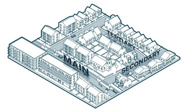
Rushcliffe Street Hierarchy
Tertiary: Quietest residential streets with lower levels of traffic. Often Homezone principles apply.
Secondary: The most common residential street. Non-residential uses can be present.
Main: Entry (or entries) to a development. Main public transport, vehicular and cycle routes
The Rushcliffe Street Hierarchy is intentionally inverted to put the emphasis on the requirement to create streets that give people priority over vehicles, and which are safe and attractive to all users.
1.2 Tertiary streets
These quieter streets are designed for people first and are not normally bus routes. A tertiary street can have clear, designated footpaths or can be designed to Homezone principles with a level surface. Cyclists will share the main street surface with vehicles.
Traditionally this street type might include Mews, Courts, Yards, Lanes, Closes and Cul-de-sacs. Tertiary Streets are quieter residential streets. They can be connected at both ends of the street, or provide no through routes for vehicles (e.g. cul-de-sac).
C1.3
Street lighting must be present on all new tertiary streets.
C1.4
New tertiary streets must have at least one pedestrian priority feature to help encourage slower traffic speeds every 40 metres, or at least one feature where a street is less than 40 metres in length.
C1.5
On-street parking on tertiary streets must be designed as clearly defined parallel and/or chevron bays that are integrated within the street landscape strategy.
C1.6
Verges and planting areas that contain street trees must be at least 2 metres wide on tertiary streets.
Guidance
Enclosure ratio
Buildings are usually situated on both sides of tertiary streets giving a strong sense of enclosure to create a residential character and positive pedestrian and cycling environment. In some contexts a tertiary street can feel comfortable where the width of the space is less than the height of the buildings on either side.
Setbacks
Buildings may be set back by between 0.5 and 3 metres to provide a threshold or front garden. This may also accommodate a bin store, cycle store and a low boundary wall, railing or fence.
Space for walking and wheeling
Tertiary streets may have a level surface, but this does not preclude footpaths. Surface materials should be suitable for use by disabled people, avoiding patterns that may create visual confusion and potential hazards for visually impaired users.
Cycling on the carriageway will normally be acceptable – see LTN 1/20 for further guidance.
Pedestrian priority interventions
Tertiary street design must incorporate traffic calming features to encourage slower traffic speeds. These features reinforce pedestrian priority by intentionally forcing vehicles and cyclists to slow down to walking speeds and/or come to a halt.
Vehicle speed
Tertiary streets should be designed for 20 mph or less, or 15 mph for shared surfaces.
In curtilage parking
Vehicular access to plots is permitted from a tertiary street, but parking to the front of the building line is discouraged and should not dominate streets.
On street parking
Can be provided, but not allocated. It is recommended that provision is made for one parking space per three dwellings.
Parking proposed on either side of a street should be staggered and not directly opposite.
Service strips
To be a minimum width of 1 metre and should not read as a narrow footway.
Tertiary street design will not be permitted where:
- A lack of space to park vehicles is likely to result in pavement parking.
- The street is not part of a connected network for walking and cycling.
- ‘Segregation sandwiching’ occurs.
- There is a lack of differentiation between the surface of the street and the adjacent on street parking bays.
- Planting strips are too narrow and will be difficult to maintain.
residents and pedestrians in tertiary streets and secondary streets in
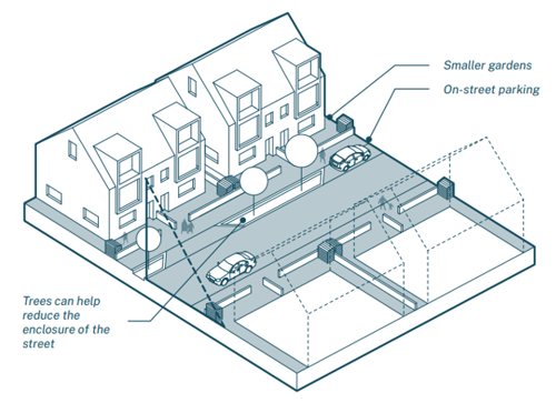
urban contexts.
- On-street parking
- Smaller gardens
- Trees can help reduce the enclosure of the street
play and linear park (Photograph by Rebecca Clark)
speeds. Varied planting creates a buffer between houses
and street, whilst clear visibility of entrances and front
windows help animate the street.
(Photograph by Rob Beardsworth)
different takes on the conventional residential street.
Building line gives continuity and a strong sense of
enclosure. Pedestrian priority intervention using a planting
area that intentionally narrows the street to disrupt
vehicle continuity. An example of how 3-storey house
types can enable a wider street section compromising the
sense of enclosure. Here the additional street width allows
for the relatively deep liner park alongside the vehicle
path and footpath. Note pedestrians feel safe and
comfortable to walk in the vehicle path.
(Photographs by Rebecca Clark)
1.3 Secondary streets
The most common form of residential street. Secondary streets usually provide a link between main streets and form a network to tertiary streets and spaces.
Designed for 20 mph or less, secondary streets are people-orientated residential streets much like their tertiary street counterparts. They differ in that some non-residential uses such as cafes, community and retail space may be present and traffic volumes are slightly higher. They can also be good secondary locations for larger community facilities such as schools and health centres.
These streets typically have a clear distinction between vehicular and pedestrian space, with defined kerbs and footways. Secondary streets are not usually bus routes and cycling in the carriageway will normally be acceptable.
C1.7
Street lighting must be present on all new secondary streets.
C1.8
On secondary streets, pedestrian crossovers located across the mouth of side street junctions must maintain the trajectory of the footpath (desire lines).
C1.9
New secondary streets must have at least one pedestrian priority feature to help encourage slower traffic speeds every 50 metres, or
at least one feature where a street is less than 50 metres in length.
C1.10
Level footways must be maintained across driveway access points on secondary streets.
C1.11
On-street parking on secondary streets must be integrated within the street landscape strategy.
C1.12
New secondary streets must integrate areas of soft landscaping, including SuDS and tree planting, into the design of the street.
C1.13
Verges and planting areas that contain street trees must be at least 2 metres wide on secondary streets.
Bicycles and vehicles share the carriageway. Absence of frontage parking creates a sense of enclosure which will strengthen as street trees mature. Verges on both sides are designed as SuDS and segregate footpaths. Street lighting and lack of crossovers onto driveways add to a safe and convenient pedestrian environment.
Other features of interest include the use of timber posts to prevent parking on the verge (always consult Highways Authority as such features could be deemed as a maintenance issue).

Tree lined verges on one side of the street creates secondary enclosure and parallel parking bays on the other side of the street help maintain the sense of enclosure (perpendicular bays would increase street width). Bays are interspersed with street trees to break up the visual dominance of parked cars.
Other features of note include how street lighting and lack of crossovers onto driveways add to a safe and convenient pedestrian environment.
Guidance
Enclosure ratio
Can vary according to the adjacent land uses and local context. In an urban area secondary streets can feel comfortable where the width of the street is only a little wider than the height of the buildings. In suburban settings the width of the street can be at least twice that of the building height, allowing more space for conventional footpaths, verges, street trees and on street parking.
Setbacks
Buildings may be set back by between 0.5 and 6 metres to provide a threshold or front garden. This may also accommodate a bin store, cycle store, a low boundary wall, railing or fence. Principal elevations and front doors should face the street with frontage access for all buildings.
Space for walking and wheeling
In most cases, secondary streets will have at least 2 metre wide footpaths on both sides of the carriageway, that are unobstructed for pedestrians. Pedestrian crossovers with dropped kerbs located across the mouth of side street junctions must maintain the trajectory of the footpath (desire lines) and not deviate further down the side street.
Cycling on the carriageway will normally be acceptable – see LTN 1/20 for further guidance. Street lighting must be present.
Pedestrian priority interventions
Secondary street design must incorporate traffic calming features to encourage slower traffic speeds. These features reinforce pedestrian priority by intentionally forcing vehicles and cyclists to slow down to walking speeds and/or come to a halt.
Vehicle speed
Secondary streets should be designed for 20 mph or less.
In curtilage parking
Where curtilage parking is provided at the front of dwellings level footways must be maintained across driveway access points.
On street parking
Can be provided, but not allocated, on one or both sides of the carriageway. It is recommended that provision is made for one parking space per three dwellings. In streets of mixed land use a higher ratio may be acceptable by agreement.
On street parking must be designed as clearly defined bays integrated within the street landscape strategy.
Service strips
To be a minimum width of 1.5 metres and should not read as a narrow footway.
Secondary street design will not be permitted where:
- A lack of space to park vehicles is likely to result in footway parking.
- Tandem parking is proposed.
- Street is not part of a connected network for walking and cycling.
- ‘Segregation sandwiching’ occurs.
- Lack of differentiation between the surface of the street and adjacent on street parking bays.
- SuDS are absent.
- Planting strips are too narrow and will be difficult to maintain.
- Footways undulate due to multiple driveway access points.
- Backs or sides of properties on to street create a deadening effect to the street.
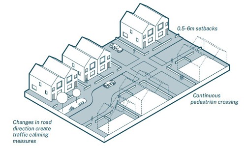
Illustrative secondary street designed for low speeds incorporating examples pedestrian priority measures.
- Changes in road direction create traffic calming measures
- 0.5 - 0.6 metre setbacks
- Continuous pedestrian crossing
1.4 Main streets
Sometimes also referred to as primary streets, main streets are the strategic routes for vehicular traffic through a development but must also be designed to balance this function with the needs and safety of all users. Not all new developments are required to contain a main street.
C1.14
Main streets must be designed with a clear distinction between vehicular, cycle and pedestrian space.
C1.15
Protected space for cycling must be provided on all new main streets.
C1.16
A main street must not solely provide access to residential uses.
C1.17
Main streets must be designed to accommodate public transport.
C1.18
Street lighting must be present on all new main streets.
C1.19
Pedestrian crossovers with dropped kerbs located across the mouth of side street junctions must maintain the trajectory of the footpath (desire lines) on all new main streets.
C1.20
New main streets must have at least one pedestrian priority feature to help encourage slower traffic speeds every 60 metres.
C1.21
Level footways must be maintained across driveway access points on new main streets.
C1.22
On-street parking on main streets must be designed as clearly defined parallel and/or chevron bays integrated within the street landscape strategy.
C1.23
New main streets must integrate areas of soft landscaping, including SuDS and tree planting, into the design of the street.
C1.24
Verges and planting areas that contain street trees must be at least 2 metres wide on main streets.
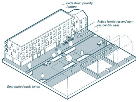
- Active frontages and nonresidential uses
- Pedestrian priority feature
- Segregated cycle lanes
Guidance
Main Streets
Main streets must be designed with a clear distinction between vehicular, cycle and pedestrian space and can vary in their design according to the specific context and function.
Protected space for cycling must be provided – see LTN 1/20 for further guidance.
A main street must provide direct access to a mix of land uses. Where it is only providing access to residential development the street must be designed as either a secondary or tertiary.
A main street must provide direct access to a mix of land uses. Where it is only providing access to residential development the street must be designed as either a secondary or tertiary.
A main street can vary in character along its length according to the adjacent land uses and townscape character. An important design distinction to make is that a main street is not a character area itself. A main street will pass through different character areas, or
neighbourhoods, and will take on the characteristics of that locality.
The National Model Design Code stipulates that main streets may vary and take on the character of an avenue, boulevard or parkway, especially in larger schemes.
Parkways
Streets with a wide central natural grass reservation with trees, along with carriageways and pavements. These can be suitable for new suburban development in Rushcliffe.
Boulevards
Streets with a central carriageway with secondary one-way streets for access and parking with trees planted in the reservations. Less appropriate for certain area types in Rushcliffe.
Avenues
Streets with a central carriageway and wide tree-lined verges either side. Can be suitable for both urban and suburban settings within Rushcliffe.
Public transport
Main streets must be designed to accommodate public transport, allowing for the integration of bus stops, even if no bus service is planned in the short term.
Space for walking and wheeling
Main streets should have footways that are at least 2 metres wide on both sides of the street, that are unobstructed for pedestrians, and include crossings where necessary. Street furniture should be provided as land uses dictate.
Pedestrian priority interventions
Main streets will tend to have straighter alignments, and therefore designers must use pedestrian priority features to help encourage slower traffic speeds at least every 60 metres. These features must reinforce pedestrian priority by intentionally forcing vehicles and cyclists to slow down to walking speeds and/or come to a halt.
Vehicle speed
Main streets should be designed for 20 mph or less.
In curtilage parking
Where curtilage parking is provided at the front of dwellings level footways must be maintained across driveway access points.
On street parking
Defined car parking bays may be used on one or both sides of the carriageway that are integrated within the street landscape strategy.
Service Strips
To be a minimum width of 2 metres and should not read as a narrow footway.
Landscaping
Street trees and SuDS are an important feature and must be present and integrated within main streets.
Main (primary) street design will not be permitted where:
- There is insufficient protected cycle infrastructure.
- A lack of space to park vehicles is likely to result in parking on footpaths.
- Lack of differentiation between the surface of the street and adjacent on street parking bays.
- SuDS are absent.
- Planting strips are too narrow and will be difficult to maintain.
- Footways undulate due to multiple driveway access points.
- Backs or sides of properties on to street create a deadening effect to the street.
1.5 Designated parking
As car ownership continues to increase, parking is now a significant design issue across Rushcliffe. It can be an emotive issue leading to disputes between neighbours, missed bin collections and a contentious design issue leading to planning refusals.
Parking needs to be designed carefully, and parking capacity needs to be flexible. What works on one site, may not work on another. Where and how vehicles are parked has a massive impact on how a place looks, feels and functions. There needs to be a balance between achieving sufficient parking without it being over-dominant and detrimental to other aspects of good design
C1.25
In-curtilage parking located in front of the main building line must be integrated with an area of soft landscape that is equal to or greater than the size of the parking area.
C1.26
All parking spaces must have permeable surfaces or be connected to a sustainable urban drainage system.
C1.27
Carports must be offset by 1 metre from the highway and garages must be offset by 5.5 metres from the highway and be of sufficient dimensions to allow for the primary purpose of parking a vehicle.
Guidance
Parking principles
Tandem parking arrangements result in displaced car parking which leads to the obstruction of highways and prevent refuse collections. Where space is left in curtilage outside homes for the possibility of tandem parking, the highways authority will not usually count the additional parking space towards agreed parking provision.
In curtilage parking
Parking within the curtilage of properties is generally better located at the side of the house or partially behind the building line as opposed to entirely to the front. Tandem parking will generally not be counted as two spaces.
Where parking is located at the front of a property it must be integrated with soft landscaping, preferably equal to or greater than the size of the parking area. Landscaping should be arranged in such a way that it is not easily converted into another parking space.
1.6 Shared parking areas
A move towards collective parking strategies will allow for streets that are not dominated by parked vehicles and maximise opportunities for soft landscaping and amenity spaces which bring social and environmental benefits and may also allow for more efficient land uses.
C1.28
Access to rear parking courtyards must have headroom for resident owned trade vehicles to enter.
C1.29
Proposals for private drives must demonstrate why an adopted tertiary street cannot be used instead.
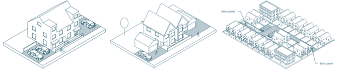
C1.30
Private drives must not serve more than 5 dwellings.
C1.31
All private drives must have an entry point via a crossover maintaining pedestrian and cycle priority and have a dwelling terminating the view in.
C1.32
In parking squares, bays must be arranged in clusters of up to 5 and integrated with areas of soft landscaping.
C1.33
Rear parking courtyards must be directly overlooked by homes, with street lighting present.
C1.34
Neighbourhood-scale parking squares must be enclosed by local facilities on at least three sides (exceptions may be deemed acceptable – see guidance note).
Guidance
Rear courtyards
To be used sparingly. Poorly designed rear parking courtyards are often under-used by residents, leading to displaced parking in streets. Rear parking courtyards should be small in scale and must be directly overlooked by homes, with street lighting present. In rear spaces, parking bays should be arranged in clusters of 4 or 5 and should be integrated with areas of soft landscaping and tree planting.
Within rear courtyards homezone principles will help pedestrians take precedence over vehicle movements. Surface materials in courtyards should vary from the surface material used for the carriageway. Access to rear parking courtyards must have headroom for resident owned trade vehicles to enter to prevent displaced parking of larger vehicles.
lighting and well-detailed private parking courtyard with bays arranged
in clusters of three.
(Photograph by Rob Beardsworth).
Shared private drives
Applicants and their designers must justify every private drive being proposed to the LPA and Highway Authority and demonstrate why an adopted tertiary street cannot be used instead. Dead-end shared drives should have a shared surface and turning areas so that all vehicles, including delivery vehicles, can egress in forward gear.
Parking squares
Also known as front courtyards. These are areas devoted to residential parking, allocated or not, enclosed by surrounding houses. Parking squares can provide additional spaces for other nearby houses and visitors. The optimum number of spaces will depend on the layout, types and density of housing proposed, but could be based on the number of homes within a 50 metre radius of the square with additional spaces for visitors and deliveries. Parking squares should also provide secure cycle parking and some seating is recommended.
Neighbourhood parking squares
Suitable only in larger developments. Neighbourhood-scale parking squares must be enclosed by local facilities on at least three sides. Exceptions to this may be where a parking square is associated with public open space or outdoor facilities in which case less enclosure may be deemed acceptable.
Car parking provision is intended for users of the facilities such as shops, childcare, health and other community uses. The optimum number of spaces would depend on land uses but is likely to be between 30 and 50 spaces.
Bin collection
As refuse vehicles are only able to access adopted highways, suitable bin collection points should be provided for any dwellings served by private drives with collection points adjacent to the public highway. The expectation will be for residents to place their bins at such collection points prior to collection and remove bins after emptying.
Servicing
It is important to ensure streets and public spaces are designed with management and maintenance in mind (this is dealt with further at Section 4.7 of the Landscape Design Note). Even a well-designed space will end up having a negative impact on the environment and local community if it is not appropriately maintained in a discreet and proportionate manner
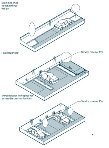
1.7 On street parking
There will be circumstances where parking is better positioned within the street scene. Where possible parking should be parallel to the street and integrated with planting and street trees.
C1.35
All agreed provision of EV charging infrastructure within streets must be designed to ensure pavements are kept clear and accessible.
C1.36
EV charging infrastructure must be provided in shared areas of parking. Level of provision to be agreed with Local Planning Authority and Local Highways Authority.
C1.37
Parking bays reserved for disabled users and car club vehicles must have access priority to building entrances.
Guidance
Unallocated on street parking
On street parking may be used on one or both sides of the carriageway, particularly in areas of mixed land use. On street parking must be designed as clearly defined bays integrated within the street landscape strategy.
Electric vehicle charging
EV charging infrastructure within streets must be incorporated within buildouts into the carriageway to ensure pavements are kept clear and accessible. EV charging infrastructure must be the default consideration in shared areas of parking such as courtyards and parking squares. Applicants and their designers should refer to Building Regulations Part S and these requirements must be viewed as a minimum.
Disabled and car club priority
Disabled parking and Car Clubs must be given priority in terms of access and convenience in relation to building entrances.
1.8 Cycle storage
New developments should make it more attractive for people to choose to walk or cycle for short trips helping to improve levels of physical activity, and reduce the impact of car use on air quality and local congestion.
C1.38
All new dwellings must be purposely designed with an adequately sized and secure space for the storage of at least one adult sized
bicycle.
Guidance
Communal storage
A common solution for groups of smaller properties or apartment buildings is to provide communal cycle parking facilities for residents only. These should be secure and located on the ground floor. Outdoor cycle storage should be weather-proof and located in well-overlooked and well-lit locations. Cycle storage solutions must take account of the need for at least a 2 metre circulation space. Stacked storage may provide a solution.
Visitor cycle storage
Publicly accessible cycle parking for visitors is needed in convenient locations close to the entrances to homes, shops and other facilities. It should also be included in all publicly accessible shared parking areas such as residential and neighbourhood parking squares. Whilst visitor cycle storage may differ from that provided for residents, it must always provide sited and secure undercover cycle parking, with overlooked facilities that are positioned close to entrances to buildings.
Location
Cycle storage should be easily accessible and located close to entrances to make the choice to cycle convenient and desirable to move around the neighbourhood or access local services.
Biodiversity
On-street cycle storage is a great opportunity to enhance biodiversity through green roofs or insect habitats.
1.9 Recycling and waste storage
Most properties in Rushcliffe now have at least three wheelie bins. Often the most convenient and practical storage point is at the front of properties but it is important to avoid bins being left out in haphazard and unsightly ways. Convenient and practical storage solutions need to be integrated sensitively and screened from view. Other design considerations should enable the flow of air and avoid building entrances becoming cluttered.
C1.39
Proposals for new properties or use of land must clearly set out waste collection strategies.
C1.40
Bin storage must be enclosed to provide a positive outlook for residents and designed to be robust, secure and ventilated.
Guidance
Proposals for new properties or use of land must clearly set out waste collection strategies. Sometimes a combination of different strategies may be appropriate across larger sites and different housing type and tenure groups. For example, whilst housing in rural and suburban areas may be expected to accommodate bin storage and collection solutions on plot, apartments and medium-density housing in urban areas may suit collective, not individual, strategies
Bin storage solutions must be enclosed to provide a positive outlook for residents and designed to be robust, secure and ventilated. Applicants and their designers should also consider fire compartmentalisation, cleaning and maintenance, and efficiency through internal rotation of bins via a management strategy.
Designing bins stores to share an architectural style with the main buildings on a site will maintain the quality of the development. Off-the-shelf retrofitted solutions are often visually intrusive, inconvenient or have a short design life.
Biodiversity
Communal bin stores should integrate green roofs and insect habitats to support biodiversity.
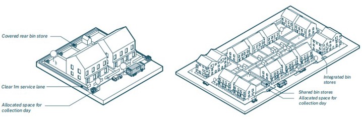
Left - Individual
- Covered rear bin store
- Clear 1 metre service lane
- Allocation space for collection day
Right - Collective
- Integrated bin stores
- Shared bin stores
- Allocated space for collection day
2. Infill and Intensification
When to apply this design note
Infill and intensification development takes place within an existing built-up area. It can be on a small-scale such as the development of a gap site within an existing street frontage, or on a larger scale. For example where a proposed change of land use or demolition(s) results in new development opportunities.
This type of development is usually on brownfield land (previously developed land) and usually viewed positively due to being inherently more sustainable than expansion into greenfield sites.
The priority when designing for infill and intensification is to be a good neighbour to surrounding buildings and uses.
2.1 Area type (local character)
The NPPF, National Design Guide and Rushcliffe Borough Local Plan requires new development to respond to the distinctiveness and character of the existing built and natural environment.
C2.1
Proposals must have regard to:
- The relevant Area Type vision, and
- Area Type worksheets in the design code Baseline Appraisal taking into account development pattern of the local area ,such as building lines, plot structure and grain.
Guidance
The scale, proportions and grain of new development should make efficient use of the land available, whilst having regard to surrounding development and the Area Type visions. As infill and intensification occurs the overall scale of development should be appropriate to each area type. For example, urban forms of development will be inappropriate in rural or village settings and suburban forms of development will be inappropriate in compact urban areas of West Bridgford and Trent Riverside.
Successful design approaches rarely copy what’s already there but rather take inspiration from it. Applicants and their designers are encouraged to observe, absorb, and reinterpret local context and character by analysing the local vernacular of a site. Understanding what local features are of importance to the local character and using this understanding to inform the design of new development.
2.2 Development pattern and grain
In addition to the overall scale and visual impact of new development, applicants and their designers must demonstrate that their design solution is derived from and responds positively to the prevailing pattern and grain of development found locally.

New development proposed across the borough will need to consider how proposals respond to the prevailing pattern of development. Of particular relevance is the configuration of streets, plots, how building lines address the street, and the location of key open spaces in relation to buildings and groups of buildings.
Guidance
Building lines and the plot structure of a settlement contribute to the overall character of the area and new development must take this into consideration. Block arrangements are more likely to be found in the riverside and older parts of West Bridgford and the key settlements. Curved streets and spacious plots with large gardens are more commonly associated with the detached and semi-detached suburbs of post-war development. Irregular patterns of development can be found in the historic cores of the borough’s key settlements and in a majority of villages.
There are three main types of villages found in Rushcliffe. These are dispersed, linear and nucleated. Each have distinguishable characteristics in terms of their development pattern as a response to their location and terrain as well as economic and social functions overtime.
Another significant factor in determining local distinctiveness is the rhythm and variety of buildings and plots, or plot structure. This is referred to as grain and it derives from the size, frequency and configuration of plots. A greater frequency of smaller plots is known as fine (or tighter) grain, whereas fewer and larger plots is known as coarse (or looser) grain.
New development needs to indicate a proposed plot structure, which together with the way buildings join and relate to the street will have a substantial impact on how it responds to local character and distinctiveness.
Streets found in suburban neighbourhoods, villages and rural areas typically have greater variation in plot structure. Inner urban streets tend to have greater uniformity. For infill development in conservation areas, it is important that historic plot patterns are understood and respected.
Close attention should be given when working in or adjacent to one of the 32 different Conservation Areas in Rushcliffe. Applicants should demonstrate an understanding of the issues from the relevant Conservation Area Appraisals and Management Plans.
2.3 Backland developments
Backland development is considered the development of land that sits behind an established building line of existing housing or other development. This type of development often occurs in areas where principal properties have large rear gardens, such as in parts of West Bridgford, or where urban and suburban blocks have at their centre garages or outbuildings, which are usually reached via a narrow access from the public highway.
The codes relating to backland development would apply where such development is deemed acceptable when assessed against national and local planning policy. There may be sites, for example, where residential development is deemed acceptable but commercial uses would not be acceptable due to amenity issues.
C2.2
The scale and massing of new development in backland sites must not exceed that of surrounding existing buildings.
C2.3
Gates across the entrance routes into backland development will not be permitted.
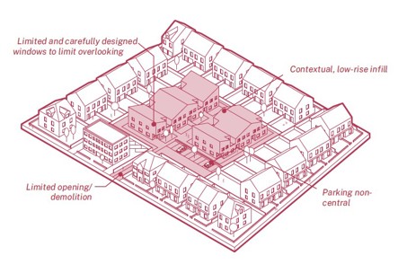
- Contextual, low-rise infill
- Limited and carefully designed windows to limit overlooking
- Limited opening/ demolition
- Parking non-central
Guidance
Where the principle of development is agreed, backland development should be designed from the perspective of bringing forward benefits to adjoining residents, including increased security.
Building scale and massing must not exceed that of surrounding existing buildings. Access arrangements should be proportional to the scale of the development, appropriate to the level of use and must not over-dominate a street.
When designing backland development designers should consider how building line, connected buildings, minimal setbacks, the proportion of the building line occupied by buildings, landscaping, and the orientation of entrances and windows can be used to create a strong sense of enclosure.
It can be difficult to achieve the same level of vehicle access and parking arrangements in backland development compared to the surrounding existing development. In the riverside area type, parts of West Bridgford and the key settlements, lower parking ratios and car-free backland developments may be supported due to the high level of accessibility to the public transport network.
Gates across the entrance routes into backland development will not be permitted as a default position. Design solutions which prevent vehicle ingress, but do not inhibit pedestrian access, are acceptable, providing allowances are made for emergency and other service vehicles to access the site when necessary.
Where views into a backland development are created along new points of access, these sight-lines must be terminated by a building or key group, rather than for example, a gap or minor structure such as a garage or a side elevation.
This may not be the case in rural areas, where views into the countryside may be acceptable.
2.4 Scale of development and building height
Scale is the impression of a building when seen in relation to its surroundings. Scale can also refer to the size of parts of a building or its details, particularly as experienced in relation to the size of a person.
Sometimes it is the total dimensions of a building which give it its sense of scale, and at other times it is the size of the elements and the way they are combined. Sometimes people use the word ‘scale’ simply as a synonym for ‘size’.
This ambiguity means that when discussing the scale of a proposed development it is important that it is made clear what is meant when using the term scale.
Guidance
The impression of the overall scale of an area is influenced by prevailing local building heights, the skyline, key views and the relative prominence of local landmark buildings such as a church spire. What most people regard as the ‘right scale’ of development will fit comfortably within its surroundings. Of paramount importance is how the proposed height and massing of new development responds to the position, mass and height of the surrounding buildings.
Building heights need to consider their surroundings and ensure that they consider the significance of heritage assets and their setting, and do not dominate or diminish the asset or its setting. In all cases of infill development, but especially where new development is seeking to gently intensify local densities, design proposals must ensure access to daylight and sunlight, and safeguard the privacy and outlook for future residents and neighbouring buildings.
The urban and riverside area types have the largest scope to vary from the typical scale of the area. The urban area has a distinct scale, with streets resulting from historic patterns of development, and buildings of a consistent height and character. Along the riverside, the scale of development is generally greater, with opportunities to contrast the scale of new development. Variations in scale can contribute to the creation of attractive and memorable places by making them more legible, the creation of a strong sense of enclosure around public spaces, or through the introduction of landmarks.
In the key settlement and rural area types, the scale of development is typically consistent throughout the areas. New development that contrasts with this scale will be subject to scrutiny.
2.5 Corners
Corners plots are prominent features that require special consideration.
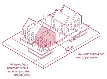
Buildings should respond to their double frontage with windows, entrances and openings onto both street elevations.
- Low walls maintained around perimeter
- Windows from habitable rooms, especially on the ground floor
C2.4
In new development buildings in corner plots must respond to their double frontage with no blank elevations facing a street at ground floor level.
Guidance
Street corners require special consideration. Buildings must respond to their double frontage with windows, entrances and openings onto both street elevations ensuring surveillance of the public realm and avoiding blank elevations facing the street.
Corners may be appropriate locations for taller buildings to help create legibility and identity to street networks. The increased scale should always be appropriate to its context and fully justified.
2.6 Enclosure
The enclosure of a space is influenced by the heights of features on the edge of a space, typically buildings or trees, in relation to the width of a space. Enclosure impacts how people feel when they’re within a space, affecting their sense of comfort, the types and level of activity taking place and the speed which people and vehicles move through a space.
Guidance
Streets with higher levels of enclosure are more common in the centres of settlements where streets and spaces are more people orientated. Levels of enclosure tend to weaken towards the edge of settlements where development tends to be more car orientated.
Townscape enclosure can be formed from perimeter blocks. Whether formal (orthogonal) or informal (irregular), grid structures are an efficient way of dividing space into public fronts and private backs, leading to street-focused layouts.
In the Urban Area and High Street area types, enclosure should support people-focussed streets and spaces. These contexts typically offer greater variation with street networks formed from a pattern of narrow streets and alleys, courtyards and informal squares and larger civic spaces.
Streets and buildings will be less compact as enclosure recedes in the Key Settlements and in the Rural area type. With this lower level of enclosure comes more space and opportunities for landscaping, tree planting and larger gardens.
By arranging the buildings first to form street enclosure (rather than plotting the streets first) designers have a better opportunity to respond positively to local characteristics such as street enclosure, building lines and grain.
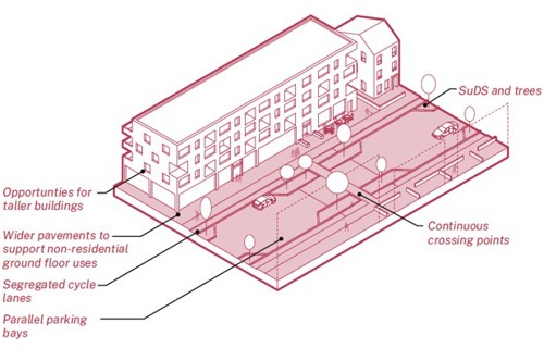
- Continuous crossing points
- Opportunities for taller buildings
- Parallel parking bays
- Segregated cycle lanes
- SuDS and trees
- Wider pavements to support non-residential ground floor uses
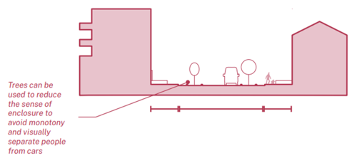
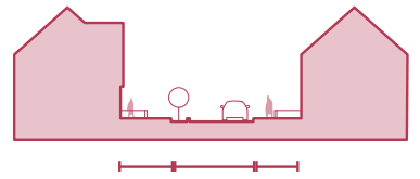
Main street in section - Trees can be used to reduce the sense of
enclosure to avoid monotony and visually separate people from cars
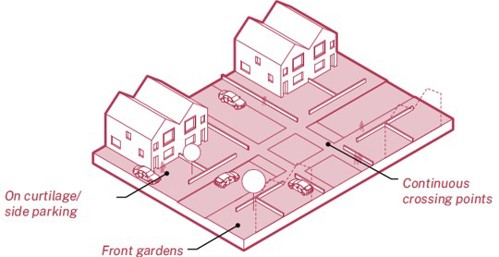
Secondary streets - should be the most common enclosure
- Continuous crossing points
- On curtilage/ side parking
Secondary street - in section
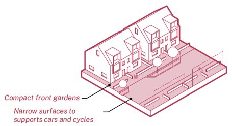
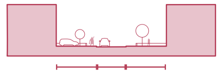
Tertiary streets - should have a tighter sense of enclosure
- Compact front gardens
- Narrow surfaces to supports cars and cycles
Tertiary streets - in section
2.7 Space between homes
The distance between homes has an impact upon privacy and overlooking, loss of light and overshadowing, over-dominance and enclosure.
Guidance
Basic standards including a conventional back-to-back separation of 21 metres for two storey homes are useful reference points but are not mandatory. Strict adherence to these standards will in some instances limit design variety, unnecessarily restrict density and may not reflect local character.
Privacy
Where local context favours non-conventional distances design strategies must mitigate the impact on residents’ privacy and overshadowing. Splayed or offset façades, offset windows and landscaping could be considered.
In most cases, homes will have a more public side (front) and a more private side (rear). Where they do not, designers will need to make use of other design aspects such as internal layouts, window orientation and profile, balconies and other external elements to give residents a sense of control over the privacy of their own home. Where possible, the more private spaces of a home; bedrooms and bathrooms should be located on the more private side of the building
Plot coverage
Will vary according to location and context. In order to prevent sites being over-developed proposals should leave sufficient open space around a new dwelling for outdoor activity and access.
In detached and semi-detached family housing the proportion of plot area to building footprint should generally be greater than 60:40. In terraced housing and other more compact housing types the ratio may be much closer to 50:50 or in some cases with a higher proportion of built footprint to open space.
Private gardens
Private gardens provide important amenity space which supports well-being. Private gardens can also offer other benefits including additional biodiversity and on-site water management. To support this, all front and rear gardens must include at least 50% natural grass, planting and other forms of living vegetation. Rear gardens should be a minimum of 10 metres deep, and should meet the following minimum space standards:
- 1 - 2 bed dwellings - 55 square metres
- 3+ terraced and semi-detached dwellings - 90 square metres
- 3+ bed detached dwellings - 110 square metres
New residential proposals will be expected to meet the above guidelines whilst providing for a variety of garden sizes. Where these guidelines are not met, it should be demonstrated why smaller gardens are acceptable taking into account the overall objectives of the Design Code and planning policy requirements.
The Multi-dwellings and Taller Buildings Design Note addresses the provision of garden space for apartments.
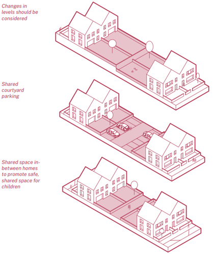
shared courtyard parking and shared space in-between homes
to promote safe, shared pace for children
3. Multi-dwellings and Taller Buildings
When to apply this design note
Rushcliffe has a range of scales (size of buildings) which we have defined by the areas types set out and consulted on in the baseline appraisal. We are setting out two different scales for apartment buildings which are defined as follows:
Multi-dwellings: are defined as two or more dwellings, with a shared entrance(s) and circulation. They may contain apartments across single floors, duplexes or even triplexes.
Multi-dwellings are applicable to the Riverside, Urban and Key Settlement area types.
Taller Buildings: are defined as buildings of 5 storeys and above. They can come in a variety of arrangements and will have shared entrance(s) and circulation. They may result in a significant change to the skyline of Rushcliffe and are subject to further scrutiny.
Taller buildings are applicable to the Riverside area type only.
Process
Apartment buildings can provide a range of benefits as part of new housing options in Rushcliffe.
- Allow for choice – they add to the range of new living spaces available; housing for younger generations looking for their first home, and older generations looking to downsize
- Allow for increased site density
- Common in the adaption of existing structures (offices to residential)
- Allow more people to live in central and urban locations
The baseline appraisal for the design code identified pressure to add new development, particularly residential in the Riverside area type, where there is a precedent of post-war, new-build and adapted buildings for apartment living.
Apartment typologies refer to the common ways which residents can access their apartments within a building (for example, stairs, lifts and corridors), and the relationship between the apartments within a building. How apartments are designed can result in layouts and forms that can cause both positive and negative factors in the quality of homes.
Typologies are also not singular, they can be formed from combinations. The following section sets out the nuances of some of the key apartment typologies in relation to the following:
- Relationship between block depth (or ‘thickness’)
- Outlook from homes (or aspect)
- Private amenity
- Shared amenity
- Sociability
Differences between building typologies also determine the character of streets and spaces between the buildings. Typologies that have clearly distinguished front and rear elevations (terraced houses, dual aspect apartments) lend themselves to clearly distinguished public streets – an entrance at the front, and more private, domestic spaces to the rear.
Typologies with central corridors and cores will have frontage on all sides, creating less clearly distinguished streets and spaces between buildings and single-aspect dwellings that have only a public-facing front elevation but no rear.
There is no one singular solution, but ensuring a mix of typologies enables:
- A finer grain of urban development with more porous site edges.
- Variety in the heights, types and articulation of buildings creating intricacy in groundscape and roofscape.
- A variety of public and private streets, courtyards and spaces between buildings.
- A variety of house types to attract a range of potential future residents and enable residents to move home within a neighbourhood helping support more stable and resilient communities.
Linear Apartments

- Block Thickness: 10-12 metres
- Aspect: Dual
- (Potential) Private amenity: Front and/or back gardens, balconies, winter gardens
- (Potential) Shared amenity: Gardens / courtyards
- Potential sociability: Medium
- Street types: Clear front and back, regular entrances
Point Block

- Block Thickness: 18-25 metres
- Aspect: Single/corner
- (Potential) Private amenity: Balconies, winter gardens
- (Potential) Shared amenity: None
- Potential sociability: Low - Medium
- Street types: Frontage on all sides
Deck access - internal/ external deck access

- Block Thickness: 12-14 metres
- Aspect: Dual
- (Potential) Private amenity: Ground floor gardens, balconies, winter gardens
- (Potential) Shared amenity: Gardens/ courtyards
- Potential sociability: High
- Street types: Deck side and private side
Hybrid Example 1

- Block Thickness: 18-22 metres
- Aspect: Single/corner
- (Potential) Private amenity: Balconies, winter gardens
- (Potential) Shared amenity: None
- Potential sociability: Low - medium
- Street types: Frontage on all sides
Double-loaded corridor apartment

- Block Thickness: 18-22 metres
- Aspect: Single/corner
- (Potential) Private amenity: Balconies, winter gardens
- (Potential) Shared amenity: Gardens/ courtyards
- Potential sociability : Low
- Street types: Frontage on all sides
Hybrid Example 2

- Block Thickness: 18-22 metres
- Aspect: Single/corner
- (Potential) Private amenity: Balconies, winter gardens
- (Potential) Shared amenity: None
- Potential sociability: Low - medium
- Street types: Frontage on all sides
3.1 Scale and context
Riverside
The Riverside is defined by larger and taller buildings from Trent Bridge House, the City ground, former Civic Centre (now Waterside Apartments) and County Hall amongst many. The Riverside should be the only area considered for taller buildings.
Guidance
The Riverside is a suitable place for densification given its proximity to West Bridgford and Nottingham City centre. However, it also comes with the complexities of being in flood zone 2 and 3. New development should be designed carefully to protect and support the existing heritage assets, ecology and highways infrastructure in the area.
Urban, Key settlements
The urban and key settlement area types provide opportunities for sensitive infill and intensification of plots, as well as utilising larger, but limited brownfield sites for intensification through the development of multi-dwellings.
Guidance
The urban and key settlement area types may be suitable for densification through the development of multi-dwellings. Applicants should demonstrate how apartment typologies, whether standalone or part of a suite of other housing typologies, have been developed to respond to the immediate scale and context of a site.
3.2 Outlook
Outlook refers to the outlook from a home and is more often referred to as aspect. Outlook or aspect from a home can be singular, dual or multiple depending on the type of apartment typology built. The outlook determines a resident’s view to the world. It can be rich and varied, with multiple outlooks in different orientations, or it can be singular and limiting.
Apartment typologies come in a variety of arrangements. It is the responsibility of the design team to ensure proposed typologies provide a suitable outlook for residents, whilst responding to the uniqueness of each site’s context, including the surrounding scale orientation and outlook of neighbouring developments.
C3.1
New multi-dwellings and taller buildings must be dual aspect. Single aspect, north facing apartments will not be accepted unless it can be demonstrated that the adaptation of an existing building prevents it.
Guidance
New multi-dwellings and taller buildings should be dual or multiple aspect unless there are exceptional circumstances which make this unreasonable or unsuitable. Primary living and bed spaces should be orientated to take advantage of the best views, preferably south facing (with suitable external shading).
Deep, narrow, single aspect living will not provide a suitable quality of accommodation.
The site layout should be optimised to maximise dual aspect typologies. This should be incorporated from the earliest design stages.
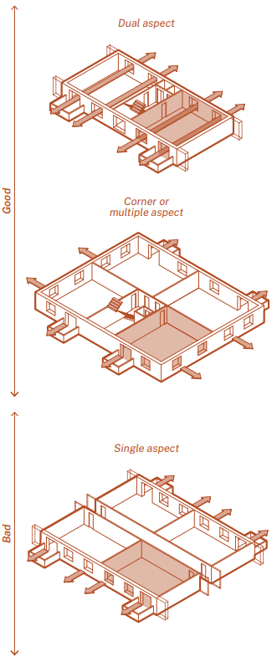
Good outlook - Dual/multiple aspect homes are often defined by:
- Homes with daylight both sides - reducing 'dark space' at the centre of the building plan.
- Improved solar gain and ability to mitigate against glare or excess solar heating.
- Natural, cross ventilation and cooling potential.
- Better opportunities for privacy by having a front and back elevation.
- Flexibility on how spaces are inhabited.
- Options to provide alternative outlook where noise (roads, train lines, junctions) or poorer air quality affect the site.
- Possibility of a window to the kitchen and bathroom to allow better air movement, moisture and odour control (in addition to mechanical ventilation).
- Avoiding excessive net-heat gains ((which can lead to overheating) or net-heat loss (which can result in higher energy consumption).
Bad outlook - Single-aspect homes are often defined by:
- Maximised site density / net to gross ratio.
- Central horizontal corridor without natural light or ventilation.
- Prone to overheating risk due to exposure to solar gain or require additional heating due to lack of solar gain.
- Passive ventilation strategies are less effective and typically rely on mechanical cooling and heating systems, building-in energy dependence.
- Building services along corridor spine walls, limiting scope for internal reconfiguration, lacks the flexibility that many people desire from their homes.
3.3 Solar orientation
Aspect and orientation cannot be thought about in isolation and will be determined by site, context, topography, access and landscape. The orientation of a building and the outlook from within the apartments establishes the principles for heat demand (and loss) and the overall energy consumption.
South facing windows can normally be designed to achieve a net heat gain. However, the amount of south facing glazing should also be optimised to prevent the risk of summer overheating.
East/West windows can provide useful gains, they can often lead to overheating due to the low and prolonged angle of the sun at the start/ end of the day which can be difficult to reduce.
Large North facing windows nearly always lead to net heat loss and need to be optimised – typically made smaller.
Guidance
As outlined in the guidance of Section 3.2 Outlook, primary living and bed spaces should be positioned to take advantage of south facing orientation when accompanied with optimised window sizes and suitable external solar shading. A building’s orientation combined with its glazing ratio is key to minimising energy demand.
Beyond optimising heat gains and losses, the immediate surrounding context can be a contributing factor in determining orientation. In particular, careful consideration should be given to busy roads or train lines which may contribute towards a poor quality of living by excessive noise and air pollution. Habitable rooms should be located away from these areas or mitigated against through good design such as wintergardens.
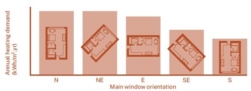
Adapted from the LETI Climate Emergency Design Guide.
North and north-east facing properties have a significantly higher heating demand.
3.4 Elevation and roofscapes
There are no hard and fast rules about the design of elevations. The main components when considering elevation design should be:
- Groundscape - how the building meets the street.
- Mid-rise – the bit in-between.
- Roofscape - how the building meets the sky.
Guidance
Groundscape
How the building meets the street is important. This is space mostly experienced by passersby and residents on arrival. The groundscape should be considered the public facing part to a building and its design will be broadly dependant upon the scale of the building and the immediate surrounding context.
In an immediate urban context, the groundscape could be expressed through taller proportions and/or alternative active commercial uses such as shops or offices. The scale of the groundscape should correlate with the height of the building, the taller the building, the greater size of its surrounding public realm.
In a residential context, the groundscape could be expressed through taller proportions or through alternative ground floor typologies such as duplexes which can be expressed in the elevation design.
Mid-rise
Apartment typologies offer an efficiency through repetition of floor plans. Therefore, the mid-rise is likely to display this repetition and rhythm of floors. Depending on the approach, this could be expressed as a horizontal rhythm or a vertical rhythm, through the arrangement of constituent parts such as balconies or rainwater pipes that reinforce rhythm.
Roofscapes
The roofscape is where the building meets the sky and forms the wider roofscapes of the surrounding area. Modern roofscapes have to work hard. They perform a vital role in water management and energy generation and can offer habitat in the form of green and brown roofs to wildlife. The roof form is also part of the distinctive character of the architecture of a new development, and a key way in which designers can demonstrate and respond to the surrounding context; either following the forms of surrounding buildings, stepping with the topography or offering a contrast with something new.
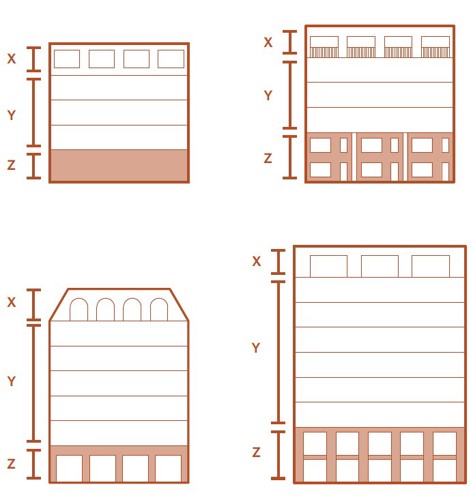
X = Roofscape
Y = Mid-rise
Z = Groundscape
Orwell House, Tower Hamlets, London by Bell Philips uses an ornamental frame/shade to articulate the mid-rise of the apartments. (photograph by Kilian O'Sullivan)
Roof spaces can be congested with roof gardens, plant equipment, communal TV and satellite aerials, biodiverse roofs (green and brown) and energy generation through photovoltaic panels (PVs). Therefore access to them is important. Applicants should demonstrate how these roof spaces are accessible and can be maintained. Roofing membrane, gutters and PVs (to operate efficiently) all require regular inspection by maintenance teams. They should therefore be safe places to access and not require specialist training or safety equipment.
Roof design for photovoltaic panels (PV) should prioritise asymmetric south-facing or east/ west roof pitches for maximum PV energy generation. PVs should be kept away from parapets/upstands to prevent overshadowing and underperformance. Designers should therefore consider locating plant equipment on the roof to the north to avoid overshadowing. Where on-site renewables are not required, or not currently financially viable, roofs should be designed and orientated for future adaptation.
The roofscape is an important design feature, and the plant equipment located on the roof should be considered in terms of integration. Applicants should provide detail demonstrating the plant equipment’s integration within the overall elevation design. Visible or finishing materials used to conceal plant equipment that is not of equal quality to the elevation of the building should not be proposed.
Fully glazed roofscapes or ‘set-backs’ should be avoided as they are an overheating risk.
3.5 Private amenity space
Private amenity space is desirable in all circumstances to create quality places, built for longevity and to support the wellbeing of residents. This could come in the form of a garden, balcony, terrace or wintergarden. A wintergarden is an enclosed balcony with a large ratio of glazing.
Guidance
In very exceptional circumstances, existing site conditions may make it impossible to provide private amenity space for some or all dwellings. Private amenity space should not be located adjacent to areas with high levels of noise or air pollution (although wintergardens could be). To compensate, some/all dwellings in a development may instead add amenity space on to the internal living space.
In the instance of balconies and wintergardens, written agreements with tenants could be used to ensure they are not misused for storage, BBQs or any misuse that may result in a fire risk.
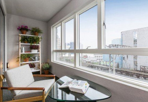
provide a habitable buffer from an adjacent train line. (Photograph by
Nedko Dimitrov)
3.6 Active frontages
A variety of strategies can be used to provide activity at the ground floor. This is often referred to as active frontages and all buildings should be designed to ensure activity throughout the day as a means of providing passive surveillance to the street.
An active frontage can be brought about by several means:
- Ground floor apartments to be accessed via front doors from the street (not via communal entrances).
- Commercial, office or retail uses on ground floor with large windows free from vinyl or obstructions.
Guidance
Car parking should be carefully considered so as to not create inactive frontages. Car parking should not be visible within courtyards as it results in a very poor outlook. Instead, applicants will need to develop solutions to integrate parking within the landscape and housing.
Inactive frontages can be created through the concentration of service doors to waste bins, plant equipment and the back of buildings which will negatively affect the public realm. The location of car parking can also contribute to inactivity. Blank frontages should be avoided.
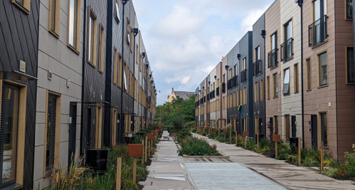
ground allowing a pedestrianised street above. (Photograph by Harper Perry)
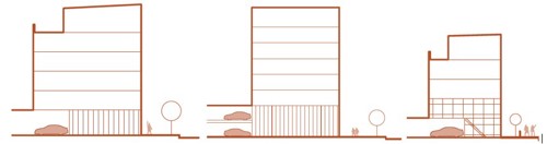
key routes to provide passive surveillance. Location of services should be
minimised and preferably located on the north elevation.
3.7 Balconies
Balconies are essential to providing private amenity space at density. Balconies should be usable places to sit, socialise and grow small plants.
C3.2
Balconies must be a minimum 1500mm deep of clear external space and free from obstruction. Any privacy screens must be integral to the design.
Guidance
Privacy should be carefully considered in relation to the design of balconies to ensure that residents maintain their privacy and feel comfortable to use these spaces well. For instance, fully glazed balconies rarely offer adequate privacy for residents to use the space freely.
Solid upstands (brick/metal/ timber) or heavily obscure glazing should be considered as these help to create privacy. Shelter and comfort should also be considered, including solar shading to be considered in some instances depending on orientation. See Windows (3.9) for more details.
Careful consideration should be given to the drainage of balconies to meet the current requirements of warranty providers/building control, but also to prevent staining or runoff on to residents below. Drainage should be accessible for maintenance and management purposes with a secondary overflow spout to indicate any blockages.
'Juliet balconies' will not be accepted as balconies as they do not contribute any additional external space.
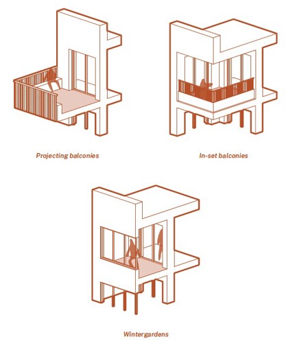
wintergardens. Each providing residents with valuable private external
space outside of the wall of their apartment. Juliets are not balconies.
3.8 Shared external spaces
Living at density should come with significant benefits to the residents living there and should not be about maximising land values at the expense of creating sustainable and desirable places to live.
Offering shared external space provides opportunities for community gardening, food growing and composting.
Guidance
All apartments should have at least one secure outdoor shared communal amenity space. These spaces should be overlooked by residents and accessible to all tenants. These spaces are essential to supporting communities, where family sized homes (+2 bed/3 person and above) are concerned. They should be designed for people of all ages to meet people, socialise, relax, grow food, play and support biodiversity.
Creating homes that will support family lives is important. Providing space for children to develop physically, emotionally and cognitively is important for their development. It is therefore essential that we provide spaces for children of all ages.
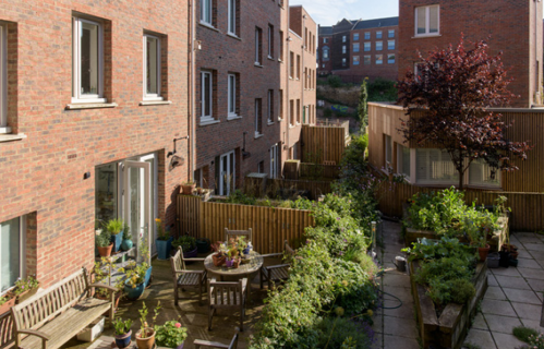
private and communal planting space at a residential development in an
urban area through raised planters, with access provided to communal
water and electricity for maintenance purposes. (Photograph by Jill Tate)
For developments with a potential occupancy of ten children or more, development proposals (in addition to private external space) should provide:
- Development that accords with the Council's Adopted Play Strategy.
- Overlooking by surrounding developments.
- Accessibility to all via level thresholds and not involve stepped access.
- Designs that take advantage of direct sunlight.
- Suitable management arrangements in place to ensure play spaces are cleaned and maintained.
‘Catalogue play equipment’ should generally be avoided as it is often generic (and provides limited interest for children), is costly, and typically requires an intensive maintenance and inspection routine. Bespoke play environments are preferred.
Design teams should look to design elements of landscape that provide ‘multiple affordances’, i.e. different uses for different people such as a low-level wall that might retain a planting bed, whilst also providing a seat for residents to sit and chat, or a child to walk on and practice balancing. The goal is for low maintenance elements where their use is open to interpretation.
Roof terraces are another means to provide external space at density. Communal terraces will need to provide a range of facilities to cater for residents including:
- Seating.
- Canopies and shelter.
- Safe, level thresholds – step free access for all.
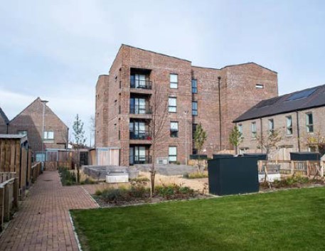
tool shed storage and gardens provides the conditions for community.
New housing in Swindon. (Photograph by Igloo Regeneration)
3.9 Windows
The design of windows and openings define the appearance and character of a building and provide rhythm to the street. The right size and type of windows, located carefully in the building façade will ensure that homes have good quality natural light, natural surveillance, comfort, passive and purge ventilation (with dual or corner aspect homes). They can also contribute towards internal overheating if oversized in East and West orientations or a net heat loss if primarily on North elevations requiring a larger heat load (and unnecessary cost) to residents.
C3.3
Windows must have a minimum reveal depth of 150mm in all new developments.
Guidance
As a general rule of thumb, designers should aim to locate larger windows on the lower floors where access to natural light can be compromised and consider reducing glazing areas higher up the building where there is more daylight available and less overshadowing from neighbouring buildings.
Wider, shorter windows:
- Improve daylight distribution in rooms.
- Moderate overheating risk and are typically easier to shade.
- Increase openable area for ventilation.
- Provide increased privacy to bedrooms.
The south facing aspect of homes should be prioritised for living spaces. Fixed shading on southern facades can provide solar shading in the summer, whilst also supporting heat gains in the winter.
Design teams should aim to increase the pane-to-frame ratio by avoiding unnecessary transoms and mullions as these will significantly reduce thermal performance. Sash windows should be avoided (unless in a conservation context).
Large format windows running floor to ceiling as standard throughout homes can be problematic for a number of reasons. Poorly orientated they can contribute to net heat loss and gains/overheating as they are typically the poorest thermally performing building element (even with triple glazing). To overcome this, external shading is required to prevent overheating and adding cost. Basic internal layouts of furniture (and flexibility) is compromised with residents left with no choice but to abut beds, desks and storage blocking the glazing and visible to the outside.
Windows should be proportionate to the design of the home and quality of space inside. In the right place, large glazing can contribute to the quality of the home – creating an immediate relationship between interior and exterior spaces and allowing good natural light into key habitable rooms.
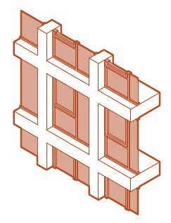
overheating issues and/ or energy intensive
mechanical cooling. Reductions in window
sizes should be considered to mitigate this.
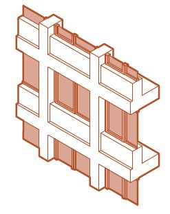
They should not compromise the thermal
transmittance. Insulated render (see
example below) is preferred over integral
window panels as they compromise the
buildings performance.
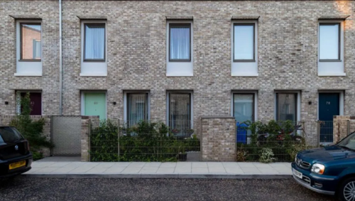
Uses small areas of insulated render below windows to create the
proportion of a large window, without the thermal loss.
3.10 Entrances
Entrances are the arrival point for residents and should offer shelter and protection from the elements.
C3.4
Meter boxes must not be located on primary elevations.
Guidance
All entrances should be clearly illuminated and have level access over the threshold. They should have some form of canopy or protection from the weather which should be integral to the design of the buildings.
The scale, location and design of the entrance should be appropriate to the type of building and number of people using it. For buildings with a high number of residents, entrances will need to be larger and more generous in scale, with robust materials and detailing reflecting their heavier usage.
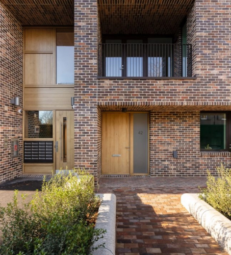
Communal entrance is generous and clear (left of image). Private
residential doors provide further ground floor activity (right of image)
(Photograph by Jim Stephenson)
3.11 Impact, boundaries and public space
Tall buildings have an impact on their surroundings and the taller they are the greater the impact can be. Visual impact is important as tall buildings are likely to be visible from the wider West Bridgford area. Visual impact needs to be assessed from the perspective of several different scales; in relation to its immediate neighbours; close-up as part of the townscape; and in terms of long-distance views and impact on the skyline.
Tall buildings have a pronounced functional impact on their surroundings. This is because of the human activity they generate; pedestrian activity; parking and servicing; shadowing and other climatic considerations such as wind and down drafts
C3.5
Mitigation measures such as tree planting designed to reduce wind speeds must be provided and managed on-curtilage of the
development site in perpetuity. Trees associated with wind mitigation will not be accepted in the carriageway.
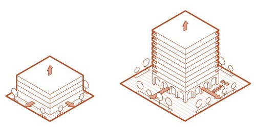
the more generous the public realm should be.
Guidance
Tall buildings will typically be proposed in high population areas and should serve local residents at the ground floor with ‘other uses’ - commercial premises, offices, shops, creche, restaurants etc.
Where other ground floor uses are not suitable in lower rise apartments, applicants should provide front door access to each ground floor apartment as a means of providing an animated street.
Micro-climate assessments may be required for very tall buildings or clusters of tall buildings to understand and propose mitigation against unpleasant or dangerous wind effects that may be created.
3.12 Materials
There are no hard and fast rules when it comes to building envelope design and the selection of materials. The process of selection should take into account a combination of factors, including consideration for the local distinctiveness and character of an area, context, durability/ longevity, maintenance and embodied carbon.
Careful consideration should follow throughout the design process from the external envelope, to the structure and foundations, to finishes and fixtures. This should be evidenced in the planning application submission.
Guidance
Simplicity is often key in robustness of detail, buildability, long term maintenance and weathering. Multiple cladding combinations are generally discouraged unless carefully considered and necessary. Junctions between materials are the most common areas for visible weathering issues and maintenance complexity.
Material selection is always a balancing act.
A solid clay fired brick may be extremely low maintenance, but comes with a high embodied carbon cost and increased loading on concrete foundations that may run contrary to climate goals. Brick slips on a secondary fixing frame allow the appearance of brick with lower carbon cost and lighter dead weight to the structure.
External renders require painting every 5-10 years, but with the right selection of insulation can be very low in carbon, ideal for retrofits and don’t require any foundation reinforcement. However, poor details and interfaces around render with rainwater goods or exposed steel components may result in staining and additional maintenance costs.
Rainscreen cladding is a catch-all terminology to describe a range of panels of differing quality. They vary from high pressure laminates (HPL), to fibre cement based products and folded aluminium. The quality is in the detail and commitment of the applicant to select materials that should weather well. Products that are susceptible to UV damage and bright paint applied colours should be avoided as they are likely to degrade over the medium term.
Retrofitting of existing buildings to extend the lifespan of the structure and/or lower the operational energy consumption is highly encouraged. Retrofitting can be a complex process that require bespoke solutions to each building. Suitable qualifications to design and coordinate the changes are important, such as AECB (Association for Environment Conscious Building) CarbonLite Retrofit, PAS2035 retrofit coordinator or equivalent. See Association for Environment Conscious Building for more details.
3.13 Adaptation
New buildings need to be adaptable to ensure long term sustainability of developments. This is particularly relevant to purpose built student accommodation (PBSA). PBSA typically offer fixed layouts of cellular bedrooms connected to a shared kitchen via an internal corridor. This layout is not conducive to long-term living. Therefore applicants will be expected to demonstrate adaptation to self contained larger apartment typologies without changes to the primary structure or vertical
circulation.
C3.6
Applications for purpose built student accommodation (PBSA) must be able to demonstrate that the development will be able to adapt
to self-contained residential apartments.

of steel balconies, mechanical ventilation extract/ intake and pollution
with light coloured renders result in staining/ discolouring. (Photgraph
by Harper Perry)
Material selection is a balancing act between or a combination of:
- Capital cost
- Maintenance (cost in lifespan)
- Carbon footprint (carbon dioxide equivalent - Co2e)
- Durability
4. Landscape
When to apply this design note
This design note provides essential guidance on integrating new development within our existing areas of landscape and public realm. It outlines the design requirements that designers and developers should follow when creating new places in Rushcliffe.
The guidance aims to ensure that new landscape and public realm enriches the quality of life for all users, promoting ecological health, social interaction, and cultural identity. Where relevant, landscape is an important component in the setting of historic buildings and their environment.
All sections of the design note should be consulted to ensure that landscape and public realm is multifunctional, combining sustainable urban drainage, biodiversity, trees and planting, public realm and shared amenity, play, wayfinding and the use of management companies.
4.1 Sustainable Drainage Systems (SuDS)
Sustainable Drainage Systems (SuDS) are critical to flood attenuation and water resource management. Flood risk is a significant issue in Rushcliffe, with areas of the Borough at risk of flooding from rivers and from surface water. SuDS can contribute towards a reduction in flood risk from development.
SuDS features include rain gardens, swales, retention ponds, detention basins, bio retention, strips, green roofs, and permeable surfaces. SuDS features slow surface water run-off and allow rainwater to be stored close to where it falls. Water can then, where possible, be utilised as a resource, for example, to irrigate trees and planting.
Blue infrastructure refers to networks of rivers, canals, lakes, ponds, reservoirs, streams and ditches throughout the landscape. SuDS systems within a site connect to wider blue infrastructure networks, overflowing into urban wetlands and natural water courses.
C4.1
SuDS features must be designed as part of a coordinated system of strategic blue infrastructure, for example, overflowing into urban wetlands and natural water courses.
C4.2
SuDS features must incorporate resilient planting suitable to wet and dry conditions.
C4.3
Management and maintenance plans must be provided for all new SuDS features.
C4.4
All new homes with gardens, planting areas and/or access to communal planting must be fitted with water butts of a minimum 200 litre capacity.
C4.5
Dry detention ponds must not be part of proposed SuDS features outside of the East Midlands Airport Safeguarded Area.
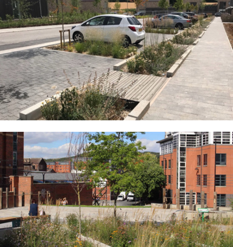
Sheffield Grey to Green - Tree planting in SuDs (bottom). (Photographs
by Robert Bray Associates)
Guidance
Sites should incorporate best practice with regard to sustainable drainage and the management of flood water.
SuDS infrastructure should be considered from the outset when designing new development and should be designed to connect to the wider blue infrastructure network beyond the site boundary. SuDS should not increase flood risk elsewhere and where possible should reduce flood risk. In some circumstances, SuDS may not be feasible, and this should be explained as part of the planning application submission.
Proposals for new development should demonstrate that SuDS are integrated throughout the site layout and design rather than restricted to isolated locations, incorporating attenuation in to the heart of proposed schemes.
SuDS features should incorporate trees.
SuDS features should provide multifunctional benefits, for example, by enhancing biodiversity, and providing opportunities for combining SuDS and recreation.
New development on greenfield sites should reduce or maintain surface water runoff levels compared to those prior to development.
Below ground storage tanks should be avoided and only used as a last resort when surface attenuation has been proven to be unfeasible.
Guardrails should be erected around attenuation ponds where there is an identified need to mitigate the risk presented by open water.
SuDS systems should be planned for exceedance during extreme or prolonged rainfall events to minimise the damage of surface water flow.
Proposals for SuDS within the highway would need to be acceptable to the Highway Authority. It is encouraged that such proposals are discussed with the Highway Authority before a planning application is submitted.
Where it is intended for SuDS to be adopted by Severn Trent Water, it is encouraged that applicants enter into pre application discussions with them.
Refer to
- The SuDS Manual (C753) published by CIRIA
- First Steps in Urban Water: Managing Water as a Resource (2023) published by TDAG
- Greater Nottingham Blue-Green Infrastructure Strategy (2022)
- Harvesting rainwater for for domestic uses: an information guide
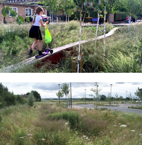
Swale planted for biodiversity and amenity, adding to placemaking
principles by being distinctive and welcoming (bottom - photograph by
Illman Young).
4.2 Biodiversity
The word ‘biodiversity‘ refers to the variety of life on earth, including the different species of animals, plants, and micro-organisms that coexist globally. It also refers to the variety of ecosystems and their component habitats. Examples include wetlands, grasslands, rivers, farmlands and urban landscapes.
Existing grassland, woodland and wetland habitats mean Rushcliffe is an important area for some species of plants and animals. In 2022 there were 8 nationally important sites (SSSIs) and 222 Local Wildlife Sites (LWS) listed within Rushcliffe, in addition to Local Nature Reserves (LNRs).
Biodiversity Net Gain (BNG) is a way of creating and improving natural habitats. BNG makes sure development has a measurably positive impact (‘net gain’) on biodiversity, compared to what was there before development. A Biodiversity Net Gain of 10% is mandatory for new development unless exempt.
C4.6
A minimum of two swift bricks per dwelling must be provided in new residential development in addition to any other ecological enhancements (including BNG).
C4.7
A minimum of three swift bricks or suitable alternative must be installed per unit for commercial and industrial development in addition to any other ecological enhancements (including BNG).
C4.8
Robust boundary materials (including ‘internal’ fences) must be fitted with hedgehog holes in addition to any other ecological enhancements (including BNG).
C4.9
New development must not specify the use of plastic planting or artificial grass.
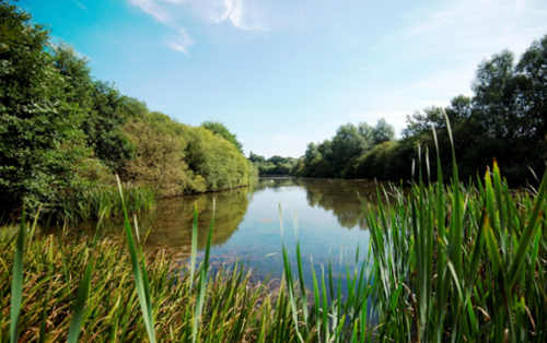
(Photograph by Nottinghamshire Wildlife Trust)
Guidance
All new development which falls within one or more of the focal areas in the Rushcliffe Biodiversity Opportunity Mapping Report should demonstrate how the development proposal has been informed by and will deliver the opportunities for improvement identified within the Report.
All new development should protect existing biodiversity features wherever possible and improve these where appropriate. All new development should demonstrate mitigation measures to minimise impacts to biodiversity.
All new development should provide additional features designed to benefit certain species or groups, for example, bee bricks, nesting boxes for birds, bat boxes, swift bricks and features for reptiles, amphibians or invertebrates. Wherever possible the selection of features should contribute towards the delivery of objectives for priority habitats and species identified in the Nottinghamshire Local Biodiversity Action Plan.
Proposals for new biodiversity features should demonstrate how they are strategically located, planned and managed to provide connections with existing blue and green infrastructure.
Proposals for new development should include a planting scheme which provides a diverse mixture of plants, shrubs and trees to provide habitats and food for wildlife throughout the year.
Where hedgerows are within the red line boundary and watercourses are within 10 metres of the red line boundary, BNG for hedgerows and watercourses must be provided unless the development is exempt from BNG.
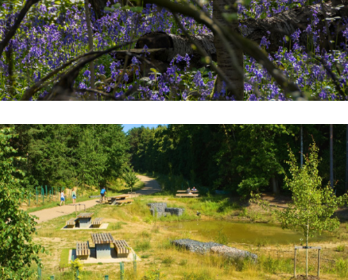
than replacing them with new. Ancient Coppiced Woodland in
Nottinghamshire (Bunny Old Wood West - photograph by Nottinghamshire
Wildlife Trust. Bottom: Brownfield sites pose huge potential for
biodiversity gains. Once the centre for ground-breaking research into
road safety, Buckler’s Forest in Crowthorne was re-naturalised into a
space where both people and wildlife could thrive (photograph by Paul
Upward photography).
Refer to
- Rushcliffe Biodiversity Opportunity Mapping Report (2015)
- Nottinghamshire Local Biodiversity Action Plan
Narrative
The Rushcliffe Biodiversity Opportunity Mapping Report underpins the wider work of the Nottinghamshire Biodiversity Action Group and complies with the Lawton Review of wildlife conservation ‘Making Space for Nature’ which promotes the protection and enhancement of a network of habitats (which are better, bigger, and more connected) rather than individual sites in isolation.
The Rushcliffe Local Plan states that the East Midlands currently compares unfavourably with other regions in England in terms of the surface area covered by designated nature conservation sites, has lost more wildlife than any other region in England and has lost large amounts of its wildlife habitats with losses continuing and those that remain becoming increasingly small, isolated and fragmented. There is a recognised need to deliver a major step change increase in the level of biodiversity across the East Midlands.
Opportunities within new development to incorporate new biodiversity features include wetlands, green roofs, planting of native species, hedgerows, and unimproved grassland.
4.3 Trees & Planting
Trees and planting are building blocks of a larger connected green infrastructure network. Trees have a positive impact on the attractiveness, value, viability, quality and sustainability of new development. Benefits include creating welcoming, attractive and distinctive places, enhancing biodiversity, dealing with stormwater and enhancing thermal comfort.
C4.10
Multifunctional green infrastructure must be incorporated into new development.
C4.11
New green infrastructure features must connect to existing strategic and local green infrastructure.
C4.12
Proposals for green infrastructure must include a management plan for the lifetime of the development.
C4.13
A minimum of one new tree per one parking space provided in the development (including garage spaces) must be planted in the public realm.
C4.14
Trees planted within a hard landscape must utilise a soil structure system to create an uncompacted root zone and reduce the risk of roots lifting surfaces.
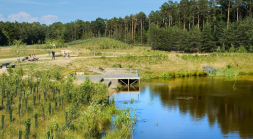
benefits to people, wildlife and landscapes. Embedding quality and
abundant green infrastructure has the benefit of protecting both urban
and rural environments from a changing climate and adverse weather.
Making green infrastructure accessible enhances people’s experience,
understanding and relationship with nature (photograph by Paul
Upward photography).
Guidance
Green Infrastructure
- Proposals for new development should follow the guidance to plan and design good green infrastructure provided in the Green Infrastructure Planning and Design Guide published by Natural England.
- Proposals for new development should follow the Green Infrastructure Standards published by Natural England to drive improvement in the quantity and quality of green infrastructure.
- New development should address the opportunities to protect and enhance green infrastructure set out in the Greater Nottingham Blue-Green Infrastructure Strategy (2022).
- New development should explore opportunities to both provide new green infrastructure and enhance existing green infrastructure.
- Green corridors can make a useful contribution to the wider Active Travel network, especially for leisure trips, but need to be designed with regard to the need for social safety, especially by users outside daylight hours.
- Green infrastructure proposals should demonstrate how they respond to local landscape character by protecting, conserving or enhancing the different landscape types in Rushcliffe in line with the recommendations of the Greater Nottingham Landscape Character Assessment.
- Green infrastructure should be multifunctional, for example: by providing access to employment and leisure facilities; physical activity and wellbeing opportunities; biodiversity opportunities; and tackling and adapting to climate change.
- Where proposed new development has an adverse impact on green infrastructure corridors or assets, alternative scheme designs that have no or little impact should be considered before mitigation is provided, as stated in the Local Plan.
- New residential development should provide communal green space and food growing sites as a component of the green infrastructure network.
- New development should prioritise the modification of the degraded soils and avoid importing manufactured topsoil where possible.
- New residential development should incorporate vegetation and features for wildlife on structures associated with the provision of services or storage, for example, cycle and bin stores, service buildings, sub stations
Trees & Planting
- Proposals for new trees and planting should include a diverse range of species which have been selected to respond to local landscape character, to provide value for wildlife, to reduce vulnerability to the risk of disease, and increase resilience to climate change.
- Planting schemes outside of residential gardens should select tree and shrub species from the guidance published by Rushcliffe Borough Council on tree and hedgerow planting to enhance landscape character, as applies to each of the four regional character areas in Rushcliffe.
- Amenity grassland should be planted with flowering lawn seed mixes.
- New development should incorporate both new and existing trees. In addition to complying with Tree Preservation Orders (TPOs) and hedgerow protection legislation, mature trees, shrubs and hedgerows should be retained where possible.
- New planting should strengthen existing tree lines and hedgerows, and/or create new native hedgerows.
- New streets should incorporate trees with tree pits with a minimum volume of 7 cubic metres to enhance resilience.
- Maintenance of new and existing trees should follow the council’s Tree Management and Protection Policy.
- Mowing should be reduced or delayed to allow wildflowers to grow and provide food for pollinators. Consider mowing strips around the edge of unmown areas to present an impression of ‘management’.
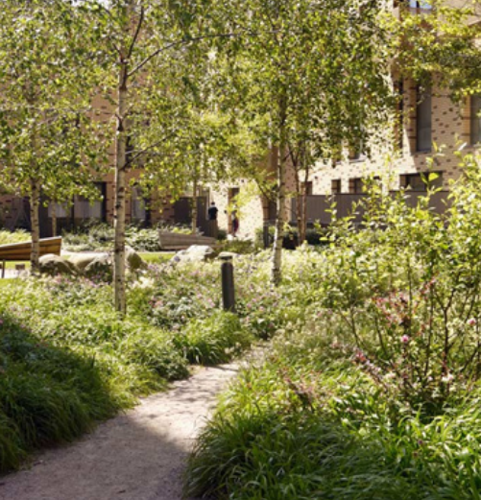
and public places can embrace local landscape character, native
species, and tie into existing green infrastructure (photograph by
Townshend Landscape Architects).
Refer to
- Green Infrastructure Planning and Design Guide published by Natural England
- Green Infrastructure Standards published by Natural England
- Greater Nottingham Blue-Green Infrastructure Strategy (2022)
- Greater Nottingham Landscape Character Assessment
- Rushcliffe Borough Council: Tree and Hedgerows Planting to Enhance Landscape Character
- Rushcliffe Borough Council: Tree Management and Protection Policy 2023
- Tree Species Selection for Green Infrastructure: A Guide for Specifiers published by Tree Development Advisory Group
Narrative
The National Planning Policy Framework 2024 defines Green Infrastructure as ‘a network of multi-functional green and blue spaces and other natural features, urban and rural, which is capable of delivering a wide range of environmental, economic, health and wellbeing benefits for nature, climate, local and wider communities and prosperity’.
Elements of a green infrastructure network vary in scale from strategically important green spaces, linear infrastructure such as roadside verges and access routes, to small features which appear throughout the landscape such as domestic gardens, hedgerows, street trees, ditches, or ponds. A single green infrastructure design can provide multiple functions and benefits.
New developments provide an opportunity to enhance green infrastructure, both within the site or off-site.
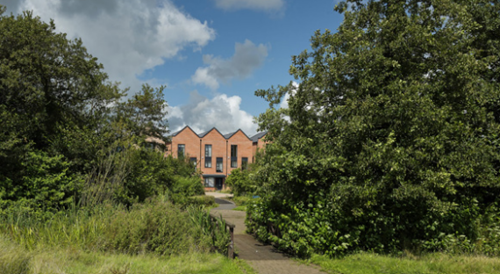
connect rural and urban areas of green space and tree cover.
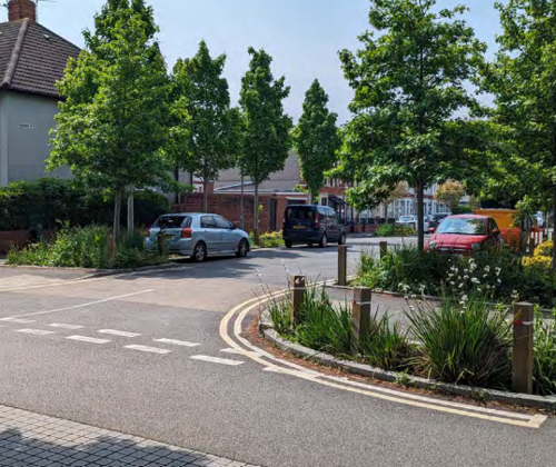
water retention, improve visual amenity, and can be used to extend
green corridors (photograph by Harper Perry).
4.4 Public Realm and shared amenity
Public realm is defined as the spaces between buildings that are freely accessible to people. It includes streets, amenity spaces, open spaces, green spaces, sports and recreation grounds, cycle ways and pedestrian areas.
Shared amenity refers to communal spaces or facilities designed for shared use by residents or the public. Shared amenities typically include parks, green spaces, playgrounds, seating areas, gardens, and other recreational facilities that are intended to enhance quality of life and social interaction.
C4.15
Public realm design proposals must be informed by an analysis of anticipated (in the case of proposed new public realm) movement patterns by users through and within the space, including desire lines.
C4.16
Level access must be provided to all areas of public realm within new development. Where changes of level are required they must be considered in terms of how they promote or restrict access and be clearly communicated.
Guidance
Public realm
The spatial design of public realm, including the layout of elements such as street furniture, planting, trees and lighting, should be flexible to allow for activities and events of varied scales and places to dwell.
Public realm design proposals should incorporate trees and planting which support biodiversity and the creation of new habitats. See 4.2 Biodiversity.
The design of public realm should provide spaces with shelter or partial shelter from wind, rain and sun.
Public realm design should encourage and support active and healthy lifestyles.
Future users of a space should be actively involved in the briefing, design, and development of public realm design. Consultation on public realm design should be accessible and inclusive to enable a diverse range of people to participate.
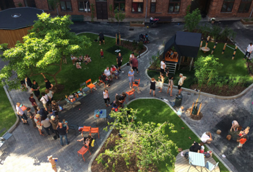
can incorporate seating, shelter, play, movement, and biodiversity
(photograph above by Simon Jeppeson and VEGA landskab, photograph
below by Rolfe Judd).
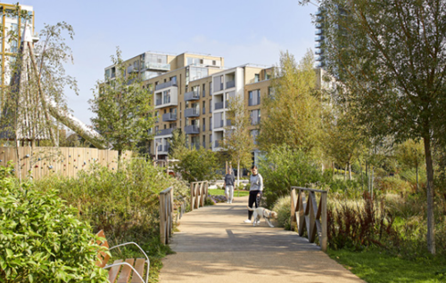
Safety and surveillance
New residential development must be designed to maximise natural surveillance of access routes and public open spaces.
Lighting must create a welcoming and safe environment which encourages the use of outdoor spaces.
Trees and planting in urban areas should be designed and maintained to allow visibility and sightlines to facilitate surveillance, avoiding the creation of isolated spaces.
Appropriate trees and planting can provide cool and shaded places to dwell, make a positive contribution to air quality and create a buffer to roads. Maintenance of trees should follow the council’s Tree Management and Protection Policy.
Street furniture
All street furniture must be consistent in design ‘style’ (style, colour and material) and quality across new development whilst achieving any required distinction between street hierarchy and routes.
Street furniture must be integrated into the design of the public realm.
Street furniture must be positioned to maintain clear walking and wheeling routes, and maintain visibility of entrances and facilities.
Seating
A variety of seating should be provided alongside space for people in wheelchairs to interact with others.
Seating should include opportunities to sit on the periphery of a space, areas which encourage social interaction, and accessible seating with arms and backrests.
Seating should be provided along all walking and wheeling routes to provide opportunities for people to take a rest.
Bins
An adequate quantity and capacity of bins should be provided to support a litter-fee environment.
Bins should be located conveniently with clearly marked options for recycling.
Emptying of bins should be specified in the management and maintenance documents.
Lighting design
Lighting must be present on main, secondary, and tertiary streets.
Lighting in the public realm must not cause a nuisance to residential windows.
Lighting design should take in to account the character of the local townscape or landscape, by selecting an appropriate type, scale and style of lighting for the context.
Designs should seek to reduce the number of lighting columns as these contribute to clutter in the public realm. This might be achieved by using multi-headed columns, by combining lighting with other items of street furniture, and considering wall mounted luminaires where appropriate. Luminaires should be specified for low energy consumption.
Lighting should be designed to minimise their impact in areas which are close to or within green infrastructure and wildlife habitats.
Wayfinding furniture
Signage and wayfinding, including graphic and text-based information must meet inclusive design requirements.
Wayfinding furniture should complement other aides to navigation such as spatial hierarchy, design legibility and material consistency.
Wayfinding furniture should only be used where additional information is required to avoid excessive clutter in the public realm.
Materials
Materials should be chosen which reduce the carbon footprint of the development. The choice of materials should aim to reduce environmental impact, by considering embodied carbon, sustainability of the supply chain, and ongoing sustainability in use.
New development should seek to reuse materials on site wherever possible.
Material choice and design should remain consistent to express the relationship between different areas and the street hierarchy in the public realm.
Materials should be robust and age well, with a life cycle and maintenance requirements which suit the development. Proposals for new development should demonstrate that they have considered the character of areas surrounding the site boundary when specifying materials.
A balance of material transition and continuity should be considered at thresholds and changes between site edges and the wider public realm.
Hard surfaces in the public realm should be porous to minimise surface water runoff and be coordinated with sustainable urban drainage networks.
Sealed surfaces should be avoided.
Detailing of hard and soft landscape materials adds a richness to the experience of a place and should be encouraged early on in the design process to ensure adequate allowances are made for it during the viability and costing process.
Refer to
- Engagement Overlay to the RIBA Plan of Work
- Bat Conservation Trust: Artificial lighting and wildlife Interim Guidance: Recommendations to help minimise the impact artificial lighting
Narrative
Good public realm design makes public spaces and routes pleasant, easy to use, and legible for a range of users. It also considers inclusivity, accessibility, safety and maintenance, as well as how to support community interaction, outdoor activities and wellbeing.
Public realm combines different elements within a successful spatial and functional design. These include street furniture, lighting, trees and planting, hard materials and surfaces.
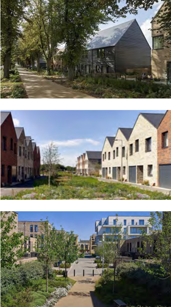
allows for natural surveillance of accessible routes
and public open spaces.
Photographs: top - Pollard Thomas Edwards,
middle - Kilian O'Sulivan, bottom - Timothy Soar.
4.5 Play
Policy for play areas is based on three levels of provision for play friendly spaces (LAPs, LEAPS and NEAPs) that are accessible and inclusive. These relate to the size and level of equipment provided but also the age of the children for which it is designed. Inclusive play spaces should also consider the needs of children with special needs and disabilities, including access for wheelchairs and mobility aids, and multisensory play.
Opportunities to play can also be provided outside of designated play areas. Examples include integrating playful elements along active travel routes and encouraging exploration and play in green space. Natural play space can include trees, planting, natural play features such as logs and boulders, and opportunities to learn about wildlife. A multifunctional approach can provide health and wellbeing benefits to children and young people through access to nature, support biodiversity, and link to the green infrastructure network.
C4.17
Play spaces must be located to create a balance of provision across new developments.
C4.18
Play spaces must be located where they have direct links to walking and cycle routes so that children and young people can reach them safely and easily.
C4.19
Management and maintenance plans must be provided for all proposed play spaces.

the tendency to fence in play (unless specifically required). (Photograph
by John Sturrock).
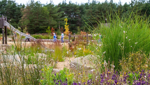
resilience of, nature.
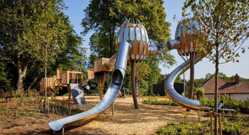
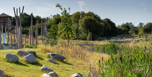
infrastructure. It is aspirational that these elements are considered
holistically and refrain from them being deployed as a ‘tick box’
exercise and applied in isolation.
Guidance
Proposals for play provision within new development should provide accessible and equitable spaces for children and young people of different ages and genders.
Play provision within new development should include opportunities for children and young people to play together.
Proposals for play provision within new development should complement provision available in the wider locality.
Play spaces should be located away from busy roads, noise, pollution and water bodies including sustainable drainage features which hold water.
Play spaces should be located alongside other amenities. Combined facilities encourage children, young people and adults to spend time outdoors together, promote social interaction, increase natural surveillance and a perception of safety.
Fences and gates should only be provided where they are necessary, for example, to contain young children or to keep animals out.
New residential development should incorporate doorstep play spaces at regular intervals.
Refer to
- Make Space For Girls - for guidance on how to make new developments inclusive for teenage girls.
- Rushcliffe Play Strategy
The three levels of designated play area provision are:
- Local Areas of Play (LAP) aimed at very young children, with a few fixed items of play near to the home, and a minimum activity zone area of 100 square metres.
- Local Equipped Areas of Play (LEAP), with at least five pieces of equipment for slightly older children, and a minimum activity zone
area of 400 square metres. - Neighbourhood Equipped Areas of Play (NEAP) aimed at older children, with at least eight pieces of equipment often complemented by other facilities including Multi Use Games Areas (MUGAs) and skateboard parks, with a minimum activity zone area of 1000 square metres.

to ensure a wider range of user needs are heard and met. Photograph
by Robin Hayes.
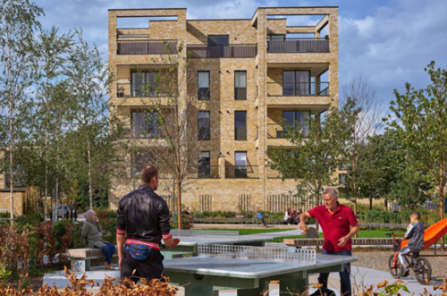
foster collaboration and shared ownership of space.
4.6 Wayfinding & Navigation
Connections that enable transport, active travel, communication, and social interactions across urban and rural areas improve accessibility and mobility for residents, with a positive impact on health and wellbeing.
A well-connected street network enables easy movement by providing straightforward ways to get from one place to another, with short routes and few dead ends.
C4.20
In new residential development communal facilities must be located where they have direct links to walking and cycle routes so that residents can reach them safely and easily on foot or by wheel.
C4.21
Proposals for new development must demonstrate that they provide for clear and easy movement through and within the development area.
C4.22
Proposals for new residential development must provide a well-connected street network within the development and enable connections beyond the site boundary.
C4.23
Major new development must provide integrated active travel routes as part of a safe, attractive and coherent network.
C4.24
Walking and cycling routes must be lit to increase safety and accessibility and designed appropriately for their setting and context.
Guidance
New residential development should maximise walkability.
New residential development should provide access to green space by providing links to parks, green spaces and rights of way.
New development should help to achieve continuous routes connecting the city centre with the urban fringe and wider countryside and major leisure destinations.
Consistent and clear signage is important to encourage active travel, and clearly show the status of routes, such as cycle paths or shared paths. Signage should be well maintained, and include local destinations such as shops, health centres and leisure centres.
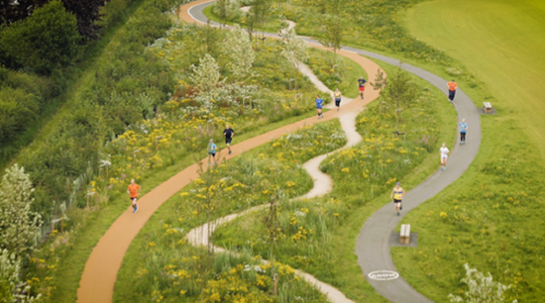
offers opportunities to mix play, movement and biodiversity. Photograph
by Dependable Production.
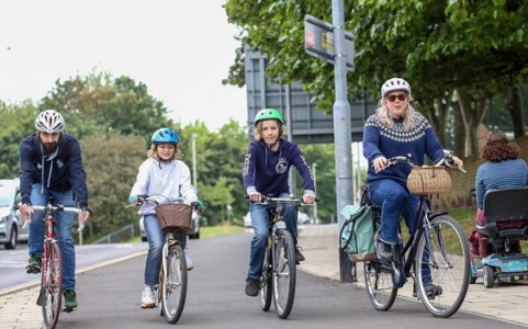
choose active travel to reach essential services, school, work and
leisure spots. photograph by Gateshead Council.
Active travel means getting about in a way that makes you physically active, like walking, cycling or wheeling. It enables people to make short journeys, such as getting to the shops or local school, cycling to work or a public transport hub. Encouraging more active travel provides many benefits – in terms of improved public health and air quality, increased road safety, better street life, and reduced carbon emissions.
4.7 Management Plans and Companies
The management of landscape and its associated public realm is crucial to maintaining a functional, healthy, and pleasant place to live. Management and maintenance of places is generally concerned with incorporating the processes associated with preserving their quality or condition. Good management and maintenance contributes to the resilience and attractiveness of a place and allows communities to have pride in their area.
C4.25
Management plans must highlight areas of landscape, SuDS and play areas for adoption with information on layout, materials, construction details and soft landscaping.
C4.26
Management plans must indicate:
- Land to be adopted by the highway authority.
- Land to be adopted by the Borough Council, a town council or parish council.
- Land managed by a management company.
- Land managed by private landowners.
C4.27
Management plans must promote and encourage cleanliness.
C4.28
Management plans must ensure the successful establishment and continued thriving of all plants and trees, and replacement of all dead or dying trees/plants for a period of 5 years.
C4.29
Developers must create a Habitat Management and Monitoring Plan (HMMP), employing strategies that encourage biodiversity as per section 4.2 Biodiversity.
C4.30
Management plans must outline the goals and purposes of different landscape elements (sections 4.1, 4.2, 4.3, 4.4, 4.5, 4.6) and describe the strategies to be implemented for their achievement.

through long term management plans. Photograph by Farrer Huxley.
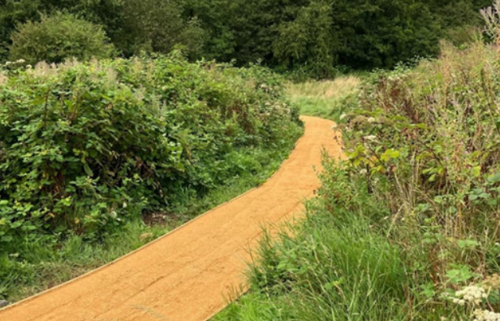
Photograph by Bath and North East Somerset Council.
Guidance
Management plans of public spaces (including private streets and open spaces) should highlight what will be adopted by the Highway Authority and where shared spaces may be jointly or privately managed.
Management plans, where appropriate, should encourage and curate positive activity in the public realm. This might include taking responsibility for seating which is not adopted or associated with a business or operator, caring for planting, and organising social or cultural events.
Management plans should include comprehensive maintenance instructions that balance the ambitions of biodiversity, user experience and cleanliness.
Low maintenance strategies should be designed into schemes where appropriate to reduce the scope of required management.
Robust and appropriate materials should be used that balance design intentions with longevity and maintenance. Damaged materials should be replaced with like-for-like to maintain the quality of design.
The Landscape and Ecological Management Plan (LEMP) should outline the strategies for preserving the existing ecology and maintaining the landscaped areas within a development. It should ensure that the planned landscape functions effectively, serving purposes such as creating habitats and offering recreational zones.
Developers should consider submitting a Construction Environmental Management Plan (CEMP). A CEMP document outlines how a developer will minimise any negative environmental impacts of a specific construction project. A CEMP should also demonstrate that a construction project complies with any relevant environmental legislation.
The expectation is that guardrails should be erected around attenuation ponds where necessary for reason of safety.
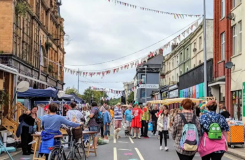
in enriching cultural events. Photograph by One Plymouth.
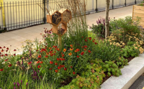
success of construction, maintenance and biodiversity strategies.
Management plans set out the approach to adoption and management, and can range from the environmental, meaning wildlife is catered and cared for, right up to the bustling urban centres and high streets, where our streets and public spaces are managed to maintain thriving places.
The best examples of successful management plans include the potential for community engagement and management, shared responsibilities, and clear goals and outcomes. Management companies should use the guidance within this Design Code and Rushcliffe's Management of Open Space Good Practice Guide to inform the creation of their management plans at the earliest stage possible. Where a Management Company is being brought in to look after the management and maintenance of a private place, they should also ensure they are in accordance with the guidance.
5. Householder
When to apply this design note
Extensions and alterations to existing homes are often required to accommodate the changing needs of households. The guidance in this section relates to changes to individual houses in the form of alterations, extensions and annex buildings. The design note aims:
- To provide clarity for homeowners planning to extend or make alterations to their home.
- Ensure that extensions and adaptations do not unreasonably reduce the privacy of neighbouring properties.
- To ensure changes to a house/s do not result in harm or loss to the continuity of historic streetscapes.
- To ensure that changes are not detrimental to the architectural qualities and characteristics of the original building and its setting.
Process
When considering an extension or alteration to your home, you will need to determine if the proposed works require the submission of a householder application (planning application), or whether it is covered by ‘permitted development’.
The best way to understand if your proposal requires the submission of a planning application is to use the Rushcliffe Borough Council Householder Enquiry Service.
Check, Do I Need Planning Permission webpage.
Process flow
Plan to alter your home?
- Engage design professionals:
-
- architect
- surveyor
- engineer
- builder
Complete a householder enquiry form. Speak to neighbours, discuss design, changes and likely impact, also note party wall agreement.
- Permitted development - Lawful development Certificate issued
- Conservation Area
- Permitted development - Lawful development Certificate issued
- Development - Household Planning Application
- Development - Household Planning Application
- Listed building - Listed Building Consent - Household Planning Application
Professional services
Engaging a design professional, such as an architect, is recommended. They will guide you through the process from initial ideas, to engaging specialist consultants and ensuring the right permissions are in place.
The Architects Registration Board maintains the UK Register of Architects, and only people on the Register are legally allowed to use
the title ‘architect’.
Selecting a reputable builder can also help to ensure that design and construction processes run smoothly. The
Federation of Master Builders has a ‘Find a Builder’ tool, allowing you to search for professionally vetted builders.
Development
Householder applications will be reviewed against this design note, and other relevant policies such as conservation area management plans. The application must be approved before building work commences otherwise you will be in breach of planning law.
Permitted development rights
Permitted development (PD) rights allow you to extend or alter your home without applying for planning permission in certain situations. The Government have produced the following guidance on permitted development:
- Government Guidance: When is permission required?
- Government Technical Guidance: Permitted development rights for householders
- Planning Portal: Do you need permission?
It is the responsibility of the applicant to find out whether an extension or alteration requires the submission of a planning application. Permitted development rights are subject to change and, even where the proposal is classified as ‘permitted development’, householders should apply for a Lawful Development Certificate to verify that the work was legally permitted at the time it was carried out.
Conservation Areas
There are a number of Conservation Areas in Rushcliffe. These are outlined in detail in Area Management Plans and Character Statements.
Listed Building Consent
Listed buildings have statutory protection against extensions and alterations which could harm their special architectural or historic interest. Extensions and alterations, including internal changes and works to curtilage listed buildings require Listed Building Consent. External works to a listed building may require a detailed planning application as well as an application for Listed Building Consent.
Speak to neighbours
Alteration and extensions to individual dwellings can sometimes cause disputes between neighbours. When you submit a planning application, your neighbours will be informed of your application and will have the opportunity to comment on the proposals.
It is not the role of the planning system to resolve private issues between neighbours, but we highly recommend speaking with neighbours informally prior to submitting any application to avoid any misunderstanding. Early conversations allow concerns to be
raised during the design phase and can help avoid disputes at a later stage.
Working on or near the boundary or shared party wall will be subject to the Party Wall Act 1996. It covers shared walls, fences, gutters and foundations and provides a framework for protecting both parties’ interests during construction work on a party wall or structure. Boundary issues are usually a civil matter rather than a planning consideration, and it is the applicant’s responsibility to ensure that you comply with the Party Wall Act when planning and undertaking any construction project.
More information is available here:
- GOV.UK - party walls and building works
- RICS Consumer Guidance to Party Walls
- Or appoint a RICS approved chartered surveyor
5.1 Context and Character
The context of a home is important to consider when designing alterations and extensions.
Character of the original building:
- When was it built?
- What makes it different from other homes?
- What are its characteristic details and architectural language?
- Materials, lintels, decoration
- Windows
- Form, size and layout
- Architectural period
Character of the outdoor space:
- Are there existing trees or hedgerows?
- Does it have gardens, front, back, size?
- What are the boundary wall details and finishes?
- What is the topography like – are there changes in the site levels?
Character of the immediate surroundings:
- How does it relate to neighbouring houses - detached, semi-detached or terraced
- What is the street outside like – is it tree-lined, are there consistent garden walls, building frontages, entrances?
Character of the wider local area:
- What is the dominant architectural period? Rural cottages, Victorian or post-war for example?
Guidance
Good householder development respects the context and character of the home. Proposed alterations or extensions respond positively to features in the environment, rather than removing or undermining them. Planning decisions will reflect the context of each application. A particular type of extension may be appropriate in one area but inappropriate in another.
Each home contributes to the overall character of a street or neighbourhood. Alterations and extensions should be sympathetic, with the aim to preserve or enhance the character of the house. Openings, ornament, lintels, eaves and materials should usually be aligned with features on the existing building. The shape, pitch and materials of the roof can also have a significant impact on cohesiveness, and so extensions are expected to match the roof form of the original house.
Extensions should ‘support’ the existing character rather than undermine or dominate.
Changes to the proportions and mass of a home should not imbalance the street scene. The assumption is that in most cases, the extension will be smaller in volume and in height than the original house. Extensions should not result in harm to a street scene by respecting established building lines and form.
The existence of poorly designed extensions and alterations in the local area will not be considered sufficient justification for non-compliance with current design standards. Planning officers reserve the right to determine planning applications based on their
own merits according to current policy and guidance.
5.2 Neighbour amenity – privacy, overbearing, light, impact
Changes to a property will in most instances result in a change to the outlook for the people who live around you. As outlined, applicants should speak with neighbours early on about their proposed plans.
Alterations and extensions that change the building volume through dormers affecting the profile of the roofline, and extensions that extrude beyond the existing footprint of the building may impact a neighbouring property and alter the quality of light and privacy.
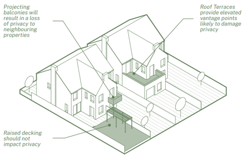
Damaging adaptations that may be detrimental to neighbours’ enjoyment
of privacy. Any additional 'screening' to mitigate against privacy is likely to
result in forms out of scale in a domestic context.
- Projecting balconies will result in a loss of privacy to neighbouring properties
- Raised decking should not impact privacy
- Roof Terraces provide elevated vantage points likely to damage privacy
Guidance
Proposed extensions and alterations to a home must not damage or be detrimental to the privacy of a neighbouring property. Privacy may be harmed through increased overlooking via (but not exclusively):
- New raised decking, landscaping or raised structures
- Projecting balconies
- Roof terraces
Whilst it may be possible to screen balconies or roof terraces between properties, the screening is likely to increase the mass and overshadowing of the neighbouring property (see principles below).
When designing an extension, applicants should endeavour to be a ‘good neighbour’ and mitigate the impact of any changes. To measure impact and loss of light, some simple principles have been established to help applicants and their designers assess the impact of the proposals on their neighbours.
A new extension should not obstruct light into a neighbouring property if the following principles are followed:
Principle 1: For back-to-back facing buildings, a 25 degree line drawn from the window of the habitable room should not be obstructed by a new extension.
A new extension should not obstruct light into a neighbouring property if the following principles are followed:
Principle 1: For facing buildings, a 25 degree line drawn from the window of the habitable room should not be obstructed by a new
extension.
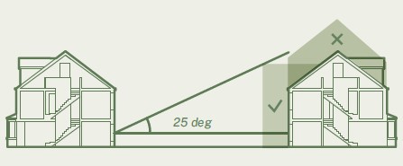
Principle 2: Extensions should not adversely impact neighbouring homes. A 45 degree drawn from the highest point on the proposed extension should not result in adverse overshadow. Where there are two windows, the overshadowing should not obstruct one of the windows. Where there is only one window to a habitable room, it should not be obstructed by the 45 degree line.
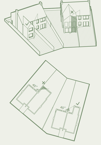
to reduce impact on neighbouring homes by using
the 45 degree principle.
5.3 Extensions
Side extensions can have a significant impact on character and continuity of a street. Any proposed extension should respect the street pattern and elevation.
Overshadowing, loss of privacy, loss of light and any overbearing impact on the existing building and neighbouring buildings are the key issues when determining applications for extensions. Over development of a site can result in long term damage to an area.
C5.1
Side extensions must not result in development within 1 metre of a common boundary with a neighbouring house or where terracing would result.
C5.2
Where there is a consistent rhythm to the street scene, in terms of setbacks, heights, separation distances and materials palette, this must not be interrupted.
C5.3
Extensions must not result in blank gables to the public realm. There must always be a minimum of one window from a habitable room at ground floor level.
Guidance
Over-development of side extensions can result in a ‘terracing’ affect, where the continuity of detached or semi-detached streets are changed into terraced streets.
Extensions should not seek to dominate or match the original house but rather be subservient to it and therefore set back and set down, unless the original building is of such poor architectural quality that it warrants a completely fresh architectural approach' Side extensions on corner plots should have a minimum of one window from a habitable room on ground flood level looking on to the public realm, with landscaping and boundary details complementing the street.
To protect the privacy of neighbours, windows on the side elevation of extensions that are in close proximity to a neighbour’s boundary should be avoided.
Where side extensions result in the loss of a location to store waste and recycling bins, a suitably designed external bin store should be provided.
Householder applications should comply with following maximum built area limits in relation to the overall plot size.
| Undeveloped curtilage - see note below (sqm) |
Maximum footprint as % of undeveloped curtilage |
|---|---|
| Less than 100 square metres | 40% |
| 100 to 500 square metres | 30% |
| 500 to 100 square metres | 20% |
| Over 1000 square metres | 15% |
Note: Undeveloped curtilage = Total plot area less footprint of the original building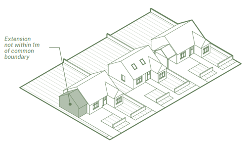
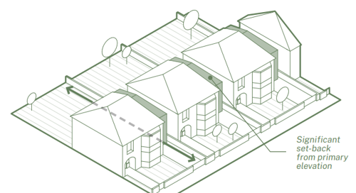
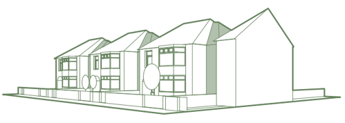
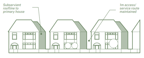
through set-back side extensions, with subservient roofline to primary
house and 1m access/service route to be maintained.
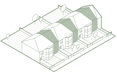
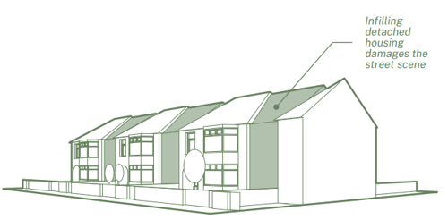
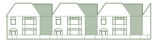
Infill which damages the appearance of the street by creating a terracing
effect will not be accepted.

| Example | 1 - in diagram above | 2 - in diagram above | 3 - in diagram above | 4 - in diagram above |
|---|---|---|---|---|
| Undeveloped curtilage - square metres |
100 | 250 | 750 | 1200 |
| Maximum footprint new extension |
40 | 75 | 150 | 180 |
Guidance
This guidance should be applied in conjunction with the other applicable design codes and guidance and planning policy requirements, which may further reduce the acceptable built area. If there are exceptional circumstances for these built area limits to be exceed, this must be fully justified.
Roof form is an important factor when considering the impact of an extension to neighbouring homes. Flat roofs can be one of the most efficient forms in keeping the roof profile and impact low. Mono-pitched roofs tend to impact adversely on one neighbouring property.
On corner plots where single storey extensions are visible from the public domain, they should be considered in the context of the street pattern.
Roof terraces and balconies which provide external access from upper floors will not be accepted where they result in substantial overlooking issues and loss of privacy for neighbours.
Where a rear extension extends beyond the gable wall, side extension code and guidance applies.
5.4 Dormers
Dormer windows can be a useful way to create additional rooms within the roof space of an existing building. Dormers should appear as a feature within the roofscape and not dominate or overwhelm the building and/or terrace.
C5.4
Dormers on front elevations will only be accepted where there is an existing historic precedent of dormers on the front elevation in the vicinity and the proposed dormers follow the existing proportions.
C5.5
Dormers must be inset by a minimum 500 mm from party walls, eaves and ridges unless justified in a Heritage Impact Assessment.
C5.6
Dormer extensions on side elevations will not be accepted.
Guidance
Dormer windows should normally not be wider than the windows below in elevation. Deviations from this principle should only be allowed if exceptional design and quality are demonstrated. Large dormers, particularly on corner plots can detract from the character of the area and damage the continuity of the streetscape. Some roof spaces, particularly existing houses with shallow pitches may not be suitable for conversion to habitable rooms. External drainage from new bathrooms in the attic space should be discrete and incorporated into the design proposal at planning stage.
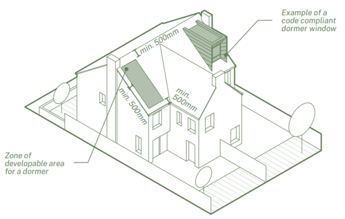
result in the extension being a minor element.
- Showing an example of developed dormer using principles
- Zone of developable area for a dormer
5.5 Outbuildings
An outbuilding is defined as a separate, secondary or independent building within the boundary of the land of an existing primary house. Typically, the outbuilding will share the same services as the primary house, such as the entrance/driveway, parking arrangement and garden(s), and they will be dependant and support one another.
If the new outbuilding is intended to be occupied independently, sold separately, or a guest house/rental, applicants will need to apply for planning permission for an additional dwelling.
Guidance
Outbuildings with a combination of facilities that include the primary aspects of residential accommodation (bedroom, living room, kitchen, bathroom) will be conditioned for ancillary use only. A clear dependency to the original home should be maintained in perpetuity.
Outbuildings in the primary frontage should not be accepted.
It is expected that the overall area of outbuildings should comply with the guidance set out above for maximum built area limits in relation to overall plot size.
5.6 On-site Renewables
The integration of renewable energy sources on individual homes can contribute towards the decarbonisation of domestic power use. However, the integration of renewable energy technologies should not be to the detriment of the immediate housing area or cause nuisance through noise.
Guidance
Photovoltaic Panels (PV) should be designed as part of the building form.
On primary elevations or visually prominent roofs, PVs should be:
- Mounted as integral photovoltaic tiles.
- Set into the profile of the roof structure.
On secondary or rear elevations, PVs should:
- Not extended further than 200 mm from the profile of the existing roof structure.
New development should not overshadow neighbouring roof mounted renewable energy installations.
Air Source Heat Pumps (ASHP) should not be located on primary or side elevations. ASHP if correctly installed and well-maintained should be below 45 decibels (the background noise of urban areas is typically 60 decibels). ASHPs should:
- Be located towards the rear of the house, or to the side of the house, if the side does not front a highway
- Preferably away from neighbouring properties.
- Consideration should be given to ASHP relationship with the windows of neighbouring homes to reduce any noise impact.
Solar Thermals should be designed as part of the building form.
On primary elevations, they should be:
- Set into the profile of the roof structure.
On secondary elevations, they should:
- Not extended further than 200 mm from the profile of the existing roof structure.
C5.7
New development should not overshadow neighbouring roof mounted renewable energy installations.
5.7 Materials
Applicants should consider a range of different factors when choosing what materials to use, including:
- Appropriateness to the age and architecture of the original house.
- Context and location of the proposed new building or extension, whether to the front, side or rear, and how it relates to the surrounding streets and buildings.
- Carbon impact of different materials.
- Availability and cost of materials.
Guidance
Where extensions are visible from the street, the impact of material selections on the surrounding area will be prioritised in determining the planning application. Materials should reflect the qualities and characteristics of the street and should not add new materials to the street palette unless justified when taking into account the local context.
5.8 Gardens
The front and rear garden are an important space and often a defining feature of a home, reflecting the age and architectural quality of historic houses and streets.
Gardens support and enhance biodiversity, provide on-site water management, reduce surface water runoff into existing drainage infrastructure, support wildlife and allow space for growing food.
Front gardens provide an important threshold between the public street and the privacy of the home. Well-maintained front gardens also contribute to a pleasant streetscape. Rear gardens provide an important social space for residents and a place of general privacy.
C5.8
All front and rear gardens must include at least 50% natural grass, planting and other forms of living vegetation.
C5.9
Proposals to enclose gardens facing the public realm must off-set boundary treatments by 1 metre from the highway and be screened
by soft landscaping.
C5.10
Raised platforms in rear gardens must be installed with privacy screens where required.
Guidance
Proposals should respect and enhance the local character, maintaining or carefully adapting boundary details and materials.
Porous surfaces such as planting and soft landscaping should be maximised to allow runoff water to be absorbed and held onsite. Non-porous surfaces (blacktop and block or concrete paving) should be kept to a minimum as they reduce biodiversity and contribute towards increased runoff and localised flooding.
Changes to boundary walls and dropped kerbs to gain access over the highways (pavement) requires planning permission on classified roads and generally will not be supported. Bin stores (see section 1.9 Recycling and waste storage) and bike storage (see section 1.8 Cycle storage) are strongly encouraged to conceal bins and bikes whilst maintaining attractive frontages.
Water butts are strongly encouraged to reduce run-off water into surrounding surfaces and drainage. Privacy screens may be required in relation to rear and side extensions to maintain privacy.
6. Rural
When to apply this design note
The rural area is to be applied as per the area types map and is relevant to the majority of the Borough outside of West Bridgford and the key settlements.
The purpose of the design note is to:
- Preserve and enhance the distinctive rural buildings and landscape of Rushcliffe.
- Support new uses for buildings to ensure they exist for future generations.
- Retain the character and architectural integrity when converting traditional rural buildings.
- Ensure changes in the rural area types are in scale and appearance.
- Continue a tradition of conserving, restoring and enhancing the diversity of landscapes, historic farmsteads, wildlife and the wealth of natural resources.
6.1 Conversion of existing rural buildings
Traditional rural buildings are those built before 1919 with solid wall construction. In Rushcliffe many farmsteads and other traditional buildings are heritage assets which make an important contribution to landscape character and local distinctiveness. They do so through a diversity of uses which are of benefit to local communities and economies.
Without appropriate uses to fund their long-term maintenance and repair, traditional rural buildings will disappear from the landscape. Whilst poor adaptation poses a threat, new commercial, residential or other uses that enhance their historic character and significance are encouraged.
Converting traditional rural buildings to a new use when they are no longer suitable for their original intended use is a good way to protect the heritage of an area and reduce the environmental impact of creating a new building. Conversions must be sympathetically carried out in a way which does not erase the previous history of the building or site.
Not every building will be suitable for a new use. New uses must be carefully considered to make sure they are appropriate for the existing building.
C6.1
When converting a traditional rural building, the original openings in the external elevations must be retained.
C6.2
New masonry chimneys will not be acceptable when converting traditional rural buildings.
C6.3
Dormer windows will not be accepted in conversions of traditional rural buildings.
C6.4
New porches will not be accepted in conversions of traditional rural buildings.
C6.5
Where existing traditional rural buildings have a strong and established linear form, alterations as part of a conversion scheme must reflect that linear form.
Guidance
The conversion of a traditional rural building should preserve the key defining aspects whilst enhancing the building with new sensitive and respectful changes that do not compromise its heritage. Applicants should maintain existing features including lintels, key stones, brick coursing and brick types, matching new to the original proportions and materials.
Openings, windows or doors that define the elevation of a traditional rural building should be maintained. New openings or changes should complement the scale and proportion of existing features and should not undermine the defining features. For instance, new floor plates should not be positioned across existing window openings. Proposed internal layouts should respond to the bays of the original building. Disproportionately large new openings in elevations and roofs will not be accepted.
Internal plans should demonstrate that the proposed layout reflects the historic room layout without adversely affecting the external appearance. New openings should not be proposed when existing openings are removed or blocked up instead of being utilised.
- Avoid a regular pattern of openings – too domestic in appearance.
- Filling in existing openings with glazing, set back with a reveal, is acceptable.
- Juliet balconies will not normally be accepted.
A rooflight can provide additional light and enable the internal adaptation of the layout without adversely changing the elevation. However, rooflights must be used minimally as they are a non-traditional feature. Proposed rooflights should be of a low-profile ‘conservation’ rooflight.
Ventilation
- Ventilation features retained.
Barn doors/shutters
- Existing openings should be retained and not bricked up. The retention of barn doors and shutters should be designed into the scheme and can be used as a wall feature.
Boundaries
- Post and rail fencing and/or native hedges are acceptable. Timber close-boarded fencing is not acceptable. Planting of ornamental species, such as Leylandii, is not acceptable.
- New boundary features must reflect historic boundary features such as hedgerows, stone and brick walls, or footpaths.
Extensions
- Extensions must retain the traditional form of the buildings. In Rushcliffe these are generally courtyard, U-shaped or L-shaped. An offshoot extension is not acceptable.
- The transition between existing and new elements of a traditional rural building can be challenging. One acceptable approach could be the use of glazed ‘links’ that provide a transition. ‘Links’ should be considered as minor elements in elevation and mass.
Garages
- Cartsheds, where present, should be re-used as garages before new garages are proposed.
- Domestic/suburban garage typologies are not acceptable.
Materials
- When converting a traditional rural building, new wall and roofing materials should match those in the historic building, except where use of contemporary materials can be justified.
- For small-scale work, the use of second-hand materials should be prioritised.
- UVPC window and door frames are not acceptable as they have a bulky profile. Modern narrow-profile materials, such as brushed aluminium, are acceptable.
- UVPC gutters are not acceptable. Cast iron is acceptable.
Refer to:
- Historic England’s guidance on caring and adapting Farm Buildings and Traditional Farmsteads
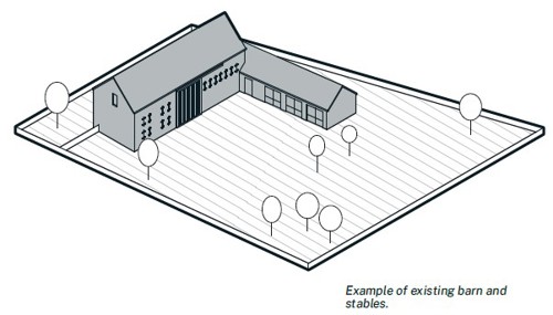
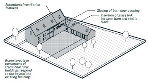
6.2 Replacement dwellings in the open countryside
C6.6
Replacement dwellings in the open countryside or Green Belt must not exceed by more than 50% the volume of the original building, including outbuildings within 5 metres of the host dwelling.
C6.7
Extensions within the open countryside or Green Belt must not increase the size of the dwelling by more than 50% of the volume of the original building.
Guidance
Detrimental impacts on the countryside or unneighbourly effects due to bulk, scale, massing or design could render the proposal unacceptable.
Replacement dwellings and extensions within the 50% rule are unlikely to be considered disproportionate in size increase alone. Replacement dwellings and extensions should not result in an urbanising effect on the character and appearance of the countryside.
For example, the replacement of a small country dwelling with a disproportionately large house in volume, elevation, siting and mass can radically harm the rural character of a village or countryside location.
A replacement dwelling should follow the existing siting and building line unless the dwelling is an anomaly within the surrounding context. Replacement dwellings should reinstate building lines which may have been lost through more recent development. The height should not significantly exceed the existing height. Additional floors are unlikely to be accepted.
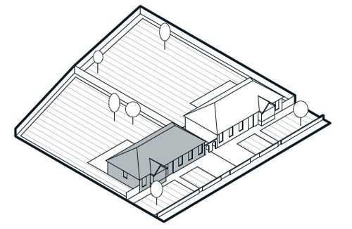
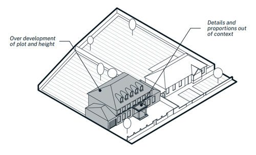
Overdevelopment of plot and height, and details and proportions out of
context.
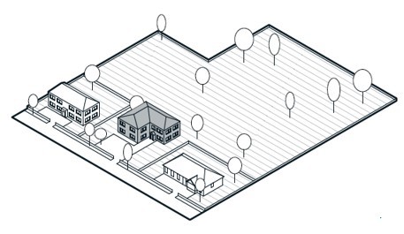
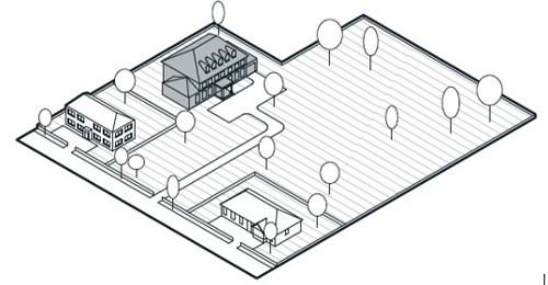
that does not follow the existing siting and building line. It is also
disproportionate in form and scale.
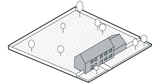
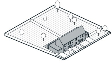
countryside that are of a similar form and scale to the
original dwelling.
6.3 Equestrian development
Equine sports and leisure play an important role in the rural economy of Rushcliffe. The following section provides clarity on ensuring that this economy is supported with clear guidance on changes to the landscape or buildings for personal or professional use. These may include stable buildings, jumps, muckheaps, field shelters, exercise arenas and anything else needed to care for the welfare of horses.
The objective is to ensure development enhances and preserves the rural architecture and landscape.
C6.8
Applications for more than four small stables and one storage area for tack, hay, animal feed and so forth in one given location are not acceptable, unless supported by an existing business case.
C6.9
Stables must not be located on an exposed skyline.
C6.10
Tack rooms and hay stores must be integral to a stable block and be of a size similar to a small stable.
C6.11
Muckheaps must not be sited where they will contaminate watercourses, cause nuisance to public rights of way or adjacent to dwellings.
C6.12
Exercise areas/menages must be constructed with visually unobtrusive surface materials. Bark or recycled chippings are acceptable.
C6.13
Bituminous macadam must not be used for hardstanding areas.
Guidance
Stable buildings:
- Stables should be located close to existing buildings and trees to maximise protection and minimise visual impact.
- Stable dimensions should meet the recommendations of The British Horse Society.
- Concrete blockwork, brick or stone is not an acceptable construction material, however internal blockwork of up to 1.2 metres or low brick plinths below timber walls is acceptable.
- The application must propose sufficient grazing land, as recommended by the British Horse Society, to support the number of intended horses.
Exercise Arenas/Menages:
- Sited to be as inconspicuous as possible.
- Surface materials must be visually unobtrusive – bark or recycled chippings are acceptable.
- Post and rail fencing is acceptable.
- Urban/close-boarded fencing is not acceptable.
- External column lighting should be avoided.
Hardstanding:
- Crushed stone, rolled gravel or grasscrete is acceptable.

proximity to existing buildings.
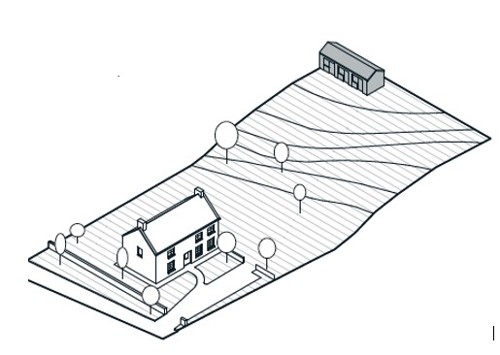
prominent parts of the landscape.
7. High Streets and Local Centres
When to apply this design note
Active high streets and the design of shop fronts play a significant role in shaping and maintaining attractive town, neighbourhood, and village centres.
Many high streets within Rushcliffe are situated within conservation areas. In these areas the priority should be to protect and enhance the traditional design of shop fronts, including taking opportunities to reinstate traditional shop fronts where they have previously been lost. Outside of conservation areas a more contemporary approach may be appropriate provided the code and guidance set out in this design note are followed.
7.1 Active high streets and local centre
Traditionally our high streets provide a focus of activity and a heart to our neighbourhoods. Trends in retail and how we access different services have changed over time but the importance of the high street for local communities remains strong.
People are usually attracted to lively high streets, full of activity and bustle – a place to pop for daily essentials, or to browse and spend a large proportion of the day. The level and type of activity taking place along a high street is influenced by several considerations including the way buildings meet the street, the type and intensity of uses at ground floor level, and the ability of pedestrians to move about freely and cross the street safely and easily.
C7.1
Developments on High Streets must include active ground floor uses.
C7.2
Developments on High Streets must orientate buildings to face the street, with their entrances located on the street frontage.
Guidance
High Street design
New development on an existing high street or involving the creation of a new high street must promote active ground floor uses that liven up the public realm by orientating buildings to face the street, with their entrances located on the street frontage. Lots of windows will increase overlooking onto the street, enhancing natural surveillance and promoting a positive relationship between the inside and the outside.
People are naturally curious of their surroundings and many of us enjoy ‘people watching’ and watching the world go by. Mixing uses vertically along a high street (or within a local centre) with dwellings and workspaces located above commercial and other public uses is a good way to maintain the upkeep of upper floors and helps prevent ‘dead space’ above commercial units.
Lining the edges of high streets with narrow fronted buildings with a direct frontage-to-pavement relationship helps bring life and activity onto the street. Continuous building lines along the street will also encourage activity and avoid breaks in frontages which can diminish the sense of enclosure and continuity. Applicants and their design teams should also consider the ‘ground floor zone’ where
buildings can ‘spill-out’ onto the street in the form of dedicated pavement cafes and terraces without compromising on footpath space. A minimum of 2 metres unobstructed footpath should be maintained.
Retail centre developments
In most cases where a new retail centre is being proposed, a cluster of premises enclosing a central space is the preferred form of development. This preference is supported by an understanding of existing local centres across Rushcliffe, where those within nucleated settlements - that is where the local centre has developed around a central node, such as a marketplace – tend to support higher levels of activity and uses compared to their linear high street counterparts.
The form (or shape) of a focal place with buildings clustered around its edges, tends to encourage people to stay for longer and feel comfortable within the enclosed space where activity is generally high, but speed of movement is low. By contrast, a linear arrangement such as a row of shops, tends to increase the speed at which people pass through and reduces the level of activity taking place.
A proposed retail centre should have gently increased density (in relation to the surrounding development) to signifiy the increase in intensity. This may include first floor residential uses above ground floor commercial and community uses.
New retail centres are generally better located in central, multi-purpose locations for example near local parks and play areas or incorporating larger facilities such as schools and health centres.
Retail centres should have good access to public transport networks and promote active travel opportunities as well as provide sufficient and well-integrated short stay parking appropriate to likely levels of use.
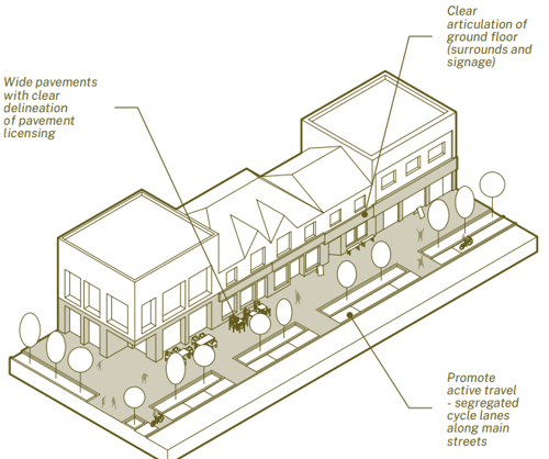
- Clear articulation of ground floor (surrounds and signage)
- Promote active travel - segregated cycle lanes along main streets
- Wide pavements with clear delineation of pavement licensing
Features such as picture windows, detachable awnings, window seats and shop fronts with wide openings can be successful at providing respite and/or exposure to weather conditions as appropriate, as well as animate the building facade and create opportunities for interaction between the inside and the outside.
7.2 Shop frontages and signage
Rushcliffe expects well-designed shopfronts that contribute to the vitality and appeal of high streets and local centres whilst maintaining elements of variety and distinctiveness to guard against the risk of becoming a clone of identikit commercial high streets.
C7.3
Shopfronts must be designed in keeping with the host building.
C7.4
A stallriser between 0.2 - 0.9 metres in height must be included within the elevation of shops frontages.
C7.5
new frontages must include legible and level door access.
C7.6
In Conservation Areas traditional features must be included in new and replacement shop fronts (see illustrations) except where it would conflict with C7.3.
C7.7
Internal shutters will be acceptable. External shutters are not acceptable.
Guidance
The starting point of any well-designed shopfront is a design that is in keeping with the architectural language and period of the host building. A modern shopfront design can harm the character of a historic shop/building and equally a faux-traditional shopfront can look out-of-place in a contemporary setting.
Shopfronts must be legible and accessible to all users, regardless of age or ability.
Another important consideration is the design of neighbouring buildings and shopfronts. Designers should avoid shopfronts that create continuous matching fascia running across two or more properties where this spoils the vertical rhythm of the street created by individual plot widths.
Designers should not be afraid of variation as subtle changes in heights and alignment often help to create a more aesthetically pleasing composition of shops along a street frontage.
Signage
Fascia illumination should emphasise the lettering and logos of the shop. Projecting signs should be located below first floor-windows. Images on adhesive material covering the majority of shop windows should be avoided.
Security shutters
Internal shutters comprising of a mesh or lattice structure allows light to penetrate and reduces the negative appearance during times when the shop is closed.
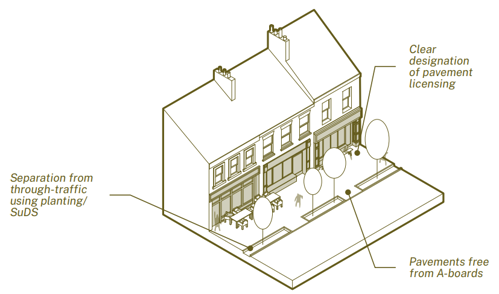
successful high street.
- Clear designation of pavement licensing
- Pavements free from A-boards
- Separation from through-traffic using planting/ SuDS
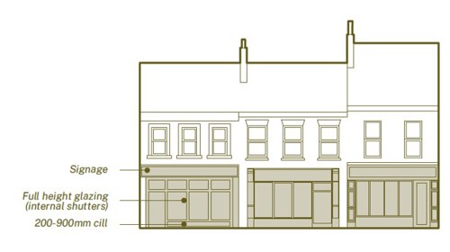
- 200 - 900 mm cill
- Full height glazing (internal shutters)
- Signage
Appendix 1 The Codes
0 Planning and Design Process
Application Type
| Code number | Code | Major residential outline | Major residential full/ reserved matters | Minor residential | Householder | Major non-residential outline | Major non-residential full/ reserved matters | Minor non-residential |
|---|---|---|---|---|---|---|---|---|
| 0.1 | Proposals for major applications must be accompanied by a Design and Access Statement that includes a detailed account of how the proposal has been developed following each of the nine stages of the Planning and Design Process design note. | Yes | Yes | No | No | Yes | Yes | No |
Area Type
| Code number | Code | Urban | Key settlements | Rural | Riverside | High Streets |
|---|---|---|---|---|---|---|
| 0.1 | Proposals for major applications must be accompanied by a Design and Access Statement that includes a detailed account of how the proposal has been developed following each of the nine stages of the Planning and Design Process design note. | Yes | Yes | Yes | Yes | Yes |
1 Street Hierarchy and Servicing
Application Type
| Code number | Code | Major residential outline | Major residential full/ reserved matters | Minor residential | Householder | Major non-residential outline | Major non-residential full/ reserved matters | Minor non-residential |
|---|---|---|---|---|---|---|---|---|
| 1.1 | The spatial characteristics of different street types must be distinctive from one another | Yes | Yes | No | No | Yes | Yes | No |
| 1.2 | Streets proposed as part of a new development must be designed with traffic-calming measures | Yes | Yes | No | No | Yes | Yes | No |
| 1.3 | Street lighting must be present on all new tertiary streets | No | Yes | Yes | No | No | No | No |
| 1.4 | New tertiary streets must have at least one pedestrian priority feature to help encourage slower traffic speeds every 40 metres, or at least one feature where a street is less than 40 metres in length | No | Yes | No | No | No | No | No |
| 1.5 | On-street parking on tertiary streets must be designed as clearly defined parallel and/or chevron bays that are integrated within the street landscape strategy | No | Yes | Yes | No | No | No | No |
| 1.6 | Verges and planting areas that contain street trees must be at least 2 metres wide on tertiary streets | No | Yes | Yes | No | No | Yes | No |
| 1.7 | Street lighting must be present on all new secondary streets |
No | Yes | No | No | No | No | No |
| 1.8 | On secondary streets, pedestrian crossovers located across the mouth of side street junctions must maintain the trajectory of the footpath (desire lines) | No | Yes | No | No | No | No | No |
| 1.9 | New secondary streets must have at least one pedestrian priority feature to help encourage slower traffic speeds every 50 metres, or at least one feature where a street is less than 50 metres in length |
No | Yes | No | No | No | No | No |
| 1.10 | Level footways must be maintained across driveway access points on secondary streets | No | Yes | No | No | No | No | No |
| 1.11 | On-street parking on secondary streets must be integrated within the street landscape strategy | No | Yes | No | No | No | No | No |
| 1.12 | New secondary streets must integrate areas of soft landscaping, including SuDS and tree planting, into the design of the street | No | Yes | No | No | No | No | No |
| 1.13 | Verges and planting areas that contain street trees must be at least 2 metres wide on secondary streets | No | Yes | No | No | No | No | No |
| 1.14 | Main streets must be designed with a clear distinction between vehicular, cycle and pedestrian space | No | Yes | No | No | No | No | No |
| 1.15 | Protected space for cycling must be provided on all new main streets | No | Yes | No | No | No | No | No |
| 1.16 | A main street must not solely provide access to residential uses | No | Yes | No | No | No | No | No |
| 1.17 | Main streets must be designed to accommodate public transport | No | Yes | No | No | No | No | No |
| 1.18 | Street lighting must be present on all new main streets | No | Yes | No | No | No | No | No |
| 1.19 | Pedestrian crossovers with dropped kerbs located across the mouth of side street junctions must maintain the trajectory of the footpath (desire lines) on all new main streets | No | Yes | No | No | No | No | No |
| 1.20 | New main streets must have at least one pedestrian priority feature to help encourage slower traffic speeds every 60 metres | No | Yes | No | No | No | No | No |
| 1.21 | Level footways must be maintained across driveway access points on new main streets | No | Yes | No | No | No | No | No |
| 1.22 | On-street parking on main streets must be designed as clearly defined parallel and/or chevron bays that are integrated within the street landscape strategy | No | Yes | No | No | No | No | No |
| 1.23 | New main streets must integrate areas of soft landscaping, including SuDS and tree planting, into the design of the street | No | Yes | No | No | No | No | No |
| 1.24 | Verges and planting areas that contain street trees must be at least 2 metres wide on main streets | No | Yes | No | No | No | No | No |
| 1.25 | In-curtilage parking located in front of the main building line must be integrated with an area of soft landscape that is equal to or greater than the size of the parking area | No | Yes | Yes | Yes | No | Yes | Yes |
| 1.26 | All parking spaces must have permeable surfaces or be connected to a sustainable urban drainage system | No | Yes | Yes | Yes | No | Yes | Yes |
| 1.27 | Carports must be offset by 1 metre from the highway and garages must be offset by 5.5 metres from the highway and be of sufficient dimensions to allow for the primary purpose of parking a vehicle | No | Yes | Yes | Yes | No | No | No |
| 1.28 | Access to rear parking courtyards must have headroom for resident owned trade vehicles to enter | No | Yes | Yes | No | No | No | No |
| 1.29 | Proposals for private drives must justify why an adopted tertiary street cannot be used instead | No | Yes | Yes | No | No | No | No |
| 1.30 | Private drives must not serve more than 5 dwellings | No | Yes | Yes | No | No | No | No |
| 1.31 | All private drives must have an entry point via a crossover maintaining pedestrian and cycle priority and have a dwelling terminating the view | Yes | Yes | Yes | No | No | No | No |
| 1.32 | In parking squares, bays must be arranged in clusters of up to 5 and integrated with areas of soft landscaping | Yes | Yes | No | No | Yes | Yes | No |
| 1.33 | Rear parking courtyards must be directly overlooked by homes, with street lighting present | No | Yes | Yes | No | No | No | No |
| 1.34 | Neighbourhood-scale parking squares must be enclosed by local facilities on at least three sides (exceptions may be deemed acceptable - see guidance note) | Yes | Yes | No | No | No | No | No |
| 1.35 | All agreed provision of EV charging infrastructure within streets must be designed to ensure pavements are kept clear and accessible | No | Yes | Yes | No | No | Yes | Yes |
| 1.36 | EV charging infrastructure must be provided in shared areas of parking. Level of provision to be agreed with Local Planning Authority and Local Highways Authority | No | Yes | Yes | No | No | Yes | Yes |
| 1.37 | Parking bays reserved for disabled users and car club vehicles must have access priority to building entrances | Yes | Yes | No | No | Yes | Yes | No |
| 1.38 | All new dwellings must be purposely designed with an adequately sized and secure space for the storage of at least one adult sized bicycle | No | Yes | Yes | No | No | No | No |
| 1.39 | Proposals for new properties or use of land must clearly set out waste collection strategies | No | Yes | Yes | No | No | Yes | Yes |
| 1.40 | Bin storage must be enclosed to provide a positive outlook for residents and designed to be robust, secure and ventilated | No | Yes | Yes | No | No | No | No |
Area Type
| Code number | Code | Urban | Key settlements | Rural | Riverside | High Streets |
|---|---|---|---|---|---|---|
| 1.1 | The spatial characteristics of different street types must be distinctive from one another | Yes | Yes | Yes | Yes | No |
| 1.2 | Streets proposed as part of a new development must be designed with traffic-calming measures | Yes | Yes | Yes | Yes | No |
| 1.3 | Street lighting must be present on all new tertiary streets | Yes | Yes | No | Yes | No |
| 1.4 | New tertiary streets must have at least one pedestrian priority feature to help encourage slower traffic speeds every 40 metres, or at least one feature where a street is less than 40 metres in length | Yes | Yes | Yes | Yes | No |
| 1.5 | On-street parking on tertiary streets must be designed as clearly defined parallel and/or chevron bays that are integrated within the street landscape strategy | Yes | Yes | Yes | Yes | No |
| 1.6 | Verges and planting areas that contain street trees must be at least 2 metres wide on tertiary streets | Yes | Yes | Yes | Yes | Yes |
| 1.7 | Street lighting must be present on all new secondary streets | Yes | Yes | Yes | Yes | No |
| 1.8 | On secondary streets, pedestrian crossovers located across the mouth of side street junctions must maintain the trajectory of the footpath (desire lines) | Yes | Yes | Yes | Yes | No |
| 1.9 | New secondary streets must have at least one pedestrian priority feature to help encourage slower traffic speeds every 50 metres, or at least one feature where a street is less than 50 metres in length | Yes | Yes | Yes | Yes | No |
| 1.10 | Level footways must be maintained across driveway access points on secondary streets | Yes | Yes | Yes | Yes | No |
| 1.11 | On-street parking on secondary streets must be integrated within the street landscape strategy | Yes | Yes | Yes | Yes | No |
| 1.12 | New secondary streets must integrate areas of soft landscaping, including SuDS and tree planting, into the design of the street | Yes | Yes | Yes | Yes | No |
| 1.13 | Verges and planting areas that contain street trees must be at least 2 metres wide on secondary streets | Yes | Yes | Yes | Yes | No |
| 1.14 | Main streets must be designed with a clear distinction between vehicular, cycle and pedestrian space | Yes | Yes | No | No | No |
| 1.15 | Protected space for cycling must be provided on all new main streets | Yes | Yes | No | No | No |
| 1.16 | A main street must not solely provide access to residential uses | Yes | Yes | No | No | No |
| 1.17 | Main streets must be designed to accommodate public transport | Yes | Yes | No | No | No |
| 1.18 | Street lighting must be present on all new main streets | Yes | Yes | No | No | No |
| 1.19 | Pedestrian crossovers with dropped kerbs located across the mouth of side street junctions must maintain the trajectory of the footpath (desire lines) on all new main streets | Yes | Yes | No | No | No |
| 1.20 | New main streets must have at least one pedestrian priority feature to help encourage slower traffic speeds every 60 metres | Yes | Yes | No | No | No |
| 1.21 | Level footways must be maintained across driveway access points on new main streets | Yes | Yes | No | No | No |
| 1.22 | On-street parking on main streets must be designed as clearly defined parallel and/or chevron bays that are integrated within the street landscape strategy | Yes | Yes | No | No | No |
| 1.23 | New main streets must integrate areas of soft landscaping, including SuDS and tree planting, into the design of the street | Yes | Yes | No | No | No |
| 1.24 | Verges and planting areas that contain street trees must be at least 2 metres wide on main streets | Yes | Yes | No | No | No |
| 1.25 | In-curtilage parking located in front of the main building line must be integrated with an area of soft landscape that is equal to or greater than the size of the parking area | Yes | Yes | Yes | Yes | No |
| 1.26 | All parking spaces must have permeable surfaces or be connected to a sustainable urban drainage system | Yes | Yes | Yes | Yes | Yes |
| 1.27 | Carports must be offset by 1 metre from the highway and garages must be offset by 5.5 metres from the highway and be of sufficient dimensions to allow for the primary purpose of parking a vehicle | Yes | Yes | Yes | Yes | No |
| 1.28 | Access to rear parking courtyards must have headroom for resident owned trade vehicles to enter | Yes | Yes | Yes | Yes | No |
| 1.29 | Proposals for private drives must justify why an adopted tertiary street cannot be used instead | Yes | Yes | Yes | Yes | No |
| 1.30 | Private drives must not serve more than 5 dwellings | Yes | Yes | Yes | Yes | No |
| 1.31 | All private drives must have an entry point via a crossover maintaining pedestrian and cycle priority and have a dwelling terminating the view | Yes | Yes | Yes | Yes | No |
| 1.32 | In parking squares, bays must be arranged in clusters of up to 5 and integrated with areas of soft landscaping | Yes | Yes | Yes | Yes | Yes |
| 1.33 | Rear parking courtyards must be directly overlooked by homes, with street lighting present | Yes | Yes | Yes | Yes | No |
| 1.34 | Neighbourhood-scale parking squares must be enclosed by local facilities on at least three sides (exceptions may be deemed acceptable - see guidance note) | Yes | Yes | Yes | Yes | No |
| 1.35 | All agreed provision of EV charging infrastructure within streets must be designed to ensure pavements are kept clear and accessible | Yes | Yes | Yes | Yes | Yes |
| 1.36 | EV charging infrastructure must be provided in shared areas of parking. Level of provision to be agreed with Local Planning Authority and Local Highways Authority | Yes | Yes | Yes | Yes | Yes |
| 1.37 | Parking bays reserved for disabled users and car club vehicles must have access priority to building entrances | Yes | Yes | Yes | Yes | Yes |
| 1.38 | All new dwellings must be purposely designed with an adequately sized and secure space for the storage of at least one adult sized bicycle | Yes | Yes | Yes | Yes | No |
| 1.39 | Proposals for new properties or use of land must clearly set out waste collection strategies | Yes | Yes | Yes | Yes | Yes |
| 1.40 | Bin storage must be enclosed to provide a positive outlook for residents and designed to be robust, secure and ventilated | Yes | Yes | Yes | Yes | No |
2 infill and Intensification
Application Type
| Code number | Code | Major residential outline | Major residential full/ reserved matters | Minor residential | Householder | Major non-residential outline | Major non-residential full/ reserved matters | Minor non-residential |
|---|---|---|---|---|---|---|---|---|
| 2.1 | Proposals must have regard for: 1. the relevant Area Type vision and 2. Area type worksheets in the design code Baseline Appraisal taking into account development pattern of the local area including building lines, plot structure and grain. | No | Yes | Yes | Yes | No | Yes | Yes |
| 2.2 | The scale and massing of new development in backland sites must not exceed that of surrounding existing buildings. | No | Yes | Yes | No | No | Yes | Yes |
| 2.3 | Gates across the entrance routes into backland development will not be permitted | No | Yes | Yes | No | No | Yes | Yes |
| 2.4 | In new development buildings on corner plots must respond to their double frontage with no blank elevations facing a street at ground floor level | No | Yes | Yes | Yes | No | Yes | Yes |
Area Type
| Code number | Code | Urban | Key settlements | Rural | Riverside | High Streets |
|---|---|---|---|---|---|---|
| 2.1 | Proposals must have regard for: 1. the relevant Area Type vision and 2. Area type worksheets in the design code Baseline Appraisal taking into account development pattern of the local area including building lines, plot structure and grain. | Yes | Yes | Yes | Yes | Yes |
| 2.2 | The scale and massing of new development in backland sites must not exceed that of surrounding existing buildings. | Yes | Yes | Yes | Yes | No |
| 2.3 | Gates across the entrance routes into backland development will not be permitted | Yes | Yes | Yes | Yes | No |
| 2.4 | In new development buildings on corner plots must respond to their double frontage with no blank elevations facing a street at ground floor level | Yes | Yes | Yes | Yes | Yes |
3 Multi-dwellings and Taller Buildings
Application Type
| Code number | Code | Major residential outline | Major residential full/ reserved matters | Minor residential | Householder | Major non-residential outline | Major non-residential full/ reserved matters | Minor non-residential |
|---|---|---|---|---|---|---|---|---|
| 3.1 | New multi-dwellings and taller buildings must be dual aspect. Single aspect, north facing apartments will not be accepted unless it can be demonstrated that the adaptation of an existing building prevents it |
No | Yes | Yes | No | No | No | No |
| 3.2 | Balconies must be a min. 1500mm deep of clear external space and free from obstruction. Any privacy screens must be integral to the design | No | Yes | Yes | Yes | No | No | No |
| 3.3 | Windows must have a minimum reveal depth of 150mm in all new developments | No | Yes | Yes | No | No | Yes | Yes |
| 3.4 | Meter boxes must not be located on primary elevations | No | Yes | Yes | No | No | No | No |
| 3.5 | Mitigation measures such as tree planting designed to reduce wind speeds must be provided and managed on-curtilage of the development site in perpetuity. Trees associated with wind mitigation will not be accepted in the carriageway |
No | Yes | No | No | No | Yes | No |
| 3.6 | Applications for purpose built accommodation (PBSA) must be able to demonstrate that the development will be able to adapt to self-contained residential apartments | No | Yes | No | No | No | No | No |
Area Type
| Code number | Code | Urban | Key settlements | Rural | Riverside | High Streets |
|---|---|---|---|---|---|---|
| 3.1 | New multi-dwellings and taller buildings must be dual aspect. Single aspect, north facing apartments will not be accepted unless it can be demonstrated that the adaptation of an existing building prevents it | Yes | Yes | No | Yes | No |
| 3.2 | Balconies must be a min. 1500mm deep of clear external space and free from obstruction. Any privacy screens must be integral to the design | Yes | Yes | No | Yes | No |
| 3.3 | Windows must have a minimum reveal depth of 150mm in all new developments | Yes | Yes | No | Yes | No |
| 3.4 | Meter boxes must not be located on primary elevations | Yes | Yes | No | Yes | No |
| 3.5 | Mitigation measures such as tree planting designed to reduce wind speeds must be provided and managed on-curtilage of the development site in perpetuity. Trees associated with wind mitigation will not be accepted in the carriageway | Yes | Yes | No | Yes | No |
| 3.6 | Applications for purpose built accommodation (PBSA) must be able to demonstrate that the development will be able to adapt to self-contained residential apartments | Yes | Yes | No | Yes | No |
4 Landscape
Application Type
| Code number | Code | Major residential outline | Major residential full/ reserved matters | Minor residential | Householder | Major non-residential outline | Major non-residential full/ reserved matters | Minor non-residential |
|---|---|---|---|---|---|---|---|---|
| 4.1 | SuDS features must be designed as part of a coordinated system of strategic blue infrastructure, for example, overflowing into urban wetlands and natural water courses | Yes | Yes | Yes | No | Yes | Yes | Yes |
| 4.2 | SuDS features must incorporate resilient planting suitable to wet and dry conditions | No | Yes | Yes | No | No | Yes | Yes |
| 4.3 | Management and maintenance plans must be provided for all new SuDS features | No | Yes | Yes | No | No | Yes | Yes |
| 4.4 | All new homes with gardens, planting areas and/or access to communal planting must be fitted with water butts of a minimum 200 litre capacity | No | Yes | Yes | No | No | No | No |
| 4.5 | Dry detention ponds must not be part of proposed SuDS features outside of the East Midlands Airport Safeguarded Area | Yes | Yes | Yes | No | Yes | Yes | Yes |
| 4.6 | A minimum of two swift bricks per dwelling must be provided in new residential development in addition to any other ecological enhancements (including BNG) |
No | Yes | Yes | No | No | No | No |
| 4.7 | A minimum of three swift bricks or suitable alternative must be installed per unit for commercial and industrial development in addition to any other ecological enhancements (including BNG) |
No | No | No | No | No | Yes | Yes |
| 4.8 | Robust boundary materials (including ‘internal’ fences) must be fitted with hedgehog holes in addition to any other ecological enhancements (including BNG) |
No | Yes | Yes | Yes | No | Yes | Yes |
| 4.9 | New development must not specify the use of plastic planting or artificial grass | No | Yes | Yes | Yes | No | Yes | Yes |
| 4.10 | Multi-functional green infrastructure must be incorporated into new development | Yes | Yes | No | No | Yes | Yes | No |
| 4.11 | New green infrastructure features must connect to existing strategic and local green infrastructure | Yes | Yes | No | No | Yes | Yes | No |
| 4.12 | Proposals for green infrastructure must include a management plan for the lifetime of the development | No | Yes | No | No | No | Yes | No |
| 4.13 | A minimum of one new tree per one parking space provided in the development (including garage spaces) must be planted in the public realm |
No | Yes | No | No | No | Yes | No |
| 4.14 | Trees planted within a hard landscape must utilise a soil structure system to create an uncompacted root zone and reduce the risk of roots lifting surfaces | No | Yes | No | No | No | Yes | No |
| 4.15 | Public realm design proposals must be informed by an analysis of anticipated (in the case of proposed new public realm) movement patterns by users through and within the space, including desire lines. | No | Yes | No | No | No | Yes | No |
| 4.16 | Level access must be provided to all areas of public realm within new development. Where changes of level are required they must be considered in terms of how they promote or restrict access and be clearly communicated. | No | Yes | No | No | No | Yes | No |
| 4.17 | Play spaces must be located to create a balance of provision across new developments | Yes | Yes | No | No | No | No | No |
| 4.18 | Play spaces must be located where they have direct links to walking and cycle routes so that children and young people can reach them safely and easily |
Yes | Yes | No | No | No | No | No |
| 4.19 | Management and maintenance plans must be provided for all proposed play spaces | No | Yes | No | No | No | No | No |
| 4.20 | In new residential development communal facilities must be located where they have direct links to walking and cycle routes so that residents can reach them safely and easily on foot or by wheel | Yes | Yes | No | No | No | No | No |
| 4.21 | Proposals for new development must demonstrate that they provide for clear and easy movement through and within the development | Yes | Yes | No | No | No | No | No |
| 4.22 | Proposals for new residential development must provide a well-connected street network within the development and enable connections beyond the site boundary | Yes | Yes | No | No | No | No | No |
| 4.23 | Major new development must provide integrated active travel routes as part of a safe, attractive and coherent network | Yes | Yes | No | No | Yes | Yes | No |
| 4.24 | Walking and cycling routes must be lit to increase safety and accessibility and designed appropriately for their setting and context | No | Yes | No | No | No | Yes | No |
| 4.25 | Management plans must highlight areas of landscape, SuDS and play areas for adoption with information on layout, materials, construction details and soft landscaping | No | Yes | No | No | No | Yes | No |
| 4.26 |
Management plans must indicate:
|
No | Yes | No | No | No | Yes | No |
| 4.27 | Management plans must promote and encourage cleanliness | No | Yes | No | No | No | Yes | No |
| 4.28 | Management plans must ensure the successful establishment and continued thriving of all plants and trees, and replacement of all dead or dying trees/plants for a period of 5 years | No | Yes | No | No | No | Yes | No |
| 4.29 | Developers must create a Habitat Management and Monitoring Plan (HMMP), employing strategies that encourage biodiversity as per section 4.2 Biodiversity. | No | Yes | No | No | No | Yes | No |
| 4.30 | Management plans must outline the goals and purposes of different landscape elements (sections 4.1, 4.2, 4.3, 4.4, 4.5, 4.6) and describe the strategies to be implemented for their achievement | No | Yes | No | No | No | Yes | No |
Area Type
| Code number | Code | Urban | Key settlements | Rural | Riverside | High Streets |
|---|---|---|---|---|---|---|
| 4.1 | SuDS features must be designed as part of a coordinated system of strategic blue infrastructure, for example, overflowing into urban wetlands and natural water courses | Yes | Yes | Yes | Yes | No |
| 4.2 | SuDS features must incorporate resilient planting suitable to wet and dry conditions | Yes | Yes | Yes | Yes | Yes |
| 4.3 | Management and maintenance plans must be provided for all new SuDS features | Yes | Yes | Yes | Yes | Yes |
| 4.4 | All new homes with gardens, planting areas and/or access to communal planting must be fitted with water butts of a minimum 200 litre capacity | Yes | Yes | Yes | Yes | No |
| 4.5 | Dry detention ponds must not be part of proposed SuDS features outside of the East Midlands Airport Safeguarded Area | Yes | Yes | Yes | Yes | No |
| 4.6 | A minimum of two swift bricks per dwelling must be provided in new residential development in addition to any other ecological enhancements (including BNG) | Yes | Yes | Yes | Yes | No |
| 4.7 | A minimum of three swift bricks or suitable alternative must be installed per unit for commercial and industrial development in addition to any other ecological enhancements (including BNG) | Yes | Yes | Yes | Yes | No |
| 4.8 | Robust boundary materials (including ‘internal’ fences) must be fitted with hedgehog holes in addition to any other ecological enhancements (including BNG) | Yes | Yes | Yes | Yes | No |
| 4.9 | New development must not specify the use of plastic planting or artificial grass | Yes | Yes | Yes | Yes | No |
| 4.10 | Multi-functional green infrastructure must be incorporated into new development | Yes | Yes | Yes | Yes | No |
| 4.11 | New green infrastructure features must connect to existing strategic and local green infrastructure | Yes | Yes | Yes | Yes | No |
| 4.12 | Proposals for green infrastructure must include a management plan for the lifetime of the development | Yes | Yes | Yes | Yes | No |
| 4.13 | A minimum of one new tree per one parking space provided in the development (including garage spaces) must be planted in the public realm | Yes | Yes | Yes | Yes | No |
| 4.14 | Trees planted within a hard landscape must utilise a soil structure system to create an uncompacted root zone and reduce the risk of roots lifting surfaces | Yes | Yes | Yes | Yes | Yes |
| 4.15 | Public realm design proposals must be informed by an analysis of anticipated (in the case of proposed new public realm) movement patterns by users through and within the space, including desire lines. | Yes | Yes | Yes | Yes | Yes |
| 4.16 | Level access must be provided to all areas of public realm within new development. Where changes of level are required they must be considered in terms of how they promote or restrict access and be clearly communicated | Yes | Yes | Yes | Yes | Yes |
| 4.17 | Play spaces must be located to create a balance of provision across new developments | Yes | Yes | Yes | Yes | No |
| 4.18 | Play spaces must be located where they have direct links to walking and cycle routes so that children and young people can reach them safely and easily | Yes | Yes | Yes | Yes | No |
| 4.19 | Management and maintenance plans must be provided for all proposed play spaces | Yes | Yes | Yes | Yes | No |
| 4.20 | In new residential development communal facilities must be located where they have direct links to walking and cycle routes so that residents can reach them safely and easily on foot or by wheel | Yes | Yes | Yes | Yes | No |
| 4.21 | Proposals for new development must demonstrate that they provide for clear and easy movement through and within the development | Yes | Yes | Yes | Yes | No |
| 4.22 | Proposals for new residential development must provide a well-connected street network within the development and enable connections beyond the site boundary | Yes | Yes | Yes | Yes | No |
| 4.23 | Major new development must provide integrated active travel routes as part of a safe, attractive and coherent network | Yes | Yes | Yes | Yes | No |
| 4.24 | Walking and cycling routes must be lit to increase safety and accessibility and designed appropriately for their setting and context | Yes | Yes | Yes | Yes | Yes |
| 4.25 | Management plans must highlight areas of landscape, SuDS and play areas for adoption with information on layout, materials, construction details and soft landscaping | Yes | Yes | Yes | Yes | No |
| 4.26 |
Management plans must indicate:
|
Yes | Yes | Yes | Yes | No |
| 4.27 | Management plans must promote and encourage cleanliness | Yes | Yes | Yes | Yes | No |
| 4.28 | Management plans must ensure the successful establishment and continued thriving of all plants and trees, and replacement of all dead or dying trees/plants for a period of 5 years | Yes | Yes | Yes | Yes | No |
| 4.29 | Developers must create a Habitat Management and Monitoring Plan (HMMP), employing strategies that encourage biodiversity as per section 4.2 Biodiversity. | Yes | Yes | Yes | Yes | No |
| 4.30 | Management plans must outline the goals and purposes of different landscape elements (sections 4.1, 4.2, 4.3, 4.4, 4.5, 4.6) and describe the strategies to be implemented for their achievement | Yes | Yes | Yes | Yes | No |
5 Householder
Application Type
| Code number | Code | Major residential outline | Major residential full/ reserved matters | Minor residential | Householder | Major non-residential outline | Major non-residential full/ reserved matters | Minor non-residential |
|---|---|---|---|---|---|---|---|---|
| 5.1 | Side extensions must not result in development within 1 metre of a common boundary with a neighbouring house or where terracing would result | No | No | No | Yes | No | No | No |
| 5.2 | Where there is a consistent rhythm to the street scene, in terms of setbacks, heights, separation distances and materials palette, this must not be interrupted. | No | No | No | Yes | No | No | No |
| 5.3 | Extensions must not result in blank gables to the public realm. There must always be a minimum of one window from a habitable room at ground floor level | No | No | No | Yes | No | No | No |
| 5.4 | Dormers on front elevations will only be accepted where there is an existing historic precedent of dormers on the front elevation in the vicinity and the proposed dormers follow the existing proportions | No | No | No | Yes | No | No | No |
| 5.5 | Dormers must be inset by a minimum 500 mm from party walls, eaves and ridges unless justified in a Heritage Impact Assessment | No | No | No | Yes | No | No | No |
| 5.6 | Dormer extensions on side elevations will not be accepted | No | No | No | Yes | No | No | No |
| 5.7 | New development should not overshadow neighbouring roof mounted renewable energy installations | No | No | No | Yes | No | No | No |
| 5.8 | All front and rear gardens must include at least 50% natural grass, planting and other forms of living vegetation | No | No | No | Yes | No | No | No |
| 5.9 | Proposals to enclose gardens facing the public realm must off-set boundary treatments by 1 metre from the highway and be screened by soft landscaping | No | No | No | Yes | No | No | No |
| 5.10 | Raised platforms in rear gardens must be installed with privacy screens where required | No | No | No | Yes | No | No | No |
Area Type
| Code number | Code | Urban | Key settlements | Rural | Riverside | High Streets |
|---|---|---|---|---|---|---|
| 5.1 | Side extensions must not result in development within 1 metre of a common boundary with a neighbouring house or where terracing would result |
Yes | Yes | Yes | Yes | No |
| 5.2 | Where there is a consistent rhythm to the street scene, in terms of setbacks, heights, separation distances and materials palette, this must not be interrupted. | Yes | Yes | Yes | Yes | No |
| 5.3 | Extensions must not result in blank gables to the public realm. There must always be a minimum of one window from a habitable room at ground floor level | Yes | Yes | Yes | Yes | No |
| 5.4 | Dormers on front elevations will only be accepted where there is an existing historic precedent of dormers on the front elevation in the vicinity and the proposed dormers follow the existing proportions | Yes | Yes | Yes | Yes | No |
| 5.5 | Dormers must be inset by a minimum 500 mm from party walls, eaves and ridges unless justified in a Heritage Impact Assessment | Yes | Yes | Yes | Yes | No |
| 5.6 | Dormer extensions on side elevations will not be accepted | Yes | Yes | Yes | Yes | No |
| 5.7 | New development should not overshadow neighbouring roof mounted renewable energy installations | Yes | Yes | Yes | Yes | No |
| 5.8 | All front and rear gardens must include at least 50% natural grass, planting and other forms of living vegetation | Yes | Yes | Yes | Yes | No |
| 5.9 | Proposals to enclose gardens facing the public realm must off-set boundary treatments by 1 metre from the highway and be screened by soft landscaping | Yes | Yes | Yes | Yes | No |
| 5.10 | Raised platforms in rear gardens must be installed with privacy screens where required | Yes | Yes | Yes | Yes | No |
6 Rural
Application Type
| Code number | Code | Major residential outline | Major residential full/ reserved matters | Minor residential | Householder | Major non-residential outline | Major non-residential full/ reserved matters | Minor non-residential |
|---|---|---|---|---|---|---|---|---|
| 6.1 | When converting a traditional rural building, the original openings in the external elevations must be retained | No | Yes | Yes | No | No | Yes | Yes |
| 6.2 | New masonry chimneys will not be acceptable when converting traditional rural buildings | No | Yes | Yes | No | No | Yes | Yes |
| 6.3 | Dormer windows will not be acceptable when converting traditional rural buildings | No | Yes | Yes | No | No | Yes | Yes |
| 6.4 | New porches will not be acceptable when converting traditional rural buildings | No | Yes | Yes | No | No | Yes | Yes |
| 6.5 | Where existing traditional rural buildings have a strong and established linear form, alterations as part of a conversion scheme must reflect that linear form | No | Yes | Yes | No | No | Yes | Yes |
| 6.6 | Replacement dwellings in the open countryside or Green Belt must not exceed by more than 50% the volume of the original building, including outbuildings within 5 metres of the host dwelling | No | Yes | Yes | No | No | No | No |
| 6.7 | Extensions within the open countryside or Green Belt must not increase the size of the dwelling by more than 50% of the volume of the original building |
No | Yes | Yes | Yes | No | No | No |
| 6.8 | Applications for more than four small stables and one storage area for tack, hay, animal feed and so forth in one given location are not acceptable, unless supported by an existing business case | No | No | No | No | No | Yes | Yes |
| 6.9 | Stables must not be located on an exposed skyline | No | No | No | No | No | Yes | Yes |
| 6.10 | Tack rooms and hay stores must be integral to a stable block and be of a size similar to a small stable | No | No | No | No | No | Yes | Yes |
| 6.11 | Muckheaps must not be sited where they will contaminate watercourses, cause nuisance to public rights of way or adjacent to dwellings | No | No | No | No | No | Yes | Yes |
| 6.12 | Exercise areas/menages must be constructed with visually unobtrusive surface materials. Bark or recycled chippings are acceptable | No | No | No | No | No | Yes | Yes |
| 6.13 | Bituminous macadam must not be used for hardstanding areas | No | No | No | No | No | Yes | Yes |
Area Type
| Code number | Code | Urban | Key settlements | Rural | Riverside | High Streets |
|---|---|---|---|---|---|---|
| 6.1 | When converting a traditional rural building, the original openings in the external elevations must be retained | No | No | Yes | No | No |
| 6.2 | New masonry chimneys will not be acceptable when converting traditional rural buildings | No | No | Yes | No | No |
| 6.3 | Dormer windows will not be acceptable when converting traditional rural buildings | No | No | Yes | No | No |
| 6.4 | New porches will not be acceptable when converting traditional rural buildings | No | No | Yes | No | No |
| 6.5 | Where existing traditional rural buildings have a strong and established linear form, alterations as part of a conversion scheme must reflect that linear form | No | No | Yes | No | No |
| 6.6 | Replacement dwellings in the open countryside or Green Belt must not exceed by more than 50% the volume of the original building, including outbuildings within 5 metres of the host dwelling | No | No | Yes | No | No |
| 6.7 | Extensions within the open countryside or Green Belt must not increase the size of the dwelling by more than 50% of the volume of the original building | No | No | Yes | No | No |
| 6.8 | Applications for more than four small stables and one storage area for tack, hay, animal feed and so forth in one given location are not acceptable, unless supported by an existing business case | No | No | Yes | No | No |
| 6.9 | Stables must not be located on an exposed skyline | No | No | Yes | No | No |
| 6.10 | Tack rooms and hay stores must be integral to a stable block and be of a size similar to a small stable | No | No | Yes | No | No |
| 6.11 | Muckheaps must not be sited where they will contaminate watercourses, cause nuisance to public rights of way or adjacent to dwellings | No | No | Yes | No | No |
| 6.12 | Exercise areas/menages must be constructed with visually unobtrusive surface materials. Bark or recycled chippings are acceptable | No | No | Yes | No | No |
| 6.13 | Bituminous macadam must not be used for hardstanding areas | No | No | Yes | No | No |
7 High Streets and Retail
Application Type
| Code number | Code | Major residential outline | Major residential full/ reserved matters | Minor residential | Householder | Major non-residential outline | Major non-residential full/ reserved matters | Minor non-residential |
|---|---|---|---|---|---|---|---|---|
| 7.1 | Developments on High Streets must include active ground floor uses | No | No | No | No | No | Yes | Yes |
| 7.2 | Developments on High Streets must orientate buildings to face the street, with their main entrances located on the street frontage | No | No | No | No | No | Yes | Yes |
| 7.3 | Shopfronts must be in keeping with the design of the host building | No | No | No | No | No | Yes | Yes |
| 7.4 | A stallriser between 0.2-0.9 metres in height must be included within the elevation of shop frontages | No | No | No | No | No | Yes | Yes |
| 7.5 | New frontages must include legible and level door access | No | No | No | No | No | Yes | Yes |
| 7.6 | In Conservation Areas traditional features must be included in new and replacement shop fronts (see illustrations), except where it would conflict with C7.3 | No | No | No | No | No | Yes | Yes |
| 7.7 | Internal shutters will be acceptable. External shutters are not acceptable | No | No | No | No | No | Yes | Yes |
Area Type
| Code number | Code | Urban | Key settlements | Rural | Riverside | High Streets |
|---|---|---|---|---|---|---|
| 7.1 | Developments on High Streets must include active ground floor uses | No | No | No | No | Yes |
| 7.2 | Developments on High Streets must orientate buildings to face the street, with their main entrances located on the street frontage | No | No | No | No | Yes |
| 7.3 | Shopfronts must be in keeping with the design of the host building | Yes | Yes | Yes | Yes | Yes |
| 7.4 | A stallriser between 0.2-0.9 metres in height must be included within the elevation of shop frontages | Yes | Yes | Yes | Yes | Yes |
| 7.5 | New frontages must include legible and level door access | Yes | Yes | Yes | Yes | Yes |
| 7.6 | In Conservation Areas traditional features must be included in new and replacement shop fronts (see illustrations), except where it would conflict with C7.3 | No | Yes | Yes | No | No |
| 7.7 | Internal shutters will be acceptable. External shutters are not acceptable | Yes | Yes | Yes | Yes | Yes |
Appendix 2 Glossary of Terms
Accessibility means that people can do what they need to do in a similar amount of time and effort as someone that does not have a
disability.
Active travel means getting about in a way that makes you physically active, like walking or cycling.
Air Source Heat Pump (ASHP) is a type of low carbon heating source. It transfers heat from the outside air to water, heat from the air is absorbed into a fluid. This fluid then passes through a heat exchanger into the heat pump which raises the temperature and then transfers that heat to water, which heats yours rooms via radiators or underfloor heating.
Amenity relates to the pleasantness or attractiveness of a place. Householder planning applications are assessed on visual amenity (the aesthetics of the proposal) and residential amenity (the impact on neighbours’ outlook, privacy and access to light).
Bay window is a window which projects outward from the main walls of the building, forming a bay in a room.
Biodiversity Net Gain (BNG) is an approach to development. It makes sure that habitats for wildlife are left in a measurably better state than they were before the development. Developers must deliver a BNG of 20%. This means a development will result in more or better quality natural habitat than there was before development.
Blue infrastructure is a network of water-based features that provide ecological, social, and economic benefits.
Building line is an established line on a street created by the placement of buildings in uniform alignment: an extension which would project across this line may be harmful to local character, interrupting the uniformity of the street.
Building Regulations are a set of statutory approved documents which set out national minimum standards for specific aspects of building design and construction.
Canopy is an overhead roof structure with open sides, used to provide shelter from rain immediately outside the entrance of a building, or to add decoration to a building.
Certificate of Lawfulness is a certificate issued by a Local Planning Authority to confirm that any specified use or development of land is lawful (also known as a Lawful Development Certificate) Character is the distinctively recognisable nature of a building or place.
Classified road is a road which is classified in accordance with section 12 of the Highways Act 1980 due to national, regional or local importance as a main thoroughfare. Numbered roads are signed as M (Motorway), A- or B-roads, and there are some classified unnumbered roads (sometimes known as C-roads). Smaller local roads are unclassified.
Conditions are planning conditions imposed on a grant of planning permission, requiring additional approvals for specific aspects of the development or restricting the way in which the site is used to make the proposed development acceptable in planning terms.
Canopy cover is the area of the ground covered by the leaves, branches, and stems of trees or shrubs as viewed from above. Clear path width is the surface area conventionally described as the carriageway. In the case of some tertiary streets this part of the street may be shared by all users.
Enclosure is defined by the width of a street relative to the height of buildings at their edges. For example, where a street width is twice the height of the buildings this is expressed as a ratio 1:2.
Footpath parking is where people park their vehicles partially or wholly on spaces intended for pedestrians only.
Flood attenuation is the process of reducing the intensity and duration of flooding by storing and releasing water at a controlled rate.
Homezones are streets where people and vehicles share the whole of the street space safely and on equal terms, where quality of life takes precedence over ease of traffic movement. Vehicle speeds are reduced to walking pace.
Inclusivity is the fact of including all types of people, things or ideas and treating them all fairly and equally.
Legibility means the extent to which a place is recognisable and coherently organised. A legible layout contributes to identity, improves distinctiveness, and enables clear, memorable images of place.
Landscape Management and Maintenance Plan (LEMP) sets out how a particular development will maintain the retained landscape and existing ecology of the site. It should include plans to ensure the designed landscape fulfils its roles, including providing habitats and recreational space.
Local Biodiversity Action Plan (LBAP) is a comprehensive strategy designed by communities of local authorities to safeguard the biodiversity of a specific region.
Management Plan - A Landscape Management and Maintenance Plan outlines the strategies for preserving the existing ecology and maintaining the landscaped areas within a development. This comprehensive document encompasses measures to ensure that the planned landscape functions effectively, serving purposes such as creating habitats and offering recreational zones. Mono-pitch roof is a single-sloped roof surface which slopes from one side of a building, or building element, to another (also known as a lean-to roof).
National Design Guide is a UK Government publication which illustrates how to achieve well-designed places.
Notification for Prior Approval is a process of informing the Local Planning Authority of intentions to exercise certain permitted development rights prior to the development taking place, sometimes taking the form of a fast-track planning process.
Obscure glazing is glass used in windows and doors which cannot be seen through in order to protect privacy, such as frosted or patterned glass. Obscurity is measured on a scale of 1 to 5, where 1 offers very low levels of privacy and 5 offers very high levels of privacy. Level 3 will normally be the minimum expected when obscure glazing is requested to mitigate privacy issues.
Offshoot is a protruding section of a dwelling, common in terraced houses which extends into the rear garden or yard on one side of the property, often housing a kitchen and/or bathroom.
Original building is defined as the dwelling as it was first built, or as it stood on 1st July 1948 if the structure was first constructed before 1948.
Outlook is the external space that can be viewed from a habitable window, which is protected by planning controls to prevent a sense of excessive enclosure or loss of openness: this is different to a view, which is related to a specific object or scene visible from the window, and which is not protected by planning controls.
Overdevelopment is defined as a quantity of built form or intensity of use on a particular site which is excessive in terms of its impact on local amenity and character.
Pedestrian priority interventions are features such buildouts of landscape and street trees, visual narrowing, controlled and uncontrolled pedestrian crossings.
Private drive is an access street or driveway that has not been designed to adoptable standards.
Party Wall Act is a legal framework for preventing and resolving disputes in relation to party walls, property boundaries and excavations near neighbouring buildings: these disputes are not relevant to planning processes or decisions.
Permeable surface is where a material allows liquids or gases to pass through it or in-between, such as permeable paving which allows natural drainage
Permitted Development A type of development covered by the General Permitted Development Order, which can be carried out without planning permission.
Rain gardens are relatively small, planted areas designed to receive rainwater flowing from paved surfaces or from drainpipes. Rain gardens are designed to intercept and slow the flow of water that might otherwise directly enter conventional drains.
Resilient trees and planting can survive and thrive in the face of climate change and other environmental pressures.
Rainwater harvesting A technique of collection and storage of rainwater for re-use on-site rather than allowing it to run off.
Rooflight is a window built into a roof to admit light and ventilation (also known as a skylight).
Segregation sandwich is a publicly accessible route through the centre of two parallel private drives and or adopted vehicle surfaces, often physically segregated and contained by fencing.
Surface run-off is where water that flows over the surface of the ground instead of being absorbed by the soil.
Sustainable Drainage Systems (SuDS) are a a collection of water management practices that aim to align modern drainage systems with natural water processes as part of a larger green infrastructure strategy.
Section drawing is a 2D drawing which shows a view of a building or structure as though it had been sliced in half or cut along another imaginary plane (usually a vertical plane).
Street scene is the appearance and character of an area (usually a linear street) created by the form of buildings and open spaces, relating to the massing and scale of building but also to floorspace and street furniture details.
Subservient Where a certain part of the building (generally an extension) appears less important or prominent than the rest of the building due to its massing, placement or materials.
Terracing effect is a term used to describe the closing of gaps between houses by extending the houses sideways, thus giving the appearance of a continuous building mass.
Thermal transmittance Is a measurement of how well a building element, such as a wall, roof, or floor, resists heat loss. It's sometime referred to as a u-value and expressed in units of W/m²K, which represents the rate of heat flow through 1 square meter of
a structure with a temperature difference of 1 degree. A lower U-value indicates better insulation, and is important because Building
Regulations set maximum permitted U-values for each element.
Topography is the shape and features of land surfaces, such as slopes, hills and mountains.
Townscape The appearance of an urban area; an urban landscape.
Tree Preservation Order (TPO) An order made by a Local Planning Authority to protect a specific tree or group of trees.
Walkability helps to connect communities and provide alternatives to driving.
Appendix 3 Area Type Geographies
- The Urban (West Bridgford) area type covers the main urban area of Nottingham (within Rushcliffe) and that land situated within the inner boundary of the Green Belt, excluding the land covered by the Riverside area type and those areas covered by the Strategic Allocation South of Clifton and Strategic Allocation East of Gamston/North of Tollerton. The Urban Area type would also apply to any development proposals within Rushcliffe that would expand the built extent of the main urban area of Nottingham.
- The detailed boundaries of the Riverside area type are as illustrated below.
- The Key Settlement area type includes the settlements of Bingham, Cotgrave, East Leake, Keyworth, Radcliffe on Trent and Ruddington. It applies to land within the existing built extent of each settlement and also in respect of development proposals that would expand the built extent of the settlement.
- The High Streets area type includes the designated District Centres at Bingham and West Bridgford and the Local Centres at Cotgrave, East Leake, Keyworth (The Square), Keyworth (Wolds Drive), Radcliffe on Trent and Ruddington. These are designed by the Rushcliffe Local Plan and defined on the Rushcliffe Local Plan Policies Map.
- The Rural area type covers all other land within Rushcliffe not covered by the above area types.

Key
Red line - Rushcliffe Borough boundary
Blue - Urban
Orange - Riverside
Yellow - High streets
Cream - Rural
Accessible Documents
- Air Quality Action Plan 2021
- Annual Air Quality Reports
- Air Quality Strategy for Nottingham and Notts
- Annual Governance Statement 2023-24
- Annual Governance Statement 2021-22
- Annual Governance Statement 2020-21
- Asset Management Strategy
- Auditor's Annual Report 2021
- Internal Audit Annual Report 2021/22
- Auditor's Annual Report 2021-22
- Become a Councillor 2022
- Budget and Financial Strategy
- Capital and Investment Strategy
- Climate Change Strategy 2021-2030
- Complaints Policy
- Compulsory Purchase Order Procedure Protocol
- Confidential Reporting Code
- Council Constitution
- Contaminated Land
- Corporate Enforcement Policy
- Corporate Strategy 2024-2027
- Council Tax Recovery and Enforcement Policy 2026
- Customer Access Strategy
- Design Code Baseline Appraisal
- Discretionary Housing Payments Policy 2024-2025
- Disabled Facilities Grant Policy
- Disclosure and Barring Service Policy
- Economic Growth Strategy 2024
- Empty Homes Strategy
- Environment Policy 2023
- Equalities Scheme 2021-25
- External Audit Completion Report 2024
- External Audit Completion Report 2023
- External and Internal Communications Strategy
- Freedom Of Information Policy
- HB Recovery and Enforcement Policy
- Homelessness and Rough Sleeping Strategy
- Housing Allocations Policy
- Housing Enforcement Policy
- ICT Strategy 2022 -25
- Information Management and Governance Strategy 2022-25
- Rushcliffe Borough Council Information Retention Schedule
- Internal Audit Annual Report 2023/24
- Leisure Strategy 2021-2027 review
- Local Code of Corporate Governance 2026/27
- Local Plan Part 1: Core Strategy
- Local Plan Part 2: Land and Planning Policies
- Local Plan Monitoring Report
- Local Scheme of Validation
- Off-street Car Parking Strategy
- Pay Policy Statement 2026/27
- People Strategy 2021-26
- Planning Enforcement Policy
- Play Strategy
- Procurement Strategy
- Playing Pitch Strategy 2022
- 2021-22 Public Inspection Notice
- RIPA Policy and Guidance
- Risk Management Strategy 2026-29
- Rushcliffe Nature Conservation Strategy
- Solar Farm Landscape Sensitivity and Capacity Study
- Statement of Gambling Licensing Principles
- Statement of Accounts
- Statement of Licensing Policy
- Street Trading Policy
- Supplementary Planning Documents
- Tenancy Strategy 2019
- Transformation Strategy and Efficiency Plan
- Tree Management and Protection Policy 2023
- WISE Agreement
- Conservation Areas
- Neighbourhood Plans
- The Nature of Rushcliffe 2021
- The Nature of Rushcliffe 2019
- Anti-Slavery Policy
- Modern Slavery & Human Trafficking Transparency Statement 2024-2025
- Annual Infrastructure Funding Statements
- Anti-Fraud & Corruption Policy 2025
- Communications and Engagement Strategy 2025-28
- Rushcliffe Design Code
- Technology, Digital and Customer Access Strategy
- Annual Governance Statement 2024-25
- Rushcliffe Nature Conservation Strategy
- Strategic Housing Land Availability Assessment Report 2024
- Biodiversity Duty Report January 2024 to December 2025
- Hackney Carriage and Private Hire Licensing Policy 2025 - 2030
- Playing Pitch Strategy 2025-28
- Collecting Unpaid Non Domestic Rates - Recovery and Enforcement Policy 2026