Draft SPD East of Gamston and North of Tollerton
East of Gamston and North of Tollerton
Supplementary Planning Document October 2025
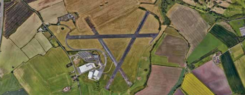
Development Framework
Contents
Site Considerations and Opportunities
Allocation Masterplan Framework
1. Introduction
Introduction
This Supplementary Planning Document (SPD) has been prepared as a collaboration between Rushcliffe Borough Council and the main landowners and developers of the site East of Gamston and North of Tollerton.
Purpose and Role of this SPD
1.1. This SPD concerns the Local Plan allocation known as “Strategic Allocation East of Gamston/ North of Tollerton”. The purpose of this document is to provide further guidance and a development framework for the whole of the strategic site allocation at Gamston, which is the subject of an allocation for mixed-use development including around 2,500 dwellings up to 2028, up to a further 1,500 homes post 2028, around 13.7 additional hectares of employment, neighbourhood centres, blue and green infrastructure, Biodiversity Net Gain and a range of community facilities.
1.2. Given the multiple ownerships on-site, the allocation is likely to be developed through a number of planning applications coming forward at different times. This SPD sets out specific requirements of the local authority, the local highway authority, the local education authority and health providers to ensure those submitting applications are informed about the requirements from the outset. The locations of proposed infrastructure on Figure 41 show the preferred location of infrastructure to create a sustainable new neighbourhood, subject to any refinements required as a result of detailed work and additional evidence that emerges through the development management process.
1.3. The Council will only accept variations to the preferred locations on Figure 40 and Figure 41 where proposals are supported by robust evidence and, in circumstances involving the relocation of infrastructure between landowners, where the Council is satisfied that the infrastructure will be delivered in full and at the appropriate time and in general accordance with the approach and provisions outlined within this SPD.
1.4. The SPD guidance and a development framework in this document, including contributions expected to both on-site and off-site infrastructure requirements, will apply to all areas within the strategic allocation, including any development/re-development of the existing residential areas and their associated land (e.g. equine paddocks) on Tollerton Lane and any redevelopment of existing employment land located to the south of Spire Hospital. Nevertheless, the new (and existing and re-developed) employment uses on the site would be exempt from certain contributions towards Infrastructure such as education provision.
1.5. The site is a long-term commitment for the Council in meeting the growth needs of the Borough and it will continue to be built beyond the local plan period. Once built, it will create a new neighbourhood within Rushcliffe, and it is thus important for the Council and developers of the site to ensure this meets the highest possible standard.
1.6. This SPD fulfils the requirement of Policy 25 of the Local Plan which requires that the design and layout of the proposal be determined through a masterplanning process.
1.7. The document provides guidance for the preparation and determination of planning applications for all parts of the development area and to ensure the co-ordinated achievement of key development targets. It is expected that planning applications for all parts of the development will be in accordance with the framework set out in this document. This will guide decision-making on planning applications as supporting information to policies within the statutory development plan. SPDs build upon and provide more detailed advice or guidance on policies in an adopted local plan. As they do not form part of the development plan, they cannot introduce new planning policies into the development plan. Applications will need to have regard to this SPD, prevailing policies and the latest Government guidance at the time of their preparation and determination. It is envisaged that planning applications that are not in accordance with this SPD are unlikely to be approved.
1.8. This document outlines a development scenario that allows for the separate delivery of different parts of the site, whilst ensuring that the development area is developed in a comprehensive way; and is deliverable in its entirety, including the provision of overall strategic site infrastructure. Nevertheless, it is feasible that other scenarios could come forward of the delivery of the site. This document therefore sets out:
- The expected development capacity;
- The range of facilities needed to support the new population;
- The strategic infrastructure needed to facilitate the new development and how this infrastructure should be secured;
- Development zones and the need for phasing of strategic infrastructure;
- The disposition of land uses and facilities;
- Development areas and the need for phasing of community infrastructure necessary for the successful delivery of the whole scheme;
- General design and development principles to guide the form and nature of development;
- The areas of green and blue infrastructure;
- necessary transport including active travel routes and streets.
1.9. Whilst the SPD sets an overall framework for development, it is acknowledged that a degree of flexibility will be required in the design of detailed proposals, as follows:
- Although street corridors are fixed in scale, the detailed design of streets will need to be explored in greater detail in parallel to the consideration of the access and movement requirements, and optimal development block dimensions.
- Likewise, whilst the location of the green and blue infrastructure is fixed for the wider site, the locations within development phases and the exact design of these spaces (including their boundaries) is subject to detailed design that will be considered in line with adjacent development parcels, streets and active travel routes.
1.10. This document is prepared as a draft for public consultation. It is intended that the document will be finalised following public consultation. Once finalised it is intended that the document is adopted by the Borough Council as an SPD which will be used to provide further guidance to ensure comprehensive delivery of all of the planning objectives for the allocation. The SPD is a material planning consideration for the local planning authority when determining planning applications but is not part of the development plan.
Preparation of this SPD
1.11. This SPD has been developed iteratively, particularly in relation to phasing and infrastructure delivery. It has been developed having regard to the views of site promoters, landowners and developers, service providers and statutory bodies, such as Nottinghamshire County Council’s Education, Ecology, Flooding, and Highways services, the Environment Agency, Historic England, Natural England, as well as Council services including Communities, Ecology, Heritage and Development Management.
1.12 Public consultation was undertaken on a Draft Gamston / Tollerton Masterplan SPD.
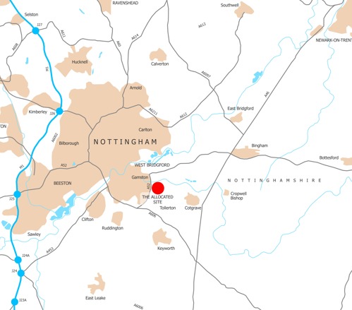
The Allocation and Context
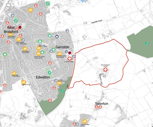
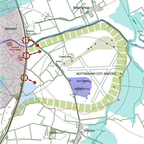
1.13. The area of land covered by the strategic site allocation comprises agricultural fields and most notably Nottingham Airport. The Grantham Canal is located to the north of the site, Polser Brook and Thurlbeck Dyke are to the east, with agricultural fields to the south and the A52(T) is to the west of the Allocation. Tollerton Lane runs through the site roughly in a north-south direction.
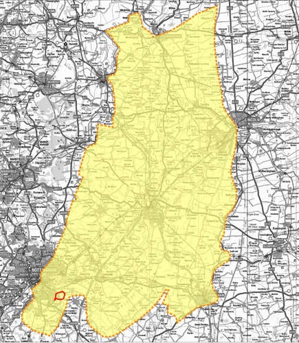
1.14. The overall area of land which is the subject of the allocation is around 247 hectares. The extent of land is shown in Figure 2.
1.15. Tollerton village is located to the south but physically separated from the allocation site. Bassingfield is located to the north of the Grantham Canal, which is also physically separated from the allocation site. Gamston is located to the west of the A52(T).
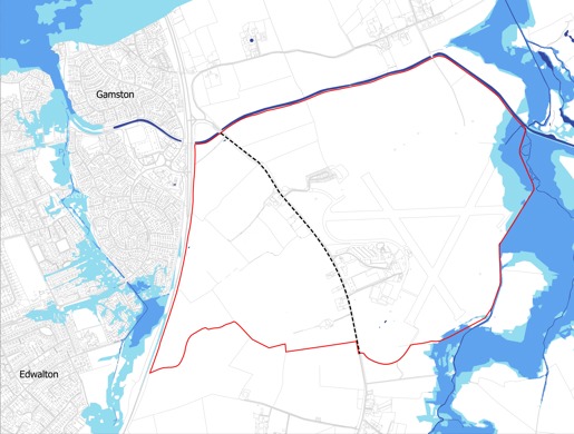
1.16. In defining the Allocation, the Council took the view that Nottingham Airport, the majority of which is a brownfield land resource, should be included in the allocated area. It was considered important that the integrity of Bassingfield and Tollerton as distinct settlements should be protected.
1.17. Based on the work to review the Green Belt when the site was allocated in the Rushcliffe Local Plan, there is justification for the new boundary to be formed using elements of the Grantham Canal, Thurlbeck Dyke and field and other boundaries to the north of Tollerton. This will achieve a suitable degree of separation between the development and the existing settlement.
1.18. The land is owned by different parties and there are developers which control parts of the land. Development is expected to be brought forward through separate planning applications, over a number of years, all set within the framework of Local Plan policy and this SPD.
Planning Policy Background
1.19. The relevant statutory Development Plan for Rushcliffe Borough Council comprises the following documents:
- Rushcliffe Local Plan Part 1: Core Strategy, adopted December 2014
- Rushcliffe Local Plan Part 2: Land and Planning Policies, adopted October 2019
1.20. Nevertheless, it should be noted that the delivery of the site will go beyond the above plan period(s) and therefore this SPD will be relevant to the Emerging Greater Nottinghamshire Strategic Plan (GNSP) (when adopted) and any policy document(s) that might replace or supersede the GNSP.
The Rushcliffe Local Plan Part 1: Core Strategy
1.21. The Rushcliffe Local Plan Part 1: Core Strategy (LPP1), was adopted in December 2014. LPP1 provides the overall spatial vision, objectives and strategy for Rushcliffe Borough to the year 2028. This includes setting out the level and location of new housing and employment land as well as the identification of a number of Strategic Allocations and policies.
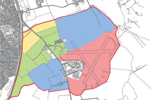
1.22. Policy 25 in the Local Plan Part 1 identifies land east of Gamston and north of Tollerton as a Strategic Allocation. The indicative distribution of the proposed uses within the site allocation boundary is identified on Figure 6 within the Local Plan Part 1, as shown in Figure 4.
1.23. The site boundary for this policy is identified by the red line. Figure 4 shows the indicative distribution of proposed uses, which has been taken into consideration in the preparation of this SPD.
Policy 25 - Strategic Allocation East of Gamston / North of Tollerton
The area, as shown on the adopted Policies Map, is identified as a strategic site for the mixed use development including around 2,500 dwellings up to 2028, up to a further 1,500 homes post 2028, around 20 hectares of employment development, a neighbourhood centre and other community facilities as appropriate. The design and layout of the proposal will be determined through a masterplanning process. The final design, layout and quantum of development shall take full account of heritage assets and their setting. The development shall be appropriately phased to take into account provision of necessary infrastructure, including improvements to the highway along the A52(T) and public transport network. The distribution of the indicative proposed is identified on Figure 6 within the Local Plan Part 1, as shown in Figure 4. The development will be subject to the following requirements:
A. Housing
- A mix of housing types, size and tenure taking into account the existing mix of adjoining and nearby areas of housing, including seeking through negotiation to secure up to 30% affordable housing. The affordable housing should be phased through the development.
- The development should make efficient use of land. New residential should seek to achieve an average net density of at least 30 dwellings to the hectare. Higher densities can be achieved in the central core of development, Primary and Secondary Streets and close proximity to the neighbourhood centres. Densities across the site should consider if it would adversely affect heritage assets and their setting.
- In accordance with policy 9, appropriate provision should be made for Gypsy and Traveller accommodation.
B. Employment
- There should be provision of around 20 hectares of employment land to provide for a wide range of employment opportunities where appropriate. Training opportunities should be provided for as part of the development.
C. Neighbourhood Centre
- A neighbourhood centre of an appropriate scale should be provided to serve the proposed development.
- Community facilities and retail development of an appropriate scale will be provided to serve the new development. On site community facilities should primarily be located within or adjacent to the neighbourhood centre. Where appropriate, enhancements to existing community facilities at Gamston Neighbourhood Centre and within other adjacent villages will be explored as an alternative;
D. Transportation
- Improvements to road infrastructure necessary to mitigate adverse traffic impacts and serve the new development, including improvements to the A52(T) Lings Bar Road.
- Measures as necessary to directly access the Gamston A52(T) Lings Bar Road and to minimise traffic impacts through Tollerton village;
- Improvements to walking, cycling and public transport links through and beyond the site, including where necessary enhancements to existing bus services;
- Implementation of a travel plan;
- A financial contribution to a package of improvements for the A52(T) between the A6006 (QMC) and A46 (Bingham).
E. Heritage Assets
- The production and implementation of a heritage strategy. The heritage strategy will provide a detailed analysis of the significance of heritage assets, including the contribution made by their setting, which will be used to inform the design and layout of the scheme. It will also outline how the proposed development will provide for the protection and/or enhancement of heritage assets and their setting, and include a mitigation strategy;
F. Other Requirements
- Sewage and off-site drainage improvements;
- An appropriate sustainable drainage system;
- A high quality built environment, to create a distinctive character that responds positively to the site, relates well to the surroundings, and gives consideration to the most appropriate sustainable methods of construction;
- The creation and enhancement of open space and green infrastructure which links to the wider green infrastructure network, which has regard to the Greater Nottingham Landscape Character Assessment, and provides for biodiversity enhancements;
- The creation of significant Green Infrastructure areas and buffers, particularly on the southern and northern boundaries to contribute to the creation of permanent defensible Green Belt boundaries between the development and Tollerton and Bassingfield. An enhanced Green corridor should also be created along the Grantham Canal; and
- New or expanded educational, outdoor sports and leisure, health, community, faith, cultural and youth facilities as required by the scale of the development, which is planned in such a way to integrate existing and new communities. Provision or expansion of facilities will be secured through Planning Obligations and/or a Community Infrastructure Levy in line with Policy 19.
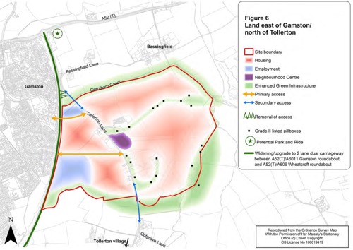
Key
- Site boundary - red line
- Housing - pink areas
- Employment - blue areas
- Neighbourhood Centre - purple
- Enhanced green infrastructure - green areas
- Primary access - yellow arrows
- Secondary access - blue arrows
- Removal of access - zigzag line
- Grade 2 pillboxes - black dots
- Potential park and ride (offsite) - green star
- Widening / upgrade to 2 lane dual carriageway between A52(T) and A6011 Gamston roundabout and A52(T) / A606 Wheatcroft roundabout - thick dark green line
1.24. Policy 25 seeks mixed-use development including around 2,500 dwellings up to 2028, up to a further 1,500 homes post 2028, around 20 hectares of employment development, a neighbourhood centre and other community facilities as appropriate.
1.25. The design and layout of the proposed development is to be determined through a masterplanning process. The requirement for a masterplanning process has resulted in preparation of this SPD.
1.26. Policy 25 refers to Policy 19 “Developer Contributions” within the Local Plan Part 1 and this is covered in the section on infrastructure requirements.
Rushcliffe Local Plan Part 2: Land and Planning Policies
1.27. The Rushcliffe Local Plan Part 2: Land and Planning Policies, was adopted in October 2019. The Local Plan Part 2 sets out the non-strategic development allocations and a number of detailed policies for managing new development, following on from the strategic framework set out in the Local Plan Part 1.
1.28. The Local Plan Part 2 does not change the status of Land East of Gamston and north of Tollerton as a Strategic Allocation.
1.29. A Policies Map, which identifies policies and proposals of the Local Plan Parts 1 and 2, has been prepared by Rushcliffe Borough Council. This shows allocated housing sites and other relevant policy designations.
1.30. Figure 5 is an extract of the Policies Map for the Strategic Allocation and surrounding area.
1.31. The Policies Map identifies the extent of the Strategic Allocation within a hatched area, and it identifies the extent of the Green Belt, which is to the north, east and south of the Strategic Allocation.
1.32. The Policies Map identifies other relevant policies outside of the Strategic Allocation including sustainable tourism and leisure along the route of the Grantham Canal and potential for a link between the Grantham Canal and River Trent, which is safeguarded for this purpose.
1.33. In addition to the Local Plan, there are a number of documents which provide further detail to planning policies at the national level and at the local level. The preparation of this SPD has had regard to relevant policy and guidance.
1.34. Applications for development at the site will need to have regard to this document and any updated policy requirements, legislation or Government guidance at the time of its preparation.
Rushcliffe Authority-Wide Design Code
1.35. Rushcliffe Borough Council has commenced preparation of an authority wide design code, which is intended to replace the Rushcliffe Residential Design Guide (2009). It is envisaged that the authority-wide design code will be adopted. The aim will be to ensure co-ordination and consistency between the authority-wide design code and this SPD for this site.
1.36. This SPD will include specific design codes for the initial development / build out of the SUE. However, whilst the Authority Wide Design Code does not include “codes” for the initial development of the SUE, once the residential elements of the proposal are built and occupied the Authority Wide Design Code will be used to assess future proposal within the SUE on those residential elements in the future.
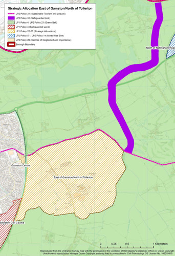
Key
- Local Plan 2 Policy 31 (Sustainable Tourism and Leisure) - pink hatched line
- Local Plan 2 Policy 31 (Safeguarded Link) - thick purple line
- Local Plan 1 Policy 4; Local Plan 2 Policy 21 (Green Belt) - green zone
- Local Plan 1 Policy 4 (Safeguarded Land) - red hatched zone
- Local Plan 1 Policy 20 - 25 (Strategic Allocations) - yellow hatched zone
- Local Plan 2 Policy 5.1; Local Plan 2 Policy 14 (Mixed Use Site) - blue hatched zone
- Local Plan 2 Policy 26 (Centres of Neighbourhood Importance) - cream zones
National Guidance
1.37. This SPD has been prepared with reference to local and national guidance. This section provides a summary of those relating to design.
1.38. The Building for a Healthy Life (BHL) guidance issued on 23 July 2020, is a guidance tool that allows developers, local authorities and local community to evaluate what is important when creating good places to live. It (or any document(s) that supersedes that document) will be used to assess planning applications submitted for consideration.
National Design Guide
1.39. On 1 October 2019, the Ministry of Housing, Communities & Local Government published the National Design Guide. This addresses the question of how we recognise well-designed places, by outlining and illustrating the Government’s priorities for well-designed places in the form of ten characteristics. The National Design Guide is based on national planning policy, practice guidance and objectives for good design as set out in the National Planning Policy Framework (NPPF). It (or any document(s) that supersede that document) will be used to assess planning applications submitted for consideration.
1.40. The NPPF identifies the importance of good design in a range of policies, including that schemes should follow the National Design Guide and National Model Design Code and applicable local design guides. It (or any document(s) that supersede that document) will be used to assess planning applications submitted for consideration.
Secured by Design
1.41. Secured By Design (SBD) is a police initiative that improves the security of buildings and their immediate surroundings to provide safe places to live, work, shop and visit. As a police organisation working alongside the Police Service in the UK, this seeks to achieve sustainable reductions in crime through design and other approaches. SBD has produced a series of helpful Design Guides to assist the building, design and construction industry to incorporate security into developments to comply with the Building Regulations and meet the requirements of SBD. These (or any document(s) that supersede that document) will be used to assess planning applications submitted for consideration.
Building for Beauty
1.42. The Building Beautiful Places plan encourages members of the local community to become involved in decision making associated with the economic development process. It is meant to improve community infrastructure, prioritise high quality neighbourhood design and support walking and cycling to boost physical health and mental wellbeing. This is being taken forward in the National Model Design Code. This (or any document(s) that supersede that document) will be used to assess planning applications submitted for consideration.
Building for a Healthy Life
1.43. Written in partnership with Homes England, NHS England and NHS Improvement, the BHL document integrates the findings of the three-year Healthy New Towns Programme. As a widely known and used design tool, this document provides guidance to creating places that are better for people and nature, they are as follows:
- Developments should be accessible and provide walk-able local facilities including local centre and school;
- Pedestrian and cycle routes to key destinations should be direct and segregated from general traffic;
- Buildings fronting the public realm should display active frontage to maximise natural surveillance;
- Community facilities should be centrally located and within short walking distance to the majority of residents;
- Development should offer a network of multifunctional open spaces;
- Pedestrian and cycle routes should archive high quality standards, be well-lit and well surveilled;
- Local Equipped Area for Play (LEAPs) should be generally located within 5 minutes walking distance from dwellings;
- Pedestrian and cycle routes to key destinations should be direct and segregated from general traffic;
- Finally, development should provide an extensive network of open spaces. This includes community parks for physical and mental health benefits, as well as formal and informal pedestrian/cycle networks.
1.44. This (or any document(s) that supersede that document) will be used to assess planning applications submitted for consideration.
2. Vision
The development on Land East of Gamston and North of Tollerton is one of a number of allocated sites in the Local Plan that will assist the Council in meeting the current and future housing needs of the area.
2.1. Development of the site provides an opportunity to comprehensively plan for mixed-use strategic-scale development. The vision and framework for development must address the needs for new homes, employment, and social and environmental infrastructure whilst responding to the special character of this part of Greater Nottingham. The new development should comprise sustainable development that will provide environmental, social and economic benefits. Place-making is at the centre of the vision for the development. This is a development that is envisaged to be delivered over the next 15 to 20 years.
2.2. The Vision for the development is not to recreate, or generate pastiche, but to analyse what is already in the local area, in terms of traditional design clues, and provide a starting point for high quality design. This includes the type of streets, type of spaces, and typical materials.
2.3. The objective is to move away from bland vehicular led ‘non-descript housing estates’ and to deliver an attractive enduring place, which is related to its built and natural context whilst ensuring compliance with highway design guides and standards.
2.4. A well-considered place is not just about homes and buildings, but also the quality of the streets, places and movement routes. This includes how buildings interact with the streets and the quality of the landscape, green spaces and the public realm. All of these elements will be covered in the Design Codes.
2.5. This SPD provides planning guidance to help deliver a quality place where people want to live and work, designed according to sustainability principles.
2.6. Given the scale of the development, there is a need to ensure a coherent and co-ordinated approach to create a new neighbourhood which is delivered on a phased basis alongside the necessary supporting infrastructure to ensure that the overall policy aspirations are met.
2.7 In summary the objectives for the development are as follows:
To create a new neighbourhood, comprising a mix of uses that incorporate current best practice in sustainable and urban design (in line with NPPF policy on achieving well-designed places). The district centres and other movement generating uses shall be designed so that they prioritise pedestrian and cycle movements, (incorporating pedestrian permeability and cycle friendly streets and routes), maximise public transport access and integrate open space and biodiversity within the built form and green infrastructure network. The development shall ensure that this is a new neighbourhood that maintains its own sense of identity by safeguarding a significant buffer of land that retains the physical and visual separation between the allocated site and the village of Tollerton. This landscaped buffer will, as part of the site wide green/blue infrastructure network, create a new green infrastructure corridor that:
- Retains and strengthens the existing hedgerow and tree planting where possible, taking into account the preferred location of the primary road network and access to development parcels;
- Introduces new hedgerow and tree planting;
- Creates new habitats;
- Creates recreational routes for walking, cycling and running, and informal/ semi-natural open spaces and play areas; and
- Incorporates small-scale drainage/SuDs where appropriate unless there is a demonstrable benefit in combining drainage/SuDs to serve multiple development parcels and this results in acceptable landscape, drainage and design.
Green/blue infrastructure - The site contains areas of habitat, including hedgerows and the Grantham Canal, that have ecological, cultural and amenity value. This SPD requires that new development within the site protects, enhances and secures the future of these important habitats and the species that inhabit them. This SPD also requires protecting and enhancing corridors to enable current and future species to move in, out and through the development area (in line with NPPF requirements on conserving and enhancing the natural environment). This SPD also requires that a measurable Biodiversity Net Gain is secured that promotes onsite conservation and mitigation within the development area boundaries (with compensation only being provided elsewhere within the Borough as a last resort);
Transport Infrastructure - The site is largely open countryside containing an operational airfield, a mobile home park, existing employment units, a hospital and a number of private residential properties. In order to deliver the Local Plan allocation for employment and housing at Gamston/Tollerton, highways, walking, cycling and public transport infrastructure needs to be put in place, to enable the developments to function effectively (in line NPPF requirements on promoting sustainable transport). Establishing the primary road network through the site (and the downgrading of Tollerton Lane), connecting to the existing road network and alleviating the traffic impact of the development on the existing highway network and surrounding area, will be key; and
Community Infrastructure - The Gamston/Tollerton allocation will be effectively creating a new community that will require health services, education, shops, and local play space facilities. These will be needed to create a sustainable development and to achieve the key aim of the NPPF (and more specifically NPPF policy promoting healthy and safe communities). This also relates to habitat and ecological enhancement as the provision of green infrastructure will also contribute to healthy active lifestyles.
Gamston/Tollerton Masterplan
2.8. As required by Policy 25 this SPD has been produced to guide comprehensive delivery of the site and provide a framework for the masterplanning process, by setting out the Council’s preferred locations for open space, access, play areas, the schools, primary roads and other features. This SPD also identifies the location of the existing on-site Heritage assets (Listed Pillboxes) and their relevance and relationships to the current runways they sought to protect within the allocated site – further detail in relation to the pillboxes is set out in the Archaeology section in Chapter 3 of this SPD.
2.9. Apart from in relation to access arrangements to the site from the A52, which have not yet been determined and are still the subject of discussion with the highways authorities, the Council will only accept variations to the preferred locations of infrastructure as shown on the masterplan at Figure 41 where proposals are:
- Supported by robust evidence, and
- An alternative Masterplan identifying any variation is agreed between the Council, County Council and all of the respective landowners to which the variation relates, and
- In circumstances involving the relocation of infrastructure between landowners, the Council, the County Council are satisfied that the infrastructure will be delivered in full and at the appropriate time and in general accordance with the approach and provisions outlined within this SPD.
Phasing and delivery
2.10. The site is a long-term development allocation which is expected to be delivered over a 15-20-year period and will continue to be developed beyond the time period covered by the Local Plan. Policy 25 requires development proposals within the allocation be determined through a masterplanning process. The Council will not support ad hoc or piecemeal development that is inconsistent with the masterplan for the allocation as set out in this SPD except in the circumstances set out in paragraph 1.9 above.
2.11. The phasing of the allocation is extremely important to the successful and timely delivery of the site and the supporting infrastructure to support a new neighbourhood throughout the construction phase and until it is built out in its entirety.
2.12. The provision of necessary infrastructure to deliver the Gamston/Tollerton allocation is outlined in the Strategic Infrastructure Plan, which can be found appended to this SPD.
Delivery Strategy
2.13. In order to deliver mixed-use development across the whole of the strategic allocation, Nottingham Airport will close and cease operations and some of its existing commercial operations will potentially relocate elsewhere. It is also acknowledged that some of the existing employment uses located alongside the airport might also need, or choose, to relocate resulting in the potential for the re-development of, or changes of use to, the existing businesses/uses/operations occurring in this area, annotated as “existing employment” on Fig. 40. However, it is still expected that this area of land will continue to deliver employment uses as part of the wider allocation, albeit with potentially different users/operations occurring (to be assessed through the planning process as necessary). No new dwellings on the allocation will be permitted to be occupied whilst the airport is still operating.
Strategic Infrastructure and Phasing
2.14. The Gamston Sustainable Urban Extension Infrastructure Delivery Plan (Gamston SUE IDP) will set out the strategic infrastructure and other mitigation measures and the anticipated indicative cost of each item. This is based on the currently available information. Costs may be further updated and refined as the detail of infrastructure proposals is confirmed.
2.15. The delivery of infrastructure and phasing of the allocation will be governed by the principle that infrastructure should be provided in line with the appropriate phases/triggers set out in the Gamston SUE IDP in order to mitigate the impacts of development.
Securing Infrastructure Requirements
2.16. A Section 106 legal agreement will be required to be entered into in respect of each significant planning application for development within the allocation site. Each Section 106 agreement will include triggers to ensure strategic infrastructure contributions are made at appropriate times. Each Section 106 agreement will be drafted in line with a framework Gamston SUE Section 106 Agreement which will set out the provisions which the Council will expect to be included in each Section 106 Agreement. This is explained in detail in Chapter 5 of this SPD.

A new residential neighbourhood on the eastern side of Nottingham within the Borough of Rushcliffe. A Sustainable Urban Extension, which will deliver around 4,000 new homes, set within a green and blue infrastructure that will deliver significant Health and Wellbeing, Amenity and Biodiversity benefits.

Distinctive character areas are identified to reflect different parts of the site and its context. These areas draw inspiration from the landscape, historic urban form and characteristics of surrounding villages thereby creating a sense of place whilst keeping with the local vernacular and distinctiveness.
Meeting the housing needs of the District
- Around 4, 000 homes within an area identified for growth;
- A mix of housing types for families, young people and ageing population;
- Provision of affordable rent and ownership tenures that are much needed in the local area.

At the ‘Heart’ of the new neighbourhood the majority of the key Community, Education, Recreation and Retail facilities will be provided centrally within a ten-minute walking distance of most homes to minimise the need for journeys by car. Encourage active travel options for parents and children.

Proactive approach to tackle change:
- Incorporate and champion innovation and sustainable technologies within all new build development on the site;
- Walkable neighbourhoods and local work opportunities to limit reliance on car use;
- Sustainable construction methods and materials.
Assisting a new wave of economic growth:
- Opportunities to live and work within an attractive environment;
- Adaptive to changing work practices;
- Respond to demands for home working and shared office space.

Employment provision will also help to deliver a balanced development profile. The implementation and use of new technologies will be considered as a positive and forward-looking part of home and lifestyle delivery.

Health and Wellbeing will be encouraged and promoted through the provision of dedicated cycle tracks and circular routes and trails which will aid pedestrian connectivity both within and beyond the site boundary. Site wide strategies for Heritage interpretation and Play will inform and be informed by this overarching ‘green’ framework.
A site wide comprehensive green infrastructure framework will ensure the creation of a cohesive network of green spaces and landscape features throughout the entire site. Detailed plans for these elements will be provided in future site applications.
3. The Site and Context
Site Context
- Landscape and Visual Context
- Local Built Character
Site Features
- Topography
- Hydrology
- Highways Network
- Public Transport
- Facilities
- Heritage
- Archaeology
- Ecology
- Noise and Air
Site Considerations and Opportunities
Site Context
Landscape and Visual Context
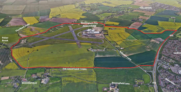
3.1. The strategic allocation site Land East of Gamston and North of Tollerton is the largest strategic site in the Local Plan for Rushcliffe Borough. This location was chosen as a strategic site in line with the spatial strategy contained within the Local Plan Part 1 (adopted December 2014), which focuses development in and around the Nottingham conurbation where it falls within or adjoins Rushcliffe Borough. The allocation is also proposed to be retained in the emerging Greater Nottinghamshire Strategic Plan which is due for adoption in 2026.
3.2. The site includes land either side of Tollerton Lane, to the east of the A52(T) and north of Tollerton village and includes Nottingham Airport.
3.3. The area of land covered by the allocation for development includes existing residential and commercial properties such as Tollerton Park, Spire Hospital and some residences and commercial properties. There is also an underground pipeline running on a broadly north-south axis through the western part of the site.
3.4. The following pages describe the allocation in its wider context, which includes technical and environmental consideration.
3.5. One hundred and fifty nine (159) National Character Area (NCA) profiles have been prepared by Natural England for distinct natural features and characteristics of the landscape across England. Each NCA profile includes a description of the natural and cultural features that shape the landscape, how the landscape has changed over time, the current key drivers for ongoing change, and a broad analysis of each area’s characteristics.
3.6. Figure 7 shows the location of the site within the NCA 48: Trent and Belvoir Vales.
3.7. National Character Area ‘48: Trent and Belvoir Vales’ describes a very broad geographic area of undulating farmland, which is centred upon the River Trent. The profile document for ‘Trent and Belvoir Vales’ describes the key characteristics of this area.
3.8. At a regional level, the East Midlands Landscape Character Assessment (2010), places the site within Landscape Character Type (LCT) ‘4a: Unwooded Vales’ and identifies the key characteristics of this landscape.
At a district level, the Greater Nottingham Landscape Character Assessment (2009), identifies the site as Regional Character Area (RCA) ‘South Nottinghamshire Farmlands’. The RCA is further subdivided into six Draft Policy Zones (DPZ) where the majority of the site is located within DPZ ‘SN04 Cotgrave and Tollerton village Farmlands’, with minor portions of the site along the A52(T) Gamston Lings Bar within ‘TW01 Gamston and Edwalton Meadowlands’ and ‘TW03 Holme Pierrepont and Bassingfield Village Farmlands’. The key characteristics of these landscapes are identified in this assessment.
3.9. Policy 25 of the Local Plan requires that development proposals include significant Green Infrastructure areas and buffers, particularly on the southern and northern boundaries, to contribute to the creation of permanent defensible Green Belt boundaries between the development and Tollerton and Bassingfield. Policy 25 also requires an enhanced Green corridor to be created along the Grantham Canal. The buffers must form part of a green infrastructure corridor which runs around the perimeter of the proposed residential area of the allocation, and forms part of the allocation-wide green-infrastructure network. Development in, and adjacent to, these areas will be required to comply with the policy requirements and include a significant landscape buffer between the site and Tollerton and Bassingfield.
3.10. Along the whole of the landscaped buffers it is considered that strengthening the existing hedgerows and any tree planting and the introduction of new planting of a similar type to the existing (in terms of height, depth and species mix) will maintain and strengthen the existing visual and physical character of the gap between the site and both Tollerton and Bassingfield and ensure a gap is maintained in the future between the two settlements and the site. In addition, this planting along with the creation of new habitats for biodiversity, new recreational routes and informal/semi-natural open spaces will contribute to the green infrastructure network. These open space typologies will form part of the allocation’s open space provision.
3.11. This will provide opportunities to safeguard and enhance the Listed Buildings (Pillboxes), and any trees subject to Tree Preservation Orders that are adjoining or close to the allocation. It will also provide opportunities to create improved access to the green infrastructure network as well as the wider countryside by expanding and improving the walking and cycling environment for leisure and active travel, benefiting health and well-being and improving accessibility for both existing and new residents of the allocation, as well as enhancing biodiversity.
3.12. Uses of land within the buffers must be informal with the objective of maintaining the existing character. Suitable uses would be uses such as the planting as described above; habitat creation; informal recreational uses such as recreational walking, cycling and running routes; seating areas; and informal/ semi-natural open spaces. Formal playing pitches, changing rooms and buildings are considered inconsistent with the existing open character and functional relationship between the two settlements and so would not be appropriate land uses within the buffer(s).
3.13. Raised land or man-made features such as bunds would also not reflect the existing flat and open topography of the land between the two neighbouring settlements and are not a characteristic of this landscape. Such features will only be considered by the Council if they are required to mitigate the impact of the development on the existing residents of Bassingfield and Tollerton respectively.
Local Built Character
3.14. This analysis is to be used in all future planning applications, (including reserved matters applications, Section 73 applications etc).
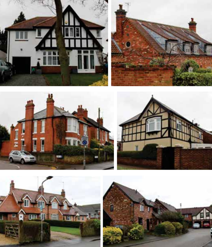
Applications should demonstrate how they conform with this analysis and set out clearly how the characteristics have influenced the proposal(s). Greater levels of analysis will be required within subsequent Design Codes that will also be required as part of all future planning submissions as set out in the Site Wide Design Code (Appendix A of this SPD). The nature and form of the proposal should be informed by a contextual analysis of the local built form to ensure that it will positively contribute towards the delivery of an integrated and responsive development. The studied areas, identified in photos on the right, were selected because of their distinctiveness and architectural character, with a particular focus on the positive features which make these attractive places.
3.15. The site lies on the edge of Nottingham and near several historic settlements, some of which date back to the 16th century, and have also been subsequently extended with additional development. As such, it is appropriate for this character assessment to understand the qualities of the historic built form, and subsequent developments, to draw inspirations from or, in some cases, to learn from mistakes made. To positively respond to the local character of the area, an analysis of the settlements located within close proximity to the site is required (as part of all future planning applications) and must range from rural to more urban characters, including both historic and contemporary developments.
3.16. The analysis should identify key characteristics such as (but not necessarily limited to) the following:
- Streetscape
- Built Form & Scale
- Architectural style & Material
- Boundary Treatment
- Roofscape
3.17 The following pages set out examples of how the analysis of study areas surrounding the site should be structured for semi-rural, suburban characters and primary routes. They are intended as a guide, not a definitive template, but the key principles set out should be adhered to.
Streetscape
Semi Rural Character

- Incidental open spaces can help to soften the streetscape by allowing pockets of vegetation.
- Strong sense of enclosure created by continuous building frontages around open space. ˙
- Retain mature trees within publicly accessible open space.
- Create a traffic calmed environment that is cycle/ pedestrian friendly.
Suburban Character
- Continuous building frontage, generally parallel to the street with consistent distances between buildings and regular setbacks.
- Street verges along higher order roads allow space for street tree planting.
- Generous front gardens allow space for planting to soften streetscape.
Primary Street
- Continuous frontage with regular gaps between buildings and consistent building line/setbacks.
- Building to emphase verticality in order to respond to the road wide corridor.
- Streets with generous pavements.
- Tree lined Avenue.
Built Form and Scale
Semi Rural Character
- Variation in building orientation with properties fronting onto open space providing active frontage to the development edge.
- Buildings are predominantly 2 to 2.5 storeys.
- Predominantly large detached dwellings served by private drives in some cases.
- Courtyard arrangements incorporating parking.
Suburban Character
- Predominantly formal character with north/south facing back-to-back properties.
- Mostly terraced and semi-detached with occasional detached units.
- Building heights vary from 2 storeys to 2.5 storeys.
- Dwellings aligned to the street with on-plot parking.
Primary Street
- Predominantly back-to-back block typology with consistent building line.
- Building heights at 2 and 2.5 storeys, with 3 storey in key locations.
- Dwellings are accessed via Mews Street from the back, with side streets or access lanes located to the front of the dwellings.
Architectural Style and Material
Semi Rural Character
- Arts and Crafts inspired architecture.
- Wall materials to include orange/red brick and occasionally variety of light render.
- Simple gable and hipped roof forms.
- Dormer windows.
- Integral garage.
Suburban Character
- Both traditional and contemporary architectural styles with reference to local building materials.
- Minimum variation in roof profile.
- Wall materials to be predominantly red brick.
- Grey slate (or equivalent) roof tile.
- Block paved private drives.
Primary Street
- Both traditional and contemporary architectural styles are appropriate.
- Consistent roof profile.
- Grey slate (or equivalent) roof tile.
- Richly detailed elevations with variation in material.
Boundary Treatment
Semi Rural Character 
In low density areas dwellings sit within a landscape setting. Boundaries are defined by.
- Hedges.
- Split rail fencing.
- Low brick walls, which match the building material.
Suburban Character
- Buildings are set behind front gardens containing low shrub planting.
- Boundaries are defined by low brick walls or metal railing sometimes in combination with hedges.
Primary Street
- Within the local centre, buildings will be set close to the footpaths or carriageway.
- Planting to be introduced to soften the streetscape.
- Boundary treatments are a mix of low brick walls and railings.
Site Features
3.18. The following pages assess the Site itself and its unique features, providing a technical baseline to inform future proposals. The response to those features is intended help to determine how well integrated into their context the proposals are.
Topography
3.19. The land is gently undulating, with ground levels at a high point of approximately 40m Above Ordnance Datum (AOD) around Tollerton Road, falling gradually to approximately 25m AOD in the east. The topography is highest in the central part of the site, falling outwards to the site extents (as shown on Fig.10).
3.20. The airport area slopes towards the south-east and has open views out towards the surrounding countryside. The area to the south of the airport slopes down gently in a broadly southern direction with clear views of the airport buildings from the public footpath to the south. The land north of the airport boundary slopes down towards Grantham Canal. The land to the west of Tollerton Lane has a more gradual slope northwards, towards the canal, and westwards up to Lings Bar Road (A52(T)), whilst to the south the land rises towards Homestead Farm (the farm on Little Lane), Tollerton.
Ground Conditions
3.21. The site comprises previously developed land and undeveloped land, some of which is in agricultural use. The local bedrock is identified on the British Geological Survey web viewer as Mudstone (Fullers Earth formation) with no superficial deposits.
Pipeline
3.22. There is an underground pipeline running on a broadly north-south axis through the site, predominantly to the west of Tollerton Lane which has a 3m easement either side, all development must be located outside of the easement.
Contamination
3.23. Due to the current and historic uses of the site there is the potential for land contamination to be present across the whole site. Any potential risks to human health and / or the environment must be robustly assessed part of the planning application process, with any suitable mitigation proposed where necessary. The landowners must obtain any necessary licences or permits (outside of the planning process) before any excavations, or pre surveys, that would disturb or break the surface of the land are undertaken.
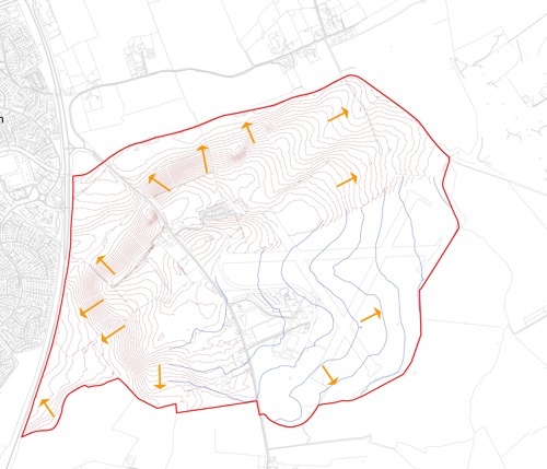
Key
- Allocation Boundary - red line
- Direction of slope - orange arrow
- Contours 0.5m - light red lines
- Contours 2m - blue lines
Hydrology
3.24. The River Trent flows in a north-easterly direction 2km north of the site. The Grantham Canal flows along (but outside of) the site’s northern boundary. There are several small drains mapped within the site’s boundary to the west and a small ‘ordinary’ watercourse, the Polser Brook, flows along the site’s eastern boundary in a northerly direction.
3.25. The source of the Polser Brook is just upstream of Normanton-on-the Wolds, to the south of (and outside of) the site. Further to the east (and outside) of the site’s boundary there are several land drains, including the Thurlbeck Dyke. There are also a small number of additional drains to the north of the Site which are culverted under the Grantham Canal.
3.26. The site’s topography generally falls away to the west and north-east, forming a ridge line at Tollerton Lane, effectively creating two separate catchments within the site as illustrated in Figure 11.
3.27. The eastern catchment currently drains to the Polser Brook, conveying run-off from the upstream catchment and the site and flowing through a culvert under the Grantham Canal to the sites north. The confluence of the Polser Brook and River Trent is some 2km downstream. This drainage catchment is hydraulically connected to the wider land drainage network, conveying run-off from the land.
3.28. According to the Flood Map for Planning , most of the site is located within Flood Zone 1 (Figure 10), suggesting that the risk of flooding from fluvial and tidal sources is low. Areas located in flood zone 1 have less than 0.1% chance of flooding in any given year.
3.29. A small area in the north-eastern part of the site lies within Flood Zone 3. Areas within Flood Zone 3 have a predicted flood risk probability of greater than 1 year.
Key
- Flood zone 1 - white,
- Flood zone 2 - light blue,
- Flood zone 3 - darker blue,
- Grantham Canal and Thurbeck Dyke are shown in navy blue,
- The allocation boundary is shown as a red line.
Highways Network
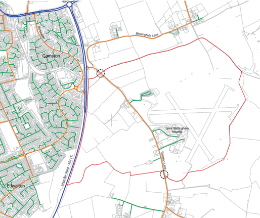
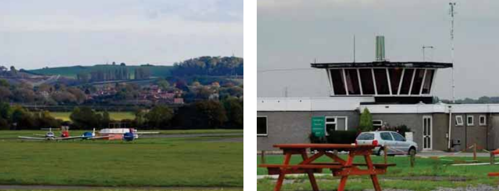
3.30. The site lies adjacent to the A52 (T) (Gamston Lings Bar Road) and is bisected by Tollerton Lane, which provides access to several dwellings, the Spire Nottingham Hospital and Nottingham City Airport/Airfield and several existing businesses (Figure 12). The Gamston Lings Bar Road in this location is currently a single lane carriageway towards the southern extent of the site and a dual carriageway to the north, subject to a varying speed limit along its length. Tollerton Lane is a single lane two-way carriageway, approximately 6 metres wide. It runs broadly in a north-south alignment and continues southwards through Tollerton village, where it is subject to speed limits dropping from 50mph, to 40mph through the site (as you leave the A52 (T)) and a 30mph speed restriction at the entrance to, and through Tollerton Village. It forms a three-arm signalised junction with the A606.
3.31. The A52(T) Radcliffe Road is located to the north of the site and runs broadly in an east-westerly alignment. The Radcliffe Road provides a connection west towards Nottingham City Centre, and east out towards the A46 and beyond to the A1. The A52(T) Radcliffe Road, in the vicinity of the junction with the A52(T) Gamston Lings Bar Road, is subject to a 40pmhl speed restriction. Ambleside (a primary residential street in the Gamston development to the immediate west of Lings Bar Road) forms a priority junction with the A52(T) Gamston Lings Bar Road, incorporating an on and off filter to the major carriageway, and with a gap in the central reservation for right turners. Ambleside is subject to a 30mph speed limit and provides access to Gamston Local Centre via a roundabout as well as the surrounding residential area.
3.32. Bassingfield Lane (located to the north-western corner of the allocation) forms a priority junction with Tollerton Lane, approximately 80m east of the junction with the A52(T) Gamston Lings Bar Road. Bassingfield Lane is a country lane, subject to the national speed limit and delivers access to a handful of properties before connecting to the A52(T) Radcliffe Road to the north-east.
Key
- Allocation boundary - red line
- Primary road - blue line
- Minor road - orange line
- Local road - green line
- Existing vehicular access point - dashed circle
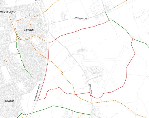
Walking and Cycling
3.33. There are several shared footway / cycle track routes, and roads recommended for cycling, in the vicinity of the site. The network provides access to local shops, schools, services and employment in West Bridgford. It also links to planned cycling improvements being delivered by Nottingham City Council in the form of a new bridge over the River Trent, providing cycling connectivity to the City Centre. Public footpath T FP6 crosses the south of the site on its route from Gamston to Tollerton Lane. More widely there are several public rights of way and established routes, including:
- The towpath along Grantham Canal adjacent to the northern boundary of the Site;
- Public footpath G FP7 crosses the land between A52(T) Gamston Lings Bar Road and A52(T) Radcliffe Road north of the site;
- Public footpaths HP FP4, HP FP16, ROT FP1 connects Bassingfield village to Stragglethorpe Road to the northeast of the site;
- Public footpaths T FP1, CL FP6 and CL FP1 all lie south of the site, connecting Tollerton Lane and the northern edge of Cotgrave to Clipston village; and
- Public bridleway T BW5 and footpath T FP4 lead from A52(T) Gamston Lings Bar Road to Tollerton Lane past Homestead Farm south of the site.
3.34. National Cycle Network (NCN) Route 15 can be accessed via Ambleside and Regatta Way (both recommended roads for cycling) to the west and north west of the site. NCN Route 15 connects to Route 6 in Belton and Route 1 near Coningsby. A plan of the public rights of way and routes is shown in Figure 13.
Key
- Allocation boundary - red line
- Public Right of Way - orange dashed line
- Bridleway - green line
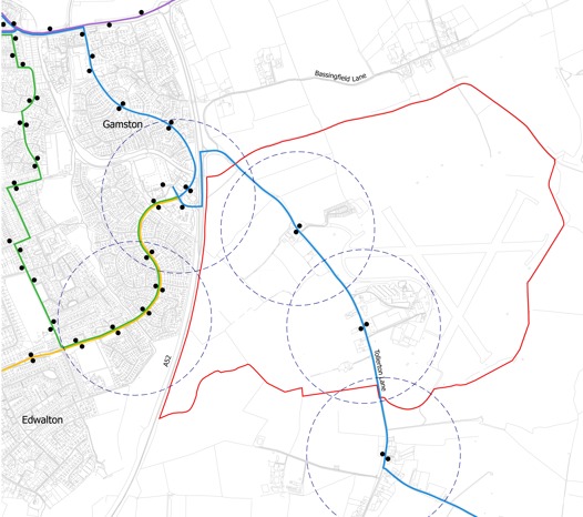
Public Transport
3.35. There are several existing bus services which operate close to the proposed site, including services on Tollerton Lane (within the Site).
3.36. Bus stops are located to the north of Tollerton Lane, adjacent to the existing Tollerton Park homes, and benefit from a shelter and printed timetable information on the northbound side of the carriageway. Additional stops are located adjacent to the Spire Nottingham Hospital, and the southern parcel of land, which have been upgraded to provide a shelter and printed timetable information. The pedestrian and cycle accessibility has also been improved with a 3m wide shared footway, albeit only for a short length adjacent to the hospital. There is therefore a requirement to extend this pedestrian and cycle route, along Tollerton Lane, through the site and beyond to connect into neighbouring networks.
3.37. Additional bus services can be accessed on the western side of the A52 (T), adjacent to the Morrisons supermarket car park.
3.38. A plan of the bus routes within the surrounding area are shown opposite in Figure 14 but improvements to the existing facilities, and the provision of new facilities through the development will be required to accommodate the level of population growth and the drive to use public and sustainable modes of travel.
Key
- Allocation boundary - red line
- The Cotgrave - purple line
- Bus route 5 - yellow line
- Bus 7 - green line
- Bus route 822 - blue line
- Bus tops shown with black dots, and
- 400 metre bus stop distance by hatched line circles
Facilities
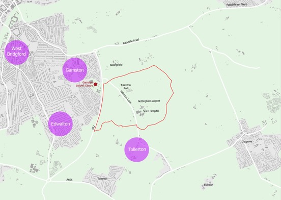
3.39. Gamston has a range of services and facilities, the majority of which are located to the west (but outside) of the site, on the other side of the A52(T) (Figure 15). These include Morrisons’ supermarket, shops, pubs, cafes, takeaways, surgeries, pharmacies, dentists, and other facilities. Gamston also has a diverse range of social and community activities, including numerous sports and recreational facilities and clubs.
3.40. In terms of education, there are primary schools in the south-eastern suburbs of Nottingham and within the centre of Cotgrave. The nearest secondary school is Rushcliffe School, approximately 2.5km west of the centre of the site. Recreation facilities include Rushcliffe Arena, several gyms, outdoor sports grounds as well as leisure centres in Nottingham, two golf clubs immediately north-east and south-west of the site plus Holme Pierrepont and Cotgrave County Parks.
3.41. There is an extensive range of services and facilities within or close to Nottingham city centre, including secondary retail, offices, leisure, education (including two universities) and other cultural uses. There are also employment areas, including business parks and industrial estates, located alongside the River Trent that dissects the city. Figure 15 provides a summary of some of the key services and facilities in the immediate area.
3.42. West Bridgford (which has an extensive range of services and facilities) is located approximately 4.5 km northwest of the Site and can be accessed via bus services as well as via the public rights of way networks.
Key
- Allocation boundary - red line
- Existing development - grey zones
- Local or district centre - red dot
- Place of worship - church symbol
- Education - children walking symbol
- Hospital - white cross on a red circular background
- Allotments - apple symbol
- Outdoor sports - ball sports symbol
- Golf Course - golf flag symbol
- Public house - beer glass symbol
- Supermarket - shopping trolley symbol
- Employment - briefcase symbol
Heritage
3.43. To address the built heritage sensitivities of the site, all planning applications for the development of the site must be accompanied by full Built Heritage Statement(s), identifying all heritage features (including but not limited to listed buildings, conservation areas, non-designated heritage assets, Scheduled Ancient Monuments (SAMS) along with any potential for buried archaeology. The Heritage Assessment(s) will also provide a detailed assessment of the significance of the heritage asset(s), including the contribution made by their setting, along with a clear detailed assessment of how this understanding has been used to inform the design of any planning proposal and the mitigation and on-going maintenance and management responsibilities for the heritage asset(s) within the site of the individual planning applications.
3.44. A full understanding of the broad landform context of the site is paramount to inform the heritage assessment. The development proposals must also adhere to Rushcliffe Local Plan Policy 10 and respond to the ‘setting of heritage assets’.
3.45. The assessment will also outline how the development will provide for the protection and/or enhancement of heritage assets. It will include a mitigation strategy demonstrating how impacts have been addressed, as well as highlighting any heritage and public benefits that could be delivered by the scheme.
3.46. The site itself is characterised by the undulating nature of the broad valley slopes of the River Trent. The more immediate context of the site is gently undulating with localised areas of higher ground forming visually prominent ridges to the south-east around Cotgrave and Clipston at approximately 95 metres AOD, Sharp Hill to the west at approximately 80m AOD and Radcliffe on Trent to the north-east at approximately 75m AOD.
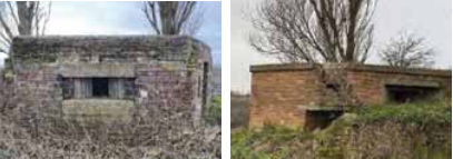
3.47. There are seventeen Grade II Listed pillboxes located within the allocated site. Policy 25 of the Local Plan Part 1 acknowledges that the development of the Tollerton airfield will likely have some potential harm to the pillboxes either directly and/or through changes within their settings is unavoidable (but must be mitigated as part of the planning proposal).
3.48. The development of the allocated site however does have the potential to enhance opportunities for public engagement and understanding of the pillboxes and the wider military history of RAF Tollerton. The significance and place- making value of the pillboxes and runways must also be utilised to create a distinct identity for the scheme, that integrates and celebrates the wider sites military heritage. This will also allow for the future life of the development to be underpinned and shaped by its community’s understanding, recognition and celebration of its heritage.
3.49. Based on a full understanding of the individual and collective significance of the pillboxes, the delivery of the allocation will therefore be designed to minimise harmful impacts on the pillboxes as well as strengthen the understanding of their history to deliver both extensive heritage and public benefits.
3.50. The framework below establishes the main principles that will guide the approach to the site masterplanning to ensure the heritage significance of the pillboxes and runways are protected and addressed whilst securing the opportunities to both enhance public engagement and to create a strong sense of place.
Heritage Strategy - Outline Stage
- The requirement to retain, maintain and preserve the seventeen pillboxes, and the location and alignment of the runways within the development.
- A publicly accessible route connecting the retained pillboxes will form the basis of a heritage trail allowing for different aspects of the pillboxes heritage to be understood. This route will work with the sites natural typography and must ensure that it will be accessible for all to enjoy.
- The relationship between the pillboxes as well as with the wider airfield space should be sustained in the design approach to the development.
Reserved Matters Stage
- A full condition survey of each pillbox, and any other heritage asset identified will be undertaken in consultation with the Local Planning Authority and other relevant heritage consultees to inform the extent of repairs required and identify viable re-use options.
- A strategy for the maintenance and upkeep of the pillboxes will form part of a wider management plan for the development to be secured via S106 agreement.
- The implementation of a coherent heritage interpretation scheme which complements the overall masterplanning approach in respect of the pillboxes, the alignment of the runways and any other heritage assets identified; this must enhance the understanding of the historic operation of the pillboxes and other heritage assets and their relationship (s) to the wider airfield for future residents and visitors to the site to understand.
Archaeology
3.51. The masterplanning of the site will be informed by an archaeological assessment. Where areas of archaeological importance are identified through archaeological investigations, the masterplanning of the development must respond to ensure these are addressed in accordance with the relevant policies and guidance. Each planning application for the Site must include an archaeology assessment and demonstrate how the proposals have been informed by that assessment. Where required, adjustments may be required to the proposed use and/ or treatment of those areas of the site. A coherent heritage interpretation on site and provide an understanding of the heritage assets and their relationship to the Site and locality must be provided on site. This will be achieved by:
- providing walking and cycling routes nearby to assets;
- provide information boards;
- explore themed play spaces;
- references within future street names (subject to compliance with separate legislation).
Key
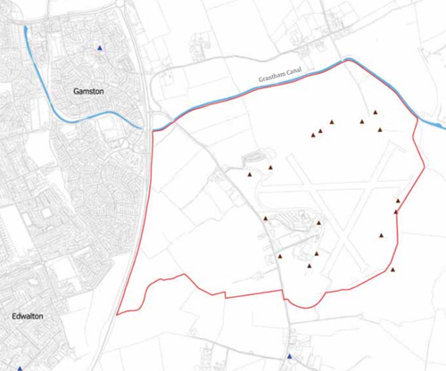
- Allocation boundary - red line
- Non-designated heritage asset (Grantham Canal) - blue line
- Listed building - pillbox - black triangle
- Listed building - bllue triangle
Ecology
3.52. The site comprises a mix of arable land, small areas of dense and scattered scrub, ephemeral and ruderal vegetation. It also includes hedgerows with scattered trees forming field and site boundaries, wet and dry ditches also at field boundaries and poor semi-improved grassland, predominantly associated with Nottingham City Airport as illustrated in Figure 17.
3.53. There are no national or international level statutory designations within or within proximity of the site. One statutory designated Local Nature Reserve is located to the south-west beyond the A52(T) i.e. outside of the site. Three non statutory designations at a local level exist within 1km of (but again outside) the site. Designated sites within proximity (but outside) of the site include:
- Meadow Covert Local Nature Reserve;
- Grantham Canal (Cotgrave to River Trent) Local Wildlife Site; Grantham Canal, Cotgrave Local Wildlife Site;
- Gamston Pits Local Wildlife Site;
- Shady Lane Pits Local Wildlife Site.
Key
- Allocation boundary - red line
- Trees - green dots
- Hedges - green lines
- Other woodland - green
- Local nature reserves - yellow
- Priority nature areas - purple
Noise and Air
3.54. The main sources of noise in the location of the site are road traffic noise and aircraft (both fixed wing planes and helicopters) noise associated with Nottingham Airport and the neighbouring businesses. The airport is within the area of land allocated for development and therefore operations on the airfield itself will cease. This is subject to confirmation and will be required prior to first occupation of any homes on the allocated site. The neighbouring employment uses alongside the airfield, including the existing helicopter business are also a potential source of noise and the impacts of these existing uses will need to be assessed and suitably mitigated as part of the assessment of planning applications affected by those businesses and their uses/operation.
3.55 The site is not within or adjacent to an Air Quality Management Area (AQMA).
Site Considerations and Opportunities
3.56. Following the assessment of the site and surrounding area, the key opportunities and challenges identified in this section have been summarised in the Site Opportunities Plan (Figure 20). The assessment has identified the following relevant considerations:
Surrounding Area
3.57. The development is located in close proximity to the existing Gamston District Centre (GDC). New community, retail and leisure facilities that are to be provided within the development area must consider both the location and economics of the existing businesses within GDC.
Edges
3.58. There is an opportunity to enhance the site’s perimeter with ‘green edges’ that will seamlessly integrate site proposals into the surrounding landscape, including the non-designated heritage asset, the Grantham Canal, north of the site. The masterplan for the site must incorporate such green edges.
3.59. These green edges should follow the site’s natural topography, where the terrain typically lowers around the outer boundaries. This allows for the incorporation of drainage solutions and the promotion of biodiversity. Landscaping should be strategically implemented along the northern, eastern, southern, and western edges of development.
Existing Features
3.60. The site will deliver a step-change in ecological habitats, widening biodiversity in the area. The existing framework of trees and hedges will be retained (and enhanced) whilst new wildlife corridors will be created along the Grantham Canal, as envisaged in the Local Plan Part 1 Policy 25 , and also created along the eastern edges, by the existing brook a buffer to the Grantham Canal. As such future proposals should ensure: Protection and enhancement of the existing pillboxes, the runways and the wider military history of RAF Tollerton to create a distinct identity for the scheme. Identification of existing properties (residential dwellings on Tollerton Lane, the Park Homes site) and Hospital building (amongst others) to remain and be protected. Opportunity to improve the character of Tollerton Lane.
Green Infrastructure
3.61. The site represents a significant opportunity for provision of new green infrastructure and will include parks, meadows, sports pitches and habitats. New green links will be provided within the site, connecting with the surrounding area. There is a significant opportunity to create a new community park, between the row of listed pillboxes, themselves to be repaired and protected. There is also the opportunity for information boards to be added to the pillboxes. Both will be provided.
3.62. Pedestrian and Cycling Connections through and into the existing networks beyond the site’s boundaries will also be provided.
3.63. Provision will be made at several locations to incorporate pedestrian and cycling infrastructure at the new highway junctions over the perceived barrier of the A52(T), to enhance pedestrian and cycle connectivity with Gamston District Centre, Gamston and Tollerton.
3.64. There is need to extend and widen walking and cycling opportunities within and through the site connecting into existing movement corridors. This includes the provision of, and connections to public footpaths/cycle routes along Grantham Canal. Additional routes will also be added, along the routes of the former runways, and along the space needed for the gas pipeline easement. There is also an opportunity for connecting into the proposed link between Grantham Canal and River Trent, as proposed in Policy 32 of the Rushcliffe Local Plan Part 2.
Highways
3.65. The impact of additional traffic through the village of Tollerton will be carefully considered and suitable mitigation measures adopted and implemented to ensure that traffic levels are maintained to an acceptable minimum level, such as (but not limited to) additional traffic calming, bus priority or the possible stopping up of Tollerton Lane and re-directing traffic through the new development. The detail of the final measures will be subject to discussions with the Highway Authorities and implemented through the planning applications.
Uses
3.66. The site’s size provides an opportunity to deliver a mix of uses incorporating housing, education, leisure, retail and recreation. This will create a more attractive and sustainable place to live.
Employment
3.67. A new business park will be created, alongside the A52(T) on the western edge of the site. Here, it would have direct access onto the strategic network and is less sensitive to noise and operational hours. This will provide jobs for the new residents and those of Nottingham and the surrounding area.
3.68. The existing employment site, within the centre of the site, is also likely to evolve as some of those businesses are related to the operation of the airfield. Once the airfield ceases operating and the Civil Aviation Authority (CAA) Licence is surrendered then some of those existing business units may be replaced, subdivided or be subject to change of use proposals. Careful consideration of any new uses and businesses, along with the relationships to the neighbouring land uses will be required.
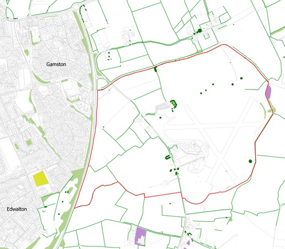
Key:
- Allocation boundary - red line
- Gamston District Centre - pink zone
- Nearby settlements - grey zones
- Existing hospital and other commercial uses - purple zone
- Woodland - green areas
- Key open space - grey/green zone
- Employment - light blue zone
- Watercourse - blue line
- Public right of way - orange dotted line
- Pedestrian or cycleway - purple dashed line
- Listed buildings (Pillboxes) - red triangles
- The green edge - green blocks
- Airfield runway - broken green line
- Access points (subject to detailed transport work) - red circles and arrows
4. Development Framework
Introduction
4.1. The Allocation Framework Masterplan (Figure 38) sets out key structuring principles for the development that will help to inform and guide subsequent stages, such as a Site Wide Design Code, Infrastructure table and planning applications.
4.2 The land allocated for development in the Local Plan is owned by several parties, so this document builds up a holistic framework and seeks to ensure a comprehensive form of development. All current and future parcels within the allocation boundary should, unless otherwise agreed by the Local Authority through the consideration of revisions to any legal agreements or planning permissions, be based on the Land Use Plan and Framework Masterplan (Figures 21 and 38) to ensure individual developments come forward and are delivered as part of a coherent vision.
4.3. The themes of the Allocation Framework are:
- Land Uses;
- Green and Blue Infrastructure;
- Movement Framework;
- Character; Sustainability.
4.4. Each thematic element of the Development Framework builds on the policy requirements set out in Section 01 of this SPD, which in turn build on the requirements of Policy 25 of the Rushcliffe Local Plan Part 1: Core Strategy (Core Strategy) and the Policies (including Policy 3) in the emerging Greater Nottingham Strategic Plan (and any plans that supersede them. These themes focus primarily on the provision of guidance that will inform subsequent planning applications.
Design Objectives
4.5. The design objectives are listed below. They are based upon best practice and planning policy.
- To create an attractive new neighbourhood with a distinct character and identity.
- To promote high quality architecture and place making.
- To integrate the new neighbourhood with the built-up part of Nottingham/Gamston whilst also sensitively considering the surrounding villages, particularly (but not exclusively) Tollerton.
- To deliver a sustainable and environmentally responsible development.
- To develop and enhance the site’s natural assets, such as Grantham Canal, whilst delivering ecological enhancements.
- To protect and incorporate the Grade II listed pillboxes and have regard to the historic alignment of the airport runways.
- To respect the surrounding landscape and provide new green infrastructure, including achieving policy objectives.
- To create a development which allows for appropriate phasing of homes, employment and supporting infrastructure.
- Deliver health and well-being benefits for the proposed and nearby residents.
Design Objectives - The following diagrams explain the key design principles and objectives to inform the Allocation Framework Materplan. These reflect the specific spatial consideration of the site, and the feedback received from the engagement process.
Community 'Hearts'
Create two beating ‘Hearts’ at the centre of the development which contains the key social, community, sports and educational facilities required to deliver on the sustainability agenda. The Neighbourhood Centres will contain retail, healthcare and community uses, possibly linked to the existing Spire Nottingham Hospital and existing Employment uses (depending on how they change as a result of the airfield ceasing to operate). The proposed education on site are located in close proximity to the two ‘hearts’ of the development.
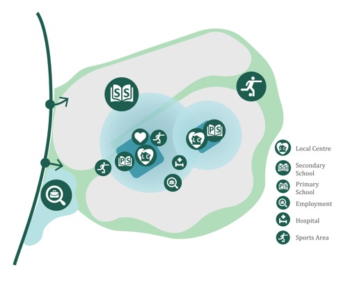
Key
- Local Centre - LC icon
- Secondary School - book icon
- Employment - briefcase in a magnifying glass icon
- Hospital - bed with cross above icon
- Sports Area - football player icon
The 'Edges'
The outer edges will be defined through different landscape typologies and setting the development positively within the existing context. Water Meadows (east) which borders the Polser Brook will contain much of the required drainage attenuation features and deliver a more naturalistic informal ‘water based’ landscape character for habitat creation and biodiversity gain. The Woodland View (south) will deliver a series of new woodland blocks and connecting hedgerow elements to enclose the proposed development and create visual separation to Tollerton village.
Key
- Canalside
- Water Meadows
- Woodland View
East-West 'Greenway'
The creation of an East-West ‘green’ connection will be achieved by linking the existing community of Gamston to the west of the A52(T) with the existing Public Right of Way (PRoW) and then eastwards through the three Sports parks and, in the western edge of the development into the Pillbox Park. Connections into existing movement networks on the edge of the development site will be utilised as well. This park will be a large public space incorporating the heritage assets of the retained WWII pillboxes, which importantly needs to be viewed together as one entity.
Map shows possible location of:
- Sports area - football player icon
- NEAP (Neighbourhood Equipped Area for Play) - frame and slide icon
- LEAP (Local Equipped Area for Play) - see-saw icon
- Leisure park - trees icon
- Ecology area - butterfly icon
- Heritage features - pillbox and trees icon
- Trail - path and trees icon
Density
A density strategy that concentrates high density living around the urban core of the Neighbourhood Centre and spreads outwards in all directions to deliver the lowest densities adjacent to the most sensitive environmental areas at the eastern edges of the development area.
Key
- Centre - red
- High density area - orange
- Medium density area - light orange
- Low density area - yellow
Liner Parks
The creation of a north-south ‘green’ connection will be achieved through utilising and enhancing the existing heritage assets on site, i.e. the runway alignments. Creating a ‘runway park’, a linear park stretching from the northern boundary to the southern boundary of the site. This is in addition to the retention of the existing public right of way from Gamston through to Tollerton will create new public routes, into, though, and out of the site.

Health and Wellbeing
The creation of a dedicated footpath and cycle track network in the form of a circular fitness trail, together with formal sports provision will help deliver the health & wellbeing objectives which are core to the allocation objectives. Opportunities to connect into existing movement corridors outside of the site will be made at all possible locations. The Central Sports Park is to be the most intensely used, supported by two further sports parks to the east and west. The sports facilities within the proposed Secondary School may also be delivered as a shared community resource, although they cannot be relied upon to deliver the required facilities for the residents of the community.
Key
- Sports area - football player icon
- School - book icon
- Trail - green dashed line
Movement and Circulation
The movement, connectivity and circulation strategy for the development will be based upon the delivery of two new access points from the A52(T). These junctions then link together with a ‘figure of eight’ shaped Primary Street which will provide access to all parts of the development. Importantly Tollerton Lane itself will be downgraded south of the Spire Nottingham Hospital. This will discourage ‘rat running’ through Tollerton village by design.
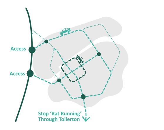
Neighbourhood Areas
The density strategy and the primary street framework provides the basis for defining the ‘structural character elements’ of the development. These are required in order to deliver a degree of variety and character within the development areas and they help to define the three separate neighbourhoods. The three neighbourhoods give it an organised, navigable and recognisable development structure.
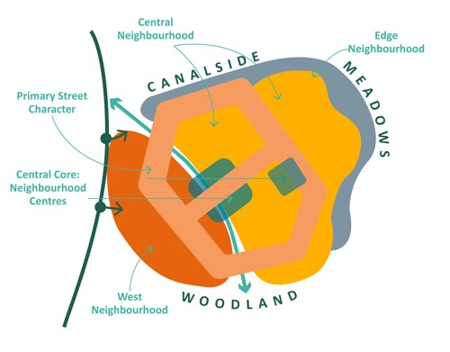
Key
- Central Core - neighbourhood - green zones
- West neighbourhood - orange zones
- East neighbourhood - yellow zones
Land Uses
4.6. The development allocation is expected to deliver around 4,000 homes, 20 hectares of employment in total (of which 13.15 hectares is new employment in addition to the existing employment site within the centre of the site) schools, neighbourhood centres, all encapsulated by, a comprehensive green and blue infrastructure to contain natural features and amenities. The existing employment facilities currently associated with the airport may evolve and / or be redeveloped once the airfield ceases to operate and any changes to the employment activities on this existing part of the allocation would also be expected to contribute (proportionally) to the delivery of the appropriate wider infrastructure associated with those new employment activities (i.e. not education).
Residential
4.7. To maintain a mixed and balanced community, the development needs to provide a wide variety of new homes, including different types, tenures and sizes. These will range from 1 to 5 bedroom properties, including apartments, terraced units, semi-detached, detached houses and bungalows.
4.8. The development shall provide affordable homes with a mixture of tenures informed by the appropriate evidence base and relevant policies. The proportion of affordable homes will be in accordance with prevailing policy requirements, need and evenly distributed in an appropriate phased manner across the allocation.
4.9. In accordance with Local Plan requirement this site is expected to provide 30% affordable housing. The Greater Nottingham and Ashfield Housing Needs Update (March 2024) provides the latest evidence on affordable housing need, including the need for various tenures. In line with the Housing Needs Update, the following tenure mix will be required:
- 25% Affordable Home Ownership
- 75% Rented (37.5% Social Rent, 37.5% Affordable Rent).
However, this will be reviewed and assessed as part of the planning process and secured as part of the S106 agreement(s). In line with the requirements at the time.
4.10. individual site within the allocation unless the local planning authority is satisfied by robust financial viability evidence that development would not be financially viable at the relevant target level. The Section of this SPD titled “Viability” provides further details as to the viability evidence that the local planning authority will expect to be provided if a request is made to reduce the overall affordable housing requirements from that set out here.
4.11. The specific provision and mix of a site will be informed by evidence available at the time of application.
4.12. In accordance with the Local Authority’s Housing Needs Update report, the LPA also requires 5% of dwellings on schemes of 100 dwellings or more to be M4[3][A] [wheelchair adaptable] compliant. On a scheme of 4,000 dwellings this equates to 200 dwellings.
4.13. As with the provision of new employment facilities on the existing employment site, and housing delivery on existing land (such as equine paddocks, and/or through the re-development of existing residential properties within the site), these would be expected to make proportionate contributions towards the wider delivery of the site’s infrastructure (roads, drainage, educations, libraries, green and blue infrastructure BNG etc.) to facilitate these sites being brought forward.
Neighbourhood Centres and Community Hub
4.14. To create a sustainable development, two neighbourhood centres shall be created to provide a range of facilities. The centres shall include retail opportunities, such as a small supermarket and other smaller units, alongside community uses. These uses will meet the day-to-day needs of the residents and can also be used by existing residents and those within the wider area, including visitors and staff of Spire Hospital and adjoining commercial uses. The new neighbourhood centres should be integrated within the development and accessible to all.
4.15. The new neighbourhood centres should form the ‘Heart’ of the new community integrated within the development. They should be an active and prominent part of the development with their locations carefully considered such that they benefit from passing trade/visibility from Tollerton Lane and other routes through the development.
4.16. The ground floors of the Neighbourhood Centres are expected to consist of a variety of uses to serve the development with apartments / residential uses and office uses also acceptable in upper floors to increase vibrancy and provide continuous natural surveillance. The Neighbourhood Centres should be accessible, and active hubs. Education
4.17. The allocation site will provide two primary schools, both 2FE (two-form entry) with appropriately sized nurseries and one sixth form secondary school identified in Figure 21.
4.18. The secondary school is to be provided as further described in the next pages of this document under Secondary School.
Gypsy & Traveller Pitches
4.19. To provide homes for all, the site is required to provide a site for gypsy and traveller pitches to help meet identified needs. Provision should be a site of the provision of 8 serviced pitches with any appropriate facilities (such as but not limited to wash houses) also provided on site, and it should be delivered within the site in the location as illustrated on the framework masterplan. The exact location and size of the site will be established as part of the details for the planning application(s) relating to that land parcel.
Specialist Housing
4.20. An appropriate range of specialist housing, including options for senior living should be included within development proposals, informed by evidence of need.
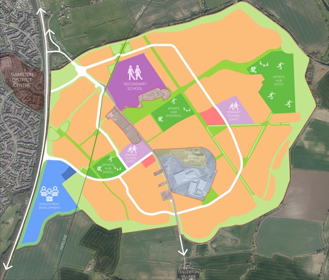
Key
- Residential development - orange
- Neighbourhood centre - pink
- Purple - secondary school
- Lilac - Primary schools
- Light blue - employment
- Light green - healthcare
- Beige - existing residential development
- Dark blue - potential Gypsy and Traveller Site
- Dark green - formal sports, play and allotments
- Bright green - parks and amenity space
- Light green around the perimeter of the site - natural green space including areas of water attenuation
Employment
4.21. An area to the south-west within the allocation has been identified as new employment land and should include a variety of business and employment uses at all scales.
4.22. The location of a new business park will be created, Here, it will have swift access onto the strategic road network whilst having less impact on residential areas. It will be accessed directly from the sites proposed Primary Street, directly adjoining the A52(T). Its location means that will be less susceptible to noise from the A52(T).
4.23. The Employment Areas will provide jobs for the new residents and existing residents of Nottingham and the surrounding area.
4.24. A robust landscape strategy must be in place, to ensure a buffer to the A52, minimise visual impact and create a welcoming and naturalistic environment. The existing employment site may also be redeveloped if the units with businesses currently associated with the airport change occupiers or uses. Any redevelopment or changes of use of this “existing employment” would also be expected to contribute towards the appropriate infrastructure (i.e., not education) to facilitate the delivery of the wider site.
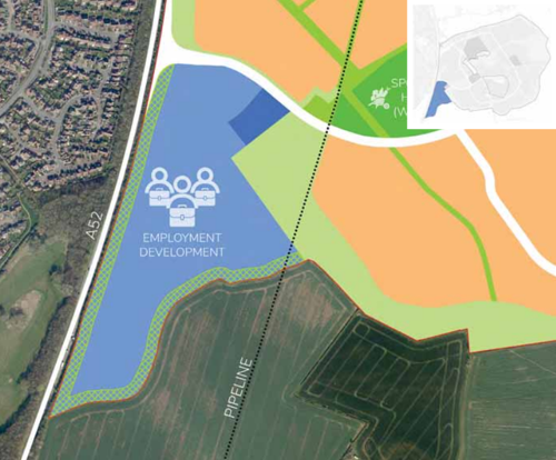
Secondary School
4.25. The site allocation provides land for a new 4FE+ secondary school and sixth form located to the west of Tollerton Lane and within walking distance of most of the new residents. The school will be located close to the main primary movement corridors and accessible by sustainable modes of transport as well as private and public transport. It is linked to a series of pedestrian and cycle routes which are well connected to the proposed open space and residential neighbourhoods. An access for grounds maintenance would also be included to the east of the school site (subject to detailed design).
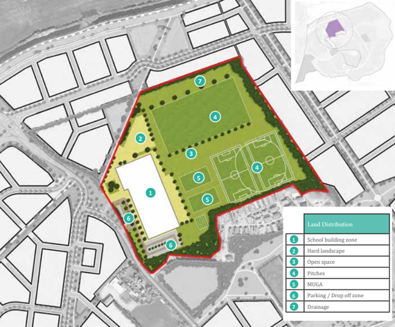
Key
- School building zone
- Hard landscape
- Open space
- Pitches
- MUGA
- Parking and drop-off zone
- Drainage
4.26. The school will require several components in discussion with the Education Authority, but these are likely to include the following as a minimum:
- Core facilities;
- Classrooms;
- Sports hall;
- Assembly hall;
- Kitchens and dining facilities;
- Drop off / pick up point;
- Staff car parking;
- Sports pitches;
- Multi-Use Games Area (MUGA);
- Surface water attenuation area;
- Transport Assessment of its own to assess traffic impact and parking demand requirements; and
- Any easement required for the pipeline.
4.27. The key elements to consider in the design and delivery of the secondary school site are:
- Work with the existing topography of the site. However, the site is likely to need re-grading, and a platform approach could address that issue to accommodate uses such as the school building and pitches. These platforms could then be re-graded back to the existing levels to create a more naturalistic landscape setting. The delivery of a levelled and plateaued (as necessary) serviced site for the delivery of the secondary school will be provided (to the specifications provided by the education authority) as part of the infrastructure delivery for the wider site.
- The effective use of planting on site to help with levels and land use separation, prioritising on site safety is also expected as part of the detailed design.
- The relationship with surrounding uses including Tollerton Park.
- Appropriate provision of land and suitable separation from the pipeline as per the legislative requirements, whilst ensuring suitable, usable areas of land are provided for educational needs.
Primary Schools
4.28. The site allocation also provides land for two new 2FE (two form-entry) primary schools with appropriately sized nursery, one located on the western side of Tollerton Lane, broadly opposite the Spire Hospital site. The other Primary School site is located to the north of the runways within the airfield, towards the north-eastern edge of the site. The locations of the Primary Schools are such that they would be within walking distance of most of the new residents. The schools will be located close to the main primary movement corridors and accessible by sustainable modes of transport as well as private and public transport. Their locations are to be linked to a series of pedestrian and cycle routes which are well connected to the proposed open space and residential neighbourhoods. Access for grounds maintenance would also be included to both the Primary School sites (subject to detailed design).
4.29. The Primary schools will require several components on each of the two sites in discussion with the Education Authority, but these are likely to include the following as a minimum:
- Core facilities;
- Classrooms;
- Sports / Assembly Hall;
- Dining Facilities and kitchens;
- Drop off / pick up point;
- Staff car parking;
- Sports pitches;
- MUGA / outdoor Play facilities;
- Surface water attenuation area;
- Transport Assessment of their own (for each Primary School) to assess traffic impact and parking demand requirements; and
- For the Primary School to the west of Tollerton Lane, possibly an easement required for the pipeline.
4.30. As with the Secondary School, both the primary schools will require delivery of a levelled and plateaued (as necessary) serviced site for the delivery of the primary schools (to the specifications provided by the education authority) as part of the infrastructure delivery for the wider site if the education authority is expected to deliver the primary school(s).
Blue and Green Infrastructure
4.31. The Open Space Strategy Plan (Figure 24) has been developed in response to the wider context and the overall connectivity of the Site (also refer to Figure 34 for the access and movement strategy). The extensive Green Infrastructure shall encompass almost 65 hectares of green space, meeting the requirement of multi-functional space set out in Appendix D (Green Infrastructure) of Local Plan Policy 35 and identifies the strategic corridors and the connecting local corridors and ecological networks within the Borough. Key elements should include:
- Retention of existing vegetation along the Grantham Canal and site boundaries save for where new connections between the site and neighbouring movement corridors are to be formed.
- A continuous green buffer along the A52(T) Gamston Lings Bar Road, Grantham Canal and along the southern boundary of the site allocation save for where new connections between the site and neighbouring movement corridors are to be formed.
- Providing good pedestrian and cycle connectivity for new and existing residents through delivery of green corridors which connect the existing urban edge to nearby Gamston as well as to the surrounding countryside.
- A wide range of recreation facilities, including a network of footpaths and cycle tracks, sports provision, play areas and trim trails.
- Reference to the site’s past, reflecting the alignment of the runways, and incorporating pillboxes and any air raid shelter(s) into green corridors.
- New tree planting along the southern edge of the site to filter views into the development from the south.
- A network of drainage attenuation basins, generally located around the edge of the site will be designed to address any flooding matters and also to address the Biodiversity Net Gain requirements by providing a variety of landscape led design solutions including the use of both permanent water and dry basins; increasing the variety of habitat typologies.
4.32. Based on this, the following focus areas have been identified:
- Blue Infrastructure - this relates to existing and proposed blue infrastructure within and adjacent to the site;
- Woodlands and Contours - this includes the potential for multifunctional planting and woodland, as well as utilising the site’s contours to inform development, however it should be noted that not all public accessible open areas may contribute towards the Biodiversity Net Gain requirement as some uses may conflict with one another;
- Green Corridors - this relates to the opportunity of creating a green network of open spaces to increase access to the landscape and providing connected habitats again noting that access to ecological areas by humans may impact the suitability of any habitat areas and its potential to count towards the Biodiversity Net Gain requirements;
- Connectivity - this includes the requirement to create an additional network of footpaths through the site to link and connect to the wider area, and attractive recreational routes and/or leisure routes to facilitate active travel within the site and beyond;
- Key Retained Features - this includes the requirement to enhance retained features, including the site’s contours (save for any works required around the school sites) and existing vegetation, Grantham Canal, footpaths, and the alignment of the former runway and pillboxes;
- Green Hub - this relates to the requirement to create a formal sports park at the heart of the development, supported and linked to neighbouring green assets including the proposed Runway and Pillbox Parks;
- Sports & Play - this relates to the requirement to provide a variety of sports and play facilities that are accessible to all, suited to their location within the site, and accommodating a diverse range of needs; and
- The Edge Treatments - this relates to the creation of three key edges of distinct character, relating and responding to adjacent natural assets and the surrounding landscape.
4.33. The following pages provide an overview of the key principles and opportunities required for these areas.
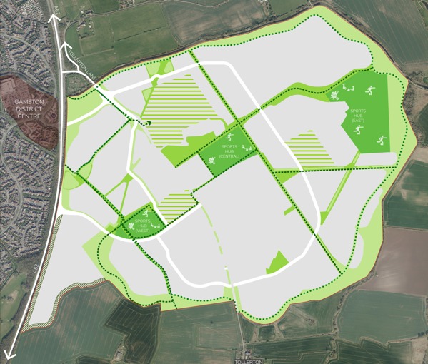
Key
- Proposed leisure trail - dark blue dots
- Strategic foot or cycle track network, active travel corridors - green dashed line
- Formal sports, play and allotments - dark green zones
- Parks and amenity, and allotment space - medium green zones
- Area to include School Sports / Playing Fields - green hatched zones
- Natural green space including areas of water attenuation - light green zones
- Landscape buffer to employment - grey cross hatched line
Indicative Open Space Cross Sections
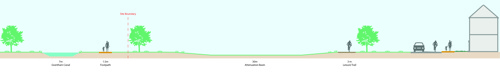
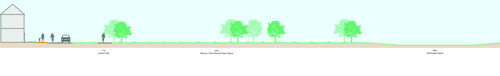
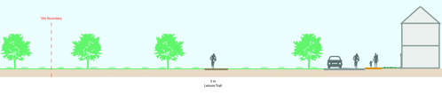
Heart of Development / Central Hub
- Creation of a formal sports park within the centre of the site.
- New destination play areas/formal recreation and central sports facilities.
- The centre of the site is a location where a number of green assets will converge including “The Runway” and “Pillbox Park”.
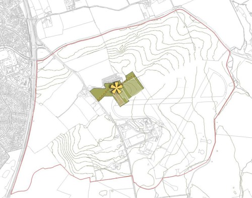
Green Infrastructure
- Incorporating (and supplementing where necessary) existing vegetation along the canal and A52(T) boundaries helps to soften views into the site.
- Create new blocks of woodland and other planting to help soften the impacts of development on views towards the site from Tollerton.
- New and existing vegetation forming a boundary around the site.
- Blocks of woodland help to create an additional green infrastructure and establish tree cover where this is currently lacking.
- Retain existing hedgerow planting, save for new access/connection points to existing movement corridors, to enable the proposed green infrastructure to build upon the existing landscape.
- Green Infrastructure will create a network of new and existing footpaths and routes to connect through, and into the existing networks surrounding/adjoining, the site.
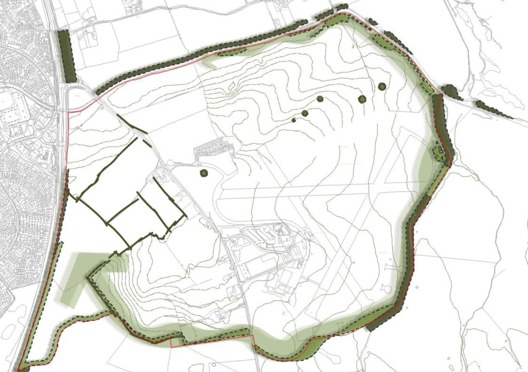
The Edge Treatment
The edges of the built development will have distinct characters within the sites boundaries. High level details are set out below but will be covered in more detail in the Site-Specific Design Code Section of this document. ‘
- Water Meadows’ will create a natural and open character with wetland habitats.
- ‘Woodland Edge’ will introduce a vegetated character with native woodland and scrubland blocks within the site.
- Most of the drainage attenuation will be provided within these edge areas, and around the perimeter of the allocation site.
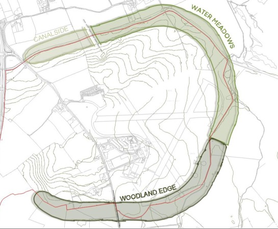
Heritage
- The alignment of the former runways will be retained and enhanced, creating a linear ‘Runway Park’ through the centre of the site.
- The retained pillboxes will be set within a green corridor to be known as ‘Pillbox Park’. The Grade II listed pillboxes will be retained across the site and set within green corridors, that will connect these features, enabling their use and location to be understood through the provision of information boards. Established trees around these pillboxes will also be incorporated into the green space where they don’t conflict with the need to retain the pillboxes.
- New pocket parks/green spaces will be created at key locations with the development.
Connectivity
- Provide an additional network of footpaths within the site to link into the existing wider network.
- Provide connections onto the Grantham Canal towpath and existing Gamston - Cotgrave footpath.
- Recreational leisure routes provide opportunities for walking, cycling, and horse riding.
Key
- Existing footpath - green dots
- Proposed leisure trail (pedestrian, cycle and equestrian) - orange dots
- Active Travel Corridor link - double arrow
Sports & Play
- A number of play and sports facilities will be created across the site, all in accordance with the Borough Council’s Play Strategy (or any documents that may supersede it).
- Formal and informal play areas will be positioned to allow most residents to travel on foot within 5 minutes to the nearest play space(s).
- Style of play facility will vary across the site depending on location, all in accordance with the Borough Council’s Play Strategy (and any documents that may supersede it).
- Play features located around the site’s boundary should be natural and informal, becoming more structured and formal as you move towards the centre of the site.
Key
- Neighbourhood Equipped Play Area (NEAP) - yellow flower
- Local Equipped Play Area (LEAP) - pink flower
- Natural Play / Trim Trail - small purple flower
- Sports pitches - green areas
Sports provision
4.34. The population of the proposed development of around 4,000 homes is identified as 9200 residents (2.3 x 4000) in the overall allocation.
4.35. This increased population is of such a significant quantum that it will generate additional demand for parks, playing fields and open spaces and community hall provision which cannot be met by existing provision, thereby creating deficiencies in facility provision. In accordance with the NPPF, Rushcliffe Borough Council use localised evidence per 1,000 population to evaluate the level of provision per development.
4.36. A copy of the current leisure facilities strategy can be found here: Leisure Strategy Mid-point Review 2022 and the current Play Strategy - Rushcliffe Borough Council.
4.37. An indication of the demand generated for indoor sports facilities that will be generated by this development for sports halls and other sporting facilities such as swimming pools can be generated using Sport England’s Sports Facilities Calculator.
4.38. This development would fall into the West Bridgford and Ruddington analysis area as part of the Rushcliffe Playing pitch strategy (PPS). There is currently a shortfall identified in all sports in this area with the exception of netball where demand can be met Borough wide. The Sport England Playing Pitch Demand Calculator (which uses locally derived information/evidence rather than a national standard), should be used to provide an understanding of the levels of demand from the site (and this also links back to the PPS).
4.39. The allocation site will provide 3 sports hubs: Sports East, Sports Central and Sports West. This will include a variety of sports facilities, including approximately 12 football pitches for all ages, an Artificial Grass Pitch (AGP), cricket pitches, 6 Multi-Use Games Areas (MUGA) and 12 tennis courts alongside sports pavilions with associated facilities. Contributions to off-site facilities such as swimming (amongst others) will also be sought through the planning process.
4.40. A community hall capable (incorporating an integrated community partnership library) of accommodating community groups for community engagement events, and future parish council meetings will be provided to serve a development of this size. The community hall must be sufficient in size to accommodate gatherings of at least 150 people (seated) and should be accessible throughout the day and evening. It is expected that the community hall facility to be delivered approximately half-way through the phased development to foster community engagement and allow the new community to come together, reducing the risk of social isolation and loneliness.
4.41. A central sports facility will be positioned at the heart of the site to create a central ‘Green Hub’ where sports, play and recreation come together. The sports parks should have a distinct character in both their appearance and the facilities that are located there. Green corridors are to be located between the 3 sports hubs to allow for all facilities to be accessed by pedestrians and cyclists in a safe and logical manner. Parking provision, on a shared basis with the neighbouring neighbourhood centre, should be provided to make efficient use of land. A separate Transport Assessment for the Sports Provision will be required. Details of the management and maintenance of the sports facilities and associated buildings and car parks will be required as part of the planning process for those facilities.
Play Strategy
4.42. The play provision policy is determined using localised evidence per 1,000 population to determine the provision required per the planning policy guidance. This would mean that 2.3 hectares of play space is needed based on a population of 9,200. The play space will need to be divided into two Neighbourhood Equipped Areas for Play (NEAP) and multiple Local Equipped Area for Play( LEAP)s and Local Area for Play (LAP)s. For unequipped play/ amenity open space 0.55 hectares per 1,000 population is required so for 9,200 residents 5.06 hectares are required.
4.43. A number of play areas will be provided across the site to ensure there is a facility within a 5-minute walk from most new residential dwellings, following The Fields in Trust guidance for sport and play. The central play space will provide a hub, creating a destination for play.
4.44. Play areas within close proximity to residential areas will have a more informal feel. These play areas need to respect the surrounding residential areas with appropriate offsets to dwellings. The play features located around the perimeter landscape should be natural and informal, encouraging imaginative play. These elements will be set out as a trail, encouraging users to explore the site in its entirety.
4.45. The majority of the green and blue infrastructure network will be publicly accessible, but it can include a variety of different types of open space and may include school playing pitches. Natural and semi-natural open space should be located within green/blue infrastructure corridors, around the buffers to Tollerton and Bassingfield. Further guidance to assist with the design open space and creating healthy active lifestyles can be found in Sport England’s Active Design guide. The Active Design Checklist provides a useful tool for applying Active Design principles to a specific proposal and assessing the ability to deliver more active and healthier outcomes. The Checklist can be found on the Sport England website.
4.46. New open space and sports facilities must be accessible and designed to avoid any significant loss of amenity to residents, neighbouring uses or biodiversity. The proposed eastern play area therefore will not have floodlit pitches due to the proximity of the site to neighbouring ecological areas, unless evidence is provided that suitable mitigation can be provided to address the relationship. Details for the management and maintenance of the play facilities (formal and informal) and associated buildings/structures and car parks will be required as part of the planning process for those facilities.
Allotments
4.47. The Rushcliffe Borough Council Leisure Facilities Strategy 2017-2027 requires 0.4 hectares of provision for allotments per 1,000 population. Onsite provision of 3.68 hectares for a population of 9,200 is required. Details for the management and maintenance of the allotment facilities and associated buildings and car parks will be required as part of the planning process for those facilities.
Blue Infrastructure
The Grantham Canal runs parallel to the northern boundary of the site, providing an existing network of blue infrastructure.
Attenuation basins will be provided in the lowest areas of the site, providing sustainable urban drainage and opportunities to enhance biodiversity and opportunities to enhance habitat typologies to contribute to Biodiversity Net Gain.
Further, new attenuation basins will sit within green corridors, forming part of the wider Green Infrastructure.
Within the development areas and where landform and levels are appropriate, linear drainage swales within green corridors and street scenes will be provided to store and convey surface water drainage.
Key
- Existing Blue Infrastructure Network - blue lines
- Indicative Attenuation Basin - blue zones
Drainage Strategy
4.48. The drainage strategy, including highway drainage, will be designed so that the site can drain at greenfield run-off rates, with run-off being attenuated in drainage attenuation basins. Drainage attenuation swales and basins will be provided along the northern development edge as part of detailed planning applications in discussion with the appropriate consultees. Foul drainage is likely to require additional infrastructure, the exact design and location of which is to be agreed with Severn Trent Water. Any new foul drainage connections across different land ownerships within the site will be provided without ransom to ensure that the drainage solution can be provided to serve the site as whole and allow the delivery of development without delay.
4.49. Management and maintenance of SuDS will be dealt with by each developer in their respective planning applications and secured via legal agreements and / or conditions (as appropriate).
4.50. Across the allocation site, a robust drainage strategy will be required for the entire site at a high level, drainage for development parcels are to be provided by each developer within the context of the overall SPD framework plan and detail through separate planning to ensure that appropriate mitigation is secured and provided. The drainage attenuation features will make use of the existing topography and man-made features as necessary, pushing run-off into the attenuation features that are primarily located within the periphery landscape.
4.51. The majority of the proposed basins will be designed as dry features and may have multiple functions as both amenity and biodiversity assets, although public access to such features is likely to need to be limited to protect the ecology/habitats, secure Biodiversity Net Gain and on grounds of public safety.
4.52. Permeable surfaces will be used as the default position throughout the development, with any proposed deviations / departures evidenced and justified as part of the relevant planning applications(s). Opportunities for water re-use such as providing water butts for all households, the use of rain gardens and rain chains and other measures to restrict water usage must be incorporated into all forms of built development across the allocation.
4.53. The drainage strategy will be designed to be in line with the Environment Agency’s ‘Flood risk assessments: climate change allowances’ guidance produced in Feb 2016 (unless superseded in which case the most up to date, relevant guidance shall be used).
4.54. Details of the site management and maintenance responsibilities of the site wide infrastructure (central hub(s), sports facilities/hubs, green spaces, heritage assets, green infrastructure, formal and informal play areas, blue infrastructure and drainage) will be required as part of the site specific S106 agreement provisions, and phase/plot, specific open spaces, drainage and any other infrastructure features proposed will be required to include details of the management and maintenance responsibilities as part of the relevant planning application submission.
Biodiversity Net Gain
4.55. Biodiversity Net Gain (BNG) will be delivered as part of the development of the site. In England, BNG is mandatory under Schedule 7A of the Town and Country Planning Act 1990 (as inserted by Schedule 14 of the Environment Act 2021). Developers must deliver a minimum BNG of 10%. This means a development will result in more or better-quality natural habitat than there was before development took place. The calculations of these provisions will consider whether the areas are open to the public or not as this may impact on the suitability and use of the areas for BNG if humans and domestic animals can access any proposed BNG areas.
Movement Framework
4.56. The primary objective of the proposed Access and Movement strategy (Figure 33) is to minimise the need to travel by car, and promote trips by modes other than the car, by providing as many key facilities and social uses (and connections to them) on site as possible. The provision of a usable, attractive walking and cycling network is central to the delivery of the scheme. Each phase of the development must be designed to allow public transport, cycle and foot access to the neighbourhoods, and connect to neighbouring phases within the development and provide a fast reliable bus service to Nottingham, from as soon as possible post the first occupations on the allocation.
4.57. Strategic traffic modelling and transport assessment work is being undertaken for the Strategic Allocation to assess the impact of the development and identify means by which to address these impacts on the local and strategic road network. Aspects of potential mitigation are identified in Section 5: Delivery Strategy, of this document. This includes the active involvement of local highways authorities, other transport infrastructure providers and operators, and neighbouring councils, so that the strategy for delivery will support sustainable transport and development at this site.
4.58. Opportunities will be taken to promote sustainable transport modes for all new residents and employees within the development. Safe and suitable access to, through, and onward to locations beyond, the site must be provided for all users. The design of streets, parking areas, other transport elements and the content of associated standards will reflect current national and local guidance, including the National Design Guide and the National Model Design Code.
4.59. Bus stops must be located within walking distance (400 metres) of all residential properties and areas of employment. Bus stops will be provided to a standard (to be agreed with the highway authority) to allow regular bus services to central Nottingham and the surrounding area to operate through the site. Movement Framework Figure 33 outlines the key components of the Access and Movement Strategy for the site and is described in the following pages. The exact locations of the bus stops will be agreed in consultation with the Highway Authority as part of the planning application process.
Mobility Hubs
4.60. The site will accommodate two ‘Mobility Hubs’ to promote sustainable travel. The exact locations of each Mobility Hub will be determined at the detailed design stage and will be based on the prevailing policy/guidance at that time. The approximate locations of the mobility hubs are shown in Figure 33.
Primary Hub
4.61. A Primary Hub will be located in the larger of the two neighbourhood centres, broadly at the centre of the development, broadly in a location along Tollerton Lane north of the existing hospital (subject to detailed design).
4.62. This primary hub will focus on high-volume, high-frequency destinations where all modes meet, with facilities such as (but not limited to):
- Commercial amenities
- Secure weather-protected bike parking for private and shared micro-mobility (such as e-bikes), with electric charging points
- Cargo bike parking
- Bike pump and tool stations
- E-scooter rental / parking (the infrastructure will be provided based on the prevailing policy/guidance at the time)
- Bus stops / infrastructure / real-time information
- EV-charging bays
- Car club bays
- Day use lockers and package delivery lockers
- Loading areas for taxis / private hire vehicles.
Secondary Hub
4.63. The secondary hub will be located on, or near to the primary street located in the eastern part of the development as part of the smaller of the two neighbourhood centres, with facilities such as (but not limited to):
- Bike parking for private and shared micro-mobility (such as e-bikes), with electric charging points
- Bike pump and tool station
- E-scooter parking
- Bus shelters and real-time information
- Package delivery lockers
- Loading areas for taxis / private hire.
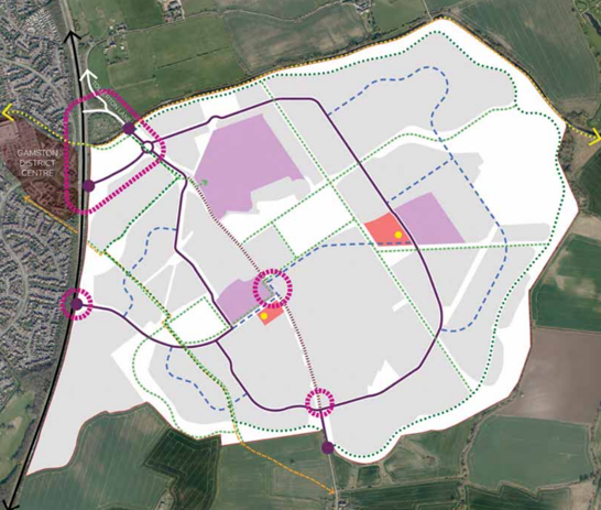
Key
- Proposed junctions - all design layouts to be confirmed - pink circles
- Proposed vehicle access points to site - black dots
- Grantham Canal cycle / bridleway - light green dots
- Proposed leisure trail - dark blue dots
- Existing public rights of way - orange dashed line
- Primary vehicle movement and active travel corridor - purple line
- Primary vehicle movement and active travel corridor - blue dashed line
- Strategic foot or cycle track network, active travel corridors - green dashed line
- School provision - lilac blocks
- Neighbourhood centre and mobility hub - pink blocks
Primary Streets
4.64. Primary Streets will form the main movement routes into the Site for all modes of transport including buses. These streets will include a mixture of dedicated and segregated cycle track and pedestrian footpath which will be separated from the carriageway by a continuous avenue of tree planting. Provision will be made for bus stops along the route of Primary Streets. Junctions will be designed in such a way that priority, where safe to do so, will be given to pedestrians then cyclists, not cars. To provide enclosure, buildings will range from 2 to 3 storeys in height, with 3 storey dwellings in key locations with drives set back from the pavement edge.
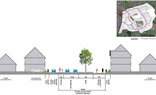
Summary
- Continuous tree lined streets with grass verge and planting.
- Continuous cycle route with minimised access to driveways to avoid crossovers.
- Buildings setback with drives or rear parking with limited direct access.
- Consistent building line and public realm materials.
- Demarcation within shared spaces for pedestrian traffic.
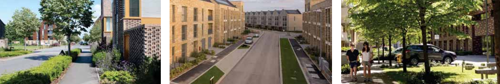
Secondary Streets
4.65. The Secondary Streets provide access to residential neighbourhoods (from the Primary Street(s)) with footpaths. These streets will be narrower than Primary Streets with trees planted regularly. Predominantly Detached/ Semi-detached houses of two to three storey dwellings with defined boundary treatments will provide street enclosure.
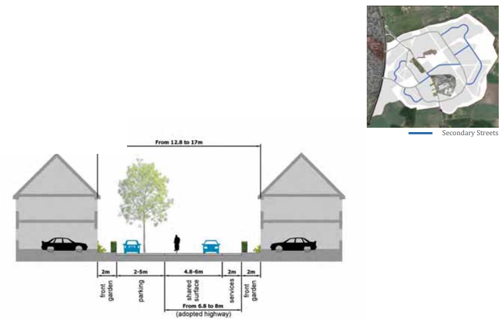
Summary
- Tree planting between parking bays.
- Short terraces with front access and on-plot parking with well-defined boundaries to provide enclosure.
- Consistent building line and materials will help legibility and navigation.
- Demarcation within shared spaces for pedestrian traffic.
Public Transport
4.66. The full, site wide public transport strategy (PTS) is still being developed. However, it will comprise a combination of the enhancement of existing bus services (the 33 and 5/7) and the provision of a new direct bus service into Nottingham City Centre providing a service with an anticipated frequency of service of around every ten minutes. The strategy includes a combination of extending and enhancing existing services through the proposed development site to deliver a frequent service with bus stops located within 400 metres of every dwelling. The PTS will be provided (for the entire site) by the first applicants, working in conjunction with all the landowners prior to the determination of the first planning application and will form part of the sitewide legal agreement (Framework 106 or F106) agreement to ensure that all future / subsequent planning applications will provide a site-specific transport strategy which accords with the PTS. The PTS should also identify the need for interim arrangement for layover facilities for operators to facilitate early delivery of a bus service for the early occupiers of the Site.
Active Travel
4.67. New junctions into the site will incorporate a number of crossing facilities to enable residents to access the existing Gamston local centre to the west of the A52(T). A segregated two-way cycle track will be delivered along Primary Streets through the development, with a shared footway/cycle track provided, unless departures from this requirement have been demonstrated to the Highway, and Local Planning Authorities. The proposals must have been informed by Active Travel principles. All future planning applications must demonstrate compliance with the same principles.
Vehicular Movement and Access Strategy
4.68. The first phases of development will be accessed via the Tollerton Lane junction with the A52(T), following works to improve the junction onto the A52(T). Two new junctions will be delivered as part of the wider allocation site, directly from the A52(T). The form of these junctions will be determined through the planning application process.
4.69. Vehicles travelling north and southbound along Tollerton Lane will be redirected through the western parcel to join a new primary vehicular movement and active travel corridor. The existing Tollerton Lane will be subject to measures, including a bus priority (s), to be provided to discourage its continued use of Tollerton Lane as a through-route bypassing Wheatcroft Island (Roundabout) on the A52(T). The timing of the delivery of these requirements and any limitations on the number of occupations prior to new accesses being provided will be specified in the framework legal agreement.
4.70. A number of interventions will be provided at junctions and along the carriageways within the development site to ensure design speeds of 20mph. The Primary Roads will be limited to 30mph. The internal layout will be designed with consideration to ‘Manual for Streets’ (or any subsequent document should it be superseded) and the Highway Authority’s “Highway Design Guide” and must include traffic calming features throughout the site.
4.71. The capacity of the existing local and strategic highway networks have been modelled using strategic and microsimulation modelling software, and the scope of that assessment was agreed with Highways England and in part by Nottinghamshire County Council. The development will be required to contribute to improvements at a number of off-site junctions associated with the Memorandum of Understanding for A52/A606 improvement package, Developer contribution strategy between the Local Planning Authority, the Highway Authority and National Highways (MOU) (including, but not limited to):
- A52/A453 Silverdale junction;
- A52/A60 Nottingham Knight junction;
- A52/A606 Wheatcroft junction;
- A606/Tollerton Lane/Main Road junctions; and
- A52/A6011 Gamston junction.
4.72. Measures will be applied on Tollerton Lane and within the village of Tollerton to reduce the level of vehicular traffic travelling through Tollerton village and vice versa, and further deter rat running. The approach works must identify the centre of the village alongside features and landmarks and implement ways to emphasise the essential characteristics ensuring that drivers adapt their speed accordingly. Measures include, but are not limited to, tactics to visually narrow the carriageway to reduce speeds, without the need for artificial bumps, signs and chicanes with all proposals to be agreed with the Highway Authority. The exact details will be reviewed and discussed with the Highway Authority as part of the detailed planning process and secured via section 106 agreement and/or highways agreement obligations.
Emergency and Waste Vehicles
4.73. All junctions into and within the development must be designed to accommodate access by service and emergency vehicles, with swept path analysis being undertaken for all the proposals as part of the planning process. Emergency access points must be provided to any parcels of development that will be accessed from a single access point.
Services and Facilities
4.74. The proposal includes two new neighbourhood centres to meet the day-today needs of the development. Appropriate uses include (but are not limited to): a small supermarket, shops, hairdressers, public house(s) and takeaways. Other community uses, such as (but not limited to) a community hall, GP/medical surgery, and sports pavilions will also be required on-site.
Vehicular Parking
4.75. Parking typologies will vary across the site and will include off-street parking, on-plot parking, on-plot and off-plot parking squares and could potentially include some on-street parking, which if required must be attractively landscaped and safe places which are appropriately overlooked. The scheme will be designed to accommodate current Parking Standards in accordance with discussions with the Highway Authority.
4.76. On-street parking is one way to accommodate parking as part of a balanced solution. Parking on the street can be an efficient use of space and people understand how it works. Similarly, on-plot parking is also a common way of accommodating parking needs generated by development. Unlike rear parking courts, on-street and to a lesser extent on-plot, parking increases activity on the street and between the street and the house. Any on-street parking must be positively designed into the street scene to ensure that it does not dominate the environment or negatively impact the character of the street. For residential development, on-plot parking, or frontage parking courts (depending on the house typology) are the preferred method of parking provision.
4.77. Minimum parking standards must be provided as per the full guidance in the Highway Authority’s Highway Design Guide unless evidence to mitigate the need for such provision can be supplied and agreed upon with the Highway Authority (The Highway Authority’s Highway Design Guide should be referred to in the first instance, although a summary relating to residential parking is provided below which should form a mandatory requirement including Parking is provided below which should form a mandatory including Parking Quantum, Parking Geometry and Parking Layout (positioning)).
Sustainable Transport Strategy
4.78. The diagram opposite (Figure 36) highlights the work of the ‘Copenhagenize Design Company,’ which advises governments and cities on creating more bicycle-friendly urban environments through thoughtful infrastructure, planning, and design.
4.79. Their approach focuses on designing spaces that prioritise pedestrians, cyclists, and public transport users by offering the quickest and most direct routes between destinations, while making private vehicle use less convenient with diversions, altered routes, longer travel times, and consequently higher costs. This strategy encourages people to choose sustainable and active modes of transport, ultimately fostering healthier communities and environments.
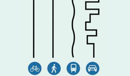
4.80. The Land East of Gamston and North of Tollerton development must take influence from the Copenhagenize Design Co approach in its proposals and sustainable transport strategy, incorporating key elements such as:
- A masterplan that includes two primary schools; a secondary school, sports provision, neighbourhood centres and walkable neighbourhoods;
- Legible (and clearly signed), direct, safe, lit, segregated and surveilled ‘quiet street’ pedestrian and cycle routes that connect in all directions through the site, starting at the centre of the site and link to local services within the site and link into existing networks beyond the development’s boundary including, but not limited to: the existing Gamston Local Centre, the third River Trent River crossing (from The Hook in Lady Bay to the City) and West Bridgford Town Centre.
- Legible (and clearly signed), direct, safe, lit and surveilled cycling routes through and around the development which allow access to local facilities within 10 minutes, and link into existing networks beyond the development’s boundary;
- Direct and safe junctions for all road users, minimising conflicts between vulnerable road users and motor vehicles.
- Gamston Park & Ride – the transport assessment work for the proposed development will need to consider the need for and feasibility of a Park and Ride site. If it is determined that there should be a Park & Ride facility, then a financial contribution shall be required for a detailed design study for the facility and, further to that study, a further reasonable and proportionate financial contribution will be required towards the delivery of that facility and connections to it.
- Direct, safe, lit pedestrian and cycle routes to the County Council’s aspiration for a new ‘Park and Ride’ facility to the North of Gamston Lock.
- A local bus service (as a minimum during peak demand periods) between the SUE and County Council’s aspiration for a new ‘Park and Ride’ facility to the North of Gamston Lock.
- Enhanced bus services providing efficient and attractive travel choice for local connections, that will serve the site, connecting to Gamston and Tollerton and provision of a new bus service direct into Nottingham City, and onward journeys.
- Measures to alleviate traffic routing through adjacent villages to alleviate highway street created and road safety implications.
- Upgrades to, amalgamation of, and formation of new connections into, Public Rights of Way ensuring safe routes are available for all highway users.
- Provision of EV charging points for all developments to allow for the rapid transfer from fossil fuels to electric vehicles over the next 10 years.
Provision of Mobility Hubs that will include:
- Secure weather-protected, secure bike parking for private and shared micro-mobility (such as e-bikes), with electric charging points.
- Cargo bike parking.
- Bike pump and tool stations.
- E-scooter rental / parking (the infrastructure will be provided based on the prevailing policy/guidance at the time).
- Bus stops / infrastructure / real-time information.
- Ev-charging bays.
- Car club /hire/ share bays.
- Day use lockers and package delivery lockers.
- Loading areas for taxis / private hire vehicles.
- Provision of a detailed Travel Plan with incentives to use sustainable modes of transport.
Character
4.81. The proposals will be designed in accordance with best practice urban design principles, including National and local policy requirements set out in the Rushcliffe Local Plan (Part 1 and 2), Rushcliffe Design Code (2025), the National Design Guide (2019) and the National Design Code (and all National and local policy documents that supersede them). A strong character for development is an important placemaking principle as it helps residents feel a sense of belonging, identity and pride in where they live. This can be achieved through layout, massing, landscaping and building appearance along with other details and factors.
4.82. A Site Wide Design Code has been developed as part of this document that sets out high level design code (requirements) for the development as a whole. It must be adhered to for all outline, hybrid and full planning application submissions (and all applications that seek to amend or vary them). Phase specific design codes must be provided as part of the detailed planning applications for the delivery of the site as part of the planning process.
Distinctive Neighbourhoods and Edges
4.83. To deliver variety and character within the development areas, three distinctive neighbourhoods have been identified through an understanding of the Site’s wider landscape context and the relationship to existing urban form. This will require a variation of layout, form and appearance, inspired by a Local Built & Landscape Character analysis, which will be provided to secure a distinctive, high quality design development that responds and integrates with its context.
4.84. A character analysis from the local area will provide an understanding of the context and inform future proposals and must be submitted as part of all Reserved Matters, Hybrid and Full planning applications (and any subsequent applications that seek to vary or amend their approved content).
4.85. Furthermore, special edge conditions within each of the three neighbourhoods will add differentiation to frontages adjacent to areas such as the canal, attenuation areas, Primary streets and woodland areas. These are illustrated in Figure 37 and listed below and will consist of the following:
Character Area 01 Canal Side - This includes the central and internal part of the development within proximity of schools and part of the main spine length.
Character Area 02: Water Meadows- These areas are located to the east, within proximity of water attenuation features within a landscape setting.
Character Area 03: Woodland View - These areas are enclosed by existing and proposed woodlands and include the western and southern parts of the site.
The Primary Street Corridor includes all building frontage adjacent to Primary Street(s).
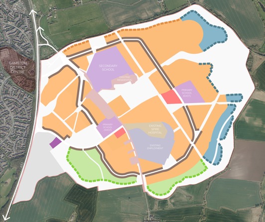
Figure 43. Character Areas Plan
Key
- Meadow Area - blue zones
- Gamston Fields Area - orange zones
- Woodland View - light green zones
- School - lilac zones
- Neighbourhood Centre - pink zones
- Employment - light grey zone
- Potential location for Gypsy and Traveller Pitches - purple zone
- Spine Corridor Frontage - brown lines
- Edge Frontage: Canalside - orange dashed lines
- Edge Frontage: Water Meadows - dark green dashed lines
- Edge Frontage: Woodland Edge - light green dashed lines
- Existing Residential - beige
- Existing Spire Hospital - light brown
- Existing Employment - grey
Sustainability
4.86. The proposed development will provide social and economic benefits whilst protecting (and enhancing) the environment and mitigating and adapting to the effects of climate change.
Environmental Protection and Enhancement
4.87. Through a range of design measures the development will protect and enhance the local environment, including:
- Homes designed to make use of sustainable materials, prioritising the use of local materials, as well as utilising construction methods which reduce resource use.
- Biodiversity Management Plans which include measures to mitigate and enhance the biodiversity of the site, having due regard to biodiversity measures which may have been approved in previous applications.
- Measures to enhance sustainable travel including the provision of electric vehicle charge points at key points and cycle storage in all homes, provision of an extensive network of pedestrian and cycle routes linking to existing off site routes and Public Right of Ways to promote active modes of transport and reduce reliance on the car, as well as a programme of development to improve access to the local bus services and provision of a new direct service to the City.
- Provision of measures through construction and future operation of the site to reduce pollution, minimise waste, and encourage recycling.
Mitigating and Adapting to Climate Change
4.88. The development will incorporate a range of measures to reduce carbon emissions, mitigating the effects of climate change, and adaptation measures to ensure the long-term resilience of the development to the effects of climate change. Measures include:
- Homes designed to reduce carbon emissions in accordance with the energy hierarchy, using a fabric first approach to design to reduce energy demand before making use of low carbon renewable energy, helping mitigate the effects of climate change. The use of green technologies such as solar pv on roofs, grey water recycling and heat-pumps will be used.
- Water consumption of no more than 110 litres per person per day is a required standard of the Rushcliffe Local Plan Part 2.
- Development of new homes in an area of low risk of flooding and provision of a surface water management system and infiltration basins designed to manage a 1 in 100 annual probability plus 40% climate change rainfall event.
- Achieving a net gain in biodiversity (for a minimum of 10%) through the enhancement of existing habitats, creation of new habitats and specification of appropriate climate tolerant species.
- Homes shall be built to the Future Homes Standard (or any such standard that supersedes that standard), so they will not need to be retrofitted with any additional measures or technology to become net zero.
- The Future Homes Standard would see homes fitted with low carbon heating. The expectation is that heat pumps will become the main source of heating systems for all new homes.
- Proposals should be future proofed to embrace up-to-date, new commitments to sustainability. All buildings will be designed to be resilient to climate change and to remain at a comfortable temperature throughout the year. All buildings to have a connection to a smart electric grid which can automatically adjust electricity flows to balance the supply from renewable sources and the grid with demand.
- Carbon reductions will be incorporated into the design of development phases for all forms of development with due regard to the latest legislation and guidance, for example, the fabric first approach and no-carbon heating solutions.
- The proposals will deliver water efficient buildings achieving a residential water efficiency level of 110 litres per person per day. Rainwater storage butts, water meters and low flow water appliances will be provided in all homes and businesses to help future residents and businesses minimise water use.
- Delivery of high-speed broadband and charging points for electric vehicles will be provided for all new dwellings and businesses in the development.
Summary of Sustainability proposals:
- Energy-efficient, low-carbon buildings that are for a community use and for dwellings that front onto Primary Streets;

- All-electric energy; residual emissions will fall over time;
- Enable switch to electric vehicles;
- Walkable / cyclable layout;
- Local facilities that are connected and accessible to reduce the need to travel;
- Space plus telecoms for remote working;
- Retain and enhance natural features for wildlife;
- Streets and parks that invite active travel and active recreation;
- Outdoor sports;
- Allotments;
- Ready for climate change (rainfall, drought, heat);
- Natural flood management;
- Trees for shade;
- Planting for drought;
- Water-efficient buildings.
Allocation Masterplan Framework
4.89. A thorough understanding of the site allocation and its wider context provides the baseline upon which to deliver a comprehensive framework masterplan that demonstrates a holistic approach to design when different parties come forward to submit planning applications in the future.
4.90. The proposals must be focused around a new community heart, including primary education and central sports park set within a liner heritage park which helps promote healthy lifestyles and reacts to (and incorporates) the heritage constraints, including (but not limited to) the listed pillboxes. A strong hierarchy of development blocks, streets and places structured around a network of green infrastructure must be delivered.
4.91. The Allocation Framework Masterplan provides the following:
- Around 4,000 homes, designed and delivered by best practice guidance with energy-efficient, low-carbon dwellings fronting Primary Streets.
- Two Primary Schools and a Secondary School.
- Energy-efficient, low-carbon buildings within the Neighbourhood Centre’s, providing retail, office, medical and community facilities.
- Primary access via the A52(T).
- Safer access to and from Gamston, with suitable pedestrian and cycle crossings.
- Tollerton Lane, to the south of the main access into the site, to be downgraded utilising traffic calming features with improvements to walking and cycling routes, through the site, connecting into existing mobility routes that adjoin the site’s boundaries.
- A new bus service with appropriate infrastructure to serve it, along with improvements to the existing bus infrastructure, will be provided.
- A fully integrated green infrastructure strategy to allow for the provision of significant areas of public open space, play areas, sports pitches, multiuse games areas, and Sustainable Drainage features will be provided.
- Grantham Canal (which bounds the site) must be enhanced to facilitate access to and from a new fitness trail to be provided within the site to encourage outdoor activity and mobility whilst also allowing for the enhancement of wildlife habitats and the screening along the boundary to the site.
- Creation of a new linear parkland utilising the existing runway alignment(s) to help promote healthy lifestyles and form an appropriate setting for the historic pillboxes must be provided.
4.92. The Allocation Framework Plan shown in Figure 38 shows how the site can be developed with a holistic view of the overall development. It provides a framework for the planning applications and structure for the subsequent phased development of the Site. The plan sets out broad land uses and movement strategy but allows for some flexibility with the appropriate justification and evidence for doing so through the appropriate planning process.
Stewardship
4.93. Policy 25 of the Local Plan provides that the development will be subject to requirements which include a neighbourhood centre, community facilities and retail development, improvements to road infrastructure, improvements to walking, cycling and public transport links through and beyond the site, sewage and off-site drainage improvements, an appropriate sustainable drainage system, the creation and enhancement of open space and green infrastructure, the creation of significant green infrastructure areas and buffers and an enhanced green corridor along Grantham Canal and new or expanded educational, outdoor sports and leisure, Gypsy and Traveller provision, health, community, faith, cultural and youth facilities as required by the scale of development. These features must be delivered across the Site.
4.94. These development requirements all relate to the types of spaces, infrastructure and community facilities and assets that are vital elements of the development, and which require long term stewardship and governance to ensure that the components of the development are properly looked after for years to come; this is known as stewardship. Stewardship vehicles help build community place-making reciprocally to help manage and maintain public and private realm, provide and run a range of community facilities and help manage utility services where appropriate.
4.95. A well-thought through active, local, stewardship model will help foster a shared sense of ownership and identity in relation to the development and engender inclusivity and buy-in from residents and businesses. The stewardship model needs to be well-funded (including being set up to deliver regular income streams), self-financing and provide an exceptional quality environment to realise best place-making and a legacy.
4.96. The Town and Country Planning Association recognises the importance of ‘Community ownership of land and long term stewardship of assets’ and their Stewardship Toolkit contains useful information on stewardship approaches for new communities and has also been used to inform the approach in this SPD bringing knowhow and learning from existing communities such as supplementing service charges with other income streams to sustain the viability of the community; different charges for discrete areas in addition to a wider estate charge; being flexible on structure; and engaging with the community.
4.97. The stewardship strategy for the development will need to be of evolving nature as the development progresses.
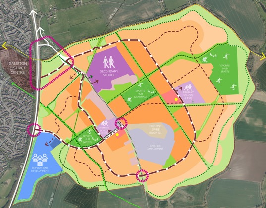
Key
- Proposed junctions - all design layouts to be confirmed - pink circles
- Grantham Canal cycle / bridleway - light green dots
- Proposed leisure trail - dark blue dots
- Existing public rights of way – green dashed line
- Primary vehicle movement and active travel corridor - thick purple dashed line
- Secondary vehicle movement and active travel corridor - thin purple dashed line
- Strategic foot or cycle track network, active travel corridors - green dashed line
- Existing Tollerton Lane Alignment - green vertical bars
- Residential development (high density) - dark orange
- Residential development (medium density) - medium orange
- Residential development (low density) - light orange
- Neighbourhood centre - pink
- Secondary school - purple
- Primary schools - lilac
- Employment - light blue
- Light green - healthcare
- Existing residential development - beige
- Potential Gypsy and Traveller Site - dark blue
- Formal sports, play and allotments - dark green
- Parks and amenity space - bright green
- Natural green space including areas of water attenuation - light green around the perimeter of the site
Stewardship Strategy – requirements for planning applications
4.98. A high quality, comprehensive stewardship strategy for the development is required encompassing a single site-wide strategy rather than separate piecemeal strategies for each individual site that may come forward by sub-developers within the overall site.
4.99. Long term stewardship needs to be considered from the outset of the planning process and planning applications are required to be submitted with a draft stewardship strategy which can further be developed and secured through planning conditions and Section 106 agreement(s). The Section 106 agreement(s) will set out the broad mechanisms and the terms under which community facilities, or land for these facilities, will be funded, managed, leased and/or transferred to the future operators/custodians.
4.100. A phased approach will need to be enshrined in the Section 106 Agreement as regards stewardship of assets in order to identify land and/or assets and facilities in a phase (or relevant plot) that will require ownership and long-term stewardship; the most appropriate governance model to apply to each asset (which, as applicable, may be a stewardship management organisation or a local authority or undertaker); the timing of implementation of transfer of those assets to the chosen governance entity; and any linkages between different assets.
4.101. This approach will, by necessity, develop over time given the long-term nature of the development and as such the S106 agreement obligations will reflect the need for detailed plans for assets to be developed as each phase is brought forward.
4.102. The draft stewardship strategy will need to focus on delivering the following “Overarching Stewardship Outcomes” (including with regard to stakeholder consultation and engagement and the long-term financial resilience and viability of the stewardship body):
Exemplar Community Spirit: The development of strong community spirit in the development for residents and businesses where community members have a strong voice and active involvement and participation.
A Strong nature Based Approach: Provision and enhancement of biodiversity, the natural environment and green and blue infrastructure bringing associated well-being benefits to the community.
Consolidated and Reasonable Service Charge: A single consolidated service charge bill for customers rather than multiple bills for multiple services, with the service charge being reasonable and not excessive level as compared to market norms given the quality and levels of services being provided.
A Sustainable, Resilient and Well Communicated Stewardship Business Plan: A high level of understanding of what to expect and when from the stewardship body. A well communicated business plan which includes the planned income streams for capital expenditure and operational expenditure costs. This supports high quality and successful management, maintenance and development of community facilities and data gathering to enhance efficiency and use of resources and active travel with associated efficient running costs.
Exemplar Community Facilities: The early delivery of high quality community facilities and amenities to help engender a strong sense of community spirit.
Strong Environment, Social and Governance targets and Monitoring: A strong set of environmental, social and governance targets with monitoring of performance.
Collaboration and Inclusiveness: A collaborative, inclusive and diverse approach to exemplar stewardship for residents businesses in the development. This will have a representative and accountable governance structure to develop, deliver and manage stewardship.
Planning for long term stewardship within the draft stewardship strategy
4.103. The stewardship strategy must include details as to the proposed stewardship body or bodies that will be set up to manage and develop the community assets in perpetuity. All opportunities for asset management by a stewardship body will need to be considered and a stewardship working group established. The role and constitutional structure of the stewardship body, together with anticipated income streams to fund the management and maintenance of assets it is responsible for will need to be developed to ensure good governance.
4.104. The stewardship strategy to be provided by the consortium of land owners working together prior to the determination of the first planning application, and must cover details concerning: Master estate-managed serviced areas – these areas will be stewarded by a master estate stewardship organisation which will have a board of directors and voting structure including community participation and engagement and local authority involvement; Sub-developer managed and serviced areas; and Any third-party provider estate management serviced areas (including specialist SUDS, BNG, energy, open space etc.)
4.105. The stewardship strategy will need to include a staged approach to evolve stewardship requirements as the community develops as the development is built out. This will be reviewed at key stages to make the most of new opportunities whilst ensuring that any review is not used as an opportunity to reduce commitments made at the application stage.
4.106. A long term commitment to management and maintenance is required, with a stewardship delivery programme setting out when the more detailed proposals for the stewardship of the phases of the development will come forward.
Paying for long term stewardship
4.107. The stewardship body must be a viable business model and capable of generating a sustainable income and revenue streams from community assets that can be reinvested for the benefit of the community to ensure successful stewardship. Stewardship bodies should be entrepreneurial with money saved through good design and developed as the community grows. Energy-efficient buildings are cheaper to run. Community buildings should be designed to be flexible in terms of their usage and be built to a high quality.
4.108. The stewardship strategy must set out funding arrangements for income generating assets, including those which may only generate an income in the longer term, including commercial floorspace, potentially any surplus biodiversity net gain units, and profit share from an on-site renewable energy micro-grid. Any service and estate charges should be levied at and maintained at a reasonable level that is commensurate with the level of cost that is incurred in maintaining or servicing the relevant assets. Charges must clearly identify the purposes and services for which they are levied to ensure clarity in relation to other charges that occupiers may be responsible for.
4.109. The cost of management and maintenance of the wider development’s places, services, assets, facilities and amenities will need to be covered by a combination of the service and estate management charges that may be levied and other sources of income that may include a range of sources such as community facilities revenues including community hub buildings and space hire revenue, community café income, events income from sports and community facilities and other potential sources.
5. Delivery Strategy
Strategic Infrastructure
5.1. The plan at Figure 41 identifies the strategic infrastructure (including the potential access arrangements described above) which is required to be delivered on-site to support the allocation of the site as a whole. This plan (Figure 41) also shows the current broad land ownership in ‘zones’, which illustrates how certain strategic infrastructure crosses multiple ownerships.
5.2. At this stage, the strategic infrastructure requires both on and off-site works in order to support the site as a whole (the ‘Strategic Infrastructure’). The Strategic Infrastructure comprises the following, although it is acknowledged that this list is indicative only and will be superseded by the Gamston Strategic Urban Extension Infrastructure Delivery Plan (Gamston SUE IDP) when prepared and adopted (see para 5.11, below):
A. On-site infrastructure
- Tollerton Lane works (excluding A52(T) junctions).
- On-site primary infrastructure; including strategic site roads, strategic storm drainage and attenuation ponds and swales and strategic foul drainage including pumping stations and an appropriate sustainable drainage system.
- Acoustic fence along the A52(T) Gamston Lings Bar.
- 2 x 2 Form Entry (FE) primary school both with appropriately sized nurseries and the possibility of on-site.Special Educational Needs (SEN) provision too.
- Sports hubs (including pitches and pavilions) x3 – east, west and central. For future maintenance and management there is a benefit of having fewer buildings, with larger multi-functional sports hubs on the central and east hubs. On the west sports hub, a pavilion building containing toilet, shower and changing facilities will be required.
- The amount of changing rooms and toilet accommodation is directly linked to the number of sports pitches and the sports they serve. However, as a general principle for 5 football pitches, at least 10 changing rooms, one for each team (home and away) and potentially one for officials, depending on the level of play needed. The Football Association (FA) suggests that it’s not always necessary to have a changing room for each pitch, and staggered kick-off times can allow for shared facilities.
- Public Open Space areas; including Strategic Cycle Links / multi-user routes.
- Open space and green infrastructure which links to the wider green infrastructure network, and which has regard to the Greater Nottingham Landscape Character Assessment, and provides for biodiversity enhancements.
- Green Infrastructure areas and buffers particularly on the southern and northern boundaries to contribute to the creation of permanent defensible Green Belt boundaries between the development and the settlements of Tollerton and Bassingfield.
- Creation of an enhanced Green corridor along the Grantham Canal.
- Allotments.
- Neighbourhood Park and Trim Trail.
- Outdoor Tennis Courts.
- Artificial grass pitches (even if this means a reduction in the natural turf pitches available, with a preference for these to be on the central and / or east sports areas), and hockey provision (to be delivered on-site).
- Play areas: Locally Equipped Areas of Play (LEAPs), Neighbourhood Equipped Areas of Play (NEAPs), Muli-Use Games Areas (MUGAs)
- Sustainable Transport Measures (internal Infrastructure)
- Community Library and contributions towards the expansion of existing off- site facilities)
- Upgraded footway/cycleway provision on the entire length of Tollerton Lane through the site, connecting to the village of Tollerton to the south of the Sustainable Urban Extension.
- Improvements to walking, cycling and public transport links through the site.
- Signalised pedestrian/cycle crossings within the allocation site.
- Neighbourhood center(s) - No more than 3,000sqm of (Class E a, b, c, e, g,; Class F1 b, c, d, f; and Class F2 a) (cumulative total) shall be provided on site and no individual unit shall exceed 499sqm in floor space and there shall be no amalgamation of the units defined for the above uses within each of the neighbourhood center(s).
- Community facilities including a Community Hall with a stage, the ability to seat 150 people and other ancillary facilities e.g. toilets, kitchen.
- Pillbox restoration and ongoing management/maintenance. (To ensure that pillboxes are repaired, as well as discussions on illustrative layouts to ensure that the pillboxes are presented within the public open spaces. At least 2x examples of each type of pillbox to be fully restored (NB 1x of the type 22 pillboxes already has been – the one at Spire Hospital) and the rest of the pillboxes stabilised to ensure they don’t deteriorate.One of the type 22 pillboxes and one of the repaired square types should be near each other so that they can be presented as examples with interpretation boards. Whilst there are a couple of closely positioned pairs, it is acknowledged that until the survey work is done the developer(s) (and the Local Planning Authority) won’t know which pair is the most appropriate to receive the appropriate repair treatment(s)).
- Gypsy and traveller pitches x8 (delivery of a flat, levelled and clean (remediated if necessary) site, with all utilities provided to each pitch)
- Public transport.
- Healthcare provision (including a GP surgery) on-site. A site appropriately sized (4,000 dwellings would generate 9,200 new 82 patients based on 2.3 people per dwelling. Based on the British Medical Association (BMA) guidance of 1,700 patients per full time GP this would equate to 5.4 whole time equivalent (WTE) GPs. Associated clinical staff 4 WTE and 10.6 non-clinical staff = 20 full-time practice staff. 2 WTE Additional Roles staff (physiotherapist, social prescriber, mental health, etc). This does not include a commercial pharmacy – this would require an additional 100-150 square metres if located within this building. The total gross internal floor area (GIFA) required would be 954 square metres over two floors (plus pharmacy) to be split circa 2/3 Ground Floor and 1/3 First Floor (636 square metres and 318 square metres respectively) built to all NHS standards in particular Health Building
- Note 11-01: Facilities for primary and community care services HBN11-01 and BREEAM Excellent. A total of 40 car parking spaces would be needed, and the total land requirement would be 0.28 hectares (plus the land required for the pharmacy) with a level surface and with services to the site provided.
- Sports Hall provision - (new or expanded educational, outdoor sports and leisure, health, community, faith, cultural and youth facilities as required by the scale of the development, which is planned in such a way to integrate existing and new communities as required by Policy 25 of the Core Strategy)
- Biodiversity net gain for Strategic Infrastructure
Owing to the high levels of car demand that will be created by the Sustainable Urban Extension, strategic site wide sustainable transport measures to offset / mitigate such impacts will be required which may include (but not limited to) the following and will be informed by the transport assessment(s) carried out as part of the proposed development:
- Mobility hubs, including shared bike / e-bike / e-scooter / mobility schemes, including trunk infrastructure and docking points etc.
- Last Mile Deliveries and Emerging Technologies, drop-off points and pickup points for example.
- Hub Electric Vehicle (EV) charging facilities.
- Gamston SUE specific EV car hire/sharing scheme.
- Gamston SUE specific car barn(s) - These are privately manged covered parking areas, located close to other public transport hubs, where cars or the spaces can be short and long terms leased, they include EV charging.
- Facilities – and reduce the need for roads fronting houses / parking required on plot, they can also cater for some visitor parking.
- Framework Travel Plan and Framework Travel Plan Co-ordinator (for residential and employment).
- Minimum corridor widths for all active travel routes (Pedestrian / Cycle) within the site to encourage and promote their use (i.e. open, wide overlooked routes with no secluded areas).
- Retain the location and alignment of footpath “Tollerton FP6” running through the site and provide connections into it from the surrounding development.
- Provide unrestricted connections to footpaths “Tollerton FP1” and “Tollerton BW9” and the “Grantham Canal Tow Path” that all run along boundaries of the SUE.
- Provide unrestricted connection opportunities to footpaths “Gamston (R) FP13” and “West Bridgford FP15” which are located on the edge of the site, albeit separated from the SUE by the A5 2(T).
B. Off-site infrastructure
- Highway works including A52(T) junctions and active travel improvements.
- Other off-site highway works, including (but not limited to) works within Tollerton village and works to Bassingfield Lane – all off-site works to be identified and refined further through the planning process and in discussion with the highway’s authorities. The development of the site shall mitigate direct impacts on the local road network as determined by the outcome of the transport assessment(s).
- Appropriate measures for, and improvements to, walking, cycling, public transport, Public Rights of Ways, and Junction Improvements/ alterations (off-site,) including off-site junctions and highway links with known safety records in near vicinity to the SUE (which could be numerous dependent on the details proposed by the planning applications / transport assessments) will be provided in agreement with the highway authorities.
- Improvement measures to capacity and safety of pedestrian / cycle / bus infrastructure will be provided in agreement with the highway authorities.
- A package of improvements for A52(T) between the A6005 (QMC) and A46 (Bingham) junctions works identified in the A52(T) / A606 Infrastructure Package covered by the Memorandum of Understanding (MoU) between Highways England (now National Highways), the County Council (The Highways Authority) and the Borough Council dated May 2019, with such adjustments to the works identified in the MoU and the costings set out in the MoU as the highways authorities shall advise.
- Biodiversity net gain for off-site highway works as needed.
- Other community facilities as needed including, but not limited to, swimming pools and household waste recycling.
- Special Educational Needs School Expansion (off-site).
- Gamston Park & Ride – the transport assessment work for the proposed development will need to consider the need for and feasibility of a Park and Ride site. If it is determined that there should be a Park & Ride facility, then a financial contribution shall be required for a detailed design study for the facility and, further to that study, a further reasonable and proportionate financial contribution will be required towards the delivery of that facility and connections to it.
- Sewage and off-site drainage improvements.
5.3. Each planning application for any part of the allocation will be required to:
- Accord with the SPD for that area of land;
- Provide the infrastructure relevant to that area of land (i.e. all site specific, non-Strategic Infrastructure), including an appropriate provision of affordable housing in accordance with Policy and open spaces relevant for that area; and
- Contribute, in proportion to the scale and impact of the development applied for, to the provision of Strategic Infrastructure (see paragraph 5.11 below).
Access and Active Travel
5.4. Access arrangements both to the site (from the A52(T)) and within the site are critical to the delivery of the site. As far as access from the A52(T) is concerned, different access solutions at junctions A, B and C (shown on Figure 41) are currently being discussed with the highways authorities but a decision has not yet been made as to which solution is to be delivered. The broad development approach following construction of the upgraded site access from the A52(T) junction with Tollerton Lane is for parcels to come forward concurrently from several different phases, all accessed from Tollerton Lane. A primary road corridor looping around the eastern and western sides of Tollerton Lane will be delivered phase by phase to serve parcels. The phasing of this will be determined through the planning applications. Access arrangements within the site are also still being discussed with the highways authority but are envisaged to include two loops of a primary road corridor shown as ‘Primary Vehicular Movement & Active Travel Corridor’ on Figure 41 (above), one east of Tollerton Lane and one west of Tollerton Lane. Active travel provision from the site must connect properly to existing active travel infrastructure in the surrounding area. Development proposals will be expected to deliver improvements to the existing active travel provision in the area where necessary to bring such provision in line with current standards.
5.5. At the point that one complete loop of the primary road corridor onto the A52(T) is delivered (either to the east of Tollerton Lane or the west of Tollerton Lane), Tollerton Lane will be downgraded (through measures to first be agreed in conjunction with the highway authorities as part of detailed planning application(s)) and the primary road corridor will become the main route for all vehicles, including buses.
5.6. Works to the A52(T)/Tollerton Lane junction (point A on Figure 45 below) will be delivered early, alongside other highway works which are indicatively identified in the below at Figure 46 but will be refined further through the planning process and discussion with the highway’s authorities and will be set out in an updated Infrastructure Delivery Plan (IDP) for the allocated site which shall be supplemental to the existing and emerging Local Plan IDPs (the ‘Gamston SUE IDP’). These works include off-site highway works and the costings referred to in the 2019 Memorandum of Understanding for A52(T) highway improvements, which may need to be updated.
5.7. All development proposals for parcels of land within the site are expected to be designed to facilitate:
- vehicular and pedestrian/bridleway access to adjacent parcels of land within the site to ensure appropriate site-wide connectivity; and
- access to existing and new footpaths, bridleway and cycleways within and adjacent to the site
5.8. This is to ensure appropriate site-wide connectivity and provide connection opportunities to the wider area on an unrestricted and un-ransomed basis. This will ensure that the allocation can move forward on a viable comprehensive basis. The safeguarding of suitable land for access to adjacent parcels of land will be protected through the framework Section 106 Agreement. The framework Section 106 Agreement will contain similar provisions relating to access to schools – safe and appropriate vehicular, pedestrian and cycle access must be provided to schools from the day they are open, with temporary access arrangements being required if necessary.
Key
- Proposed junctions - all design layouts to be confirmed - pink circles
- Proposed leisure trail - dark blue dots
- Primary vehicle movement and active travel corridor - thick purple dashed line
- Secondary vehicle movement and active travel corridor - thin purple dashed line
- Strategic foot or cycle track network, active travel corridors - green dashed line
- Existing Tollerton Lane Alignment - green vertical bars
- Neighbourhood centre - pink
- Secondary school - purple
- Primary schools - lilac
- Employment - light blue
- Potential Gypsy and Traveller Site - dark blue
- Formal sports, play and allotments - dark green
- Parks and amenity space - bright green
- Natural green space including areas of water attenuation - light green around the perimeter of the site
- Development Zone 1 - within orange boundary line
- Development Zone 2 - within blue boundary line
- Development Zone 3 - within red boundary line
- Development Zone 4 - within purple boundary line
Framework Section 106 Agreement
5.9. Whilst the wider site will be delivered via separate applications, it is essential that the Strategic Infrastructure which is required by the site as a whole in order for the allocation to come forward is delivered in a coordinated manner and that each development parcel contributes towards that Strategic Infrastructure on an equitable and proportionate basis regardless of when those development parcels come forward. This will also provide clarity and certainty for landowners and developers over the planning obligations that they will be expected to enter into.
5.10. The Council considers that the best mechanism for ensuring this objective is achieved will be via a framework Section 106 agreement. Landowners and developers of land within the allocated site will also be expected to enter into equalisation agreements in relation to works in kind (where necessary) and in relation to land on which Strategic Infrastructure is being delivered, so that land values across the site are equalised and the cost of providing land on which Strategic Infrastructure is located (and such land therefore not being available for residential or employment development as a result) is shared fairly and proportionately amongst all landowners and developers regardless of where that Strategic Infrastructure is located within the allocated site. This will be the assumed basis for framework Section 106 agreement requirements.
5.11. The framework Section 106 agreement will be developed by the Council and used as a base template document for all Section 106 agreements relating to the development of any land parcel within the allocated site (save exempt development referred to in paragraph
5.11(J) below). The framework Section 106 agreement will contain a “Part 1” relating to Strategic Infrastructure and a “Part 2” relating to site specific infrastructure and obligations, including affordable housing.
| Item | Infrastructure Type | Infrastructure Description | Trigger |
|---|---|---|---|
| 1 | Vehicular Access | Upgraded A52 / Tollerton Lane junction to signals. | Early delivery |
| 2 | Vehicular Access | Temporary upgrade to A52 / Ambleside junction to signals. Note, the future format of this junction is subject to which Access Scenario is delivered - see below. | Early delivery |
| 3 | Vehicular Access | New access junctions via Tollerton Lane into development parcels. | Early delivery |
| 4 | Active Travel | At grade controlled crossings A52 / Tollerton Lane signals, and shared use provision on the western side of the A52 between the A52 / Tollerton Lane signals and Ambleside | Early delivery |
| 5 | Active Travel | At grade controlled crossings A52 / Ambleside | Early delivery |
| 6 | Active Travel | Upgrade to the existing toucan crossing over the A52 between Tollerton Lane and Gamston roundabout | Early delivery |
| 7 | Active Travel | Upgraded footway / cycleway provision on Tollerton Lane from A52 / Tollerton Lane junction to the entrance to Tollerton village | Early delivery |
| 8 | Active Travel | Improvement to Bassingfield Lane active travel connection to the existing toucan crossing ofver the A52 | 500 dwellings |
| 9 | Public Transport Services | Agreement of service provision | Delivery trigger to be confirmed. Likely requirement for early approval of Public Transport Delivery, setting out a timetable for bus service to become operational. There will be a need for interim arrangements for layover facilities for operators to facilitate delivery of bus service from first occupation. |
| 10 | Public Transport Infrastructure | Bus stops and turning facilities within development parcels as necessary | As above item 9 |
| 11 | Public Transport Infrastructure | Improvements to Tollerton Lane bus infrastructure (carriage widening and bus stop shelters) | As above item 9 |
| 12 | Off-site Highways |
20% indexed linked contribution towards Memorandum of Understanding strategic network improvements (see below) at the following junctions:
|
Early delivery |
| 13 | Off-site Highways | Implementation of traffic in villages approach to Tollerton Village, which could include measure to deter 'rat running' and measures to encourage drivers to adapt their speed accordingly | 500 dwellings |
5.12. The framework Section 106 agreement will state that “Part 1” provisions are expected to be included as standard across all development sites with adjustments limited to those set out in the framework Section 106 agreement. “Part 1” will include the following provisions:
- Payment of Strategic Infrastructure contributions: Developers will be expected to make Section 106 contributions towards Strategic Infrastructure. This Strategic Infrastructure will be identified in the Gamston SUE IDP. The Gamston SUE IDP may be updated by the Council from time to time – see paragraph 5.11(e) below). Some contributions towards Strategic Infrastructure will be payable only in relation to residential development (such as education and healthcare); others will be payable whatever the form of development (such as highways.) The Gamston SUE IDP will set out which type of development is expected to contribute towards each item of Strategic Infrastructure. The amount of contributions payable will be determined by the Council on a consistent and proportionate basis in accordance with regulation 122 of the Community Infrastructure Levy Regulations 2010 (as the same may be amended or replaced) and will be informed by the Gamston SUE IDP an allocation wide assessment of Strategic Infrastructure costs and viability carried out in preparing the Gamston SUE IDP. It is anticipated that contributions will be calculated on a per dwelling basis in relation to residential development and a per square metre basis in relation to employment development. The contributions may be paid in instalments to be agreed in the relevant Section 106 agreement and the payment date(s) for payment contributions will also be agreed in the relevant Section 106 agreement. The contributions may be paid to ‘pots’ which may fund either a single item of Strategic Infrastructure or multiple items of Strategic Infrastructure, at the Council’s discretion. Such contributions shall be payable, where relevant, where the Strategic Infrastructure has been built or provided as at the date the relevant Section 106 agreement is entered into, in order to ensure a proportionate contribution is made by all benefitting development within the allocation. Early delivery of certain items of Strategic Infrastructure may be beneficial or necessary in order to enable or encourage development. Where a third party (including an early developer within the allocation site) has forward funded any such item the Section 106 agreement will acknowledge that the Council (or County Council) may pay any Section 106 contributions collected relating to that item of Strategic Infrastructure to the third party delivering that item.
- Works in kind: In relation to some items of Strategic Infrastructure, the Council will be open to discussing the possibility of the developer constructing all or part of those items and paying a reduced Section 106 contribution towards those items (Works in Kind) or an adjustment to other Section 106 contributions, where appropriate. Any developer proposing to carry out works in kind is encouraged to discuss their proposals with the Council, County Council (in relation to County matters) and other landowners in the allocation area at the earliest possible opportunity - the Council will expect such discussions to have taken place prior to the submission and determination of any planning application. The applicant will be expected to include with the planning application prior to determination an allocation-wide deliverability appraisal which shall reflect any equalisation agreements entered into by landowners and include the proposed delivery arrangements for the Strategic Infrastructure including the nature, scale and timing of delivery, the estimated costs of delivery and a proposal as to how the landowner will be appropriately compensated by other landowners in the allocation area in respect of the proposed works in kind (such compensation may be monetary, through the provision of land or through agreement to meet or offset any Section 106 obligations otherwise falling to be met by the relevant landowner/developer or a combination thereof). If such agreements have not been made, the Section 106 agreement may restrict development until such agreements have been entered into and/or set out an expert determination provision to resolve any dispute between landowners. Any works in kind proposals which are agreed by the Council (and County Council, in relation to County matters) will be subject to the developer agreeing appropriate fallback provisions, including step-in rights for the Council or County Council (in relation to County matters), to ensure the delivery of infrastructure when it is needed. The decision on whether to accept infrastructure works in kind shall be at the Council’s discretion, bearing in mind all relevant circumstances. Where the Council does permit works in kind the developer will be expected to obtain the approval of the Council (and where appropriate to its functions the County Council) to the detailed design of those works, obtain all necessary consents and enter into all statutory agreements required, provide the Council (and where appropriate to its functions the County Council) with suitable collateral warranties in relation to the design and construction of those works and provide appropriate security, including bonds, where reasonably required to help guarantee the performance of those works. The developer will also be expected to transfer the ownership of such works (including the freehold ownership of the land on which the works are built) to the Council (or the County Council in relation to County infrastructure or another relevant body as the Council may direct) when required by the Council.
- Provision of land: In relation to land on which it is proposed by this SPD that an item of Strategic Infrastructure shall be built, there shall be a presumption in favour of that item of Strategic Infrastructure being provided on that land. In relation to land on which a landowner or developer proposes that an item of Strategic Infrastructure will be built (where it is not identified as such by this SPD), the Council will expect the developer to have discussed and agreed such proposal with the Council (and County Council in relation to County matters) prior to the submission and determination of any planning application. In both cases, the applicant will be expected to include with the planning application an allocation-wide deliverability appraisal which shall reflect any equalisation agreements entered into by landowners and include the proposed delivery arrangements for the Strategic Infrastructure including the nature, scale and timing of delivery and a proposal as to how the landowner will be appropriately compensated by other landowners in the allocation area for the loss of that Strategic Infrastructure land as development land (such compensation may be monetary, through the provision of land or through agreement to meet or offset any Section 106 obligations otherwise falling to be met by the relevant landowner/developer or a combination thereof). If such agreements have not been made, the Section 106 agreement may restrict development until such agreements have been entered into and/or set out an expert determination provision to resolve any dispute between landowners. This is on the basis that the Council (and County Council) will not expect to pay the relevant landowner/ developer for the cost of that Strategic Infrastructure land and where such land is to be transferred to the Council, County Council or National Highways (or another relevant body as the Council may direct) it is expected that it shall be transferred at nil cost.
- Equalisation: Where the Council (or County Council in the case of County matters infrastructure) confirms that there is a need for a landowner/developer (‘Developer A’) entering into the Section 106 agreement to enter into an equalisation agreement with another allocation area landowner/developer (‘Developer B’) because Developer B is delivering Works in Kind or providing Strategic Infrastructure land then the framework Section 106 Agreement may provide that Developer A shall use reasonable endeavours to enter into that equalisation agreement and if it is not entered into within a reasonable period of time (which the Council shall specify) Developer A shall agree on written request from Developer B to submit to dispute resolution (arbitration or expert determination, as the Council shall decide) and the arbitrator or expert shall determine how equalisation may be achieved following which Developer A shall enter into an equalisation agreement with Developer B in accordance with the arbitrator or expert’s determination.
- Review and indexation: The Strategic Infrastructure (including the scope, specification, description and costs of that Strategic Infrastructure) shall:
- be reviewed by the Council no more than annually (unless circumstances indicate an interim review is necessary) with such revisions being consulted on by the Council as appropriate and then published (though this will not affect agreed Strategic Infrastructure contributions provided development is commenced within a certain period after such Strategic Infrastructure contributions have been agreed or agreed works in kind); and
- be subject to price indexation between the date of the last review and publication by the Council and the date of payment.
- Conditions: In appropriate cases the Council may use pre-commencement and/or pre- occupation conditions on planning permissions to prevent development and/or occupation of relevant phases of the development in advance of the necessary Strategic Infrastructure being in place.
- Access provisions: All landowners/developers will be expected to provide access to the Council (or County Council as appropriate) and their contractors for the purpose of enabling the Council (or County Council) to construct the Strategic Infrastructure works at nil cost.
- Statutory agreements: In appropriate cases the Council and County Council may require conditions to form part of any planning permission or obligations in a Section 106 agreement requiring the landowners/developers to enter into highways agreements to secure adoption of any roads or other public rights of way forming part of the Strategic Infrastructure and/or any other planning or infrastructure agreements that may be required at the relevant time. All primary roads, secondary roads and other roads serving five or more dwellings within the site will be required to be built to adoptable standards and offered for adoption to the County Council and (if it is agreed they will be adopted) dedicated as public highway.
- Reimbursement of contributions: In relation to provisions regarding the repayment of unspent and uncommitted Strategic Infrastructure Section 106 contributions once all funding requirements and obligations have been met, the Council will act consistently in deciding whether or not to include such provisions. Any reimbursement will be proportionate and subject to the development to which it relates being policy-compliant and all other infrastructure needs of that development having been met; if not then any reimbursement monies due in respect of that development may first be applied by the Council towards making that development policy-compliant.
- Exempt development: Development of any part of the allocation consisting of:
- less than 10 dwellings and less than 1,000 square metres of nonresidential development (save where a larger parcel of land has been sub- divided into proposed developments consisting of less than 10 dwellings and less than 1,000 square metres of non-residential development); or
- development consisting of a replacement dwelling or dwellings shall not be expected to enter into a Section 106 agreement in accordance with the framework Section 106 agreement.
- Stewardship: There will be provisions setting out the arrangements for the long term stewardship of site assets, discussed in Chapter 4 of this SPD.
5.13. Land in the vicinity of the allocation: Where landowners/developer of parcels of land lying in the vicinity of the allocation make planning applications for development not being exempt development (as described above) which development will benefit from the Strategic Infrastructure provided or funded by development within the allocation, those landowners/developers may also be required by the Council to contribute towards the cost of such Strategic Infrastructure via a Section 106 agreement - the Council shall determine on a case by case basis, in line with the statutory tests for planning obligations, whether such contributions or a proportion thereof, should be payable.
5.14. Community infrastructure levy: As the allocation is exempt from CIL (zero rated) Community Infrastructure Levy (CIL) will not apply to the allocation area or any development within it. Should this change in the future it is envisaged that the framework Section 106 agreement would be adjusted so that there would be no increased financial burden on landowners or developers of land within the allocation site as a result.
5.15. Future planning law: The Section 106 agreements would deal with the principle of there being no increased financial burden on landowners/ developers in the event that new planning legislation is brought into force which introduces a new levy in full or partial replacement of agreements made under Section 106 of the Town and Country Planning Act 1990 which means that it would no longer be lawful and/or appropriate for the Council and any landowners or developers to enter into a Section 106 agreement as proposed by the framework Section 106 agreement and/or that any such Section 106 agreement ought to be scaled back and/or drafted differently from the drafting proposed by the framework Section 106 agreement, or that any Section 106 agreement ought to be amended.
5.16. Section 106 monitoring fees: Local planning authorities are entitled to charge a fee to cover the cost of the monitoring and reporting on the delivery of Section 106 agreements. The Council will charge a proportionate and reasonable monitoring fee for the monitoring and reporting on the delivery of Section 106 agreements made in relation to planning applications for development within the site allocation. The County Council may also charge a proportionate and reasonable monitoring fee.
Viability
5.17. Proposals should be designed in a way that accords with Local Plan policies, including the requirement to contribute towards Strategic Infrastructure costs in accordance with this SPD, the Gamston SUE IDP and other items that may be secured through Section 106 agreements, including affordable housing.
5.18. Where, in the opinion of a developer of land within the allocation site, their proposed development cannot meet Local Plan policy requirements and the requirements of this SPD, the developer is required to robustly demonstrate that the development is clearly unviable by submitting a financial viability assessment (FVA) to the local planning authority.
5.19. All FVAs submitted by developers should contain the following information with supporting evidence:
- a summary of the main assessment assumptions (evidenced from an independent expert or source);
- site or building acquisition cost (paid or anticipated on contracted to be paid) and existing use value (adopting relevant RICS Valuation Standards);
- detailed construction costs and programme;
- fees and other on costs;
- projected sale prices of dwellings/non-residential floorspace with evidence of the same;
- details of discussions with registered providers of affordable housing (if relevant) to inform the value of affordable housing assumed within the FVA;
- gross and net margin;
- other costs and receipts;
- other relevant information dependent on the nature of the obligation(s) under discussion;
- a summary clearly setting out the reasons that make a development proposal unviable; and
- if applicable, any request to vary Section 106 agreements and/or affordable housing requirements from those set out in the Local Plan and this SPD, and the Gamston SUE IDP such a request to state the proposed level of obligations and demonstrate why they are the maximum that can be provided, provided that such a request may only be made if all of the following have already been completed and a justificatory statement in respect of the same has been provided to the local planning authority:
- a review of all assumptions within the viability model with a view to improving viability, including land value, build and development costs, sales prices, dwelling types, phasing, funding (including borrowing costs) and legal, professional and marketing costs;
- consideration of a reduction in the minimum anticipated developer profit for the scheme to offset any degree of non-compliance with Local Plan or SPD or Gamston SUE IDP requirements;
- consideration of how growth assumptions (value increases over time) have been factored into the viability model;
- active exploration of available options for public sector funding which would enable the proposed development to be compliant with Local Plan or SPD or and Gamston SUE IDP requirements; and
- consideration of how adjustments to the tenure mix and/or phasing of affordable housing affect the viability model, as well as adjustments in percentage terms.
5.20. The FVA will be scrutinised by the Council with advice from a suitably qualified external consultant and the reasonable cost of this external consultant is to be met by the developer who has submitted the FVA. If material changes are made to an application after submission that could affect scheme viability, a revised FVA will be required.
5.21. Where the Council is satisfied that Section 106 contributions or works required by the Local Plan policies and this SPD and the Gamston SUE IDP cannot be met in full on a particular development proposal due to financial viability, the Council may choose to:
- reduce the Section 106 contributions towards Strategic Infrastructure payable pursuant to this SPD; and/or
- adjust the timetable for delivery of Strategic Infrastructure to be funded by those Section 106 contributions or provided in kind; and/or
- reduce or amend other planning obligations for that development proposal, provided that the Council will continue to pay due regard to the objective of ensuring an equitable and proportionate apportionment of the costs of delivering Strategic Infrastructure for the allocation across the whole allocation.
5.22. The financial viability of development proposals may change over time due to the prevailing economic climate, including changing property values and construction costs. In all cases, therefore, where the Council have agreed to any of the reduction or adjustment items set out in paragraph 5.21 such that the resultant planning obligations are below the level needed to fully fund or provide the Strategic Infrastructure and local infrastructure requirements for the allocation area or to comply with Local Plan policy requirements, the Council will require a viability review of the relevant development with an updated FVA to be provided at appropriate intervals to determine whether greater or full compliance with this SPD, the Gamston SUE IDP and the Local Plan policy requirements can be achieved throughout the carrying out of the relevant development proposal.
6. Appendices
Site Wide Design Code
August 2025
Contents
1.0 Introduction
- 1.1 Introduction
- 1.2 Purpose and Structure of this Site Wide Design Code
2.0 Site Wide Design Code Instructions
- 2.1 Site Wide Design Code Instructions
3.0 Nature and Open Space
- 3.1 Introduction
- 3.2 Open Space Character Areas
4.0 Mobility Strategy
- 4.1 Introduction
- 4.2 Access and Movement
5.0 Land Use and Built Form
- 5.1 Introduction
- 5.2 Residential Areas
- 5.3 Mixed Use Areas
- 5.4 Primary and Secondary Education
6.0 Area Design Instructions
- 6.1 Key Character Areas and Distinctive Edge Frontage
- 6.2 Woodland View
- 6.3 Gamston Fields
- 6.4 Gamston Meadows
7.0 Design and Planning Matters - Coverage Checklist
- 7.1Checklist
1.0 Introduction
This Site Wide Design Code for the East of Gamston / North of Tollerton Sustainable Urban Extension (SUE) has been prepared in collaboration with main landowners and developers of the Site.
1.1 Introduction
This Site Wide Design Code has been produced to inform the development of land east of Gamston and north of Tollerton, which is allocated as an sustainable urban extension in the Rushcliffe Local Plan Part 1, adopted 2014. The purpose of the Site Wide Design Code to implement a staged approach to design control, which will provide Rushcliffe Borough Council with a holistic framework to the coordination of high quality design and continuity of the treatment of the public realm throughout the development in accordance with the relevant policies. The Site Wide Design Code forms part of the SPD.
1.2 Purpose & Structure of this Site Wide Design Code
This Site Wide Design Code will provide a set of ‘high-level’ design instructions that will be used to guide Area Design Codes and the delivery of the Site through further planning applications. It will be used by each of the developers to provide consistency and quality across the Site.
It provides a responsive mechanism for controlling the character, quality and appearance of the development as it evolves over time and will set broad guidelines for the Site which will form the key components and preconditions to achieve the overall vision. It can be adapted and adjusted as each phase is built and as new technologies and building regulations evolve without compromising quality.
It aims to fulfil the objectives of the NPPF in helping to deliver high quality inclusive design without unnecessary prescription or detail. The document will therefore focus on high-level instructing principles and strategies that are of relevance to the entire application site.
The Site Wide Design Code has been structured to reflect the way in which designers are likely to approach the design of individual parcels. As such, the code is split into two main sections under a 2-tier document structure as indicated in the adjacent Figure 1.
Tier 1 - Site Wide Design Instructions
These present a set of instructions that are relevant to the Site as a whole such as Street Typologies, Block Principles, Parking Provision, Landscape Structure, Building Form, Sustainability, and Services and Security. These instructions aim to encapsulate a wide range of design components that are essential in creating high-quality development. In the absence of specific, detailed instructions the Site Wide Design Code should apply.
Tier 2 - Area Design Instructions
In addition to the Site Wide Design Instructions, another layer of area-specific design instructions will apply to three character areas. Residential areas reflect the proposed character areas of the masterplan and help to establish a number of coding instructions relating to layout, urban form, built form and public realm.
Status of Coding Instructions
In addition to this tiered approach to the document structure, mandatory design code requirements will be set out within the document to provide the essential key components and preconditions to achieve the vision for the Site. Mandatory items will be highlighted with a tick, as illustrated below. 1.0
Area Design Codes
It is expected that Area Design Codes are prepared and agreed for all parts of the Site, unless an exception is justified. The stage at which Area Design Codes are expected in the planning process is set out below in Section 7.0. Area Design Codes should be informed by the high-level instructions and requirements of the Site Wide Design Code. In addition, Area Design Codes should incorporate relevant design codes and guidance included within the Rushcliffe Design Code Supplementary Planning Document (adopted September 2025), unless an alternative approach is demonstrated to be justified.
Tier 1 - Site Wide Design Instructions
- 1.0 Introduction
- 2.0 Site Wide Design Code Instructions
- 3.0 Nature and Open Space
- 4.0 Mobility Strategy
- 5.0 Land Use and Building Form
Tier 2 - 6.0 Area Design Instructions
- Woodland View
- Gamston Fields
- Gamston Meadows
2.0 Site Wide Design Code Instructions
2.1 Site Wide Design Code
Instructions Prior to the approval of any Full or Hybrid Planning Application, or Reserved Matters Application, this Site Wide Design Code will inform each planning application, assisting them in demonstrating how the proposed development shall accord with the approved Site Wide Design Code.
2.2 Site Wide Coding Plan
2.3 The Site Wide Design Coding Plan provides a spatial framework for the future development of the whole site and each individual Character Area, as well as the design of strategic infrastructure to be delivered on site in advance of development; this is to ensure consistency of approach and design quality across the Site.
2.4 It develops the vision, design concept, principles and frameworks that were described in the SPD and identifies the location and distribution of the different elements that are defined in the Site Wide Design Code.
2.5 Each element will be described in detail in the following sections, identifying the site wide design code instructions that apply to the whole site, and the ones to be defined at the character area level.
Key
- Allocation boundary - red line on outer edge
- Existing road - black line
- Key frontage - think red lines
- Proposed vehicular access points - dark red lines with arrows
- Gateway - orange blocks
- Proposed southern vehicular access point - red blocks
- Location of pedestrian / Cycle Link Access A52
- Pedestrian/cycleway - broken purple line
- Secondary School 2 storey - purple zone
- Primary schools 2 storey - lilac zone
- Primary street - broken red line
- Secondary street - broken blue line
- Indicative school frontage - brown blocks
- Existing public footpath - broken orange line
- Residential 45 dwellings per hectare up to 3 storey - dark orange zones
- Residential 35 to 40 dwellings per hectare up to 2-3 storey - medium orange zones
- Residential 35 dwellings per hectare up to 2.5 storey - light orange zones
- Local Centre up to 4 storey - red zone
- Allotments - dark grey zone
- Employment land - blue zone
- Sports pavilion - white rectangle with grey parking area adjacent
- Indicative SUDs zones - light blue zones
- Oil pipleline - alternative dashed and dotted black line
- Key frontage - thick red line
- Key frontage (mixed use) - thick blue line
- Potential location for gypsy and traveller pitches if required - red star
- Neighbourhood parks - olive green zones
- Amenity green space - light green zones
- Natural /Semi-natural green space - mid-green zone
- Formal sports and play areas and MUGA - grey-green zone
- LEAPS - yellow blocks
- Proposed sub-station - dark grey square
- Potential location of gypsy / traveller site - red star
- Key view - dark blue arrowhead
- Landmark (height) - orange dot with red outer circle
Note - residential includes ancillary infrastructure, secondary and tertiary streets and open space.
3.0 Nature and Open Space
3.1 Introduction
A generous landscape and open space framework is an integral part of the proposals for Land East of Gamston and North of Tollerton. The framework is structured around key landscape features and has been designed to ensure convenient accessibility for existing and future residents. The following mandatory requirements will help to protect and enhance the natural environment.
The extensive strategy has been developed in response to the wider context and the overall connectivity of the Site. It will encompass over 65 hectares of green space, meeting the government’s latest aspirations for multi-functional open space set out in Appendix D (Green Infrastructure) of Local Plan Part 2 which links specifically to Policy 35 of this plan and identifies the strategic corridors and the connecting local corridors and ecological networks within the Borough.
A large proportion of the site is set aside for multi-functional green infrastructure. The intention is that a safe and enduring landscape is established that will provide a rich and diverse setting for buildings; encourage activity animation and play; provide identity within the built form; maximise biodiversity and encourage sustainability benefits such as Sustainable Drainage (SuDS).
A Green Infrastructure and Character Area Coding Plan has been produced identifying the strategic open space components character and their spatial distribution.
Mandatory requirements:
- Retain, protect, and enhance existing landscape features such as existing woodland, trees, shrub planting vegetation along Grantham Canal and field boundaries to create a native network of biodiverse wildlife corridors within the site boundary, save for where new connections to existing movement corridors are formed;
- Creation or conservation of landscape biodiversity corridors, creating a series of green links. These green links may vary in their character and design. Development parcels must be orientated to directly address the public spaces;
- Blocks of woodland must be created in accordance with areas outlined in Figure 4 an enhanced by thicket, tree, and hedgerow planting, along the southern edge of the site screen and filter wider views into the development from the south;
- Wildlife areas must, as a minimum, include areas of species-rich grassland, woodland copses, scrub, wet grassland, new ponds, dry ditches and native species hedgerows;
- The new Amenity Green Space, Natural, and Semi-Natural Green Space areas to be formed (as shown on Figure 7) must include areas of species-rich grassland, woodland copse, scrub, wet grassland, new ponds, dry ditches, and native species hedgerows;
- Links to the open countryside and areas of community woodland should be established and reinforced, where consistent with the overall design;
- Areas of accessible green space for sport, natural play, walking and cycling, equipped play areas and trim trails must be provided throughout the development and must comply with Sports England’s 10 principles of active design and the Borough Council’s Play Strategy (or any document(s) that supersede them);
- Areas of natural play, equipped play areas and trim trails must be overlooked by active frontages;
- Pedestrian and cycle connectivity for new and existing residents through delivery of streets, green corridors, and connecting links into the adjoining open countryside networks will be delivered as shown in Figure 5;
- Pedestrian and cycle connectivity through secondary and tertiary streets will also be delivered to allow unimpeded movement through the site. Details must be included in either Full or Reserved Matters submissions for the ‘layout’ of the site/phase(s);
- A continuous green buffer along the A52(T) Gamston Lings Bar Road and along the Grantham Canal (where these features adjoin the SUE) must be provided in accordance with Figure 4 and must make provision for pedestrian and cycle links through it, in accordance with Figure 5;
- A green buffer along the southern edge of the allocation site, making provision for pedestrian and cycle links through it in accordance with Figure 5 must be provided;
- The existing landscape features and heritage assets within the SUE must be retained and enhanced including the alignment of the runways, the former taxiways, and the incorporation of pillboxes into green corridors within the design evolution of these open space character areas;
- A network of drainage attenuation basins will be designed and installed to provide drainage solutions that address the landscape within which they sit in accordance with Figure 12;
- The new drainage attenuation basins must be designed to support habitats to increase Biodiversity Net Gain.
3.2 Open Space Character Areas
The proposed green infrastructure has been organised into eight areas of distinct character, highlighted opposite. This variety in landscape character will help to promote health and wellbeing amongst residents.
A strategic ‘walking trail’ will create opportunities and encourage people to experience all of the landscape character areas within the Site, which are varied and unique.
Mandatory requirements:
- Where appropriate, the heritage and former use of the Site should be considered in the design evolution of these open space character areas; and
- Existing landscape features should be retained and enhanced, where possible.
- The Gamston Link: The key arrival space to the site from the north. It will be closely associated with the A52 junction and is formal in nature. Additional footways/cycle ways will connect this area to various parts of the development as well as the wider countryside.
- Grantham Canal: Involves landscape treatment along the southern edge of the canal. The area will tie in with and enhance the existing setting and features of the canal and be of naturalistic value. A series of attenuation basins with associated vegetation is proposed as part of this.
- The Runways: A linear park that follows the alignment of the former runway, acting as a key pedestrian and cycle corridor within the Site. It will be formal in style with avenue planting.
- Pillbox Park: A linear park that includes the historically listed pillboxes. This area consists of a series of informal green spaces with planting and meandering paths.
- The Green Hub: Focuses on play and sports facilities. This space is closely connected with The Runway and will include tree planting and fencing to create a formal parkland.
- Water Meadows: Borders the Polser Brook and will be focussed upon several detention basins and ponds comprising a combination of permanently and seasonally wet features, and wildlife ponds.
- Woodland View: Creates a robust edge to the development to the south and incorporates the existing Public Right of Way. This area will feature attenuation basins and native woodland planting to create an informal and naturalistic space.
- The Greenways: A series of linear avenues that meet at a central point. This area will feature structured tree planting alongside footways/cycle ways that will knit into the neighbouring development.
Key
- Allocation boundary - red line
- The Gamston Link - yellow zones
- Grantham Canal - green zone on northern fringe
- The runways - green hatched lines
- Pillbox park - orange zone
- The Green Hub - green diagonal lined zone
- Water Meadows - light blue zone on eastern fringe
- Woodland View - green zone on southern fringe
- The Greenways - pink zones
- LEAPS - orange blocks
- 400m Isochrone (equal travel time) from Areas of Play - light green dashed circles
- Walking Trail - blue broken line
4.0 Mobility Strategy
4.1 Introduction
The mobility strategy for the site aims to create a permeable, legible and well connected network of routes linking the new development to existing development.
The strategy will create attractive routes to promote walking, wheeling and cycling as the main modes of travel within the site and connect to its surroundings, maximising opportunities for sustainable mobility. Strategic cycle and pedestrian links will be established alongside first occupations, to influence early-on travel habits.
The role of the Site Wide Design Code is to inform the location and design principles for all the strategic movement infrastructure to enable the development of connected individual parcels, to be delivered when required by the phasing strategy for the Site. The Access and Movement Strategy Plan will define coding principles for:
- Strategic cycle ways and pedestrian links;
- Footways and cycle ways;
- Other recreational routes and Public Rights of Way (PRoW);
- Public transport routes;
- Primary Streets; and
- Secondary Streets.
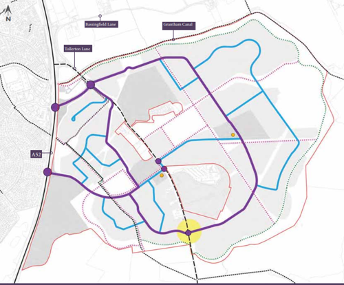
Key
- Allocation boundary - red line
- Junction node - purple circle
- Primary route - purple line
- Secondary route - blue line
- Walking trail - broken green line
- Proposed footway / cycleway - broken purple line
- Bus gate - yellow circular zone
- Mobility hub - orange dot
4.2 Access and Movement
4.3 Strategic Cycle Ways
Strategic cycle ways will provide safe, attractive and convenient connections between development parcels and key destinations within and around the Site. These cycle ways will be designed in accordance with LTN 1/20.
4.4 Footways and Cycle Ways
Pedestrian routes will promote people’s active movement and will link to existing recreational routes and destinations in and around the Site. Existing Public Rights of Way (PRoW) will be retained. Desire lines between key residential areas and destinations will underpin where routes are.
4.5 Public Transport Routes
4.6 Bus routes through the site will provide access to key destinations within and around the site, including local centres and education. Mandatory requirements:
- All primary streets (streets where vehicle volumes exceed 2,000 movements per day or where speeds are greater than 20mph) must be tree lined with a tree planted every 20m in a grass verge of a minimum width of 1.5m in accordance with the County Council’s Highway Design Guide (or any document(s) that supersede it);
- All primary streets (where vehicle volumes exceed 2,000 movements per day and where speeds are greater than 20mph) must have a 3m wide dedicated cycle way and 2m wide dedicated footway (5m wide when combined, and minimum 6.5m when incorporating the verge) separating them from the vehicular carriageway in accordance with the County Council’s Highway Design Guide (or any document(s) that supersede it);
- There must be a minimum 3m wide shared cycle way and footpath along all leisure routes within the open space areas;
- Paved in tarmac or equivalent smooth surfaces;
- Appropriate lighting in respect to route location, lighting will either be absent or be designed to limit light spill i.e. avoiding light pollution when crossing ecologically sensitive areas and adequate provision along key footways and cycle ways, such as from schools to residential areas. This will be determined by a Lighting Assessment;
- Safe crossing points must be provided at key junctions between roads and footways and cycle ways (as identified by, but not limited to, the purple dots labelled “junction nodes” on Figure 5 and must consider the requirement for priority to be given to non-motorised traffic in accordance with LTN 1/20 (or any document(s) that supersede it);
- Lit, secured, and covered bicycle and scooter parking facilities alongside seating and bins must be provided within local/neighbourhood centres, at community facilities, within open space areas and outside of schools; and
- Signage to be included to facilitate wayfinding and legibility.
- Secondary footways and cycle ways within the open space must be formed from a bound material, edged with solid edging kerbs that are consistent in terms of their materials, design, width and finish across all phases of the development (as a whole); and
- New tertiary, and any existing, footways and cycle ways through the site must be greater in width than 1.5m.
4.7 Primary Street
The primary street will form the main movement route into and around the Site for all transport modes, including buses. The street will provide a dedicated cycle way and pedestrian footways which will be separated from the carriageway by tree planting. Provision will be made for bus stops along the route of the street and the street will be designed to accommodate bus routes, in accordance to specifications defined within Manual for Streets. Junctions will be designed in such a way that priority will be given to cyclists and pedestrians, not cars. To enclose the space around this primary route at human scale buildings will predominantly be 2 storeys, with the exception of some 2.5- 3 storeys in key locations, with private drives set back from the pavement edge.
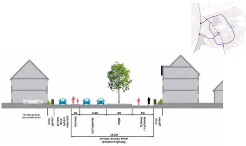
Mandatory requirements
- Tree lined street with grass verge and planting;
- Vehicular carriageway widths shall not exceed 6.2m to encourage slower speeds and facilitate safe crossings;
- Where demonstrated through Swept Path Analysis (and any other necessary evidence) vehicular carriageway widths of no more than 6.8m will only be considered with appropriate justification and should be the exception, not the norm;
- Vehicular carriageway widths outside of schools, shops and other demonstrated areas of increased activity will not exceed 6.5m;
- In accordance with the NCC Highway Design Guide, the carriageway width of 6.5m will be encouraged where it passes schools, shops and other areas of increased activity.
- Continuous cycle route with minimised access to driveways to avoid crossovers;
- Buildings setback distance must be consistent along road and plot frontages;
- Vehicular access must be provided so that crossovers are avoided to allow for a continuous cycle route Figure 6: Indicative Primary Street Section
5.0 Land Use and Built Form
5.1 Introduction
The Land Use and Built Form Strategy for the Site aims to create a vibrant neighbourhood, where different uses are conveniently located and at walking and cycling distance from most homes.
Role of the Site Wide Design Code is to inform the location and overarching coding principles for the different uses, the detailed design of which will be further informed within the relevant Character Area Code.
The Indicative Land Use and Building Heights Plan will define coding principles for:
- Residential areas;
- Mixed use areas;
- Local centre; and
- Education (primary and secondary schools).
Building Heights
There will be a wide variety of building heights set out across the Site ranging from 2 storeys to 4 storeys in key locations.
Density
A range of densities will feature across the site. These will respond to the proposed locations of key facilities and will relate to the site-wide movement strategy. Primary streets will have a higher density than the outer edges of the Site. This principle will also ensure a sensitive response to the site’s surrounding landscape.
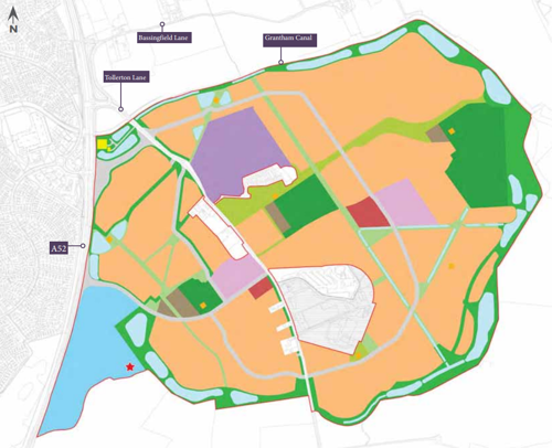
Key
- Allocation boundary - red line
- Residential - orange zones
- Secondary schools - purple
- Primary schools - lilac
- Employment - blue zone
- Local Centre - red zones
- Infrastructure - light grey
- Allotments - dark grey
- Formal sports and MUGA - dark green
- Neighbourhood parks - sage green
- Amenity space - light green
- Children's play - orange blocks
- Proposed surface water attenuation - light blue zones
- Proposed location for gypsy and traveller pitches if required
- Proposed sub-station - yellow block
5.2 Residential Areas
This section sets out the design coding principles, illustrated in Figure 9 , relating to the overall layout, and built form across the Site. The development will have a distinct urban form and structure strongly influenced by the site’s existing features and best design practice.
- Gateway Creation - To provide a sense of arrival a new gateway will be created at the development entrance. The buildings enclosing this space are to display a distinct architectural style and will be up to 3 storey in height and ideally taller than the adjacent buildings to create a focal point entrance.
- Key Spaces - A sequence of spaces along the main route and throughout the development will provide a variation in character and development treatment, aiding legibility for pedestrians and cyclists and offering traffic calming.
- Key Buildings - Buildings will be used to emphasise site access, key spaces, and the hierarchy of routes throughout the Site, aiding legibility. They can be achieved through scale, massing, use, architectural style and/or detailing. They will need to fulfil at least one of the following functions:
- terminating and/or completing vistas and key views;
- creating a gateway and pinch points;
- creating landmark buildings to support wayfinding; and / or
- creating a sense of scale at key spaces.
- Development Set Back and Front Boundaries - Development setbacks and front boundary treatment will follow the street coding principles set out in Section 4.2.
- Building Formality - Building formality across the site will vary depending on the character area it is within, for example Woodland View and Gamston Fields will feature more formal street frontage and formal response to green space than that of Gamston Meadows.
- Block Structure - Perimeter blocks will be the most common typology across the Site, with blocks located along the Primary Street generally access from the back or via small parking courts.
Mandatory requirements:
- All apartment and mixed-use blocks must have a clear distinction between public and private space (both internally and externally);
- All dwellings must have front doors and windows to habitable rooms addressing active frontages to provide natural surveillance to the public realm;
- The location, form and design of parking must be a key consideration in the character of the public realm;
- A selection of quality surface materials, street trees and furniture is essential in creating pleasant environment for residents and visitor;
- A mixture of on-plot and on-street parking solutions that benefit from natural surveillance from habitable rooms within dwellings must be designed as an integrated part of the design response;
- Quality surfacing materials, street trees street furniture and landscaping must be pro within residential areas to create a pleasant environment for residents and visitor;
- On-street parking must be limited to a maximum of 6 perpendicular or 4 parallel spaces without interruption;
- Courtyard parking must accommodate no more than 6 car parking spaces and must be overlooked by habitable rooms in the properties that the parking serves and must incorporate green infrastructure in the form of trees, planting areas and green space(s);
- Apartments and mixed-use blocks parking areas must be overlooked by occupied are within the properties they serve and must incorporate green infrastructure in the for trees, planting areas and green space;
- Minimum privacy distances of 21 metres must be maintained between the rear elevations of properties backing onto one another to achieve acceptable privacy levels for properties;
- Minimum privacy distances of 12 metres must be maintained between the rear elevations and side elevations of any neighbouring properties to achieve acceptable privacy levels for properties;
- Buildings should face the public realm with front doors and/or windows to habitable rooms to provide natural surveillance to streets;
- Space for the storage of minimum of 3x 180 litre wheeled bins (for refuse and recycling) to the rear of each dwelling, as well as accessibility to them, must be provided for each dwelling. Where bins are to be stored to the rear of the property, gated access must be provided to rear gardens;
- On private drives and unadopted highways, bin collection points must be provided ensuring that the distance householders are required to carry refuse does not exceed 30 metres. Surfaces that bins need to be moved over must be of a smooth continuous finish and free from steps or other obstacles, this includes traffic calming measures;
- For apartments and multi-use blocks the provision of storage areas for the appropriate number of bins to serve that block must be provided. The number of 1,100 litre bins needed is based on the number of properties, multiplied by 240, divided by 1,100 i.e. 15 x 240 = 3600/1,100 = 3.2 containers. The Council will round up where appropriate;
- Storage areas for 1,100 litre bins must allow a clear space of at least 150mm between and around each waste container and must be a minimum of 2 metres high. The storage area must also be permanently ventilated and should have a paved impervious floor;
- Each property must have space for secure, enclosed, storage for at least one cycle for apartments and secure, enclosed, storage for at least two cycles for houses. Cycle parking provision must, in all instances, be secure, easily accessible, and convenient to use;
- Each dwelling house with a rear/side gate in their garden, shall have the rear/side garden gate(s) fitted with two-way locks to enable them to be opened and locked from either side;
- All streets must be designed to give priority to the disabled, pedestrians, and cyclists. All surfacing materials must be agreed with the Local Planning Authority in advance of their usage;
- All streets must incorporate street lighting, level footways across driveway access points, and the alignment of pedestrian crossovers located across side street junctions must maintain the trajectory of the footpath (i.e. the desire line);
- Corner elevations must have windows serving habitable rooms and avoid long sections of blank walls (either in the property or gardens);
- The front entrance must face onto an active street and there must be no blank elevations (i.e. they cannot be devoid of any openings serving habitable rooms) onto the public realm; and
- All buildings that front onto primary streets (streets where vehicle volumes exceed 2,000 movements per day or where speeds are greater than 20mph) and all public/community buildings shall be built/erected using sustainable construction methods and from natural materials i.e. no concrete roof tiles, or artificial slates shall be used.
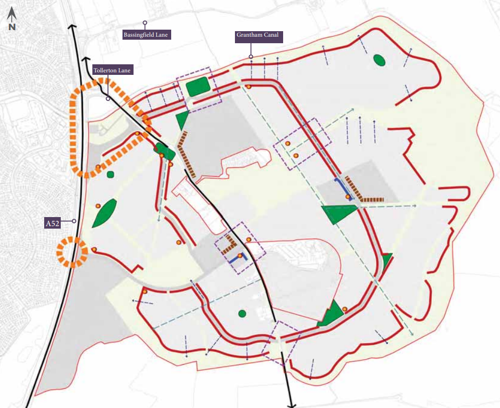
Key
- Allocation boundary - thin red line
- Existing road - black lines with arrowheads
- Key frontage - thick red line
- Key frontage (mixed use) - thick blue line
- Landmark (height) - orange dot with red outer circle
- Key views (indicative) - blue dashed line
- Long distance view - light green dashed line
- Gateway - orange blocks
- Key spaces - green zones
- Areas of design interest - purple dashed line rectangles
- Indicative school frontage - blown blocks
Note - residential includes ancillary infrastructure, secondary and tertiary streets and open space.
5.3 Mixed Use Areas
Non-residential uses will be co-located to maximise opportunities for social interaction and increase footfall, creating a vibrant hub for the new community and enhancing sense of place. The mixed use areas will have direct access to the strategic cycle ways and pedestrian links, and will be connected to the overall open space network.
5.4 Local Centre
The site makes provision for a mixed-use local centre located at the heart of the development, as seen in Figure 10. The local centre will provide a vibrant focus with a mix of retail, community, and residential uses. The design and uses provided within the local centre will be subject to a Reserved Matters Planning Application.
Visual dominance of parking within the public realm is to be limited by design;
- Including trees and planting to filter views;
- Locating large parking areas at convenient locations but away from key public spaces; and/or
- Maximise opportunities to share parking with different uses to reduce overall requirement.
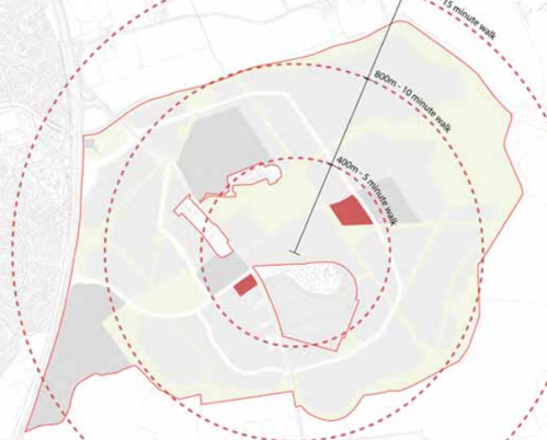
Key
- Allocation boundary - red line
- Walk zones 5, 10 and 15 minutes - broken red line
5.5 Primary and Secondary Education
The site provides land for new primary schools and a secondary school which will create new learning centres of excellence.
5.6 Primary Schools
The primary schools are an important placemaking element defining the identity of the new community, reflected in their location and built form appearance.
5.7 Secondary School
The development is likely to require the provision of a circa 640 secondary places using the 16/100dw yield adopted by Nottinghamshire County Council. The secondary school will require the following:
- Core facilities;
- Classrooms;
- Sports hall;
- Drop off / pick up point;
- Staff car parking;
- Sports pitches; and
- MUGA (Multi-Use Games Area).
The secondary school access, shown in Figure 11, will be located on the east side of Tollerton Lane to the north of the existing Tollerton Park caravan park and within close walking distance of all new residents. The secondary school is also located close to the main primary movement corridors and accessible by public transport. It is linked to a series of pedestrian and cycle routes which are well connected to open space and residential neighbourhoods. A grounds maintenance access has also been included to the east of the school site to more easily access the playing pitches.
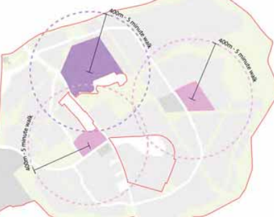
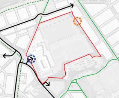
Key
- School site boundary - red line
- Footpath - green line
- Road - black line
- Fitness trail - broken black line
- School access - blue blocks in a circle
- Maintenance access - orange blocks in a circle
6.0 Area Design Instructions
6.1 Key Character
Areas and Distinctive Edge Frontage A strong character within a development is an important placemaking principle as it helps residents feel a sense of belonging, identity and pride in where they live. This can be achieved though layout, massing, landscaping and building appearance, all which add further layer of richness to the place.
Three character areas have been identified for consideration in the more detailed design stage. These respond to the wider influences of the Site which include land form, topography, landscape framework, and the relationship to the existing urban edge of Nottingham. Edge frontages have also been identified to ensure that the built form provides a suitable transition to the wider landscape and responds positively to the heritage sensitivities of the Grade II listed pillboxes and the airfield.
Names used in this document to identify character areas and other new places to be created are illustrative and may change in the future, subject to branding exercises in liaison with the local community. The design components of suggested character areas are described and illustrated in the following pages. The appropriate design responses will be reviewed, developed and refined in subsequent design stages.
The character areas comprise:
Woodland View - this neighbourhood includes the western and southern parts of the Site. These areas are enclosed by existing and proposed woodlands, with two distinctive edges of Primary Street Corridor and Wooded Edge.
Gamston Fields - the central and internal part of the development within proximity of schools and part of the main Primary Street length. With two distinctive edges of Primary Street Corridor and Canal Side.
Gamston Meadows - areas located to the east, within proximity of water attenuation features within a landscape setting. With a distinctive edge of the Water Meadows.
The following pages provide a better understanding of the character areas to inform future stages of the planning application. Detailed design instructions in this Site Wide Design Code have been created to ensure a distinctive, high quality design development that responds to and integrates with its context. For each area, a set of design coding instructions have been produced to guide future proposals.
Primary Street Frontage
The primary street, seen in Figure 12, spans both the Woodland View and Gamston Fields character areas. As such, the scale and massing of built form will vary accordingly and will be generally formal with the use of symmetry and vertical elements to emphasise height. Modern and traditional interpretations of the principles are appropriate.
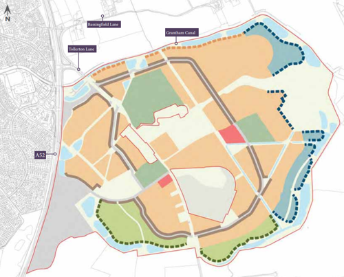
Key
- Allocation boundary - red line
- Meadows Area - blue-green zones
- Fields Area - orange zones
- Woodland View - light green area
- Local Centre - pink zones
- School - sage green zones
- Employment - grey zone adjacent to A52
- Spine corridor frontage - broad grey band
- Edge Frontage: Canal Side - orange dashed line
- Edge Frontage: Water Meadows - blue dashed line
- Edge Frontage: Woodland Edge - green dashed line
6.2 Woodland View
Overview
A residential neighbourhood heavily influenced by the creation of a new woodland edge. Building styles to be inspired by the local vernacular.
Character

This neighbourhood will have a more suburban feel with a semi-formal character inspired by the Garden City design principles found in parts of Edwalton. It will have a verdant character with trees within verges and/or front gardens where appropriate, and hedgerows and climbing plants on façades. Houses are to be set out around pockets of soft landscaped areas where appropriate.
Density
Density will range from 15 dwellings per hectare up to 45 dwellings per hectare (low to high).
Distinct Frontages
This area has two distinct frontages, the Woodland Edge and Primary Street, which are described opposite.
Built Form
Street scenes will have a variation of roof lines and ridge heights with mainly 2 and some 3 storeys and a mix of small terraces, semidetached and detached dwellings.
Landscape
The wooded landscape character to the south, beyond the Site, will give the edge here a strong character whilst formal spaces throughout the development parcels will allow for opportunities for play and green infrastructure benefits.
Woodland View Coding Summary
Layout
- Architectural Style: Mainly a traditional approach to architectural style and detailing inspired by the Arts and Crafts movement.
- Block Structure: Predominantly back-to-back blocks along the Primary Street to accommodate parking.
- Setback: Generally consistent within same building grouping.
- Front Boundary: Trimmed hedgerows as a common feature.
- Frontage / Corners: A more fragmented frontage with irregular spacing between buildings.
- Parking: On parking plot, visitor parking allowed along the street, with the exception of the primary street corridor.
Building Form
- Building Types: Small terraces, semis and detached.
- Building Height: A variation of 2 and 2.5 storeys, with 3 storeys in key locations. Building heights to have a larger proportion of 2 and 2.5 storey units.
Details and materials
- Roof: Varied roof profile.
- Dormers: Could be an occasional feature.
- Openings: Windows and doors can have a vertical or horizontal emphasis. Bay windows can be a unifying feature.
- Chimneys: Chimes or ventilation stacks to be more prominent in this location.
- Walls: Wall materials to have more variation. Red / orange brick and white render to be the most common materials.
Woodland Edge Frontage Treatments
Further to the overall characteristics of the Primary Street Corridor which are common to the entire neighbourhood (and set out in section 4.1 and 6.1) additional design instructions for Wooded Heights Frontage and the Primary Streets Frontage within the character area are set out below.
Woodland Edge Frontage
The development edge to the south is where building frontage face open space and areas of woodland. Building frontage should respond to its edge context. This frontage will have a degree of formality with architecture influences of the arts and craft movement. Red/orange brick, and white render to be the primary walling materials. Detached and semi-detached units are the dominant typologies within this area. The images and diagram below provide an indication of suitable design response to this edge.
Primary Street Frontage
A number of incidental spaces should feature along the Primary Streets that are within the Character Area; here frontage should provide enclosure to these spaces. The use of symmetry along to the frontage should be a common feature. Building frontage to be mostly continuous (less so than along Gamston Fields) with regular gaps between buildings and consistent building line/setbacks. A variation of 2 and 2.5 storeys, with 3 storey in key locations.
6.3 Gamston Fields
Overview
A residential neighbourhood with regular development blocks distributed to allow for long view corridors. Contemporary design and a formal streetscape will be promoted.
Character
This area will be predominantly formal with orthogonal shaped blocks set in a framework grid of mostly north-south and east-west streets. This area will favour a more contemporary approach to architecture, however, traditional designs are also appropriate providing they deliver high quality and modern technologies.
Density
Density will range from 35 dwellings per hectare up to 45 dwellings per hectare (medium to high).
Distinct Canalside and Primary Route Frontages
This area has two distinct frontages which are described opposite. The Canal Side Frontage will feature along the most northern extents of development and will create a positive interface with Grantham Canal.
Built Form
Buildings are predominantly terraced and semi-detached with occasional detached units. Building heights will vary from 2, 2.5 and 3 storeys.
Landscape
Landscape within Gamston Fields will typically be formal and structured where development area meets open space, leaving the more naturalistic landscape to the outer edges of the Site.
The table adjacent details further design coding for the character of Gamston Fields.
Gamston Fields Coding Summary
Layout
- Architectural Style: Both contemporary or traditional architecture interpretations are appropriate. Linear development along the Canalside and more formal frontage on the Primary Street Corridor.
- Block Structure: Predominantly perimeter blocks with on-street parking and on-plot. Occasional courtyard blocks are also appropriate.
- Setback: Subtle variation of setback, but regular.
- Front Boundary: Consistent boundary treatment on both sides of the street. Railings and low walls for the Primary Street and Canal frontages. Informal planting and hedges also possible in other areas.
- Frontage and corners: Continuous frontage, parallel to the street with regular intervals between properties. Active windows and doors on both facades. For internal parcels, frontage can be more fragmented.
- Parking: On plot parking, visitor parking allowed along the street, with the exception of the Primary Street Corridor.
Building Form
- Building Types: Predominantly terraced and semi-detached properties.
- Building Height: A variation of 2 and 2.5 storeys, with 3 storeys in key locations.
Details and materials
- Roof: Variation in roof heights along central areas to reflect high street typologies.Elsewhere minimum variation on roof profiles.
- Dormers: Can be a feature. To be used at key locations to increase building height vertically.
- Openings: Windows and doors to have a vertical emphasis.
- Chimneys: Chimneys and ventilation stacks to be of simple style as part of the building fabric to emphasise verticality.
- Walls: Wall materials to be predominantly red brick. A limited palette of materials which responds to the local character assessment, will emphasis the formality of this area.
Gamston Fields Edge Frontage Treatments
Further to the overall characteristics of Primary Street Corridor which are common to the entire neighbourhood (and set out in section 4.1 and 6.1) additional design instructions for the Primary Street Corridor and Canal Side Frontage are set out below.
Canal Side Frontage
Canal Side will have a special edge frontage onto Grantham Canal. Buildings will maximise canal views and be influenced by ‘Wharf’ architectural style predominantly in orange/red brick and with timber detailing. A modern interpretation of the ‘wharf’ typology is encouraged where possible and large glazed windows could feature on the front elevation. Red/orange brick, indigenous to the area and white render and horizontal timber boarding should constitute the primary elevation materials.
Primary Street Frontage
The Primary Street moves through both Gamston Fields and Gamston Gardens character areas and, as such, the scale and massing of the built form will vary accordingly. The Primary Street character will be generally formal with the use of symmetry and vertical elements to emphasise height. Continuous frontage with regular gaps between buildings and consistent building line/ setbacks. Dwellings are to be accessed via Streets from the back, via side streets or via access lanes located in front of the dwellings. Building height should be emphasised to respond to the road wide corridor. Building heights should also reflect the character area which the Primary Street is within. Both modern and tradition interpretations of the principles are appropriate.
6.4 Gamston Meadows
Overview
A residential neighbourhood with an organic and informal development form heavily influenced by its natural landscape context.
Character
This area will have an informal character with variation in building line which will help the residential development here feel more organic. Verdant character with trees within plots, hedgerows and climbing plants on façades.
Density
Density will range from 15 dwellings per hectare up to 30 dwellings per hectare (low to medium).
Distinct Frontages
Water Meadows is a distinct frontage within this area. Frontages will respond to its edge context and will have a strong landscape feel.
Built Form
Buildings are predominantly 2 - 2.5 storeys, with some range of roof lines and subtle variation on ridge heights. For single sided minor routes, streets will generally adopt a more organic pattern.
Landscape
This area will tie in with the Grantham Canal landscape treatment and extend around the majority of the Site’s eastern edges. It is a landscape led neighbourhood which generally fronts open space.
Gamston Meadows Coding Summary
Layout
- Architectural Style: Both contemporary or traditional architecture interpretations are appropriate.
- Block Structure: Predominantly perimeter blocks with on-street parking and on-plot. Occasional courtyard blocks are also appropriate. An organic block structure with variable building line and building orientation.
- Setback: Subtle variation of setback.
- Front Boundary: Consistent boundary treatment on both sides of the street. Estate railings, low walls or hedges; all of which will give variation and informality to the area.
- Frontage / Corners: Continuous frontage, parallel to the street with regular intervals between properties. Active windows and doors on both facades.
- Parking: On plot parking, visitor parking allowed on the street.
Building Form
- Building Types: Larger proportion of semi-detached and detached properties with front gardens.
- Building Height: 2 and 2.5 storeys.
Details and materials
- Roof: Variation on roof heights to reflect informal character.
- Dormers: Can be a feature.
- Openings: Windows and doors to have a horizontal emphasis and a varied range of frame colours.
- Chimneys: Chimneys to be a common feature.
- Walls: Wall materials to have more variety than the Gamston Fields area, it should include brick, timber and light render colours.
Gamston Meadows Edge
Frontage Additional design instructions for the Water Meadows special frontage are illustrated on the following pages and will be further developed in the later stages of the planning application.
Water Meadows Frontage
Continuous frontage with regular gaps between buildings and stepped building line/setbacks. Dwellings are to be accessed via tertiary streets and lanes / shared drives will be the main street coding in the Meadows character area. A more varied roof line between 1.5 to 2.5 storey. Both modern and tradition interpretations of the principles are appropriate.
7.0 Design and Planning Matters Coverage Checklist
7.1 Introduction
The checklist on the following page identifies at which point in the planning process for the Site key design and other planning considerations will be addressed.
The submission to and agreement by the Council of Area Design Codes will usually follow after the outline application stage and ahead of applications for detailed planning consent; with Area Design Codes being required as a condition of outline planning consents. However, in those cases where detailed matters (appearance, means of access, landscaping, layout or scale) are not reserved at the outline planning application stage, then an Area Design Code would need to be submitted as part of the planning application. This would also apply to any full or hybrid planning applications where a relevant Area Design Code is not already in place.
Area Design Codes will be required for every part of the Site, unless an exception is justified. It is expected that they will generally correspond to those areas with outline planning permission, although, in certain cases, a separate Area Design Code for a smaller sub-area will be appropriate; for example, for a Local Centre area. In some cases, an Area Design Code may be needed for an area that straddles two or more outline planning permission areas. It is anticipated that this may be the case for the Sports Hub areas.
Context
| Site Key Design or Planning Consideration | Development Framework SPD | Site Wide Design Code | Outline Applications | Area Design Codes | Reserved Matters or Full Applications |
|---|---|---|---|---|---|
| Character Types | Yes | - | - | Yes | - |
| Site Context | Yes | - | Yes | - | - |
| Site Assessment | Yes | - | - | - | - |
| Historic Assessment | Yes | - | Yes | Yes | Yes |
| Heritage Assets | Yes | - | Yes | - | Yes |
Movement
| Site Key Design or Planning Consideration | Development Framework SPD | Site Wide Design Code | Outline Applications | Area Design Codes | Reserved Matters or Full Applications |
|---|---|---|---|---|---|
| Street Network | Yes | Yes | Yes | Yes | Yes |
| Public Transport | Yes | Yes | Yes | Yes | Yes |
| Street Hierarchy | Yes | Yes | Yes | Yes | Yes |
| Walking and Cycling | Yes | Yes | Yes | Yes | Yes |
| Junction and Crossings | Yes | Yes | - | Yes | Yes |
| Inclusive Streets | Yes | Yes | - | Yes | Yes |
| Car Parking and Cycle Parking | - | Yes | Yes | Yes | Yes |
| Services and Utilities | Yes | Yes | Yes | Yes | Yes |
Nature
| Site Key Design or Planning Consideration | Development Framework SPD | Site Wide Design Code | Outline Applications | Area Design Codes | Reserved Matters or Full Applications |
|---|---|---|---|---|---|
| Network Spaces | Yes | Yes | - | Yes | Yes |
| Design | - | Yes | Yes | Yes | Yes |
| Working with Water | Yes | Yes | - | Yes | Yes |
| SUDS | Yes | Yes | Yes | Yes | Yes |
| Flood Risk | Yes | - | Yes | - | Yes |
| Net Gain | Yes | - | - | - | Yes |
| Biodiversity | Yes | Yes | Yes | Yes | Yes |
| Street Trees | - | - | - | Yes | Yes |
Built Form
| Site Key Design or Planning Consideration | Development Framework SPD | Site Wide Design Code | Outline Applications | Area Design Codes | Reserved Matters or Full Applications |
|---|---|---|---|---|---|
| Density | Yes | Yes | Yes | Yes | Yes |
| Party Wall | - | - | - | - | Yes |
| Types and Forms | Yes | Yes | - | Yes | Yes |
| Blocks | - | Yes | Yes | Yes | Yes |
| Building Line | - | Yes | - | Yes | Yes |
| Height | Yes | Yes | Yes | Yes | Yes |
Identity
| Site Key Design or Planning Consideration | Development Framework SPD | Site Wide Design Code | Outline Applications | Area Design Codes | Reserved Matters or Full Applications |
|---|---|---|---|---|---|
| Local Character | Yes | Yes | Yes | Yes | - |
| Legibility | - | Yes | Yes | Yes | Yes |
| Masterplanning | Yes | Yes | Yes | Yes | - |
| Design of Buildings | - | - | - | Yes | Yes |
Public Space
| Site Key Design or Planning Consideration | Development Framework SPD | Site Wide Design Code | Outline Applications | Area Design Codes | Reserved Matters or Full Applications |
|---|---|---|---|---|---|
| Primary | - | Yes | - | Yes | Yes |
| Local and Secondary | - | Yes | - | Yes | Yes |
| Tertiary | - | - | - | Yes | Yes |
| Meeting Places | - | Yes | - | Yes | Yes |
| Multi-functional | - | Yes | - | Yes | Yes |
| Home Zones | - | - | Yes | Yes | Yes |
| Secured by Design | - | - | - | Yes | Yes |
Uses
| Site Key Design or Planning Consideration | Development Framework SPD | Site Wide Design Code | Outline Applications | Area Design Codes | Reserved Matters or Full Applications |
|---|---|---|---|---|---|
| Efficient Land Use | Yes | - | Yes | Yes | Yes |
| Mix, Housing for All and Type | Yes | - | Yes | Yes | Yes |
| Active Frontage | - | Yes | Yes | Yes | Yes |
| Schools | Yes | Yes | Yes | Yes | Yes |
| Community Facilities | Yes | Yes | Yes | Yes | Yes |
| Local Services | Yes | Yes | Yes | Yes | Yes |
Homes and Buildings
| Site Key Design or Planning Consideration | Development Framework SPD | Site Wide Design Code | Outline Applications | Area Design Codes | Reserved Matters or Full Applications |
|---|---|---|---|---|---|
| Space Standards | - | - | - | - | Yes |
| Accessibility | - | - | - | - | Yes |
| Light, Aspect, Privacy and Security | - | - | - | Yes | Yes |
| Gardens and Balconies | - | - | - | Yes | Yes |
Resource
| Site Key Design or Planning Consideration | Development Framework SPD | Site Wide Design Code | Outline Applications | Area Design Codes | Reserved Matters or Full Applications |
|---|---|---|---|---|---|
| Energy Hierarchy | Yes | - | - | - | Yes |
| Energy Efficiency | Yes | - | - | - | Yes |
| Neighbourhood Energy and Embodied Energy | - | - | - | - | Yes |
| Construction / Modern Methods of Construction | - | - | - | - | Yes |
| Water | Yes | - | - | - | Yes |
Lifespan
| Site Key Design or Planning Consideration | Development Framework SPD | Site Wide Design Code | Outline Applications | Area Design Codes | Reserved Matters or Full Applications |
|---|---|---|---|---|---|
| Management Plan | Yes | - | Yes | - | Yes |
| Participation / Community | Yes | - | Yes | - | Yes |