Air Quality Annual Status Report 2025
2025 Air Quality Annual Status Report (ASR)
In fulfilment of Part IV of the Environment Act 1995 Local Air Quality Management, as amended by the Environment Act 2021
Information: Rushcliffe Borough Council Details
Local Authority Officer: Caroline McCaffrey
Department: Environmental Health
Address: Rushcliffe Borough Council, Rushcliffe Arena, Rugby Road, West Bridgford, Nottingham, NG2 7YG
Telephone: 0115 981 9911
Email: environmentalhealth@rushcliffe.gov.uk
Report Reference Number: ASR 2025
Date: 30 June 2025
Table of Contents
The Air Quality Annual Status Report 2025 is also available in pdf.
Local Responsibilities and Commitment
Executive Summary: Air Quality in Our Area
1 Local Air Quality Management
2 Actions to Improve Air Quality
- 2.1 Air Quality Management Areas
- 2.2 Progress and Impact of Measures to address Air Quality in Rushcliffe Borough Council
- 2.3 PM2.5 – Local Authority Approach to Reducing Emissions and/or Concentrations
3 Air Quality Monitoring Data and Comparison with Air Quality Objectives and National Compliance
- 3.1 Summary of Monitoring Undertaken
- 3.1.1 Automatic Monitoring Sites
- 3.1.2 Non-Automatic Monitoring Sites
- 3.2 Individual Pollutants
- 3.2.1 Nitrogen Dioxide (NO2)
- 3.2.2 Particulate Matter (PM10)
- 3.2.3 Particulate Matter (PM2.5)
Appendix A: Monitoring Results
Appendix B: Full Monthly Diffusion Tube Results 2023
Appendix C: Supporting Technical Information / Air Quality Monitoring Data QA/QC
New or Changed Sources Identified Within Rushcliffe Borough Council During 2024
Additional Air Quality Works Undertaken by Rushcliffe Borough Council During 2024
QA/QC of Diffusion Tube Monitoring
Diffusion Tube Bias Adjustment Factors
Nitrogen Dioxide Fall-off with distance from the road
Automatic Monitoring Annualisation
Nitrogen Dioxide Fall-off with distance from the road
Appendix D: Maps of Monitoring Locations and AQMAs
Appendix E: Summary of Air Quality Objectives in England
Appendix F Supporting Information for Revocation of AQMAs
Local Responsibilities and Commitment
This ASR was prepared by the Environmental Health Department of Rushcliffe Borough Council (RBC) with the support and agreement of the following officers and departments:
- RBC Development Control;
- RBC Planning Policy;
- RBC Communities;
- RBC Economic Growth;
- RBC Human Resources; and
- Ellie Jaycock and Sean Parks - Transport Planning and Programme Development Place Department, Nottinghamshire County Council;
- Jo Marshall - Public Health and Commissioning Manager, Public Health Adult Social Care and Health, Nottinghamshire County Council.
This ASR has been approved by:
David Banks
Director - Neighbourhoods and Deputy Chief Executive
This ASR has been signed off on behalf of the Nottinghamshire County Councils Director of Public Health and Communities by:
Jo Marshall - Public Health and Commissioning Manager.
If you have any comments on this ASR please send them to the Environmental Health Department at:
Rushcliffe Borough Council
Rushcliffe Arena
Rugby Road
West Bridgford
NG2 7YG
Tel: 0115 9819911
E: environmentalhealth@rushcliffe.gov.uk
Executive Summary: Air Quality in Our Area
Air Quality in Rushcliffe Borough Council
Breathing in polluted air affects our health and costs the NHS and our society billions of pounds each year. Air pollution is recognised as a contributing factor in the onset of heart disease and cancer and can cause a range of health impacts, including effects on lung function, exacerbation of asthma, increases in hospital admissions and mortality.
Air pollution particularly affects the most vulnerable in society, children, the elderly, and those with existing heart and lung conditions. Low-income communities are also disproportionately impacted by poor air quality, exacerbating health and social inequalities.
A brief explanation of the key pollutants relevant to Local Air Quality Management and the kind of activities they might arise from.
- Nitrogen Dioxide (NO2) - Nitrogen dioxide is a gas which is generally emitted from high-temperature combustion processes such as road transport or energy generation.
- Sulphur Dioxide (SO2) - Sulphur dioxide is a corrosive gas which is predominantly produced from the combustion of coal or crude oil.
- Particulate Matter - (PM10 and PM2.5)
Particulate matter is everything in the air that is not a gas.
Particles can come from natural sources such as pollen, as well as human made sources such as smoke from fires, emissions from industry and dust from tyres and brakes.
PM10 refers to particles under 10 micrometres. Fine particulate matter or PM2.5 are particles under 2.5 micrometres.
Road traffic is the main source of air pollution within the Rushcliffe Borough and nitrogen dioxide is the primary pollutant of concern. Nitrogen dioxide is a brown gas with the chemical formula NO2. It is chemically related to nitric oxide (NO) and together NO and NO2 are known as NOx. NOx is released into the atmosphere when fuels are burned, for example petrol or diesel in a car engine, or natural gas in a domestic central heating boiler. Nitrogen dioxide can affect our health and evidence indicates high levels can inflame the airways of our lungs, and over the long term can affect how well our lungs work. The concentration of nitrogen dioxide is measured as micrograms per cubic metre of air (μg m-3) and to protect health the Government has set air quality standards. The hourly objective which is the concentration of nitrogen dioxide in the air averaged over a period of one hour, aims to ensure we are not exposed to high concentrations for short periods of time. The annual objective which is the concentration of nitrogen dioxide in the air averaged over a period of one year, aims to protect us over the longer term. Further details on the air quality standards can be found in Appendix E: Summary of Air Quality Objectives in England.
Road traffic is the largest source of NOx emissions in the UK. NOx emissions from burning fossil fuels are mainly as NO. However, some sources including diesel vehicles (particularly when moving slowly) can emit a lot of NOx as nitrogen dioxide and these primary emissions of nitrogen dioxide can lead to high concentrations at the roadside. Nitrogen dioxide is also formed in the atmosphere when there is a chemical reaction between NO and ozone, and this is known as secondary nitrogen dioxide.
Rushcliffe Borough Council currently undertakes air quality monitoring for nitrogen dioxide at 31 monitoring sites across the Borough. Twenty-nine of these locations are passive sites, monitoring nitrogen dioxide using diffusion tubes which take samples over a one-month period (approximately) and are useful for assessing the annual objective of 40μg cubic metres. Diffusion tubes provide an inexpensive way of monitoring air quality at multiple sites and provide general indicators of concentrations and trends of pollutants over a period of time.
Rushcliffe Borough Council also have two continuous analysers (automatic) where air is continuously pumped into the analyser and the level of nitrogen dioxide recorded. These provide more accurate data on nitrogen dioxide concentrations however they are a more expensive way of monitoring air quality.
Rushcliffe Borough Council has two active Air Quality Management Areas (AQMAs) for nitrogen dioxide. An AQMA is an area where air pollutant concentrations exceed or are likely to exceed the relevant air quality objectives. AQMAs are declared for specific pollutants and objectives and within Rushcliffe both were declared for nitrogen dioxide and exceedance of the annual mean concentration objective of 40μg cubic metres. The location of the AQMAs can be seen at Defra UK AIR website. Monitoring is undertaken in both AQMAs using both diffusion tubes (non-automatic or passive) and a continuous analyser (automatic).
Within AQMA No 1 Trent Bridge the highest nitrogen dioxide annual mean concentrations recorded in 2024 across all locations were 26.2 micro-grams per cubic metre of air at the diffusion tube location TBI and 24.5 micro-grams per cubic metre of air at the continuous monitor. Therefore, the nitrogen dioxide annual mean concentrations were all well below the air quality objective. There were also no exceedances of the nitrogen dioxide hourly limit of 200 micro-grams per cubic metre of air and therefore no exceedance of the 1-hour mean air quality objective. The data continue the downward trend in the nitrogen dioxide annual mean concentration evident over the past six years. In general, nitrogen dioxide annual mean concentrations recorded at the eleven existing locations across AQMA No 1 Trent Bridge were consistent with the 2023 and 2022 data. Of note the 2023 data for diffusion tube location TBLB had showed an increase in the nitrogen dioxide annual mean concentration to 29.9 micro-grams per cubic metre of air up from 20.6 micro-grams per cubic metre of air in 2022. The 2024 data shows a nitrogen dioxide annual mean concentration of 20.3μg cubic metres at this location, consistent with the 2022 data indicating the increase in 2023 is likely to have been associated with a temporary source. The consistency between the 2022, 2023 and 2024 data may indicate a stabilisation in traffic flow as the population lifestyle changes, such as hybrid working, precipitated by the COVID-19 pandemic have become more established. Less congestion at the junction of Radcliffe Road and Loughborough Road combined with increased electric vehicle update (private cars, taxis and buses) are likely the most significant contributors to the decrease in the nitrogen dioxide annual mean concentrations.
In AQMA No 1/2011 Stragglethorpe Road a maximum nitrogen dioxide annual mean concentration of 24.8μg cubic metres was recorded at diffusion tube location A52/HHF1. This is well below the air quality objective. In 2024 all four monitoring locations recorded consistent nitrogen dioxide annual mean concentrations ranging from a minimum of 22.2 micro-grams per cubic metre of air to a maximum of 24.8 micro-grams per cubic metre of air. The previous year’s data (2023) data had shown a significant decrease (from 35 micro-grams per cubic metre of air to 23.4 micro-grams per cubic metre of air) in the measured nitrogen dioxide annual mean concentrations recorded at the continuous monitor when compared with 2022 data. The 2024 shows this decrease has been sustained. There were no exceedances of the nitrogen dioxide hourly limit of 200 micro-grams per cubic metre of air and therefore no exceedance of the 1-hour mean air quality objective. National Highways completed improvements at the Stragglethorpe junction during 2023 as part of their A52 Nottingham Junctions Improvement Scheme. Following the removal of the U-turn movement the phasing of the traffic signals was synchronised with the nearby Gamston roundabout traffic signals to improve traffic flow and ease congestion. A combination of factors including the junction improvements, longer-term lifestyle changes such as hybrid working, and increased electric vehicle use are likely to have contributed to the sustained decrease in nitrogen dioxide concentrations.
In general, over the last five-year period monitoring data shows a decline in the nitrogen dioxide concentrations across the Borough. Across the monitoring network the nitrogen dioxide annual mean concentrations recorded in 2024 remain well below the air quality objective. In general, the 2024 data is consistent with that recorded in 2023 indicating lifestyle changes required to deal with the COVID-19 pandemic continue to have a longer-term impact on population behaviour e.g. hybrid working which reduces traffic congestion at peak times. In addition, Zap Map, which is a charging point platform designed to support the electric vehicle (EV) community continues to report growth in the number of battery electric car registrations. In 2024 there were 381,970 new fully electric cars sold, which was 19.6% market share of all new cars registered that year. More fully electric cars were sold in 2024 than any other year and represented 21% more than in 2023.
As monitoring data across the two AQMAs has shown a sustained decrease in nitrogen dioxide annual mean concentrations for the past five years work commenced towards the end of 2024 on the revocation of both AQMAs. Further detail is provided in Appendix C: Supporting Technical Information / Air Quality Monitoring Data QA/QC and Appendix F Supporting Information for Revocation of AQMAs.
During 2024, Rushcliffe Borough Council and its partners continued to implement the measures contained in our 2021 Air Quality Action Plan 2021-2026 (AQAP) to improve air quality in the two AQMAs and across the wider the Borough. Within the AQAP actions have been developed under nine broad topics:
- Traffic management;
- Transport planning and infrastructure;
- Policy guidance and development control;
- Alternatives to private vehicle use;
- Promoting low emission transport;
- Promoting travel alternatives;
- Public information; and
- Vehicle fleet efficiency.
The AQAP priorities are:
- To continue to monitor nitrogen dioxide levels at AQMA No1 Trent Bridge and at AQMA No1/2011 Stragglethorpe Road and to revoke the AQMAs (in consultation with Defra) if and when there is sufficient robust data to demonstrate concentrations are well below the air quality standard objectives4 for a period of four to five years;
- To work with Nottinghamshire County Council, as the highway authority at the location of AQMA No 1 Trent Bridge, to implement the relevant actions set out within the AQAP to manage traffic volume and flow and enable residents to make smarter travel choices;
- To work with National Highways, as the highway authority at the location of AQMA No 1/2011 Stragglethorpe Road to implement the relevant actions set out within the AQAP to manage traffic volume and flow; and
- Rushcliffe Borough Council will continue to work with partners to actively promote policies to encourage an increased use of low emission travel options in the Borough; and to secure funding for the installation of a publicly accessible vehicle charging network infrastructure across our estate.
The aim of these priorities is to maintain sustained compliance with the air quality standards, to encourage a shift to low emission transport options and smarter travel choices to facilitate and encourage walking, cycling and public transport use, all of which have co-benefits on health and well-being.
Actions to Improve Air Quality
Whilst air quality has improved significantly in recent decades, there are some areas where local action is needed to protect people and the environment from the effects of air pollution.
At a national level the Environmental Improvement Plan[Defra. Environmental Improvement Plan 2023, January 2023] sets out actions that will drive continued improvements to air quality and to meet the new national interim and long-term targets for fine particulate matter (PM2.5), the pollutant most harmful to human health. The Air Quality Strategy [Defra. Air Quality Strategy – Framework for Local Authority Delivery, August 2023] provides more information on local authorities' responsibilities to work towards these new targets and reduce fine particulate matter in their areas.
The Road to Zero [DfT. The Road to Zero: Next steps towards cleaner road transport and delivering our Industrial Strategy, July 2018] details the Government’s approach to reduce exhaust emissions from road transport through a number of mechanisms, in balance with the needs of the local community. This is extremely important given that cars are the most popular mode of personal travel and the majority of Air Quality Management Areas (AQMAs) are designated due to elevated concentrations heavily influenced by transport emissions.
As traffic is the main cause of the air pollution within the Borough the core actions continue to be the integration of measures within the Local Transport Plan (LTP) which is implemented by Nottinghamshire County Council Transport Planners and National Highways. Rushcliffe Borough Council will continue to work these partners to improve air quality across the Borough. This requirement for collaboration is further strengthened in the above referenced national Air Quality Strategy which sets out a framework to enable local authorities to deliver for their communities and contribute to the long-term air quality goals, including the new targets for fine particulate matter (PM2.5). In recognition of air quality as a public health issue the strategy requires the involvement of Directors of Public Health in local air quality action and better collaboration between lower and upper tier authorities. Where causes of, or contributors to, an AQMA fall within the control of another relevant body, those bodies should contribute measures to the AQAP and carry out those measures.
Within Rushcliffe Borough Council the Environmental Health Service continues to work with colleagues in the Planning Service to ensure air quality issues are considered as part of the policy and forward planning process, as well as during the development control process. Policy 41 of the Local Plan Part 2: Land and Planning Policies (adopted in October 2019) explicitly addresses air quality and development proposals that have the potential to adversely impact on air quality or are sensitive to poor air quality. Details of the Local Plan can be found on our RBC Local Plan webpage. Part 1 of the Local Plan (Core Plan) is currently being updated and it is anticipated a joint strategic plan prepared by Rushcliffe Borough Council, Nottingham City and Broxtowe Borough Council will be available in 2026. During the development process both construction and operational impacts are considered and where appropriate conditions imposed, or the application is amended to reflect any concerns identified.
During 2024, as in previous years there were a number of applications relating to proposed residential and commercial developments where air quality assessments were required and reviewed. Works are also progressing on previously permitted housing developments at various locations across the Borough, including Ruddington, Edwalton, Radcliffe on Trent and Clifton. In addition to considering potential air quality impacts as part of the development process the Environmental Health Service are involved in ensuring effective measures to manage any fugitive dust emissions are in place during the construction works.
A Local Development Order (LDO) was adopted in July 2023 for the development of the Ratcliffe on Soar Power Station which seeks to transform the wider Site into a centre for energy production and storage, advanced manufacturing and industry. The Site covers 265 hectares with part comprising the power station used for the generation of electrical power from coal and gas oil; and part comprising agricultural land, settlement ponds, wooded areas and the ash disposal site. Two hundred hectares have been designated as part of the East Midlands Freeport. The Power Station ceased operations in September 2024 and preparatory works for decommissioning have commenced.
Rushcliffe Borough Council has a requirement for electric vehicle charging points (EVCP) to be installed on all residential and commercial developments (where possible) as part of any planning approval.
The road network within AQMA No 1 Trent Bridge is managed by Nottinghamshire County Council and the core actions continue to be the integration of measures within the Local Transport Plan (LTP) which is implemented by Nottinghamshire County Council and include:
- Continued traffic control and management in the area to optimise traffic flow and minimise congestion;
- Cycling and walking infrastructure improvements;
- Public transport improvements, including the introduction of a low emission bus fleet; and
- Promotion of active travel alternatives.
The A52, the road associated with AQMA No 1/2011 Stragglethorpe Road is managed by National Highways. As part of their A52 Junction Improvement Scheme significant improvements were completed at the Stragglethorpe junction in 2023 which has improved traffic flow and eased congestion as evidenced by the monitoring data. Further improvements are planned for the Nottingham Knight (West Bridgford) and Wheatcroft (Edwalton) junctions to improve traffic flow, reduce congestion and provide capacity for local developments. Although the Department for Transport's (DfT) spending portfolio, including current and future road schemes, is currently under review work is continuing on the scheme.
At a strategic level the new Rushcliffe Borough Council Corporate Strategy (2024-2027) retains ‘The Environment’ as one of it's four priorities. In March 2020 the Council made a commitment to work towards being carbon neutral for its own operations by 2030. The Council continues to work to implement the Carbon Management Plan 2022 which sets out the measures to be taken across key areas, including property assets, fleet, and policy & regulation. The implementation of some of these proposed changes will have a co-benefit of improving air quality across the Borough e.g. measures to accelerate the shift to low carbon transport across the Council fleet, promotion of active travel and the promotion of carbon reduction policies and guidance to developers. Specific measures in 2024 include:
- Removal of large fossil fuel gas boilers at the Cotgrave Swimming Pool and replacing them with zero emission air source heat pump technologies;
- Vastly improving the efficiency of fuel poor properties across the Borough resulting in them having to use less fossil fuel gas heating and/or entirely taken off oil or LPG in off gas areas;
- Following a successful pilot scheme all of the Rushcliffe Borough Council heavy bin lorry fleet is now fuelled on HVO (Hydrogenated Vegetable Oil). In addition to 90% carbon dioxide (CO2) reduction the move away from diesel engines will reduce nitrogen dioxide emissions; and
- Purchase of all electricity for Council facilities from a REGO (Renewable Energy Guarantee of Origin) tariff.
Rushcliffe Borough Council seeks to reduce impacts on air quality and the environment in their ongoing capital projects. In recently completed capital projects active design and construction choices were taken to reduce impacts on air quality including:
- Rushcliffe Oaks, our Council operated crematorium facility where an electric cremator produces 50-80% less CO2 emissions and 33% less NOx emissions [Copeland B (2021) A comparison of gas and electric cremator emissions in the UK. A dissertation submitted to the School of Energy, Construction and Environment, Faculty of Engineering, Environment and Computing, Coventry University in partial fulfilment of the requirements for the degree of Geography BSc (Hons)], and
- The Bingham Arena and Enterprise Centre, a £16m leisure centre and office development project partly funded by the European Regional Development Fund (ERDF) and D2N2 Local Enterprise Partnership opened in 2023. The build is 80% lower carbon than standard new build leisure centres /offices due to the installation of a range of design parameters and equipment choices which will have a co-benefit of reducing the impact on air quality. These include combined heat and power units in the leisure centre, air source heat pumps and photovoltaic solar panels on the office roof.
Current projects include:
- Decarbonisation of the Cotgrave Leisure Centre by removing the old gas boilers and replacing them with a state-of-the-art air source heat pumps and solar photovoltaics. In addition to improving energy efficiency and removing 300 tonnes of carbon emissions a year the replacement of the gas boilers will have air quality co-benefits by reducing NOx emissions;
- Decarbonisation works at Gamston Community Hall and the Sir Julien Cahn Pavillion using the same air source heat pump technology as Cotgrave. The Sir Julien Cahn Pavillion is also getting a major insulation fabric upgrade to bring it up to a modern insulation standard; and
- The Warm Homes Local Grant scheme goes live where the Council will be looking to address energy efficiency/renewable energy solutions for people in fuel poverty. The 3-year scheme starts in Summer 2025 at a total value of approximately £1.3 million. Around 90 homes are expected to benefit from the scheme during 2025.
To encourage an increased use of low emission travel options Rushcliffe Borough Council continue to explore funding opportunities to increase EV charging point coverage across the Council estate and work with others to try to overcome capacity issues and smarten the grid to facilitate charging point installation. This lack of capacity has been a constraint in expanding the charging network across West Bridgford, our biggest population centre. As a result of collaborative work with partners, including Western Power over the past few years we are now seeking to install 16 to 20 rapid to medium EV charge points at Bridgford Road Carpark and Gardeners Road (M&S) Carpark.
Throughout 2024 Rushcliffe Borough Council continued to promote its Walking and Cycling Action Plan (published in 2022) which aims to increase participation in walking and cycling by all in Rushcliffe. A series of cycling and walking events were held at locations across the Borough, including:
- Walking and Cycling Event at Rushcliffe Country Park (August 2024) – this saw taster sessions delivered by Ridewise showcasing their adapted bikes; smoothie bike; Cycle Jukebox; bike registering and marking from Community Safety and Dr Bike who offered a free bike maintenance service. Wellbeing Walks were promoted and an organised walk took place on the morning of the event. Nottinghamshire Orienteering Club also attended to promote the sport and the club’s activities. Approx 1,000 people attended during the 4 hour event;
- Workplace Health – twice yearly walks arranged for staff;
- Friendship Calendar includes local health walks taking place in North, South and Central Rushcliffe, and incorporated in the Rushcliffe Seasonal wellbeing Challenges;
- Big Green Book – promotion of nature-based activities and interventions across the borough, also highlights green and blue spaces, parks and pitches and local walks;
- Nottingham Greenground Map – highlights walking and cycling routes in Rushcliffe;
- Active Notts Walk Notts Festival – promotion of walking, wheeling and cycling, Rushcliffe Borough Council developed a communications plan to promote the Big Green Book, Step into Bingham map, Rushcliffe Wellbeing Walks and litter picking opportunities. Local groups and organisations were encouraged to get involved in the campaign/festival;
- Step into Bingham – Ridewise were commissioned to deliver an active travel project in Bingham which was funded through UKSPF. This included community consultation, assessments of walking and cycling routes, and the development of the Step into Bingham map, which highlights 5 main routes into Bingham Town Centre; and
- Lark in the Park – representation from organisations who promote and deliver Active Travel, for example, VIA East Midlands deliver cycling taster sessions as part of the event.
Further cycling and walking events are planned for 2025.
Planning permission was granted in 2024 by both Rushcliffe Borough Council and Nottingham City Council for a new dedicated pedestrian and cycle bridge over the River Trent. The City Council secured funding for the Waterside Bridge from the Government’s Transforming Cities. The 85m bridge will open up new links between the expanding Waterside regeneration area on the north bank, and the Lady Bay/West Bridgford area. It is anticipated the bridge will open in Spring 2026.
In addition, Rushcliffe Borough Council continue to engage with other organisations to promote greener transport measures and better air quality in the Nottinghamshire area. For example, working with GP surgeries to encourage sign-up to the Active Practice Charter which seeks to encourage staff and patients to be more physically active and use their car less. We are also supporting the Rushcliffe Primary Care Network and Social Prescribing Team with the Rushcliffe Big Green Book which is a dictionary updated biannually of nature-based activities and opportunities around the Borough which promotes active travel and aims to encourage people to get outside.
The Environmental Health service also continues to work with other local authorities and bodies (including the UK Health Security Agency (UKHSA), County Council Public Health and the Environment Agency) in the area through the Nottinghamshire Environmental Protection Working Group (NEPWG). Air quality is one of the core agenda items and recently an air quality oversight group was set up with a view to take forward and implement the Air Quality Strategy for Nottingham and Nottinghamshire 2020-2030.
The Air Quality Strategy for Nottingham and Nottinghamshire 2020-2030 was launched with an overall strategic vision for all of Nottinghamshire residents and visitors to have clean air that allows them to lead healthy and fulfilling lives. The strategy was prepared via a collaborative effort between Nottinghamshire County Council, Nottingham City Council and the Nottinghamshire Borough/District Authorities, including Rushcliffe Borough Council. The Strategy can be accessed via our webpage Rushcliffe - Air Quality. This vision aligns with the ambition in the National Air Quality Strategy to protect the nation’s health and the government’s plans for reducing vehicle emissions. It also recognises that implementation of the strategy will have local system-wide co-benefits such as increased physical activity through active travel, reduced congestion, connecting people in their communities through better design of place, improvements in environmental quality and climate change mitigation. The Strategy establishes the regional steps authorities will take to improve air quality while maintaining flexibility for local implementation. It is reviewed regularly by the Nottingham and Nottinghamshire Air Quality Oversight Group (NNAQOG) to remain up to date and to provide progress updates to the County and City Health and Well-Being Boards. The NNAQOG includes colleagues from City and County Local Authorities and consists of Public Health, Environmental Health, Transport Planning and the local NHS; with input also from National Highways, Environment Agency, UKHSA, among others. Additionally, engagement with the Mayor’s office for the East Midlands Combined County Authority (EMCCA) will be sought at the earliest opportunity.
Improving air quality is also now a priority of the 2022-2026 Nottinghamshire Joint Health and Wellbeing Strategy as part of the ambition to develop Healthy and Sustainable Places.
In 2023 UKHSA published a report on the Health Effects of Climate Change (HECC) in the UK which has a chapter dedicated to the impacts of climate change and policy on air quality and human health. Climate change will have an impact on air pollution however, climate change mitigation measures that reduce emissions of greenhouse gases will help reduce air pollutants and lead to improvements in health outcomes.
Conclusions and Priorities
The air quality monitoring data for 2024 shows there were no exceedances of the nitrogen dioxide annual mean concentration air quality objective at any of the monitoring locations across the Borough. Overall, the data indicates the nitrogen dioxide annual mean concentrations were consistent with the 2023 data.
Over the past six years the nitrogen dioxide annual mean concentration recorded in AQMA No 1 Trent Bridge have been consistently below the air quality objective of 40μg cubic metres. In 2020 at the continuous monitor there was a sharp decline, associated with the COVID-19 pandemic, to 27 micro-grams per cubic metre of air from the 2019 level of 37 micro-grams per cubic metre of air. Since 2020 the levels recorded at the continuous monitor have remained below 30μg cubic metres with a maximum of 29 micro-grams per cubic metre of air in 2021 and a minimum of 24.5 micro-grams per cubic metre of air in 2024. This pattern and trend are reflected across the diffusion tube network. As the concentrations remain well below the air quality objective work commenced in 2024 on the revocation of the AQMA. The revocation process was completed in Spring 2025. Further details can be found in Appendix C: Supporting Technical Information / Air Quality Monitoring Data QA/QC and Appendix F Supporting Information for Revocation of AQMAs.
In 2024 monitoring data shows the decrease in the nitrogen dioxide annual mean concentration recorded across AQMA No 1/2011 Stragglethorpe Road in 2023 has been sustained. Prior to 2020 levels had been hovering around the air quality objective of 40μg cubic metres with 39 micro-grams per cubic metre of air recorded by the continuous monitor in 2018 and 41 micro-grams per cubic metre of air in 2019. In 2020 there was a decline in the nitrogen dioxide annual mean concentration to 31 micro-grams per cubic metre of air with an increase to 33 micro-grams per cubic metre of air in 2021 and a further increase to 35 micro-grams per cubic metre of air in 2022. In 2023 the nitrogen dioxide annual mean concentration recorded at the continuous monitor was 23 micro-grams per cubic metre of air which was consistent with that recorded by the three diffusion tubes. This decline in 2023 was most likely attributable to improvements at the Stragglethorpe road junction which were completed that year. The 2024 data shows the decrease has been sustained with a maximum nitrogen dioxide annual mean concentration of 24.8 micro-grams per cubic metre of air. As the concentrations remain well below the air quality objective work commenced on the revocation of No 1/2011 Stragglethorpe Road in 2024. The revocation process was completed in Spring 2025. Further details can be found in Appendix C: Supporting Technical Information / Air Quality Monitoring Data QA/QC and Appendix F Supporting Information for Revocation of AQMAs.
As in previous years we will continue to monitor nitrogen dioxide annual mean concentrations across the Borough and work towards the implementation of the measures contained in our AQAP which was published in 2021 and sets out how Rushcliffe Borough Council and its partners will seek to improve air quality over the next five years.
As required by the National Air Quality Strategy [National Air Quality Strategy: Framework for Local Authority Delivery, April 2023] Rushcliffe Borough Council will continue to engage with our partners including Nottinghamshire County Council Transport Planners and National Highways to secure improvements in air quality. We will work closely with other neighbouring authorities to share resources and knowledge for the benefit of residents across the wider Nottinghamshire area. We will seek to develop improved links and collaborations with other bodies/partners whose responsibilities/functions are also working towards air quality improvements, including County Council Public Health and Trading Standards; and the East Midlands Combined County Authority (EMCCA).
How to Get Involved
Rushcliffe Borough Council provides residents with information on reducing their impact on the environment and air quality via links from our webpage Transport - Rushcliffe Borough Council where there is signposting to public transport and greener car travel, including car sharing. Events linked to our Walking and Cycling Action Plan such as the Summer of Cycling event in Rushcliffe Country Park are publicised on our website and via our social media channels. There is also detailed information on cycling and walking, including a cycle journey planners available via the Nottinghamshire County Council website Walking, Cycling and Rights of Way - NCC.
All of our air quality reports, including the Annual Status Reports and Air Quality Action Plan can be found on our webpage Air Quality - Rushcliffe Borough Council.
The Nottingham and Nottinghamshire Air Quality webpage was upgraded in 2023 to provide real time data from the continuous monitoring stations across the County in a more accessible and engaging format. Passive monitoring (diffusion tube) data can also be viewed.
Rushcliffe Borough Council engage with County Public Health and a range of NHS partners to promote and disseminate consistent messaging in the lead up to the annual Clean Air Day. This is generally done through our social media channels.
Over the course of 2025 it is our intention to continue to engage in public awareness campaigns around domestic burning and bonfires. We will seek to undertake these in conjunction with other partners and neighbouring authorities, and to make relevant information available to residents and businesses through a range of different media to ensure accessibility for all.
Rushcliffe Borough Council continue to promote good air quality and keep residents and others informed of improvements and achievements, including for example the recent revocation of our Air Quality Management Areas which was covered by the local press as well as highlighted on our website.
Any new planning proposals where consideration of potential air quality impacts may be required are available for consultation through the planning process. The public can view and provide comments on submitted air quality assessments.
Similarly, under the environmental permitting regime changes to existing or new permitted processes are subject to public consultation and we will ensure public engagement as well as statutory consultee engagement.
To get involved in improving air quality within the Borough the public can contact the Environmental Health Service – details are provided at the front of this report.
The Local Transport Plan (LTP) is implemented by County Council Local Transport Planners who can be contacted via the Nottinghamshire County Council website or Local Transport Plans and Development Team, Nottinghamshire County Council, County Hall, West Bridgford Nottingham NG2 7QP; Tel: 0300 500 8080.
Further information on the A52 junction improvements can be obtained from National Highways A52 Nottingham Junctions website; Email: A52nottinghamjunctions@nationalhighways.co.uk; Tel: 0300 123 5000.
1 Local Air Quality Management
This report provides an overview of air quality in Rushcliffe Borough Council during 2024. It fulfils the requirements of Local Air Quality Management (LAQM) as set out in Part IV of the Environment Act (1995), as amended by the Environment Act (2021), and the relevant Policy and Technical Guidance documents.
The LAQM process places an obligation on all local authorities to regularly review and assess air quality in their areas, and to determine whether or not the air quality objectives are likely to be achieved. Where an exceedance is considered likely the local authority must declare an Air Quality Management Area (AQMA) and prepare an Air Quality Action Plan (AQAP) setting out the measures it intends to put in place in order to achieve and maintain the objectives and the dates by which each measure will be carried out. This Annual Status Report (ASR) is an annual requirement showing the strategies employed by Rushcliffe Borough Council to improve air quality and any progress that has been made.
The statutory air quality objectives applicable to LAQM in England are presented in appendix E.
2 Actions to Improve Air Quality
2.1 Air Quality Management Areas
Air Quality Management Areas (AQMAs) are declared when there is an exceedance or likely exceedance of an air quality objective. After declaration, the authority should prepare an Air Quality Action Plan (AQAP) within 18 months. The AQAP should specify how air quality targets will be achieved and maintained, and provide dates by which measures will be carried out.
A summary of AQMAs declared by Rushcliffe Borough Council can be found below. The table presents a description of the two active AQMAs within Rushcliffe Borough Council during 2024.
AQMA No 1 Trent Bridge covers an area of West Bridgford, including Lady Bay Bridge, Radcliffe Road, Trent Bridge and Loughborough Road junctions. This AQMA was declared in 2005 due to a nitrogen dioxide annual mean concentration of 47 micro-grams per cubic metre of air which is an exceedance of the Air Quality Standard objective (AQS) of 40 micro-grams per cubic metre of air. Air quality monitoring is undertaken at a number of locations within the AQMA via a continuous monitor (active monitoring) and a series of diffusion tubes (passive monitoring).
AQMA No 1/2011 Stragglethorpe Road at Radcliffe on Trent is located at the Stragglethorpe junction of the A52 dual carriageway which is one of the main easterly routes into/out of Nottingham. The general aspect is open with a small group of residential properties in one area adjacent to the junction. This AQMA was declared in 2011 due to a nitrogen dioxide annual mean concentration of 50.5 micro-grams per cubic metre of air.
Appendix D: Map(s) of Monitoring Locations and AQMAs provides maps of the AQMAs and also the air quality monitoring locations in relation to the AQMAs. The air quality objectives pertinent to the current AQMA designations are as follows:
- Nitrogen dioxide annual mean.
As the nitrogen dioxide annual mean concentrations have been below the air quality objective for at least the last five years at both AQMA No 1 Trent Bridge and AQMA No 1/2011 Stragglethorpe we commenced the revocation process during 2024. This was completed in Spring 2025. Further details are provided in Appendix C: Supporting Technical Appendix C: Supporting Technical Information / Air Quality Monitoring Data QA/QC and Appendix F Supporting Information for Revocation of AQMAs.
Declared Air Quality Management Areas
AQMA Name - AQMA No 1 Trent Bridge
Date of Declaration: 01/09/2005
Pollutants and Air Quality Objectives: Nitrogen dioxide Annual Mean
Description: An area including Lady Bay Bridge/ Radcliffe Road/ Trent Bridge/ Loughborough Road junctions in West Bridgford.
Is air quality in the AQMA influenced by roads controlled by Highways England? No
Level of Exceedance - Declaration: 47 micro-grams per cubic metre of air
Level of Exceedance - Current Year: 26 micro-grams per cubic metre of air
Number of Years Compliant with Air Quality Objective: 7 years
Name and Date of AQAP Publication: Air Quality Action Plan for Rushcliffe dated December 2021
Weblink to AQAP: AQAP_2021-26
AQMA No 1 2011 Stragglethorpe Road
Date of Declaration: 01/10/2011
Pollutants and Air Quality Objectives: Nitrogen dioxide Annual Mean
Description: Land adjacent to A52 at Stragglethorpe Lane junction
Is air quality in the AQMA influenced by roads controlled by Highways England? Yes
Level of Exceedance - Declaration: 50.5 micro-grams per cubic metre of air
Level of Exceedance - Current Year: 25 micro-grams per cubic metre of air
Number of Years Compliant with Air Quality Objective: 5 years
Name and Date of AQAP Publication: Air Quality Action Plan for Rushcliffe dated December 2021
Weblink to AQAP: AQAP_2021-26
Rushcliffe Borough Council confirm the information on UK-Air regarding their AQMA(s) is up to date.
Rushcliffe Borough Council confirm that all current AQAPs have been submitted to Defra.
2.2 Progress and Impact of Measures to address Air Quality in Rushcliffe Borough Council
Defra’s appraisal of last year’s ASR concluded the report was well structured, detailed, and provides the information specified in the Guidance. The specific comments are provided below and, in this ASR, we have continued with the work and analysis referred to in the comments below. Where required our response to the specific comments are provided in bold:
- The Council have listed a detailed assessment of their completed measures over the last reporting year and their future priorities, which indicates their continued support to ensuring their target are met.
- A comprehensive and robust AQAP has been included with 64 measures with all details, funding status and barriers to implementation. This is commended.
- Measures to address PM2.5 include reference to the Public Health Outcomes Framework, and various measures to control emissions. The comparison to local and national averages is robust and welcomed in future reports.
- There is a detailed section for the QA/QC procedures where all calculations are appropriately evidenced and justified. This should continue.
- The Council have received public health director approval, this is welcomed and should continue in future reports.
- It is recommended that the Council should consider the revocation of both AQMAs following six and four years if compliance respectively, if the 2024 monitoring data is considered to have no exceedances and no sites within 10% of the objective. RBC response – the revocation of both AQMAs was completed in Spring 2025. Full details are provided in Appendix C: Supporting Technical Information / Air Quality Monitoring Data QA/QC and Appendix F Supporting Information for Revocation of AQMAs.
- Mirror formatting issues where nitrogen dioxide is inconsistently subscripted throughout the document. The Council should ensure all formatting and grammar issues are corrected prior to submission. RBC response – done.
Rushcliffe Borough Council has taken forward a number of direct measures during the current reporting year of 2024 in pursuit of improving local air quality. Details of all measures completed, in progress or planned are set out in the progress update. Sixty-eight measures are included, with the type of measure and the progress Rushcliffe Borough Council have made during the reporting year of 2024 presented. Where there have been, or continue to be, barriers restricting the implementation of the measure, these are also presented within the update.
In the progress updates list, the label ‘Measure No’ generally reflects the numbering system used in our Air Quality Action Plan 2021-26. The measures labelled NC 01-36 are the Nottinghamshire County Council measures which relate predominantly to AQMA No 1 Trent Bridge; NH 01-06 are the National Highways measures which relate predominantly to AQMA No 1/2011 Stragglethorpe Road; and RB 01-26 are the Rushcliffe Borough Council measures which are generally applicable across the Borough. The expected efficacy of the measures is provided by a traffic light colour coded system with measures highlighted in green as the most effective and red as least effective.
More detail on these measures can be found in:
- Our Air Quality Action Plan 2021-2026 The primary required outcomes of the measures contained in the AQAP are to ensure:
- The downward trend in nitrogen dioxide levels continues in both AQMAs to a point where there is sustained compliance with the AQS which will enable the revocation of the AQMA; and
- We strive for continued improvements in air quality, to encourage a shift to low emission transports and smarter choices to facilitate and encourage walking, cycling and public transport use, all of which have co-benefits on health and well-being.
- The Nottinghamshire Plan: Our plan for a healthy, prosperous and greener Nottinghamshire – sets out County Council’s key ambitions/delivery plan priorities.
- Nottinghamshire Local Transport Plan 2011-2026 | Nottinghamshire County Council. The Local transport Plan (LTP) sets out Nottinghamshire's transport strategy and outlines a programme of measures to be delivered in the short, medium and long term. The document covers all types of transport (including walking, cycling and public transport). EMCCA are currently in the process of developing a LTP which will cover the entire combined authority area (i.e. Nottingham, Nottinghamshire, Derby and Derbyshire).
- D2N2 Local Cycling and Walking Infrastructure Plan (LCWIP) | Nottinghamshire County Council – The D2N2 LCWIP identifies a prioritised list of cycling and walking improvements for future delivery in the short, medium and long term (up to 15 years)
- 2024-25 Highways Capital and Revenue Programmes Update – County Council Highways capital and revenue programmes approved for delivery during 2024/25.
- Electric vehicle charging frameworks and strategies | Nottinghamshire County Council
Key completed measures are:
- Development of ITSO public transport smartcard ticketing - the first multi-operator contactless ticketing system in the UK outside London was launched in the Nottingham area in May 2022. Public transport users can now pay a single daily capped fare across the majority of the city’s buses and trams using their chosen contactless payment method;
- The Greater Nottingham Bus Partnership Group and the Nottinghamshire Enhanced Partnership which were established in 2022 to oversee delivery of the Bus Service Improvement Plans (BSIP) for the Greater Nottingham (Robin Hood) and Nottinghamshire areas (respectively) have refreshed their BSIPs. The core objectives of the BSIPs are the delivery of a bus network and an elevated passenger experience which delivers convenient, affordable, and reliable public transport journeys. Matters of note include:
- An agreement has been put in place with local operators that from 2030 all new bus purchases will be zero emission;
- It is now a contractual condition that buses should not idle beyond two minutes;
- A successful ZEBRA1 bid enabled the conversion of the Nottingham City Transport (NCT) Trent Bridge depot to electric to charge the fleet of 68 single deck buses. The first 12 single deck battery electric buses came into service in April 2024, the next 12 followed in May 2024. The next batch, consisting of 24 single deck buses will follow in January 2025. A further 20 single deckers will enter into service in January 2026;
- Building on Active Travel Fund (ATF) to improve integration with cycling & walking;
- Working with NCT, NCiC and NCC secured ZEBRA funding for the migration of the Greenline buses which serve the Rushcliffe area to electric in next two years; and
- Working to secure section 106 funding where new housing developments are occurring so as to ensure bus services can be extended or re-routed to support the increased demand, including at Fairham Pastures and Gamston Fields which are two large housing developments within Rushcliffe.
- NCC continued with their annual programme of bus infrastructure improvements delivered as part of the integrated transport block programme, including the installation of new bus shelters and real time bus information, and the update/maintenance of all stops e.g. updating network maps to ensure all information is current and accurate;
- NCC are encouraging the use of emissions standards when procuring school bus contracts and supported bus services;
- Since June 2022, local authorities have been able to apply to the Department of Transport (DfT) for the powers to enforce moving traffic offences. Such offences include banned turns, driving in pedestrian areas, environmental weight limits, box junctions etc. NCC's first pilot site was the box junction at Lady Bay Bridge, West Bridgford which is located with AQMA No 1 Trent Bridge. Further pilot sites were planned, however, the DfT have paused any further applications;
- Electric Vehicle Charging Network - NCC is working to develop an Electric Vehicle Chargepoint Framework for the county. Consultation on a draft framework was undertaken between December 2023 and March 2024. NCC developed a bid in partnership with the district councils for LEVI capital funding for EV infrastructure. Funding has been secured and procurement is currently being undertaken;
- Electric Vehicle Cable Channels – NCC successfully secured (and received in January 2023) £774k from the Government’s Local Electric Vehicle Infrastructure (LEVI) Pilot Funding enabling the delivery of up to 300 EV cable channels. The trials grant permission to eligible households without off-street parking provision to commission the County Council’s highway partners, Via East Midlands Ltd., to install cable channels, which are cut into the footway to extend EV charging cables from an off-highway domestic EV charge point to the public highway through a discreet and safe conduit, without creating a trip hazard to road users or adding to street clutter. Delivery started in February 2023;
- Effective network management – The County Council continues to work with stakeholders to effectively manage its highway network. The local operating agreement between NCC and NH has been comprehensively reviewed to identify the relevant parts of the network which have interaction on each authority and to put in place appropriate communication channels for management of incidents and dissemination of information;
- Continued development and public engagement around the two Bus Service Improvement Plans (BSIP) for Nottinghamshire; the BSIP for the Greater Nottinghamshire (Robin Hood) area which was developed in partnership with NCiC, and the BSIP for Nottinghamshire to help develop the bus network;
- Local Cycling & Walking Infrastructure Plan (LCWIP) – the County Council (in partnership with Derby City, Derbyshire County, and Nottingham City councils) have developed a D2N2 wide LCWIP. Stakeholder events and public engagement on the D2N2 LCWIP were undertaken in 2023 with an overall aim is to develop comprehensive local cycling and walking networks across the D2N2 area. The D2N2 LCWIP has now become the responsibility of the East Midlands Combined County Authority (EMCCA), and will be reviewed and continue to evolve and develop over time;
- Across the county, 12,618 people received cycle training during 2024/25 and in Rushcliffe specifically, training was delivered to 2,869 people. The Bikeability Grant was doubled last year and all providers are still scaling up their delivery over the coming years;
- Rushcliffe Borough Council continues to work to deliver their Walking and Cycling Action Plan which was published in 2022 with the aim to increase participation in walking and cycling by all in Rushcliffe. The Council have supported Workplace Health initiatives to encourage staff to walk more, delivered a Summer of Cycling Event at Rushcliffe Country Park, funded learn to ride session and guided bike rides around the Borough and undertaken improvements to some our existing cycling infrastructure;
- Rushcliffe Borough Council has replaced some of its vehicle fleet with all electric vehicles and also introduced all electric ranger buggies replacing the former diesel-based fleet that aids the park’s rangers and volunteers from the Friends of Rushcliffe Country Park who travel thousands of miles a year around the 88 hectare site;
- Following a successful trial on fuelling the heavy refuse vehicle fleet by on HVO (Hydrogenated Vegetable Oil). All 21 refuse vehicles now run on HVO.
- Rushcliffe Borough Council has continued participation in the Green Rewards scheme which is a joint initiative with other Nottinghamshire Local Authorities to help and encourage residents make more sustainable choices and lower their carbon footprint. The Green Rewards app and web platform enables residents to accumulate points and earn the prizes for many activities they do every day at home or out and about. The scheme encourages active travel by rewarding activities such as walking/cycling to work/school and using public transport. Further details of the Green Rewards Scheme can be found on their webpage Notts Green Rewards Scheme.
- Several partners and enterprises across the Borough (including the University of Nottingham, British Geological Survey, Artex, Belvoir Health Group) continue to share learning, views and skills on carbon reduction through the Rushcliffe Borough Council Big Business Carbon Club;
- Rushcliffe Borough Council continues to purchase all electricity from a REGO (Renewable Energy Guarantee of Origin) tariff;
- The RBC private hire and hackney vehicles policy refers to the increased use of Ultra Low Emission Vehicles (ULEV) and is likely to be enhanced further in the near future;
- Continuing to secure via planning condition the provision of electric vehicle charging points in new build residential and commercial developments;
- Requiring the submission of air quality assessments for developments in or close to the AQMAs prior to determination of a planning application;
- Increasing residents’ awareness of air quality and the impact of poor air quality on health. Providing advice to help residents make better choices around actions that impact on air quality such as domestic burning, garden bonfires and vehicle emissions;
- Rushcliffe Borough Council continues to work with GP practices across the Borough on the Green Impact for Health Scheme which is designed to encourage practices to take steps to become more environmentally friendly and all Rushcliffe practices are now accredited. The scheme provides a free online toolkit with over 100 actions to improve environmental sustainability including strategies such as active travel. Rushcliffe Borough Council are supporting the Rushcliffe Primary Care Network and Social Prescribing Team with the Rushcliffe Green Calendar which includes Clean Air Day and Walk to School Month. More info can be found at Rushcliffe Green Impact. Green social prescribing is a way of connecting people to nature-based activities and green groups, projects and schemes in their local community for support with health and wellbeing. The Rushcliffe Big Green Book is a directory of nature-based activity providers which aims to be used as a tool to support identifying green social prescribing opportunities. It also includes a Greenground map (similar to a London underground map) to promote walking, cycling and cultural opportunities in the area for residents to become involved with;
- Integration of design parameters and plant/equipment in Rushcliffe Borough Council capital projects to help achieve carbon neutral status in its operations by 2030 with a co-benefit of improving air quality:
- Rushcliffe Oaks, our Council operated crematorium facility and community space in Stragglethorpe opened in 2023. This is one of only a few crematoriums nationwide with an electric cremator.
- Bingham Arena and Enterprise Centre which is a £16m leisure centre and office development project partly funded by the European Regional Development Fund (ERDF) and D2N2 Local Enterprise Partnership opened in Spring 2023. The build is 80% lower carbon than standard new build leisure centres /offices due to the installation of a range of design parameters and equipment choices which will have a co-benefit of reducing the impact on air quality. These include combined heat and power units in the leisure centre, air source heat pumps and photovoltaic solar panels on the office roof.
- Work has commenced on the replacement of the gas boilers at the Cotgrave Leisure Centre and swimming pool with air source heat pumps. This work is funded by the Public Sector Decarbonisation Scheme and Rushcliffe Borough Council.
- Work has also commenced on the decarbonisation of the Sir Julian Cahn Pavillon in West Park West Bridgford which will include the replacement of the gas boilers with air source heat pumps.
- Work has progressed on a scheme for a new dedicated pedestrian and cycle bridge over the River Trent with planning permission granted both by Rushcliffe BC and Nottingham City Council in 2024. The City Council secured funding for the Waterside Bridge from the Government’s Transforming Cities fund. It is expected to cost in the region of £12m, having increased from £9m due to inflation since the project planning began. The project is being led by Nottingham City Council, working in partnership with Rushcliffe Borough Council and in consultation with Nottinghamshire County Council. The new crossing, the first built over the river in the city in more than 60 years, is expected to open in Spring 2026;
- Rushcliffe Borough Council actively promoted Clean Air Day on 20th June 2024. We also undertook awareness raising around domestic burning across our social media channels in Autumn/Winter 2024. Both these projects were undertaken in conjunction with other Nottinghamshire local authorities and the County Council; and
- Rushcliffe Borough Council continues to support tree planting across the Borough including planting on the Rushcliffe estate, and the supply of free trees to members of the public and parishes & communities. In 2023/24, more than 1000 were supplied via the Free Tree Scheme to members of the public and to parishes and communities.
Rushcliffe Borough Council expects the following measures to be completed over the course of the next reporting year:
- NCC have developed an Electric Vehicle ChargePoint Framework for the county and secured funding from DfT for EV infrastructure. The procurement process is ongoing, with contract award expected by autumn 2025. £5.522m of external LEVI revenue and capital funding secured for EV infrastructure programme development.
- National Highways will continue to progress with their A52 Nottingham Junctions traffic improvement programme. Following completion of works at the smaller junctions, including the Stragglethorpe Road, work has commenced on the larger Nottingham Knight and Wheatcroft Island roundabouts. These works will seek to improve traffic flow and ease congestion on the A52, the main arterial route into the City;
- NCC successfully secured (and received in January 2023) £774k from the Government’s Local Electric Vehicle Infrastructure (LEVI) Pilot Funding enabling the delivery of up to 300 EV cable channels. This EV cable channel pilot programme is currently in progress;
- Delivery of the two Bus Service Improvement Plans within Nottinghamshire has progressed well, with Nottinghamshire BSIP spending £6.3 revenue and £2.9m capital to date on various measures including enhanced bus services, ticketing improvements and infrastructure improvements. 2025/26 will focus on maintaining current service levels and delivery of major bus priority schemes.
- In May 2024 the Rushcliffe Borough Council Cabinet, in response to a public consultation on Smoke Control Area coverage (see Section 2.3) resolved to deliver a public awareness campaign on domestic burning and the public health impacts of smoke emissions;
- Active Travel project in Bingham to encourage residents to walk or cycle into town rather than drive. Installation of visual infrastructure in Bingham, including cycle route maps in community centres and business, large maps on Newgate Street car park including QR codes for public transport, increased bicycle storage etc, and an associated public awareness campaign to promote active travel (cycling and walking) in the town. The need for this project arose out of a parking survey which identified more people would engage in active travel if they were more familiar with cycling and walking routes;
- Rushcliffe Borough Council will continue to explore funding opportunities to increase EV charging point coverage across our estate and work with the relevant organisations/bodies as part of the D2N2 Local Energy Area Plan (LEAP) to smarten the grid and attempt to resolve infrastructure constraints that may be limiting the ability to expand the charging point network to other locations;
- As part of the Rushcliffe Walking and Cycling Action Plan the Council will continue to engage and support active travel schemes and initiatives, including funding and hosting Guided Ride Leaders courses and bicycle registration and marking sessions with the Police, and engaging in the Nottinghamshire Strategic Walking Partnership;
- Continued development of the County level Local Cycling & Walking Infrastructure Plan (LCWIP). Future countywide cycling infrastructure priorities will be identified through technical analysis undertaken as part of the LCWIP development (which along with other priorities, takes into consideration air quality) and will be subject to feasibility, consultation, and County Council Cabinet Member approval;
- Work will continue on the two-year project for the removal of the large fossil fuel gas boilers at the Cotgrave Swimming Pool for replacement with zero emission air source heat pump technologies in line with Net Zero by 2030 strategy as committed in the Rushcliffe Borough Council Climate Change Strategy (2021 – 2030);
- Rushcliffe Borough Council will continue to explore funding options for the replacement of gas boilers across its estate, and assist Parish Councils in assessing and upgrading their buildings/operations;
- Walking, Wheeling and Cycling Event (13 August 2025) at Rushcliffe Country Park – expansion of last year’s walking and cycling event to include wheeling and use of the skate park including exploring working with Skate Nottingham to deliver activity;
- Following the Active Travel work in Bingham, Rushcliffe Borough Council are working with Ridewise to explore the option of providing a Step into Cotgrave map to encourage people to walk to the precinct and shops in Cotgrave; and
- Conversations with Ridewise to explore funding to deliver road safety training to residents of Bingham;
- Continue to promote awareness campaigns to improve air quality, for example around Clean Air Day and engine anti-idling. Where possible we will undertake these campaigns in conjunction with other partners, including the Primary Care Network, Public Health and neighbouring authorities to help disseminate the messages as widely as possible;
- In line with the National Air Quality Strategy we will seek to continue to improve links and increase collaboration between partners to achieve improvements in air quality. This may be achieved through existing networks, including the NEPWG and/or the creation of new networks; and
- NCC are looking at potentially introducing a Lane Rental scheme within the county. This would involve determining the topmost congested roads in the county and then, following consultation, making an Order which will allow NCC (as the Highway Authority) to apply a levy/charge to anyone undertaking either street works (utilities) or roadworks (Council) during the peak times on these roads. The intention of the scheme is to minimise works from taking place during the peak times, which would lead to excessive congestion (which impacts on air quality). Any income raised through the scheme can be reinvested in projects to reduce congestion/improve highways, and subsequently air quality. The anticipated start date for a Lane Rental scheme in the county is April 2026.
Rushcliffe Borough Council’s priorities for the coming year are:
- Implement the relevant actions set out within the AQAP 2021 - 2026 to manage traffic volume and flow and enable residents to make smarter travel choices;
- Actively promote policies to encourage an increased use of low emission travel options in the Borough; and to secure funding for the installation of a publicly accessible vehicle charging network infrastructure across our estate;
- Review the monitoring data for 2024 and where this shows a sustained decrease in the nitrogen dioxide annual mean concentration commence revocation of AQMA No 1 Trent Bridge and AQMA No 1/2011 Stragglethorpe Road.
Rushcliffe Borough Council worked to implement these measures in partnership with the following stakeholders during 2024:
- Nottinghamshire County Council;
- National Highways; and
- Our neighbouring Local Authorities within Nottinghamshire and Nottingham City.
The East Midlands Combined County Authority (EMCCA) was created in 2023 through a devolution deal and involves Nottinghamshire County Council, Nottingham City Council, Derbyshire County Council and Derby City Council all working together to support the East Midlands region as a whole. In May 2024 a regional mayor was elected for the East Midlands. Although local authorities will still be responsible for most public services the combined county authority, and its Mayor, will take on specific transport powers. For example the EMCCA 2025-2026 BSIP Delivery Plan is now in place.
Rushcliffe Borough Council anticipates that the measures stated above and in the progress update below will achieve compliance in both AQMA No 1 Trent Bridge and AQMA No 1/2011 Stragglethorpe Road. Indeed, as monitoring data for the past five years showed a sustained decrease in the nitrogen dioxide annual mean concentration the revocation of AQMA No 1 Trent Bridge and AQMA No 1/2011 Stragglethorpe Road was commenced in 2024.
Progress on Measures to Improve Air Quality
Measure RB26
- Description: Develop and run public awareness campaign around domestic burning
- Category: Public information
- Classification: Other
- Year measure introduced: 2023
- Estimated / Actual Completion Date: 2025
- Organisations involved: Local Authority Environmental Health, Local Authority Media
- Funding source: RBC Environmental Health
- Funding status: Partially funded
- Estimate cost of measure: Less than £10,000
- Measure status: Implementation
- Reduction in pollutant / emission from measure: Reduced emissions from domestic burning
- Key performance indicator: Reduction in smoke complaints arising from domestic burning
- Progress to date: Initial communications around public health risks associated with PM2.5 emissions from domestic burning released in Autumn/Winter 2023. Campaign to continue into 2024 and 2025.
- Comments / barriers to implementation: Communications need to be targeted and mindful of constraints faced by residents e.g. limited alternative options for domestic heating in rural areas, cost of living crisis.
Measure NC24
- Description: Nottinghamshire on-street EV charging pilot scheme - electric vehicle cable channels (EVCC)
- Category: Promoting Low Emission Transport
- Classification: Procuring alternative Refuelling infrastructure to promote Low Emission Vehicles, EV recharging, Gas fuel recharging
- Year measure introduced: 2022
- Estimated / Actual Completion Date: 2030
- Organisations involved: NCC/Via EM
- Funding source: Privately funded by resident and OZEV LEVI pilot funding
- Funding status: Privately funded by resident and OZEV LEVI pilot funding
- Estimate cost of measure: Costs to be determined
- Measure status: In progress
- Reduction in pollutant / emission from measure: Reduction in pollutants and emissions due to increased use of low emission vehicles.
- Key performance indicator: Number of EVCC installed and back-office data from EV charge point
- Progress to date: NCC approved the trialling of on-street EV charging cable channels at Transport & Environment Committee in February 2022. NCC successfully secured (and received in January 2023) £774k from the Government’s Local Electric Vehicle Infrastructure (LEVI) Pilot Funding enabling the delivery of up to 300 EV cable channels. Delivery started in February 2023 with a total of 81 cable channels installed in the county up to the end of the 2024/25 financial year.
- Comments / barriers to implementation: NCC's EV cable channel pilot programme is currently in progress. The pilot is privately funded by resident (EV chargepoint) and OZEV LEVI Pilot Funding.
Measure NH06
- Description: A52 Nottingham Junctions Improvements – Nottingham Knight Junction & Wheatcroft Junction.
- Category: Traffic management
- Classification: Strategic highway improvements
- Year measure introduced: Not stated
- Estimated / Actual Completion Date: 2028
- Organisations involved: National Highways
- Funding source: National Highways
- Funding status: Funded
- Estimate cost of measure: over £10 million
- Measure status: Planning
- Reduction in pollutant / emission from measure: Reduction in vehicle emissions
- Key performance indicator: Reduction in nitrogen dioxide annual mean concentration of 1µg cubic metres required to achieve the AQS – further reduction (in the region of 10%) required to demonstrate well below the AQS and sustained compliance.
- Progress to date: Compulsory Purchase Order and Side Roads Order for the scheme submitted to the Secretary of State for Transport. Once confirmed, these Orders would enable the compulsory purchase of land in the West Bridgford Urban District, within the Rushcliffe Borough Council area of Nottinghamshire, to facilitate the development of the improved road junctions. Public Inquiry scheduled for July 2025.
- Comments / barriers to implementation: Department for Transport (DfT) is currently reviewing all spending.
Measure NC01
- Description: Optimisation of traffic signals
- Category: Traffic Management
- Classification: Urban Traffic Control (UTC), congestion management, traffic reduction
- Year measure introduced: Not stated
- Estimated / Actual Completion Date: Not stated
- Organisations involved: Nottinghamshire County Council (NCC)/Via EM
- Funding source: Not stated
- Funding status: Funded
- Estimate cost of measure: £1 million - £10 million
- Measure status: Implementation
- Reduction in pollutant / emission from measure: Reduced vehicle emissions
- Key performance indicator: Restrain average journey times in the morning peak to a 1% increase per year
- Progress to date: SCOOT and MOVA equipped signals are relayed back to the Traffic Control Centre so that they can be altered in real time as required. Implementation ongoing.
- Comments / barriers to implementation: Implementation on-going
- Efficacy: High
Measure NC02
- Description: Traffic control and management - traffic control centre that monitors traffic movement and provides real time traffic control over many traffic signal installations
- Category: Traffic Management
- Classification: UTC, Congestion management, traffic reduction
- Year measure introduced: 2019
- Estimated / Actual Completion Date: Not stated
- Organisations involved: Nottinghamshire County Council (NCC)/Via EM Ltd/Nottingham City Council (NCiC)
- Funding source: NCC and NCiC revenue funding
- DEFRA AQ grant funding: No
- Funding status: Funded
- Estimate cost of measure: £100k - £500k
- Measure status: Implementation
- Reduction in pollutant / emission from measure: Reduced vehicle emissions
- Key performance indicator: Restrain average journey times in the morning peak to a 1% increase per year
- Progress to date: NCC has traffic management control patrols on arterial routes across the county to identify hot spots where parking affects traffic flow, and remove/dissuade people from parking in a way which affects traffic flow at peak period travel times.
Bus lane cameras are used in the county, as well as CCTV cars that mostly patrol around schools to enforce the 'Keep Clears', which help in improving air quality around the school gates. - Comments / barriers to implementation: None
- Efficacy: High
Measure NC03
- Description: Co-ordination of street works to minimise traffic disruption and unnecessary congestion.
- Category: Traffic Management
- Classification: UTC, Congestion management, traffic reduction
- Year measure introduced: 2019
- Estimated / Actual Completion Date: Not stated
- Organisations involved: NCC/Via EM/NCiC
- Funding source: NCC, NCiC revenue funding
- Funding status: Funded
- Estimate cost of measure: £100k - £500k
- Measure status: Implementation
- Reduction in pollutant / emission from measure: Reduced emissions of nitrogen dioxide and particulate matter by reducing congestion on the roads
- Key performance indicator: Restrain average journey times in the morning peak to a 1% increase per year
- Progress to date:
NCC introduced a street works permit scheme on 1 April 2020 to help plan/coordinate roadworks on its managed highway network. Street works management is undertaken by Via EM on behalf of NCC. The fundamental aim of the coordination/inspection regime is to facilitate necessary works, whilst minimising disruption by reducing duration etc.
Regular coordination meetings held between all works promoters and regional partners in additional to regular meetings between NH and regional partners to create a framework programme of planned works affecting strategic and local routes.
Detailed journey time monitoring undertaken annually since 2005/06. - Comments / barriers to implementation: Costs are dependent on number street works undertaken.
- Efficacy: High
Measure NC04
- Description: Incident management and effective contingency planning to minimise traffic disruption and unnecessary congestion.
- Category: Traffic Management
- Classification: UTC, congestion management, traffic reduction
- Year measure introduced: 2019
- Estimated / Actual Completion Date: Not stated
- Organisations involved: Nottinghamshire County Council (NCC)/Via EM Ltd/Nottingham City Council (NCiC)/National Highways
- Funding source: NCC/Via EM/NCiC/National Highways: NCC, NCiC, National Highways revenue funding
- Funding status: Funded
- Estimate cost of measure: £100k - £500k
- Measure status: Implementation
- Reduction in pollutant / emission from measure: Reduced vehicle emissions
- Key performance indicator: Not stated
- Progress to date: The local operating agreement between NCC and NH has been comprehensively reviewed to identify the relevant parts of the network which have interaction on each authority and to put in place appropriate communication channels for management of incidents and dissemination of information. Key locations on the local network have been identified and associated diversion routes investigated in line with the developing network hierarchy.
Incidents dealt with through agreed procedures and regular partnership meetings held. Working in close collaboration with the NCiC and NH, tactical diversion routes have been developed for the emergency diversion of traffic from any part of the strategic road network, to reduce the delay in rerouting traffic to ease congestion at the time of incidents.
Detailed journey time monitoring undertaken annually since 2005/06.
A traffic control centre monitors traffic movement on the local highway network (not the trunk road/motorways) and provides real time traffic control over many traffic signal installations. - Comments / barriers to implementation: A potential barrier to this work is a lack of future revenue funding.
The UTCC is a shared facility between NCC and NCiC. Estimated cost shown is NCC’s annual contribution.
Cost dependent on the number of incidents. - Efficacy: High
Measure NC05
- Description: Bus stop clearways
- Category: Traffic Management
- Classification: UTC, congestion management, traffic reduction
- Year measure introduced: 2016
- Estimated / Actual Completion Date: Not stated
- Organisations involved: NCC/Via EM Ltd
- Funding source: NCC revenue funding
- Funding status: Funded
- Estimate cost of measure: £50k - £100k
- Measure status: Implementation
- Reduction in pollutant / emission from measure: Reduced vehicle emissions
- Key performance indicator: Manage parking to improve journey time reliability
- Progress to date: Bus stop clearways are introduced at bus stops within the county, where parked vehicles are identified as impeding traffic flows.
- Comments / barriers to implementation: The estimated cost provided is the annual cost of this measure. Further clearways will only be considered should vehicles parking in bus stops be identified as impeding traffic flows.
- Efficacy: Low
Measure NC06
- Description: Real time travel information
- Category: Public Information
- Classification: Other
- Year measure introduced: Not stated
- Estimated / Actual Completion Date: Not stated
- Organisations involved: NCC / Via EM Ltd
- Funding source: NCC revenue funding
- Funding status: Funded
- Estimate cost of measure: Not stated
- Measure status: Implementation
- Reduction in pollutant / emission from measure: Reduced vehicle emissions
- Key performance indicator: Restrain average journey times in the morning peak to a 1% increase per year
- Progress to date: Information conveyed by all forms of media (press, radio, website, social media etc.).
The Travelwise centre remains in operation 24 hours a day, every day. - Comments / barriers to implementation: Nottingham Travelwise website
- Efficacy: Medium
Measure NC07
- Description: On-street parking management and control
- Category: Traffic Management
- Classification: Emission based parking or permit charges
- Year measure introduced: Not stated
- Estimated / Actual Completion Date: Ongoing
- Organisations involved: NCC
- Funding source: NCC revenue funding
- Funding status: Funded
- Estimate cost of measure: Not stated
- Measure status: Completed
- Reduction in pollutant / emission from measure: Reduced emissions of nitrogen dioxide and particulate matter
- Key performance indicator: Manage parking to improve journey time reliability
- Progress to date: Implementation on-going. Improvements will be considered should vehicle parking be identified as impeding traffic flows.
- Comments / barriers to implementation: Parking restrictions already in place within AQMA. No additional side-road/off-line locations currently identified as requiring restrictions to aid traffic flow
- Efficacy: Medium
Measure NC08
- Description: Nottingham city workplace parking levy (WPL)
- Category: Traffic Management
- Classification: Workplace Parking Levy, Parking Enforcement on highway
- Year measure introduced: 2012
- Estimated / Actual Completion Date: Not stated
- Organisations involved: NCiC
- Funding source: WPL funding
- Funding status: Funded
- Estimate cost of measure: Not stated
- Measure status: Implementation
- Reduction in pollutant / emission from measure: Reduced vehicle emissions
- Key performance indicator: Restrain average journey times in the morning peak to a 1% increase per year
- Progress to date: Implementation on-going
- Comments / barriers to implementation: Whilst not within the county remit the scheme may reduce the number of vehicles travelling through the AQMA en-route to the City
- Efficacy: Low
Measure NC09
- Description: NCC travel plan
- Category: Promoting Travel Alternatives
- Classification: Workplace Travel Planning
- Year measure introduced: 2012
- Estimated / Actual Completion Date: Not stated
- Organisations involved: NCC
- Funding source: NCC revenue funding
- Funding status: Not Funded
- Estimate cost of measure: Not stated
- Measure status: Paused
- Reduction in pollutant / emission from measure: Reduced vehicle emissions
- Key performance indicator: Restrain average journey times in the morning peak to a 1% increase per year
- Progress to date: Currently, there is no travel plan coordinator for Council sites. The Carbon reduction report continues to monitor emissions from business and fleet mileage. Work is being done to create guidance in line with the Energy Saving Trust's travel hierarchy for staff, as well as a staff travel module with guidance on business mileage and commuting.
- Comments / barriers to implementation: No comment
- Efficacy: Low
Measure NC10
- Description: Personal travel planning (PTP) with residents
- Category: Promoting Travel Alternatives
- Classification: Personalised Travel Planning
- Year measure introduced: 2012
- Estimated / Actual Completion Date:Not stated
- Organisations involved: NCC/AECOM; integrated transport block
- Funding source: Access Fund funding
- DEFRA AQ grant funding: No
- Funding status: Funded
- Estimate cost of measure: Not stated
- Measure status: Completed
- Reduction in pollutant / emission from measure: Reduced Emissions of nitrogen dioxide and particulate matter due to increase in use of alternative methods of sustainable travel.
- Key performance indicator: Restrain average journey times in the morning peak to a 1% increase per year
- Progress to date: NCC have delivered Personalised Travel Planning (PTP) to residents, jobseekers, workplaces and schools across various parts of the county, over a number of years, including Beeston, West Bridgford, Newark, Ashfield, Mansfield and Worksop
- The 2019 DfT Access Fund funded PTP project targeted 4,976 households in Daybrook; with 1,188 households opting to take part in the project and receiving travel advice.
- The Capability Fund funded PTP project has previously been delivered to over 550 households and 400 employees in Bassetlaw and Ashfield.
Most recently:
- The 2022/23 Capability Fund funded PTP project targeted 1,706 households in Sutton-in-Ashfield & West Bridgford; with 343 households engaged, 7 community engagement events, Dr Bike maintenance sessions, adult cycle training taken up by 81 residents & 4 business grants (3 NHS Hospitals/surgeries and a private company).
- The 2023/24 Capability Extension Fund funded PTP project targeted 4,680 households in West Bridgford, with 1,029 households engaged.
- The 2024 Capability Fund funded PTP project is to be delivered in Stapleford, during Summer 2025, aiming to target 3,500 households. - Comments / barriers to implementation: Future PTP will be delivered should revenue funding sources be identified and secured for its delivery. Future capability funding will go directly to EMCCA to distribute to local authorities.
- Efficacy: Medium
Measure NC11
- Description: Car sharing scheme
- Category: Alternatives to private vehicle use
- Classification: Car & lift sharing schemes
- Year measure introduced: 2010
- Estimated / Actual Completion Date: 2023
- Organisations involved: NCC
- Funding source: NCC
- Funding status: Funded
- Estimate cost of measure: Less than £10k
- Measure status: Completed
- Reduction in pollutant / emission from measure: Reduced vehicle emissions
- Key performance indicator: Restrain average journey times in the morning peak to a 1% increase per year
- Progress to date: Covid-19 pandemic has impacted on people's travel to work patterns/behaviours, which has impacted significantly on car sharing demand.
A review of the car sharing scheme found 3,250 members were registered, but not active. Activity and use of the scheme has been minimal for a number of years and consequently funding could not be justified and hence the licence has not been renewed. - Comments / barriers to implementation: Funding could not be justified and hence the licence has not been renewed.
- Efficacy: Medium
Measure NC12
- Description: Development of ITSO public transport smartcard ticketing
- Category: Transport Planning and Infrastructure
- Classification: Public transport improvements-interchanges stations and services
- Year measure introduced: 2014
- Estimated / Actual Completion Date: 2024
- Organisations involved: Nottinghamshire County Council (NCC)/Nottingham City Council (NCiC)/ Private travel operators
- Funding source: Not stated
- Funding status: Funded
- Estimate cost of measure: Ongoing
- Measure status: Completed
- Reduction in pollutant / emission from measure: Reduced emissions of nitrogen dioxide and particulate matter due to increased passenger transport patronage
- Key performance indicator: Increased passenger transport patronage
- Progress to date:
Integrated ticketing strategy developed in 2014/15. New smartcard platform introduced in 2014. Robin Hood card scheme introduced in 2015. The major bus operators have now all introduced contactless payments for their own ticketing products alongside the Robin Hood card and this was completed in around March 2020.
The first multi-operator contactless ticketing system in the UK outside London was launched in the Nottingham area in May 2022.
Public transport users can now pay a single daily capped fare across the majority of the city’s buses and trams using their chosen contactless payment method. - Comments / barriers to implementation: The Nottinghamshire Enhanced Partnership has now delivered and launched a Multi Operator ticketing (MOT) in Newark and looking to launch a Mansfield MOT in September 2025.
- Efficacy: Medium
Measure NC13
- Description: Countywide off-peak concessionary public transport fare scheme for the over 60s and disabled.
- Category: Transport Planning and Infrastructure
- Classification: Public transport improvements-interchanges stations and services.
- Year measure introduced: 2019
- Estimated / Actual Completion Date: Not stated
- Organisations involved: NCC/NCiC/Public Transport operators
- Funding source: NCC
- Funding status: Funded
- Estimate cost of measure: More than £10m
- Measure status: Implementation
- Reduction in pollutant / emission from measure: Reduced emissions of nitrogen dioxide and particulate matter due to increased passenger transport patronage
- Key performance indicator: Increase passenger transport patronage
- Progress to date: Countywide off-peak concessionary public transport fare scheme available for the over 60s and disabled.
- Comments / barriers to implementation: The estimated cost provided is the annual cost of this measure.
- Efficacy: Medium
Measure NC14
- Description: Web based journey planners
- Category: Public Information
- Classification: Other
- Year measure introduced: 2019
- Estimated / Actual Completion Date: Not stated
- Organisations involved: NCC
- Funding source: NCC
- DEFRA AQ grant funding: No
- Funding status: Funded
- Estimate cost of measure: Not stated
- Measure status: Implementation
- Reduction in pollutant / emission from measure: Reduced Emissions of nitrogen dioxide and particulate matter due to increase in use of alternative methods of sustainable travel
- Key performance indicator: Increased walking/cycling/ passenger transport trips
- Progress to date: Nottinghamshire is part of the national, multi-modal Traveline journey planner.
Web links to the Traveline site are publicised and available from NCC's website.
New Live Travel Suite to be launched in May 2025 to replace Travelline offering enhanced features for journey planning. - Comments / barriers to implementation: Journey planner on NCC’s website: http://www.nottinghamshire.gov.uk/transport/public-transport/plan-journey
Web based tools are also included on NCC's Travel Choice website: https://travelchoice.nottinghamshire.gov.uk/journey-planner - Efficacy: Medium
Measure NC15
- Description: Enhancements to bus services operating within the AQMA
- Category: Transport Planning and Infrastructure
- Classification: Public transport improvements-interchanges stations and services
- Year measure introduced: Not stated
- Estimated / Actual Completion Date: Not stated
- Organisations involved: NCC/PT operators
- Funding source: Integrated transport block funding
- Funding status: Funded
- Estimate cost of measure: £100 to £500K
- Measure status: Implementation
- Reduction in pollutant / emission from measure: Increased passenger transport patronage, reduced vehicle emissions
- Key performance indicator: Increased passenger transport patronage, reduced vehicle emissions
- Progress to date: An annual programme of bus infrastructure improvements is delivered as part of the integrated transport block programme, including the installation of new bus shelters and real time bus information, and the update/maintenance of all stops e.g. updating network maps to ensure all information is current and accurate.
- Comments / barriers to implementation: The estimated cost provided is the annual cost of this measure.
- Efficacy: Medium
Measure NC16
- Description: Park and ride site to the east of Nottingham
- Category: Alternatives to private vehicle use
- Classification: Bus based Park & Ride
- Year measure introduced: Not stated.
- Estimated / Actual Completion Date: 2026.
- Organisations involved: Nottinghamshire County Council
- Funding source: No funding source identified
- Funding status: Not funded
- Estimate cost of measure: Not stated
- Measure status: In planning
- Reduction in pollutant / emission from measure: Reduced vehicle emissions
- Key performance indicator: Restrain average journey times in the morning peak to a 1% increase per year
- Progress to date: No site currently identified.
- Comments / barriers to implementation: Scheme dependent on identifying appropriate site, business case for any proposals and securing funding for its delivery.
- Efficacy: Low
Measure NC17
- Description: Annual walking and cycling promotional marketing
- Category: Promoting Travel Alternatives
- Classification: Promotion of cycling
- Year measure introduced: 2017
- Estimated / Actual Completion Date: Not stated
- Organisations involved: Nottinghamshire County Council (NCC)
- Funding source: NCC revenue funding
- DEFRA AQ grant funding: No
- Funding status: Funded
- Estimate cost of measure: Not stated
- Measure status: Implementation
- Reduction in pollutant / emission from measure: Increased cycling trips
- Key performance indicator: Reduced Emissions of nitrogen dioxide and particulate matter due to increased cycling uptake
- Progress to date: Marketing of cycling is undertaken in a variety of formats for both commute and leisure trips. Various NCC campaigns have been undertaken including 'cycling week', 'Notts Routes & Rides' and cycle maps.
NCC’s website and Travel Choice webpages provide information on cycling across the county (for residents and businesses) - Comments / barriers to implementation: Travel Choice website
- Efficacy: Medium
Measure NC18
- Description: Annual walking and cycling promotional marketing
- Category: Promoting Travel Alternatives
- Classification: Promotion of walking
- Year measure introduced: 2019
- Estimated / Actual Completion Date: Not stated
- Organisations involved: Nottinghamshire County Council (NCC)
- Funding source: NCC revenue funding
- Funding status: Funded
- Estimate cost of measure: Not stated
- Measure status: Implementation
- Reduction in pollutant / emission from measure: Increased walking trips
- Key performance indicator: Reduced emissions of nitrogen dioxide and particulate matter due to more people walking
- Progress to date: General promotion (website and literature) ongoing. NCC’s website and Travel Choice webpages provide information on alternatives to using private vehicles, including cycle maps, leisure ‘Routes and Rides’ and the Rights of Way network.
- Comments / barriers to implementation: Travel Choice website:
https://travelchoice.nottinghamshire.gov.uk/getting-around-nottinghamshire/walk/ - Efficacy: Medium
Measure NC19
- Description: Adult and child cycle training
- Category: Promoting Travel Alternatives
- Classification: Promotion of cycling
- Year measure introduced: Not stated
- Estimated / Actual Completion Date: Ongoing
- Organisations involved: Nottinghamshire County Council (NCC)
- Funding source: DfT funding/PH funding
- Funding status: Funded
- Estimate cost of measure: £1m to £10m
- Measure status: Completed
- Reduction in pollutant / emission from measure: Increased cycling trips
- Key performance indicator: Reduced emissions of nitrogen dioxide and particulate matter.
- Progress to date: The Government set up the Active Travel Fund to support the Gear Change strategy and to provide funding to support local authorities in implementing measures which will benefit walking and cycling. The first tranche of funding was announced in May 2020.
NCC secured £0.26m towards the County Council’s Emergency Active Travel Fund (Tranche 1) proposals, aimed at delivering quick emergency interventions to make cycling and walking safer. - Comments / barriers to implementation: None
- Efficacy: Medium
Measure NC20
- Description: Cycling networks as part of Active Travel Funding (ATF) Tranche 1
- Category: Transport Planning and Infrastructure
- Classification: Cycle network
- Year measure introduced: 2020
- Estimated / Actual Completion Date: 2020
- Organisations involved: Nottinghamshire County Council
- Funding source: Active Travel Fund
- DEFRA AQ grant funding: No
- Funding status: Funded
- Estimate cost of measure: £1m to £10m
- Measure status: Completed
- Reduction in pollutant / emission from measure: Increased cycling trips
- Key performance indicator: Reduced emissions of nitrogen dioxide and particulate matter
- Progress to date: The government set up the Active Travel Fund to support the Gear Change strategy and to provide funding to support local authorities in implementing measures which will benefit walking and cycling. The first tranche of funding was announced in May 2020.
NCC secured £0.26m towards the County Council’s Emergency Active Travel Fund (Tranche 1) proposals, aimed at delivering quick emergency interventions to make cycling and walking safer. - Comments / barriers to implementation: Complete
- Efficacy: Medium
Measure NC21
- Description: Cycling networks - development of Local Cycling and Walking Infrastructure Plan (LCWIP)
- Category: Transport Planning and Infrastructure
- Classification: Cycle network
- Year measure introduced: 2019
- Estimated / Actual Completion Date: 2023
- Organisations involved: Nottinghamshire County Council, borough and district councils/Sustrans/other stakeholders
- Funding source: DfT Fund
- Funding status: Funded
- Estimate cost of measure: Within existing resources
- Measure status: Completed
- Reduction in pollutant / emission from measure: Reduced Emissions of nitrogen dioxide and particulate matter
- Key performance indicator: Increased cycling trips
- Progress to date: A D2N2 Local Cycling and Walking Infrastructure Plan (LCWIP) has been developed.
Data collected; three stakeholder events held to date, and further public engagement on the D2N2 LCWIP took place between December 2022 and March 2023.
The D2N2 LCWIP will become the responsibility of the East Midlands Combine County Authority (EMCCA), and will be reviewed and continue to evolve and develop over time. - Comments / barriers to implementation: Future countywide cycling infrastructure priorities will be identified through technical analysis undertaken as part of the LCWIP development (which along with other priorities, takes into consideration air quality) and will be subject to feasibility, consultation, and County Council Cabinet Member approval.
- Efficacy: High
Measure NC22
- Description: Bus fleet low emission vehicles
- Category: Vehicle Fleet Efficiency
- Classification: Promoting Low Emission Public Transport
- Year measure introduced: Not stated
- Estimated / Actual Completion Date: Not stated
- Organisations involved: NCC/NCiC/PT operators; NCT (operator)
- Funding source: OLEV funding
- Funding status: Funded
- Estimate cost of measure: £1 million to £10 million
- Measure status: Implementation
- Reduction in pollutant / emission from measure: Reduced emissions and ongoing take-up of cleaner vehicles
- Key performance indicator: Reduced emissions of nitrogen dioxide and particulate matter due to increased use of low emission vehicles
- Progress to date:
£5.3m of funding secured to support delivery of electric buses in Mansfield in 2026 with further investment planned for 2027.
£4.4m of BSIP funding secured to enable further investment in zero emission buses
Bus operators continue to invest in zero emission buses. OZEV/OLEV funding in the county - Comments / barriers to implementation:
Planning application challenges
Limited public sector investment beyond 2025 - Efficacy: Low
Measure NC23
- Description: Introduction of wider network of EV charging points to encourage the take-up of alternative fuel vehicles
- Category: Promoting Low Emission Transport
- Classification: Potential residential EV charging infrastructure (on and off street)
- Year measure introduced: 2023/24
- Estimated / Actual Completion Date: 2025/26
- Organisations involved: Nottinghamshire County Council / Districts Councils
- Funding source: OLEV funding (LEVI)
- Funding status: Not funded
- Estimate cost of measure: £1 million to £10 million
- Measure status: Implementation
- Reduction in pollutant / emission from measure: Number of EV charging installed and back-office data from EV chargepoint
- Key performance indicator: Reduced emissions of nitrogen dioxide and particulate matter due to increased use of low emission vehicles
- Progress to date: NCC is working to develop an Electric Vehicle ChargePoint Framework for the county. NCC secured funding from DfT for EV infrastructure. The procurement process is ongoing, with contract award expected by autumn 2025.
- Comments / barriers to implementation:
NCC's EV cable channel pilot programme is currently in progress.
The pilot is privately funded by resident (EV chargepoint) and OZEV LEVI Pilot Funding - Efficacy: High
Measure NC24
- Description: Nottinghamshire on-street EV charging pilot scheme - electric vehicle cable channels (EVCC
- Category: Promoting Low Emission Transport
- Classification: Procuring alternative Refuelling infrastructure to promote Low Emission Vehicles, EV recharging, Gas fuel recharging
- Year measure introduced: 2022
- Estimated / Actual Completion Date: 2030
- Organisations involved: Nottinghamshire County Council / Via EM Ltd
- Funding source: Privately funded by resident and OZEV LEVI pilot funding
- Funding status: Privately funded by resident and OZEV LEVI pilot funding
- Estimate cost of measure: Costs to be determined
- Measure status: In progress
- Reduction in pollutant / emission from measure: Reduction in pollutants and emissions due to increased use of low emission vehicles.
- Key performance indicator: Number of EVCC installed and back-office data from EV charge point
- Progress to date:
NCC approved the trialling of on-street EV charging cable channels at Transport & Environment Committee in February 2022.
NCC successfully secured (and received in January 2023) £774k from the Government’s Local Electric Vehicle Infrastructure (LEVI) Pilot Funding enabling the delivery of up to 300 EV cable channels.
Delivery started in February 2023, with a total of 81 cable channels installed in the county up to the end of the 2024/25 financial year. - Comments / barriers to implementation:
NCC's EV cable channel pilot programme is currently in progress.
The pilot is privately funded by resident (EV chargepoint) and OZEV LEVI Pilot Funding. - Efficacy: High
Measure NC25
- Description: Lane rental scheme
- Category: Traffic Management
- Classification: UTC, Congestion management, traffic reduction
- Year measure introduced: Not stated
- Estimated / Actual Completion Date: Not stated
- Organisations involved: NCC
- Funding source: Not stated
- Funding status: Not stated
- Estimate cost of measure: Not stated
- Measure status: Planning
- Reduction in pollutant / emission from measure: Reduced emissions of nitrogen dioxide and particulate matter by reducing congestion on the roads
- Key performance indicator: Restrain average journey times in the morning peak to a 1% increase per year
- Progress to date:
NCC are looking at potentially introducing a Lane Rental scheme within the county.
This would involve determining the top most congested roads in the county and then, following consultation, making an Order which will allow NCC (as the Highway Authority) to apply a levy/charge to anyone undertaking either streetworks (utilities) or roadworks (Council) during the peak times on these roads.
The intention of the scheme is to minimise works from taking place during the peak times, which would lead to excessive congestion (which impacts on air quality). Any income raised through the scheme can be reinvested in projects to reduce congestion/improve highways, and subsequently air quality.
The anticipated start date for a Lane Rental scheme in the county, if approved, is April 2026. - Comments / barriers to implementation: Not stated
- Efficacy: High
Measure NC26
- Description: Cycling network and infrastructure
- Category: Transport Planning and Infrastructure
- Classification: Cycle network
- Year measure introduced: 2018
- Estimated / Actual Completion Date: Not stated
- Organisations involved: NCC / Via EM
- Funding source: LGF/ DfT / developer contributions
- Funding status: Not funded
- Estimate cost of measure: Not stated
- Measure status: Planning
- Reduction in pollutant / emission from measure: Reduced emissions of nitrogen dioxide and particulate matter
- Key performance indicator: Increased cycling trips
- Progress to date: Cycling infrastructure improvements are delivered as part of NCC's annual integrated transport programme. However, costs are extremely high so NCC requires external funding to deliver them. NCC submits bids to Active Travel England for funding and districts secure developer contributions for improvements as part of new developments. The D2N2 Local Cycling and Walking Infrastructure Plan (LCWIP) will be used to help identify and prioritise future improvements should DfT funding be made available for their delivery
- Comments / barriers to implementation: The D2N2 LCWIP will be used to help identify potential future cycle improvement schemes.
Any future cycle improvement schemes will be subject to funding availability, feasibility consultation, and approvals.
A potential barrier to such projects is the availability of funding, feasibility and public acceptable of proposals. - Efficacy: High
Measure NC27
- Description: Pedestrian infrastructure improvements
- Category: Transport Planning and Infrastructure
- Classification: Other
- Year measure introduced: Not stated
- Estimated / Actual Completion Date: Not stated
- Organisations involved: NCC / Borough and District Councils
- Funding source: NCC and various other sources of funding e.g. S38, S278 and S106
- Funding status: Funded
- Estimate cost of measure: Not stated
- Measure status: Not stated
- Reduction in pollutant / emission from measure: Reduced emissions of nitrogen dioxide and particulate matter due to more people walking
- Key performance indicator: Increased walking trips
- Progress to date: Pedestrian improvements (e.g. pedestrian crossing, dropped kerbs, footways) are developed and delivered as part of NCC's annual integrated transport programme.
In addition to the integrated transport block funding, improvements are also delivered using funding secured through the planning process (e.g. S38, S106, S278). - Comments / barriers to implementation: NCC's annual integrated transport programme is published on the Council's website:
Decision Details: 2024-25 Highways Capital and Revenue Programmes (nottinghamshire.gov.uk)
Schemes identified are subject to feasibility and availability of funding.
A potential barrier to such schemes is the lack of future funding. - Efficacy: High
Measure NC28
- Description: New Trent crossing
- Category: Traffic Management
- Classification: Strategic highway improvements, Re-prioritising road space away from cars, including Access management, Selective vehicle priority, bus priority, high vehicle occupancy lane
- Year measure introduced: Not stated
- Estimated / Actual Completion Date: Not stated
- Organisations involved: NCiC / NCC
- Funding source: Transforming Cities Fund (TCF)
- Funding status: Not funded
- Estimate cost of measure: More than £10 million
- Measure status: Planning
- Reduction in pollutant / emission from measure: Reduced Emissions of nitrogen dioxide and particulate matter due to increase in use of alternative methods of sustainable travel
- Key performance indicator: Increased walking and cycling trips
- Progress to date: Funding for a new cycle/pedestrian bridge between West Bridgford and the City as part of the Nottingham Transforming Cities Fund Bid. Planning permission was granted by Nottingham City Council and Rushcliffe Borough Council in 2024. Works progressing.
- Comments / barriers to implementation: None
- Efficacy: High
Measure NC29
- Description: Moving Traffic Enforcement
- Category: Traffic Management
- Classification: UTC, Congestion management, traffic reduction
- Year measure introduced: 2023
- Estimated / Actual Completion Date: Not stated
- Organisations involved: NCC
- Funding source: NCC
- Funding status: Funded
- Estimate cost of measure: Not stated
- Measure status: Planning
- Reduction in pollutant / emission from measure: Reduced emissions of nitrogen dioxide and particulate matter by reducing congestion on the roads
- Key performance indicator: Restrain average journey times in the morning peak to a 1% increase per year
- Progress to date: Since June 2022, local authorities have been able to apply to the DfT for the powers to enforce moving traffic offences. Such offences include: banned turns, driving in pedestrian areas, environmental weight limits, box junctions etc.
NCC was granted powers to enforce moving traffic offences in December 2024 and the first pilot sites will be the box junction at Lady Bay Bridge, West Bridgford, and the banned right turn into the ASDA off B6166, Newark. Further pilot sites are planned in 2025. - Comments / barriers to implementation: Not stated
- Efficacy: High
Measure NC30
- Description: School travel plans
- Category: Promoting Travel Alternatives
- Classification: School Travel Plans
- Year measure introduced: 2012
- Estimated / Actual Completion Date: Not stated
- Organisations involved: NCC
- Funding source: NCC
- Funding status: Not funded
- Estimate cost of measure: Not stated
- Measure status: Completed
- Reduction in pollutant / emission from measure: Reduced Emissions of nitrogen dioxide and particulate matter due to increase in use of alternative methods of sustainable travel
- Key performance indicator: Restrain average journey times in the morning peak to a 1% increase per year
- Progress to date: Following a trial with four pilot schools in 2019/20, the online school travel toolkit was rolled out to all County schools during the 2020/21 academic year.
The Nottinghamshire School Travel Toolkit provides school children, parents and staff with information and advice on improving travel to and from Nottinghamshire's schools. - Comments / barriers to implementation: Costs detailed are for the School Travel Toolkit only. There currently is not any funding available for delivering travel planning to individual schools. Link to School travel toolkit: https://www.nottinghamshire.gov.uk/education/travel-to-schools/school-travel-toolkit
- Efficacy: Medium
Measure NC31
- Description: Promoting travel choices - Consideration of car club into the county
- Category: Alternatives to private vehicle use
- Classification: Car Clubs
- Year measure introduced: Not stated
- Estimated / Actual Completion Date: Not stated
- Organisations involved: NCC
- Funding source: NCC
- Funding status: Not funded
- Estimate cost of measure: Not stated
- Measure status: Planning
- Reduction in pollutant / emission from measure: Reduced emissions of nitrogen dioxide and particulate matter
- Key performance indicator: Restrain average journey times in the morning peak to a 1% increase per year.
- Progress to date: NCiC scheme introduced in 2014, with the provider reviewed in 2018. Expansion of scheme into county dependent on its success, which is still unclear.
Work has been undertaken to look at the feasibility of a partnership with a Car Club operator in the county, for both residents and internal use (i.e. staff travel). The work will feed in to a wider fleet review and review of staff business travel, with a few more aspects to be expanded upon.
Funding for implementation to be determined. - Comments / barriers to implementation: Dependent on the determination of business case and commercial operator coming forward.
Barriers include financial risk, organisational culture (i.e. using personal cars less) and specific service needs. - Efficacy: Medium
Measure NC32
- Description: Bus service improvements
- Category: Transport Planning and Infrastructure
- Classification: Public transport improvements-interchanges stations and services
- Year measure introduced: 2019
- Estimated / Actual Completion Date: 2025
- Organisations involved: NCC / NCiC / PT operators
- Funding source: DfT
- Funding status: Funded
- Estimate cost of measure: £25m
- Measure status: Ongoing
- Reduction in pollutant / emission from measure: Reduced emissions of nitrogen dioxide and particulate matter due to increased passenger transport patronage
- Key performance indicator: Increased passenger transport patronage
- Progress to date: Delivery of the two Bus Service Improvement Plans within Nottinghamshire has progressed well, with Nottinghamshire BSIP spending £6.3 revenue and £2.9m capital to date on various measures including enhanced bus services, ticketing improvements and infrastructure improvements. 2025/26 will focus on maintaining current service levels and delivery of major bus priority schemes.
- Comments / barriers to implementation: Bus service provision is provided on a commercial basis with support from NCC where justified; and reviewed periodically. Estimated cost of measure £25m.
- Efficacy: High
Measure NC33
- Description: Concessionary fare schemes
- Category: Transport Planning and Infrastructure
- Classification: Other
- Year measure introduced: Ongoing
- Estimated / Actual Completion Date: Ongoing
- Organisations involved: NCC / PT operators
- Funding source: NCC
- Funding status: Funded
- Estimate cost of measure: More than £10m
- Measure status: Ongoing
- Reduction in pollutant / emission from measure: Reduced emissions of nitrogen dioxide and particulate matter due to increased passenger transport patronage.
- Key performance indicator: Increased passenger transport patronage
- Progress to date: Countywide off-peak concessionary public transport fare scheme available for the over 60s and disabled.
- Comments / barriers to implementation: The estimated cost provided is the annual cost of this measure.
- Efficacy: High
Measure NC34
- Description: Encouraging the use of emissions standards when procuring school bus contracts and supported bus services
- Category: Promoting Low Emission Transport
- Classification: Other
- Year measure introduced: Company Vehicle Procurement - Prioritising uptake of low emission vehicles
- Estimated / Actual Completion Date: Not stated
- Organisations involved: NCC / PT operators
- Funding source: PT operators
- Funding status: Funded
- Estimate cost of measure: Not stated
- Measure status: Implementation
- Reduction in pollutant / emission from measure: Reduced emissions of nitrogen dioxide and particulate matter
- Key performance indicator: reduced emissions and uptake of cleaner vehicles
- Progress to date: On-going take-up of LEVs
- Comments / barriers to implementation: Funding details not known as its funded commercial private operators
- Efficacy: High
Measure NC35
- Description: Public transport - Increases in capacity
- Category: Transport Planning and Infrastructure
- Classification: Other
- Year measure introduced: Not stated
- Estimated / Actual Completion Date: Not stated
- Organisations involved: NCC / PT operators
- Funding source: NCC
- Funding status: Funded
- Estimate cost of measure: More than £10m
- Measure status: Implementation
- Reduction in pollutant / emission from measure: Reduced emissions of nitrogen dioxide and particulate matter due to increased passenger transport patronage.
- Key performance indicator: Increased passenger transport patronage and reduced vehicle emissions
- Progress to date: Capacity increases will be considered should passenger information demonstrate that there is insufficient capacity on existing services.
- Comments / barriers to implementation: None
- Efficacy: High
Measure NC36
- Description: NCC car pool vehicles
- Category: Alternatives to private vehicle use
- Classification: Car clubs
- Year measure introduced: 2016/17
- Estimated / Actual Completion Date: Not stated
- Organisations involved: NCC
- Funding source: Not stated
- Funding status: Not Funded
- Estimate cost of measure: Not stated
- Measure status: Completed
- Reduction in pollutant / emission from measure: Reduced vehicle emissions
- Key performance indicator: Restrain average journey times in the morning peak to a 1% increase per year.
- Progress to date:
NCC upgraded its pool vehicles to lower emission diesel vehicles
Pool vehicles will be reviewed in line with the County Council's Environment Strategy - Comments / barriers to implementation: No comments
- Efficacy: Medium
Measure NH01
- Description: Using new traffic light control technology to minimise the frequency of stops for large vehicles (lorries & buses predominantly). It is hoped that reducing stops for these vehicles it will reduce their emissions; further benefits may accrue by reducing their idle time and the capacity implications of larger, slower, vehicles pulling off at the front of a traffic queue.
- Category: Traffic management
- Classification: Strategic highway improvements
- Year measure introduced: Not stated
- Estimated / Actual Completion Date: Not stated
- Organisations involved: National Highways
- Funding source: Not stated
- Funding status: Funded
- Estimate cost of measure: Not stated
- Measure status: Implementation
- Reduction in pollutant / emission from measure: Improved traffic flow
- Key performance indicator: Reduction in nitrogen dioxide annual mean concentration of 1µg cubic metres required to achieve the AQS – further reduction (in the region of 10%) required to demonstrate well below the AQS and sustained compliance.
- Progress to date: Funded
- Comments / barriers to implementation: Technology is effective at detecting large vehicles and influencing signal control. Control set up used showed benefits in some cases but in others proved detrimental by overriding the well developed adaptive control system (MOVA). The net effect was shown to be negative on stops and delays however this did not translate into a material change in air quality readings; it is assumed therefore that even focussing on the positive elements the level of impact from this system is too small to have a meaningful impact on emissions at a single junction. NH have reverted out those changes shown to be detrimental but left in those they are confident were beneficial. As part of the proposed upcoming changes as part of the A52 Nottingham Junctions project NH are hoping to further review and see if some softer priority measures can be re-introduced for HGVs.
- Efficacy: High
Measure NH02
- Description: Ban on the U-turn east to west and reconfiguration of the signals to improve efficiency
- Category: Traffic management
- Classification: Strategic highway improvements
- Year measure introduced: 2016.
- Estimated / Actual Completion Date: 2023
- Organisations involved: National Highways
- Funding source: National Highways
- Funding status: Funded
- Estimate cost of measure: £1 million to £10 million
- Measure status: Completed
- Reduction in pollutant / emission from measure: Improved traffic flow
- Key performance indicator: Reduction in nitrogen dioxide annual mean concentration of 1µg cubic metres required to achieve the AQS – further reduction (in the region of 10%) required to demonstrate well below the AQS and sustained compliance.
- Progress to date: Completed. The Traffic Regulation Order (TRO) facilitated a reconfirmation of the signal control which will reduce the signal cycle time (and hence shorter red periods, queues and idling) and improve capacity. It is these changes that will bring about any change in emissions and air quality. Signal reconfiguration was undertaken when the roadworks at nearby Gamston roundabout were completed in Spring 2023.
- Comments / barriers to implementation: The 2023 monitoring data indicates a significant drop in the nitrogen dioxide annual mean concentrations from the 2022 levels. Monitoring in 2024 will hopefully confirm these reduced levels are sustained.
- Efficacy: High
Measure NH03
- Description: Introduction of wider network of EV charging points to encourage the take-up of alternative fuel vehicles.
- Category: Promoting Low Emission Transport
- Classification: Procuring alternative refuelling infrastructure to promote Low Emission Vehicles, EV recharging
- Year measure introduced: 2020
- Estimated / Actual Completion Date: Not stated
- Organisations involved: National Highways (EV infrastructure on the trunk road network)
- Funding source: Not stated
- Funding status: Not stated
- Estimate cost of measure: Not stated
- Measure status: Implementation
- Reduction in pollutant / emission from measure: Number of EV charge points introduced in the Borough
- Key performance indicator: Reduction in nitrogen dioxide annual mean concentration of 1 micro-gram per cubic metre of air required to achieve the AQS – further reduction (in the region of 10%) required to demonstrate well below the AQS and sustained compliance.
- Progress to date: Not stated
- Comments / barriers to implementation: Implementation ongoing. Review of on-street and rural EV charging infrastructure to be undertaken during 2020/21.
- Efficacy: Medium
Measure NH04
- Description: Co-ordination of street works to minimise traffic disruption and unnecessary congestion
- Category: Traffic Management
- Classification: UTC, congestion management, traffic reduction
- Year measure introduced: Not stated
- Estimated / Actual Completion Date: Not stated
- Organisations involved: National Highways
- Funding source: Not stated
- Funding status: Funded
- Estimate cost of measure: Not stated
- Measure status: Implementation
- Reduction in pollutant / emission from measure: Improved traffic flow, reduced vehicle emissions
- Key performance indicator: Reduction in nitrogen dioxide annual mean concentration of 1 micro-gram per cubic metre of air required to achieve the AQS – further reduction (in the region of 10%) required to demonstrate well below the AQS and sustained compliance.
- Progress to date: Implementation ongoing.
- Comments / barriers to implementation: Not stated
- Efficacy: Medium
Measure NH05
- Description: Walking and cycling infrastructure improvements
- Category: Transport Planning and Infrastructure
- Classification: Cycle Network
- Year measure introduced: 2020
- Estimated / Actual Completion Date: Not stated
- Organisations involved: National Highways
- Funding source: Not stated
- Funding status: Not funded
- Estimate cost of measure: Not stated
- Measure status: Planning
- Reduction in pollutant / emission from measure: Walking and cycling infrastructure improvements
- Key performance indicator: Reduction in nitrogen dioxide annual mean concentration of 1 micro-gram per cubic metre of air required to achieve the AQS – further reduction (in the region of 10%) required to demonstrate well below the AQS and sustained compliance.
- Progress to date: National Highways seeking funding for a strategic study to identify further options and explore potential routes to funding and delivery.
- Comments / barriers to implementation: The A52 corridor from Bingham to Gamston (and further into Nottingham City) has been identified as having potential for wider walking, cycling and public transport improvements and NH are seeking funding for a strategic study to identify further options and explore potential routes to funding and delivery.
- Efficacy: Medium
Measure NH06
- Description: A52 Nottingham Junctions Improvements – Nottingham Knight Junction & Wheatcroft Junction
- Category: Traffic Management
- Classification: Cycle Network
- Year measure introduced: 2020
- Estimated / Actual Completion Date: Not stated
- Organisations involved: National Highways
- Funding source: National Highways
- Funding status: Not stated
- Estimate cost of measure: Over £10 million
- Measure status: Planning
- Reduction in pollutant / emission from measure: Reduction in vehicle emissions
- Key performance indicator: Reduction in nitrogen dioxide annual mean concentration of 1 micro-gram per cubic metre of air required to achieve the AQS – further reduction (in the region of 10%) required to demonstrate well below the AQS and sustained compliance.
- Progress to date:
Compulsory Purchase Order and Side Roads Order for the scheme submitted to the Secretary of State for Transport.
Once confirmed, these Orders would enable the compulsory purchase of land in the West Bridgford Urban District, within the Rushcliffe Borough Council area of Nottinghamshire, to facilitate the development of the improved road junctions.
Public Inquiry scheduled.
- Comments / barriers to implementation: Department for Transport is currently reviewing.
- Efficacy: High
Measure RB01
- Description: Off-street parking management and control (including review of car parking offer/charging)
- Category: Traffic Management
- Classification: Workplace Parking Levy, Parking Enforcement on highway
- Year measure introduced: Not stated
- Estimated / Actual Completion Date: Not stated
- Organisations involved: RBC
- Funding source: Local Authority funded
- Funding status: Funded
- Estimate cost of measure: Less than £10k
- Measure status: Implementation
- Reduction in pollutant / emission from measure: Improved traffic flow, reduced vehicle emissions
- Key performance indicator: Sustain compliance & reduce nitrogen dioxide concentrations to well below the AQS objective (in the region of 10%)
- Progress to date: Not stated.
- Comments / barriers to implementation: Not relevant within AQMA No 1/2011 Stragglethorpe Road.
- Efficacy: Medium
Measure RB02
- Description: Ensure sustainable development on sites within Borough that may impact on AQMA
- Category: Policy Guidance and Development Control
- Classification: Other policy
- Year measure introduced: 2012
- Estimated / Actual Completion Date: 2032
- Organisations involved: RBC
- Funding source: Local Authority funded
- Funding status: Funded
- Estimate cost of measure: Not stated
- Measure status: Implementation
- Reduction in pollutant / emission from measure: Developments within and potentially impacting on an AQMA supported by AQ assessments. No. of AQ impact assessments related to AQMA
- Key performance indicator: Sustain compliance & reduce nitrogen dioxide concentrations to well below the AQS objective (in the region of 10%)
- Progress to date: Implementation ongoing - Ensuring AQ is at the heart of planning decision.
- Comments / barriers to implementation: Resource permitting - Propose to adapt and introduce EMAQN Air Quality and Emissions Mitigation – Guidance for Developers for RBC to ensure consistency of approach.
- Efficacy: High
Measure RB03
- Description: Co-ordination of land-use planning and transport infrastructure
- Category: Policy Guidance and Development Control
- Classification: Other policy
- Year measure introduced: 2012
- Estimated / Actual Completion Date: 2032
- Organisations involved: RBC/NCC/NH
- Funding source: Not stated
- Funding status: Not stated
- Estimate cost of measure: Not stated
- Measure status: Implementation
- Reduction in pollutant / emission from measure: Number of impact assessments
- Key performance indicator: Sustain compliance & reduce nitrogen dioxide concentrations to well below the AQS objective (in the region of 10%)
- Progress to date: Implementation ongoing - Ensuring AQ is at the heart of planning decision
- Comments / barriers to implementation: Not stated
- Efficacy: High
Measure RB04
- Description: Use of planning conditions for mitigation; including travel plans etc. and to ensure for planning applications within AQMAs that are introducing sensitive receptors to the area that air quality assessments are required, and developments with vulnerable end users that the assessment takes account of WHO guidelines on air quality and PM2.5
- Category: Policy Guidance and Development Control
- Classification: Other policy
- Year measure introduced: 2012
- Estimated / Actual Completion Date: 2031
- Organisations involved: RBC
- Funding source: Not stated
- Funding status: Not stated
- Estimate cost of measure: Not stated
- Measure status: Implementation
- Reduction in pollutant / emission from measure: Number of travel plans required as planning conditions and number of AQ assessments submitted with mitigation measures put in place
- Key performance indicator: Sustain compliance & reduce nitrogen dioxide concentrations to well below the AQS objective (in the region of 10%)
- Progress to date: Ongoing as part of the development control process - Development specific requirement.
- Comments / barriers to implementation: Not stated
- Efficacy: High
Measure RB05
- Description: Secure appropriate levels of developer contributions (Section 106 and/or CIL) for use on sustainable transport and air quality improvement projects
- Category: Policy Guidance and Development Control
- Classification: Other policy
- Year measure introduced: 2012
- Estimated / Actual Completion Date: 2032
- Organisations involved: RBC/NCC
- Funding source: Not stated
- Funding status: Not stated
- Estimate cost of measure: Not stated
- Measure status: Implementation
- Reduction in pollutant / emission from measure: Sums collected for such infrastructure projects
- Key performance indicator: Sustain compliance & reduce nitrogen dioxide concentrations to well below the AQS objective (in the region of 10%)
- Progress to date: Ongoing as part of the development control process - Development specific requirement.
- Comments / barriers to implementation: Not stated
- Efficacy: Medium
Measure RB06
- Description: Promote carbon reduction policies and guidance to developers working within Rushcliffe with a co-benefit of improving air quality
- Category: Policy Guidance and Development Control
- Classification: Other policy
- Year measure introduced: 2019
- Estimated / Actual Completion Date: 2030
- Organisations involved: RBC
- Funding source: Not stated
- Funding status: Funded
- Estimate cost of measure: Not stated
- Measure status: Implementation
- Reduction in pollutant / emission from measure: Number of EV charge points introduced in the Borough through planning conditions.
- Key performance indicator: Sustain compliance & reduce nitrogen dioxide concentrations to well below the AQS objective (in the region of 10%)
- Progress to date: Ongoing - driven by the policies in the Local Plan adopted in 2019
- Comments / barriers to implementation: Provision of/for EV charging points in new residential and commercial developments
- Efficacy: Medium
Measure RB07
- Description: Workplace travel plans
- Category: Promoting Travel Alternatives
- Classification: Workplace Travel Planning
- Year measure introduced: 2016
- Estimated / Actual Completion Date: Not stated
- Organisations involved: RBC planning/NCC
- Funding source: Not stated
- Funding status: Not stated
- Estimate cost of measure: Not stated
- Measure status: Implementation
- Reduction in pollutant / emission from measure: Restrain average journey times in the morning peak to a 1% increase per year
- Key performance indicator: Sustain compliance & reduce nitrogen dioxide concentrations to well below the AQS objective (in the region of 10%)
- Progress to date: Developed with businesses as part of planning conditions when secured by RBC. Targeted travel planning (funded by the County Council) was held at workplaces within the AQMA during 2014/15
- Comments / barriers to implementation: Not stated
- Efficacy: Low
Measure RB08
- Description: RBC travel plan
- Category: Promoting Travel Alternatives
- Classification: Workplace Travel Planning
- Year measure introduced: 2019
- Estimated / Actual Completion Date: Not stated
- Organisations involved: RBC/ RBC planning/NCC
- Funding source: Not stated
- Funding status: Not stated
- Estimate cost of measure: Not stated
- Measure status: Implementation
- Reduction in pollutant / emission from measure: Restrain average journey times in the morning peak to a 1% increase per year
- Key performance indicator: Sustain compliance & reduce nitrogen dioxide concentrations to well below the AQS objective (in the region of 10%)
- Progress to date: Not stated
- Comments / barriers to implementation: No comments
- Efficacy: Low
Measure RB09
- Description: Flexible working arrangements
- Category: Promoting Travel Alternatives
- Classification: Encourage / Facilitate home-working
- Year measure introduced: 2020
- Estimated / Actual Completion Date: Not stated
- Organisations involved: RBC
- Funding source: Not stated
- Funding status: Not stated
- Estimate cost of measure: Not stated
- Measure status: Implementation
- Reduction in pollutant / emission from measure: Restrain average journey times in the morning peak to a 1% increase per year
- Key performance indicator: Sustain compliance & reduce nitrogen dioxide concentrations to well below the AQS objective (in the region of 10%)
- Progress to date: RBC operate flexible working arrangements for appropriate staff.
- Comments / barriers to implementation: Flexible/remote working arrangements have been updated/revised as part of the smarter ways of working framework in new People Strategy which was adopted in 2021.
- Efficacy: Low
Measure RB10
- Description: Travel planning with residents at new developments
- Category: Promoting Travel Alternatives
- Classification: Personalised Travel Planning
- Year measure introduced: 2016
- Estimated / Actual Completion Date: Not stated
- Organisations involved: RBC
- Funding source: Not stated
- Funding status: Not stated
- Estimate cost of measure: Not stated
- Measure status: Implementation
- Reduction in pollutant / emission from measure: Restrain average journey times in the morning peak to a 1% increase per year
- Key performance indicator: Sustain compliance & reduce nitrogen dioxide concentrations to well below the AQS objective (in the region of 10%)
- Progress to date: Implementation ongoing. Planning conditions secured by RBC to ensure residential travel planning is undertaken where appropriate
- Comments / barriers to implementation: No comments
- Efficacy: Medium
Measure RB11
- Description: Introduction of wider network of off-street EV charging points to encourage take up of alternative fuel vehicles
- Category: Promoting Low Emission Transport
- Classification: Procuring alternative refuelling infrastructure to promote Low Emission Vehicles, EV recharging, Gas fuel recharging
- Year measure introduced: 2019
- Estimated / Actual Completion Date: Not stated
- Organisations involved: RBC / NCiC
- Funding source: Not stated
- Funding status: Funded
- Estimate cost of measure: £500k to £1 million
- Measure status: Implementation
- Reduction in pollutant / emission from measure: Reduced vehicle emissions. Number of EV charge points introduced across the Borough
- Key performance indicator: Sustain compliance & reduce nitrogen dioxide concentrations to well below the AQS objective (in the region of 10%)
- Progress to date: Successful in funding bid to OZEV – residents off street charging provision in Gamston, at Bingham Arena and Gresham Sports Pavilion in 2022. Site investigation ongoing to determine feasibility of other sites. Currently assessing other potential funding schemes.
- Comments / barriers to implementation: RBC working in partnership with NCiC to develop the CP infrastructure along the D2N2 corridor – funding via Transforming Cities Fund. Implementation ongoing. Constraints identified in some locations due to power supply issues. Working with electricity distributor to improve supply provision.
- Efficacy: Medium
Measure RB12
- Description: Develop a strategy for further EV provision across the Borough
- Category: Promoting Low Emission Transport
- Classification: Procuring alternative refuelling infrastructure to promote Low Emission Vehicles, EV recharging, Gas fuel recharging.
- Year measure introduced: 2020
- Estimated / Actual Completion Date: Not stated
- Organisations involved: RBC
- Funding source: Not stated
- Funding status: Funded
- Estimate cost of measure: Not stated
- Measure status: Implementation
- Reduction in pollutant / emission from measure: Reduced vehicle emissions. Number of EV charge points introduced across the Borough.
- Key performance indicator: Sustain compliance & reduce nitrogen dioxide concentrations to well below the AQS objective (in the region of 10%)
- Progress to date: Seeking to install rapid to medium EV charge points at Bridgford Road car park and Gardeners Road (M&S) car park in West Bridgford (16-20 units overall)
- Comments / barriers to implementation: Constraints identified around power supply in some locations. Partnering with City under Transforming Cities Fund to increase D2N2 offering across the Borough; exploring wider options. Assessing other potential funding sources e.g. LEVI.
- Efficacy: Medium
Measure RB13
- Description: Promotion of low emission vehicles through taxi licensing
- Category: Promoting Low Emission Transport
- Classification: Taxi emission incentives
- Year measure introduced: 2021
- Estimated / Actual Completion Date: Not stated
- Organisations involved: RBC
- Funding source: Not stated
- Funding status: Not funded
- Estimate cost of measure: Not stated
- Measure status: Planning
- Reduction in pollutant / emission from measure: Reduced vehicle emissions
- Key performance indicator: Sustain compliance & reduce nitrogen dioxide concentrations to well below the AQS objective (in the region of 10%).
- Progress to date: Review of taxi licence criteria/incentives for use of electric vehicles. Under consideration – exploring possible options.
- Comments / barriers to implementation: Currently reviewing case studies
- Efficacy: Low
Measure RB14
- Description: Procurement of new RBC vehicles
- Category: Vehicle Fleet Efficiency
- Classification: Other
- Year measure introduced: 2020
- Estimated / Actual Completion Date: Not stated
- Organisations involved: RBC
- Funding source: Not stated
- Funding status: Not funded
- Estimate cost of measure: Not stated
- Measure status: Planning
- Reduction in pollutant / emission from measure: Reduced vehicle emissions
- Key performance indicator: Sustain compliance & reduce nitrogen dioxide concentrations to well below the AQS objective (in the region of 10%).
- Progress to date: Continue to procure electric and/or other low emission vehicles within RBC fleet. Replaced Rushcliffe Country Park diesel buggies.
- Comments / barriers to implementation: Applicable to RBC operations - link with Carbon Management Plan.
- Efficacy: Low
Measure RB15
- Description: Investigate potential replacement/upgrading of RBC refuse trucks & vans with ULEV, Biogas, hydrogen fuelled vehicles
- Category: Vehicle Fleet Efficiency
- Classification: Other
- Year measure introduced: 2021
- Estimated / Actual Completion Date: Not stated
- Organisations involved: RBC
- Funding source: Not stated
- Funding status: Not funded
- Estimate cost of measure: Not stated
- Measure status: Implementation
- Reduction in pollutant / emission from measure: Reduced vehicle emissions. No. of electric and/or other low emission vehicles within RBC fleet
- Key performance indicator: Sustain compliance & reduce nitrogen dioxide concentrations to well below the AQS objective (in the region of 10%)
- Progress to date: RBC’s 21 frontline refuse vehicles now run on Hydrogenated Vehicle Oil (HVO)
- Comments / barriers to implementation: Applicable to RBC operations - link with Carbon Management Plan and accelerating shift to low carbon transport.
- Efficacy: High
Measure RB16
- Description: Integrate RBC driver training with annual certification and investigate in-cab monitoring and route optimisation
- Category: Vehicle Fleet Efficiency
- Classification: Other
- Year measure introduced: 2021
- Estimated / Actual Completion Date: Not stated
- Organisations involved: RBC
- Funding source: Not stated
- Funding status: Not funded
- Estimate cost of measure: Not stated
- Measure status: Planning
- Reduction in pollutant / emission from measure: Reduced vehicle emissions
- Key performance indicator: Sustain compliance & reduce nitrogen dioxide concentrations to well below the AQS objective (in the region of 10%)
- Progress to date: Not stated.
- Comments / barriers to implementation: Applicable to RBC operations - link with Carbon Management Plan and accelerating shift to low carbon transport.
- Efficacy: Low
Measure RB17
- Description: Widen access to staff cycle purchase scheme
- Category: Promoting Travel Alternatives
- Classification: Promotion of cycling and walking
- Year measure introduced: 2015
- Estimated / Actual Completion Date: 2025
- Organisations involved: RBC
- Funding source: Not stated
- Funding status: Funded
- Estimate cost of measure: £10k to £50k
- Measure status: Implementation
- Reduction in pollutant / emission from measure: Increase in cycle purchases via staff scheme
- Key performance indicator: Sustain compliance & reduce nitrogen dioxide concentrations to well below the AQS objective (in the region of 10%)
- Progress to date: RBC staff initiative. 43 people have availed of the scheme since it was introduced in 2015
- Comments / barriers to implementation: Scheme open to all staff
- Efficacy: Medium
Measure RB018
- Description: Work with partners to promote active travel to the public - (e.g. school travel plans including accreditation (stars) and walking bus; travel choice programme including active travel; well-being at work scheme / work place health; business e-bike scheme; healthy futures fund – cycling on prescription; community cycling groups; Ridewise training
- Category: Promoting Travel Alternatives
- Classification: Promotion of cycling and walking
- Year measure introduced: 2016
- Estimated / Actual Completion Date: Not stated
- Organisations involved: NCC / RBC
- Funding source: Not stated
- Funding status: Not stated
- Estimate cost of measure: Not stated
- Measure status: Implementation
- Reduction in pollutant / emission from measure: Increase cycling and walking
- Key performance indicator: Sustain compliance & reduce nitrogen dioxide concentrations to well below the AQS objective (in the region of 10%)
- Progress to date: Implementation ongoing. Further bike repair and learn to cycle sessions made available in 2022. Green Rewards scheme introduced in 2020 - encouraging active travel where residents who sign up to the scheme can earn points which give discounts in local shops and entry into prize draws.
- Comments / barriers to implementation: 96 people had their bikes registered across events in Keyworth, East Leake, Bingham, Ruddington and West Bridgford. Continued growth of the Green Rewards scheme. Delivered Summer of Cycling Event at Rushcliffe Country Park. Continued promotion of Green prescribing.
- Efficacy: Medium
Measure RB19
- Description: Continued development and implementation of RBC cycling strategy
- Category: Promoting Travel Alternatives
- Classification: Promotion of cycling and walking
- Year measure introduced: 2021
- Estimated / Actual Completion Date: Not stated
- Organisations involved: RBC
- Funding source: Not stated
- Funding status: Not funded
- Estimate cost of measure: Not stated
- Measure status: Implementation
- Reduction in pollutant / emission from measure: Increased cycling trips; reduced vehicle emissions
- Key performance indicator: Sustain compliance & reduce nitrogen dioxide concentrations to well below the AQS objective (in the region of 10%)
- Progress to date: RBC Cycling and Walking Action Plan published in 2022 - The aim is to ‘increase participation in walking and cycling by all in Rushcliffe’ focussing on 3 priority outcomes – Promotion; Safety; Infrastructure. Increase awareness through events & publication of Borough wide cycling map; improvements to infrastructure; working with partners including Big Business Carbon Club partners and schools to promote cycling; development of policy to ensure Section 106 agreements are realised.
- Comments / barriers to implementation: The RBC Cycling and Walking Action Plan supports the NCC cycling strategy with RBC working in collaboration with NCC to develop the cycling infrastructure.
- Efficacy: Medium
Measure RB20
- Description: Raise awareness of the wider government initiatives to reduce air emissions e.g. ban on the sale of house coal and wet wood
- Category: Policy guidance and development control
- Classification: Low emissions strategy
- Year measure introduced: 2021
- Estimated / Actual Completion Date: Not stated
- Organisations involved: RBC
- Funding source: Not stated
- Funding status: Not funded
- Estimate cost of measure: Not stated
- Measure status: Implementation
- Reduction in pollutant / emission from measure: Reduction in complaints relating to domestic burning
- Key performance indicator: Sustain compliance & reduce nitrogen dioxide concentrations to well below the AQS objective (in the region of 10%)
- Progress to date: Working to increase awareness of air pollution associated with domestic burning. Public consultation undertaken on proposal to expand Smoke Control Area coverage. Cabinet resolved to retain existing coverage and review again in 2 years. In the meantime public awareness campaign to be delivered around risks associated with domestic burning.
- Comments / barriers to implementation: Working with Nottinghamshire County Council Trading Standards & neighbouring authorities to ensure appropriate fuel is sold in the Borough.
- Efficacy: Medium
Measure RB21
- Description: Work with partners to encourage more sustainable travel
- Category: Promoting Travel Alternatives
- Classification: Promotion of cycling and walking
- Year measure introduced: 2020
- Estimated / Actual Completion Date: Not stated
- Organisations involved: NCC / RBC
- Funding source: Not stated
- Funding status: Not funded
- Estimate cost of measure: Not stated
- Measure status: Implementation
- Reduction in pollutant / emission from measure: Reduced vehicle emissions, increased cycling/walking, wider benefit to public health
- Key performance indicator: Sustain compliance & reduce nitrogen dioxide concentrations to well below the AQS objective (in the region of 10%)
- Progress to date: Linking with public health to promote the health benefits of walking and cycling. Link with NCC Travel Choice programme
- Comments / barriers to implementation: RBC working with GPs - Active Practice Charter looking to encourage staff and patients to be more physically active and less sedentary. Six of eleven practices now accredited. Adoption of cycle to work schemes and team virtual race competitions leading to more people being active and using their car less; Green social prescribing is a way of connecting people to nature based activities and green groups, projects and schemes in their local community for support with health and wellbeing. The Rushcliffe Big Green Book is a directory of nature-based activity providers which aims to be used as a tool to support identifying green social prescribing opportunities. It also includes a Greenground map (similar to a London underground map) to promote walking, cycling and cultural opportunities in the area for residents to become involved with.
- Efficacy: Medium
Measure RB22
- Description: Regulation of Permitted Activities
- Category: Environmental permits
- Classification: Introduction /increase of environmental funding through permit systems and economic instruments
- Year measure introduced: 2012
- Estimated / Actual Completion Date: 2032
- Organisations involved: Environment Agency and RBC
- Funding source: Not stated
- Funding status: Not stated
- Estimate cost of measure: Not stated
- Measure status: Implementation
- Reduction in pollutant / emission from measure: Conditions applied in line with Defra guidance and support best practice
- Key performance indicator: Sustain compliance & reduce nitrogen dioxide concentrations to well below the AQS objective (in the region of 10%)
- Progress to date: Ongoing programme for inspection of permitted activities
- Comments / barriers to implementation: No comment
- Efficacy: Medium
Measure RB23
- Description: New Trent Crossing
- Category: Promoting Travel Alternatives
- Classification: Promotion of cycling and walking
- Year measure introduced: 2020
- Estimated / Actual Completion Date: 2026
- Organisations involved: NCiC working in partnership with RBC & NCC
- Funding source: Transforming Cities Fund
- Funding status: Funded
- Estimate cost of measure: £1 million to £10 million
- Measure status: Implementation
- Reduction in pollutant / emission from measure: Increase cycling and walking; reduction in number of car journeys
- Key performance indicator: Sustain compliance & reduce nitrogen dioxide concentrations to well below the AQS objective (in the region of 10%)
- Progress to date: Works ongoing, planning permission granted by Rushcliffe BC and Nottingham City Council in 2024. Site preparation works progressing.
- Comments / barriers to implementation: The City Council secured £9.25m in 2020 from the Government’s Transforming Cities programme to deliver this scheme as part of a programme to invest in local transport infrastructure that will improve sustainable transport, support growth, and encourage more low carbon journeys.
- Efficacy: Medium
Measure RB24
- Description: Promotion of Clean Air Day and other awareness campaigns
- Category: Other
- Classification: Other
- Year measure introduced: Not stated
- Estimated / Actual Completion Date: Not stated
- Organisations involved: RBC working with other Nottinghamshire authorities, Public Health and the NHS Primary Care Network
- Funding source: Not stated
- Funding status: Not funded
- Estimate cost of measure: Not stated
- Measure status: Implementation
- Reduction in pollutant / emission from measure: Increase public awareness
- Key performance indicator: Improve air quality
- Progress to date: Plan to collaborate more closely with partners to facilitate wider dissemination of the air quality related messages
- Comments / barriers to implementation: Regular engagement with neighbouring local authorities and County Council Public Health
- Efficacy: Medium
Measure RB25
- Description: Active Travel Plan in Bingham
- Category: Promoting Travel Alternatives
- Classification: Promotion of cycling
- Year measure introduced: 2023
- Estimated / Actual Completion Date: 2025
- Organisations involved: RBC
- Funding source: UKSPF
- Funding status: Funded
- Estimate cost of measure: Less than £10k
- Measure status: Implementation
- Reduction in pollutant / emission from measure: Reduced nitrogen dioxide and particulate matter
- Key performance indicator: Increase cycling and walking; reduction in number of car journeys
- Progress to date: Funding allocated from UKSPF fund
- Comments / barriers to implementation: Funding runs out in March 2025
- Efficacy: Medium
Measure RB26
- Description: Develop and run public awareness campaign around domestic burning
- Category: Public Information
- Classification: Other
- Year measure introduced: 2023
- Estimated / Actual Completion Date: 2025
- Organisations involved: Local Authority Environmental Health, Local Authority Media
- Funding source: RBC Environmental Health
- Funding status: Partially funded
- Estimate cost of measure: Less than £10k
- Measure status: Implementation
- Reduction in pollutant / emission from measure: Reduced emissions from domestic burning
- Key performance indicator: Reduction in smoke complaints arising from domestic burning
- Progress to date: Initial communication around public health risks associated with PM2.5 emissions from domestic burning released in Autumn/Winter 2023. Campaign to continue into 2024 and 2025.
- Comments / barriers to implementation: Communications need to be targeted and mindful of constraints faced by residents e.g. limited alternative options for domestic heating in rural areas, cost of living crisis.
- Efficacy: High
Note: Measure Number in the above table reflects the numbering system used in the 2021 AQAP – measures NC 01-22 are the Nottinghamshire County Council measures which relate predominantly to AQMA No 1 Trent Bridge; NH 01-05 are the National Highways measures which relate predominantly to AQMA No 1/2011 Stragglethorpe Road; and RB 01-23 are the Rushcliffe Borough Council measures which are generally applicable across the Borough. The expected efficacy of the measures is provided by a traffic light colour coded system with measures highlighted in green as the most effective and red as least effective.
2.3 PM2.5 – Local Authority Approach to Reducing Emissions and/or Concentrations
As detailed in Policy Guidance LAQM.PG22 (Chapter 8) and the Air Quality Strategy, local authorities are expected to work towards reducing emissions and/or concentrations of fine particulate matter PM2.5. There is clear evidence that PM2.5 (particulate matter smaller 2.5 micrometres) has a significant impact on human health, including premature mortality, allergic reactions, and cardiovascular diseases.
Rushcliffe Borough Council does not undertake monitoring for particulate matter however an indication of the background concentrations of PM2.5 can be obtained from the current Defra background mapping resource available via UK-AIR. The background data provides estimated concentrations of PM2.5 across the Borough for 2024 (base year 2021) and indicates concentrations range from 6.0µg cubic metres to 7.8µg cubic metres. Across the wider Midlands region estimated concentrations of PM2.5 range from 4.6 micro-gram per cubic metres of air to 11.1 micro-gram per cubic metres of air.
The Environment Act 2021 established a legally binding duty on government to bring forward at least two new air quality targets in secondary legislation by 31 October 2022. This duty sits within the environmental targets framework outlined in the Environment Act (Part 1).
The proposed air quality targets are:
- Annual Mean Concentration Target ('concentration target') - a maximum concentration of 10µg per cubic metre to be met across England by 2040
- Population Exposure Reduction Target ('exposure target') - a 35% reduction in population exposure by 2040 (compared to a base year of 2018).
The targets will be set into law by The Environmental Targets (Fine Particulate Matter) (England) Regulations 2023 which also contains provisions on how these will be monitored and assessed.
The Office for Health Improvement and Disparities (OHID) Public Health Outcomes Framework (PHOF) indicator D01 provides estimates of local mortality burdens associated with particulate air pollution. This data, presented for each local authority, is based on the research evidence of mortality risk and modelled levels of background air pollution to which populations are exposed at a local level. It should be noted that from 2022 onwards the PHOF utilises a new method for the calculation of the local mortality burdens and as a result comparison with data from years prior to 2022 may not be directly comparable. The attributable fraction (i.e. the proportion of deaths estimated as due to long-term exposure to anthropogenic particulate PM2.5 air pollution) for Rushcliffe for the most recent year available (Public Health Outcomes Framework 2023) was 5.6% the same as for the wider Nottinghamshire area and in line with the national level of 5.2%.
The Nottingham and Nottinghamshire Air Quality Strategy 2020-2030 aims are:
- to reduce average concentrations of nitrogen dioxide and particulate matter across the County; and
- to reduce the estimated proportion of disease and deaths attributable to air pollution.
The table below estimates of the reduction in mortality and morbidity in Nottingham and Nottinghamshire if residents exposed to high levels of PM2.5 in 2017 were exposed to lower levels over the next decade.
| Local Authority | Adults (19 or over) Coronary Heart Disease |
Adults (19 or over) COPD |
Adults (19 or over) Stroke |
Adults (19 or over) Diabetes |
Adults (19 or over) Lung Cancer |
Adults (19 or over) Deaths |
Children (age 18 or younger) Asthma |
Children (age 18 or younger) Diabetes |
|---|---|---|---|---|---|---|---|---|
| Ashfield | 367 | 211 | 94 | 374 | 9 | 115 | 112 | 4 |
| Bassetlaw | 406 | 222 | 100 | 437 | 10 | 125 | 97 | 4 |
| Broxtowe | 480 | 264 | 124 | 485 | 13 | 151 | 122 | 3 |
| Gedling | 475 | 260 | 129 | 433 | 12 | 144 | 132 | 4 |
| Mansfield | 309 | 164 | 82 | 316 | 7 | 97 | 78 | 2 |
| Newark and Sherwood | 444 | 246 | 126 | 401 | 11 | 123 | 103 | 3 |
| Rushcliffe | 419 | 228 | 112 | 426 | 10 | 113 | 116 | 3 |
| Nottinghamshire | 2,900 | 1,595 | 768 | 2,871 | 72 | 868 | 759 | 22 |
| Nottingham | 1,796 | 1,049 | 480 | 1,938 | 47 | 546 | 433 | 11 |
Note:
For diseases, the numbers represent how many fewer residents would have the disease in 2027 if all residents lived in low PM2.5 pollution areas, as opposed to the situation in 2017.
The number of deaths is the average , annual number of deaths avoided between 2017 and 2027 if all residents lived in low PM2.5 pollution areas, as opposed to the situation in 2017.
The Air Quality Strategy for England highlights the impact of domestic combustion on air quality reporting that 27% of PM2.5 emissions in 2021 came from domestic burning of solid fuels. Given the increase in popularity of domestic burning, the Strategy states local authorities should keep the boundaries of their smoke control areas under review. There are a number of Smoke Control Orders in place within the Rushcliffe Borough covering parts of West Bridgford and Edwalton. The extent of the Smoke Control Area (SCA) can be viewed on Defra - UK AIR. Rushcliffe Borough Council undertook a public consultation on a proposal to declare a Borough-wide Smoke Control Area for a six week period in February/March 2024. Approximately 1200 responses were received from residents, with approximately 80% not in agreement with the proposal. Comments received included concerns that the proposed expansion of the Smoke Control Area coverage was disproportionate to the potential benefits to be gained across Rushcliffe and could result in significant financial impacts for residents living in more rural areas where other sources of heating are not so readily available. At a meeting in May 2024 Cabinet resolved to:
- agree the existing Smoke Control Area coverage remains unchanged for a period of two years at which time it will be reviewed; and
- approve the development and delivery of a public awareness campaign around domestic burning.
Rushcliffe Borough Council is taking the following measures to address PM2.5:
- As indicated above and in response to Cabinet consideration of the Smoke Control Area coverage we will continue to develop and run awareness campaigns around domestic burning encouraging the use of appropriate appliances and fuels, particularly as the public consultation responses indicated some confusion around the understanding of Smoke Control Areas and the terminology used such as exempt/approved appliances and controlled fuels;
- In 2023 Nottinghamshire local authorities, including Rushcliffe, engaged with County Council Trading Standards to ensure consistency across the County in implementing the measures introduced by the Environment Act 2021 around smoke control areas and the retail sale of appropriate fuels. This engagement continued into 2024;
- We continue to work with transport partners (Nottinghamshire County Council and National Highways) and other stakeholders to reduce transport impacts as a whole. This has benefit not only for nitrogen dioxide but all emissions from transport sources, including PM2.5;
- We will continue to recommend planning conditions requiring submission for approval of Construction Method Statements to ensure potential impacts on air quality, including dust emissions are appropriately mitigated during construction;
- We will continue to screen planning applications to identify proposed developments where air quality and emissions of particulate matter require more detailed assessment, including commercial wood/biomass plants;
- Rushcliffe Borough Council are partners in the Notts Air Quality Oversight Group which includes representatives from Public Health, Nottinghamshire and Nottingham local authorities, Transport Planning, National Highways, NHS partners and UKHSA. One of the main objectives for this group is to review the Nottingham and Nottinghamshire Air Quality Strategy and take forward the actions and objectives to ensure these reflect current air quality priorities and continue to meet the overall aim for all of Nottinghamshire residents and visitors to have clean air that allows them to lead healthy and fulfilling lives;
- We will continue to work and share knowledge with our neighbouring authorities as part of the Nottinghamshire Environmental Protection Working Group (NEPWG). In recent years the group has developed and run County wide campaigns around domestic burning ensuring focussed messages are released on a weekly basis in the winter months to highlight the public health risks and provide advice on how to reduce emissions;
- We will continue to investigate complaints of smoke emissions, including domestic burning, garden bonfires and other sources, educating where appropriate on the impacts of smoke emissions and taking enforcement action where necessary. This enforcement action may be in the form of Fixed Penalty Notices if a Council wide policy is put in place to introduce a civil financial penalty scheme as introduced by the Environment Act 2021; statutory nuisance provisions and where appropriate waste enforcement powers under the Environmental Protection Act 1990; and
- Rushcliffe Borough Council continue to offer a fortnightly garden waste collection service which helps reduce the number of garden bonfires.
3 Air Quality Monitoring Data and Comparison with Air Quality Objectives and National Compliance
This section sets out the monitoring undertaken within 2024 by Rushcliffe Borough Council and how it compares with the relevant air quality objectives. In addition, monitoring results are presented for a five-year period between 2020 and 2024 to allow monitoring trends to be identified and discussed.
3.1 Summary of Monitoring Undertaken
3.1.1 Automatic Monitoring Sites
Rushcliffe Borough Council undertook automatic (continuous) monitoring at two sites during 2024. Appendix A shows the details of the automatic monitoring sites. The Nottingham and Nottinghamshire Air Quality page presents automatic monitoring results for Rushcliffe Borough Council, with automatic monitoring results also available through the UK-AIR website.
Maps showing the location of the monitoring sites are provided in Appendix D. Further details on how the monitors are calibrated and how the data has been adjusted are included in Appendix C.
3.1.2 Non-Automatic Monitoring Sites
Rushcliffe Borough Council undertook non-automatic (i.e. passive) monitoring of nitrogen dioxide at 29 sites during 2024. Appendix A presents the details of the non-automatic sites.
Maps showing the location of the monitoring sites are provided in Appendix D. Further details on Quality Assurance/Quality Control (QA/QC) for the diffusion tubes, including bias adjustments and any other adjustments applied (e.g. annualisation and/or distance correction), are included in Appendix C.
3.2 Individual Pollutants
The air quality monitoring results presented in this section are, where relevant, adjusted for bias, annualisation (where the annual mean data capture is below 75% and greater than 25%), and distance correction. Further details on adjustments are provided in Appendix C.
3.2.1 Nitrogen Dioxide (NO2)
Information in Appendix A compares the ratified and adjusted monitored nitrogen dioxide annual mean concentrations for the past five years with the air quality objective of 40 micro-gram per cubic metres of air. Note that the concentration data presented represents the concentration at the location of the monitoring site, following the application of bias adjustment and annualisation, as required (i.e. the values are exclusive of any consideration to fall-off with distance adjustment).
For diffusion tubes, the full 2024 dataset of monthly mean values is provided in Appendix B. Note that the concentration data presented includes distance corrected values, only where relevant. It was not necessary to undertake distance correction for any of the diffusion tube locations across the Rushcliffe Borough Council monitoring network in 2024. The diffusion tubes were installed in accordance with the 2024 diffusion tube calendar. Annualisation was not required as data capture was above the 75% threshold at all locations across the monitoring network in 2024.
We review our passive monitoring network each year to ensure any new potential areas of concern are identified and monitored. In 2024 we removed locations 15KHG, Rempstone and A52Bass from the monitoring network as the nitrogen dioxide annual mean concentrations at these locations had consistently been well below the objective. Three new locations, Co-Op Bing; Main St. EL. and DR-WB, were included on the network – Co-Op Bing located in Bingham where several new housing developments have been completed over recent years; Main St. EL. located in East Leake which has also seen several new housing developments and DR-WB located on a street in West Bridgford used as a cut through from central West Bridgford to the A52.
The data presented in Appendix A compares the ratified continuous monitored nitrogen dioxide hourly mean concentrations for the past five years with the air quality objective of 200 micro-gram per cubic metres of air, not to be exceeded more than 18 times per year. There were no exceedances of the hourly air quality objective at either continuous monitoring site which is consistent with the trend for the past five years. The maximum hourly mean recorded by the continuous monitors was 88.0µg per cubic metre in AQMA No 1/2011 Stragglethorpe Road and 113.8 micro-gram per cubic metre of air in AQMA No 1 Trent Bridge.
The data presented in Appendix A show the nitrogen dioxide annual mean concentration did not exceed the air quality objective at any location during 2024. It can be seen from Figure A.1 the nitrogen dioxide annual mean concentration recorded at all locations across the network continues the overall downward trend identified over the past five years. Across the diffusion tube network, the recorded nitrogen dioxide annual mean concentrations were generally consistent with those recorded in 2023.
In AQMA No 1 Trent Bridge the highest measured nitrogen dioxide annual mean concentration was 26.2 micro-gram per cubic metre of air recorded at the passive monitoring location TBI. All locations within AQMA No 1 Trent Bridge recorded nitrogen dioxide annual mean concentrations at or below the 2023 levels. The maximum hourly mean was 113.8 micro-gram per cubic metre of air therefore there were no exceedances of the nitrogen dioxide hourly limit of 200 micro-gram per cubic metre of air. The data (continuous and passive) for AQMA No 1 Trent Bridge for the period from 2020 to 2024 is in Figure A.2. The overall 5-year data trend shows a decrease in the recorded nitrogen dioxide annual mean concentrations being indicative of a stabilisation in traffic flow following the population lifestyle changes as a result of the COVID-19 pandemic, including for example increased numbers of people working from home some or all of the time and/or lesser emphasis on the morning/evening commute. The increase in the number of electric vehicles (EV) and possibly the ongoing cost of living crisis may also be contributing factors.
In AQMA No 1/2011 Stragglethorpe Road the highest measured nitrogen dioxide annual mean concentration was 24.8 micro-gram per cubic metre of air, the same as 2023. The maximum hourly mean was 88.0 micro-gram per cubic metre of air therefore there were no exceedances of the nitrogen dioxide hourly limit of 200μg cubic metres. Figure A.3 shows the trends in annual mean nitrogen dioxide concentrations across all locations (continuous & passive) in AQMA No 1/2011 Stragglethorpe Road between 2020 and 2024 is presented. There were no exceedances of the annual mean objective in 2024 The significant decrease in the nitrogen dioxide annual mean concentration recorded by the continuous monitor in 2023 (from 35 micro-gram per cubic metre of air to 23.4 micro-gram per cubic metre of air) has been sustained into 2024 with nitrogen dioxide annual mean concentrations of 22.3 micro-gram per cubic metre of air. The nitrogen dioxide annual mean concentration recorded at passive monitoring locations remain consistent from 2023 to 2024. The sustained decrease in the recorded nitrogen dioxide annual mean concentration within AQMA No 1/2011 is most likely due to the completion of the junction improvement works in 2023 and the associated improvement in traffic flow.
Figure A.4 shows the nitrogen dioxide annual mean concentrations across the monitoring network for 2020 – 2024 at sites not located in an AQMA. At the majority of sites the nitrogen dioxide annual mean concentrations recorded in 2024 are consistent with the 2023 levels with the biggest difference being a 15.6% decrease in the levels recorded at location HR, the urban background location, falling from 13.7 μg cubic metres to 11.6 micro-gram per cubic metre of air. To improve clarity on the chart the monitoring locations (15KHG, Rempstone and A52Bass) removed from the network in 2024 have been removed from the plotted dataset.
3.2.2 Particulate Matter (PM10)
Rushcliffe Borough Council does not monitor Particulate Matter (PM10).
3.2.3 Particulate Matter (PM2.5)
Rushcliffe Borough Council does not monitor Particulate Matter (PM2.5).
3.2.4 Sulphur Dioxide (SO2)
Rushcliffe Borough Council does not monitor sulphur dioxide (SO2).
Appendix A: Monitoring Results
Details of Automatic Monitoring Sites
Site ID - Trent Bridge
Site name: Loughborough Road/Trent Bridge, West Bridgford
Site type: Roadside
X OS grid reference: 458256
Y OS grid reference: 338156
Pollutants monitored: nitrogen dioxide
In a AQMA?: Yes (AQMA No1 Trent Bridge)
Monitoring technique: Chemiluminescent
Distance to relevant exposure in metres (1): 0
Distance to kerb of nearest road in metres (2): 3.75
Inlet height in metres: 1.5
Site ID - Holme House
Site name: Holme House, A52 Stragglethorpe junction, Radcliffe on Trent
Site type: Roadside
X OS grid reference: 463005
Y OS grid reference: 338208
Pollutants monitored: nitrogen dioxide
In a AQMA?: Yes (AQMA No1/2011 Stragglethorpe Road)
Monitoring technique: Chemiluminescent
Distance to relevant exposure in metres (1): 0
Distance to kerb of nearest road in metres (2): 7.5
Inlet height in metres: 1.5
Details of Non-Automatic Monitoring Sites
Notes:
- 0m if the monitoring site is at a location of exposure (e.g. installed on the façade of a residential property).
- N/A if not applicable
Diffusion Tube ID - WLR/2
Site name: 39/41 Wilford Lane, West Bridgford
Site type: Roadside
X OS grid reference: 457873
Y OS grid reference: 337426
Pollutants monitored: nitrogen dioxide
In a AQMA?: No
Distance to relevant exposure in metres (note 1): 2.2
Distance to kerb of nearest road in metres (note 2): 9.0
Tube co-located with a continuous analyser? No
Tube height in metres: 2.2
Diffusion Tube ID - A52/SA
Site name: A52 South Avenue, Radcliffe on Trent
Site type: Roadside
X OS grid reference: 465929
Y OS grid reference: 339543
Pollutants monitored: nitrogen dioxide
In a AQMA?: No
Distance to relevant exposure in metres (note 1): 2.9
Distance to kerb of nearest road in metres (note 2): 4.2
Tube co-located with a continuous analyser? No
Tube height in metres: 2.9
Diffusion Tube ID - CL
Site name: Cloverlands, West Bridgford
Site type: Roadside
X OS grid reference: 457223
Y OS grid reference: 335033
Pollutants monitored: nitrogen dioxide
In a AQMA?: No
Distance to relevant exposure in metres (note 1): 2.5
Distance to kerb of nearest road in metres (note 2): 16.3
Tube co-located with a continuous analyser? No
Tube height in metres: 2.5
Diffusion Tube ID - HR
Site name: Hampton Road, West Bridgford
Site type: Urban background
X OS grid reference: 458326
Y OS grid reference: 336714
Pollutants monitored: nitrogen dioxide
In a AQMA?: No
Distance to relevant exposure in metres (note 1): 2.1
Distance to kerb of nearest road in metres (note 2): 5.4
Tube co-located with a continuous analyser? No
Tube height in metres: 2.1
Diffusion Tube ID - LR
Site name: Loughborough Road (RES), West Bridgford
Site type: Roadside
X OS grid reference: 458126
Y OS grid reference: 337727
Pollutants monitored: nitrogen dioxide
In a AQMA?: Yes (AQMA No1 Trent Bridge)
Distance to relevant exposure in metres (1): 1.9
Distance to kerb of nearest road in metres (2): 8.9
Tube co-located with a continuous analyser? No
Tube height in metres: 1.9
Diffusion Tube ID - A52/RT
Site name: A52/RT
Site type: Roadside
X OS grid reference: 464644
Y OS grid reference: 338730
Pollutants monitored: nitrogen dioxide
In a AQMA?: No
Distance to relevant exposure in metres (note 1): 2.0
Distance to kerb of nearest road in metres (note 2): 3.3
Tube co-located with a continuous analyser? No
Tube height in metres: 2.0
Diffusion Tube ID - RR
Site name: RR, West Bridgford
Site type: Roadside
X OS grid reference: 458284
Y OS grid reference: 338150
Pollutants monitored: nitrogen dioxide
In a AQMA?: Yes (AQMA No1 Trent Bridge)
Distance to relevant exposure in metres (1): 2.3
Distance to kerb of nearest road in metres (2): 4.0
Tube co-located with a continuous analyser? No
Tube height in metres: 2.3
Diffusion Tube ID - TBLA
Site name: Trent Boulevard A (West Bridgford)
Site type: Roadside
X OS grid reference: 458752
Y OS grid reference: 338278
Pollutants monitored: nitrogen dioxide
In a AQMA?: Yes (AQMA No1 Trent Bridge)
Distance to relevant exposure in metres (note 1): 2.0
Distance to kerb of nearest road in metres (note 2): 7.1
Tube co-located with a continuous analyser? No
Tube height in metres: 2.0
Diffusion Tube ID - TBLB
Site name: Trent Boulevard B (West Bridgford)
Site type: Roadside
X OS grid reference: 458756
Y OS grid reference: 338267
Pollutants monitored: nitrogen dioxide
In a AQMA?: Yes (AQMA No1 Trent Bridge)
Distance to relevant exposure in metres (note 1): 2.4
Distance to kerb of nearest road in metres (note 2): 3.4
Tube co-located with a continuous analyser? No
Tube height in metres: 2.4
Diffusion Tube ID - TBI
Site name: TBI (West Bridgford)
Site type: Roadside
X OS grid reference: 458274
Y OS grid reference: 338117
Pollutants monitored: nitrogen dioxide
In a AQMA?: Yes (AQMA No1 Trent Bridge)
Distance to relevant exposure in metres (note 1): 2.6
Distance to kerb of nearest road in metres (note 2): 6.6
Tube co-located with a continuous analyser? No
Tube height in metres: 2.6
Diffusion Tube ID - WL3
Site name: WL 3 (West Bridgford)
Site type: Roadside
X OS grid reference: 458134
Y OS grid reference: 337581
Pollutants monitored: nitrogen dioxide
In a AQMA?: Yes (AQMA No1 Trent Bridge)
Distance to relevant exposure in metres (note 1): 2.9
Distance to kerb of nearest road in metres (note 2): 2.1
Tube co-located with a continuous analyser? No
Tube height in metres: 2.9
Diffusion Tube ID - A52/HHF1
Site name: A52 Holme House 1
Site type: Roadside
X OS grid reference: 463011
Y OS grid reference: 338213
Pollutants monitored: nitrogen dioxide
In a AQMA?: Yes (AQMA No1/2011 Stragglethorpe Road)
Distance to relevant exposure in metres (note 1): 2.5
Distance to kerb of nearest road in metres (note 2): 6.0
Tube co-located with a continuous analyser? Yes
Tube height in metres: 2.5
Diffusion Tube ID - A52/HH2
Site name: A52 Holme House 2
Site type: Roadside
X OS grid reference: 463040
Y OS grid reference: 338232
Pollutants monitored: nitrogen dioxide
In a AQMA?: Yes (AQMA No1/2011 Stragglethorpe Road)
Distance to relevant exposure in metres (note 1): 2.5
Distance to kerb of nearest road in metres (note 2): 6.0
Tube co-located with a continuous analyser? Yes
Tube height in metres: 2.5
Diffusion Tube ID - 15KG
Site name: Co-Op, Bingham
Site type: Roadside
X OS grid reference: 470489
Y OS grid reference: 339935
Pollutants monitored: nitrogen dioxide
In a AQMA?: No
Distance to relevant exposure in metres (note 1): 0.3
Distance to kerb of nearest road in metres (note 2): 2.0
Tube co-located with a continuous analyser? No
Tube height in metres: 2.4
Diffusion Tube ID - RuRd
Site name: Rugby Road, West Bridgford
Site type: Roadside
X OS grid reference: 458132
Y OS grid reference: 336462
Pollutants monitored: nitrogen dioxide
In a AQMA?: No
Distance to relevant exposure in metres (note 1): 2.5
Distance to kerb of nearest road in metres (note 2): 2.0
Tube co-located with a continuous analyser? No
Tube height in metres: 2.5
Diffusion Tube ID - 2LA
Site name: 2A Long Acre, Bingham
Site type: Roadside
X OS grid reference: 470248
Y OS grid reference: 339834
Pollutants monitored: nitrogen dioxide
In a AQMA?: No
Distance to relevant exposure in metres (note 1): 2.6
Distance to kerb of nearest road in metres (note 2): 1.2
Tube co-located with a continuous analyser? No
Tube height in metres: 2.6
Diffusion Tube ID - Trent B1
Site name: Trent Buildings, West Bridgford
Site type: Roadside
X OS grid reference: 458249
Y OS grid reference: 338167
Pollutants monitored: nitrogen dioxide
In a AQMA?: Yes (AQMA No1 Trent Bridge)
Distance to relevant exposure in metres (note 1): 2.5
Distance to kerb of nearest road in metres (note 2): 3.6
Tube co-located with a continuous analyser? Yes
Tube height in metres: 2.5
Diffusion Tube ID - A52/HHF3
Site name: A52 Holme House 3
Site type: Roadside
X OS grid reference: 463005
Y OS grid reference: 338208
Pollutants monitored: nitrogen dioxide
In a AQMA?: Yes (AQMA No1 Trent Bridge)
Distance to relevant exposure in metres (note 1): 0.0
Distance to kerb of nearest road in metres (note 2): 6.0
Tube co-located with a continuous analyser? Yes
Tube height in metres: 2.6
Diffusion Tube ID - Mag 1
Site name: Magnolia 1, Edwalton
Site type: Kerbside
X OS grid reference: 459366
Y OS grid reference: 334244
Pollutants monitored: nitrogen dioxide
In a AQMA?: No
Distance to relevant exposure in metres (note 1): 2.6
Distance to kerb of nearest road in metres (note 2): 0.9
Tube co-located with a continuous analyser? No
Tube height in metres: 2.6
Diffusion Tube ID - Mag 2
Site name: Magnolia 2, Edwalton
Site type: Kerbside
X OS grid reference: 459324
Y OS grid reference: 334227
Pollutants monitored: nitrogen dioxide
In a AQMA?: No
Distance to relevant exposure in metres (note 1): 2.6
Distance to kerb of nearest road in metres (note 2): 1.9
Tube co-located with a continuous analyser? No
Tube height in metres: 2.6
Diffusion Tube ID - LR 1
Site name: Loughborough Road 1 (south of A52)
Site type: Roadside
X OS grid reference: 458100
Y OS grid reference: 337543
Pollutants monitored: nitrogen dioxide
In a AQMA?: No
Distance to relevant exposure in metres (note 1): 2.6
Distance to kerb of nearest road in metres (note 2): 2.4
Tube co-located with a continuous analyser? No
Tube height in metres: 2.6
Diffusion Tube ID - WL 1
Site name: Wilford Lane 1 (Centenary) - West Bridgford
Site type: Kerbside
X OS grid reference: 458055
Y OS grid reference: 337566
Pollutants monitored: nitrogen dioxide
In a AQMA?: Yes (AQMA No1 Trent Bridge)
Distance to relevant exposure in metres (note 1): 2.6
Distance to kerb of nearest road in metres (note 2): 2.0
Tube co-located with a continuous analyser? No
Tube height in metres: 2.6
Diffusion Tube ID - NK 1
Site name: Nottingham Knight, West Bridgford
Site type: Kerbside
X OS grid reference: 457612
Y OS grid reference: 334859
Pollutants monitored: nitrogen dioxide
In a AQMA?: No
Distance to relevant exposure in metres (note 1): 2.1
Distance to kerb of nearest road in metres (note 2): 2.3
Tube co-located with a continuous analyser? No
Tube height in metres: 2.1
Diffusion Tube ID - Spa
Site name: SPA, Ruddington
Site type: Kerbside
X OS grid reference: 457303
Y OS grid reference: 333214
Pollutants monitored: nitrogen dioxide
In a AQMA?: No
Distance to relevant exposure in metres (note 1): 2.6
Distance to kerb of nearest road in metres (note 2): 2.2
Tube co-located with a continuous analyser? No
Tube height in metres: 2.6
Diffusion Tube ID - Main St EL
Site name: Main Street, East Leake
Site type: Roadside
X OS grid reference: 455542
Y OS grid reference: 326323
Pollutants monitored: nitrogen dioxide
In a AQMA?: No
Distance to relevant exposure in metres (note 1): 0.5
Distance to kerb of nearest road in metres (note 2): 4.0
Tube co-located with a continuous analyser? No
Tube height in metres: 2.4
Diffusion Tube ID - DR WB
Site name: Davies Road, West Bridgford
Site type: Roadside
X OS grid reference: 459719
Y OS grid reference: 337467
Pollutants monitored: nitrogen dioxide
In a AQMA?: No
Distance to relevant exposure in metres (note 1): 8.0
Distance to kerb of nearest road in metres (note 2): 1.5
Tube co-located with a continuous analyser? No
Tube height in metres: 2.2
Diffusion Tube ID - TB2
Site name: Trent Bridge 2, West Bridgford
Site type: Roadside
X OS grid reference: 458256
Y OS grid reference: 338156
Pollutants monitored: nitrogen dioxide
In a AQMA?: Yes (AQMA No.1 Trent Bridge)
Distance to relevant exposure in metres (note 1): 2.5
Distance to kerb of nearest road in metres (note 2): 3.6
Tube co-located with a continuous analyser? No
Tube height in metres: 2.5
Diffusion Tube ID - CR1
Site name: Clifton Road, Ruddington
Site type: Roadside
X OS grid reference: 457262
Y OS grid reference: 333336
Pollutants monitored: nitrogen dioxide
In a AQMA?: No
Distance to relevant exposure in metres (note 1): 2.5
Distance to kerb of nearest road in metres (note 2): 1.7
Tube co-located with a continuous analyser? No
Tube height in metres: 2.5
Annual Mean Nitrogen Dioxide Monitoring Results: Automatic Monitoring (µg cubic metres)
Site ID - Trent Bridge
X OS grid reference: 458256
Y OS grid reference: 338156
Site type: Roadside
Valid data capture for monitoring period (%) (note 1): No data
Valid data capture 2023 (%) (note 2): 98.1%
- 2020: 27
- 2021: 29
- 2022: 28
- 2023: 26
- 2024: 24.5
Site ID - A52 Holme House
X OS grid reference: 463005
Y OS grid reference: 338208
Site type: Roadside
Valid data capture for monitoring period (%) (note 1): No data
Valid data capture 2023 (%) (note 2): 89.6%
- 2020: 31
- 2021: 33
- 2022: 35
- 2023: 23
- 2024: 22
Annualisation has been conducted where data capture is less than 75% and more than 25% in line with LAQM.TG22.
Reported concentrations are those at the location of the monitoring site (annualised, as required), i.e. prior to any fall-off with distance correction.
Where exceedances of the nitrogen dioxide annual mean objective occur at locations not representative of relevant exposure, the fall off with the distance concentration has been calculated and reported, concentration provided in brackets for 2024.
Notes:
The annual mean concentrations are presented as µg cubic metres.
Exceedances of the nitrogen dioxide annual mean objective of 40µg cubic metres are shown in bold.
All means have been “annualised” as per LAQM.TG22 if valid data capture for the full calendar year is less than 75%. See Appendix C for details.
Concentrations are those at the location of monitoring and not those following any fall-off with distance adjustment.
- Data capture for the monitoring period, in cases where monitoring was only carried out for part of the year.
- Data capture for the full calendar year (e.g. if monitoring was carried out for 6 months, the maximum data capture for the full calendar year is 50%).
Annual Mean Nitrogen Dioxide Monitoring Results: Non-Automatic Monitoring (micro-gram per cubic metre of air)
Notes for these results:
(1) Data capture for the monitoring period, in cases where monitoring was only carried out for part of the year.
(2) Data capture for the full calendar year (e.g. if monitoring was carried out for 6 months, the maximum data capture for the full calendar year is 50%).
Site ID - WLR/2
X OS grid reference: 457873
Y OS grid reference: 337426
Site type: Roadside
Valid data capture for monitoring period (%) (note 1): No data
Valid data capture 2024 (%) (note 2): 100%
- 2020: 17.3
- 2021: 18.8
- 2022: 16.3
- 2023: 16.5
- 2024: 15.1
Site ID - A52/SA
X OS grid reference: 465929
Y OS grid reference: 339543
Site type: Roadside
Valid data capture for monitoring period (%) (note 1): No data
Valid data capture 2024 (%) (note 2): 100.0%
- 2020: 19.8
- 2021: 21.3
- 2022: 17.3
- 2023: 17.9
- 2024: 18.0
Site ID - CL
X OS grid reference: 457223
Y OS grid reference: 335033
Site type: Roadside
Valid data capture for monitoring period (%) (note 1): No data
Valid data capture 2024 (%) (note 2): 100.0%
- 2020: 20.5
- 2021: 20.8
- 2022: 19.4
- 2023: 18.5
- 2024: 17.6
Site ID - HR
X OS grid reference: 458326
Y OS grid reference: 336714
Site type: Urban Background
Valid data capture for monitoring period (%) (note 1): No data
Valid data capture 2024 (%) (note 2): 100.0%
- 2020: 14.2
- 2021: 14.4
- 2022: 14.0
- 2023: 13.7
- 2024: 11.6
Site ID - LR
X OS grid reference: 458126
Y OS grid reference: 337727
Site type: Roadside
Valid data capture for monitoring period (%) (note 1): No data
Valid data capture 2024 (%) (note 2): 100.0%
- 2020: 21.4
- 2021: 23.3
- 2022: 20.2
- 2023: 20.2
- 2024: 20.3
Site ID - A52/RT
X OS grid reference: 464644
Y OS grid reference: 338730
Site type: Roadside
Valid data capture for monitoring period (%) (note 1): No data
Valid data capture 2024 (%) (note 2): 100.0%
- 2020: 21.5
- 2021: 21.7
- 2022: 18.7
- 2023: 19.3
- 2024: 19.2
Site ID - Radcliffe Road
X OS grid reference: 458284
Y OS grid reference: 338150
Site type: Roadside
Valid data capture for monitoring period (%) (note 1): No data
Valid data capture 2024 (%) (note 2): 90.6%
- 2020: 23.9
- 2021: 24.5
- 2022: 22.2
- 2023: 21.9
- 2024: 19.6
Site ID - TBLA
X OS grid reference: 458752
Y OS grid reference: 338278
Site type: Roadside
Valid data capture for monitoring period (%) (note 1): No data
Valid data capture 2024 (%) (note 2): 100.0%
- 2020: 23.4
- 2021: 24.8
- 2022: 22.3
- 2023: 21.7
- 2024: 20.1
Site ID - TBLB
X OS grid reference: 458756
Y OS grid reference: 338267
Site type: Roadside
Valid data capture for monitoring period (%) (note 1): No data
Valid data capture 2024 (%) (note 2): 73.1%
- 2020: 23.2
- 2021: 26.5
- 2022: 20.6
- 2023: 29.9
- 2024: 20.3
Site ID - TBI
X OS grid reference: 458274
Y OS grid reference: 338117
Site type: Roadside
Valid data capture for monitoring period (%) (note 1): No data
Valid data capture 2024 (%) (note 2): 90.6%
- 2020: 28.1
- 2021: 30.3
- 2022: 27.9
- 2023: 26.7
- 2024: 26.2
Site ID - WL3
X OS grid reference: 458134
Y OS grid reference: 337581
Site type: Roadside
Valid data capture for monitoring period (%) (note 1): No data
Valid data capture 2024 (%) (note 2): 83.0%
- 2020: 25.4
- 2021: 25.5
- 2022: 24.2
- 2023: 24.2
- 2024: 22.9
Site ID - Windy Ways
X OS grid reference: 457651
Y OS grid reference: 334840
Site type: Roadside
Valid data capture for monitoring period (%) (note 1): No data
Valid data capture 2024 (%) (note 2): 100.0%
- 2019: 36.2
- 2020: 27.6
- 2021: 30.7
- 2022: 30.0
- 2023: 29.9
- 2024: 30.9
Site ID - A52/HHF1
X OS grid reference: 463011
Y OS grid reference: 338213
Site type: Roadside
Valid data capture for monitoring period (%) (note 1): No data
Valid data capture 2024 (%) (note 2): 100.0%
- 2020: 24.3
- 2021: 27.4
- 2022: 25.5
- 2023: 24.8
- 2024: 24.8
Site ID - A52/HH2
X OS grid reference: 463040
Y OS grid reference: 338232
Site type: Roadside
Valid data capture for monitoring period (%) (note 1): No data
Valid data capture 2024 (%) (note 2): 84.6%
- 2020: 26.9
- 2021: 29.1
- 2022: 25.4
- 2023: 22.3
- 2024: 24.1
Site ID - Co-Op Bingham
X OS grid reference: 470489
Y OS grid reference: 339935
Site type: Roadside
Valid data capture for monitoring period (%) (note 1): No data
Valid data capture 2024 (%) (note 2): 92.5%
- 2020: 17.8
- 2021: 19.2
- 2022: 16.1
- 2023: 16.5
- 2024: 12.8
Site ID - RuRd
X OS grid reference: 458132
Y OS grid reference: 336462
Site type: Roadside
Valid data capture for monitoring period (%) (note 1): No data
Valid data capture 2024 (%) (note 2): 100.0%
- 2020: 19.3
- 2021: 20.8
- 2022: 19.9
- 2023: 19.4
- 2024: 18.6
Site ID - 2LA
X OS grid reference: 470248
Y OS grid reference: 339834
Site type: Roadside
Valid data capture for monitoring period (%) (note 1): No data
Valid data capture 2024 (%) (note 2): 100.0%
- 2020: 23.3
- 2021: 23.6
- 2022: 21.3
- 2023: 21.5
- 2024: 20.0
Site ID - Trent B1
X OS grid reference: 458249
Y OS grid reference: 338167
Site type: Roadside
Valid data capture for monitoring period (%) (note 1): No data
Valid data capture 2024 (%) (note 2): 92.5%
- 2020: 26.6
- 2021: 29.3
- 2022: 26.6
- 2023: 25.6
- 2024: 23.2
Site ID - A52/HHF3
X OS grid reference: 463005
Y OS grid reference: 338208
Site type: Roadside
Valid data capture for monitoring period (%) (note 1): No data
Valid data capture 2024 (%) (note 2): 92.5%
- 2020: No data
- 2021: No data
- 2022: No data
- 2023: 23.4
- 2024: 24.3
Site ID - Mag 1
X OS grid reference: 459366
Y OS grid reference: 334244
Site type: Roadside
Valid data capture for monitoring period (%) (note 1): No data
Valid data capture 2024 (%) (note 2): 100.0%
- 2020: 20.3
- 2021: 21.0
- 2022: 19.4
- 2023: 18.4
- 2024: 17.1
Site ID - Mag 2
X OS grid reference: 459324
Y OS grid reference: 334227
Site type: Roadside
Valid data capture for monitoring period (%) (note 1): No data
Valid data capture 2024 (%) (note 2): 90.6%
- 2020: 19.0
- 2021: 20.0
- 2022: 19.4
- 2023: 19.1
- 2024: 17.0
Site ID - LR 1
X OS grid reference: 458100
Y OS grid reference: 337543
Site type: Roadside
Valid data capture for monitoring period (%) (note 1): No data
Valid data capture 2024 (%) (note 2): 100.0%
- 2020: 25.2
- 2021: 25.7
- 2022: 22.6
- 2023: 23.6
- 2024: 23.4
Site ID - WL 1
X OS grid reference: 458055
Y OS grid reference: 337566
Site type: Roadside
Valid data capture for monitoring period (%) (note 1): No data
Valid data capture 2024 (%) (note 2): 100.0%
- 2020: 25.2
- 2021: 28.4
- 2022: 24.9
- 2023: 24.6
- 2024: 23.7
Site ID - NK 1
X OS grid reference: 457612
Y OS grid reference: 334859
Site type: Roadside
Valid data capture for monitoring period (%) (note 1): No data
Valid data capture 2024 (%) (note 2): 100.0%
- 2020: 28.1
- 2021: 27.2
- 2022: 29.5
- 2023: 28.4
- 2024: 27.2
Site ID - Spa
X OS grid reference: 457303
Y OS grid reference: 333214
Site type: Kerbside
Valid data capture for monitoring period (%) (note 1): No data
Valid data capture 2024 (%) (note 2): 83.0%
- 2020: 21.1
- 2021: 24.2
- 2022: 24.0
- 2023: 21.7
- 2024: 19.6
Site ID - Main St EL
X OS grid reference: 455542
Y OS grid reference: 326323
Site type: Roadside
Valid data capture for monitoring period (%) (note 1): No data
Valid data capture 2024 (%) (note 2): 92.5%
- 2020: No data
- 2021: 16.4
- 2022: 18.1
- 2023: 15.7
- 2024: 15.2
Site ID - DR WB
X OS grid reference: 459719
Y OS grid reference: 337467
Site type: Roadside
Valid data capture for monitoring period (%) (note 1): No data
Valid data capture 2024 (%) (note 2): 92.5
- 2020: No data
- 2021: 14.6
- 2022: 13.8
- 2023: 14.5
- 2024: 14.8
Site ID - TB2
X OS grid reference: 458256
Y OS grid reference: 338156
Site type: Roadside
Valid data capture for monitoring period (%) (1): No data
Valid data capture 2024 (%) (2): 83.0%
- 2020: No data
- 2021: No data
- 2022: No data
- 2023: 26.8
- 2024: 24.8
Site ID - CR1
X OS grid reference: 457262
Y OS grid reference: 333336
Site type: Roadside
Valid data capture for monitoring period (%) (note 1): No data
Valid data capture 2023 (%) (note 2): 100%
- 2020: No data
- 2021: No data
- 2022: 21.1
- 2023: 19.5
- 2024: 19.5
Annualisation has been conducted where data capture is less than 75% and more than 25% in line with LAQM.TG22.
Diffusion tube data has been bias adjusted.
Reported concentrations are those at the location of the monitoring site (bias adjust and annualised, as required), i.e. prior to any fall-off with distance correction.
Notes:
The annual mean concentrations are presented as micrograms per cubic metre of air (µg/m3 ).
Exceedances of the nitrogen dioxide annual mean objective of 40 micro-gram per cubic metre of air are shown in bold.
Nitrogen dioxide annual means exceeding 60 micro-gram per cubic metre of air, indicating a potential exceedance of the nitrogen dioxide 1-hour mean objective are shown in bold.
Means for diffusion tubes have been corrected for bias. All means have been “annualised” as per LAQM.TG22 if valid data capture for the full calendar year is less than 75%. See Appendix C for details.
Concentrations are those at the location of monitoring and not those following any fall-off with distance adjustment.
Additional charts showing data reported across Rushcliffe
Figure A.1 Trends in Annual Mean Nitrogen Dioxide Concentrations Across All Diffusion Tube Locations between 2020 and 2024

Figure A.2 Trends in Annual Mean Nitrogen Dioxide Concentrations Across All Locations (Continuous & Passive) in AQMA No 1 Trent Bridge between 2020 and 2024

Figure A.3 Trends in Annual Mean Nitrogen Dioxide Concentrations Across All Locations (Continuous and Passive) in AQMA No 1/2011 Stragglethorpe Road between 2020 and 2024

Figure A.4 Trends in Annual Mean Nitrogen Dioxide Concentrations Across All Locations not in an AQMA between 2020 and 2024

1-Hour Mean Nitrogen Dioxide Monitoring Results, Number of 1-Hour Means Greater Than 200 micro-grams per cubic metre of air
Site ID - Trent Bridge
X OS grid reference: 458256
Y OS grid reference: 338156
Site type: Roadside
Valid data capture for monitoring period (%): 98.1%
Valid data capture 2023 (%): 98.1%
- 2020: 0
- 2021: 0
- 2022: 0
- 2023: 0
- 2024: 0
Site ID - A52 Holme House
X OS grid reference: 463005
Y OS grid reference: 338208
Site type: Roadside
Valid data capture for monitoring period (%): 98.8%
Valid data capture 2023 (%): 98.8%
- 2020: 0
- 2021: 0
- 2022: 0
- 2023: 0
- 2024: 0
Notes:
Results are presented as the number of 1-hour periods where concentrations greater than 200µg cubic metres have been recorded.
Exceedances of the nitrogen dioxide 1-hour mean objective (200 micro-gram per cubic metre of air not to be exceeded more than 18 times/year) are shown in bold.
If the period of valid data is less than 85%, the 99.8th percentile of 1-hour means is provided in brackets.
- Data capture for the monitoring period, in cases where monitoring was only carried out for part of the year.
- Data capture for the full calendar year (e.g. if monitoring was carried out for 6 months, the maximum data capture for the full calendar year is 50%).
Appendix B: Full Monthly Diffusion Tube Results for 2024
Diffusion Tube ID - WLR/2
X OS grid reference: 457873
Y OS grid reference: 337426
- January: 24.6
- February: 18.8
- March: 17.4
- April: 21.9
- May: 16.6
- June: 13.3
- July: 14.2
- August: 13.9
- September: 18.3
- October: 19.3
- November: 24.5
- December: 19.7
Annual Mean Raw Data: 28.0
Annual Mean - Annualised and Biased Adjusted: 15.1
Annual Mean - Distance Corrected to Nearest Exposure: Not applicable
Comment: None
Diffusion Tube ID - A52/SA
X OS grid reference: 465929
Y OS grid reference: 339543
- January: 25.4
- February: 23.0
- March: 19.3
- April: 17.4
- May: 21.9
- June: 17.3
- July: 18.0
- August: 18.2
- September: 22.4
- October: 23.6
- November: 29.0
- December: 21.5
Annual Mean Raw Data: 21.4
Annual Mean - Annualised and Biased Adjusted: 18.0
Annual Mean - Distance Corrected to Nearest Exposure: Not applicable
Comment: None
Diffusion Tube ID - CL
X OS grid reference: 457223
Y OS grid reference: 335033
- January: 27.9
- February: 27.6
- March: 15.1
- April: 16.3
- May: 16.5
- June: 16.3
- July: 16.3
- August: 18.8
- September: 17.2
- October: 24.1
- November: 29.1
- December: 25.6
Annual Mean Raw Data: 20.9
Annual Mean - Annualised and Biased Adjusted: 17.6
Annual Mean - Distance Corrected to Nearest Exposure: Not applicable
Comment: None
Diffusion Tube ID - HR
X OS grid reference: 458326
Y OS grid reference: 336714
- January: 23.4
- February: 19.2
- March: 13.3
- April: 11.9
- May: 10.8
- June: 8.4
- July: 9.4
- August: 9.4
- September: 12.8
- October: 14.6
- November: 14.4
- December: 18.2
Annual Mean Raw Data: 13.8
Annual Mean - Annualised and Biased Adjusted: 11.6
Annual Mean - Distance Corrected to Nearest Exposure: Not applicable
Comment: None
Diffusion Tube ID - LR
X OS grid reference: 458126
Y OS grid reference: 337727
- January: 28.9
- February: no data
- March: no data
- April: 22.2
- May: 21.8
- June: 18.2
- July: 22.0
- August: 20.3
- September: 24.1
- October: 25.9
- November: 34.3
- December: 24.1
Annual Mean Raw Data: 24.2
Annual Mean - Annualised and Biased Adjusted: 20.3
Annual Mean - Distance Corrected to Nearest Exposure: Not applicable
Comment: None
Diffusion Tube ID - A52/RT
X OS grid reference: 464644
Y OS grid reference: 338730
- January: 28.0
- February: 22.9
- March: 17.9
- April: 20.1
- May: 22.9
- June: 22.8
- July: 21.2
- August: 21.0
- September: 23.5
- October: 23.1
- November: 28.9
- December: 22.0
Annual Mean Raw Data: 22.8
Annual Mean - Annualised and Biased Adjusted: 19.2
Annual Mean - Distance Corrected to Nearest Exposure: Not applicable
Comment: None
Diffusion Tube ID - Radcliffe Road
X OS grid reference: 458284
Y OS grid reference: 338150
- January: 29.1
- February: no data
- March: 21.6
- April: 23.0
- May: 22.4
- June: 20.8
- July: 19.9
- August: 19.3
- September: 25.1
- October: 23.3
- November: 29.1
- December: 23.7
Annual Mean Raw Data: 23.4
Annual Mean - Annualised and Biased Adjusted: 19.6
Annual Mean - Distance Corrected to Nearest Exposure: Not applicable
Comment: None
Diffusion Tube ID - TBLA
X OS grid reference: 458752
Y OS grid reference: 338278
- January: 26.0
- February: 29.5
- March: 23.8
- April: 21.8
- May: 22.1
- June: 22.3
- July: 20.7
- August: 21.1
- September: 20.6
- October: 22.9
- November: 31.7
- December: 24.1
Annual Mean Raw Data: 23.9
Annual Mean - Annualised and Biased Adjusted: 20.1
Annual Mean - Distance Corrected to Nearest Exposure: Not applicable
Comment: None
Diffusion Tube ID - TBLB
X OS grid reference: 458756
Y OS grid reference: 338267
- January: 39.8
- February: 25.8
- March: 21.6
- April: 19.9
- May: 23.1
- June: 20.7
- July: 20.7
- August: 19.8
- September: 23.8
- October: 21.0
- November: 29.3
- December: 24.1
Annual Mean Raw Data: 24.1
Annual Mean - Annualised and Biased Adjusted: 20.3
Annual Mean - Distance Corrected to Nearest Exposure: Not applicable
Comment: None
Diffusion Tube ID - TBI
X OS grid reference: 458274
Y OS grid reference: 338117
- January: 36.6
- February: 35.1
- March: 30.7
- April: 29.6
- May: 27.8
- June: 26.9
- July: 28.6
- August: no data
- September: 25.9
- October: 31.3
- November: 41.8
- December: 28.8
Annual Mean Raw Data: 31.2
Annual Mean - Annualised and Biased Adjusted: 26.2
Annual Mean - Distance Corrected to Nearest Exposure: Not applicable
Comment: None
Diffusion Tube ID - WL3
X OS grid reference: 458134
Y OS grid reference: 337581
- January: 35.7
- February: 31.8
- March: 25.4
- April: 24.8
- May: 22.5
- June: no data
- July: 23.6
- August: 23.3
- September: 24.3
- October: 21.9
- November: 39.3
- December: no data
Annual Mean Raw Data: 27.3
Annual Mean - Annualised and Biased Adjusted: 22.9
Annual Mean - Distance Corrected to Nearest Exposure: Not applicable
Comment: None
Diffusion Tube ID - Windy Ways
X OS grid reference: 457651
Y OS grid reference: 334840
- January: 43.0
- February: 38.8
- March: 38.1
- April: 36.3
- May: 37.2
- June: 31.5
- July: 32.0
- August: 36.0
- September: 34.3
- October: 36.6
- November: 43.7
- December: 34.0
Annual Mean Raw Data: 36.8
Annual Mean - Annualised and Biased Adjusted: 30.9
Annual Mean - Distance Corrected to Nearest Exposure: Not applicable
Comment: None
Diffusion Tube ID - A52/HHF1
X OS grid reference: 463011
Y OS grid reference: 338213
- January: 31.5
- February: 28.1
- March: 26.0
- April: 27.8
- May: 28.6
- June: 29.3
- July: 29.0
- August: 33.0
- September: 29.8
- October: 28.4
- November: 34.2
- December: 28.1
Annual Mean Raw Data: 29.5
Annual Mean - Annualised and Biased Adjusted: 24.8
Annual Mean - Distance Corrected to Nearest Exposure: Not applicable
Comment: None
Diffusion Tube ID - A52/HH2
X OS grid reference: 463040
Y OS grid reference: 338232
- January: 30.4
- February: 28.2
- March: 28.8
- April: 27.1
- May: 32.1
- June: 26.8
- July: 26.0
- August: 27.8
- September: 30.2
- October: 30.0
- November: 30.5
- December: 26.6
Annual Mean Raw Data: 28.7
Annual Mean - Annualised and Biased Adjusted: 24.1
Annual Mean - Distance Corrected to Nearest Exposure: Not applicable
Comment: None
Diffusion Tube ID - Co-op Bingham
X OS grid reference: 470489
Y OS grid reference: 339935
- January: no data
- February: 19.4
- March: 15.1
- April: 12.0
- May: 13.4
- June: 12.9
- July: 11.6
- August: 11.5
- September: 13.3
- October: 16.2
- November: 24.6
- December: 18.4
Annual Mean Raw Data: 15.3
Annual Mean - Annualised and Biased Adjusted: 12.8
Annual Mean - Distance Corrected to Nearest Exposure: Not applicable
Comment: None
Diffusion Tube ID - RuRd
X OS grid reference: 458132
Y OS grid reference: 336462
- January: 29.4
- February: 25.9
- March: 21.5
- April: 20.0
- May: 22.3
- June: 18.9
- July: 14.0
- August: 15.5
- September: 23.2
- October: 22.9
- November: 27.8
- December: 25.1
Annual Mean Raw Data: 22.2
Annual Mean - Annualised and Biased Adjusted: 18.6
Annual Mean - Distance Corrected to Nearest Exposure: Not applicable
Comment: None
Diffusion Tube ID - 2LA
X OS grid reference: 470248
Y OS grid reference: 339834
- January: 29.9
- February: 28.7
- March: 24.0
- April: 20.3
- May: 20.3
- June: 22.0
- July: 21.6
- August: 18.7
- September: 19.7
- October: 25.5
- November: 30.9
- December: 24.9
Annual Mean Raw Data: 23.9
Annual Mean - Annualised and Biased Adjusted: 20.0
Annual Mean - Distance Corrected to Nearest Exposure: Not applicable
Comment: None
Diffusion Tube ID - Trent B1
X OS grid reference: 458249
Y OS grid reference: 338167
- January: no data
- February: 29.8
- March: 27.1
- April: 24.7
- May: 29.9
- June: 23.4
- July: 23.0
- August: 23.5
- September: 31.8
- October: 27.2
- November: 36.7
- December: 26.9
Annual Mean Raw Data: 27.6
Annual Mean - Annualised and Biased Adjusted: 23.2
Annual Mean - Distance Corrected to Nearest Exposure: Not applicable
Comment: None
Diffusion Tube ID - A52/HHF3
X OS grid reference: 463005
Y OS grid reference: 338208
- January: No data
- February: 27.4
- March: 28.9
- April: 26.0
- May: 30.8
- June: 26.4
- July: 27.2
- August: 28.6
- September: 31.5
- October: 30.2
- November: 34.1
- December: 26.7
Annual Mean Raw Data: 28.9
Annual Mean - Annualised and Biased Adjusted: 24.3
Annual Mean - Distance Corrected to Nearest Exposure: Not applicable
Comment: None
Diffusion Tube ID - Mag 1
X OS grid reference: 459366
Y OS grid reference: 334244
- January: 26.8
- February: 26.6
- March: 20.1
- April: 16.3
- May: 16.8
- June: 15.3
- July: 16.9
- August: 17.3
- September: 18.0
- October: 22.1
- November: 27.5
- December: 20.2
Annual Mean Raw Data: 20.3
Annual Mean - Annualised and Biased Adjusted: 17.1
Annual Mean - Distance Corrected to Nearest Exposure: Not applicable
Comment: None
Diffusion Tube ID - Mag 2
X OS grid reference: 459324
Y OS grid reference: 334227
- January: 25.5
- February: 26.0
- March: 21.3
- April: 3.1
- May: 18.5
- June: 18.2
- July: 19.4
- August: 18.8
- September: 19.2
- October: 25.3
- November: 27.1
- December: no data
Annual Mean Raw Data: 20.2
Annual Mean - Annualised and Biased Adjusted: 17.0
Annual Mean - Distance Corrected to Nearest Exposure: Not applicable
Comment: None
Diffusion Tube ID - LR 1
X OS grid reference: 458100
Y OS grid reference: 337543
- January: 38.3
- February: 29.8
- March: 23.0
- April: 26.4
- May: 25.8
- June: 23.9
- July: 24.2
- August: 20.2
- September: 32.7
- October: 25.7
- November: 36.7
- December: 28.2
Annual Mean Raw Data: 27.9
Annual Mean - Annualised and Biased Adjusted: 23.4
Annual Mean - Distance Corrected to Nearest Exposure: Not applicable
Comment: None
Diffusion Tube ID - WL 1
X OS grid reference: 458055
Y OS grid reference: 337566
- January: 31.7
- February: 33.1
- March: 30.1
- April: 24.4
- May: 27.1
- June: 22.9
- July: 28.1
- August: 24.4
- September: 24.7
- October: 30.7
- November: 34.0
- December: 27.4
Annual Mean Raw Data: 28.2
Annual Mean - Annualised and Biased Adjusted: 23.7
Annual Mean - Distance Corrected to Nearest Exposure: Not applicable
Comment: None
Diffusion Tube ID - NK 1
X OS grid reference: 457612
Y OS grid reference: 334859
- January: 35.3
- February: 33.7
- March: 33.4
- April: 29.2
- May: 32.3
- June: 27.5
- July: 31.7
- August: 33.1
- September: 26.3
- October: 34.2
- November: 40.8
- December: 30.6
Annual Mean Raw Data: 32.3
Annual Mean - Annualised and Biased Adjusted: 27.2
Annual Mean - Distance Corrected to Nearest Exposure: Not applicable
Comment: None
Diffusion Tube ID - Spa
X OS grid reference: 457303
Y OS grid reference: 333214
- January: 29.5
- February: no data
- March: no data
- April: 21.3
- May: 24.6
- June: 20.2
- July: 20.0
- August: 14.7
- September: 23.4
- October: 26.6
- November: 30.0
- December: 21.8
Annual Mean Raw Data: 23.3
Annual Mean - Annualised and Biased Adjusted: 19.6
Annual Mean - Distance Corrected to Nearest Exposure: Not applicable
Comment: None
Diffusion Tube ID - Main St EL
X OS grid reference: 455542
Y OS grid reference: 326323
- January: no data
- February: 22.6
- March: 19.2
- April: 15.7
- May: 15.7
- June: 15.9
- July: 15.0
- August: 15.1
- September: 16.4
- October: 18.2
- November: 25.5
- December: 20.2
Annual Mean Raw Data: 18.1
Annual Mean - Annualised and Biased Adjusted: 15.2
Annual Mean - Distance Corrected to Nearest Exposure: Not applicable
Comment: None
Diffusion Tube ID - DR WB
X OS grid reference: 458976
Y OS grid reference: 337431
- January: no data
- February: 23.1
- March: 18.4
- April: 16.6
- May: 18.0
- June: 14.6
- July: 12.9
- August: 11.0
- September: 15.5
- October: 18.0
- November: 25.6
- December: 19.9
Annual Mean Raw Data: 17.6
Annual Mean - Annualised and Biased Adjusted: 14.8
Annual Mean - Distance Corrected to Nearest Exposure: Not applicable
Comment: None
Diffusion Tube ID - TB2
X OS grid reference: 458256
Y OS grid reference: 338156
- January: No data
- February: 30.3
- March: 26.1
- April: 25.2
- May: 29.2
- June: 22.5
- July: 24.8
- August: 22.6
- September: 27.8
- October: 50.0
- November: 36.9
- December: 26.6
Annual Mean Raw Data: 29.5
Annual Mean - Annualised and Biased Adjusted: 24.8
Annual Mean - Distance Corrected to Nearest Exposure: Not applicable
Comment: None
Diffusion Tube ID - CR1
X OS grid reference: 457262
Y OS grid reference: 333336
- January: 31.0
- February: 27.5
- March: 23.0
- April: 21.5
- May: 18.3
- June: 19.4
- July: 18.7
- August: 17.4
- September: 22.1
- October: 23.3
- November: 31.8
- December: 24.4
Annual Mean Raw Data: 23.2
Annual Mean - Annualised and Biased Adjusted: 19.5
Annual Mean - Distance Corrected to Nearest Exposure: Not applicable
Comment: None
All erroneous data has been removed from the nitrogen dioxide diffusion tube dataset presented above.
Annualisation has been conducted where data capture is less than 75% and more than 25% in line with LAQM.TG22.
National bias adjustment factor has been used.
Where applicable, data has been distance corrected for relevant exposure in the final column.
Rushcliffe Borough Council confirm that all 2024 diffusion tube data has been uploaded to the Diffusion Tube Data Entry System.
Notes:
Exceedances of the nitrogen dioxide annual mean objective of 40 micro-gram per cubic metre of air are shown in bold.
Nitrogen dioxide annual means exceeding 60 micro-gram per cubic metre of air, indicating a potential exceedance of the nitrogen dioxide 1-hour mean objective are shown in bold and underlined.
Appendix C: Supporting Technical Information / Air Quality Monitoring Data QA/QC
New or Changed Sources Identified Within Rushcliffe Borough Council During 2024
Rushcliffe Borough Council has not identified any new sources relating to air quality within the reporting year of 2024.
Additional Air Quality Works Undertaken by Rushcliffe Borough Council During 2024
In the 2023 ASR Rushcliffe Borough Council indicated it was the intention to consider the revocation of AQMA No 1 Trent Bridge as the monitoring data across the AQMA had shown the annual mean concentration of nitrogen dioxide had been below the air quality objective for more than five years.
In their feedback on the 2023 ASR Defra recommended that the Council should consider the revocation of both AQMAs following six and four years of compliance respectively, if the 2024 monitoring data was considered to have no exceedances and no sites within 10% of the objective.
Towards the end of 2024 we prepared a report of the monitoring data and associated trends across both AQMAs over the past five years which was used as the basis for the external consultation on the proposed revocation. This report is included in Appendix F Supporting Information for Revocation of AQMAs Consultation with Defra, our neighbouring authorities, National Highways and Nottinghamshire County Council Transport Planning and Public Health was undertaken in January 2025. No objections to the revocation of AQMA No 1 Trent Bridge or AQMA No 1/2011 Stragglethorpe Road were received. At a Council Cabinet meeting on 11 February 2025, it was resolved that the revocation of the Borough’s Air Quality Management Areas (AQMA 1 and 1/2011) be approved. Full details, including the report of the Director (Neighbourhoods) and the decision can be found at RBC Cabinet Meeting 11 February 2025.
The Revocation Orders were sealed on the 14 May 2025. Details of the revocation of AQMA No 1 Trent Bridge and AQMA No 1/2011 Stragglethorpe Road were uploaded to the LAQM Portal and the Defra UK-AIR website has been updated to reflect the revocations.
QA/QC of Diffusion Tube Monitoring
All monitoring and data management is undertaken by fully trained in-house employees who have several years’ experience in air quality monitoring and data management. Any new personnel undertake appropriate supervised training in line with the Service’s competency scheme prior to any unsupervised monitoring, calibration or data management. Currently two personnel are trained and competent to undertake such work.
The location of the diffusion tube monitoring sites is reviewed periodically (at least annually). Locations may be removed where for example data indicates annual mean concentrations are consistently well below the Air Quality Objective; and new locations may be added where potential new sources have been identified or concerns have been raised by the public.
In 2024 locations 15KHG, Rempstone and A52Bass were removed from the monitoring network as the nitrogen dioxide annual mean concentrations at these locations had consistently been well below the objective. Three new locations, Co-Op Bing; Main St. EL. and DR-WB, were included on the network – Co-Op Bing located in Bingham where several new housing developments have been completed over recent years; Main St. EL. located in East Leake which has also seen several new housing developments and DR-WB located on a street in West Bridgford used as a cut through from central West Bridgford to the A52.
Nitrogen Dioxide Diffusion Tube Monitoring
Rushcliffe Borough Council use Gradko diffusion tubes prepared using 20% Triethanolamine (TEA) in water to measure nitrogen dioxide at the passive monitoring sites across the Borough. The diffusion tubes are stored in an airtight bag in a refrigerator upon receipt in the post and are used within 6 weeks of the preparation date displayed on the label.
Tube batches are exposed at selected sites to the atmosphere for approximately 4 weeks with the changeover date aiming to be +/-one day of the published diffusion tube change over date for the month to allow comparison with other Local Authority studies if necessary. All tubes are mounted using spacer brackets and grommets supplied by Gradko.
Each tube is labelled with a bar code and unique identification number. Each batch is supplied with a data collection form to record the location, date and time each tube is exposed in that period. The exposure period is calculated using an Excel spreadsheet and in addition Gradko recheck the calculated exposure period for each tube on receipt at the laboratory.
On the day of collection, the tubes are sent in an airtight bag to Gradko International Limited for analysis, together with a control blank that is stored unexposed in the sample fridge. The diffusion tubes are analysed within the scope of Gradko International Limited Laboratory Quality Procedures utilising in-house Laboratory Method GLM7. Gradko is a UKAS accredited laboratory and undertakes diffusion tube monitoring and analyses on the same basis for a number of other local authorities and environmental consultants. All local authorities in the Nottinghamshire Pollution Working Group use Gradko for their diffusion tube monitoring and analyses.
Nitrogen dioxide absorbed as nitrite by TEA is determined by spectrophotometric measurement at 540 nanometres. Nitrite reacts with the added reagent to form a reddish-purple azo dye and the optical density of this complex is measured using Camspec UV/Visible Spectrophotmeter. The concentrations of nitrogen dioxide are then calculated from a pre-calibrated response factor and exposure times. The values are blank corrected using the blank ‘control’ diffusion tube provided by Rushcliffe Borough Council.
The accuracy of the measurements made by Gradko are monitored by participation in an external laboratory measurement proficiency scheme, the Workplace Analysis Scheme for Proficiency (WASP), implemented by the Health and Safety Laboratory in Sheffield. The results of the most recent WASP analysis are available LAQM - Diffusion Tube QA/QC Framework.
All diffusion tube data is checked on a monthly basis to identify any spurious data and compared with other local monitoring sites to further identify any suspect data.
The 2024 monitoring was completed in accordance with the 2024 Diffusion Tube Monitoring Calendar.
All diffusion tube monitoring locations within Rushcliffe Borough Council recorded data capture of 75% therefore it was not required to annualise any monitoring data. In addition, any sites with a data capture below 25% do not require annualisation.
Diffusion Tube Bias Adjustment Factors
The diffusion tube data presented within the 2025 ASR have been corrected for bias using an adjustment factor. Bias represents the overall tendency of the diffusion tubes to under or over-read relative to the reference chemiluminescence analyser. LAQM.TG22 provides guidance with regard to the application of a bias adjustment factor to correct diffusion tube monitoring. Triplicate co-location studies can be used to determine a local bias factor based on the comparison of diffusion tube results with data taken from NOx/NO2 continuous analysers. Alternatively, the national database of diffusion tube co-location surveys provides bias factors for the relevant laboratory and preparation method.
Rushcliffe Borough Council have applied a national bias adjustment factor of 0.84 to the 2024 monitoring data. This was derived from the national database of bias factors (Database_Diffusion_Tube_Bias_Factors_v04_25) for Gradko tubes, 20% TEA in water and based on 27 studies.
A summary of bias adjustment factors used by Rushcliffe Borough Council over the past five years is presented in the table below.
| Year | Local or National |
If National, Version of National Spreadsheet |
Adjustment Factor |
|---|---|---|---|
| 2024 | National | 04/25 | 0.84 |
| 2023 | National | 03/24 | 0.81 |
| 2022 | National | 03/23 | 0.83 |
| 2021 | National | 03/22 | 0.84 |
| 2020 | National | 03/21 v2 | 0.81 |
Nitrogen Dioxide Fall-off with Distance from the Road
Wherever possible, monitoring locations are representative of exposure. However, where this is not possible, the nitrogen dioxide concentration at the nearest location relevant for exposure should be estimated using the Diffusion Tube Data Processing Tool/NO2 fall-off with distance calculator available on the LAQM Support website. Where appropriate, non-automatic annual mean nitrogen dioxide concentrations corrected for distance are presented in appendix B.
No diffusion tube nitrogen dioxide monitoring locations within Rushcliffe Borough Council required distance correction during 2024.
QA/QC of Automatic Monitoring
The nitrogen dioxide continuous monitor within AQMA No 1 Trent Bridge is located at the junction of Radcliffe Road and Loughborough Road, West Bridgford and is a permanent site. It was installed at this location in 2017 and is a ML9841B single chamber chemiluminescence analyser and is approved by TUV, USEPA and NETCEN. Within AQMA No 1/2011 Stragglethorpe Road a chemiluminescence analyser was installed adjacent to the dwelling façade in a Kaizen enclosure in early 2014.
The analysers have a resolution of 0.001ppm and a reported lower detection limit of less than 0.5ppb. The linearity error of the analyser is +/-1% of the full scale (from best line fit), and the precision is 0.5ppb or 1% of concentration reading (whichever is greater).
Instrument Checks and Calibration
Daily automated calibration: Zero air is generated by passing air through the scrubbers and the reaction cell. Span gas is generated by a permeation tube and passed to the reaction chamber to give the span calibration response. The daily automatic calibrations are used to check the instrument performance and drift.
Analyser Inspection and Manual Calibration: The analysers are covered by an annual service and maintenance contract to include calibration checks, flow and leak checks, cleaning of components, analyser diagnostic checks, replacement of faulty components and consumables and fault call-out.
Manual calibration checks are carried out by Rushcliffe Borough Council staff on a fortnightly basis using scrubbed zero air derived from the integrated scrubber column and a certified NO/NOX calibration gas is supplied by BOC gases. The BOC gas is changed when the certification expires. The analyser is taken out of service and the inlet filter changed prior to connecting the calibration gases. The zero air and NO/NOX gases are run through the analyser and the response times noted together with the instrument gain factor. The output of the analyser (e.g. the gain) is only reset or altered following equipment service or repair or if drift occurs necessitating a change of the gain setting. The calibration zero values, span values and gas certified values are used to rescale the raw data received from the analyser.
Validation: all data are continuously screened algorithmically and manually for anomalies. There are several techniques designed to discover spurious and unusual measurements within large datasets. These anomalies may be due to equipment failure, power failure, human error, interference or other disturbances. Automatic screening can only safely identify spurious results that need further manual investigation.
Raw data from the gaseous instruments are scaled into concentrations using the latest values derived from the automatic and manual calibrations. These instruments are not absolute and suffer drifts. Both the zero baseline and the sensitivity may change over time. Regular calibrations with certified gas standards are used to measure the zero and sensitivity. However, these are only valid for the moment of the calibration since the instrument will continue to drift.
Data Ratification
All raw data is examined for consistency and the existence of any spurious results. Negative values are examined and either removed or rescaled further and high values interrogated to see if the readings are consistent with expectations or an equipment error may have occurred. Data obtained during calibration checks is automatically excluded from the database by a software service switch on the instrument panel which is used during calibration checks.
If any doubts exist as to the satisfactory status of any data it is excluded from the database calculations. The reason for exclusion of a dataset is annotated against it to allow for traceability and data ratification. The most common reason for exclusion is monitor breakdown leading to consistently high or low readings. However, a power failure can also be a cause as can specific events noted by Officers during visits e.g. trucks/equipment in operation next to the monitor for building façade maintenance or similar.
Information from other analysers on the system can also be accessed to compare any data that may be experiencing high or low readings to enable a decision to be made on the status of any highlighted data. This includes the Automatic Urban and Rural Network (AURN) monitors operated by Nottingham City Council.
Air Quality Data Management (AQDM) prepare a monthly monitoring report of provisional measurements for the Rushcliffe and Nottingham network and every quarter the available information is critically assessed so that the best data scaling is applied, and all anomalies are appropriately edited. Although this quarterly data processing helps build a reliable dataset as unexpected faults can be identified during the routine servicing or independent audits the data can only be fully ratified in 12 month or annual periods. Data ratification is undertaken by AQDM to LAQM (TG16) standards using the AURN methodology and reported for each of the two continuous monitors. The data presented in this ASR has been ratified.
Historic and live data for Rushcliffe Borough Council is available to view via the UK AIR website.
Data for all the Nottinghamshire local authorities is also available to view via Nottingham AQM website.
Automatic Monitoring Annualisation
All automatic monitoring locations within Rushcliffe Borough Council recorded data capture of greater than 75% therefore it was not required to annualise any monitoring data. In addition, any sites with a data capture below 25% do not require annualisation.
The nitrogen dioxide annual data capture for the continuous monitor located in AQMA No 1 Trent Bridge was 98.1% and 98.8% for the continuous monitor located in AQMA No1/2011 Stragglethorpe Road.
Nitrogen dioxide Fall-off with Distance from the Road
Wherever possible, monitoring locations are representative of exposure. However, where this is not possible, the nitrogen dioxide concentration at the nearest location relevant for exposure has been estimated using the nitrogen dioxide fall-off with distance calculator available on the LAQM Support website. Where appropriate, non-automatic annual mean nitrogen dioxide concentrations corrected for distance are presented in appendix B.
No automatic nitrogen dioxide monitoring locations within Rushcliffe Borough Council required distance correction during 2024.
Appendix D: Maps of Monitoring Locations and AQMAs
Please note, maps can be found on the pdf version of the Air Quality Annual Status 2025 report. The report shows the following maps:
D.1 – Map Showing the Borough wide diffusion tube network
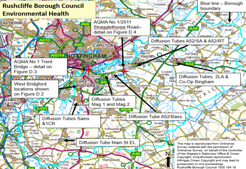
D.2 – Map Showing the diffusion tube network across West Bridgford
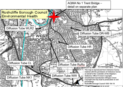
D.3 – Map Showing Location of AQMA No 1 Trent Bridge and continuous monitor and diffusion tube locations

D.4 – Map of AQMA No 1/2011 Stragglethorpe Road showing continuous monitor and diffusion tube locations
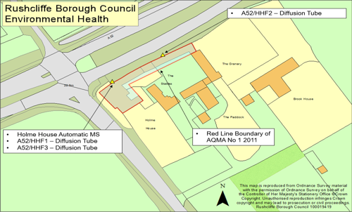
Appendix E: Summary of Air Quality Objectives in England
| Pollutant | Air Quality Objective: Concentration (units in micrograms of pollutant per cubic metre of air) | Air Quality Objective: Measured as |
|---|---|---|
| Nitrogen Dioxide (NO2) | 200 micro-gram per cubic metre of air not to be exceeded more than 18 times a year | 1 hour mean |
| Nitrogen Dioxide (NO2) | 40 micro-gram per cubic metre of air | Annual mean |
| Particulate Matter (PM10) | 50 micro-gram per cubic metre of air, not to be exceeded more than 35 times a year | 24 hour mean |
| Particulate Matter (PM10) | 40 micro-gram per cubic metre of air | Annual mean |
| Sulphur Dioxide (SO2) | 350 micro-gram per cubic metre of air, not to be exceeded more than 24 times a year | 1 hour mean |
| Sulphur Dioxide (SO2) | 125 micro-gram per cubic metre of air, not to be exceeded more than 3 times a year | 24 hour mean |
| Sulphur Dioxide (SO2) | 266 micro-gram per cubic metre of air, not to be exceeded more than 35 times a year | 15 minute mean |
Appendix F Supporting Information for Revocation of AQMAs
Supporting Information for Revocation of Air Quality Management Areas (AQMAs) No 1 Trent Bridge and No 1/2011 Stragglethorpe Road.
Local Air Quality Management (LAQM) is set out in Part IV of the Environment Act (1995) which places an obligation on all local authorities to regularly review and assess air quality in their area to determine whether or not the air quality objectives are likely to be achieved. Where an exceedance is considered likely the local authority must declare an Air Quality Management Area (AQMA) and prepare an Air Quality Action Plan (AQAP) setting out the measures it intends to put in place in pursuit of the objectives.
Rushcliffe Borough Council currently has two active AQMAs declared due to exceedances of the Air Quality Objective for the annual mean concentration of nitrogen dioxide (NO2):
- AQMA No 1 Trent Bridge; and
- AQMA No 1/2011 Stragglethorpe Road.
The elevated nitrogen dioxide levels were associated with road traffic emissions and since declaration of the AQMAs there has been a significant decrease in nitrogen dioxide levels in both areas. This is as a result of the measures implemented to reduce traffic congestion and the associated emissions, and as a result of lifestyle changes in the wider population in the more recent years.
Within AQMA No 1 Trent Bridge monitoring indicates the annual mean nitrogen dioxide concentration has been at or below the air quality threshold for the past six years; and within AQMA No1/2011 Stragglethorpe Road the annual mean concentration of nitrogen dioxide has been at or below the threshold for five years. Therefore, in accordance with LAQM guidance we are proposing to revoke both AQMAs. Each of the AQMAs is considered in more detail below.
AQMA No. 1 Trent Bridge
AQMA No. 1 Trent Bridge was declared in 2005 due to the exceedance of the annual mean Air Quality Objective for nitrogen dioxide (NO2) as detailed below. AQMA No 1 Trent Bridge covers an area along Lady Bay Bridge/Radcliffe Road/Trent Bridge/Loughborough Road junctions in West Bridgford as indicated by the red line on the location map below.
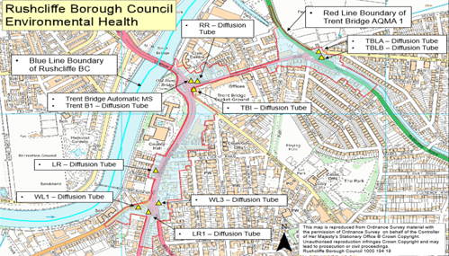
Road traffic is the main source of nitrogen dioxide (NO2) within the AQMA. The concentration of nitrogen dioxide is measured as micrograms per cubic metre of air (µg m-3) and to protect health the Government has set Air Quality Objectives. The annual objective relates to the concentration of nitrogen dioxide in the air averaged over a period of one year and aims to protect over the longer term. The annual mean objective for nitrogen dioxide is 40 micro-gram per cubic metre of air.
Details of AQMA No 1 Trent Bridge
AQMA Name & Date of Declaration
-
AQMA No 1 Trent Bridge - Declared 01/09/2005
Pollutants and Air Quality Objectives
- nitrogen dioxide Annual Mean
Description
- An area including Lady Bay Bridge/Radcliffe Road/Trent Bridge/Loughborough Road junctions in West Bridgford.
Pollutant Source
- Traffic Emissions
Level of Exceedance: Declaration
- 47 micro-grams per cubic metre
Level of Exceedance: Current Year
-
No exceedance – maximum recorded annual mean concentration - 26 micro-grams per cubic metre
Within AQMA No 1 Trent Bridge nitrogen dioxide concentrations are monitored using a continuous monitor located at Trent Bridge and a network of diffusion tubes at 10 locations across the AQMA.
We are required to submit our air quality monitoring results each year to Defra in an Annual Status Report (ASR)
In approving our 2023 ASR Defra commented:
‘The revocation of an AQMA should be considered following three consecutive years of compliance with the relevant objective as evidenced through monitoring. Where there have been no exceedances for the past five years, local authorities must proceed with plans to revoke the AQMA. The LAQM Technical Guidance 2022 is clear in this respect:
"There should not be any declared AQMAs for which compliance with the relevant objective has been achieved for a consecutive five-year period."
It is recommended that the Council should consider the revocation of both AQMAs following six and four years if compliance respectively, if the 2024 monitoring data is considered to have no exceedances and no sites within 10% of the objective.
Air Quality Monitoring in AQMA No. 1 Trent Bridge
There is currently one continuous monitor and 10 nitrogen dioxide diffusion tube monitoring locations within AQMA No 1 Trent Bridge. As can be seen below and in figures two and three in the pdf version of this report monitoring data from 2017 to 2024 demonstrates the continued downward trend in the nitrogen dioxide annual mean concentrations. Since 2020 the annual mean nitrogen dioxide concentration recorded at all monitoring locations has been below the Air Quality Objective of 40 micro-grams per cubic metre.
The information below presents the annual average nitrogen dioxide concentrations recorded by the continuous monitor and diffusion tubes located within AQMA No 1 Trent Bridge for the period from 2017 to 2024.
Annual Mean Nitrogen Dioxide Concentrations at Monitoring Locations Across AQMA No 1 Trent Bridge (2017 -2024)
Monitoring Locations and Annual Mean (average) nitrogen dioxide concentrations in micro-grams per cubic metre
Monitor - Trent Bridge
- 2017 - 37
- 2018 - 36
- 2019 - 37
- 2020 - 27
- 2021 - 29
- 2022 - 35
- 2023 - 26
- 2024 - 24 (see note 1)
Diffusion Tube ID - LR
- 2017 - 26
- 2018 - 28
- 2019 - 37
- 2020 - 27
- 2021 - 29
- 2022 - 28
- 2023 - 26
- 2024 - 24
Diffusion Tube ID - RR
- 2017 - 30
- 2018 - 31
- 2019 - 27
- 2020 - 21
- 2021 - 23
- 2022 - 20
- 2023 - 20
- 2024 - 20
Diffusion Tube ID - TBLA
- 2017 - 33
- 2018 - 31
- 2019 - 30
- 2020 - 24
- 2021 - 25
- 2022 - 22
- 2023 - 22
- 2024 - 19
Diffusion Tube ID - TBLB
- 2017 - 32
- 2018 - 32
- 2019 - 31
- 2020 - 23
- 2021 - 25
- 2022 - 22
- 2023 - 22
- 2024 - 19
Diffusion Tube ID - TBI
- 2017 - 40 (see note 2)
- 2018 - 40 (see note 2)
- 2019 - 33
- 2020 - 23
- 2021 - 27
- 2022 - 21
- 2023 - 30
- 2024 - 20
Diffusion Tube ID - WL3
- 2017 - 37 (see note 3)
- 2018 - 34
- 2019 - 39 (see note 3)
- 2020 - 28
- 2021 - 30
- 2022 - 28
- 2023 - 27
- 2024 - 26
Diffusion Tube ID - TrentB1
- 2017 - 37 (see note 3)
- 2018 - 36
- 2019 - 34
- 2020 - 25
- 2021 - 26
- 2022 - 24
- 2023 - 24
- 2024 - 22
Diffusion Tube ID - LR1
- 2017 - no data
- 2018 - no data
- 2019 - 37 (see note 3)
- 2020 - 27
- 2021 - 29
- 2022 - 27
- 2023 - 26
- 2024 - 22
Diffusion Tube ID - WL1
- 2017 - no data
- 2018 - no data
- 2019 - 30
- 2020 - 25
- 2021 - 26
- 2022 - 23
- 2023 - 24
- 2024 - 23
Diffusion Tube ID - TrentB2
- 2017 - no data
- 2018 - no data
- 2019 - no data
- 2020 - no data
- 2021 - no data
- 2022 - no data
- 2023 - no data
- 2024 - 24
Note 2: annual mean concentration at or above the Air Quality Objective of 40 micro-gram per cubic metre of air
Note 3: annual mean concentration within 10% of the Air Quality Objective of 40 micro-gram per cubic metre of air
This data is displayed graphically in Figure 2 and Figure 3 below.

For ease of clarity Figure 2 displays the monitoring data at each location from 2019 to 2024. The dashed line represents the Air Quality Objective (AQO) for the Annual Mean Nitrogen Dioxide Concentration which is 40 micro-gram per cubic metre of air. At each location there was a significant drop in the annual mean nitrogen dioxide concentration between 2019 and 2020 because of the COVID 19 pandemic. The data indicates this downward trend has continued post pandemic with the nitrogen dioxide concentrations at all locations now below 30 micro-gram per cubic metre of air which is well below the AQO of 40 micro-gram per cubic metre of air.

As the annual mean nitrogen dioxide concentrations recorded by the continuous monitor and network of diffusion tubes across AQMA No 1 Trent Bridge clearly demonstrate compliance with the Air Quality Objective we propose to revoke the AQMA.
Following revocation of the AQMA we will continue to monitor nitrogen dioxide levels in and around the Trent Bridge, Loughborough Road and Radcliffe Road area of West Bridgford using a network of diffusion tubes. We will also continue to work with the Nottinghamshire County Council as the Highway Authority to improve air quality levels and review and implement the measures detailed in Table 2.2 of our 2024 Annual Status Report and future reports.
AQMA No 1/2011 Stragglethorpe Road
AQMA No 1/2011 at Radcliffe on Trent is located at the Stragglethorpe junction of the A52 dual carriageway which is one of the main easterly routes into/out of Nottingham. The general aspect is open with a small group of residential properties in one area adjacent to the junction. This AQMA was declared in 2011 due to a nitrogen dioxide annual mean concentration of 50.5 micro-gram per cubic metre of air as detailed in Table 3 below. The extent of AQMA No 1/2011 is as shown in Figure 4 below.
Figure 4 AQMA No 1/2011 Stragglethorpe Road – Red line shows extent of AQMA and yellow triangles indicate the monitoring locations
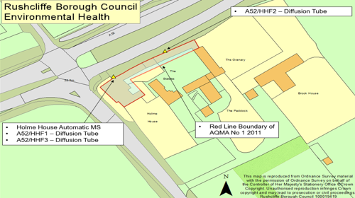
Road traffic is the main source of nitrogen dioxide within the AQMA. The concentration of nitrogen dioxide is measured as micrograms per cubic metre of air and to protect health the Government has set Air Quality Objectives. The annual objective relates to the concentration of nitrogen dioxide in the air averaged over a period of one year and aims to protect over the longer term. The annual mean objective for nitrogen dioxide is 40 micro-gram per cubic metre of air.
Details of AQMA No 1/2011 Stragglethorpe Road
AQMA Name & Date of Declaration
-
AQMA No 1/2011 Stragglethorpe Road - Declared October 2011
Pollutants and Air Quality Objectives
- nitrogen dioxide Annual Mean
Description
- Land adjacent to A52 at Stragglethorpe Lane Junction
Pollutant Source
- Traffic Emissions
Level of Exceedance: Declaration
- 50.5 micro-grams per cubic metre
Level of Exceedance: Current Year
-
No exceedance – maximum recorded annual mean concentration - 24 micro-grams per cubic metre of air
Within AQMA No 1/2011 Stragglethorpe Road nitrogen dioxide concentrations are currently monitored using a continuous monitor located at Holme House and diffusion tubes at 3 locations across the AQMA as shown in Figure above. We are required to submit our air quality monitoring results each year to Defra in an Annual Status Report (ASR)19.
In approving our 2024 ASR Defra commented:
‘The revocation of an AQMA should be considered following three consecutive years of compliance with the relevant objective as evidenced through monitoring. Where there have been no exceedances for the past five years, local authorities must proceed with plans to revoke the AQMA. The LAQM Technical Guidance 2022 is clear in this respect:
"There should not be any declared AQMAs for which compliance with the relevant objective has been achieved for a consecutive five-year period."
It is recommended that the Council should consider the revocation of both AQMAs following six and four years if compliance respectively, if the 2024 monitoring data is considered to have no exceedances and no sites within 10% of the objective.
Air Quality Monitoring in AQMA No 1/2011 Stragglethorpe Road
There is currently one continuous monitor and 3 nitrogen dioxide diffusion tube monitoring locations within AQMA No 1/2011 Stragglethorpe Road. As can be seen below the monitoring data from 2017 to 2024 demonstrates the continued downward trend in the nitrogen dioxide annual mean concentrations. Since 2020 the annual mean nitrogen dioxide concentration recorded at all monitoring locations has been below the Air Quality Objective of 40 micro-gram per cubic metre of air.
The information below presents the annual average nitrogen dioxide concentrations recorded by the continuous monitor and diffusion tubes located within AQMA No1/2011 for the period from 2017 to 2024.
Monitoring Locations and Annual Mean (average) nitrogen dioxide concentrations in micro-grams per cubic metre
Monitor - Holme House
- 2017 - 38 (see note 3)
- 2018 - 39 (see note 3)
- 2019 - 41 (see note 2)
- 2020 - 31
- 2021 - 33
- 2022 - 35
- 2023 - 23
- 2024 - 21 (see note 1)
Diffusion Tube ID - A52/HHF1
- 2017 - 37 (see note 3)
- 2018 - 38 (see note 3)
- 2019 - 37 (see note 3)
- 2020 - 24
- 2021 - 27
- 2022 - 26
- 2023 - 25
- 2024 - 24 (see note 1)
Diffusion Tube ID - A52/HHF3
- 2017 - No data
- 2018 - No data
- 2019 - No data
- 2020 - No data
- 2021 - No data
- 2022 - No data
- 2023 - 23
- 2024 - 24 (see note 1)
Diffusion Tube ID - A52/HHF4
- 2017 - 40 (see note 2)
- 2018 - 41 (see note 2)
- 2019 - 39 (see note 3)
- 2020 - 38 (see note 3)
- 2021 - 29
- 2022 - 25
- 2023 - 22
- 2024 - 23 (see note 1)
Note 2: annual mean concentration at or above the Air Quality Objective of 40 µg m-3
Note 3: annual mean concentration within 10% of the Air Quality Objective of 40 µg m-3
The data is displayed graphically in Figure 5 below. The dashed line represents the Air Quality Objective (AQO) for the Annual Mean Nitrogen Dioxide Concentration of 40 micro-gram per cubic metre of air. At each location there was a significant drop in the annual mean nitrogen dioxide concentration between 2019 and 2020 because of the COVID 19 pandemic. The data indicates this downward trend has continued post pandemic with the nitrogen dioxide concentrations at all locations well below the AQO of 40 micro-gram per cubic metre of air.

As the annual mean nitrogen dioxide concentrations recorded by the continuous monitor and diffusion tubes in AQMA No 1/2011 Stragglethorpe Road clearly demonstrate compliance with the Air Quality Objective we propose to revoke the AQMA.
Following revocation of the AQMA we will continue to monitor nitrogen dioxide levels by diffusion tube in the vicinity of the junction. We will also continue to work with the National Highways as the Highway Authority to improve air quality levels and review and implement the measures detailed in Table 2.2 of the 2024 Annual Status Report and future reports.
Local Air Quality Management Technical Guidance
The Local Air Quality Management Technical Guidance (TG22) (Defra 2022) states:
- There should not be any declared AQMAs for which compliance with the relevant objective has been achieved for a consecutive five-year period.
- The revocation of an AQMA should be considered following three consecutive years of compliance with the relevant objective as evidenced through monitoring.
- Where nitrogen dioxide monitoring is completed using diffusion tubes, to account for the inherent uncertainty associated with the monitoring method, it is recommended that revocation of an AQMA should be considered following three consecutive years of annual mean nitrogen dioxide concentrations being lower than 36μg/m3 (i.e. within 10% of the annual mean nitrogen dioxide objective).
On the issue of using data impacted by the COVID-19 lockdowns: “It is not advisable for the revocation of an AQMA to be based solely upon compliance in a year not representative of long-term trends. For example, compliance being reached in 2020 may not be representative of long-term trends in pollutant concentrations due to the change in activity observed across the UK as a result of COVID-19 and associated lock down measures. Where 2020 is one of many consecutive years of compliance, this may be considered for revocation.” Finally, before revoking an AQMA on the basis of measured pollutant concentrations, the authority needs to be reasonably certain that any future exceedances (that might occur in more adverse meteorological conditions) are unlikely.
TG 22 Requirements
Three consecutive years of compliance with the relevant objective?
- AQMA No 1 Trent Bridge = Yes
- AQMA No 1/2011 Stragglethorpe Road = Yes
Diffusion Tube data - three consecutive years of annual mean nitrogen dioxide concentrations being lower than 36 micro-gram per cubic metre of air (i.e. within 10% of the annual mean nitrogen dioxide objective)?
- AQMA No 1 Trent Bridge = Yes
- AQMA No 1/2011 Stragglethorpe Road = Yes
As the annual mean nitrogen dioxide concentrations recorded by the continuous monitors and network of diffusion tubes across both AQMA No 1 Trent Bridge and AQMA No 1/2011 Stragglethorpe Road clearly demonstrate compliance with the Air Quality Objective we propose to revoke the AQMAs.
Glossary of Terms
| Abbreviation | Description |
|---|---|
| AQMA | Air Quality Management Area – An area where air pollutant concentrations exceed / are likely to exceed the relevant air quality objectives. AQMAs are declared for specific pollutants and objectives |
| AQO | Air Quality Objective |
| ASR | Annual Status Report – report prepared every year by Rushcliffe Borough Council for submission and approval by Defra. Rushcliffe Borough Council Annual Status Reports are available on our webpage |
| Defra | Department for Environment, Food and Rural Affairs |
| NO2 | Nitrogen Dioxide is a gas which is generally emitted from high temperature combustion processes such as road transport or energy generation. |
Officer Notes
Calculations undertaken prior to the release of the 2025 Diffusion Tube Processing Tool for use with the 2024 data. Therefore, the 2024 tool has been used.
Continuous monitor data has not yet been ratified.
| Data Input | Value Selected | Justification |
|---|---|---|
| Bias Adjustment Factor | 0.81 | National Bias Adjustment Factors | LAQM Taken from Diffusion Tube Bias Adjustment Factors Spreadsheet – version number 09/24 released September 2024 Gradko; 20% TEA in Water; based on 27 studies |
| Calendar Inputs | 2023 dates used | No impact on the calculations as the 2024 deployment dates are in accordance with the 2024 Calendar Inputs |
| Continuous Monitor Data | Data for 2024 | Not yet ratified |
Related Reports
Annual Status Reports
Every year Local Authorities in England are required to submit an Air Quality Annual Status Report (ASR) for Defra approval.
Our Air Quality Annual Status Reports are available at Air Quality Reports - Rushcliffe Borough Council
Air Quality Action Plan
Our Air Quality Action Plan (AQAP) 2021 -2026 is available at Air Quality Management Areas - Rushcliffe Borough Council
In 2021 the Borough Council updated its action plan which contains measures aimed at working towards reducing traffic pollution in AQMAs due to levels of nitrogen dioxide. The action plan has been drawn up with relevant organisations such as the Nottinghamshire County Council, National Highways and other council departments.
Prepared to support consultation in proposed revocation of AQMA No 1 Trent Bridge and AQMA No 1/2011 Stragglethorpe Road.
Glossary of Terms
| Abbreviation | Description |
|---|---|
| AQAP | Air Quality Action Plan - A detailed description of measures, outcomes, achievement dates and implementation methods, showing how the local authority intends to achieve air quality limit values’ |
| AQDM | Air Quality Data Management - the company that collects and processes Rushcliffe Borough Council’s continuous monitor air quality data |
| AQMA | Air Quality Management Area – An area where air pollutant concentrations exceed / are likely to exceed the relevant air quality objectives. AQMAs are declared for specific pollutants and objectives |
| ASR | Annual Status Report |
| ATP | Active Travel Fund |
| AURN | Automatic Urban and Rural Network - The AURN is the UK's largest automatic monitoring network and is the main network used for compliance reporting against the Ambient Air Quality Directives |
| BSIP | Bus Service Implementation Plans |
| CO2 | Carbon Dioxide |
| D2N2 | Local Enterprise Network area covering Derby, Derbyshire, Nottingham and Nottinghamshire |
| (D2N2) LEAP | D2N2 Local Energy Area Plan |
| D2N2 LEP | D2N2 Local Enterprise Partnership |
| Defra | Department for Environment, Food and Rural Affairs |
| DfT | Department for Transport |
| DMRB | Design Manual for Roads and Bridges – Air quality screening tool produced by National Highways |
| EMCCA | East Midlands Combined County Authority |
| ERDF | European Regional Development Fund |
| EU | European Union |
| EV | Electric Vehicle |
| EVCC | Electric Vehicle Cable Channels |
| EVCP | Electric Vehicle Charging Points |
| FDMS | Filter Dynamics Measurement System |
| HECC | Health Effects of Climate Change |
| HVO | Hydrogenated Vegetable Oil |
| ITSO | Integrated Transport Smartcard Organisation |
| LAQM | Local Air Quality Management |
| LCWIP | Local Cycling and Walking Infrastructure Plan |
| LEVI | Local Electric Vehicle Infrastructure (Office for Zero Emission Vehicles) - Fund supports local authorities in England to plan and deliver chargepoint infrastructure for residents without off-street parking |
| LPG | Liquified Petroleum Gas |
| LTP | Local Transport Plan (Nottinghamshire County Council) |
| NCC | Nottinghamshire County Council |
| NCiC | Nottingham City Council |
| NCT | Nottingham City Transport |
| NEPWG | Nottinghamshire Environmental Protection Working Group |
| NH | National Highways |
| NO2 | Nitrogen Dioxide |
| NOx | Nitrogen Oxides |
| OHID | Office for Health Improvement and Disparities |
| OZEV | Office for Zero Emission Vehicles |
| PHOF | Public Health Outcomes Framework |
| PM10 | Airborne particulate matter with an aerodynamic diameter of 10µm or less |
| PM2.5 | Airborne particulate matter with an aerodynamic diameter of 2.5µm or less |
| QA/QC | Quality Assurance and Quality Control |
| RBC | Rushcliffe Borough Council |
| REGO | Renewable Energy Guarantee of Origin |
| SCA | Smoke Control Area |
| SO2 | Sulphur Dioxide |
| TEA | Triethanalamine |
| UKHSA | United Kingdom Health Security Agency (formerly known as Public Health England) |
| UKSPF | United Kingdom Shared Prosperity Fund (Department of Levelling Up, Housing & Communities) |
| ULEV | Ultra Low Emissions Vehicles |
| ZEBRA | Zero Emission Bus Regional Areas |
References
- Local Air Quality Management Technical Guidance LAQM.TG22. August 2022. Published by Defra in partnership with the Scottish Government, Welsh Assembly Government and Department of the Environment Northern Ireland.
- Local Air Quality Management Policy Guidance LAQM.PG22. August 2022. Published by Defra in partnership with the Scottish Government, Welsh Assembly Government and Department of the Environment Northern Ireland.
- Chemical hazards and poisons report: Issue 28. June 2022. Published by UK Health Security Agency
- Air Quality Strategy – Framework for Local Authority Delivery. August 2023. Published by Defra.
- Copeland B (2021) A comparison of gas and electric cremator emissions in the UK. A dissertation submitted to the School of Energy, Construction and Environment, Faculty of Engineering, Environment and Computing, Coventry University in partial fulfilment of the requirements for the degree of Geography BSc (Hons)
- Air Quality Strategy for Nottingham and Nottinghamshire 2020 – 2030. Published by Nottingham City Council, Nottinghamshire County Council and the seven Nottinghamshire Local Authorities.
- Road to Zero - Next steps towards cleaner road transport and delivering our Industrial Strategy. July 2018. Published by Department for Transport.
- Environmental Improvement Plan – First Revision of the 25 year Environment Plan. 2023. Published by Defra.
Accessible Documents
- Air Quality Action Plan 2021
- Air Quality Annual Status Report 2024
- Air Quality Annual Status Report 2023
- Air Quality Annual Status Report 2022
- Air Quality Annual Status Report 2021
- Air Quality Strategy for Nottingham and Notts
- Annual Governance Statement 2023-24
- Annual Governance Statement 2021-22
- Annual Governance Statement 2020-21
- Asset Management Strategy
- Auditor's Annual Report 2021
- Internal Audit Annual Report 2021/22
- Auditor's Annual Report 2021-22
- Become a Councillor 2022
- Budget and Financial Strategy 2021-22
- Budget and Financial Strategy 2022-23
- Budget and Financial Strategy 2023-24
- Budget and Financial Strategy 2024-25
- Capital and Investment Strategy
- Climate Change Strategy 2021-2030
- Complaints Policy
- Compulsory Purchase Order Procedure Protocol
- Confidential Reporting Code
- Council Constitution
- Contaminated Land
- Corporate Enforcement Policy
- Corporate Strategy 2024-2027
- Council Tax Recovery and Enforcement Policy 2025
- Customer Access Strategy
- Design Code Baseline Appraisal
- Discretionary Housing Payments Policy 2024-2025
- Disabled Facilities Grant Policy
- Disclosure and Barring Service Policy
- Economic Growth Strategy 2024
- Empty Homes Strategy
- Environment Policy 2023
- Equalities Scheme 2021-25
- External Audit Completion Report 2024
- External Audit Completion Report 2023
- External and Internal Communications Strategy
- Freedom Of Information Policy
- HB Recovery and Enforcement Policy
- Hackney Carriage and Private Hire Licensing Policy 2020 - 2025
- Homelessness and Rough Sleeping Strategy
- Housing Allocations Policy
- Housing Enforcement Policy
- ICT Strategy 2022 -25
- Information Management and Governance Strategy 2022-25
- Rushcliffe Borough Council Information Retention Schedule
- Internal Audit Annual Report 2023/24
- Leisure Strategy 2021-2027 review
- Local Code of Corporate Governance 2024/25
- Local Plan Part 1: Core Strategy
- Local Plan Part 2: Land and Planning Policies
- Local Plan Monitoring Report
- Local Scheme of Validation
- Off-street Car Parking Strategy
- Pay Policy Statement
- People Strategy 2021-26
- Planning Enforcement Policy
- Play Strategy
- Procurement Strategy
- Playing Pitch Strategy 2022
- 2021-22 Public Inspection Notice
- RIPA Policy and Guidance
- Risk Management Strategy 2023-26
- Rushcliffe Nature Conservation Strategy
- Solar Farm Landscape Sensitivity and Capacity Study
- Statement of Gambling Licensing Principles
- Statement of Accounts 2019-20
- Statement of Accounts 2020-21
- Statement of Accounts 2021-22
- Statement of Accounts 2021-22 (unaudited)
- Statement of Accounts 2022-23 (unaudited)
- Statement of Accounts 2022-23 (audited)
- Statement of Accounts 2023-24 (audited)
- Statement of Licensing Policy
- Street Trading Policy
- Supplementary Planning Documents
- Tenancy Strategy 2019
- Transformation Strategy and Efficiency Plan
- Tree Management and Protection Policy 2023
- WISE Agreement
- Conservation Areas
- Neighbourhood Plans
- The Nature of Rushcliffe 2021
- The Nature of Rushcliffe 2019
- Anti-Slavery Policy
- Modern Slavery & Human Trafficking Transparency Statement 2024-2025
- Annual Infrastructure Funding Statements
- Anti-Fraud & Corruption Policy 2025
- Communications and Engagement Strategy 2025-28
- Air Quality Annual Status Report 2025
- Draft Statement of Accounts 2024-25
- Rushcliffe Design Code
- Audited Statement of Accounts 2024-25
- Technology, Digital and Customer Access Strategy
- Budget and Financial Strategy 2025-26
- Annual Governance Statement 2024-25
- Rushcliffe Nature Conservation Strategy